The landforms and landscapes of Scotland are commonly perceived as being dominated by the legacy of successive Pleistocene glaciations. In the Highlands, Hebrides and Southern Uplands, glacier ice has sculpted the landscape into cliffs, corries, arêtes, glacial troughs and rock basins. Lowland areas underlain by resistant bedrock are characterised by ice-scoured topography, and those underlain by sedimentary rocks are often buried under a thick mantle of glacigenic deposits. Since the last Pleistocene glaciers vanished from Scotland, however, the Scottish landscape has been subject to modification by a wide range of postglacial processes: entire mountainsides have shifted or collapsed; glacigenic sediments have been extensively reworked by landslides and debris flows; rivers have incised and migrated across their floodplains; frost action and strong winds have modified high plateaux; and the coastal zone has responded to changes in sea-level and sediment flux.
This review synthesises current understanding of the postglacial evolution of the Scottish landscape. Following a brief introduction to the nature and chronology of postglacial environmental changes in Scotland and the role of paraglacial landscape modification, current understanding of landscape evolution under the striking environmental changes of the Lateglacial period (from the time of ice-sheet deglaciation until ∼11.7 ka) is outlined, followed by an assessment of ways in which the landforms and landscapes of Scotland have evolved under the comparatively climatically stable environment of the Holocene (∼11.7 ka to the present). Postglacial changes in sea level and coastal configuration are reviewed in this issue by Smith et al. (Reference Smith, Barlow, Bradley, Firth, Hall, Jordan and Long2018), and are considered here only where relevant to the understanding of river systems. Key locations mentioned in the text are shown in Figure 1.
Figure 1 Location of key sites mentioned in the text.
1. Chronology of deglaciation and postglacial environmental change
Throughout this review, ages are expressed as either thousands of years (ka) or years (a) before present. Uncalibrated radiocarbon ages are identified as 14C a BP or 14C ka BP, where ‘BP' (‘before present') refers by convention to AD 1950, and calibrated radiocarbon ages as cal 14C a or cal 14C ka referenced to AD 2000. For consistency, radiocarbon ages have been calibrated with the CALIB 7.10 calibration software (Stuiver et al. Reference Stuiver, Reimer and Reimer2016), using the IntCal13 dataset (Reimer et al. Reference Reimer, Bard and Bayliss2013). Terrestrial cosmogenic nuclide (TCN) exposure ages cited here assume a post-exposure erosion rate of 1 mm ka–1; assumption of zero erosion reduces 10Be exposure ages by ∼1 %, and assumption of an erosion rate of 2 mm ka–1 increased ages by ∼1 %. 10Be ages have been recalibrated using the Loch Lomond production rate (Fabel et al. Reference Fabel, Ballantyne and Xu2012), using the Lm scaling of the CRONUS-Earth online calculator (Balco et al. Reference Balco, Stone, Lifton and Dunai2008). Cited uncertainties for exposure ages are total (external) uncertainties at ±1σ.
The last ice-sheet glaciation of Scotland occurred during the Dimlington Stade (∼31–14.7 ka) of the Late Devensian (=Late Weichselian) substage. At its maximum extent, the last ice sheet buried all Scottish mountains, extended far westward onto the Atlantic shelf, and to the east was confluent with the Fennoscandian Ice Sheet in the North Sea Basin (Bradwell et al. Reference Bradwell, Stoker, Golledge, Wilson, Merritt, Long, Everest, Hestvik, Stevenson, Hubbard, Finlayson and Mathers2008; Hubbard et al. Reference Hubbard, Bradwell, Golledge, Hall, Patton, Sugden, Cooper and Stoker2009; Ballantyne 2010a; Clark et al. Reference Clark, Hughes, Greenwood, Jordan and Sejrup2012; Ballantyne & Small Reference Ballantyne and Small2018 – this volume). During the Last (global) Glacial Maximum (∼27–19 ka), therefore, all of the present land area of Scotland (apart from the St Kilda archipelago) was buried under glacier ice, and the timeline of postglacial landscape evolution begins when the land surface emerged from under the retreating ice-sheet (Fig. 2). The term ‘Lateglacial' is here used to denote the period between ice-sheet deglaciation and the onset of the Holocene at ∼11.7 ka.
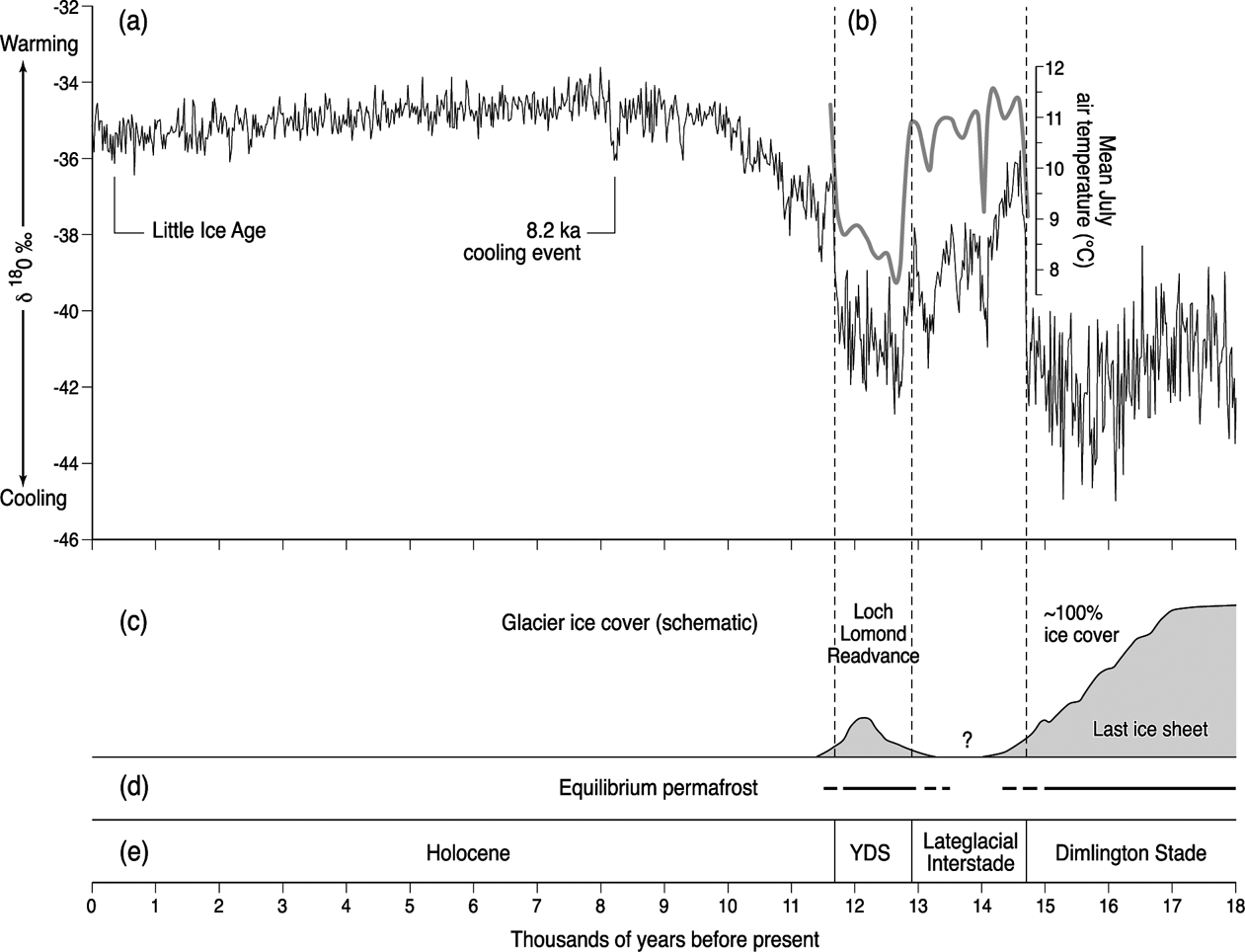
Figure 2 Environmental change over the past 18,000 years: (a) Greenland NGRIP ice core δ18O record, which indicates periods of relative cooling and warming; (b) Lateglacial July air temperatures inferred from chironomid assemblages recovered from Whitrig Bog in SE Scotland, showing rapid summer warming at ∼14.7 ka and ∼11.7 ka (Brooks & Birks Reference Brooks and Birks2000); (c) schematic representation of glacier ice cover, 18–11 ka; (d) periods when equilibrium permafrost probably extended to sea level in Scotland; (e) major chronological subdivisions of the postglacial period in Scotland. YDS=Younger Dryas Stade.
Ice-sheet deglaciation across Scotland was spatially diachronous, spanning the interval ∼21–14 ka. By ∼17 ka, most of Scotland was still ice-covered, apart from parts of the Outer Hebrides, the extreme NW mainland, Caithness and the eastern seaboard. By ∼16 ka, the Solway lowlands, Orkney and Shetland were deglaciated, the ice margin lay amongst the Inner Hebrides and along the W coast, nunataks had emerged from under the ice in Wester Ross, the ice margin had retreated to the Cairngorms and the sea had invaded the Forth and Tay estuaries. By ∼15 ka, most of the Southern Uplands, the Midland Valley and NW Scotland and the Eastern Grampians were ice-free and a residual ice cap or icefield occupied the western Highlands (Ballantyne & Small Reference Ballantyne and Small2018 – this volume).
Before ∼14.7 ka, terrain vacated by the retreating ice sheet was exposed to severe periglacial conditions, with evidence for the development of permafrost to present sea level (Fig. 2). Analysis of subfossil coleopteran assemblages in Lateglacial sediments (Atkinson et al. Reference Atkinson, Briffa and Coope1987) has suggested that during the final part of the Dimlington Stade, mean annual air temperatures were within the range −5°C to −10°C, with mean January temperatures of −20°C to −25°C. Around 14.7 ka, strengthening of Atlantic meridional overturning circulation returned much warmer surface waters to the coasts around Scotland, causing a rapid rise in summer temperatures (Brooks & Birks Reference Brooks and Birks2000; Brooks et al. Reference Brooks, Matthews, Birks and Birks2012) and ushering in the cool temperate climate of the Lateglacial Interstade (14.7–12.9 ka; Fig. 2).
There is debate as to whether remnants of the shrinking ice sheet persisted in favourable locations during the Lateglacial Interstade but, if so, they must have been restricted to some high plateaux and corries (Hubbard et al. Reference Hubbard, Bradwell, Golledge, Hall, Patton, Sugden, Cooper and Stoker2009; Finlayson et al. Reference Finlayson, Golledge, Bradwell and Fabel2011), and it is reasonable to assume that all or almost all low ground was ice-free by ∼14 ka (Ballantyne & Stone Reference Ballantyne2012; Ballantyne & Small Reference Ballantyne and Small2018 – this volume). Subsequent cooling resulted in a readvance of glacier ice, the Loch Lomond Readvance (LLR), which reached its maximum extent during the Loch Lomond Stade of ∼12.9–11.7 ka, the Scottish equivalent of the Younger Dryas Stade (YDS). During the thermal nadir of the YDS, mean July sea-level temperatures in Scotland were ∼7°C or slightly lower (Brooks et al. Reference Brooks, Matthews, Birks and Birks2012) and (with lower confidence) mean January temperatures were probably about −20°C (Atkinson et al. Reference Atkinson, Briffa and Coope1987), implying mean annual temperatures of roughly −6°C, although slightly colder conditions probably prevailed in northern Scotland. Under these conditions a substantial ice cap or icefield reoccupied much of the Western Highlands, flanked by smaller peripheral icefields in Skye, Mull, the northern Highlands, Monadhliath and Eastern Grampians, and numerous smaller corrie and valley glaciers; small glaciers also developed in the Tweedsmuir and Galloway Hills of the Southern Uplands (Golledge Reference Golledge2010; Fig. 3). Most LLR glaciers probably reached their maximum extent and began to retreat by ∼12.5–12.2 ka (Golledge et al. Reference Golledge, Hubbard and Sugden2008; Ballantyne Reference Ballantyne2012; Bromley et al. Reference Bromley, Putnam, Rademaker, Lowell, Schaefer, Hall, Winckler, Birkel and Borns2014), although there is evidence that some did not achieve their maximum extent until near the end of the YDS (MacLeod et al. Reference MacLeod, Palmer, Lowe, Rose, Bryant and Merritt2011) and that glacier ice may have persisted in some areas as late as ∼11.5 ka (Small & Fabel Reference Small and Fabel2016). The timeline for postglacial landscape evolution within the limits of the LLR is therefore much shorter (∼12.5–11.5 ka to the present) than that for terrain outside these limits (∼21–14 ka to the present). An additional implication is that areas outside the limits of the LLR experienced renewed periglacial (permafrost) conditions during the ∼1.2 ka of the YDS (see Fig. 2 and section 3.1.1 below).

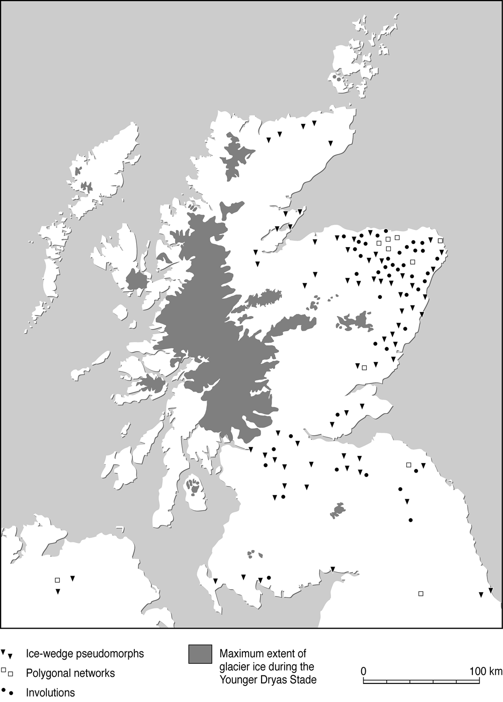
Figure 3 Maximum extent of glaciation during the Younger Dryas Stade, and documented distribution of landforms indicative of Lateglacial permafrost (ice-wedge pseudomorphs, involutions and polygonal crop marks representing former contraction crack polygons).
The Holocene was initiated at ∼11.7 ka, when a resumption or strengthening of Atlantic meridional circulation returned warm oceanic waters to the latitude of Scotland, causing a rapid climate warming (Atkinson et al. Reference Atkinson, Briffa and Coope1987; Brooks et al. Reference Brooks, Matthews, Birks and Birks2012; Fig. 2) and the disappearance of residual LLR glaciers. Temperate conditions similar to those of the present were established by ∼11.0 ka. Much of the early Holocene was characterised by relatively warm summers (the Holocene thermal maximum, or ‘climatic optimum') followed by a very slight cooling trend over the past 5000 years, during which ‘average' temperatures oscillated by up to ±2°C over decades or longer (Briffa & Atkinson Reference Briffa, Atkinson, Hulme and Barrow1997; Rydval et al. Reference Rydval, Loader, Gunnarson, Druckenbrod, Linderholm, Moreton, Wood and Wilson2017). In the northern hemisphere, this overall pattern was interrupted by several brief cooling events centred around 9.2 ka, 8.2 ka, 6.3 ka, 4.7 ka, 2.7 ka and 1.5 ka (Wanner et al. Reference Wanner, Solomina, Grosjean, Ritz and Jetel2011), although the nature of climate change in Scotland at these times is uncertain. Multi-proxy evidence from peat bogs also indicates at least local shifts in wetness over the past five millennia (Blundell & Barber Reference Blundell and Barber2005; Langdon & Barber Reference Langdon and Barber2005). Apart possibly from the 8.2 ka cooling event, the most severe period of Holocene cooling in Scotland was the ‘Little Ice Age', a period of general climatic deterioration conventionally attributed to the 16th–19th centuries AD, although cooling may have begun two or three centuries earlier (Matthews & Briffa Reference Matthews and Briffa2005; Wanner et al. Reference Wanner, Solomina, Grosjean, Ritz and Jetel2011). Historical evidence shows that particular decades during the Little Ice Age were characterised by cool, wet summers, exceptional storminess and the survival of perennial snowcover on high ground (e.g., Whittington Reference Whittington1985; Lamb Reference Lamb1991; Dawson Reference Dawson2009), although parts of E Scotland experienced mean annual precipitation lower than now (Thom & Ledger Reference Thom and Ledger1976). Summer temperature reconstructions based on tree-ring evidence suggest that within the period AD 1580–1810, summer temperatures in the northern Cairngorms averaged about 1°C lower than the 1961–1990 average (Rydval et al. Reference Rydval, Loader, Gunnarson, Druckenbrod, Linderholm, Moreton, Wood and Wilson2017). Some authors have argued that niche glaciers may have formed in the Cairngorms at this time (Harrison et al. Reference Harrison, Rowan, Glasser, Knight, Plummer and Mills2014; Kirkbride et al. Reference Kirkbride, Everest, Benn, Gheorghiu and Dawson2014), but the dating and modelling evidence on which their arguments are based appear inconclusive; the wide range of reported TCN ages used to support this interpretation could equally be interpreted in terms of the progressive disinterment of boulders as the moraines in which they were embedded were slowly eroded by snow avalanches.
2. Paraglacial landscape modification
The downwastage and retreat of glacier ice often results in the exposure of metastable, glacially-conditioned sediment sources that are subsequently released and reworked by various processes over a wide range of timescales (Ballantyne Reference Ballantyne2002a, Reference Ballantyneb; Mercier Reference Mercier2011). Rock masses released from the weight of overlying glacier ice experience major changes in the state of stress, and the propagation of stress-release joints precipitates failure in the form of rockfalls, rockslides, rock avalanches and large-scale slope deformation (McColl Reference McColl2012). Glacigenic sediments on slopes may be reworked by landslides, debris flows, snow avalanches and mountain torrents. Valley-floor glacigenic sediments are eroded, transported and deposited by rivers, forming alluvial fans and valley fills, or deltas and bottom sediments in lakes and fjords. The paraglacial system may be envisaged as an interrupted sediment cascade (Fig. 4), in which non-renewable sediment sources (unstable rockwalls, drift-mantled slopes and valley-floor glacigenic sediments) are released or entrained by a range of processes towards terminal sediment sinks. However, source-to-sink transport is often interrupted by sediment redeposition in paraglacial sediment stores such as talus accumulations, debris cones, alluvial fans, valley fills and river terraces. Some sediment stores continue to accumulate over several millennia, but others experience degradation within a few centuries or millennia (Ballantyne Reference Ballantyne2002a, Reference Ballantyne, Elias and Mock2013a).
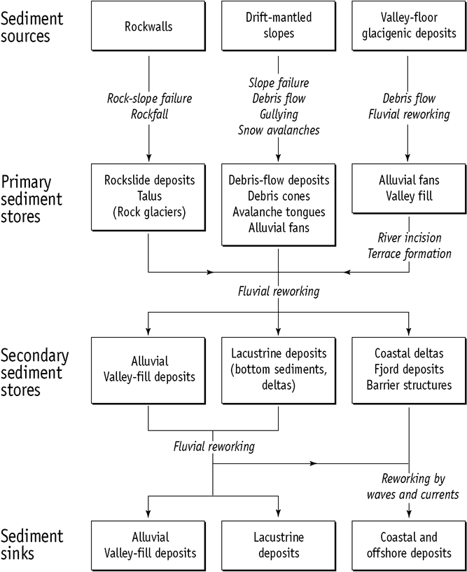
Figure 4 Simplified terrestrial paraglacial sediment cascade. Most primary sediment stores have experienced a transition from net accumulation to net erosion during the postglacial period. Adapted from Ballantyne, C. K. (Reference Ballantyne2002a) Quaternary Science Reviews 21, 1935–2017, with permission from Elsevier.
Ballantyne (Reference Ballantyne2008) has explored the implications of paraglacial landscape modification for Holocene landform evolution in the Scottish Highlands. The most important conclusions are: (1) that sediment transfer processes tended to be greatly enhanced in the immediate aftermath of deglaciation, and to decline thereafter; and (2) that paraglacial sediment stores experienced an eventual change from net accumulation to net erosion, reflecting the non-renewable nature of paraglacial sediment sources (Ballantyne Reference Ballantyne2003a). This latter concept explains why many postglacial landforms in Scotland (talus accumulations, debris cones and alluvial fans) are essentially relict features where erosion or incision has replaced deposition as the dominant mode of geomorphic activity. It also explains why many postglacial floodplains appear to have experienced initial aggradation succeeded by river incision and terrace development, although other influences (exceptional storm events, changes in base level, woodland clearance and land-use changes) are superimposed on the general model of paraglacial landform evolution (Lewin et al. Reference Lewin, Macklin and Johnstone2005). Ballantyne (Reference Ballantyne2008) also emphasised that some aspects of postglacial landscape evolution are independent of prior glacial conditioning.
3. Lateglacial landscape evolution
3.1. Lateglacial periglaciation in lowland Scotland
3.1.1. Permafrost
There is abundant evidence for the development of Lateglacial permafrost in Scotland, mainly in the form of ice-wedge pseudomorphs (ice-wedge casts) and polygonal crop marks. Both represent thermal contraction crack networks developed in former permafrost. Ice-wedge pseudomorphs form through thaw of ice wedges and infill of the resultant void by adjacent and overlying material, producing V-shaped structures that interrupt the bedding of the host sediment. Polygonal crop marks, generally 5–50 m wide, represent differences in the moisture retention properties of soil infilling the polygonal pattern of troughs above ice-wedge pseudomorphs compared with those of adjacent ground, so that plant growth in troughs is enhanced or retarded, and the ghost of the original polygonal thermal contraction crack network remains visible on aerial or satellite images.
The most comprehensive inventory of wedge structures in Scotland remains that of Galloway (Reference Galloway1961), updated by Ballantyne (Reference Ballantyne and Gordon1997). These are typically 1.5–3.0 m long, dimensions consistent with the former growth of epigenetic ice wedges that formed within pre-existing permafrozen sediment, though Aitken (Reference Aitken1998) has attributed some exceptionally large wedge structures in outwash deposits to melt-out of buried glacier ice. The majority of reported ice-wedge pseudomorphs are preserved in stratified glacifluvial sands and gravels, probably because wedge structures in till or fine-grained sediments are often destroyed during thaw, and hence have limited preservation potential (Murton & French Reference Murton and French1993a). Some structures recorded as ice-wedge pseudomorphs may actually represent sand wedges (in which the original crack infill consisted of windblown sand rather than ice) or former composite wedges, where the original infill comprised both ice veins and sand (Murton Reference Murton, Elias and Mock2013). These structures are also diagnostic of thermal contraction cracking of former permafrost, but imply either regional aridity and sparse vegetation cover, or a nearby source of aeolian sand such as an unvegetated braidplain.
Although wedge structures >1 m long and thermal contraction polygons >5 m wide indicate former extensive (usually continuous) permafrost, severe winter cold and rapid winter cooling, there is debate regarding their relationship to mean annual air temperature (MAAT; cf. Murton & Kolstrup Reference Murton and Kolstrup2003; Plug & Werner Reference Plug and Werner2008; Murton Reference Murton, Elias and Mock2013). Thermal contraction cracking of permafrost has been reported from areas where MAATs are as high as −3.5°C, but thermal contraction cracking in sands and gravels is generally believed to occur where MAATs are below −6°C to −8°C (Huijzer & Vandenberghe Reference Huijzer and Vandenberghe1998), though this ‘warm side' estimate should be regarded as indicative rather than definitive (Ballantyne Reference Ballantyne2017).
All convincing recorded examples of ice-wedge pseudomorphs and relict thermal contraction crack polygons in Scotland occur outside the limits of the LLR, mainly in lowland areas of Buchan and the Midland Valley (Fig. 3). This distribution implies that widespread permafrost developed in these areas either on terrain vacated by the retreat of the last ice sheet during the late Dimlington Stade (roughly 17–14.7 ka) or during the YDS (∼12.9–11.7 ka). It is possible that thermal contraction crack networks developed during the former period were reactivated during the latter, but no evidence of rejuvenated wedge structures has been reported. Some authors, notably Rose (Reference Rose1975) and Gemmell & Ralston (Reference Gemmell and Ralston1984) have argued for ice-wedge formation during the YDS, but the field evidence on which their arguments are based is equivocal (Ballantyne & Harris Reference Ballantyne and Harris1994, p. 288). Periglacial evidence from elsewhere in the British Isles and Western Europe nevertheless indicates that permafrost probably developed down to sea level in Scotland both in the wake of the retreating ice sheet and again during the YDS (Isarin Reference Isarin1997; Ballantyne Reference Ballantyne2017). There is evidence for YDS ice-wedge formation as far south as Lincolnshire (Worsley Reference Worsley2014), and in southern England active-layer detachment deposits overlie organic deposits of Lateglacial Interstadial age, implying at least discontinuous permafrost during the YDS (Chandler et al. Reference Chandler, Kellaway, Skempton and Wyatt1976; Spink Reference Spink1991; Hutchinson Reference Hutchinson2010).
The presence of Lateglacial permafrost in Scotland has also been inferred from the presence of nearsurface involutions in sediments of Late Devensian age. Involutions take the form of perturbations within stratified sediments, or vertical interdigitation of two or more sediment layers with contrasting textural properties. Upward sediment movement is represented by diapiric and dyke-like structures, and downward sediment movement by synclinal and bulbous structures, or ball-and-pillow forms comprising upper unit sediment encased within a lower sediment unit. Most involutions represent load casting attributable to density inversion during thaw of ice-rich soils, although some authors have attributed their formation to differential seasonal frost penetration, or to cryohydrostatic pressures generated in freezing soil (Vandenberghe Reference Vandenberghe, Elias and Mock2013). In Scotland, documented involutions have a distribution similar to that of ice-wedge pseudomorphs and polygons (Fig. 3), and have usually been interpreted as cryoturbation structures formed in the active layer above former permafrost during recurrent freezing and thawing of the ground (Ballantyne & Harris Reference Ballantyne and Harris1994), implying that the depth of the involutions approximates the thickness of the former active layer. Although this is probably the case for involutions that terminate at a constant depth, involutions also develop during thaw of ice-rich permafrost (Murton & French Reference Murton and French1993b) and such thermokarst involutions may penetrate to much greater depths. The involutions documented in Scotland by Galloway (Reference Galloway1961) and others reach depths of 0.8–1.8 m, and it is likely that many are thermokarst involutions rather than cryoturbation structures. Caution is required in the interpretation of involutions as indicative of former permafrost, however, as small cryoturbations may develop in seasonally-frozen ground lacking permafrost, and soft-sediment deformation structures may be produced by the rapid loading of saturated sediments or by seismic activity (Ringrose Reference Ringrose1989a).
The former presence of Lateglacial permafrost in lowland areas is also attested by the presence of indurated horizons (fragipans) in soils. In permafrost environments, translocated clay and silt particles accumulate at the base of the active layer and in the transient layer at the top of permafrost. There they become consolidated by recurrent freezing and thawing, forming a relatively dense impermeable layer, often with a platy structure (Van Vliet & Langohr Reference Van Vliet and Langohr1981). In Scotland, indurated layers occur in many freely-drained soils, typically at 0.4–0.6 m depth. They have sharp upper boundaries but diffuse lower ones; a platy structure is often evident near the top, but the indurated layer becomes more massive with depth. Although fragipans also develop in non-periglacial settings, it is likely that those in Scotland represent former Lateglacial permafrost, and that their depth approximates that of the former active layer (FitzPatrick Reference FitzPatrick1956, Reference FitzPatrick1969, Reference FitzPatrick and Boardman1987).
3.1.2. Periglacial mass movement in lowland areas
Throughout lowland Scotland, slopes mantled by frost-susceptible sediments (those in which ice lenses form during freezing) were affected by Lateglacial solifluction, the slow seasonal downslope movement of soil due to recurrent freezing and thawing of the active layer. Solifluction in permafrost areas has three components (Matsuoka Reference Matsuoka2001; Harris Reference Harris, Elias and Mock2013): frost creep (heaving of soil normal to the slope during freezing, and settling of soil farther downslope during thaw); gelifluction (gravity-induced shear deformation of soil induced by high pore-water pressures during thaw); and plug-like deformation, which results from en masse movement of the active layer associated with thaw of ice-rich soil immediately above the permafrost table. The latter operates only in areas of ‘cold' permafrost, where seasonal freezing of the active layer occurs from the permafrost table upward as well as from the surface downward, resulting in the formation of segregation ice at the base of the active layer.
In much of lowland Scotland, Lateglacial solifluction has mainly affected till-mantled slopes, although solifluction of weathered rock debris to produce distinctive ‘head' deposits is common in NE Scotland, particularly on the Buchan plateau (Merritt et al. Reference Merritt, Auton, Connell, Hall and Peacock2003). Solifluction deposits often overlie glacifluvial gravels in meltwater channels, and soliflucted till deposits >3 m thick have accumulated at slope-foot locations. Solifluction deposits are characterised by preferred downslope alignment of clasts, crude stratification and, more locally, intercalated seams of weathered bedrock material. In NE Scotland, where slope deposits are thin, downslope deformation of underlying rock strata is sometimes evident, and soliflucted material is underlain by a basal discontinuity (FitzPatrick Reference FitzPatrick and Boardman1987) that probably represents movement by a plug-like deformation, implying that the underlying permafrost was ‘cold' (below −2°C) and continuous. Lateglacial solifluction deposits or soliflucted till both underlie and overlie organic deposits of Lateglacial Interstadial age, implying that solifluction affected lowland slopes during both the late Dimlington Stade and the YDS. Excavations on the flanks of drumlins in the Glasgow area have revealed over 4 m of soliflucted till overlying Lateglacial Interstadial peat deposits (Dickson et al. Reference Dickson, Jardine and Price1976), and occurrences of soliflucted sediments overlying Lateglacial Interstadial organic sediments also occur in NE Scotland (Harkness & Wilson Reference Harkness and Wilson1979; Connell & Hall Reference Connell, Hall and Boardman1987; Merritt et al. Reference Merritt, Auton, Connell, Hall and Peacock2003).
In areas of moderate relief, Lateglacial slope deposits have accumulated on valley floors as periglacial valley-fill deposits, notably in the Southern Uplands and the Cheviot Hills. In broad valleys, these form terraces 20–300 m wide, with steep frontal bluffs produced by river incision. Some consist of reworked till or regolith; others comprise in situ till overlain by reworked till and frost-weathered bedrock derived from adjacent slopes (Harrison Reference Harrison2002). Some are massive, others crudely stratified, and some are intercalated with or overlain by thin beds of slopewash gravels (Mitchell Reference Mitchell2008). Such periglacial valley fills were initially attributed to downslope transport of till or regolith by Lateglacial solifluction over permafrost (Douglas & Harrison Reference Douglas, Harrison and Boardman1987), and dating of such deposits in the Cheviots suggests that they mainly accumulated during the YDS (Harrison et al. Reference Harrison, Bailey, Anderson, Arnold and Douglas2010). Harrison (Reference Harrison, Anderson and Brooks1996, Reference Harrison2002), however, has suggested that the thickness of valley fill in the Cheviots is incompatible with slow transport of sediment by solifluction, and proposed that they partly represent downslope reworking of valley-side drift by paraglacial debris flows. An alternative explanation, noted by Harrison (Reference Harrison2002) is that active-layer failures may also have contributed to valley-fill accumulation. This appears plausible, particularly given the evidence for active-layer detachment failures in England during the YDS (Chandler et al. Reference Chandler, Kellaway, Skempton and Wyatt1976; Spink Reference Spink1991; Hutchinson Reference Hutchinson2010). Active-layer failures involve the mobilisation of the full depth of the active layer over permafrost, and are triggered by a rapid thaw of ice-rich soil at the base of the active layer, or of ice-rich sediment at the top of permafrost (Lewkowicz & Harris Reference Lewkowicz and Harris2005). They occur on low to moderate slopes as translational slides and as flowslides, where the sliding mass loses coherence and continues to move downslope as a viscous flow (Harris et al. Reference Harris, Kern-Luetschg, Murton, Font, Davies and Smith2008), sometimes extending several hundred metres beyond the slope foot over low-gradient terrain (Lewkowicz Reference Lewkowicz2007). Given the likelihood that lowland Scotland was underlain by ‘cold' permafrost during the Lateglacial, it seems probable that active-layer failures contributed to the downslope movement of till and other slope deposits at this time, and that many thick slope-foot deposits hitherto attributed to Lateglacial solifluction accumulated mainly through rapid rather than slow periglacial mass movement (Merritt et al. Reference Merritt, Auton, Connell, Hall and Peacock2003).
3.1.3. Ground-ice depressions and aeolian deposits: absent or unrecognised?
Several Lateglacial periglacial features present elsewhere in the British Isles are absent from the literature on the periglaciation of Scotland. Ramparted ground ice depressions representing former pingos or lithalsas occur inside the limits of the last ice sheet in England, Ireland and Wales (Bryant & Carpenter Reference Bryant, Carpenter and Boardman1987; Ballantyne Reference Ballantyne2017), but have not hitherto been identified in Scotland. Similarly, although loess deposits of Dimlington Stadial age occur in NW England and coversands of YDS age occur in various parts of England (Bateman Reference Bateman1995; Murton & Ballantyne Reference Murton and Ballantyne2017), Lateglacial aeolian deposits have not been reported in Scotland. The absence of loessic deposits may be explained by lack of a source of silt-sized sediment (Ballantyne & Harris Reference Ballantyne and Harris1994). An alternative possibility is that loess and aeolian sands occur as allochthonous components within Scottish soils, rather than discrete sediment facies, or have simply escaped recognition. Much our understanding of Lateglacial periglaciation in lowland Scotland relates to research published several decades ago, and there is a need for the reinvestigation of lowland periglacial landforms and sediments, particularly in the light of recent advances in the interpretation of relict periglacial phenomena (Ballantyne Reference Ballantyne2017).
3.2. Lateglacial periglaciation on Scottish mountains
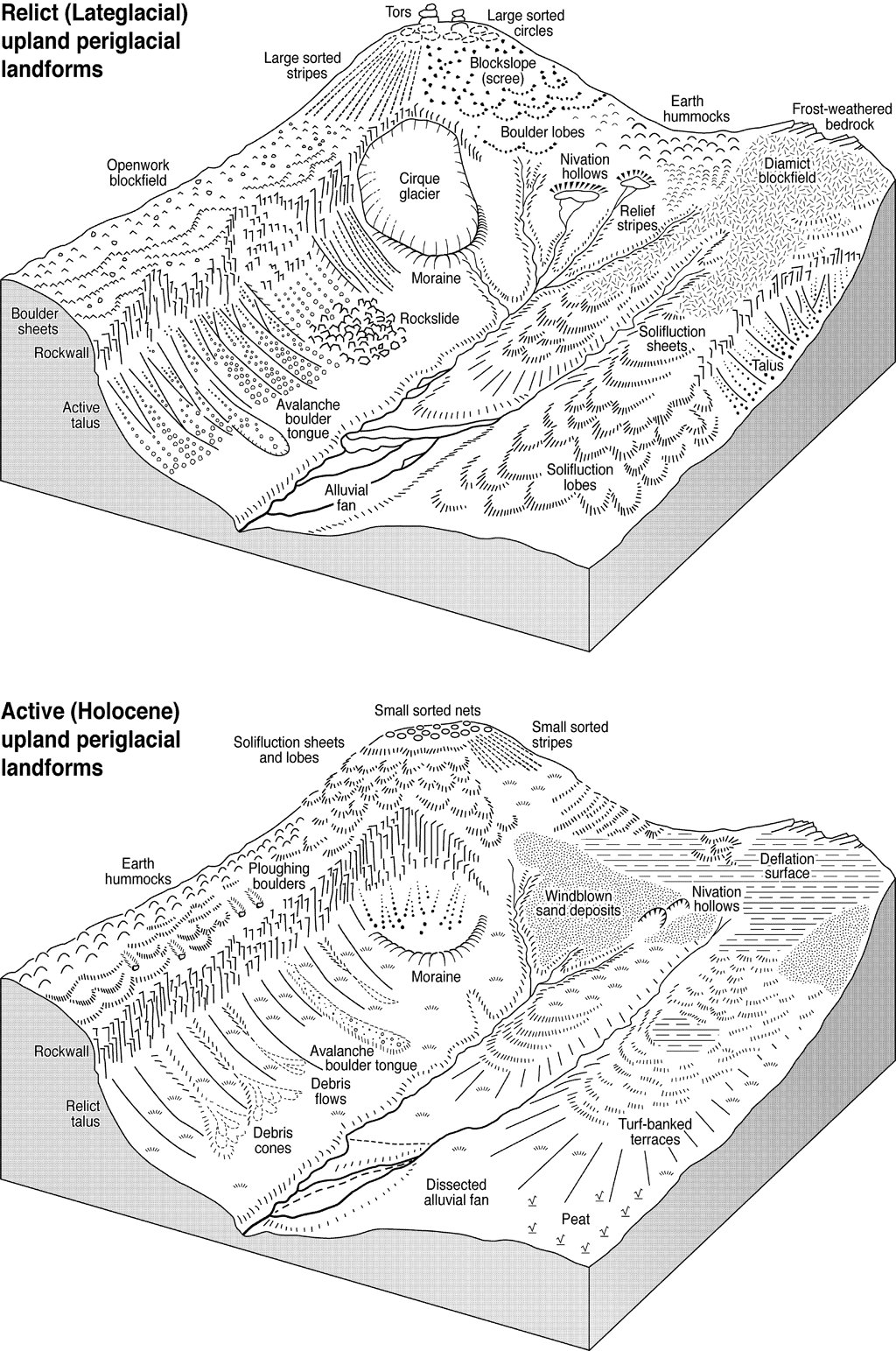
Research on the landform assemblages produced by Lateglacial periglacial processes operating on high ground in Scotland is summarised in Ballantyne (Reference Ballantyne1984) and Ballantyne & Harris (Reference Ballantyne and Benn1994). The account below focuses on more recent research. Figure 5a depicts the range of Lateglacial periglacial landforms on Scottish mountains.
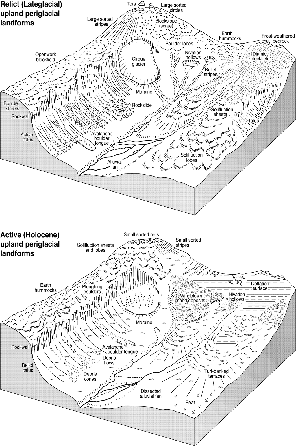
Figure 5 (a) Schematic illustration of periglacial and paraglacial landforms that developed on Scottish mountains during the Lateglacial period. (b) Schematic illustration of the range of Holocene (active) periglacial landforms on Scottish mountains. Because some landforms are restricted by regolith characteristics and hence by underlying lithology, the full range of Lateglacial or Holocene features is unlikely to be present on any single massif.
3.2.1. Blockfields and tors
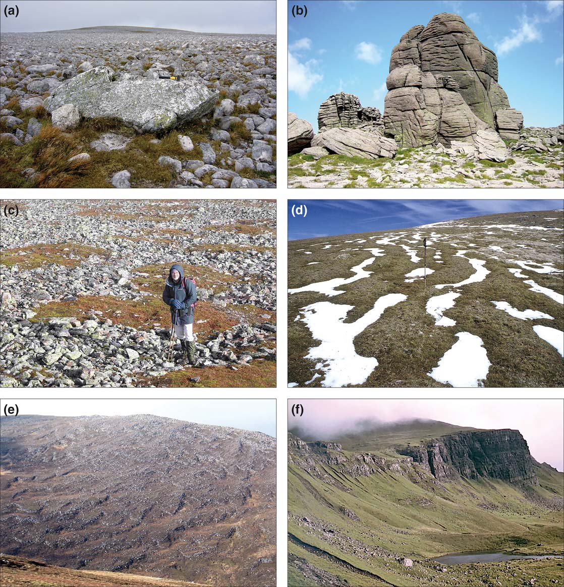
The higher parts of many Scottish mountains comprise undulating plateaux that represent the eroded relicts of uplifted palaeosurfaces (Hall Reference Hall1991; Goodfellow Reference Goodfellow2007). Such plateaux are extensive in the Eastern Grampians and the Southern Uplands, but have been fragmented by glacial dissection in the Western Highlands and the Hebrides. Plateaux and summits that escaped erosion by the last ice sheet are extensively mantled by blockfields (Fig. 6a), a term used here to denote all forms of bouldery plateau regolith. Studies of Scottish blockfields have shown that they developed primarily through frost weathering (Ballantyne Reference Ballantyne1998a, Reference Ballantyne2010b; Hopkinson & Ballantyne Reference Hopkinson and Ballantyne2014). Cosmogenic 10Be exposure dating of erratics resting on blockfield debris, however, has demonstrated that Scottish blockfields survived burial by the last ice sheet because the ice covering the plateaux was cold-based, frozen to the underlying substrate and hence moved through internal deformation alone, so that erosion by basal sliding did not occur (Fabel et al. Reference Fabel, Ballantyne and Xu2012). It follows that although renewed frost action probably modified Scottish blockfields during the Lateglacial, they are essentially much older landforms. The same is true of the tors that have gradually emerged from plateau surfaces through differential weathering and erosion of palaeosurfaces, usually because they have lower joint density than the surrounding terrain (Ballantyne Reference Ballantyne1994; Goodfellow et al. Reference Goodfellow, Skelton, Martel, Stroeven, Jansson and Hättestrand2014; Fig. 6b). Exposure dating of tors in the Cairngorms has demonstrated emergence since the Middle Pleistocene (∼920–130 ka), implying lowering of the surrounding palaeosurfaces by several metres to tens of metres during the last million years (Phillips et al. Reference Phillips, Hall, Mottram, Fifield and Sugden2006).

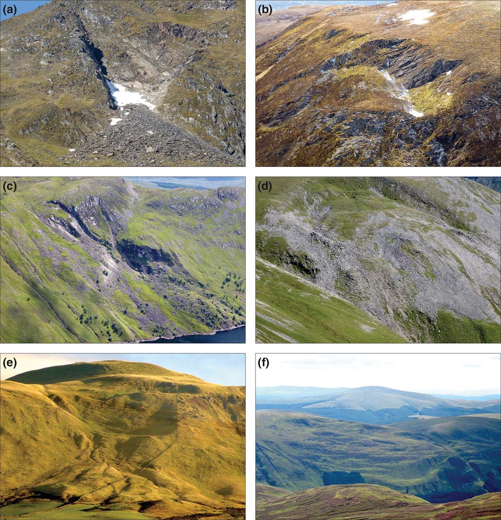
Figure 6 (a) Summit blockfield, Stob Bàn, NW Highlands. The large boulder is a quartzite erratic. (b) Tors at the summit of Beinn Mheadhoin, Cairngorms. The tor in the foreground is over 10 m high. (c) Large relict sorted circles, Glas Maol, SE Grampians. (d) Relict nonsorted relief stripes, Seana Braigh, NW Highlands. (e) Boulder lobes, Cairngorms. (f) Relict vegetated talus accumulations incised by debris flows, Trotternish, northern Skye.
3.2.2. Relict patterned ground and solifluction landforms
Plateau blockfields support relict sorted patterned ground features 1.5–4.5 m wide (Kelletat Reference Kelletat1970; Ballantyne & Harris Reference Ballantyne and Harris1994, pp 193–95). On low-gradient terrain, these take the form of circles of boulders that grade into sorted stripes on slopes (Fig. 6c). Pattern margins are defined by boulders occupying broad troughs; exposed clast surfaces are rounded by granular disaggregation whereas subsurface clasts are usually angular, a contrast that indicates prolonged stability. The vegetation-covered fine cells or stripes separated by these bouldery domains comprise soil with occasional clasts. The formation of such large-scale sorted patterns is now widely attributed to differential frost heave of clast-rich frost-susceptible soil, which initiates clast movement towards pattern borders, and a compensatory movement of soil at depth towards pattern centres (Ballantyne Reference Ballantyne, Elias and Mock2013b; Hallet Reference Hallet2013). Because such patterns form only in frost-susceptible soils, they are common on regolith derived from metamorphic rocks, but rare or absent on coarser grained lithologies (Ballantyne Reference Ballantyne1984). Sorted patterns exceeding 2 m in width usually indicate formation above permafrost. Although it is possible that bouldery patterned ground may have survived burial under cold-based ice, it is likely that the forms now visible were formed or reactivated under Lateglacial periglacial conditions.
Nonsorted vegetation-covered earth hummocks up to 0.5 m high and ∼2.0 m wide are also common on frost-susceptible regolith covers such as those of the Eastern Grampians, Ben Wyvis and higher summits in the Southern Uplands. On some plateau margins, hummocks grade into relief stripes (vegetated ridges and furrows aligned downslope) as the gradient steepens beyond 6–11° (Fig. 6d). Excavations through hummocks and relief stripes have shown that the horizons of podzols parallel the surface microtopography, implying prolonged stability, and it is likely that these landforms represent differential frost heave of relatively clast-poor soils during the Lateglacial period (Ballantyne Reference Ballantyne1986a).
Lateglacial mass movement has produced large terraces and lobes of coarse bouldery debris. These are best developed on granite mountains, though similar features occur on most metamorphic rocks. Terraces comprising 1–3 m-high bouldery risers and gently-sloping treads extend along slope crests for tens or hundreds of metres; with increasing gradient, terraces become crenulate in planform, and further downslope the over-riding of terraces has isolated individual boulder-fronted lobes (Fig. 6e). In the Cairngorms, boulder lobes extend downslope to 540 m, but are absent from all areas occupied by glacier ice during the YDS, implying that movement ceased with the onset of rapid warming at ∼11.7 ka. The mechanism responsible for the downslope movement of such coarse bouldery debris is uncertain. Some authors have suggested that boulder lobes and terraces represent downslope movement of debris by the creep of underlying ice-rich permafrost, analogous to the movement of coarse debris in rock glaciers (cf. Kääb & Kneisel Reference Kääb and Kneisel2006). An alternative explanation is that bouldery terraces and lobes are sorted solifluction landforms, similar to the ‘stone-banked lobes' investigated by Benedict (Reference Benedict1970), in which vertical and lateral frost sorting have resulted in concentration of coarse debris on the surface and margins, and that downslope movement resulted from solifluction of a buried core of finer sediment overlying permafrost. The morphological similarity of boulder terraces and lobes and active solifluction landforms (see section 4.1.1) suggests that the latter explanation is more plausible, particularly as there appear to be no present-day analogues for terrace and lobe formation by permafrost creep.
Vegetation-covered, nonsorted Lateglacial solifluction terraces and lobes are also present on Scottish hillslopes, particularly on schists, outside the limits of YDS glaciation. These are typically 1–2 m thick, are often best developed where the gradient lessens at slope-foot locations, and can be distinguished from their Holocene counterparts by degraded risers and the absence of buried soil horizons.
3.2.3. Talus, protalus ramparts and rock glaciers
The term ‘talus' describes aprons of rockfall debris that have accumulated below cliffs to form talus slopes comprising a quasi-rectilinear upper slope with a gradient of 33–39° and a basal concavity. Most taluses in Scotland are essentially relict, vegetated landforms and many exhibit evidence for erosion by streams, translational landslides and debris flows (Fig. 6f). Although talus deposits are dominated by coarse debris, fine (<2 mm) sediment constitutes 27–30 % by weight of the uppermost few metres of talus accumulations, and represents the granular weathering of source rockwalls, grainfall on to talus surfaces and the illuviation of fines within the talus body (Salt & Ballantyne Reference Salt and Ballantyne1997; Hinchliffe et al. Reference Hinchliffe, Ballantyne and Walden1998).
It is widely accepted that most talus accumulation in Scotland occurred during the Lateglacial, with a limited addition of rockfall debris during the Holocene. Taluses outside the limits of the LLR tend to be thicker, and to bury more of the source rockwall, than those inside these glacier limits, implying an enhanced rockfall during the Lateglacial (Ballantyne & Eckford Reference Ballantyne and Eckford1984; Kotarba Reference Kotarba1984). Enhanced rockfall during the Lateglacial is also implied by large lateral moraines at sites where LLR glaciers evacuated rockfall debris from cliffed source areas (Benn Reference Benn1989). High rates of rockfall activity during the Lateglacial have been attributed to joint propagation within cliffs due to paraglacial stress release, and frost wedging of jointed rockwalls under periglacial conditions (Hinchliffe & Ballantyne Reference Hinchliffe and Ballantyne2009). For talus below the Trotternish Escarpment on Skye, Hinchliffe & Ballantyne (Reference Hinchliffe and Ballantyne1999) estimated that ≥80 % of all rockwall retreat (and thus talus accumulation) occurred between ice-sheet deglaciation at ∼16.5 ka and the end of the Lateglacial. Curry & Morris (Reference Curry and Morris2004) subsequently applied a paraglacial exhaustion model to the Trotternish rockwall retreat rate data and similar data for two sites in Wales. This model suggests that ∼50 % of talus accumulation occurred within 1000 years following deglaciation, and that rates of accumulation were negligible after ∼5000 years, a proposition broadly supported by radiocarbon dating of buried soils within talus accumulations in NW Scotland (Hinchliffe & Ballantyne Reference Hinchliffe and Ballantyne2009).
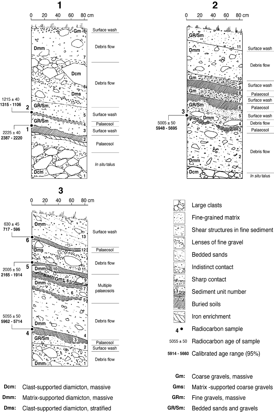
There is evidence that debris flow activity was also widespread during the Lateglacial. In a few areas, stratigraphic evidence suggests extensive reworking of glacigenic drift by debris flows during or immediately after deglaciation (Benn Reference Benn1992; Ballantyne & Benn Reference Ballantyne, Benn, Anderson and Brooks1996; Bennett Reference Bennett1999). Radiocarbon dating of buried organic horizons within debris cones deposited by successive debris flows extends no earlier than ∼7 ka, but the oldest dated horizons at some sites overlie up to 10 m of earlier debris-flow deposits, implying that flows of greater magnitude and/or frequency occurred during the Lateglacial or early Holocene. Evidence for debris transport by snow avalanches during the Lateglacial is more elusive. Relict avalanche boulder tongues occur at the foot of taluses in Glen Feshie (Cairngorms) and Glen Taitneach (SE Grampians), but their age is unknown. It seems likely that powerful snow avalanches were common under stadial conditions during the Lateglacial but, if so, the morphological signature of such events has probably been obliterated by Holocene debris flows (Luckman Reference Luckman1992).
Although several accounts of Lateglacial rock glaciers have been published (Harrison et al. Reference Harrison, Whalley and Anderson2008), a reinvestigation of putative rock glaciers suggests that most or all represent rockslide runout debris or drapes of glacially-deposited boulders (Ballantyne et al. Reference Ballantyne and Stone2009; Jarman et al. Reference Jarman, Wilson and Harrison2013); there appear to be no unequivocal examples of Lateglacial rock glaciers in Scotland. Similarly, some talus-foot debris accumulations originally interpreted as Lateglacial protalus ramparts (Ballantyne & Kirkbride Reference Ballantyne and Kirkbride1986) have subsequently been shown to represent arcuate rockslide deposits, formed where cascading debris impacted low-gradient terrain at the slope foot (Ballantyne & Stone Reference Ballantyne and Stone2009).
3.3. Lateglacial rock-slope failures
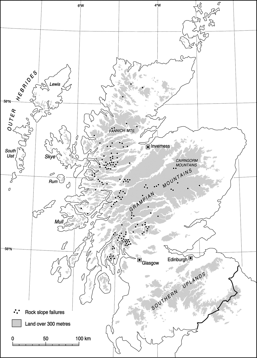
The term ‘rock-slope failure' (RSF) is here employed to encompass all types of downslope movement of large rock masses, including rockslides, toppling failures, large rockfalls and rock avalanches, as well as rock-slope deformations that involve the displacement of large rock masses without the release and runout of debris. Groundbreaking theses by Watters (Reference Watters1972) and Holmes (Reference Holmes1984) demonstrated that large postglacial RSFs are widespread on the metamorphic rocks of the Scottish Highlands, and a compilation of documentary evidence (Ballantyne Reference Ballantyne1986b) identified 625 Scottish RSFs, of which 564 are located in the Highlands and the Hebrides, 37 in the Midland Valley (mainly associated with scarps underlain by lavas and sills) and 24 in the Southern Uplands. Jarman (Reference Jarman2006, 2007) subsequently estimated that the Highlands alone contain over 550 RSFs, including 140 with areas >0.25 km2 (Fig. 7). The great majority of these are seated on metasedimentary rocks of the Moine and Dalradian Supergroups. Cave & Ballantyne (Reference Cave and Ballantyne2016) have shown that the concentration of RSFs on schists is significantly greater than that on other lithologies, irrespective of outcrop area.

Figure 7 Distribution of documented postglacial rock-slope failures >0.25 km2 in the Scottish Highlands, almost all of which occurred on schists. Large postglacial RSFs in the Southern Uplands and Hebrides are not included, nor are debris-free scarps from which runout debris was removed by glacier ice during the YDS. Adapted from Jarman, D. (Reference Jarman2006) Engineering Geology 83, 161–82, with permission from Elsevier.
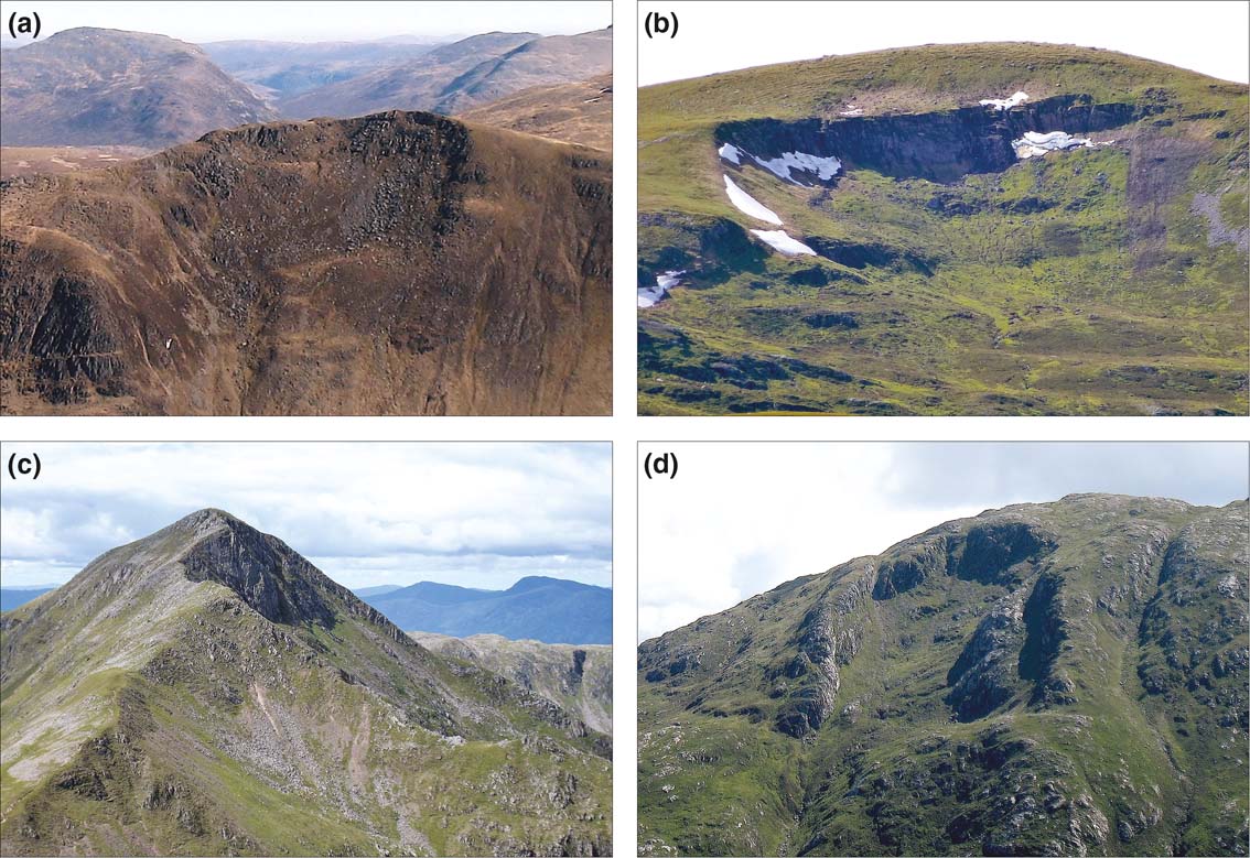
Catastrophic RSFs (slides, topples, rock avalanches and major rockfalls) tend to be characterised by headscarps and/or lateral scarps, a distinct failure plane and the downslope translocation of failed rock in the form of a coherent mass, large blocks of intact rock, an apron of runout debris or, more rarely, large debris-flow lobes (Fig. 8a–e). Rock-slope deformations involve a limited downslope displacement of largely intact rock masses; lateral margins are often indistinct and headscarps are not always present. Surface morphology is characterised by slope bulging, tension cracks near slope crests and arrays of antiscarps (uphill-facing scarps) aligned across-slope (Fig. 8f), and some exposures reveal flexural deformation and dislocation of bedding that extends tens of metres into the rock (Peacock & May Reference Peacock and May1993). Rock-slope deformations may involve the shift of entire mountainsides. The largest, on Beinn Fhada in Kintail, covers ∼3 km2 (Jarman & Ballantyne Reference Jarman and Ballantyne2002), and Jarman (Reference Jarman2006) identified 89 rock-slope deformations >0.25 km2 in area in the Scottish Highlands. He suggested that these can be subdivided into extensional and compressional types, but many exhibit extensional features on the upper slope and compressional features farther downslope.

Figure 8 Examples of postglacial rock-slope failures in Scotland: (a) recent rockslide and runout debris, Am Bodach, Mamore Mountains [NN 179649]; (b) arrested rockslide, Tom na Caillich, Northern Highlands [NH 440656]; (c) complex rockslide, Loch Ericht [NN 530687]; (d) arrested rockslide, Geal Charn, central Grampians [NN 468738]; (e) Hoglayers RSF and runout lobes, West Lomond Hill, Fife [NO 194071]; (f) large rock-slope deformation, Bell Crag, Tweedsmuir Hills, Southern Uplands [NT 181128].
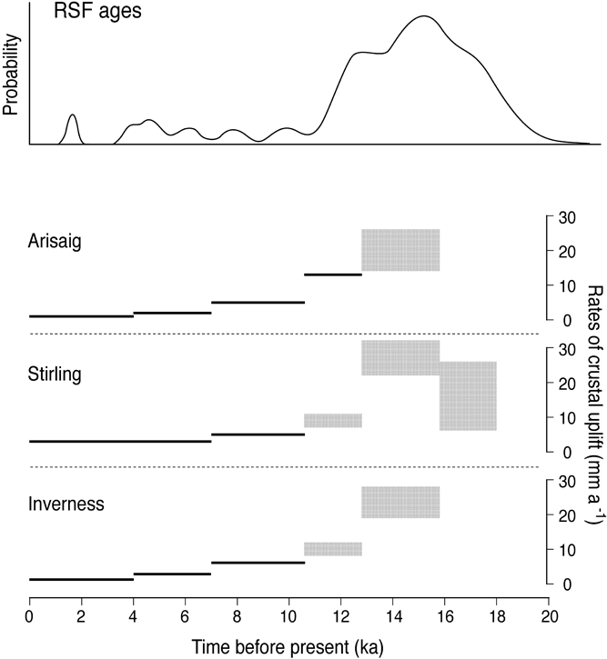
Dating of 31 catastrophic RSFs in the Scottish Highlands and NW Ireland using cosmogenic 10Be and 36Cl (Ballantyne & Stone Reference Ballantyne and Stone2013; Ballantyne et al. Reference Ballantyne, Sandeman, Stone and Wilson2014a, Reference Ballantyne, Wilson, Gheorghiu and Rodésb) has allowed the age of these features to be determined and has thrown light on the nature of triggering factors. Of 20 dated RSFs located outside the limit of the LLR, all but one occurred during the Lateglacial period, within ∼5.4 ka after local deglaciation, with peak RSF activity 1.6–1.7 ka after deglaciation (Fig. 9). Ballantyne et al. (Reference Ballantyne, Sandeman, Stone and Wilson2014a) inferred that this time lag represented a time-dependent reduction of rock-mass strength due to deglacial unloading, the development of stress-relief joints and an associated progressive development of a failure plane, leading either to spontaneous kinematic release or failure triggered by some extrinsic mechanism. Analysis of the timing of individual failures suggested that glacial debuttressing (removal of supporting glacier ice), enhanced water pressures during deglaciation or thaw of permafrost ice in rock joints could have triggered failure in only a small number of cases. Conversely, they demonstrated that the timing of maximum postglacial RSF activity was coincident with that of maximum rates of glacio-isostatic uplift (Fig. 10), suggesting that the two are linked by uplift-driven earthquake activity. A seismic failure trigger is consistent with full-slope failure at all sites where failure planes are clearly defined (cf. Densmore & Hovius Reference Densmore and Hovius2000), and with independent evidence of uplift-driven fault movements and palaeoseismicity during the Lateglacial period (Davenport & Ringrose Reference Davenport and Ringrose1987; Ringrose Reference Ringrose1989a, b; Firth & Stewart Reference Firth and Stewart2000; Stewart et al. Reference Stewart, Firth, Rust, Collins and Firth2001; Smith et al. Reference Smith, Stewart, Harrison and Firth2009). The timing of rock-slope deformations is unknown, although it seems likely that these also reflect rock mass weakening due to deglacial unloading, the realignment of the principal stress field and progressive brittle damage (static fatigue) leading to creep of mountain slopes.
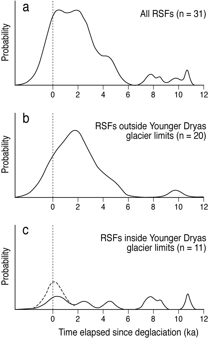
Figure 9 Summed normal kernel density estimates generated by 31 RSF ages from Scotland (22) and NW Ireland (9), calculated as time elapsed since deglaciation: (a) all RSFs; (b) RSFs outside the YDS glacier limits; (c) RSFs inside the YDS glacier limits. Extension of curves to the left of 0 ka is an artefact of curve generation. From Ballantyne et al. (Reference Ballantyne, Sandeman, Stone and Wilson2014a) Quaternary Science Reviews 86, 144–57. Reproduced with permission.
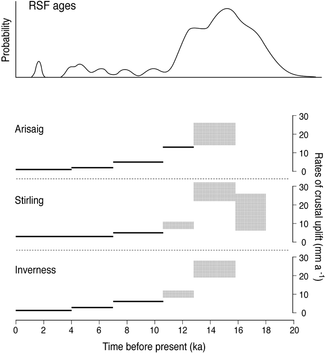
Figure 10 Summed normal kernel density estimates for 31 dated catastrophic RSFs in Scotland and NW Ireland plotted against rates of glacio-isostatic uplift for three coastal locations in Scotland. Crustal uplift data are from Firth & Stewart (Reference Firth and Stewart2000). From Ballantyne et al. (Reference Ballantyne, Sandeman, Stone and Wilson2014a) Quaternary Science Reviews 86, 144–57. Reproduced with permission.
As almost all dated catastrophic RSFs located outside the limits of the LLR occurred during the Lateglacial, it is inevitable that numerous RSFs also occurred within LLR glacial limits, but are less conspicuous because all runout debris has been removed by LLR glacier ice. The sites of such RSFs are marked by debris-free failure scarps, usually comprising a steep headscarp, a quasi-rectilinear or stepped failure plane and, in some locations, flank scarps, headscarp tension cracks and occasional in situ detached blocks near the headscarp (Ballantyne Reference Ballantyne2013c; Fig. 11). Survey of mountainous areas in NW Scotland and the Outer Hebrides has demonstrated that such debris-free scarps are widespread on slopes >25° and, like other RSF sites, are preferentially developed on schists (Cave & Ballantyne Reference Cave and Ballantyne2016). An implication of such debris-free scarps is that reworking of the debris deposited by numerous large-scale Lateglacial RSFs (and innumerable small valley-side RSFs) probably contributed significantly to the sediment transported by LLR glaciers, and thus to the volume of sediment contained within LLR moraines (Benn Reference Benn1989).

Figure 11 Examples of debris-free scarps representing the sites of Lateglacial rockslides from which debris was removed by glacier ice during the Loch Lomond Readvance: (a) Coire Sgrìodain, western Grampians [NN 355745]; (b) Coire Sron an Nid, central Grampians [NN 522772]; (c) Coire Sgréamhach, Sgorr Donuill, Western Grampians; (d) Coire Mhic Eacharna, Ardgour [NM 929634].
3.4. Lateglacial rivers
The floors of major valleys throughout Scotland are occupied by valley fills, generally a few metres to several tens of metres thick, that separate present floodplains from the underlying rockhead. They may be compositionally simple, as where alluvium directly overlies bedrock, or stratigraphically complex, where glacifluvial or alluvial sediments deposited during and after deglaciation overlie glacigenic deposits. Much of our understanding of Lateglacial fluvial activity in Scotland arises from studies of terrace sequences flanking present floodplains, and alluvial fans deposited at the junction of tributary valleys.
3.4.1. Lateglacial terrace sequences
Terraces bordering present floodplains are essentially erosional landforms produced by river incision of former channels or floodplains. In some cases, particularly in the western Highlands, postglacial river incision into bedrock has produced ‘strath terraces,' bedrock terraces that are sometimes overlain by a veneer of alluvium (see section 4.4.3 below). In others, generally in tributary valleys, rivers have cut down into glacigenic deposits, forming terraces underlain by till but capped by a thin cover of alluvial sediments representing the former level of the river. By far the most common Lateglacial terraces in major valleys, however, are those where glacifluvial deposits initially accumulated as sandar (braided outwash floodplains) that were then abandoned as a result of river incision.
Fluvial downcutting may be caused by either a drop in base level or a change in the balance between sediment supply and effective flood discharge. For rivers terminating at the coast, incision has been due to a lowering of relative sea level caused by glacio-isostatic uplift (e.g., Gray Reference Gray1975; Gray & Sutherland Reference Gray, Sutherland, Gray and Lowe1977; Tipping et al. Reference Tipping1994; Bishop et al. Reference Bishop, Hoey, Jansen and Lexartza Artza2005). Similarly, for rivers that drained into former ice-dammed lakes, a lowering of lake level has resulted in fluvial downcutting and terrace development (Sissons Reference Sissons1977, Reference Sissons1979a, Reference Sissons1982; Sissons & Cornish Reference Sissons and Cornish1983; Russell Reference Russell1995). More locally, where alluvial reaches terminate downvalley at a base-level represented by a bedrock reach, lowering of the bedrock channel by incision or knickpoint retreat has caused fluvial downcutting and terrace formation in the alluvial reach upstream (Young Reference Young1976). In upland valleys where valley fills are thin, multiple alluvial reaches are often separated by bedrock reaches that represent steps in the valley long profile produced by glacial erosion (Addy et al. Reference Addy, Soulsby and Hartley2014; Whitbread et al. Reference Whitbread, Jansen, Bishop and Attal2015).
Aggradation or incision of alluvial or outwash deposits also depends on sediment supply and dominant river discharge. When sediment supply exceeds the transport capacity of a river, floodplain (or sandur) aggradation occurs. In major valleys, this situation was common during and immediately after ice-sheet deglaciation, when glacigenic sediments and those supplied by paraglacial hillslope processes were entrained by proglacial rivers and deposited on valley floors vacated by the retreating ice (Gray & Sutherland Reference Gray, Sutherland, Gray and Lowe1977; Young Reference Young1978; Aitken Reference Aitken1998; Marren Reference Marren2001). Subsequent reduction in proglacial and paraglacial sediment supply, however, has resulted in rivers cutting deeply into earlier outwash or alluvial deposits, leaving abandoned sandur or floodplain surfaces as terraces. Owing to fluctuations in both sediment supply and river discharge under the rapidly changing climate of the Lateglacial period (Fig. 2), it is possible that some valleys experienced two or more cycles of aggradation and incision, but the limited stratigraphic evidence available supports only a single cycle of initial sediment aggradation, followed by pulsed or continuous incision (Aitken Reference Aitken1998; Marren Reference Marren2001).
Scottish Lateglacial terraces fall into four categories: (1) kame terraces, formed by deposition of sediment by rivers at the lateral margins of glaciers, and abandoned during subsequent glacier thinning and retreat; (2) proglacial outwash terraces representing the remnants of former sandar; (3) alluvial terraces, representing the former floodplains of nonglacial rivers; and (4) river terraces associated with former ice-dammed lakes.
3.4.1.1. Kame terraces
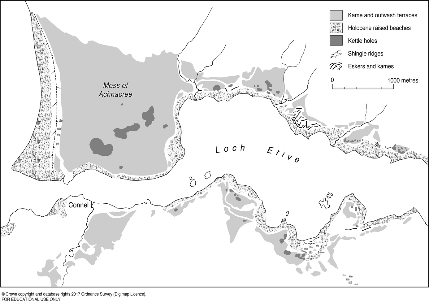
Kame terraces formed during both the later stages of ice-sheet retreat (∼17–15 ka) and the YDS (∼12.9–11.7 ka). They are often perched on hillslopes tens or even hundreds of metres above present floodplains, may contain kettle holes formed through melt of buried ice blocks and are frequently associated with ice-marginal meltwater channels. Kame terraces that formed at the margins of the last ice sheet are abundant along the flanks of Strathspey and the Dulnain valley (Young Reference Young1977, Reference Young1978) and the northern slopes of the Cairngorms, where the most extensive represent sediment infill of former ice-marginal lakes (Brazier et al. Reference Brazier, Whittington and Ballantyne1998; Everest & Kubik Reference Everest and Kubik2006; Hall et al. Reference Hall, Binnie, Sugden, Dunai and Wood2016). High-level kame terrace fragments are also associated with ice-marginal meltwater channels in the upper Clyde, Annan and Tweed valleys of the Southern Uplands. Locally, an upper sequence of kame terraces may be succeeded downslope by terraces of other types. In the Streens Gorge in Strathdearn, for example, terrace fragments at 13 levels occur up to 80 m above the floodplain of the River Findhorn. Auton (Reference Auton, Auton, Firth and Merritt1990) interpreted most of the higher benches as kame terraces, an intermediate terrace as a delta formed in an ice-marginal lake and the lowermost five terraces, 10–30 m above the present floodplain, as outwash or alluvial terraces. Kame terraces of YDS age formed along the lower margins of some outlet glaciers, for example in Glen Moriston (Sissons Reference Sissons1977) and along the shores of Loch Etive, where kettled kame terraces up to 400 m wide merge with a large kettled outwash terrace graded to a Lateglacial sea level of 10–12 m OD (Gray Reference Gray1975; Fig. 12).

Figure 12 Kettled kame terraces formed at the margin of a YDS glacier merging westward into a large kettled outwash terrace (Moss of Achnacree), graded to a Lateglacial sea level of 10–12 m above present at the mouth of Loch Etive. Adapted from Gray, J. M. (Reference Gray1975) Proceedings of the Geologists' Association 86, 227–38.
3.4.1.2. Outwash terraces
As argued by Sissons (Reference Sissons1982), the great majority of terraces bordering the floodplains of major rivers throughout Scotland are probably outwash terraces that represent abandoned proglacial sandur surfaces. Such terraces typically extend up to 30 m above present floodplains (and occasionally higher) and support a microtopography of braided palaeochannels. Some are pitted with kettle holes, confirming a glacifluvial origin (Fig. 12). Most outwash terraces are largely or entirely composed of glacifluvial sands and gravels (Rhind Reference Rhind1969; Robertson-Rintoul Reference Robertson-Rintoul1986; Maizels & Aitken Reference Maizels, Aitken, Starkel, Gregory and Thornes1991; Russell Reference Russell1995; Aitken Reference Aitken1998; Marren Reference Marren2001), implying that an initial phase of net glacifluvial sediment aggradation preceded net incision and terrace formation. There is, however, a marked contrast between the outwash terraces deposited during the retreat of the last ice sheet, which often rise 5–40 m above present floodplains (Fig. 13), and terrace heights in valleys formerly occupied by LLR glaciers. With the exception of LLR outwash terraces graded to high Lateglacial sea levels (Fig. 12), or to the levels of former ice-dammed lakes, the highest terraces inside LLR ice limits rarely occur more than a few metres above present river channels, and the limited dating evidence suggests that at least some these are of late Holocene age (see section 4.4.1.1 below). One possible explanation for the apparent lack of LLR outwash terraces in Highland glens is that glacier retreat during the YDS generated high effective discharges, resulting in net incision rather than aggradation of proglacial sandar.
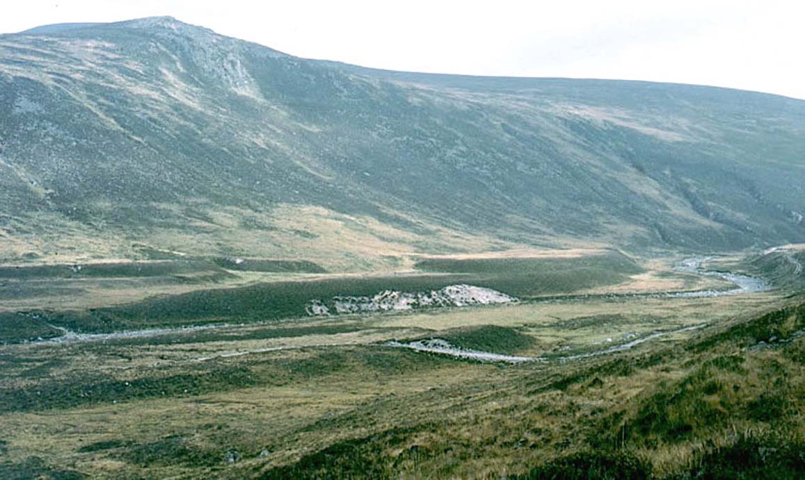
Figure 13 Terraces in Glen Dee, Cairngorms. The higher terraces rise over 10 m above the present floodplain, and represent postglacial incision of outwash deposited during glacier retreat around ∼16.5–15.5 ka. The low terrace adjacent to the present floodplain is probably late Holocene in age.
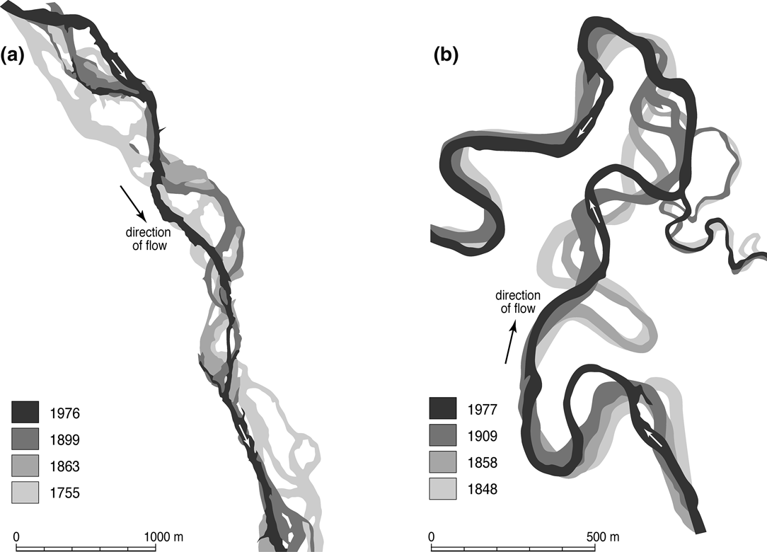
Maizels (Reference Maizels1983a, Reference Maizelsb) identified a sequence of four or five prominent outwash terraces bordering the floodplains of rivers draining eastwards from the Highland edge, all of which she attributed to the period of ice-sheet deglaciation. She speculated that each terrace could represent aggradation associated with brief readvances of the retreating ice margin and incision during ensuing ice-margin retreat, but there is no stratigraphic evidence supporting this view. The terraces are undated and contemporaneity of terraces between glens is uncertain. Focusing on an area of extensive development at the confluence of the North Esk and West Water near Edzell, she showed that although all terraces support braided palaeochannels, the degree of braiding declines from the uppermost (oldest) to lowest (youngest) terrace, accompanied by increase in sinuosity, changes that may reflect progressive establishment of a more stable channel system. Exposures in one terrace revealed massive, poorly-sorted imbricate gravels and cobbles with lenses of cross-bedded and plain-bedded sand, a lithofacies assemblage typical of an aggrading proglacial braided sandur. Palaeodischarges calculated by Maizels & Aitken (Reference Maizels, Aitken, Starkel, Gregory and Thornes1991) on the basis of channel dimensions, and the calibre of bed material suggested declining maximum discharges from ∼18,000 m3 s–1 to ∼7000 m3 s–1, which they related to progressive reduction in glacier ice cover in the catchments. As they acknowledged, however, there is large uncertainty in calibration of palaeodischarge modelling parameters, which can lead to widely different estimates spanning two orders of magnitude (Church et al. Reference Church, Wolcott and Maizels1990).
From logging and analysis of terrace deposits in the Don valley upvalley from Aberdeen, Aitken (Reference Aitken1998) showed that these are characteristic of uninterrupted aggradation of proximal and distal braided outwash deposits, both lithofacies being interbedded with horizontal overbank sheetflow deposits. More locally, exposures in gravel pits have revealed a more complex lithostratigraphy that includes evidence of ice-marginal deltaic sediments capped by a proximal braided outwash sequence (Aitken Reference Aitken1995). The presence of numerous ice wedge pseudomorphs in the outwash deposits demonstrates that sandur aggradation occurred under permafrost conditions. Similarly, detailed analysis of palaeosandur deposits in the Lunan valley and Fife led Marren (Reference Marren2001) to conclude that these represent rapid aggradation during meltwater pulses associated with ablation-controlled discharges from glacier sources. Both studies imply that the development of outwash terraces was characterised by an initial aggradational phase during deglaciation, terminated by reduction in sediment supply and the onset of incision and terrace formation, rather than a more complex scenario involving multiple cycles of aggradation and trenching.
Outwash terrace sequences have also been reconstructed through mapping, survey and construction of height-distance diagrams that follow the valley long profile. Gray & Sutherland (Reference Gray, Sutherland, Gray and Lowe1977) used this approach to establish a relationship between former ice limits, outwash terraces and high (>30 m) Lateglacial sea levels at various sites in the Western Highlands, demonstrating thereby that the ice limits were asynchronous and linked to ice-sheet retreat rather than a later readvance. A similar approach was adopted by Young (Reference Young1976) to analyse terrace sequences in Glen Feshie. From a large number of surveyed terrace fragments, he identified five groups, all of which support braided palaeochannels. The uppermost three groups (1–3) begin in the central section of the glen, 25–40 m above the river, and decline steeply northwards towards a bedrock reach near the mouth of the glen; the highest and oldest terraces (groups 1 and 2) are locally kettled, confirming a glacifluvial origin. By contrast, the lowermost two groups (4 and 5) are present almost continuously throughout the length of the valley, roughly parallel to, and less than 5 m above, the present floodplain. Young's interpretation of the highest terraces is ambiguous: he described them both as kame terraces (implying an ice-marginal origin) but also (p. 509) as representing “an initial floodplain up to 1700 m wide” (implying a proglacial origin). The abrupt up-valley termination of the high terraces of groups 1–3 he attributed to removal by later erosion, ignoring the possibility that glacier ice may have still occupied the upper valley throughout the period of higher terrace formation (cf. Gray & Sutherland Reference Gray, Sutherland, Gray and Lowe1977). A radiocarbon age of 4.1–3.9 cal 14C ka obtained for charcoal fragments within an organic-rich layer buried by gravels within a low-level terrace (Robertson-Rintoul Reference Robertson-Rintoul1986) suggests that most or all of the low terraces in Glen Feshie are of late Holocene age. On the basis of soil-stratigraphic comparisons and assumed deglaciation ages, Robertson-Rintoul suggested that older terrace surfaces formed at ∼13 14C ka BP and ∼10 14C ka BP (∼15.6 cal 14C ka and ∼11.6 cal 14C ka). The former age is reasonably consistent with evidence for the timing of deglaciation of upper Strathspey (Ballantyne & Small Reference Ballantyne and Small2018 – this volume); the latter implies terrace formation at the time of the Lateglacial–Holocene transition.
3.4.1.3. Lateglacial alluvial terraces
There is a remarkable lack of evidence concerning the behaviour of nonglacial rivers during the Lateglacial Interstade (∼14.7–12.9 ka) and the YDS (∼12.9–11.7 ka; Fig. 2). Lewin & Macklin (Reference Lewin and Macklin2003) have suggested that floodplain incision was dominant during the Lateglacial Interstade and if so it is unlikely that evidence is preserved in alluvial archives. They also asserted that the YDS witnessed major renewed floodplain aggradation, contending that “alluvial units of this period are common in both upland and lowland” and that the early Holocene was dominated by floodplain incision, allowing preservation of YDS alluvial units and terrace fragments. The only dated evidence for floodplain aggradation in Scotland during the YDS comes from the Kelvin valley, where cores record floodplain deposits overlain by peat then an upper layer of (Holocene) floodplain deposits (Tipping et al. Reference Tipping, Jones, Carter, Holden and Cressey2008). The three oldest radiocarbon ages obtained for the base of the peat (11.7–11.4 cal 14C ka, 11.6–11.3 cal 14C ka and 11.2–10.8 cal 14C ka) imply that the underlying alluvium is of YDS age, possibly indicating floodplain aggradation at that time.
3.4.1.4. River terraces associated with former lakes
During ice-sheet deglaciation, retreat of ice from some tributary valleys was succeeded by formation of lakes dammed by glacier ice occupying trunk valleys (e.g., Aitken Reference Aitken1990; Brazier et al. Reference Brazier, Kirkbride and Gordon1998; Everest & Kubik Reference Everest and Kubik2006), and terraces formed upvalley from such lakes are related to former lake levels. Outwash and alluvial terraces in the Ochil Hills, for example, have been shown by Russell (Reference Russell1995) to relate to successive levels of a large lake in Glen Devon that was dammed by ice in the Forth Valley. The best-documented examples of glacier-lake-related terraces, however, are those associated with lakes dammed by ice during the LLR. From height–distance diagrams derived from survey of terrace fragments in upper Glen Doe and near Achnasheen, Sissons (Reference Sissons1977, Reference Sissons1982) demonstrated that all but the lowest terraces relate to successive levels of former ice-dammed lakes. A similar approach allowed him to demonstrate that the altitudes of numerous fluvial terraces in Glen Spean were controlled by successive levels of an ice-dammed lake in the lower glen, and after lake drainage by the elevated level of Loch Lochy (Sissons Reference Sissons1979a). His 1982 paper on the Achnasheen terraces contains a summary of features that distinguish glacier-lake-related fluvial terraces, such as abrupt downvalley termination, abnormally steep gradients related to abruptly falling lake levels, and a tendency for terrace convergence and divergence downvalley. Sites of former ice-dammed lakes also contain Lateglacial or early Holocene terrace sequences formed where rivers have incised the former lake floor. In upper Glen Roy, for example, the River Roy has incised the former bed of a sequence of proglacial lakes that formed during the YDS to form a complex sequence of terraces and bluffs (Sissons & Cornish Reference Sissons and Cornish1983; Fig. 14b).
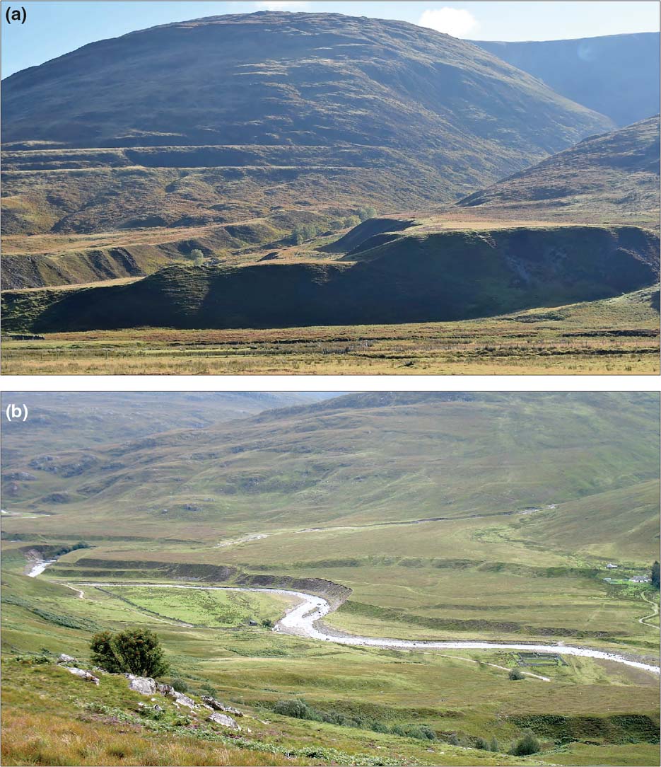
Figure 14 Lateglacial alluvial fans in Glen Roy: (a) the Brunachan fan, showing later terraces inset into the original fan and the two highest lake shorelines (at 325 m and 350 m OD) in the background; (b) the Annat fan in upper Glen Roy, showing how terraces formed by incision of the River Roy have cut back into the distal part of the original fan.
A unique lake-related terrace, the Auchteraw terrace near Fort Augustus, was interpreted by Sissons (Reference Sissons1979b) as an outwash terrace deposited by a jökulhlaup (catastrophic drainage) of a lake dammed at 261 m OD by glacier ice in lower Glen Spean. He calculated that this lake had a volume of ∼5 km3 and used an empirically-derived relationship based on recent jökulhlaup events to retrodict a possible maximum discharge of 22,500 m3 s–1 during lake drainage. The Auchteraw terrace, which lies inside the LLR glacial limit and hence formed after the onset of glacier retreat, is a massive accumulation of predominantly coarse sediment, ∼3 km long, ∼1 km wide and 12–16 m thick. Russell & Marren (Reference Russell and Marren1998) have shown that the lithofacies and surface morphology of the terrace are consistent with Sissons' interpretation, and Russell et al. (Reference Russell, Tweed and Harris2003) reported evidence of repeated episodes of high-energy deposition in terraced deposits near Spean Bridge, which they interpreted as evidence of later jökulhlaup floods that drained SW towards Loch Linnhe.
3.4.2. Lateglacial alluvial fans
Lateglacial alluvial fans are widespread throughout Scotland at the confluences of tributary streams with trunk valleys. In upland areas, fans deposited at the mouths of steep valleys form conspicuous sediment accumulations with surface gradients up to 10–12°; the steepest fans sometimes support bouldery lobes and levées, implying deposition by both flood torrents and channelised debris flows. Large, low-gradient fans occur at the confluences of major upland rivers, such as the Feshie and the Spey (Werritty & McEwen Reference Werritty, McEwen and Gregory1997). Lateglacial alluvial fans also occur in lowland areas (e.g., Auton & Crofts Reference Auton and Crofts1986), but are poorly documented. The largest fans, for example in Glen Roy and Glen Banchor, span >1500 m at their distal ends (Young Reference Young1978; Cornish Reference Cornish2017). The Lateglacial age of most fans is attested by morphostratigraphy: they commonly terminate on or merge with high-level outwash terraces, indicating contemporaneity (Young Reference Young1976, Reference Young1978). Subsequent incision of outwash deposits has caused trenching of fans by their parent streams, and formation of nested fans or inset terraces that often merge with lower outwash or alluvial terraces (Fig. 14).
Some Lateglacial fans, such as the Lindores fan in Fife (Marren Reference Marren2001) or the Hillhead fan near Dyce (Aitken Reference Aitken1998), were fed by glacial meltwater, and should strictly be regarded as outwash fans, as should kettled fans such as that at the Tromie–Spey confluence (Young Reference Young1978). Most Lateglacial fans at the mouths of steep valleys are probably paraglacial landforms, however, fed by fluvial reworking of glacigenic sediments after ice sheet deglaciation. During this period, when sediment supplies were abundant, recurrent avulsion (channel switching) on fan surfaces accompanied rapid fan aggradation to produce lobate deposits that typically fine down-fan (Brazier Reference Brazier1987), and fan surfaces abandoned as a result of river incision often exhibit a complex pattern of palaeochannels. An outstanding example is the Allt Fheargenau fan in Glen Feshie (Werritty & McEwen Reference Werritty, McEwen and Gregory1997), which merges with the highest outwash terrace fragments and was probably deposited shortly after local deglaciation at ∼16.5–15.5 ka. As with outwash terraces (see section 3.4.1.2 above), there are marked contrasts in fan development inside and outside the limits of the LLR, fans inside these limits being generally much smaller (Brazier Reference Brazier1987). This contrast suggests that readily-entrainable glacigenic sediments in fan catchments were largely depleted after ice-sheet deglaciation, so that paraglacial fans deposited on valley floors vacated by retreating LLR glaciers were sediment-limited.
Much of the literature on Lateglacial fans focuses on those in Glen Roy, where shorelines along valley-side slopes record the former existence of a sequence of lakes (at 261 m, 325 m and 350 m) that were dammed by glacier ice during the LLR (Fig. 14). This glen contains some of the largest valley-side fans in Scotland, but their origin has proved controversial. From the lithostratigraphy of three fans, Peacock (Reference Peacock1986) inferred that these are paraglacial landforms that accumulated during the Lateglacial Interstade (∼14.7–12.9 ka). A fourth fan, the Turret fan, was interpreted by Sissons & Cornish (Reference Sissons and Cornish1983) as an ice-proximal outwash fan deposited in the lowest (261 m) lake, but reinterpreted by Peacock (Reference Peacock1986) as an older landform that formed during ice-sheet retreat. Cornish (Reference Cornish2017) reinvestigated several of the Glen Roy fans and identified a consistent threefold stratigraphy comprising lacustrine sediments underlain by thick (>20 m) gravels and overlain by a thin gravel cap. He proposed that the lower gravels represent deposition in shallow water during the rising lake sequence, followed by deposition of lacustrine sediments as lake levels rose higher and finally subaerial deposition of gravels as lake levels fell. Absence of foreset beds and Gilbert-type deltas was attributed by Cornish to deposition in shallow water, and the thickness of the gravel beds led him to infer that LLR glaciers were probably present in fan catchments, implying that the fans are essentially sublacustrine outwash fans rather than paraglacial fans. The origin of the Turret fan remains controversial: some authors favour the original LLR ice-contact interpretation (Cornish Reference Cornish2017; Lowe et al. Reference Lowe, Palmer, Carter-Champion, Macleod, Ramirez-Rojas and Timms2017; Palmer & Lowe Reference Lowe, Palmer, Carter-Champion, Macleod, Ramirez-Rojas and Timms2017) whilst others have argued that LLR glacier ice failed to reach the proximal end of the fan and that it represents pre-YDS deposition (Boston & Lukas Reference Boston and Lukas2017). Floodplain incision after drainage of the 261-m lake (Sissons & Cornish Reference Sissons and Cornish1983) and reduction in sediment supply has resulted in trenching of the Glen Roy Fans, producing inset terraces and distal bluffs (Fig. 14).
4. Holocene landscape evolution
4.1. Holocene periglacial environments on high ground
It is likely that the present maritime periglacial conditions on high plateaux and summits in Scotland are reasonably representative of conditions throughout most of the Holocene. The present climate of ground above 700–800 m is characterised by shallow ground freezing, extreme wetness and strong, gusty winds (Ballantyne Reference Ballantyne and Boardman1987). Mean annual air temperatures exceed 0°C even on the highest summits, and air temperatures below −10°C are infrequent. Permafrost is absent, though seasonal ground freezing may reach depths of 0.4–0.5 m in shaded sites. All but the most easterly summits receive >2000 mm a–1 precipitation, with some summits in the Western Highlands receiving >4000 mm a–1. During much of the last century, average snow-lie (≥50 % cover) exceeded 100 days per year at 600 m altitude and 150–180 days per year at 900 m, although in recent years snow has been less persistent. Scottish mountains support a wide range of active periglacial features (Fig. 5b), most or all of which have probably been present throughout the Holocene.
4.1.1. Holocene frost weathering, patterned ground and solifluction features
Glacially-moulded bedrock surfaces on high ground exhibit only superficial evidence of clast detachment, suggesting that frost wedging or frost shattering of bedrock has been limited during the Holocene. Conversely, many exposed bedrock and clast surfaces are subangular to rounded (Fig. 15a), implying the operation of granular disaggregation by frost. The widespread occurrence of high-level aeolian deposits and aeolisols (see section 4.1.2) suggests that granular weathering of bedrock and clasts has persisted throughout the Holocene.
Active frost-sorted patterned ground features (circles, nets and stripes) on Scottish mountains rarely exceed 0.7 m in width, are restricted to unvegetated, frost-susceptible soils, and have been produced by lateral sorting of small (<15 cm long) clasts into shallow troughs 5–20 cm deep. The main sorting process is differential growth of needle-ice crystals during periods of shallow, often nocturnal, ground freezing (Ballantyne Reference Ballantyne1996), and miniature sorted patterns occur both on high ground and (more rarely) on unvegetated soil at low altitudes. The most impressive active sorted patterns are the stone stripes at ∼640 m on the felsite regolith of Tinto Hill in the Southern Uplands (Fig. 15b). Well-developed sorted stripes re-form on dug-over ground at this site within one to three winters, and painted clasts on stripes have moved downslope through needle-ice creep on a gradient of 23° at rates of 243–620 mm a–1 (Ballantyne Reference Ballantyne2001a).
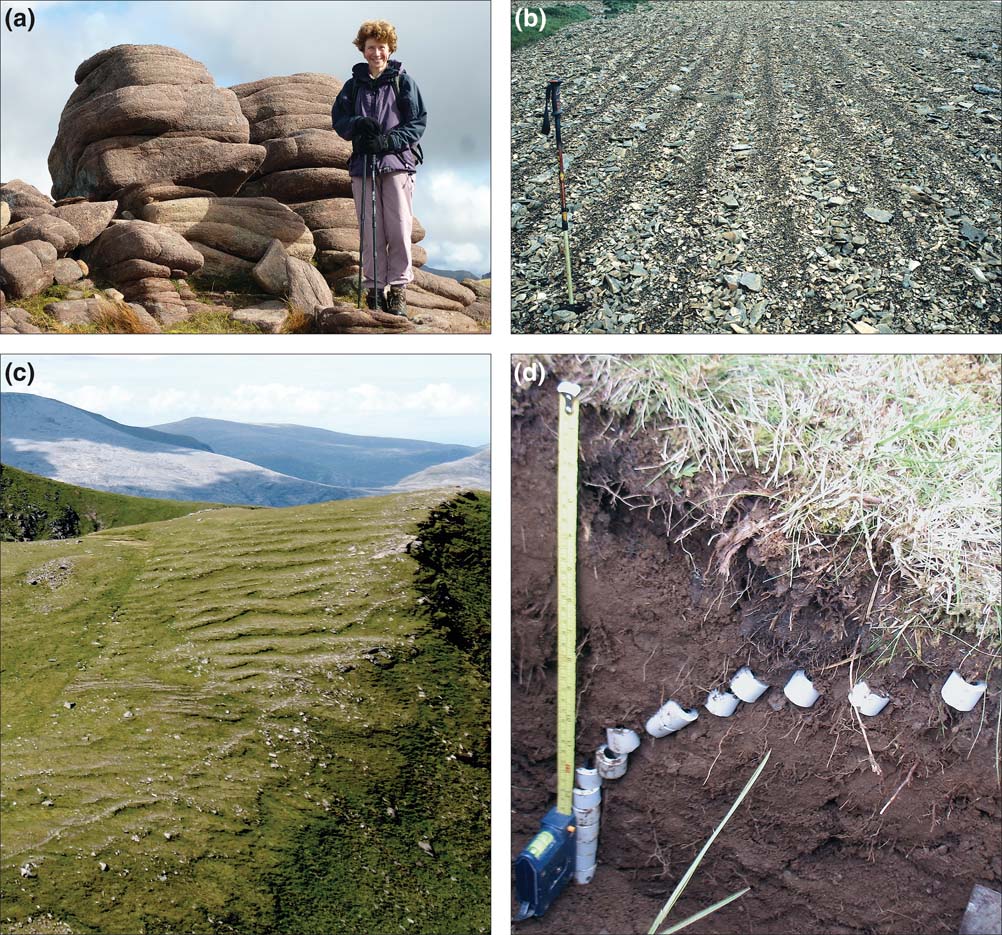
Figure 15 (a) Summit outcrop of Torridon Sandstone rounded by granular disaggregation, Beinn Dearg, Torridon. (b) Active sorted stripes, Tinto Hill, Southern Uplands. (c) Active solifluction terraces, Tom a' Choinnich, Fannich Mountains, NW Highlands. (d) Displacement of segmented columns by solifluction over 35 years, Fannich Mountains, NW Highlands.
Holocene solifluction landforms are widespread on many mountains above 550–600 m, particularly on schists that have weathered to produce frost-susceptible soils. On gentle to moderate slopes, these take the form of flights of vegetated solifluction terraces that terminate downslope at steep risers 0.2–1.0 m high (Fig. 15c). On steeper slopes, the risers take the form of a series of solifluction lobes arrayed across the slope. Although morphologically similar to relict solifluction landforms, active terraces and lobes have lower but steeper (sometimes bulging) risers, and often overlie organic soil horizons that have been buried by downslope movement of soil. Radiocarbon dating of buried organic matter has demonstrated movement of solifluction lobes over at least the past 5500 years (Sugden Reference Sugden1971; Mottershead Reference Mottershead1978) and segmented tubes installed in three lobes on the Fannich Mountains and excavated after 35 years indicated average surface velocities of 7.8–10.6 mm a–1, declining exponentially to zero at depths of 29–45 cm (Ballantyne Reference Ballantyne2013d; Fig. 15d). There is also evidence that lobes periodically rupture, burying the soil downslope under liquefied soil and debris. Five 14C ages obtained from soil buried under a solifluction lobe in the Fannich Mountains produced ages ranging from 890±120 14C a BP to 530±90 14C a BP (900±200 cal 14C a to 550±170 cal 14C a), statistically indistinguishable from that (660±70 14C a BP or 680±100 cal 14C a) of the same soil horizon immediately downslope (Ballantyne Reference Ballantyne1986c), thus suggesting almost instantaneous soil burial. It seems likely that lobe development involves a cycle of slow thickening and steepening of risers terminated by infrequent frontal rupturing, deposition of sediment a few metres downslope, then renewed slow thickening through solifluction (cf. Kinnaird & Lewkowicz Reference Kinnard and Lewkowicz2006).
Intimately associated with active solifluction terraces and lobes are ploughing boulders, which have moved downslope faster than the surrounding soil, leaving a vegetated furrow upslope and sometimes pushing up a ridge of soil downslope. Most occur on vegetated slopes of 8–30°, and recent activity is indicated by a niche that extends to the base of the boulder at its upslope end. Averaged rates of recent boulder movement range from 1.5–7.0 mm a–1 on the Drumochter Hills and 0.3–8.7 mm a–1 on Lochnagar, to 3.6–30.3 mm a–1 on the Fannich Mountains (Ballantyne Reference Ballantyne2001b). Boulder movement has been attributed to ice lens formation under boulders during seasonal freezing and consequent generation of high pore-water pressures at the base of boulders during thaw, allowing them to slide downslope over softened or liquefied soil (Wilson Reference Wilson1993; Ballantyne Reference Ballantyne2001b).
4.1.2. Holocene aeolian landforms and deposits on high ground
The strong winds that sweep across high ground in Scotland have produced a wide range of distinctive landforms. Wind-driven sand particles have abraded boulders on some lithologies producing ventifacts that display distinctive facetted, fluted, pitted and polished surfaces (Christiansen Reference Christiansen2004), and the interaction of wind stress, frost action and vegetation cover has produced a range of aeolian microforms on exposed plateaux and high cols. This includes isolated deflation scars, wind stripes (straight or wavy lines of vegetation alternating with bare ground) and wind crescents, arcuate clumps of vegetation that slowly migrate downwind across bare ground (Bayfield Reference Bayfield1984; Fig. 16a). On higher slopes, turf-banked terraces with unvegetated treads and vegetated risers extend horizontally or obliquely across the slope. The evolution of these features is uncertain, but probably attributable to the formation of wind stripes that retard downslope movement of soil by solifluction (Ballantyne & Harris Reference Ballantyne and Harris1994).

Figure 16 Holocene aeolian landforms on high ground: (a) wind stripes on Beinn a'Bhach-Ard, NW Highlands; (b) deflation surface and residual island of eroding windblown sand, Ward Hill, Orkney; (c) pit excavated through aeolian deposits 2.9 m deep on the summit of The Storr, Trotternish, Skye; (d) section through plateau-margin aeolian sands, An Teallach, showing unweathered upper unit sand overlying a lower weathered sand unit; the boundary lies between the two circular holes, from which samples for OSL dating were extracted.
The most extensive products of wind erosion are deflation surfaces, expanses of bare ground where stripping of vegetation cover has exposed the soil to wind scour that has winnowed away particles up to 4–6 mm in diameter, leaving a sterile surface carpeted by boulders and a gravel lag. Superb examples occur on granite and sandstone mountains, but deflation surfaces occur on all lithologies and are present as low as 350 m in Orkney and Shetland. In some locations, vegetated ‘islands' of aeolian sand deposits or aeolisols are present, demonstrating that sand or soil cover was formerly more extensive (Birse Reference Birse1980; Ballantyne & Morrocco Reference Ballantyne and Morrocco2006; Fig. 16b). A few plateaux support a more extensive mantle of aeolian sediment, preserved under vegetation cover. A remarkable example of intact aeolian deposits up to 2.9 m thick occurs on the summit of The Storr (719 m) in northern Skye (Fig. 16c), immediately above basalt cliffs exposed by a rockslide at 6.1±0.5 ka (Ballantyne et al. Reference Ballantyne, Stone and Fifield1998). The aeolian deposits thin away from the plateau edge, and radiocarbon dating of buried soils shows that the onset of aeolian deposition coincided with exposure of the rockwall, indicating that the aeolian deposits represent grains released from the rockwall by weathering and blown upwards on to the plateau, where they were anchored by vegetation cover (Ballantyne Reference Ballantyne1998b). Other plateau-top aeolian sands on Scottish mountains may have a similar origin, though some appear to be derived from nearby deflation surfaces.
Most high-level aeolian deposits, however, take the form of vegetation-covered sand sheets on lee slopes below plateau crests. Such plateau-margin aeolian sands achieve their greatest extent and thickness (up to 4.0 m) on Torridon Sandstone mountains, but also occur at the margins of plateaux underlain by granite, quartzite, volcanic rocks and schists. On An Teallach in NW Scotland, a lower unit of weathered sand is overlain by an upper unit of fresh unweathered sand up to 2.3 m thick (Ballantyne & Morrocco Reference Ballantyne and Morrocco2006; Fig. 16d). Radiocarbon dating of organic material at the base of the lower unit has shown that it began to accumulate in the early Holocene (Ballantyne & Whittington Reference Ballantyne and Whittington1987), and optically-stimulated luminescence (OSL) dating of the contact between the two units has shown that deposition of the upper unit commenced in AD 1550–1700, coincident with the onset of catastrophic erosion of plateau sand deposits upwind, where only isolated remnants now survive. OSL dating of plateau-margin sand deposits on other mountains has demonstrated that stripping of plateau-top sand deposits and aeolisols began at roughly the same time (Morrocco et al. Reference Morrocco, Ballantyne, Spencer and Robinson2007), suggesting that widespread erosion of plateau aeolian deposits and aeolisols may have been triggered by extreme climatic conditions during the Little Ice Age of the 16th–19th centuries. Most plateau-margin sand deposits are bordered by eroded scarps indicative of recent erosion, particularly by runoff from late-lying snowbeds (Ballantyne Reference Ballantyne1985).
4.2. Holocene modification of sediment-mantled hillslopes
The retreat of glacier ice at the end of the YDS left many lower slopes blanketed in a mantle of glacigenic sediment, often composed of stacked lateral moraines. In most areas, particularly on slopes <25°, such drift cover has remained intact except where dissected by streams. In others, it has been extensively reworked, particularly by debris flow, the rapid downslope flow of poorly-sorted debris mixed with water (Brazier et al. Reference Brazier, Whittington and Ballantyne1988; Brazier & Ballantyne Reference Brazier and Ballantyne1989; Curry Reference Curry2000a, Reference Curryb; Milne et al. Reference Milne, Brown and Werritty2010, Reference Milne, Brown, Davies and Cameron2015). Debris flows have also eroded regolith-mantled slopes (Innes Reference Innes1986; Reid & Thomas Reference Reid and Thomas2006; Fig. 17), and have played a key role in Holocene modification of relict talus accumulations (Hinchliffe et al. Reference Hinchliffe, Ballantyne and Walden1998; Hinchliffe & Ballantyne Reference Hinchliffe and Ballantyne2009; Strachan Reference Strachan2015). They can be classified as hillslope flows, initiated by translational landsliding on open slopes, or channelised (valley-confined) debris flows that develop in gullies. In practice, however, the two categories are often transitional, as flows initiated in gullies can encroach on open slopes and flows originating on open slopes may become focused within gullies. Hillslope flows usually originate on gradients of 28–40°, and are particularly common on slopes mantled by sediment with a sandy matrix (Innes Reference Innes1986; Milne et al. Reference Milne, Brown, Davies and Cameron2015), though some may incorporate a component of Holocene peat (Strachan Reference Strachan2017). Channelised flows may be initiated on slightly lower gradients. At many locations, the deposition of sediment by recurrent debris flows following the same track has resulted in the accumulation of slope-foot debris cones that often support a microtopography of debris-flow levées and terminal debris lobes. Good examples line the flanks of glacial troughs such as Glen Etive, Glen Coe, Glen Docherty and Gleann Einich (Fig. 18).

Figure 17 Debris flows on Beinn Eighe (Torridon). Successive flows have transported light-coloured quartzite debris across the subjacent darker Torridon Sandstone.
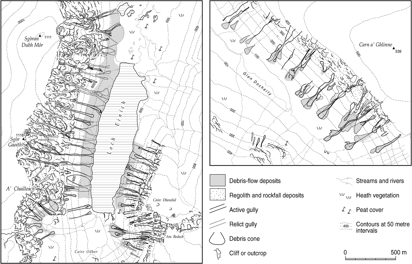
Figure 18 Debris flows and debris cones on the flanks of glacial troughs: Gleann Einich, Cairngorms (left) and Glen Docherty near Kinlochewe (right). Adapted from a map in Curry (Reference Curry1999a) and reproduced with the author's permission.
Debris flow is presently the dominant agent of sediment transport on steep drift-mantled slopes throughout the Highlands and Southern Uplands, and along the steep flanks of igneous hills in the Midland Valley (Ballantyne & Eckford Reference Ballantyne and Eckford1984; Jenkins et al. Reference Jenkins, Ashworth, Ferguson, Grieve, Rowling and Stott1988). Most recent individual flows are small and involve <100 m3 of sediment, though some have transported >1000 m3, and Milne et al. (Reference Milne, Brown, Davies and Cameron2015) have shown that both the volume of transported debris and travel distance are strongly correlated with slope length. All documented instances of recent debris-flow events in Scotland occurred during prolonged rainstorms of exceptional intensity, and the recurrence interval of flow events at sites prone to debris-flow activity is thought to be roughly 10–50 years (Ballantyne Reference Ballantyne2002c). An intense rainstorm in 1978 triggered 71 individual flows in the Lairig Ghru in the Cairngorms (Luckman Reference Luckman1992) and another in August 2004 generated 31 debris flows within Glen Ogle in Perthshire (Milne et al. Reference Milne, Werritty, Davies and Brown2009, Reference Milne, Brown and Werritty2010), two of which trapped 57 people who had to be airlifted to safety (Winter et al. Reference Winter, Heald, Parsons, Macgregor and Shackman2006).
Relict talus accumulations of Lateglacial or early Holocene age have been extensively reworked by recurrent debris flows, which have eroded deep gullies in upper talus slopes and deposited debris cones at slope foot. Gully-wall exposures through taluses on Skye and in the NW Highlands have revealed stacked debris-flow deposits intercalated with gravelly slopewash beds and/or buried organic soils of Holocene age (Salt & Ballantyne Reference Salt and Ballantyne1997; Hinchliffe et al. Reference Hinchliffe, Ballantyne and Walden1998; Hinchliffe Reference Hinchliffe and Ballantyne1999; Fig. 19), underlain at some sites by a clast-supported diamicton representing unmodified rockfall debris. The stratigraphy and dating evidence from these sites has been employed by Hinchliffe and Ballantyne (Reference Hinchliffe and Ballantyne2009) to derive a general model of talus evolution in Scotland. They proposed that an initial phase of paraglacial (Lateglacial or early Holocene) talus accumulation was succeeded by erosion and redeposition of sediment near the crest of talus slopes by translational failure, debris flow and slopewash, forming gullies that progressively extended downslope, trenching earlier slopewash and debris-flow deposits and feeding slope-foot debris cones to form the present talus landsystem (Fig. 20). This model resembles the sequence of paraglacial evolution of drift-mantled slopes following recent deglaciation (Ballantyne & Benn Reference Ballantyne and Harris1994, Reference Ballantyne, Benn, Anderson and Brooks1996; Curry Reference Curry1999b), except that in the case of relict talus slopes an initial phase of rockfall accumulation precedes the onset of net erosion.

Figure 19 Gully-wall sections through relict talus at the southern end of the Trotternish Escarpment, Isle of Skye, showing the location of dated samples and the intervening sediment units. Gradients have been reduced for clarity. Adapted from Hinchliffe (Reference Hinchliffe1999).
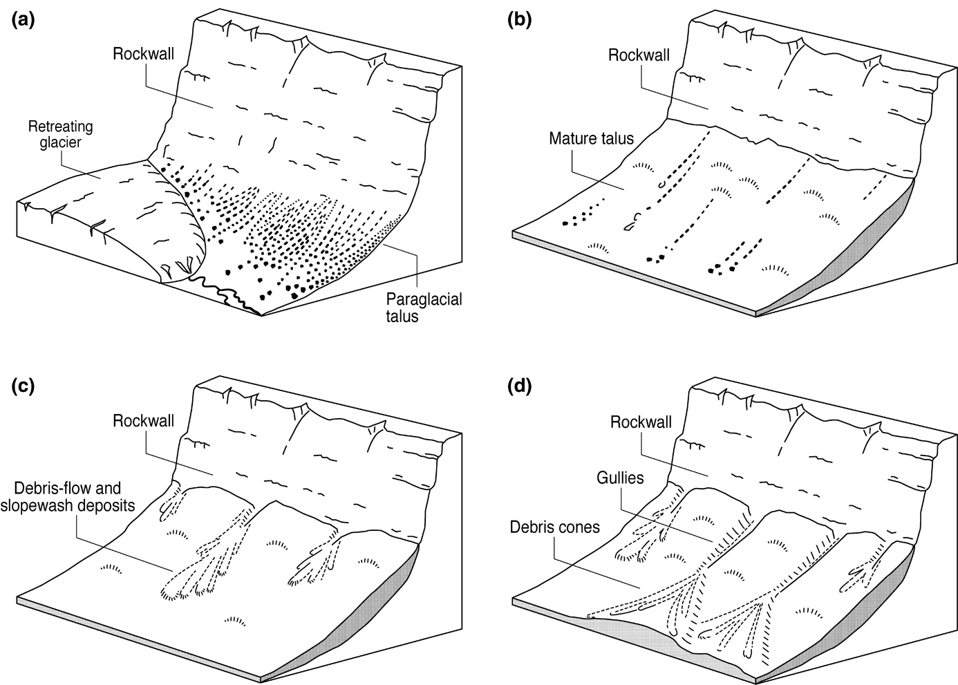
Figure 20 Model of postglacial talus evolution proposed by Hinchliffe & Ballantyne (Reference Hinchliffe and Ballantyne2009): (a) paraglacial stress release and Lateglacial frost wedging cause frequent rockfalls and rapid talus accumulation; (b) after several millennia, progressive stabilisation of the rockwall has diminished rockfall supply; soil and vegetation cover develop on the talus; (c) localised failure and gully development at the talus crest, and redeposition of sediment by debris flows and slopewash on the upper slope; (d) debris flows and runoff within gullies result in downslope gully extension and deposition of sediments as debris cones.
The timing of Holocene debris-flow activity at several sites in the Highlands has been investigated through radiocarbon dating of buried soil or peat layers underlying or intercalated with debris flow deposits. Such organic layers imply a prolonged period of stability between flow events. Radiocarbon dates obtained from the tops of organic layers provide a maximum age for the overlying debris-flow deposit, and those obtained from the base of organic layers yield a minimum age for the underlying deposit. The dating evidence from nine sites in the Highlands (Fig. 21) shows that intermittent debris-flow activity has reworked glacial drift, talus deposits and weathered bedrock over at least the last 7000 years; the absence of older organic layers is probably a sampling artefact, as most sampled exposures are <3 m deep. Although these data show that debris-flow activity has occurred throughout much of the Holocene, clustering of radiocarbon ages suggests that enhanced activity may have occurred within the last 700 years, 1700–2700 years ago and (more tentatively), 3400–3800 and 5900–6400 years ago. The long-term causes of enhanced debris flow activity are uncertain. Progressive pedogenesis may have reduced the shearing resistance of sediment-mantled hillslopes (Brooks et al. Reference Brooks, Anderson and Collinson1995) and it is possible that burning, deforestation or grazing pressure may locally have increased the susceptibility of slopes to failure and flow (Innes Reference Innes1983; Hinchliffe Reference Hinchliffe1999). Most authors have concluded, however, that exceptional rainstorm events, possibly related to longer-term climatic changes, represent the most likely explanation for debris-flow activity (Brazier & Ballantyne Reference Brazier and Ballantyne1989; Hinchliffe Reference Hinchliffe1999; Curry Reference Curry2000a, Reference Curryb; Reid & Thomas Reference Reid and Thomas2006).

Figure 21 Calibrated radiocarbon ages relating to debris-flow units overlying or underlying organic layers at nine sites on Skye and in the Scottish Highlands, showing possible periods of enhanced activity. The horizontal bars represent the 95 % confidence limits for each calibrated age. Sources: Brazier et al. (Reference Brazier, Whittington and Ballantyne1988); Brazier & Ballantyne (Reference Brazier and Ballantyne1989); Curry (Reference Curry2000a, Reference Curryb); Reid & Thomas (Reference Reid and Thomas2006); Hinchliffe & Ballantyne (Reference Hinchliffe and Ballantyne2009).
Conversely, lichenometric dating of boulders on debris-flow deposits at twelve sites in the Highlands by Innes (Reference Innes1983) initially appeared to indicate negligible activity prior to about AD 1700, and accelerated activity thereafter. This approach, however, suffers from the drawback that recent debris flows have tended to bury older debris flow deposits, introducing a sampling bias that favours younger flow ages. Luckman (Reference Luckman1992), for example, demonstrated that flows generated by the 1978 rainstorm in the Lairig Ghru largely obliterated a previous generation of debris-flow lobes deposited by a similar event in 1956. Geomorphological evidence nevertheless suggests that the past few decades or centuries may have witnessed enhanced debris-flow activity at some sites in the Highlands. If sites that have experienced recent widespread debris flow activity (such as the Lairig Ghru, Gleann Einich and Glen Docherty; Fig. 18) had experienced a similar frequency of debris-flow events throughout the Holocene, sediment cover on these slopes is likely to have been extensively depleted within a few centuries or millennia (cf. Ballantyne & Benn Reference Ballantyne and Harris1994, Reference Ballantyne, Benn, Anderson and Brooks1996; Curry Reference Curry and Morris1999b). That this is not the case suggests enhanced recent debris-flow activity at such sites, though the possible causes of such activity remain a source of debate (Innes Reference Innes1983; Brazier & Ballantyne Reference Brazier and Ballantyne1989; Ballantyne Reference Ballantyne1991).
Although debris flow represents the dominant (and morphologically most conspicuous) agent responsible for modifying sediment-mantled hillslopes, other processes have also contributed to Holocene slope evolution. Flood torrents have dissected moraines on lower slopes, locally depositing sediment as small alluvial fans (Brazier et al. Reference Brazier, Whittington and Ballantyne1988; Ballantyne & Whittington Reference Ballantyne and Whittington1999). There is also persuasive evidence, particularly for the Southern Uplands, to indicate that woodland clearance and other land-use changes during the past four millennia have made drift-mantled slopes more vulnerable to gully erosion, resulting in the deposition of small fans on valley floors (Chiverrell et al. Reference Chiverrell, Harvey and Foster2007; Foster et al. Reference Foster, Chiverrell, Harvey, Dearing and Dunsford2008; section 4.4.2) Translational landslides have also affected many drift-covered slopes, leaving cuspate scars, particularly above steep bluffs where streams have incised till deposits (Fig. 22). A related phenomenon is the occurrence of peat slides, which involve the translational sliding of intact bodies of peat over rockhead or underlying mineral soil. Such events are triggered by extreme rainstorms, usually following a period of wet weather (Acreman Reference Acreman1991; Moore et al. Reference Moore, Carey, Mills, Martin, Irinder, Kerry, Leask, Simmons and Ashaari2006; Dykes & Warburton Reference Dykes and Warburton2008; Nichol Reference Nichol2009), and a resultant increase in pore-water pressure at the base of the peat. Recorded examples have involved peat bodies up to about 3 m thick and 59,000 m3 in volume. The resultant landforms include arcuate or irregular failure scars, intact rafts of displaced peat, fragmented peat blocks and, sometimes, pressure ridges at the distal end of individual slides. Most reported examples occur on Shetland (Veyret & Coque-Delhuille, Reference Veyret and Coque-Delhuille1983; Moore et al. Reference Moore, Carey, Mills, Martin, Irinder, Kerry, Leask, Simmons and Ashaari2006; Dykes & Warburton Reference Dykes and Warburton2008), but this may reflect under-reporting of those in other upland areas.

Figure 22 (a) Cuspate scars representing former translational landslides in till deposits, Glen Artney, southern Grampians. (b) Gullies eroded in till bluffs, Carn Bhan, northern Highlands. Many such gullies were initiated as translational landslides then modified by stream erosion.
Evidence for recent snow avalanche activity in mountain areas is usually confined to uprooting of turf, localised erosion of talus and deposition of a thin spread of soil and debris downslope (Ward Reference Ward1985; Ward et al. Reference Ward, Langmuir and Beatty1985). More substantial Holocene snow avalanche landforms are limited to a small number of sites, such as an avalanche impact pit and rampart below the north face of Ben Nevis (Ballantyne Reference Ballantyne1989) and avalanche boulder tongues in the Cairngorms. The finest examples are in the Lairig Ghru, where avalanche tongues extend across the valley floor and up the opposing slope, damming the Pools of Dee at the highest point in the glen (Luckman Reference Luckman1992).
4.3. Holocene rock-slope failures
Although the great majority of RSFs in Scotland occurred during the Lateglacial (Ballantyne Reference Ballantyne2013c; Ballantyne et al. Reference Ballantyne, Sandeman, Stone and Wilson2014a), intermittent catastrophic RSFs have punctuated the Holocene. A few occurred during the final centuries of the YDS, depositing debris on LLR glaciers, notably at the foot of Maol Cheann-dearg (Torridon; dated by cosmogenic 10Be to 12.2±0.5 ka) and in Coire nan Arr (Applecross; 12.5 ± 0.6 ka). Others distributed rockslide runout debris across terrain recently vacated by LLR glacier ice, as at Carn Ghluasaid (Cluanie; 12.4±0.7 ka) and Beinn an Lochain (Arrochar; 11.5±0.6 ka). The temporal pattern of 11 dated RSFs following YDS deglaciation, however, differs from that following ice-sheet deglaciation (Fig. 9), in that these occurred throughout most of the Holocene, with no evidence for a pronounced post-deglaciation peak in RSF activity. This contrast probably reflects differences in the duration and dimensions of ice-sheet glaciation and those of glaciation during the LLR. During the former, an extensive ice sheet was present for ∼14,000 years (∼30–16 ka) and overtopped even the highest summits (Hubbard et al. Reference Hubbard, Bradwell, Golledge, Hall, Patton, Sugden, Cooper and Stoker2009; Clark et al. Reference Clark, Hughes, Greenwood, Jordan and Sejrup2012; Fabel et al. Reference Fabel, Ballantyne and Xu2012; Ballantyne & Small Reference Ballantyne and Small2018 – this volume). Conversely, most YDS glaciers in Scotland existed for less than ∼1200 years, were largely confined to glacial troughs and accomplished comparatively limited landscape modification (Golledge Reference Golledge2007, Reference Golledge2010; Golledge et al. Reference Golledge, Hubbard and Sugden2008). The apparent absence of a peak in Holocene RSF activity probably reflects relatively limited and brief loading and unloading of slopes by LLR glaciers, combined with declining rates of glacio-isostatic uplift (Fig. 10) and associated seismic activity. Notable Holocene RSFs include that from the south face of Beinn Alligin (Torridon) at ∼4.3 ka, when ∼9 Mt of bedrock failed along a 42° failure plane bounded by converging fault scarps, and coarse rock debris extended along the corrie floor for 1.25 km (Ballantyne Reference Ballantyne2003b; Ballantyne & Stone Reference Ballantyne and Stone2004); the Storr landslide (∼6.1 ka) on the Trotternish Escarpment, Skye, which produced the 49 m high pinnacle of the Old Man of Storr (Ballantyne Reference Ballantyne and Cooper2007a); and the rock avalanche near the mouth of Coire Gabhail (the Lost Valley) near Glen Coe, where ∼0.6 Mt of rhyolitic ignimbrite failed about 1700 years ago, damming the upper glen (Ballantyne Reference Ballantyne and Cooper2007b). The absence of any trend in the timing of dated catastrophic Holocene RSFs in the Highlands suggests that the probability of such failures has changed little over the past ∼10 ka (Ballantyne & Stone Reference Ballantyne and Stone2013).
4.4. Holocene fluvial environments
There has been considerable debate as to whether the pattern and timing of Holocene alluvial aggradation and incision reflects (1) long-term climatic fluctuations; (2) exceptional flood events, possibly related to such wetter or cooler periods; (3) natural changes in the vegetation and peat cover of catchments; (4) anthropogenic influences, due particularly to the effects of woodland clearance, burning and grazing pressure in altering runoff regime and lowering the threshold for hillslope erosion of hillslopes; or (5) autogenic changes in alluvial reaches, locally related to changes in base level. This issue has been addressed both for individual catchments, as outlined below, and through compilation of UK-wide datasets based on radiocarbon dating of organic material buried, overlying or contained within alluvial sediments. Based on such evidence Macklin et al. (Reference Macklin, Jones and Lewin2010, Reference Macklin, Lewin and Jones2013) identified 17 multi-centennial periods of flooding and river instability during the Holocene and six periods of accelerated incision for the UK as a whole; subdivision of their dataset also allowed periods of ‘instability' and ‘stability' to be identified for particular regions. From the available data from nine sites in the NW Highlands and W Grampians, for example, they identified ‘instability' in fluvial systems at 3.8–3.3 ka, 2.3–1.7 ka, 1.4–1.1 ka and 0.7–0.5 ka.
The validity of this approach for Scotland is questionable. It lumps together not only radiocarbon ages from major floodplains and from small alluvial fans, which may have responded to entirely different controls, but also incorporates ages for manifestly non-alluvial settings, such as buried soils within the upper parts of talus slopes (e.g., Hinchliffe Reference Hinchliffe1999) and inwash of soil into peat-filled upland basins (e.g., Tipping Reference Tipping1995a). Such cavalier misappropriation of radiocarbon ages from non-alluvial settings compromises the integrity of the datasets and undermines the confidence that can be placed in such meta-analyses.
Even after exclusion of inappropriate sites, the limited dating evidence for the behaviour of Scottish river systems is incompatible with such an approach, for two main reasons. First, changes in river behaviour during the late Holocene took place against a backdrop of spatially-diachronous anthropogenic influence, particularly through woodland clearance, burning, grazing pressure and expansion of agriculture. Secondly, because major rivers generally occupy broad valleys, there is usually an imperfect coupling between hillslopes and steep tributary valleys with main channels: sediment has often been deposited as alluvial fans and debris cones along the flanks of major valleys rather than entering trunk rivers. In consequence, there is a marked asynchronicity between periods of floodplain aggradation and episodes of fan accumulation (e.g., Tipping & Halliday Reference Tipping, Carter and Haggart1994; Ballantyne & Whittington Reference Ballantyne and Whittington1999; Reid et al. Reference Reid, Thomas, Tipping and Tipping2003; Foulds & Macklin Reference Foulds and Macklin2006). There is also evidence that periods of floodplain aggradation or incision may even be asynchronous within a single catchment (e.g., Tipping Reference Tipping and Tipping1999; Tipping et al. Reference Tipping, Milburn, Halliday, Brown and Quine1999), and that the Holocene history of lowland rivers differs from that of upland rivers (Tipping et al. Reference Tipping, Jones, Carter, Holden and Cressey2008).
4.4.1. Holocene floodplains and terraces
The available evidence suggests that there may be systematic contrasts in floodplain and terrace evolution in the Highlands, the Southern Uplands and the Midland Valley; these regions are considered in turn below.
4.4.1.1. The Scottish Highlands
Low-level terraces (usually <3–4 m above the active floodplain) are widespread in alluvial reaches of the main Highland glens (Robertson-Rintoul Reference Robertson-Rintoul1986; Rumsby et al. Reference Rumsby, McVey, Brasington, Maddy, Macklin and Woodward2001; Ballantyne Reference Ballantyne2008). Dating evidence exists for only three sites, all of which indicate floodplain aggradation then incision during the late Holocene. In Glen Licht (Kintail) the base of an extensive peat layer overlying a low alluvial terrace has yielded three similar radiocarbon ages averaging ∼4.5 cal 14C ka (Reid et al. Reference Reid, Thomas, Tipping and Tipping2003); assuming that peat growth commenced shortly after floodplain abandonment, this date marks the approximate culmination of floodplain aggradation and is maximal for subsequent incision. In upper Glen Feshie, a single radiocarbon age of 4.1–3.9 cal 14C ka was obtained by Robertson-Rintoul (Reference Robertson-Rintoul1986) for charcoal fragments in an organic layer buried by alluvial gravels that form a low terrace, and hence constrains subsequent aggradation then incision. In the Edendon valley near Drumochter, Ballantyne & Whittington (Reference Ballantyne and Whittington1999) showed that Holocene floodplain aggradation peaked between ∼2.7 cal 14C ka and ∼2.4 cal 14C ka about 2 m above the active channel. The widespread occurrence of a prominent low terrace flanking alluvial reaches of major valleys in the Highlands (particularly the Eastern Grampians) led Ballantyne (Reference Ballantyne2008) to conjecture that late Holocene aggradation then incision may have been widespread in the Highlands, producing what he termed the Main Holocene Terrace, but this requires testing through targeted dating of organic material below and overlying the terrace surface. All higher terraces in the Highlands appear to be of Lateglacial age (section 3.4.1), suggesting that floodplain stability or net incision characterised much of the earlier Holocene. The pattern of floodplain aggradation and incision for rivers terminating at the coast, however, has been distinctly different, being related to rise and fall of relative sea level, so that prominent terraces merge downstream with raised beaches (Tipping et al. Reference Tipping and Halliday1994).
4.4.1.2. The Southern Uplands and Cheviot Hills
Much of current understanding of floodplain changes and terrace development in the Southern Uplands and Cheviots stems from studies by Richard Tipping and his co-researchers, who combined field survey, logging of exposures, sediment analysis and radiocarbon dating of buried organic material with analyses of pollen spectra and archaeological evidence in attempts to link river behaviour to climate change and/or anthropogenic influences. For rivers draining the Cheviots, Tipping's research suggests diverse sequences of floodplain evolution. The top of a peat layer underlying extensive terrace gravels at Wooler Water produced an age of 4.2–4.0 cal 14C ka, and roots at the base of terrace gravels flanking a tributary of Bowmont Water yielded an age of 4.6–4.3 cal 14C ka. Tipping (Reference Tipping, Needham and Macklin1992) considered these ages ‘broadly synchronous' with palynological evidence for Neolithic woodland clearance (∼4.7–4.2 cal 14C ka), and inferred that subsequent floodplain aggradation may reflect deforestation and increased sediment supply. In the upper Bowmont Valley, the highest terrace is undated, but the abandonment of a second terrace appears to have occurred within the past 350–220 years, leading Tipping (Reference Tipping1994) to suggest that subsequent floodplain incision may have been due to increased flood activity during the Little Ice Age. At Akeld Steads, on the floodplain of the River Glen, radiocarbon ages for peat samples recovered from cores indicate trenching during the YDS, succeeded by peat accumulation interrupted by episodes of overbank sedimentation throughout the Holocene until ∼4.0–3.5 cal 14C ka, with no evidence of intervening or subsequent incision (Tipping Reference Tipping1998). These contrasts in alluvial history illustrate the difficulty of attributing fluvial response to a general sequence of events related to climate changes or anthropogenic impacts.
Complications in the interpretation of Holocene alluvial sequences are also illustrated by research on the floodplain sequence in upper Annandale, where cores have revealed intercalated sequences of peat and overbank deposition (Tipping Reference Tipping and Tipping1999; Tipping et al. Reference Tipping, Milburn, Halliday, Brown and Quine1999). An upstream transect records overbank sedimentation between ∼4.8 cal 14C ka and ∼3.9 cal 14C ka, but this sequence is absent in cores retrieved farther downvalley. Renewed sedimentation, coeval with Iron Age settlement expansion, is recorded between ∼3.0 cal 14C ka and ∼2.1 cal 14C ka, but is diachronous across the floodplain. A major aggradational event at ∼1.9–1.5 ka cal 14C ka was attributed by Tipping et al. (Reference Tipping, Milburn, Halliday, Brown and Quine1999) to anthropogenic impacts, and a final period of extensive sedimentation occurred at ∼0.6 ka. However, the sediment sequence for a tributary valley records only sedimentation events at ∼1.4 ka and ∼0.7 ka. Tipping et al. (Reference Tipping, Milburn, Halliday, Brown and Quine1999) interpreted the alluvial-peat sequence in upper Annandale as a series of sedimentation episodes separated by periods of relative quiescence, but they also emphasised the asynchronicity of events recorded within the basin. Their findings suggest that the history of Holocene alluviation may differ within a single catchment or across a single floodplain, and hence may not be fully captured by the stratigraphy of individual sites.
Similar complexity is highlighted in a study by Tipping (Reference Tipping1995b) of terraces flanking the Kirtle Water, which drains a 110 km2 catchment that terminates at the Solway Firth. The uppermost of five terraces (T1) is probably of Lateglacial age, and T2 (KB II and PG II in Figure 23) appears to represent floodplain aggradation after ∼10.4 cal 14C ka and incision after ∼5.4 14C ka. T3 is undated. Tree growth dated to ∼2.6 cal 14C ka in one reach and peat accumulation in another between ∼2.2 cal 14C ka and ∼1.5 cal 14C ka was succeeded by diachronous floodplain aggradation to the level of T4 (KB IV and PG IV), followed by incision after ∼0.7 cal 14C ka; from historical evidence the lowest terrace (T5) appears to represent the floodplain in AD ∼1750. Tipping struggled to assign causality to these changes: he attributed the cycle of aggradation and incision represented by T2 to early Holocene “climatic oscillations” and the diachronous aggradation represented by T4 to “a spatially discrete anthropogenic cause”. It is possible that the latter reflects reduced slope stability following major woodland clearance at ∼2.0 cal 14C ka.
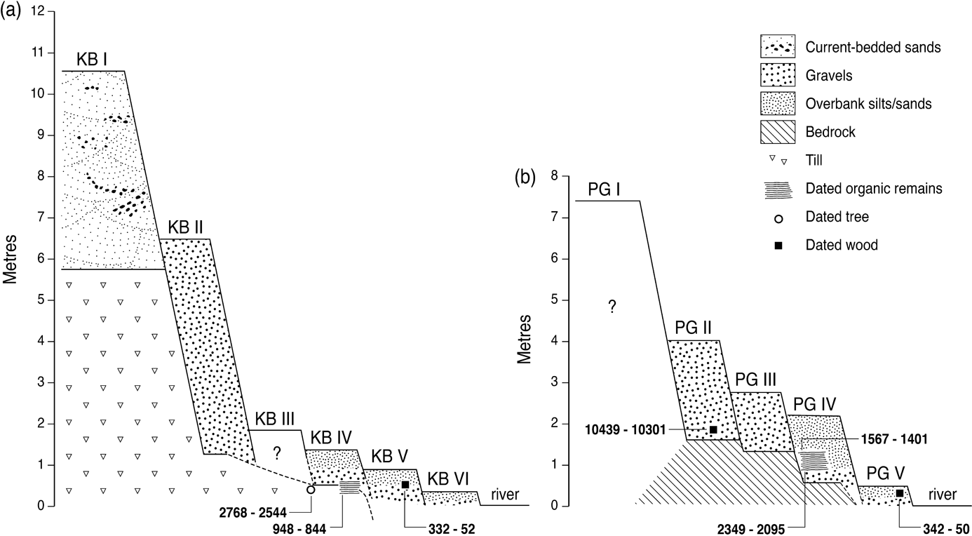
Figure 23 Schematic illustration of river terraces in the Kirtle Water catchment and associated radiocarbon ages of dated organic material: (a) terraces KB I to KB VI of the Kirk Burn near its confluence with Kirtle Water; (b) terraces PG I to PG V of the middle reach of Kirtle Water near Palmersgill Bridge. The figures represent calibrated ±1σ age ranges (cal 14C a) of radiocarbon dates, referenced to AD 2000. Adapted from Tipping (Reference Tipping1995b).
The evidence from these sites in southern Scotland suggests that floodplain stability or aggradation was typical of much of the early to mid-Holocene, but that subsequent alluvial history was catchment- or even reach-specific. The evidence relating late Holocene alluviation or incision to prehistoric land-use change (particularly woodland clearance) through coincidence of timing is suggestive but remains tantalizingly inconclusive.
4.4.1.3. The Southern Uplands and Cheviot Hills
A study by Tipping et al. (Reference Tipping, Jones, Carter, Holden and Cressey2008) of the alluvial deposits of the River Kelvin between Kirkintilloch and Kilsyth suggests that the Holocene alluvial history of the comparatively low-energy river systems of the Midland Valley (Central Lowlands) differs markedly from that of their upland counterparts. Multiple cores retrieved from four transects across the River Kelvin floodplain revealed up to ∼3.5 m of mainly fine-grained sediments, locally underlain by peat up to ∼1.5 m thick. Four radiocarbon dates from the top of the peat range from 8.8–8.6 cal 14C ka to 6.7–6.6 cal 14C ka implying subsequent net floodplain aggradation, and eight dates from the base of the peat range from 11.7–11.4 cal 14C ka to 5.8–5.7 cal 14C ka implying floodplain aggradation during the early Holocene. A Roman fortification, the Antonine Wall, cuts across the present flood plain, implying that aggradation must have ceased by the time of its construction in AD 140. Tipping et al. (Reference Tipping, Jones, Carter, Holden and Cressey2008) concluded that the uppermost 4–6 m of alluvial deposits accumulated during the early and middle Holocene, and that floodplain aggradation ceased at least 2000 years ago, and probably much earlier.
4.4.2. Holocene alluvial fans
Holocene alluvial fans are common in major valleys in upland Scotland. Some are low-gradient ‘confluence' fans that are inset within Lateglacial fans at the mouths of major tributaries, as at the Feshie–Spey confluence (Werritty & McEwen Reference Werritty, McEwen and Gregory1997). The majority, however, are small fans, often located on Holocene floodplain terraces, at the mouths of steep tributary valleys or gully systems. Such fans represent episodic erosion of drift-mantled slopes by a combination of flood torrents and, in some cases, channelised debris flows.
For small valley-side fans the timing of episodes of fan accumulation therefore represents that of destabilisation of slopes in the fan catchment, and can be determined by radiocarbon dating of organic material buried under or interbedded with fan deposits. Most small fans appear to have accumulated as a result of a small number of exceptional flood events. This has been demonstrated for a fan in the Edendon valley (Fig. 24), where dating of the top and base of peat horizons that extend across the full width of the fan has shown that the fan accumulated on the underlying late Holocene terrace in just three depositional events at ∼2.2 cal 14C ka, ∼2.0 cal 14C ka and ∼0.8 cal 14C ka (Ballantyne & Whittington Reference Ballantyne and Whittington1999). During these events, sediment was stripped from the walls of the parent gully, ultimately building a fan with a volume of ∼6750 m3 that accumulated in just a few hours within an overall timescale of more than two millennia. Similarly, a larger (∼125,000 m2) fan that accumulated over peat after ∼3.8 cal 14C ka and continued to prograde until after ∼1.2 cal 14C ka over a Holocene terrace in Gleann Licht (Kintail) was interpreted by Reid et al. (Reference Reid, Thomas, Tipping and Tipping2003) as representing 12–15 discrete sedimentation episodes. A recent analogue for such episodic fan accumulation is provided by an exceptional flood event that resulted in the deposition of a layer of coarse sediment on small fans in the Howgill Fells in NW England (Harvey Reference Harvey1986; Wells & Harvey Reference Wells and Harvey1987).

Figure 24 Exposure on a small Holocene alluvial fan, the Edendon Fan [NN 715776]. Three peat layers (dark layers on the photograph) extend across the entire width of the fan. Radiocarbon dating of samples from the top and base of each peat layer has demonstrated that each intervening sediment bed represents a single depositional event. The lowest peat layer has developed on a terraced floodplain that ceased to aggrade between ∼2.7 cal 14C ka and ∼2.4 cal 14C ka.
Radiocarbon dates constraining the timing of valley-side fan deposition reveal a remarkable temporal focus. With a single questionable exception – a small fan or debris cone in Gleann Licht that probably represents episodic debris-flow deposition after ∼7.5 cal 14C ka (Reid et al. Reference Reid, Thomas, Tipping and Tipping2003) – all dated fans appear to have been deposited after ∼4.0 ka (Fig. 25). Moreover, there is no evidence that this temporal pattern reflects erosion of evidence for earlier Holocene fans, as earlier fan remnants are either absent or of demonstrably of Lateglacial age. This pattern is not confined to Scotland, as all of 37 radiocarbon ages obtained for alluvial fans in NW England also indicate fan accumulation (and thus gully erosion) after ∼4.0 ka (Foster et al. Reference Foster, Chiverrell, Harvey, Dearing and Dunsford2008).
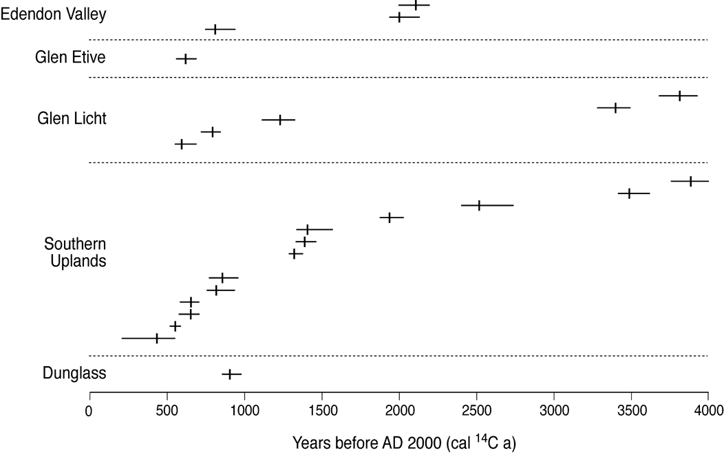
Figure 25 Calibrated radiocarbon ages relating to individual sediment deposition episodes on Holocene alluvial fans. Horizontal bars represent the ±2 σ range and vertical dashes represent the median age. Dates from Glen Etive (Brazier et al. Reference Brazier, Whittington and Ballantyne1988), Dunglass (Tipping Reference Tipping2007) and most for the Southern Uplands (Foster et al. Reference Foster, Chiverrell, Harvey, Dearing and Dunsford2008) represent the onset of fan accumulation. Those for Edendon (Ballantyne & Whittington Reference Ballantyne and Whittington1999) and Gleann Licht (Reid et al. Reference Reid, Thomas, Tipping and Tipping2003) represent the onset of accumulation (oldest age) and timing of later sedimentation events.
In addressing this phenomenon, Chiverrell et al. (Reference Chiverrell, Harvey and Foster2007) and Foster et al. (Reference Foster, Chiverrell, Harvey, Dearing and Dunsford2008) have demonstrated that there is no link between the timing of enhanced gully erosion and periods of cooler or wetter climate identified from peat humification data, particularly as cooler or wetter shifts prior to ∼4.0 ka do not appear to have produced gully erosion and concomitant fan formation. Amassing a wealth of historical, archaeological and palynological data, they argued that phases of enhanced gully erosion followed cycles of settlement expansion and land use change in upland areas. Woodland clearance, burning and grazing pressure probably represent the most important factors preconditioning drift-mantled slopes to erosion; they envisaged that such clearance lowered the threshold of stability of such slopes, rendering them more vulnerable to gully formation, incision and expansion during and probably after exceptional rainstorm events. For the Southern Uplands, they suggested that sporadic gullying events occurred during the Late Bronze to Iron Age (∼4.0–2.0 ka), but that the most intensive periods of gullying occurred at ∼1.3–1.1 ka (AD 700–900), 0.9–0.7 ka (AD 1100–1300) and after 0.55–0.45 ka (AD 1450–1550), with little evidence of activity over the past ∼150 years. This analysis is based on a limited number of radiocarbon ages from sites in the Southern Uplands (Fig. 25) but is strongly supported by the dating evidence for fans in NW England, and indeed is consistent with the timing of depositional episodes on three Highland fans (Edendon valley, Glen Etive and Gleann Licht) and that of valley-fill deposition at Dunglass in SE Scotland (Tipping Reference Tipping2007).
The arguments and data presented by Chiverrell et al. (Reference Chiverrell, Harvey and Foster2007) and Foster et al. (Reference Foster, Chiverrell, Harvey, Dearing and Dunsford2008) are compelling, but evidence from individual sites suggests a more complex picture. In Glen Etive, there is palynological evidence of clearance for agriculture prior to fan formation (Brazier et al. Reference Brazier, Whittington and Ballantyne1988), but elsewhere such evidence is lacking. For the Hopecarton Burn fan, which rests on a terrace of the River Tweed, Tipping & Halliday (Reference Tipping, Carter and Haggart1994) adduced from pollen evidence that no woodland clearance occurred in the fan catchment prior to fan deposition at ∼0.9 ka, and there is a similar lack of palynological evidence for any form of anthropogenic landscape change prior any of the three storm runoff events that formed the Edendon fan between ∼2.2 ka and ∼0.8 ka (Ballantyne & Whittington Reference Ballantyne and Whittington1999). It is possible that pedogenesis throughout the Holocene may have progressively reduced the stability of drift-mantled slopes, as argued by Brooks et al. (Reference Brooks, Anderson and Collinson1995), and it seems likely that early Holocene paraglacial fans accumulated in the Highlands (Brazier Reference Brazier1987) but are not associated with burial of organic material suitable for radiocarbon dating. The work of Chiverrell et al. (Reference Chiverrell, Harvey and Foster2007) and Foster et al. (Reference Foster, Chiverrell, Harvey, Dearing and Dunsford2008) has provided valuable insights into the history of Holocene alluvial fans in Scotland and NW England, but a fuller picture may yet emerge.
4.4.3. Bedrock channels
An interesting recent development has been research on the postglacial evolution of bedrock channels in Scottish rivers. Particular attention has been focused on knickpoint retreat initiated by glacio-isostatic uplift and consequent fall of relative sea level, which lowered the base level for tidewater-terminating rivers. For 14 such rivers in E Scotland, Bishop et al. (Reference Bishop, Hoey, Jansen and Lexartza Artza2005) showed that the retreat distance of knickpoints initiated by sea-level fall from the postglacial marine limit ranges from 76 m for the smallest catchment to 21.5 km for the largest. They found that the distance of knickpoint retreat exhibits a strong positive correlation with catchment area, implying that retreat rate has been essentially determined by stream discharge. A similar conclusion was reached by Castillo et al. (Reference Castillo, Bishop and Jansen2013) from a study of knickpoint retreat from the marine limit on the Isle of Jura. This study showed that the power law relationship between knickpoint retreat distance and catchment area for streams flowing westward across scarp slopes is almost identical to that for those flowing eastward across dip slopes, implying that the rate of knickpoint recession has been insensitive to underlying structural trends on (quartzite) rocks of uniform resistance.
Changes in the rate of postglacial knickpoint retreat have been reconstructed by Jansen et al. (Reference Jansen, Fabel, Bishop, Xu, Schnabel and Codilean2011) through cosmogenic 10Be exposure dating of strath terraces (bedrock channel remnants elevated above the present stream channel) for four rivers draining into Loch Linnhe. They found that downcutting of bedrock channels due to a lowering of base level (relative sea level) has occurred through both knickpoint retreat and diffusive transport-limited river incision. Strath exposure ages show that channel incision commenced at ∼11.5 ka, shortly after retreat of LLR glaciers, and that knickpoints subsequently retreated up-channel through bedrock detachment. The exposure ages also demonstrate that the rate of knickpoint retreat in all four catchments was greatest in the early to mid-Holocene and has since declined, approximately exponentially, by two orders of magnitude. This radical decline in knickpoint retreat rate they attributed to progressive diminution of paraglacial sediment supply to these rivers, as coarse sediment forms the ‘tools' by which rivers both detach bedrock at knickpoints and incise bedrock channels.
Other studies have focused on controls on postglacial channel morphology. For bedrock rivers draining the W Grampians, Jansen et al. (Reference Jansen, Codilean, Bishop and Hoey2010) found that channels underlain by the most resistant lithology (quartzite) are associated with channel steepening by a factor of 1.5–6.0, with typically only slight channel narrowing, and that bedrock channel width tends to increase nonlinearly with catchment area. They suggested that knickpoints on quartzite outcrops may be inherited from steps in glacial troughs produced by differential glacial erosion, and that such outcrops form pinning points that have slowed knickpoint recession. The role of differential glacial erosion in conditioning the long profiles of rivers in the Highlands has also been emphasised by Whitbread et al. (Reference Whitbread, Jansen, Bishop and Attal2015), who studied the effects of substrate, sediment and slope controls on the channel geometry of both bedrock and alluvial reaches of three rivers in NW Scotland. Their measurements also showed that reach-averaged channel width (and to a lesser extent channel depth) scale with upstream catchment area and thus discharge. Their data also indicate that bank and bed materials have exercised secondary (mainly localised) controls on channel morphology, and that channel slope strongly governs the transition between bedrock and alluvial reaches, due to its influence on sediment transport and bed cover. A study of channel reach morphology in upland tributaries of the Dee above Aboyne (Addy et al. Reference Addy, Soulsby, Hartley and Tetzlaff2011) has confirmed that channel geometry and morphology are adjusted to discharge, slope and the calibre of bed material. Their study also showed that many reaches do not fit readily into the bedrock, cascade, step-pool, plane-bed and pool-riffle continuum established for other environments, but that transitional, mixed alluvial-bedrock and wandering channel reaches are common. From the strong scaling of bedrock channel widths with upstream catchment area, Whitbread et al. (Reference Whitbread, Jansen, Bishop and Attal2015) inferred that postglacial fluvial erosion has been sufficient to reconfigure bedrock channel morphology in the 12–15 ka since deglaciation, implying that although ancestral bedrock channels were probably cut by glacial meltwater streams, postglacial fluvial erosion has resulted in the progressive adaptation of channels to Holocene discharge and sediment supply regimes.
4.4.4. Recent behaviour of fluvial systems
Research on the recent behaviour of fluvial systems has adopted three overlapping approaches: (1) studies of the geomorphological impact of extreme flood events; (2) use of maps and aerial photographs to reconstruct historical channel planform changes (Fig. 26); and (3) field investigation of short-term channel changes and sediment transport. McEwen (Reference McEwen and Gordon1997) and Werritty & McEwen (Reference Werritty, McEwen and Gregory1997) have summarised earlier work on these topics. Werritty & Hoey (Reference Werritty and Hoey2003) have classified Scottish rivers into eleven types (Table 1) that form a useful basis for discussion. Large catchments such as those of the Spey, the Dee and the Tweed contain most of the categories identified in Table 1, with headwater streams and mountain torrents feeding meandering, locally braided and wandering gravel-bed rivers on floodplains where channels are often locally constrained either naturally, by bedrock or Lateglacial terraces, or artificially by flood embankments, bank reinforcement or resectioning.

Figure 26 (a) Channel planform change of the River Tummel above its confluence with the Tay, characteristic of the behaviour of a wandering gravel-bed river. Adapted from Winterbottom (Reference Winterbottom2000). (b) Channel change of the River Clyde at its confluence with the River Medwin, showing downstream migration of meanders; 400 m above the confluence, the neck of a meander was cut through between 1858 and 1909. Adapted from Brazier et al. (Reference Brazier, Kirkbride and Werritty1993).
Table 1 Typology of Scottish fluvial environments

Classification based on Werritty & Hoey (Reference Werritty and Hoey2003). Large catchments such as those of the Spey, Findhorn, Dee and Tweed include most of the above categories
Perhaps inevitably, most research has focused on sites that exhibit the greatest recent activity, particularly categories 1–4 in Table 1. Many of these are located on what Werritty & Leys (Reference Werritty and Leys2001) termed ‘piedmont zones': high-energy, low threshold fluvial environments located where steep mountain streams join the floodplains of major rivers. In such areas, exceptional flood events play a major role in redistributing coarse sediment and remodelling channel planform. The effects of the largest recorded historic flood in the UK, the ‘Muckle Spate' of 1829 in the Moray region of NE Scotland, were documented in detail by Lauder (Reference Lauder1830). From his account and field evidence, McEwen & Werritty (Reference McEwen and Werritty2007) retrodicted an approximate peak discharge (up to ∼1500 m3 s–1 on the main stem of the River Findhorn) and its effects within the Findhorn catchment. Within bedrock or mixed bedrock-alluvial reaches, the flood appears to have had limited impact, but within unconfined alluvial reaches, particularly near the mouth of the river, it caused widespread bank erosion, excavated new channels and deposited sheets of sand and gravel over adjacent low ground, leading to destruction of property, despoliation of agricultural land and destitution of the local populace. The flashy response to convectional rainstorms of rivers draining steep upland catchments also has a marked (if localised) impact, causing bank erosion, channel scour and redistribution of sediment over downstream fans and low terraces (Acreman Reference Acreman1983, Reference Acreman1991). The best-documented case of the geomorphic impacts of flash flooding in a mountain torrent is that for the Allt Mór, which drains a steep catchment in the NW Cairngorms (McEwen & Werritty Reference McEwen and Werritty1988). Though the upper, boulder-floored reaches of the Allt Mór experienced limited modification, entrenched reaches underwent extensive erosion and the alluvial fan at its downstream confluence experienced channel avulsion and development of two new channels, one of which now carries most of the flow. Similar flood impacts have been recorded on piedmont zone rivers: on the Dorback Burn, a tributary of the River Nethy, repeated surveys showed that extreme rainstorm events had completely remodelled the active channel (Werritty Reference Werritty, Burt and Walling1984), whilst detailed research on a braided reach of the River Feshie revealed that major flood events have tended to obliterate the former channel pattern and replace it with a chaotic braided system with numerous unstable bars and channels (Werritty & Ferguson Reference Werritty, Ferguson, Cullingford, Davidson and Lewin1980). Studies of channel change on the River Feshie using sequential aerial photographs and high-resolution digital elevation models have confirmed that channels within alluvial reaches are intrinsically unstable, with evidence of flow reorganisation, channel avulsion, lateral channel switching, erosion of sediment from bars and channels and the deposition of sediment in channels operating over annual to decadal timescales (Rumsby et al. Reference Rumsby, McVey, Brasington, Maddy, Macklin and Woodward2001, Reference Rumsby, Brasington, Langham, McLelland, Middleton and Rollinson2008). Modification of channel patterns during floods is probably less pronounced in lowland rivers, but these are not exempt: a flood with an estimated 70-year return period on the lower Tay in 1990 eroded two new channels along the routes of palaeochannels (Gilvear & Harrison Reference Gilvear and Harrison1991).
As the above examples illustrate, major flood events trigger bed mobility, sediment redistribution, avulsion, bar migration and bank erosion, particularly on unconfined reaches of braided and wandering gravel-bed rivers. There is evidence, though, that post-flood floodplains are metastable, being subject to more gradual modification by lower flows. On the River Feshie, there is evidence of a progressive replacement of post-flood braidplains by sinuous single-thread channels that locally divide around medial bars (Werritty & Ferguson Reference Werritty, Ferguson, Cullingford, Davidson and Lewin1980), leading Ferguson & Werritty (Reference Ferguson and Werritty1983) to propose that the Feshie and kindred wandering gravel-bed rivers are subject to divergent meandering and braiding tendencies that do not permit evolution towards a steady stable channel configuration. This appears to be supported by studies of channel pattern changes on the River Feshie (Rumsby et al. Reference Rumsby, McVey, Brasington, Maddy, Macklin and Woodward2001) and the River Dee, where an increased frequency of moderate flood events has been associated with an increased propensity for channel subdivision (McEwen Reference McEwen, Beven and Carling1989). Channel gradient plays a key role in determining the dominance of braiding or meandering channels. Studies on the lower Allt Dubhaig (Drumochter), have demonstrated that a progressive reduction in channel gradient is accompanied by gradual replacement of a near-braided planform by a meandering channel then, on the lowest gradients, by a stable sinuous channel (Ferguson & Ashworth Reference Ferguson and Ashworth1991). Repeated downstream sequences of channel reach type are common in Highland glens and upland tributaries, where individual alluvial reaches are graded to local base levels represented by bedrock steps that reflect differential glacial erosion of valley floors (Whitbread et al. Reference Whitbread, Jansen, Bishop and Attal2015), though the nature of such sequences is locally influenced by topographic controls (channel confinement) and coarse bed materials derived from glacigenic deposits (Addy et al. Reference Addy, Soulsby and Hartley2014).
The question of stability of piedmont rivers in upland Scotland has been addressed by Werritty & Leys (Reference Werritty and Leys2001) through the reconstruction of the channel planforms of nine rivers based on maps and aerial photographs covering the period since the mid-18th Century. Although all these rivers exhibited changes in planform in response to major floods and inter-flood adjustment (manifest in lateral channel shift, and changes in active channel area and channel sinuosity), none exhibited a systematic change in state, apart from one affected by an artificial rise in base level. The implication is that over the past 200-250 years, there has been an approximate balance between formative discharge regime, channel gradient and sediment supply; such rivers are reworking floodplain surfaces, but have exhibited no intrinsic tendency for net floodplain aggradation or incision.
Similar historical evidence has been used to illustrate the nature of channel pattern changes in a range of fluvial environments. For the lower Spey, a steepening of the valley floor by glacio-isostatic uplift has resulted in the extensive development of braided channels. Lewin & Weir (Reference Lewin and Weir1977) calculated that the lower Spey had reworked about 50 % of its floodplain since 1880, and mapping by Riddell & Fuller (Reference Riddell and Fuller1995) shows that near the coast, the main channel of the Spey shifted laterally by up to 400 m between 1968 and 1992. Avulsion of the main channel of the River Coe above Loch Achtriochan has caused it to shift laterally by over 200 m between 1962 and 1988 (McEwen Reference McEwen1994; Fig. 27). Studies of channel planform change of the River Tay since 1783 have shown that some reaches experienced little change over 200 years, though steeper reaches experienced lateral channel migration of up a kilometre (Gilvear & Winterbottom Reference Gilvear and Winterbottom1992). Both the Tay and its tributary, the Tummel (Fig. 26a), have shown a tendency to channel narrowing since the mid-18th Century, a trend attributed by Winterbottom (Reference Winterbottom2000) to flood embankment construction after the mid-19th Century and subsequent flow regulation. Over a similar timescale, meandering rivers flowing over low-gradient floodplains in lowland areas have exhibited a tendency for downstream meander migration, accompanied by increasing sinuosity until cut-through of meander necks during floods isolates ox-bow lakes in abandoned channels (Brazier et al. Reference Brazier, Kirkbride and Werritty1993; Fig. 26b). Increased regulation of lowland rivers, however, means that most lowland meandering streams are now ‘inactive' (category 6 in Table 1), so that recent channel changes have been limited.

Figure 27 The River Coe above Loch Achtriochan, a typical wandering gravel-bed river, photographed in June 2005. The palaeochannel nearest the road was active before 1875. The main channel switched to the far side of the floodplain before 1887 and remained there until after 1962, before switching to its 2005 position sometime before 1988 (McEwen Reference McEwen1994).
5. Discussion
Although the distinctive signature of recurrent Pleistocene glaciations remains the dominant feature in much of the Scottish landscape, a wide range of postglacial geomorphological processes has resulted in extensive modification of the glacial landscape. Appreciation of the nature and effects of postglacial processes is a comparatively recent development. Whereas a vast literature on the glacial landforms and deposits of Scotland has accumulated over nearly two centuries, almost all research on postglacial landscape evolution outside the coastal zone belongs to the past three decades, and has engaged a comparatively small number of researchers. One consequence is that there are still major gaps in our understanding of this topic; another is that this remains a fertile area for future research. Some research priorities are briefly outlined below.
5.1. Lateglacial periglaciation
As outlined above (see section 3.1), much of our current understanding of Lateglacial periglaciation and permafrost development on low ground dates back to research carried out over 50 years ago, when understanding of modern analogues was limited. We now have a much greater understanding of the structural, sedimentological and micromorphological characteristics of relict periglacial phenomena such as ice-wedge pseudomorphs, relict sand wedges, involutions, fragipans and formerly permafrozen soils, and the palaeoenvironmental significance of such features (Ballantyne Reference Ballantyne2017). Moreover, Lateglacial periglacial features that occur elsewhere in the British Isles and NW Europe, such as loess and coversand deposits, thermokarst features, ground-ice depressions and active-layer detachment failures (e.g., Ballantyne & Harris Reference Ballantyne and Benn1994; Isarin Reference Isarin1997; Kasse et al. Reference Kasse, Vandenberghe, De Corte and Van Den Haute2007; Andrieux et al. Reference Andrieux, Bertran and Saito2016; Murton & Ballantyne Reference Murton and Ballantyne2017), have hitherto not been recorded in Scotland. The lack of recent research on lowland periglacial phenomena in Scotland suggests that such deposits and landforms may simply not have been recognised. Given the abundance of exposures in superficial deposits (particularly gravel pits), the availability of satellite and airphoto imagery for the detection of features such as polygonal crop marks and ground-ice depressions, improved techniques of soil micromorphological analyses and the availability of sediment dating techniques (principally OSL dating), there is potential for unravelling a more detailed history of Lateglacial periglaciation and permafrost than that summarised in section 3.1. The most urgent question relates to the status of past permafrost during the YDS. Strategies for addressing this question include searching for permafrost indicators (relict frost wedges, thermal contraction crack polygons and ground-ice depressions) in YDS outwash deposits, and stratigraphic analyses of Lateglacial deposits to elucidate the history of permafrost aggradation and degradation.
5.2. Slope failures and debris flows
5.2.1. Rock-slope failures
Although TCN dating of catastrophic RSFs has advanced our understanding of their timing and causes (Ballantyne et al. Reference Ballantyne, Sandeman, Stone and Wilson2014a), many of the largest RSFs in both the Highlands and the Southern Uplands are deep-seated gravitational slope deformations (Jarman Reference Jarman2006) of unknown age and uncertain cause. TCN dating of the failure planes or antiscarps associated with rock-slope deformations (Hippolyte et al. Reference Hippolyte, Bourlès, Léanni, Braucher, Chauvet and Lebatard2012; Zerathe et al. Reference Zerathe, Lebourg, Braucher and Bourlès2014) offers an opportunity to determine whether such features are essentially Lateglacial paraglacial features that represent short-term rock mass response to differential deglacial unloading, or whether they have developed over longer timescales. Moreover, deglacial unloading inevitably results in a reorientation of the principal stress field at depth; this can potentially be modelled for particular sites where the underlying structural configuration is known (e.g., Gugliemi & Cappa Reference Gugliemi and Cappa2010) to identify the depth at which deformation is likely to have occurred. Development of such analyses also has the potential to help identify risk of future catastrophic failure.
A related question is the role of palaeoseismicity in triggering RSFs. Though the timing of most dated catastrophic RSFs is consistent with coseismic release due to crustal-uplift-induced Lateglacial earthquakes (Ballantyne et al. Reference Ballantyne, Sandeman, Stone and Wilson2014a), the timing of major seismic events during the Lateglacial remains to be confirmed. TCN dating of fault scarps (such as those along the Loch Hourn fault) to confirm a temporal connection between palaeoseismicity and Lateglacial RSFs (cf. Sanchez et al. Reference Sanchez, Rolland, Corsini, Broucher, Bourlès, Arnold and Aumaître2010) is therefore a research priority. Moreover, seismic acceleration increases towards slope crests and mountain ridges (Meunier et al. Reference Meunier, Hovius and Haines2008; Hovius & Meunier Reference Hovius, Meunier, Clague and Stead2012) and may be responsible for the numerous small-scale scarp collapses that occur in such locations, so TCN dating of a sample of such scarps allied to back-analysis of pre-failure scarp configuration may provide potential confirmation of the role of palaeoseismicity in destabilising rock slopes.
A further promising area of research involves using erratic boulders to establish the contribution of Lateglacial RSFs, now represented by debris-free scarps, to the large volume of sediment contained in LLR moraines, extending the work of Benn (Reference Benn1989), who showed that the volumes of lateral moraines are directly related to the occurrence of steep rock slopes in former glacier source areas. Such research is most likely to yield results on mountain terrain underlain by a variety of distinctive lithologies, such as the vicinity of the Moine Thrust Zone and the adjacent Hebridean Craton in NW Scotland.
5.2.2. Debris-flow activity
Radiocarbon dating of buried palaeosols and peat layers has provided evidence for recurrent debris-flow activity over the last ∼7 ka (Fig. 21), and there is some evidence for enhanced debris-flow activity during or shortly after deglaciation (Benn Reference Benn1992; Bennett Reference Bennett1999) and in recent decades or centuries (Innes Reference Innes1983; Brazier & Ballantyne Reference Brazier and Ballantyne1989; Ballantyne Reference Ballantyne1991). The record of dated debris flows is, however, spatially fragmented, and no terrestrial site preserves a full record of Lateglacial and Holocene debris flow activity. An alternative approach, developed by researchers in Norway (Sletten et al. Reference Sletten, Blikra, Ballantyne, Nesje and Dahl2003; Nielsen et al. Reference Nielsen, Dahl, Jansen and Støren2016) is to identify episodes of past debris-flow activity represented by distinctive coarse minerogenic layers in cores recovered from lakes flanked by steep drift-mantled slopes, such as Loch Einich (Fig. 18), Loch More (Assynt) and Loch Damh (Torridon). Unlike terrestrial sites, lake basins potentially contain a complete record of major debris-flow events since deglaciation, and lake cores may therefore contain evidence for pulses of enhanced sediment delivery.
5.3. Floodplain evolution
As outlined in section 3.4, there is widespread consensus that high-level river terraces in the Highlands (and probably the Southern Uplands) are of Lateglacial age, and that most represent the remnants of proglacial sandar deposited by glacial rivers as the last ice sheet retreated (Robertson-Rintoul Reference Robertson-Rintoul1986; Maizels & Aitken Reference Maizels, Aitken, Starkel, Gregory and Thornes1991; Russell Reference Russell1995; Tipping Reference Tipping1995b; Aitken Reference Aitken1998; Marren Reference Marren2001; section 3.4.1). Conversely, the available dating evidence suggests that most low-level terraces are of late Holocene age (see sections 4.4.1.1 and 4.4.1.2). There is therefore a temporal hiatus of ∼10 ka in our understanding of floodplain evolution in upland areas. Vandenberghe (Reference Vandenberghe2003, Reference Vandenberghe2008) has proposed that floodplain incision mainly occurred during periods of climatic transition, and that incision during cold–to–temperate transitions (such as the Lateglacial to Holocene transition) resulted from diminished sediment supply as vegetation cover became widespread, limiting sediment entrainment. The applicability of this model in the Highlands may potentially be tested through comparison of terrace sequences immediately inside and outside the limits of LLR valley glaciers, to establish whether river incision through outwash deposits was accomplished before the end of the Lateglacial, or continued into the early Holocene. Similarly, studies of channel planform on terraces inside and outside the limits of LLR glaciers may throw light on changes in river regime; many lowland rivers in NW Europe underwent a change from braided to single-thread meandering channels in the early Holocene (e.g., Brown et al. Reference Brown, Keough and Rice1994; Huisink Reference Huisink2000), and a similar change may be evident from palaeochannels preserved on terrace surfaces.
Particularly intriguing is the evidence for aggradation of floodplains in the late Holocene, as demonstrated by the radiocarbon dating of organic material contained within the deposits underlying highest Holocene terrace (see section 4.4.1.1). Terrace exposures containing organic inclusions are not uncommon along eroding riverbanks in the Highlands, and the same terraces are often overlain by peat. It should therefore be possible to constrain the timing of the culmination of Holocene floodplain aggradation through radiocarbon dating of sub-terrace organic material and the base of the overlying peat, as reported for the Edendon Valley in the central Grampians (Ballantyne & Whittington Reference Ballantyne and Whittington1999). Such dating would establish the reality or otherwise of the ‘Main Holocene Terrace' proposed by Ballantyne (Reference Ballantyne2008), or establish whether patterns of Holocene floodplain aggradation were spatially asynchronous. Moreover, if the associated alluvial aggradation represents the progressive downvalley reworking of sediment derived from upstream valley fill, then it may be possible to detect downstream-younging of the highest Holocene terrace on long alluvial reaches uninterrupted by bedrock steps (cf. Church et al. Reference Church and Slaymaker1989; Church & Slaymaker Reference Church, Kellerhals and Day1989; Harbor & Warburton Reference Harbor and Warburton1993).
5.4. Lacustrine sedimentation
Terminal sediment sinks for fluvially-transported sediment include valley fills, lakes, fjords and estuaries (Fig. 4). Of these, sediments that have accumulated in lake basins have the greatest potential for establishing changes in the rate of minerogenic sediment input and thus changes in the rate of sediment evacuation from contributory catchments and adjacent hillslopes. Research in various deglaciated terrains has employed geophysical surveys and the construction of age-depth profiles (based on radiocarbon dating of organic matter in sediment cores) to retrodict changes in minerogenic sedimentation rates since deglaciation. Such studies have generally demonstrated much higher sedimentation rates during and immediately after deglaciation (Ballantyne Reference Ballantyne2002a, pp 1974–77). Although cores have been recovered from the floors of several Scottish lochs to reconstruct patterns of postglacial vegetation change, primarily through pollen analyses and radiocarbon dating of gyttja (organic mud) deposits (e.g., Pennington et al. Reference Pennington, Haworth, Bonny and Lishman1972), such lochs have often been selected to minimise the contribution of minerogenic sediment settling from suspension, and variations in non-organic sediment input have not been assessed in detail. There is therefore an unrealised potential for targeted coring of Scottish lacustrine sediments to establish changes in the rates of minerogenic sediment accumulation throughout the Holocene and possibly Lateglacial, and thereby to identify the duration of enhanced paraglacial sedimentation, the timing and frequency of extreme rainstorm events leading to enhanced sediment accumulation, and the chronology and impacts of late Holocene anthropogenic land cover modification within contributing catchments. Foster et al. (Reference Foster, Chiverrell, Harvey, Dearing and Dunsford2008) have demonstrated the potential of this approach for recent (post-AD 1600) sediment accumulation in the Loch of the Lowes–St Mary's Loch basin in the Southern Uplands, but there is considerable potential for extending it over a much longer timescale. Multi-proxy analyses of multiple cores recovered from lochs have the potential to provide a template for the general pattern of geomorphological change throughout the Holocene or longer, a template that is unlikely to be derived from site-specific studies of particular landforms or sediment exposures.
6. Conclusion
As this brief review demonstrates, the past 30 years have witnessed major advances in our understanding of the postglacial landscape evolution in Scotland, but progress has been uneven. Whereas, for example, we now know much more about the role of rock-slope failure, debris-flow activity and the evolution of bedrock channels, progress in other areas of research (such as the effects of Lateglacial periglaciation) has stalled.
Unquestionably, most dramatic modifications to the postglacial landscape occurred during the Lateglacial period, when mountainsides crumbled, collapsed or shifted, permafrost underlay the ground and thick glacifluvial and alluvial deposits accumulated in valleys. In part, these changes reflect the pronounced and rapid changes in climate during this period (Fig. 2), and in part they are due to the metastability of recently-deglaciated terrain, manifest in paraglacial rock-slope failures and the release, reworking and redeposition of glacigenic sediment over timescales of decades to millennia. There is, however, limited evidence for a consistent trajectory of subsequent (Holocene) landscape evolution for all of Scotland, or even for the major regions within Scotland. This situation suggests that the ‘noise' introduced by local circumstances (extreme rainstorms or floods; changes in base level; anthropogenic effects such as woodland clearance, burning, tillage and overgrazing) transcends any longer-term regional effects due to climate change or progressive reduction in the rate of paraglacial landscape modification.
Diminution of the role of some paraglacial processes is evident in many upland areas, where talus accumulations, debris cones, alluvial fans and floodplains that accumulated after deglaciation are essentially relict sediment stores that have experienced subsequent erosion and incision. Conversely, vast quantities of glacigenic sediment still drape hillslopes and underlie floodplains, and there is some evidence for the delayed reworking of such sediment by translational landslides, debris flows and rivers; many late Holocene alluvial fans and debris cones, for example, are composed of reworked glacial deposits (e.g., Brazier & Ballantyne Reference Brazier and Ballantyne1989; Ballantyne & Whittington Reference Ballantyne and Whittington1999; Foster et al. Reference Foster, Chiverrell, Harvey, Dearing and Dunsford2008). A particularly interesting question is whether the evidence for late Holocene floodplain aggradation in upland areas is due to rivers cannibalising upstream ‘primary' paraglacial sediment stores (particularly alluvial deposits), an effect noted in other deglaciated environments (Church et al. Reference Church and Slaymaker1989; Church & Slaymaker Reference Church and Slaymaker1989; Harbor & Warburton Reference Harbor and Warburton1993; Ballantyne Reference Ballantyne2002a). Such ‘secondary' paraglacial sediment reworking (Fig. 4) potentially extends the period of paraglacial landscape modification long into the future, suggesting that some components of landscape change are still conditioned by past glaciation and deglaciation. It may be useful to conceptualise paraglacial effects not simply in terms of an overall decline in sediment release and reworking, but in terms of ‘paraglacial succession', whereby some sediment stores continue to experience net accumulation even as others experience net erosion (Ballantyne Reference Ballantyne2003a).
One impediment to understanding the overall trajectory of postglacial landscape change is that much of the research cited in this review has been essentially site-specific and inductive, raising questions regarding the representativeness of the findings. Numerous geomorphologists, for example, have been captivated by the terraces, braided reaches and rapid channel change of the River Feshie, but the braided Feshie is arguably atypical of Highland rivers. Although such site-specific research has unquestionably provided telling insights into the nature of postglacial landform evolution, the most persuasive research results are often those arising from broader, hypothesis-generated studies. These include, inter alia, research on talus evolution and catastrophic rock-slope failures (Hinchliffe & Ballantyne Reference Hinchliffe and Ballantyne2009; Ballantyne et al. Reference Ballantyne, Sandeman, Stone and Wilson2014a), upland aeolian sediments (Morrocco et al. Reference Morrocco, Ballantyne, Spencer and Robinson2007), the relationship between floodplain or fan aggradation and prehistoric settlement (Tipping Reference Tipping, Needham and Macklin1992; Tipping et al. Reference Tipping and Tipping1999; Foster et al. Reference Foster, Chiverrell, Harvey, Dearing and Dunsford2008), the evolution of bedrock channels (Bishop et al. Reference Bishop, Hoey, Jansen and Lexartza Artza2005; Jansen et al. Reference Jansen, Fabel, Bishop, Xu, Schnabel and Codilean2011; Whitbread et al. Reference Whitbread, Jansen, Bishop and Attal2015); and the recent behaviour of fluvial systems (Werritty & Leys Reference Werritty and Leys2001).
Such systematic studies provide templates for future research on the trajectory of postglacial landscape change. We now have at our disposal an impressive arsenal of powerful geochronological, geophysical, sedimentological, remote-sensing and survey techniques (and a much greater understanding of geomorphological processes and the sedimentary record) than was the case three decades ago. The key to future progress is to develop further hypothesis-based research designed to improve our understanding of the overall pattern and trend of landscape changes. Several approaches have been suggested in the discussion above (see section 5). Despite the recent advances documented in this review, much remains to be learnt about the evolution of the Scottish landscape across the millennia that have elapsed since the retreat of the last ice sheet.
7. Acknowledgements
I thank Graeme Sandeman for his skill and patience in preparing the figures, Peter Wilson and an anonymous reviewer for insightful comments, and John Gordon for thorough copy-editing of the manuscript.