


INTRODUCTION
The most prominent climatic feature in central Asia is Quaternary desertification, such as the formation of the desert, the Yardangs, and the arid inland that covers the westerly dominated mid-latitude areas (Fig. 1; An et al., Reference An, Kutzbach, Prell and Porter2001; Zan et al., Reference Zan, Fang, Yang, Nie and Li2010; Kapp et al., Reference Kapp, Pelletier, Rohrmann, Heermance, Russell and Ding2011; Fang et al., Reference Fang, An, Clemens, Zan, Shi, Yang and Han2020). This large east–west longitudinal distribution of arid lands in the Asian interior has long been thought to have a link with global cooling (Kutzbach et al., Reference Kutzbach, Guetter, Ruddiman and Prell1989; Raymo and Ruddiman, Reference Raymo and Ruddiman1992; Felzer et al., Reference Felzer, Oglesby, Hong, Iii, Hyman, Prell and Kutzbach1995; Ramstein et al., Reference Ramstein, Fluteau, Besse and Joussaume1997), the uplift of the Tibetan Plateau (Ruddiman and Kutzbach, Reference Ruddiman and Kutzbach1989; Kutzbach et al., Reference Kutzbach, Prell and Ruddiman1993; Molnar et al., Reference Molnar, England and Martinod1993; Wang et al., Reference Wang, Wang, Liu, Li and Xi1999) and its interactions (Wang et al., Reference Wang, Wang, Liu, Li and Xi1999; An et al., Reference An, Kutzbach, Prell and Porter2001; Dupont-Nivet et al., Reference Dupont-Nivet, Krijgsman, Langereis, Abels, Dai and Fang2007), and the retreat of the Para-Tethys Sea (Ramstein et al., Reference Ramstein, Fluteau, Besse and Joussaume1997; Bosboom et al., Reference Bosboom, Dupont-Nivet, Houben, Brinkhuis, Villa, Mandic and Stoica2011, Reference Bosboom, Abels, Hoorn, Van den berg, Guo and Dupont-Nivet2014).
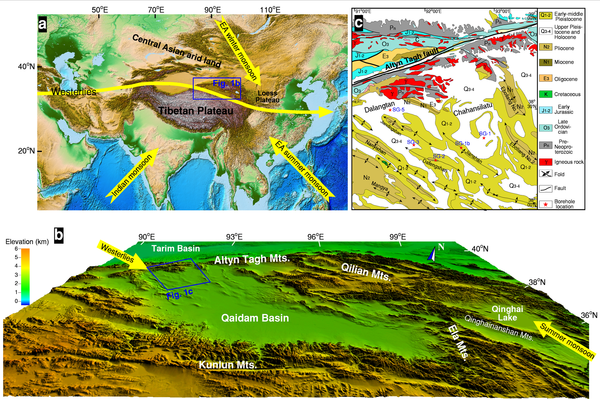
Figure 1. (color online) Digital elevation model and map of the Asian interior and its surrounding area showing the location of the Qaidam Basin and the influence of the westerlies and Asian monsoon (a), the Qaidam Basin and the surrounding mountains (b), and the study area and boreholes in the western Qaidam Basin (c).
Irrespective of which mechanism drove the desertification of the Asian interior, Quaternary climates have experienced several significant transitions (Ruddiman and Kutzbach, Reference Ruddiman and Kutzbach1989; Clark et al., Reference Clark, Archer, Pollard, Blum, Rial, Brovkin, Mix, Pisias and Roy2006; Song et al., Reference Song, Fang, King, Li, Naoto and An2014). The drying process of central Asia has been recorded in the loess from the western Kunlun Mountains (Zan et al., Reference Zan, Fang, Yang, Nie and Li2010, Reference Zan, Fang, Yang and Yan2013), the Tianshan Mountains (Fang et al., Reference Fang, Shi, Yang, Yan, Li and Jiang2002; Song et al., Reference Song, Luo, Du, Kang, Cheng, Fu and Guo2018) and Tajikistan (Ding et al., Reference Ding, Ranov, Yang, Finaev, Han and Wang2002, Yang et al., Reference Yang, Li, Liu, Zan, Liu, Kang, Murodov and Fang2020a), the Chinese Loess Plateau (Guo et al., Reference Guo, Ruddiman, Hao, Wu, Qiao, Zhu, Peng, Wei, Yuan and Liu2002; Ding et al., Reference Ding, Derbyshire, Yang, Sun and Liu2005; Zan et al., Reference Zan, Fang, Li, Zhang, Yan and Shen2018), and the fluviolacustrine sequences of the Gobi Desert (Sun and Liu, Reference Sun and Liu2006; Chang et al., Reference Chang, An, Liu, Ao, Qiang, Song and Lai2014) from the Late Pliocene. Except for these loess aeolian and fluviolacustrine deposits, uniform and fine lacustrine detritus convey more paleoclimatic information because the lithofacies are highly correlated with climatic change (Zhang et al., Reference Zhang, Appel, Fang, Yan, Song and Cao2012b; Tan et al., Reference Tan, Zhang, Fang, Yan, Zan and Zhang2020; Yang et al., Reference Yang, Zhang, Fang, Cai and Lu2020b); however, attaining complete and continuous Quaternary lacustrine sequences from the Tibetan Plateau has been a considerable challenge owing to poor exposure of the outcrop sections.
The rhombus-shaped Qaidam Basin, the largest intermontane basin on the NE Tibetan Plateau, is located in the transitional zone between the modern westerlies and the East Asian monsoon (Fig. 1). The westerly dominated climate controls the modern ecological environment of the western part of the basin, whereas the East Asian summer monsoon extends only to its southeastern section (Yang et al., Reference Yang, Zhang, Fang, Cai and Lu2020b). The basin has thick and continuous sediments from the Eocene that record the interactions of tectonic uplift, Asian interior aridification, and global change (Huang et al., Reference Huang, Huang, Ma and Huang1996; Xia et al., Reference Xia, Zhang, Yuan, Fan and Zhang2001; Wang and Burchfiel, Reference Wang and Burchfiel2004; Zhang et al., Reference Zhang, Appel, Fang, Song, Setzer, Herb and Yan2014; Fang et al., Reference Fang, Galy, Yang, Zhang, Ye and Song2019).
To better understand the Quaternary climatic changes in the Asian interior, multiple boreholes, named SG-1, SG-1b, SG-2, and SG-3, have been extracted from the western Qaidam Basin since 2008 by a Sino-German research team in a joint scientific drilling framework. Numerous high-resolution paleoclimatic records, such as lithological transitions, grain size, geochemical proxies, and pollen spectra, have been successfully reported from the cores of these deep boreholes. Precise dating of magnetostratigraphic ages for the sediments from these boreholes is crucial for our understanding of Asian interior aridification, global cooling, and tectonic uplift of the NE Tibetan Plateau. In addition, research into the process and mechanism of long-term changes in rock magnetism has remained sparse in the fluvial and lacustrine deposits, hampering our knowledge of the paleoclimatic evolution in the Qaidam Basin (Zhang et al., Reference Zhang, Appel, Fang, Yan, Song and Cao2012b; Tan et al., Reference Tan, Zhang, Fang, Yan, Zan and Zhang2020). Here, we present the magnetostratigraphic results of the SG-5 borehole core to provide accurate age constraints on the stratigraphic framework. We use rock magnetic records to reconstruct the evolution of the Quaternary paleoclimate in central Asia.
GEOLOGICAL SETTING
The Qaidam Basin, with an average elevation of ~2800 m, is in the eastern section of the arid Asian interior. It is bordered by the Qilian Mountains to the north, the Kunlun Mountains to the south, the Altyn Tagh Mountains to the west, and the Ela Mountains to the east, with average elevations of ~4000–5000 m asl (Fig. 1a). The eastern Qaidam Basin, with a mean annual precipitation of 100–200 mm, contains widely distributed salt lakes and marshes. The western Qaidam Basin is extremely dry, with a mean annual precipitation of <20 mm, and is dominated by modern desert with gravel, sand deserts, and Yardang landforms. The whole basin has a mean annual temperature of 2–4°C, and the annual mean amount of evaporation reaches 3298 mm (Wang et al., Reference Wang, Fang, Appel and Song2012).
The Qaidam Basin has accumulated thick and continuous alluvial, fluviolacustrine, and lacustrine sediments since the Eocene. During its formation, the depocenter was located in its western part (Xia et al., Reference Xia, Zhang, Yuan, Fan and Zhang2001; Wang et al., Reference Wang, Xu, Zhou, Wan and Burchfiel2006; Yin et al., Reference Yin, Dang, Zhang, Chen and McRivette2008). With later tectonic uplift of the Kunlun and Altyn Tagh Mountains around the margins of the western basin, this part was subjected to strong tectonic compression and crustal shortening, causing multiple eastward shift steps of the depocenter and resulting in large variations in sediment thickness at different locations (Xia et al., Reference Xia, Zhang, Yuan, Fan and Zhang2001; Wang et al., Reference Wang, Xu, Zhou, Wan and Burchfiel2006; Zhou et al., Reference Zhou, Xu, Wang, Gao and Yin2006; Yin et al., Reference Yin, Dang, Zhang, Chen and McRivette2008). Since the Pliocene, the formerly uniform larger depocenter has broken and separated into several subdepressions (sub-basins), and closed paleolakes have formed (Yang et al., Reference Yang, Zhang, Fang, Cai and Lu2020b). These sub-basins have primarily deposited evaporites from the Late Pliocene (Shen et al. Reference Shen, Cheng, Le and Shen1993; Cai et al., Reference Cai, Fang, Wu, Miao and Appel2012; Wang et al., Reference Wang, Fang, Appel and Song2012). During the late Quaternary, the main depocenter of the basin shifted to the east (Gu et al., Reference Gu, Xu, Xue, Di, Yang, Di and Zhao1990; Huang et al., Reference Huang, Huang, Ma and Huang1996; Xia et al., Reference Xia, Zhang, Yuan, Fan and Zhang2001; Wang et al., Reference Wang, Xu, Zhou, Wan and Burchfiel2006). Meanwhile, the basin climate became drier, saline lake areas shrank, and the surface of the western basin became a playa with salt crusts (Wang et al., Reference Wang, Fang, Appel and Song2012).
The 6000-m-thick continuous sequence of Cenozoic sediments in the western Qaidam Basin was derived from the detritus of the surrounding mountains (Xia et al., Reference Xia, Zhang, Yuan, Fan and Zhang2001; Yin et al., Reference Yin, Rumelhart, Bulter, Cowgill, Harrison, Foster and Ingersoll2002; Liu et al., Reference Liu, Fang, Gao, Wang, Zhang, Miao, Liu and Zhang2009) and records paleoclimatic evolution in the Asian interior and the basin's deformation history associated with major tectonic upliftin the NE Tibetan Plateau (Yin et al., Reference Yin, Rumelhart, Bulter, Cowgill, Harrison, Foster and Ingersoll2002; Wang and Burchfiel, Reference Wang and Burchfiel2004; Wang et al., Reference Wang, Fang, Appel and Song2012; Zhang et al., Reference Zhang, Fang, Song, Appel, Yan and Wang2013, Reference Zhang, Appel, Fang, Setzer, Song, Meng and Yan2020). While thick layers of sandstone and conglomerate have characterized the margins of the western Qaidam Basin since the Late Pliocene, the thick and fine mudstone, marl, and evaporite deposited in the basin interior (Shen et al., Reference Shen, Cheng, Le and Shen1993; Wang et al., Reference Wang, Fang, Appel and Song2012; Zhang et al., Reference Zhang, Appel, Fang, Song and Cirpka2012a) could preserve significant climate information on Asian interior aridification and even on global cooling. Fine-grained sedimentary sequences were thus obtained from four boreholes drilled in the western Qaidam Basin. The sediments were magnetostratigraphically dated to ~2.77–0.1 Ma (SG-1 core with a depth of 938 m), 7.3–1.6 Ma (SG-1b core with a depth of 732 m), 3.7–3.2 Ma (SG-2 core with a depth of 151 m), and 3.06–0.1 Ma (SG-3 core with a depth of 600 m) (Fig. 1c; Cai et al., Reference Cai, Fang, Wu, Miao and Appel2012; Zhang et al., Reference Zhang, Appel, Fang, Yan, Song and Cao2012b, Reference Zhang, Appel, Fang, Song, Setzer, Herb and Yan2014, Reference Zhang, Appel, Fang, Setzer, Song, Meng and Yan2020). In thisarticle, the rock magnetic records are used to understand paleoclimatic changes in central Asia during the Quaternary, based on the accurate magnetostratigraphic ages of the SG-5 borehole core in the western Qaidam Basin.
MATERIALS AND METHODS
The SG-5 borehole (38°35.587′N, 91°28.234′E) was drilled on a flat playa in the Dalangtan salt lake in the western Qaidam Basin (Fig. 1). The core reached a depth of 590 m, with an average sedimentary recovery rate of ~90%. Its sedimentary sequence was dominated by gray clay silt, dark gray clay, calcareous mudstone, and gray-white halite, indicating a shallow-water lacustrine or fluvial environment throughout. The upper part of the core (0–225 m) is mainly composed of distinct thick gray-white halite and gray clay with a small amount of mirabilite and gypsum, which is an indicative of a shallow salt lake. The middle part (225–452 m) is dominated by gray or dark gray clay, clay silt, and calcareous mudstone interbedded with thin gray-white halite, indicating a transitional environment between shallow brackish lake and salt lake. The lower part of the core (452–590 m) is mainly characterized by coarse brownish yellow sandstone, with conglomerates in the bottom, gray clay and mudstone in the middle, and gray siltstone and fine sandstone in the upper sections; these can be interpreted as braided river and overbank deposits.
The degree of cementation of the sandstone and conglomerates in the bottom of the SG-5 borehole is weak; therefore, all samples were taken from the fine sediments at depths ranging from 0 to 511 m. A total of 1030 cubic (2 × 2 × 2 cm) specimens at ~50-cm intervals and 1373 specimens at ~30-cm intervals were taken for the magnetostratigraphic study and the rock magnetic analysis, respectively. All the magnetostratigraphic samples were subjected to stepwise alternating field demagnetization (AFD) at fields up to 140 mT with 4- or 20-mT increments. All remanence measurements were made using a 2 G Enterprises Model 755 cryogenic magnetometer installed in a field free space (<150 nT) at the Institute of Tibetan Plateau Research, Chinese Academy of Sciences. The rock magnetic specimens were measured using a Bartington MS2 susceptometer at frequencies of 470 Hz and 4700 Hz. The values of mass-specific frequency-dependent magnetic susceptibility (χfd) and percentage frequency-dependent magnetic susceptibility (χfd %) were defined as χfd = χ470Hz - χ4700Hz and χfd % = (χ470Hz - χ4700Hz) / χ470Hz × 100%. The anhysteretic remanent magnetization (ARM) was measured using a 100-mT peak alternating field and a superimposed 0.05 mT direct current biasing field by a D-2000 alternating demagnetizer, and the susceptibility of ARM (χARM) was calculated as ARM/0.05 mT. The saturation isothermal remanent magnetization (SIRM) was acquired with an IM-10-30 pulse magnetizer in a magnetic field of 1 T.
The temperature-dependent magnetic susceptibilities (χ-T) of the typical samples, each of which had a mass of ~0.2 g, were measured under an argon atmosphere to avoid oxidation during heating from room temperature to ~700°C and then cooled to room temperature using a MFK1-FA Kappabridge and a CS-4 high-temperature furnace (Agico Ltd., Brno, Czech Republic). Magnetic hysteresis parameters, including hysteresis loops and isothermal remanent magnetization (IRM) acquisition curves, were measured on a Lakeshore vibrating sample magnetometer 8600 with a maximum applied field approaching 1 T. The paramagnetic susceptibilities of the hysteresis loops were removed by slope correction between 800 and 1000 mT. Several magnetic parameters were determined, including the saturation magnetization (Ms), saturation remanent magnetization, and coercivity (Bc).
RESULTS
χ-T curves, hysteresis loop, and IRM acquisition curves
All χ-T curves generally exhibited higher susceptibility to cooling than heating (Fig. 2), possibly indicating that stronger magnetic minerals, such as magnetite, which formed during cooling oxidize from iron-containing paramagnetic minerals existing in the sediments. For the samples with high and low magnetic susceptibility (χ) values, almost all heating curves show a peak value in susceptibility between 300 and 500°C (Fig. 2).This can be interpreted as the formation of ferrimagnetic minerals, such as magnetite, by the oxidization of iron sulfides during heating (Roberts et al., Reference Roberts, Cui and Verosub1995). Obvious losses of susceptibility occurred at ~580°C, and minimum values above 690°C were observed, implying that the samples carry magnetite and hematite.

Figure 2. High-temperature magnetic susceptibility (χ-T) curves of typical samples from the borehole SG-5 core. (a) Typical data from the samples with a low magnetic susceptibility (χ) value. (b) Typical data from the samples with a high χ value. Red and blue lines represent heating and cooling χ-T curves, respectively; the inset small plots show the amplified scales for heating χ-T curves. (For interpretation of the references to color in this figure legend, the reader is referred to the web version of this article.)
After paramagnetic slope correction, all hysteresis loops were almost closed before reaching 300 mT, and the Bc values were lower than 40 mT, indicating the dominance of soft ferrimagnetic minerals. In addition, the Ms of the samples with a low χ value are less than 6.5 × 10⁻³ Am2/kg (Fig. 3a), considerably lower than that of the samples with a high χ value (Ms >16.0 × 10⁻³ Am2/kg) (Fig. 3b), implying that the concentration of ferrimagnetic minerals in the latter is higher than in the former.

Figure 3. Magnetic hysteresis loops (after slope correction) from the samples with a low χ value (a) and a high χ value (b) from the SG-5 borehole core.
The IRM acquisition curves show rapid increases below 200 mT, and most samples acquired at least 90% of SIRM at ~300 mT (Fig. 4), further demonstrating that magnetic minerals for the SG-5 borehole core were dominated by low-coercivity minerals. Nevertheless, IRMs in individual samples still have no complete saturation value when the applied field gradually increased to 1 T (Fig. 4), reflecting the presence of hard magnetic minerals. The maximum of SIRM is <1. 5 × 10⁻³ Am2/kg for the samples with a low χ value and >2.5 × 10⁻³ Am2/kg for those with a high χ value (Fig. 4), also indicating that a high concentration of ferrimagnetic minerals exists in samples with a high χ value, which is consistent with the results of the hysteresis loops.

Figure 4. Isothermal remanent magnetization acquisition curves from samples with a low χ value (a) and a high χ value (b) for the SG-5 borehole core.
Alternating field demagnetization characteristics and magnetostratigraphy
Based on the aforementioned results on the soft magnetic mineral for the dominant contributions of the SG-5 borehole core, which is similar to rock magnetic results from the SG-1, SG-1b, and SG-3 borehole cores (Zhang et al., Reference Zhang, Appel, Fang, Song and Cirpka2012a, Reference Zhang, Appel, Fang, Yan, Song and Cao2012b, Reference Zhang, Appel, Fang, Setzer, Song, Meng and Yan2020; Tan et al., Reference Tan, Zhang, Fang, Yan, Zan and Zhang2020), AFD was applied to analyze the characteristic remanent magnetization (ChRM) component. The AFD plots show the soft component was a relatively softer magnetic mineral or a viscous overprint demagnetized before 20 mT, and the ChRMs were clearly isolated and pointed directly toward the origin in the Zijderveld diagram after 20 mT (Fig. 5). Relatively higher ChRM values imply that the small residual remanence after 140 mT resides in the highest coercive hematite. These observations, in agreement with the χ-T curves, IRM, and magnetic hysteresis loops (Figs. 2–4), confirm that the major contributors of ChRMs are magnetite, followed by small amounts of hematite.

Figure 5. Results of alternating field demagnetization for samples with a low χ value (a) and a high χ value (b) from the SG-5 borehole core. Open and closed circles represent vertical and horizontal projections, respectively.
The ChRM directions were calculated by at least four consecutive demagnetization steps over 30 mT. Directions with a maximum angular deviation of >15° were rejected. A total of 797 samples (out of 1030 measured samples) had stable ChRM directions; the declinations were insignificant, with no control on the core azimuth during drilling, and only the inclinations were further used to interpret magnetostratigraphic ages. At least two consecutive samples with the same polarity were used to define a polarity interval as an excursion or event. A total of 34 normal (N1–N17) and reversed (R1–R17) polarity zones were identified in the SG-5 borehole (Fig. 6).

Figure 6. (color online) Lithology, magnetostratigraphy (black/white bars indicate normal/reversed polarity), and records of χ, mass-specific frequency-dependent magnetic susceptibility (χfd), percentage frequency-dependent magnetic susceptibility (χfd %), saturation isothermal remanent magnetization (SIRM), and susceptibility of mass-specific anhysteretic remanent magnetization (χARM) for the SG-5 borehole core. Note that the bolded black line in the χ record represents the curve of an 11-point running average; the dashed gray lines represent the general change trend of rock magnetic records; GPTS = Geomagnetic Polarity Time Scale. Note that all the data for this figure can be found in the supplementary material.
χ, χfd, χfd %, χARM, and SIRM
The values of mass-specific χ in the SG-5 borehole core vary from 0.86 × 10⁻⁸ m3/kg to 4.93 × 10⁻⁷ m3/kg, with subtle increasing and decreasing trends at depths of ~220 m along the entire core (Fig. 6). Mudstone and siltstone layers intercalated with salt-bearing layers have much higher χ values than those of evaporite layers. The χfd and χfd % are generally low, with values of <0.5 × 10⁻⁸ m3/kg and <5%, with no large variations over the entire core (Fig. 6), indicating that the contribution of ultrafine ferrimagnetic minerals to χ variations can be neglected.
SIRM is an effective index to estimate the total concentration of magnetic minerals with grain sizes above the threshold of superparamagnetic and single-domain (SD) grains (Thompson and Oldfield, Reference Thompson and Oldfield1986; Evans and Heller, Reference Evans and Heller2003), and χARM is usually sensitive to SD grains (Maher, Reference Maher1988; Evans and Heller, Reference Evans and Heller2003). The overall trends of SIRM and χARM in the SG-5 borehole core, with their values varying from ~0.18–159 × 10-4 Am2/kg and ~0.05–20.8 × 10⁻⁷ m3/kg, respectively, show similar variations of χ across the entire core (Fig. 6), indicating that the concentrations of magnetic minerals with SD grains result in variations of χ in the sediments of the paleolake in the western Qaidam Basin; this was similar to the previous rock magnetic analyses from the SG-1 and SG-3 boreholes (Zhang et al., Reference Zhang, Appel, Fang, Song and Cirpka2012a; Tan et al., Reference Tan, Zhang, Fang, Yan, Zan and Zhang2020).
DISCUSSION
Magnetostratigraphic age constraint on the strata since the Late Pliocene
The SG-5 borehole site is located in the western part of the Dalangtan depression, which has a flat surface covered by a salt crust. Its topmost sediments are presumed to be of subrecent age. Previous work demonstrated that surface age was dated at ~0.1 Ma by the magnetostratigraphy of the depression and its adjacent Chahansilatu-deposited zones with the desiccated playa (Shi et al., Reference Shi, Zheng, Li, Wang, Hou and Ma2010; Cai et al., Reference Cai, Fang, Wu, Miao and Appel2012; Zhang et al., Reference Zhang, Appel, Fang, Yan, Song and Cao2012b). OSL and U-Th dating also constrained the playa salt crust of the western Qaidam Basin to be ~0.1 Ma (Han et al., Reference Han, Ma, Lai, Appel, Fang and Yu2013). Based on the top salt crust, the observed polarity zones (N1–N17 and R1–R17) from the SG-5 borehole core correlate well with the chrons C1n–C2An.1r of the Geomagnetic Polarity Time Scale (GPTS) 2012 (Fig. 6; Gradstein et al., Reference Gradstein, Ogg, Schmitz and Ogg2012). The top normal polarity zones N1–N6 most likely correspond to the Brunhes normal polarity epoch; the other short reverse polarity zones R1–R5 can be interpreted as CR0, Portuguese margin, Delta, Levantine, Emperor, and Big Lost or Delta events, respectively (Fig. 6; Champion et al., Reference Champion, Lanphere and Kuntz1988; Langereis et al., Reference Langereis, Dekkers, Lange, Paterne and Santvoort1997; Lund et al., Reference Lund, Stoner, Channell and Acton2006; Laj and Channell, Reference Laj, Channell and Kono2007; Thouveny et al., Reference Thouveny, Bourlès, Saracco, Carcaillet and Bassinot2008; Gradstein et al., Reference Gradstein, Ogg, Schmitz and Ogg2012). The reverse polarity zones R6–R16 can be interpreted as the Matuyama polarity epoch. The normal polarity zones N7–N10, N13, and N14 within the Matuyama epoch can be readily correlated with Jaramillo, Cobb Mountain, Bjorn, Gardar, Olduvai, and Reunion normal subchrons, respectively. The lowest polarity zones are characterized by one long normal and one short reverse polarity zone, N17 and R17, which likely record the middle–upper part of the Gauss normal polarity epoch, such as C2An.1n and C2An.1r. Assuming these correlations, the SG-5 borehole core is determined to have an age ranging from 0.1 to 3.0 Ma, with the Brunhes/Matuyama and Matuyama/Gauss boundaries located at depths of 94.5 and 447.0 m, respectively. The observed short normal polarity intervals N6, N11, N14, and N15 remain less secure in our correlation, but this should not grossly affect the above correlations with the GPTS 2012.
Paleomagnetic investigations of multiple borehole cores from the adjacent area also show a similar magnetostratigraphic age framework (Fig. 7a–e; Cai et al., Reference Cai, Fang, Wu, Miao and Appel2012; Zhang et al., Reference Zhang, Appel, Fang, Yan, Song and Cao2012b, Reference Zhang, Appel, Fang, Song, Setzer, Herb and Yan2014, Reference Zhang, Appel, Fang, Setzer, Song, Meng and Yan2020). Based on the proposed magnetostratigraphic age interpretations of the SG-1, SG-1b, and SG-2 borehole strata, the youngest ages of the centers of the Dafengshan and Jianshan anticlines are 1.6 and 3.2 Ma (Fig. 7f), indicating unroofing since the Late Pliocene strata took place at ~3.2 and ~1.6 Ma (Zhang et al., Reference Zhang, Appel, Fang, Setzer, Song, Meng and Yan2020). The composite lithology analysis shows that the SG-1 and SG-3 borehole cores from the Dalangtan and Chahansilatu depressions were characterized by gray mudstone gypsum and halite before 1.2 Ma (Fig. 7c, e, f), representing a saline paleolake environment. The lithofacies analysis of the SG-1b and SG-2 borehole cores imply that the Dafengshan and Jianshan anticline hinges were shallow paleolake depositional environments before 1.2 Ma, characterized by clay, mudstone, and marl intercalated with scattered gypsum and thin salt layers (Fig. 7a, f).

Figure 7. (color online) Correlations of lithologies and magnetostratigraphies of the borehole cores, with the GPTS from the borehole cores in the western Qaidam Basin (A–E) and dynamic models for the change of the lithology and shifts of the sedimentary center in the paleolake of the western Qaidam Basin before and after 1.2 Ma (F).
It is generally considered that the salt beds were synchronously deposited in the central part of the western Qaidam Basin, but this is not the case from the foregoing magnetostratigraphic strata. The most reasonable explanation for this case is that offlap growth strata became progressively younger from the southwest to northeast in the center of the western basin owing to a strong fault basinward propagation (Zhang et al., Reference Zhang, Appel, Fang, Song, Setzer, Herb and Yan2014, Reference Zhang, Appel, Fang, Setzer, Song, Meng and Yan2020). This resulted in the anticline hinge becoming the lakeshore area and allowing the inflow of fresh water (Fig. 7f), confirmed by the conglomerates deposited at the SG-2 and SG-5 boreholes by a braided river channel (Fig. 7a, b). The thickness of the salt layers increased gradually after 1.2 Ma in the western Qaidam Basin, regardless of whether it was the hinge or limb of the anticline (Fig. 7b, c, e). The pattern and migration of paleorivers could have highly influenced the salt formation in the depressions (Yuan et al., Reference Yuan, Huo and Cai1983; Duan and Hu, Reference Duan and Hu2001; Wang et al., Reference Wang, Xu, Zhou, Wan and Burchfiel2006), whereas the persistent inflow of snow melt from the Kunlun, Altyn Tagh, and Qilian Mountains have not suppressed the formation of salt layers in the Quaternary depressions. Thus, the comparisons of the magnetostratigraphic ages from the different locations of the western Qaidam Basin can provide more precise time constraints for the climatic and tectonic strata.
The magnetostratigraphic ages on the top of the SG-1, SG-3, and SG-5 borehole cores demonstrate that the termination of evaporite deposition occurred at ~0.1 Ma in the western Qaidam Basin (Fig. 8; Cai et al., Reference Cai, Fang, Wu, Miao and Appel2012; Zhang et al., Reference Zhang, Appel, Fang, Yan, Song and Cao2012b); this is also supported by the OSL and U-Th dating of the playa salt crust (Han et al., Reference Han, Ma, Lai, Appel, Fang and Yu2013). Owing to strong rapid uplift since the mid-Pleistocene, syntectonic growth strata became more prominent. The basin depocenter shifted eastward and ultimately withdrew from the Dalangtan and Chahansilatu depressions at 0.1 Ma (Zhang et al., Reference Zhang, Appel, Fang, Song, Setzer, Herb and Yan2014), leading to the formation of the largest saline lake in the Qarhan depression in the eastern Qaidam Basin. After 0.1 Ma, most of the western basin had become a denudation area and suffered erosion by the strong westerlies and regional winds, finally forming the present Yardang landform or salt crust (Han et al., Reference Han, Ma, Lai, Appel, Fang and Yu2013; Zhang et al., Reference Zhang, Appel, Fang, Setzer, Song, Meng and Yan2020). The magnetostratigraphic age constraints on the lithofacies demonstrate that, while tectonic uplifts contributed to the shifts in the depocenter of the basin, they did not transform its climate pattern (Zhang et al., Reference Zhang, Appel, Fang, Song, Setzer, Herb and Yan2014; Lu et al., Reference Lu, Fang, Appel, Wang, Herb, Han, Wu and Song2015; Yang et al., Reference Yang, Zhang, Fang, Cai and Lu2020b). Asian interior aridification and global cooling were the significant influencing factors of the basin's environment.

Figure 8. (color online) Comparisons of climatic and environmental records in the western Qaidam Basin with global climatic records since 3.0 Ma. (a) χ of the borehole SG-5 core, including an 11-point running average line. (b) Manganese (Mn) concentrations from the citrate-bicarbonate-dithionite extraction (MnCBD), including an 11-point running average line (Yang et al., Reference Yang, Fang, Appel, Galy, Li and Zhang2013). (c, d) Artemisia/Chenopodiaceae (A/C) and Chenopodiaceae and Ephedraceae (C+E) xerophytic taxa () records (Cai et al., Reference Cai, Fang, Wu, Miao and Appel2012). (e) Chloride (Cl-) content representing paleosalinity evolution of the western Qaidam Basin (Guo et al., Reference Guo, Liu, Huang, Yu, Wang and Zhang2018). (f, g) δ18O and δ2H values of fluid inclusions in gypsum crystals (Li et al., Reference Li, Li, Fang, Zhang, Zhang and Liu2017). (h) Global marine sediment δ18O record from LR04 (Lisiecki and Raymo, Reference Lisiecki and Raymo2005). The dashed gray line represents the change trend of each record; SMOW = Standard Mean Ocean Water.
Transition of the Quaternary paleoclimate in the western Qaidam Basin
The lacustrine sediments from the western Qaidam Basin are closely related to the evolution of the westerlies system associated with global change. The χ of the fine sediments has been regarded as a proxy index of the intensity of the westerly jets and global cooling (Zhang et al., Reference Zhang, Appel, Fang, Song and Cirpka2012a; Tan et al., Reference Tan, Zhang, Fang, Yan, Zan and Zhang2020; Yang et al., Reference Yang, Zhang, Fang, Cai and Lu2020b) and/or the paleoclimatic changes of the Qaidam Basin driven by the closure of the Indonesian seaway (Su et al., Reference Su, Nie, Meng, Heermance, Gong, Luo, Wang, Zhang and Garzione2019). Based on the magnetostratigraphic age constraints on the multiple borehole cores, our observed χ gradually increased between 3.0 and 1.2 Ma, attained its peak at 1.2 Ma, and subsequently showed a gradual decline (Fig. 8a). Since χ is a significant climate signal, we infer that one climate transition event occurred in the western Qaidam Basin at 1.2 Ma.
From the rock magnetic results presented above, the variation of χ in the SG-5 borehole core appears to be caused by the relative concentration of magnetic minerals in the clastic deposits, which is similar to the inferences from the SG-1 borehole cores. From the overall changing trend of χ, the SG-5 boreholes exhibited the same long-term decrease in the anticline limb of the western Qaidam Basin as the SG-1 and SG-3 boreholes (Zhang et al., Reference Zhang, Appel, Fang, Song and Cirpka2012a; Tan et al., Reference Tan, Zhang, Fang, Yan, Zan and Zhang2020), while the anticline hinge as the SG-5 borehole showed a trend of first increasing and then decreasing values of χ, with the transitional boundary at 1.2 Ma. The evaporite content from all these borehole cores also gradually increased after 1.2 Ma (Fig. 8b, c, e); therefore, the two original models on low-temperature oxidation or provenance change (Zhang et al., Reference Zhang, Appel, Fang, Song and Cirpka2012a) should be reconsidered. Low-temperature oxidation can lead to the formation of hematite via preexisting magnetite or maghemite. The provenance alternations caused by the glacial-interglacial cycles during the Quaternary should transform the type of magnetic mineral or the size of magnetic grains, which is inconsistent with no more hematite in our SG-5 borehole and dominant SD grains in the SG-3 borehole (Tan et al., Reference Tan, Zhang, Fang, Yan, Zan and Zhang2020). In addition, the pedogenesis model for magnetic properties is only present in the floodplain within the fluviolacustrine sediments (Ao et al., Reference Ao, Deng, Dekkers and Liu2010) or in the loess-paleosol (Zan et al., Reference Zan, Fang, Li, Zhang, Yan and Shen2018). Thus, this model is only one explanation for Asian interior aridification and global cooling for the χ variations in the western Qaidam Basin.
During the Pliocene to Quaternary, the climate turned toward dry and cold conditions (Cai et al., Reference Cai, Fang, Wu, Miao and Appel2012; Wang et al., Reference Wang, Fang, Appel and Zhang2013; Han et al., Reference Han, Fang, Ye, Teng and Zhang2014; Guo et al., Reference Guo, Liu, Huang, Yu, Wang and Zhang2018), which played an important role for salt formation in the Qaidam Basin. The salt deposits altered the relative content of the detritus and further diluted the concentration of magnetic minerals. Before 1.2 Ma, the dry, cold climate resulted in the gradual formation of thick evaporite layers and a decrease in the proportion of detrital material in the anticline limb of the western Qaidam Basin, as indicated by the decrease of χ values in the SG-1 borehole at the center of the Chahansilatu depression (Fig. 7f). In comparison with the anticline limb in the middle of the paleolake, the anticline hinge, which had high altitude and was the paleolakeshore, deposited massive detritus denuded by strong cryoclastic erosion during the dry, cold phase, and aeolian sediments were deposited by the westerly jet and supply of snowmelt fresh water, which made it very difficult to form evaporite beds and led to the gradual increase of χ values in the SG-5 borehole.
After 1.2 Ma, accompanied by a drier and colder climate in the Asian interior in the late Quaternary (Lü et al., Reference Lü, Fang, Mason, Li and An2001; Fang et al., Reference Fang, Shi, Yang, Yan, Li and Jiang2002; Ding et al., Reference Ding, Derbyshire, Yang, Sun and Liu2005; Wu et al., Reference Wu, Fang, Ma, Herrmann, Mosbrugger, An and Miao2007; Zan et al., Reference Zan, Fang, Yang, Nie and Li2010), the whole western Qaidam Basin began to turn into a large area of salt-lake deposits, including the limb and hinge of the anticline, and the paleolake began to dry (Fig. 7f). Meanwhile, a high concentration of evaporites here diluted the relative content of detritus, indicating a lower χ value after 1.2 Ma. This χ variation mechanism on Asian interior aridification and global cooling is reasonable for long-term changing trends of χ in different regions of the western Qaidam Basin. Though rapid tectonic uplifts amplified the glaciation and erosion of the surrounding mountains and adjusted the shifts of the basin depocenter, they were not enough to change the aridification environment of the whole basin. Thus, we suggest that at 1.2 Ma, the western Qaidam Basin experienced a significant climatic transition under Asian interior aridification and global cooling.
The mid-Pleistocene climate transition between 1.2 and 1.1 Ma brought the global climate system into the late Pleistocene ice ages (Ruddiman et al., Reference Ruddiman, Raymo, Martinson, Clement and Backman1989; Mudelsee and Schulz, Reference Mudelsee and Schulz1997; Berger et al., Reference Berger, Li and Loutre1999; Schmieder et al., Reference Schmieder, von Dobeneck and Bleil2000; Clark et al., Reference Clark, Archer, Pollard, Blum, Rial, Brovkin, Mix, Pisias and Roy2006), and the Asian interior experienced further aridification (Fang et al., Reference Fang, Li and Van der Voo1999; An et al., Reference An, Kutzbach, Prell and Porter2001; Han et al., Reference Han, Fang and Berger2012; Song et al., Reference Song, Fang, King, Li, Naoto and An2014). In the western Qaidam Basin, the manganese content analyzed by the citrate-bicarbonate-dithionite extraction showed a gradual increase before 1.2 Ma, with peak values at 1.2 Ma and a subsequent decreasing trend after 1.2 Ma (Fig. 8b; Yang et al., Reference Yang, Fang, Appel, Galy, Li and Zhang2013, Reference Yang, Fang, Koutsodendris, Ye, Yang, Zhang, Liu and Gao2016), indicating paleolake redox changes and a drying climate. The ratios of Artemisia/Chenopodiaceae (Fig. 8c) and the value of xerophytic taxa from Chenopodiaceae and Ephedraceae (Fig. 8d) also exhibited a significant climate change at 1.2 Ma (Cai et al., Reference Cai, Fang, Wu, Miao and Appel2012). The chloride content, a common lake-water paleosalinity index, exhibited abrupt increases at ~1.2 Ma, indicating the wide distribution of the playa in the western Qaidam Basin after 1.2 Ma due to global cooling and Asian interior aridification or the eastward shift of the basin depocenter under tectonic uplifts (Fig. 8e; Guo et al., Reference Guo, Liu, Huang, Yu, Wang and Zhang2018). The δ18O and δ2H values of fluid inclusions from primary gypsum crystals recording lake-water conditions indicated an important variation with a cold and dry event at 1.2 Ma (Fig. 8f, g; Li et al., Reference Li, Li, Fang, Zhang, Zhang and Liu2017).
These findings on climate change at 1.2 Ma in the western Qaidam Basin are synchronous with long-term global cooling, with fluctuations at 1.2 Ma inferred from the deep-sea oxygen isotope record (Fig. 8h; Lisiecki and Raymo, Reference Lisiecki and Raymo2005). In summary, χ and other climatic records suggest that the Quaternary climate of the western Qaidam Basin experienced an important transition at 1.2 Ma related to Asian interior aridification and global cooling.
CONCLUSIONS
Magnetic polarity stratigraphic analysis of the stratigraphic sequence from the SG-5 borehole yield estimated ages between 3.0 and 0.1 Ma. Based on magnetostratigraphic ages of multiple borehole cores, the initial salt beds in the limb of anticline are older than in the hinge of anticline in the western Qaidam Basin. The strata for the obvious alterations of evaporite content and χ values are constrained by the magnetostratigraphic age to 1.2 Ma. A comparison of magnetostratigraphic, χ, pollen, salt ion, and grain-size results from adjacent borehole cores demonstrate that the Quaternary climate of the western Qaidam Basin experienced a significant environmental transition at 1.2 Ma related to Asian interior aridification and global cooling.
Supplementary Material
To view supplementary material for this article, please visit https://doi.org/10.1017/qua.2021.15
Acknowledgments
We especially thank Zhao Yan, Sun Shurui, Tian Qian, Yang Rongsheng, Yang Yongpeng, Li Yuwen, and Lu Yin for the cutting and sorting of the cores from the SG-5 borehole. We are grateful to Editor Derek Booth, Reviewer John Dodson, and an anonymous reviewer for the constructive comments and improving the English.
Financial Support
This work was cosupported by the National Natural Science Foundation of China (grants 41672358, 41620104002, 41872098), the Second Tibetan Plateau Scientific Expedition and Research (grant 2019QZKK0707), the Strategic Priority Research Program of the Chinese Academy of Sciences (grant XDA20070201), the National Basic Research Program of China (grant 2017YFC0602803), and the German Ministry for Education and Research BMBF within WTZ Zentralasien (grant 03G0805A).


