


Introduction
In comparison to the wider Fertile Crescent, the archaeology of the Neolithic period in Iran is poorly understood. The best researched areas, however, are in the central Zagros Mountains, and have provided evidence for the origins of sedentism and agriculture in highland areas (Figure 1). Recent data document early Neolithisation in the central Zagros Mountains commencing by the end of the Younger Dryas (c. 11 000–9700 BC) (Matthews et al. Reference Matthews, Matthews and Mohammadifar2013; Riehl et al. Reference Riehl, Zeidi and Conard2013; Darabi Reference Darabi2015). Similarly, recent excavations in the southern Zagros suggest that this area could have played a fundamental role in the Neolithisation of the wider region (Azizi Kharanaghi Reference Azizi Kharanaghi, Nashli, Nishiaki, Matthews and Nashli2013; Tsuneki Reference Tsuneki, Matthews and Fazeli Nashli2013). In contrast, our current knowledge of the adjacent lowlands of south-western Iran relies on the evidence of a few Neolithic sites, mostly excavated during the 1960s–1970s (Hole et al. Reference Hole, Flannery and Neely1969; Hole Reference Hole1977; Alizadeh Reference Alizadeh2003).

Figure 1. The location of Tapeh Mahtaj and other Early Neolithic sites in the western, northern, central and southern Zagros and nearby lowlands (modified after Matthews et al. Reference Matthews, Matthews and Mohammadifar2013: 2 & fig. 1.1).
These lowlands, geomorphologically oriented north-west to south-east, extend from the Mehran Plain to the Zohreh Plain (Kouchoukos & Hole Reference Kouchoukos, Hole, Abdi and Miller2003; Moghaddam Reference Moghaddam and Potts2012a & Reference Moghaddamb), and are delimited to the north by the first folds of the Zagros range and to the south by several low, outlying folds. To the south and south-east, the region is bounded by the Persian Gulf (Moghaddam Reference Moghaddam and Potts2012a: 514). Along the tectonic uplift, Quaternary alluvial sedimentation undoubtedly played an important role in the formation of these lowland plains. While alluvial fans were and are an active factor in the development of Upper Khuzestan, the Lower Khuzestan plain was affected by rising sea levels during the Early and Middle Holocene (Lambeck Reference Lambeck1996). Recently, the role of sea-level change has been addressed in relation to early occupation of the Persian Gulf basin during the Late Pleistocene–Early Holocene (Rose Reference Rose2010). In this regard, the ‘[Persian] Gulf Oasis hypothesis’ suggests that Neolithisation began amongst the indigenous communities occupying oases within the lower-lying modern sea basin before spreading into the hinterlands and higher surrounding areas as a result of marine transgression during the Early Holocene (Rose Reference Rose2010). New evidence from the lowlands, however, undermines this idea, and instead emphasises the roles played by intensive connections with the highlands and the local ecological improvements that paved the ground in this regard.
Capable of sustaining both dry and irrigated agriculture, the lowlands provide easy access to three important environmental zones: lowland Mesopotamia, the highland Zagros and the Persian Gulf (Moghaddam Reference Moghaddam and Potts2012a: 515). In this article, we discuss the Early Neolithic colonisation of this low-lying region in light of new archaeological investigations. In addition, we present finds recovered from the newly excavated site of Tapeh Mahtaj, and place the results within the wider context of the Early Neolithic in south-western Iran.
Neolithic emergence in south-western Iran: the state of current research
Since the mid nineteenth century, British and predominantly French projects in Iran focused their attention on the archaeological remains of historic periods on the Susa Plain in south-western Iran (Moghaddam Reference Moghaddam and Potts2012a). In contrast, sites of earlier prehistoric date were not studied until the mid twentieth century, when initial efforts to establish a regional chronology commenced (e.g. Le Breton Reference Le Breton1957). As a general outcome of the ‘New Archaeology’ of the 1960s–1970s, problem-oriented research concentrated predominantly on the investigation of human-environment interactions. Thus, early domestication and subsistence economies became the focus of research. On a regional scale, the history of archaeological fieldwork on the Neolithic of south-western Iran is characterised by two main stages. The first is the significant amount of fieldwork undertaken during the 1960s–1970s, including excavation at the sites of Ali Kosh, Chogha Sefid, Tulaei, Chogha Mish and, briefly, at Chogha Bonut (Hole et al. Reference Hole, Flannery and Neely1969; Hole Reference Hole1974, Reference Hole1977, Reference Hole1987; Delougaz & Kantor Reference Delougaz and Kantor1996; Alizadeh Reference Alizadeh2003). The second stage, commencing in 1996 after a hiatus of more than a decade, comprises the small-scale reinvestigation of the sites of Chogha Bonut (Alizadeh Reference Alizadeh2003) and, most recently, Ali Kosh (Darabi et al. Reference Darabi, Bahramiyan, Mostafapour, Bami and Yari2017a). Of all these sites, only a few, including Ali Kosh, Chogha Bonut and Chogha Sefid, date to the Early (or Pre-Pottery) Neolithic. Further sites have recently been attributed to the Neolithic period, including Tapeh Boneh Rahimeh. The surface finds at this site are particularly promising for further investigation (see Moghaddam Reference Moghaddam2019).
The scarcity of Early Neolithic sites in south-western Iran is, in part, due to heavy sedimentation during the Holocene (Kirkby Reference Kirkby and Hole1977). The only settlements easily detectable today are those that evolved into mounded sites rising above the surrounding terrain or which were founded on natural hillocks as an adaptive response to flooding and alluviation. Additionally, some Neolithic sites, such as Chogha Bonut or Boneh Rahimeh, are buried by thick deposits of a later date and are only identifiable on the surface as result of animal burrowing or anthropogenic activity.
Generally speaking, the emergence of a Neolithic way of life in the lowlands of south-western Iran dates to the mid eighth millennium BC (Hole Reference Hole1987; Alizadeh Reference Alizadeh2003). Major questions concerning the nature of local cultural development and the impact of climate and environmental amelioration, however, still need to be addressed. Moreover, on one hand, the previously known Early Neolithic sites noted above are all located on the western plains of south-western Iran, including Susa and Deh Luran, leaving the rest of the region ‘blank’. On the other hand, the earliest known occupation on the eastern plains, such as at Ramhormoz, Behbahan and Zohreh, has previously been traced back only as far as the fifth millennium BC (see Dittman Reference Dittmann1984; Wright & Carter Reference Wright, Carter, Abdi and Miller2003; Moghaddam Reference Moghaddam and Potts2012a & b). This chronological issue emphasises the importance of evidence from the recently investigated site of Tapeh Mahtaj.
Excavation at Tapeh Mahtaj
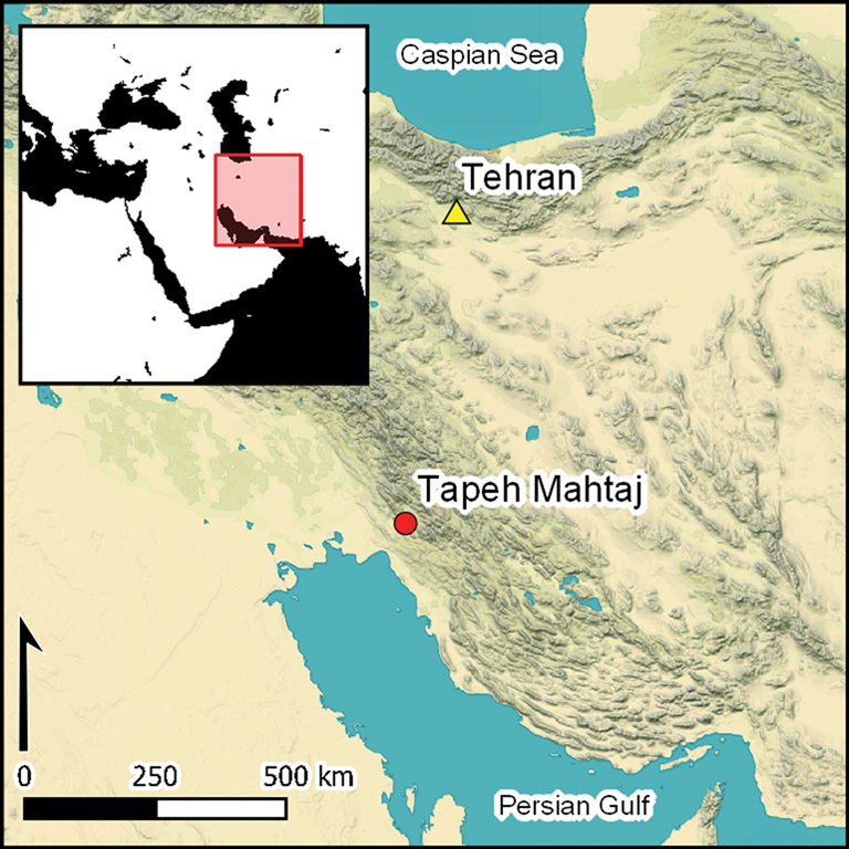
Tapeh Mahtaj (30°38′7.64″ north, 50°12′14.11″ east) is located on the southernmost end of the Behbahan Plain in south-western Iran, approximately 3.5km to the west-north-west of Behbahan city and at 310m asl. The site is situated on a natural hillock, elevated 1–2m above the surrounding fields. It should be noted that the site's surface has recently been bulldozed and that upper archaeological layers appear to have been entirely destroyed and removed.
Previous archaeological expeditions to the Behbahan Plain in the 1970s and 2000s discovered no Neolithic sites (see Nissen Reference Nissen1971, Reference Nissen1973; Dittmann Reference Dittmann1984; Abdi Reference Abdi2008). A new project launched by A. Moghaddam (Reference Moghaddam2014) aiming to locate sites dated to the Initial Village period (c. 8000–6000 BC) (for terminology, see Hole Reference Hole1987), however, identified the site of Tapeh Mahtaj, which was subsequently delineated and excavated in 2015 (Darabi et al. Reference Darabi, Aghajari, Nikzad and Bahramiyan2017b). In addition to defining the site's extent, the main objectives of the most recent work were to determine its chronology and to understand the subsistence strategies of its inhabitants. To achieve these goals, eight test pits were excavated across the site's fringe. These suggest that the site extends over an area of 150 × 70m. A trench, initially measuring 2 × 2m, was also excavated in the central part of the site, where the highest density of surface artefacts was identified (Figure 2).

Figure 2. Aerial view of Tapeh Mahtaj, showing the location of the excavation area (photograph by L. Ahmadzadeh).
The archaeological remains revealed by this initial trench were shallow, with only 0.4m of in situ deposits surviving. The trench was therefore extended to an area of 4 × 4m, and excavated down to natural soil, revealing three main architectural phases. The upper phase is marked by a scatter of pebbles, which may represent rubble from a disturbed or destroyed building, along with a high density of artefacts, including grinding implements and chipped stones distributed across the same stratigraphic layer. The middle phase is represented by the footprint of a 3 × 2m rectangular structure that was built using stones of various sizes and was oriented on a north-east to south-west alignment. It is notable that broken grinding stones and sometimes chopping tools were reused as building material in the walls of this structure (Figure 3). The lower phase is defined by the remains of a pisé (clay-built) structure with a curvilinear plan. Post-depositional factors, particularly animal burrowing, had heavily damaged this structure. Although no entrance to the structure was found, an internal fireplace was revealed in the south-west corner, adjacent to the outer wall. The trampled clay floor was sat directly above the natural soil, comprising silty clay and occasional instances of cracked mud (Darabi et al. Reference Darabi, Aghajari, Nikzad and Bahramiyan2017b).

Figure 3. Remains of the middle-phase stone structure and the presence of ground stones reused as building material (photograph by H. Darabi).
Finds
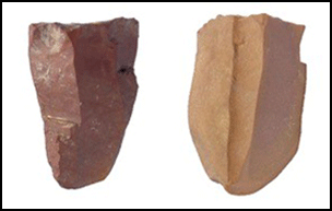
The excavations at Tapeh Mahtaj have yielded a variety of artefacts, including chipped stones, grinding stones and a number of objects made from clay, stone and bone. A total of 518 pieces of chipped stone were recovered from the three phases (Figure 4 & Table 1), comprising chert (75 per cent), flint (18 per cent), limestone (4 per cent) and obsidian (3 per cent). With the exception of the latter, all the materials appear to be of local origin, as indicated by the predominance of cortical cores and ‘tested' (i.e. their suitability for use as a raw material having been preliminarily assessed) pebbles or nodules. All the recovered obsidian types, including translucent, greenish-black and opaque dark types, were associated exclusively with the upper phase. A total of 38 cores were recovered, the most common types of which are bladelet (47 per cent), flake (37 per cent) and mixed (10 per cent) cores, respectively; blade cores (3 per cent) and tested (3 per cent) pieces contribute small percentages of the total core assemblage. Tools were mostly made on bladelet blanks. Typologically, notched, denticulated and utilised pieces are more common, and these were recovered predominantly from the upper phase (Table 1). Other tool types are so rare in the assemblage that their frequency is not meaningful. The lower phase, which consisted of clay structures, yielded only a few lithic fragments.

Figure 4. Samples of the chipped stones from Tapeh Mahtaj (photography by H. Darabi).
Table 1. Frequency of the chipped stone tools recovered from the site.

A large number of grinding stones (152 pieces) were recovered. Typologically, these include hand stones (36 per cent), pounders (17 per cent), pestles (13 per cent) and uncategorised samples (23 per cent). The grinding stones were made from limestone and sometimes basalt. Most are broken and belong to the middle phase, in which they were reused to build the stone structures (see Figure 3). A few samples have a red colour—possibly ochre—on the surface. Apart from the finds discussed above, a small number of other miscellaneous objects were found, including awls, beads and other uncategorised items. These were made of clay, bone, shell and stone.
Flora
Nine samples were taken from the excavated deposits for archaeobotanical analysis, with a total of approximately 200L of soil processed using machine-assisted flotation. Overall, flotation yielded only a small quantity of plant remains. The taxonomic diversity and numbers of identifiable species are therefore low, and offer little information regarding plant use at the site (Table 2). Although fragments of charcoal and other carbonised remains were observed during the fieldwork, no identifiable wood charcoal (>2mm) was recovered from the analysed flotation samples. The 12 samples taken for radiocarbon dating indicate the presence of wetland trees, including Salicaceae (willow/poplar) and woodland-steppe components, such as Pistacia (pistachio). Of these samples, some were identified as possible dung spherulites. The putative dung remains that were radiocarbon-dated are currently undergoing archaeobotanical analyses. The presence of animal dung in the lower phase, however, has recently been demonstrated by micromorphological analysis (Fotouhi Dilanchi et al. Reference Fotouhi Dilanchi, Darabi and Heydari Guran2020).
Table 2. Recorded plant remains from the site.

The flotation samples comprise a combination of charred seeds and chaff remains, and, as a result of bioturbation, uncharred modern plant material. The charred, non-woody plant remains are poorly preserved and mostly fragmentary. Indeterminate Poaceae grains, fragments of small/medium-seeded grasses (cf. Phalaris) and fragments of Stipa (feathergrass) grain and awn are the most abundant in the samples. In addition, a small amount of cereal chaff was recovered from the samples, including two fragments of hulled Triticum (wheat) glume base and a terminal spikelet. Taxa such as Centaurea (knapweed/cornflower), cf. Coronilla (crown vetch) and Phalaris (canary grass)—commonly acknowledged in the literature as weeds associated with cultivated crops—are also present in the assemblage. The available data, however, are insufficient to establish whether the inhabitants of Tapeh Mahtaj cultivated domesticated crops, or relied on the exploitation of wild species. The presence of feathergrass may require additional studies, as the economic role of this taxon has recently been highlighted at several Early Neolithic sites in South-west Asia (Colledge et al. Reference Colledge, Conolly, Finlayson and Kuijt2018; Whitlam et al. Reference Whitlam, Bogaard, Matthews, Matthews, Mohammadifar, Ilkhani and Charles2018). Overall, further data are required to characterise any plant-based subsistence strategies at Tapeh Mahtaj.
Fauna
The faunal assemblage from Tapeh Mahtaj comprises 1846 bone fragments. The assemblage is characterised by a poor state of preservation, particularly affecting the bone surfaces, impeding the detection of, for example, cut marks. A minimum of 12 species can be identified, most of which are mammalian (Table 3). Ungulates are the largest group, based on the number of identified specimens (NISP). Second are rodents, represented by approximately 85 fragments. The latter clearly attest to the dry-sieving methodology used for all excavated soils at the site. The remaining fragments include a small collection of carnivore bones, with at least three species represented, along with two bird and two fish bones.
Table 3. The identified faunal remains at Tapeh Mahtaj.

Caprines and gazelles
Medium-sized ruminates are represented by elements from all parts of the body. A single horn core fragment is identified as wild goat (Capra aegagrus), with the remaining elements ascribed to sheep/goat (Ovis/Capra sp.). Evidence for time of death is limited to epiphyseal fusion in long bones (Silver Reference Silver, Brothwell and Higgs1970; Schmid Reference Schmid1972; Noddle Reference Noddle1974; Reitz & Wing Reference Reitz and Wing1999). A dearth of unfused bones in the early fusion category suggests a lack of animals below the age of 16 months. Combined with the presence of wild goat, there is little to suggest that the caprines from Tapeh Mahtaj were true domesticates, although the limited data preclude a definitive conclusion. The distribution of wild goat diminished substantially during historic times (Firouz Reference Firouz2005), and they are currently limited to a few protected areas in Iran. The likely presence of wild goat at Tang-e Bolaghi in the southern Zagros region suggests a much wider distribution of the species at the onset of the Neolithic (Hongo & Mashkour Reference Hongo, Mashkour, Tsuneki and Zeidi2008). While the hunting of wild goat at Tapeh Mahtaj is therefore feasible, the putative presence of dung at the site could indicate the local management of morphologically wild goats.
Although 25 bone fragments are identifiable as gazelle (Gazella sp.), the lack of horn cores precluded species designation based on standard methodology. Instead, two complete gazelle astragali were measured and compared with known modern specimens from Iran and the Arabian Peninsula (Söffner Reference Söffner1996), using the GLm (greatest length of the medial half) and the Dl (greatest depth of lateral half) (von den Driesch Reference von den Driesch1976). The measurements clearly place the astragali from Tapeh Mahtaj within the size range of the Persian gazelle (Gazella subgutturosa)—an identification that probably extends to all of the gazelle remains recovered from the site, as the fragments appear homogeneous, with only minor size variation. Although limited age-related data are available, they include both long bone fusion and tooth eruption/wear. The former are predominantly fused, indicating the presence of primarily adult animals. A single mandible indicates a stage II category, however, suggesting an age-at-death of around 3–7 months (Munro et al. Reference Munro, Bar-Oz and Stutz2009).
Other
Cattle (Bos sp.) are represented by 24 fragments, five of which can be identified as aurochs (Bos primigenius). All fragments, including the vertebrae, suggest the exclusive presence of adult animals at the site. Fox (Vulpes sp.) is the most numerous carnivore species, with element size suggesting red fox (Vulpes vulpes) (Firouz Reference Firouz2005). The carnivore assemblage also includes the first phalange of a large cat—probably a leopard (Panthera pardus).
The faunal collection from Tapeh Mahtaj comprises predominantly ungulates, including sheep/goat (Capra/Ovis sp.), gazelle (Gazella sp.), cattle (Bos sp.) and equid (Equus sp.). It is possible to identify some fragments to the species-level, confirming the presence of wild goat (Capra aegagrus), goitred gazelle (Gazelle subgutturosa) and aurochs. There is no evidence based on morphological observations, population data or size variation to suggest the presence of domesticated animals.
Dating
To establish a firm chronology for the site, 12 samples were taken from nine different contexts (Table 4). The organic samples were very fragmentary and mostly small in size. The calibrated range was calculated using OxCal v4.1 with the IntCal13 calibration curve (at 68.2% (1σ) and 95.4% (2σ) probabilities; Bronk Ramsey Reference Bronk Ramsey2009; Reimer et al. Reference Reimer2013). Although we initially intended to sample only wood charcoal for radiocarbon dating, seven of the samples (58 per cent) were of putative dung. Apart from two samples (26664 & 26271), which yielded dates that are too early, the rest indicate a chronology spanning c. 7200–6500 BC, suggesting a lengthy period of occupation at Tapeh Mahtaj. There are, however, some discrepancies (e.g. sample 26670) when comparing this chronology with the stratigraphic sequence, although these are probably the result of substantial disturbance by animal burrowing and recent anthropogenic activity. The presence of fragments of very early and friable pottery within natural, water-laid deposits may indicate that occupation continued into the earliest stage of the Pottery Neolithic (the early seventh millennium BC). Thus, although the most recent Pottery Neolithic deposits have been entirely lost due to modern disturbance, material of this date in the samples may have been introduced into the deeper stratigraphic sequence by burrowing animals. If we discard these anomalous dates and tighten the duration of occupation, the remaining deposits can be attributed to sometime between the late eighth and the early seventh millennium BC.
Table 4. AMS radiocarbon dates acquired from Tapeh Mahtaj (calibrated using OxCal v4.1, with the IntCal13 calibration curve; Bronk Ramsey Reference Bronk Ramsey2009; Reimer et al. Reference Reimer2013).

Discussion
The excavation at Tapeh Mahtaj provides new information concerning the initial occupation of the eastern plains of south-western Iran. Currently, the evidence shows that the inhabitants of Tape Mahtaj had access to plant resources from the woodland-steppe area, including cereals, such as wheat, and trees such as pistachio, as well as wetland areas. The faunal remains represent a wide spectrum of species, but with an emphasis on caprines, gazelle and aurochs. Most of these species reflect ecotones and habitat niches available in the modern environs of the site, although species native to a steppe environment and normally associated with drier conditions are also present in the faunal assemblage, including gazelle and equid.
Despite evidence from contemporaneous and later Neolithic sites, such as Qaleh Rostam, Ali Kosh and Chogha Bonut, attesting to the presence of domesticated goats and, later, sheep, analysis of the extant faunal assemblage from Tapeh Mahtaj has yielded no evidence for morphologically domesticated animals at the site. Nevertheless, the presence of animal dung at Tapeh Mahtaj is striking. If it can be confirmed that these remains derive from animal penning, they would constitute evidence of early animal management. Tapeh Mahtaj would then represent the beginnings of a reliance on herding sheep/goats. The shallow stratigraphy of the site and the lack of substantial buildings points towards the seasonal occupation of the site. It is notable that, from the tenth to early eighth millennia BC, a protracted shift from seasonality to sedentism had already occurred in the highlands of the central Zagros (Darabi Reference Darabi2012, Reference Darabi2015). This may have paved the way for populating adjacent regions, including the lowlands, during the eighth millennium BC.
Chronologically, Tapeh Mahtaj can be placed around the late eighth to early seventh millennium BC. This coincides with the earliest emergence of intentionally produced ceramics across the region (Figure 5). Sites such as Ali Kosh, Chogha Bonut and Rahmatabad have more or less similar chronologies (Hole et al. Reference Hole, Flannery and Neely1969; Alizadeh Reference Alizadeh2003; Azizi Kharanaghi et al. Reference Azizi Kharanaghi, Nashli, Nishiaki, Matthews and Nashli2013). The lack of early, in situ ceramics at Tapeh Mahtaj is unsurprising, given the shallow stratigraphy and the post-depositional disturbance and bioturbation. Moreover, on a regional scale, the earliest ceramics were still uncommon in the early seventh millennium BC. These were of a friable consistency, and therefore often adversely affected by weathering and fragmentation. Had the upper levels of the site survived, however, we might have uncovered evidence of the emergence of early pottery production in south-western Iran.

Figure 5. Chronology of the main Neolithic sites in the Iranian Zagros and the adjacent lowlands (PN = Pottery Neolithic; PPN= Pre-Pottery Neolithic; figure by H. Darabi).
Although both alluvial and lacustrine sediments have played an important role in landscape formation in the region, it is most likely that Early Neolithic occupation in the south-western lowlands resulted from the dispersal of populations or innovations from the nearby highland Zagros—a region where the Neolithic transition had already taken place. The stimuli behind this mid eighth-millennium BC population dispersal, however, require investigation—particularly the environmental conditions during the initial occupation of the lowlands. Previous evidence from Chogha Bonut (Alizadeh Reference Alizadeh2003) and Ali Kosh (Hole et al. Reference Hole, Flannery and Neely1969) suggests a wetland or marshy environment, rich in wild plant and animal species. The above discussion conflicts with the ‘[Persian] Gulf Oasis hypothesis’ (Rose Reference Rose2010), which proposes that Early Neolithic populations in the lowlands should have inherited cultural characteristics originating from the Persian Gulf basin. Instead, the archaeological evidence, including the chipped stone industry (made of chert and obsidian), clay objects (e.g. tokens and figurines), architectural materials (e.g. long cigar-shaped or plano-convex mud-bricks), personal ornaments (e.g. shell or stone beads), burial customs (e.g. wrapping dead people or covering them with ochre) and, later, ceramic styles, indicates close interaction with the Zagros highlands, where the first steps towards sedentary life and food production were taken.
Conclusions
Tapeh Mahtaj appears to have been occupied as a seasonal campsite between the late eighth and the early seventh millennium BC. As the earliest levels at other Early Neolithic sites in the region, such as Ali Kosh and Chogha Bonut, also show a lack of evidence for sedentary occupation, it can be hypothesised that the early inhabitants of lowland south-western Iran were transhumant, with subsistence based on a combination of herding, cultivation, gathering and hunting. Zooarchaeological and archaeobotanical analyses, however, suggest that domesticated animal and plant species were not present at Tapeh Mahtaj. Although subsistence strategies were changing during the eighth millennium BC at other nearby contemporaneous sites, no robust evidence for early domestication has yet been discovered at Tapeh Mahtaj. The putative presence of animal dung at the site, however, could represent evidence of early animal management. Thus, based on the currently limited quantity of finds, the site seems to have been occupied by a mobile group, whose close interactions with the Zagros highlands resulted in a cultural homogeneity evident in the material culture of the two regions, such as stone tools, architecture, burial customs and clay objects. This undermines the ‘[Persian] Gulf Oasis hypothesis’, instead emphasising the notion that the early inhabitants of lowlands of south-western Iran—including the Iranian coastlines—acquired various technological, economic and ritual criteria from the highlands.
Acknowledgements
We are grateful to A. Moghaddam, T. Richter and members of the fieldwork team, as well as the Iranian Center for Archaeological Research and the Cultural Heritage office of Khuzestan Province for their help and support. We also thank the anonymous peer reviewers for their helpful comments.
Funding statement
The excavation was financially supported by the General Office of Cultural Heritage, Handicraft and Tourism of Khuzestan Province, Iran. Radiocarbon dating and analysis was supported by the Iranian-Danish Project entitled ‘Tracking Cultural and Environmental Change (TCEC): the Epipaleolithic and Neolithic in the Seimarreh Valley, Central Zagros’. This project is co-directed by H. Darabi, T. Richter and P. Mortensen, and financially supported by the Christian Ludvig David Foundation and Collection, Copenhagen.


