
It is well known that disputes over territory have historically accounted for a great deal of conflict in the international system. Interstate territorial disputes are associated with a high risk of militarized conflict, contribute to the emergence of long-lasting rivalries, and disrupt cross-border economic relations.Footnote 1 Clearly, territory is a good over which governments and people can be motivated to fight. At the same time, most territorial disputes take place over regions that are relatively small and bounded. Schultz reports, for example, that two-thirds of all interstate territorial disputes in the post–World War II period involved regions that accounted for less than 1 percent of disputants' combined land area.Footnote 2 This observation suggests that there is substantial variation both across dyads in the extent of their territorial ambitions and within dyads over which bordering areas are worth contesting and which are not. Understanding the determinants of this variation is important not only for explaining the origins of a major cause of international conflict but also for more fundamental insight into the sources of state preferences.
We seek to advance this agenda by testing three broad theories of territorial claims in post-independence Africa using an original data set derived from precise digital maps of territorial claims that central governments have made. In doing so, we make both methodological and substantive contributions. With respect to methodology, the use of geospatial data advances the study of territorial conflict by allowing a fine-grained analysis of the characteristics of disputed and undisputed regions. Since we identify precisely which portions of each border were and were not contested, our analysis overcomes shortcomings associated with previous work that aggregates such information to the dyadic level and thereby made it impossible to reliably link location-specific factors that vary along the border, such as ethnic groups’ settlement patterns and resources, to specific territorial claims.
This methodological contribution paves the way for our substantive contribution: the specification, operationalization, and testing of three theories that link location-specific factors to the location of disputes. The first of these theories emphasizes the domestic political incentives of leaders to make claims on behalf of certain ethnic groups partitioned by the border. Although irredentist demands to unify partitioned groups have been a source of territorial conflict globally and historically, post-independence Africa, by virtue of its externally imposed and often artificial borders, presents an ideal laboratory to explore when and where the partitioning of ethnic groups creates a risk of conflict. Africa's borders slice through a large number of ethnic and linguistic groups, and yet border conflicts are relatively rare, suggesting that the effect of ethnic partition, if any, must be contingent on other factors. We test the ethnic model against two alternative theories: a realist theory that emphasizes the role of state power and wealth and an institutional theory that emphasizes the quality and clarity of the inherited borders.
Our analysis produces several novel findings broadly supportive of the ethnic and institutional models. Most notably, border segments that partition an ethnic group face an increased risk of a territorial dispute conditional on two factors: first, whether the partitioned group has political access and, second, on that group's level of political power. At the country level, ethnically heterogeneous countries, or countries with borders that partition many ethnic groups, are less likely to issue territorial claims. Institutional factors such as the focal quality of borders drawn along rivers or watersheds, or the status of the border at independence, help explain why certain border segments are not disputed. Finally, factors identified by realist theories fare poorly, though there is some evidence that the presence of mineral deposits (though not oil) near the border increases the risk of a claim. The geospatial method therefore bolsters some existing ideas about ethnicity and territorial disputes, while casting doubt on those that emphasize the presence of natural resources, through a precise operationalization of the causal mechanisms.
Conflicts over Territory: Literature Review
The literature on interstate territorial dispute broadly proposes that states claim and fight for territory on the basis of its economic, military-strategic, or ethnic/cultural value.Footnote 3 Different areas can be economically valuable for resources they contain or their location in trading networks.Footnote 4 Areas can be more or less strategically valuable for defense of the homeland or for providing superior lines of attack.Footnote 5 Some areas might be politically valuable because their inhabitants share ethnic, cultural, or linguistic ties with cross-border kin.Footnote 6 All of these factors are location-specific; in other words, it is not territory along the entire border that is valuable but rather very specific portions of the border that contain ethnic groups, strategic access routes, or specific resources. For the most part, these economic, strategic, and political variables have been incorporated to examine why some disputes are more prone to militarization than others and why some disputes are more likely to be resolved than others.Footnote 7 Relatively few studies have systematically explored the role of such variables in determining why some neighboring states, and not others, have disputes in the first place, and none has properly examined the variation in the location of disputed areas along dyadic borders.
Huth comes closest to the required research design by means of a global data set of territorial disputes.Footnote 8 Pooling disputed borders with a random sample of undisputed borders, he finds that the strategic value of territory and whether the populations of the challenger and target state share ties of a common language and ethnicity are the most important drivers of dispute initiation, followed by economic motives (e.g., the presence of natural resources or access to a port outlet). Surprisingly, whether bordering minority groups within the target share ties of language and ethnicity with the population of the challenger did not significantly affect territorial dispute initiation in this global data set.
With respect to Africa, the subject of our analysis, a number of studies examined border disputes.Footnote 9 The most important is Touval, who qualitatively considers the entire continent.Footnote 10 Unfortunately, he has little systematic to say about the nondisputed borders or border segments. Indeed, selection on the dependent variable, through a focus solely on cases with disputes, occurs frequently in the qualitative literature. In the analysis of a data set that does include the full population of cases, Englebert, Tarango, and Carter offer the most sophisticated quantitative analysis of African border disputes to date.Footnote 11 They find that the proportion of the dyad's population that is partitioned by borders significantly increases the risk of conflict. In addition, they find some evidence that borders along straight lines, interpreted as an indicator of arbitrariness, increase the risk of conflict.
While valuable, almost all of the prior quantitative tests suffer from limitations because of their use of the dyad or pair of neighboring states as the unit of analysis. Although the literature implies significant variation in the value of different areas and different border segments, scholars truncate this variation empirically by comparing territory along an entire dyadic border to territory along other dyadic borders. The dependent variable typically measures whether or not the dyad experienced a dispute anywhere along their border. Such research design ignores how much of the border or which portions were contested. All independent variables, by necessity, are measured at the dyadic level. This does not pose a problem for variables that do not vary by location along the border, such as the states' regime type, the identity of the former colonial metropole, or the balance of military capabilities. But factors that do vary along the border must, in this set-up, be aggregated up to the dyadic level. For example, when they analyze the effect of partitioned groups on border disputes, Englebert, Tarango, and Carter calculate the share of the population in each state that belongs to groups partitioned by the border and then average these shares to obtain a dyadic value.Footnote 12
At least two potential limitations result from this aggregation. First, averaging or summing values across multiple groups partitioned by different segments of the border obscures potential variation in the value of different areas or segments along the border. In particular, when a border slices through a number of different groups, aggregation blurs what we will show to be important distinctions between partitioned groups. Second, when aggregated attributes of the entire border are used to explain disputes that take place over only parts of the border, an ecological inference problem can arise. For example, even if a border partitions a substantial share of the population of two states, it could well be the case that the contested segments partition a small group or none at all. In that case, it would be a mistake to infer that the size and influence of the partitioned population relate to the dispute. As a demonstration of this possibility, Schultz shows that disaggregating from dyadic to a sub-dyadic unit of analysis can flip the sign (from positive to negative) of the estimated relationship between oil deposits and a territorial claim.Footnote 13
Similar issues arise in the literature that links international and transnational conflict behavior to ethnic considerations. Prior studies show that transborder ethnic ties—particularly when a group is politically powerful in one country but disadvantaged in its neighbor—are associated with a higher likelihood of interstate conflict and external support for rebellion.Footnote 14 Although irredentism is not the only motive that could undergird these relationships, to the extent that it does, a spatial analysis of territorial claims advances this literature in two ways. First, rather than examining violent outcomes, we focus on an earlier stage in the causal chain: the origin of the conflicting claims that drive the dispute. Second, by moving away from the dyadic set-up that characterizes this literature, we can more directly establish whether disputes associated with transborder ethnic kin are circumscribed by the group's precise territorial location, an essential step in establishing the causal link.
Three Models of Territorial Conflict
Although many of our arguments apply generally, there are methodological and substantive reasons to apply them to the context of territorial disputes between African states. In an ideal experimental set-up, we would drop boundaries from the sky, let them fall randomly without regard to conditions on the ground, and then identify which were contested and which were not. Africa is the region of the world that most closely approximates this experimental ideal. While it would be too strong to say that European powers divided the African continent with no regard for the people or geography, the lines they produced were often drawn without knowledge of local geography or ethnic conditions, reflecting the needs and ambitions of the colonial powers, rather than the indigenous people.Footnote 15
This feature is particularly important when considering the role of territorial claims that arise from the partitioning of ethnic groups. Irredentism has long been recognized as a major source of territorial conflict. In Europe and elsewhere, borders and ethnic settlement patterns developed in tandem over centuries. Borders were adjusted to fit ethnic spatial distributions through warfare and the resulting settlements and ethnic distributions were adjusted—through expulsions and mass murder—to fit international borders. As Sahlins detailed, moreover, ethnicity itself changes as a result of the imposition and demarcation of borders.Footnote 16 A focus on Africa mitigates this problem. Pressures to move to one's appropriate ethnic or national homeland were relatively mild before independent African states emerged. As a result, ethnic settlement patterns—which we can map near the time of independence—did not derive from the new international borders or, at least, less so than in Europe. Furthermore, since most African states attained independence in the early 1960s, we have a natural starting point to observe the subsequent behavior of a large number of states facing a similar international environment and similar imperatives to build postcolonial polities.
That said, we recognize that territorial aspirations in post-independence Africa played out in the context of a global and regional norm of territorial integrity.Footnote 17 In Africa, this norm was explicitly codified in the Organisation of African Unity's 1964 Cairo Declaration, whereby “all member states pledge[d] themselves to respect the borders existing on their achievement of national independence.”Footnote 18 If this norm were strictly binding, its main effect would be to eliminate revisionist claims altogether, in which case there would be no variation to examine. This is not the case, but the norm could have shaped territorial claims in subtle ways. One strategy was to take exception to the territorial integrity norm by articulating an alternative: the norm of self-determination, which could permit the unification of groups split by colonial borders. A second strategy involved arguing that no border had been definitively set in the colonial period, either for parts or the entire length of the dyadic border, leaving no existing line to respect. Finally, states could argue that their claim in fact followed the true colonial line in cases where multiple interpretations were possible. Therefore, in our empirical as well as in our theoretical analyses we need to take into account the presence of conditions that create opportunities to make claims in spite of the prevailing norm.
The Ethnic/Irredentist Framework
The ethnic model of territorial disputes begins with the idea that claims are made to unify groups partitioned by the status quo border. We make no claim to introduce a wholly novel theory of ethnic politics and territorial disputes since there already exist large literatures on nationalism, ethnic politics, and irredentism.Footnote 19 Instead we synthesize and elaborate these arguments to derive testable predictions about the specific border segments at greatest risk of contestation.
This framework starts with the assumption that leaders want to hold power and that territorial claims present one instrument to that end. Two factors are relevant to the decision to advance a claim based on the principle of unifying a partitioned group. The first depends on features of the partitioned group and its position in the polity; the second revolves around the overall ethnic homogeneity of the country, which affects the desirability of making a claim on behalf of any group. These two factors complement one another, as we will explain.
By claiming territory that locally partitions an ethnic group, the leader not only establishes a bargaining position that—if successful—would lead to the incorporation of more people from that group into the country. The leader also signals a desire to promote that group's interest as a national priority and, by mobilizing state resources in pursuit of such a claim, increases the salience of ethnicity within the polity.Footnote 20 As a result, not every leader benefits from promoting the unification of every partitioned group. A leader has the greatest incentive to advocate for unification of his or her own ethnic kin. Such a claim might lead to an increase in the number of co-ethnics who become citizens in the event that the border is changed. Even if the territory is unlikely to change hands, the claim itself may have value in both inter- and intra-group competition, particularly when the group is already large. By increasing the salience of ethnicity relative to other cleavages, the incumbent can reinforce his group's political cohesion. At the same time, this strategy can be used to outbid, or deter outbidding by, challengers from within the group who often pose the greatest threat.Footnote 21 Thus, the political benefits of ethnically based claims are greatest when the group is large and politically powerful.Footnote 22 Moreover, if the group already dominates the polity, irredentist claims are likely to face little effective resistance from other groups who would lose.Footnote 23 And, as Saideman and Ayres show, members of the irredenta are most likely to support unification when their group is politically dominant in the claimant state.Footnote 24
By contrast, leaders are unlikely to advocate for the inclusion of groups to which they do not belong or even for the unification of their own group if it is relatively small. In addition to the disincentives to increase the ranks of potential rivals, it may be costly to increase ethnic heterogeneity and fractionalization within the state. Incorporating territory inhabited by a group whose population is small (or non-existent) within the country necessarily increases the level of fractionalization. As Alesina and Spolaore emphasize, increased heterogeneity is one of the costs of state expansion, and numerous studies confirm that ethnic diversity can harm economic growth and public goods provision.Footnote 25 A leader who sits atop a small ethnic base or who governs an ethnically heterogeneous polity also faces potential risks in making ethnic divisions politically salient, since doing so works to the advantage of larger groups in the polity. In highly fractionalized countries, making claims for the unification of one group opens the floodgates to additional demands from other groups.Footnote 26 Furthermore, members of marginalized groups might prefer the exit option afforded by their presence in multiple states. Given the dangers and difficulties of promoting an ethnically based nationalism in a heterogeneous country, leaders of such states tend to eschew territorial claims with an obvious ethnic motivation.
Thus, the presence of partitioned ethnic groups creates both incentives and disincentives for territorial claims for ethnic unification. This suggests:
H1a (Political ethnic claim)
A state is more likely to make a claim on a segment that partitions an ethnic group that is large and politically powerful within the state than on a segment that partitions a small group or does not partition any group. Footnote 27
A corollary to this logic is that territorial claims are most likely to be made by relatively homogeneous states on behalf of ethnic kin on the wrong side of the border, and that they are least likely to be made by states that are highly ethnically fractionalized.Footnote 28 This suggests:
H1b (Homogeneity)
The more ethnically homogeneous a state is, the more likely it is to make a territorial claim.
That these hypotheses are probabilistic, rather than deterministic, underscores the fact that a widely shared ethnic identity and partitioned co-ethnics do not make territorial claims inevitable. Rather, they present an opportunity for elites, particularly in newly independent countries, to form a national identity, build broad coalitions, and fend off challengers who might be tempted to outbid them on this dimension. As Schraeder's analysis of Somalia and Ashford's discussion of Morocco underscore, irredentism served as a convenient tool for elites trying to hold power in the face of clan or ideological cleavages.Footnote 29 And it was particularly attractive at a time when establishing a new state and rejecting the legacy of colonialism were unifying projects. That the pan-Somali project collapsed and Greater Morocco was abandoned suggest that this strategy is not guaranteed to succeed or endure. These observations imply that the foregoing logic is most likely to explain territorial claims that arise around the time of independence, but not necessarily those that arise later, a corollary that we test at the end of this paper. They also suggest that different factors may be needed to explain subsequent developments in the pursuit or abandonment of claims.Footnote 30
While the first two hypotheses focus on the domestic politics of the claimant state, several authors suggest that the partitioned group's status in the target state should also be taken into account.Footnote 31 Leaders may face incentives to make claims on behalf of groups that are politically powerless or a repressed minority in the target. Moreover, the potential loss of a small minority is unlikely to affect the power and control of the dominant group(s) in the target and therefore less likely to provoke a bitter struggle for survival. By contrast, if the partitioned group is politically powerful in the target state, leaders of this group may well resist claims for ethnic unification in the fear they will lose their privileged position.Footnote 32 At the same time, leaders of the partitioned group in the claimant state may prefer to maintain control at home, rather than share power with their co-ethnic elites across the border. This logic suggests:
H1c (Transnational ethnic claim)
A state is more likely to make a claim on a segment that partitions an ethnic group that is small and politically powerless in the target state than on a segment that partitions groups that have access to power in the target state. Footnote 33
Testing these hypotheses requires data that both identify the ethnic groups within each country and map the regions they inhabit. Both of these tasks are nontrivial. The identification of groups is challenging because of the variety of ethnic, tribal, religious, and linguistic differences that exist, making classification by outsiders particularly fraught.Footnote 34 Moreover, as Posner emphasizes, ethnic identification is influenced by political developments that make certain cleavages more salient than others.Footnote 35 Since the articulation of irredentist claims can have this effect, we need to guard against the possibility that a group might be identifiable and powerful partly because it has made a territorial claim. Lacking ideal solutions, we address this issue by using a variety of data sets with different strengths and weaknesses. First, we use two data sets that identify and geo-locate ethnic and tribal groups in Africa without explicitly seeking to identify the cleavages that are politically salient. In the main text, we report results derived from the Soviet 1960s era atlas Narodov Mira (People of the World), which geo-located groups around the time of decolonization. This atlas was digitized by Weidmann, Rød, and Cederman into a data set called Geo-referencing of Ethnic Groups (GREG).Footnote 36 In online Appendix C, we replicate the tests using an alternative map of African groups developed by Murdock.Footnote 37 Second, we rely on the identification and geo-location of politically relevant ethnic groups as provided by the Ethnic Power Relations (EPR) data set family.Footnote 38 These data not only report the size and power of politically relevant ethnic groups (PREGs) but they also link to a digital map of the groups' settlement areas and identify transborder ethnic kin (TEK) in neighboring states. These data have the advantage of identifying politically salient cleavages within each country and coding several levels of political power. Even so, there are some limitations to using these data in our context. We discuss these limitations and some of the modifications introduced in online Appendix B.
For each border segment, we determine whether or not that segment cuts through a GREG group and/or separates a PREG from transborder kin. For each group so partitioned, we record the size and political power of that group at the time that the dyad was born—that is, when the later of the two states in the dyad gained independence. Although both of these factors are potentially time varying, we restrict our attention to initial political conditions to avoid the endogeneity between subsequent political developments and conflict behavior. Since the majority of territorial claims are made early in the life of the dyad, the configuration of political power in this early period is most relevant. When using the GREG data, we use two measures of political influence. First, we code the ethnic group of the leader in power at the time of the dyad's independence and create a variable indicating border segments that partition a group that produced such a leader.Footnote 39 To capture the demographic importance of each partitioned group, we measure its population share of each country's total population, based on geo-referenced population estimates from 1960. When using the EPR data, we rely on their coding of the population share and political power of the partitioned group in each state. The latter can take eight values, which we convert to three categories: in control (monopoly, dominant), in coalition (senior partner, junior partner), and powerless (discriminated, powerless, irrelevant, self-excluded).Footnote 40
To capture the effects of ethnic homogeneity in Hypothesis 1b, we introduce a new measure that counts the number of groups that are partitioned by the country's borders. In addition to being related to the overall diversity, this score directly measures how many groups could potentially demand unification and thus captures how big a can of worms would be opened by making a territorial claim on this basis.Footnote 41 Results obtained using a more traditional measure of ethnic heterogeneity—ethnolinguistic fractionalization—are similar, and not reported.
The ethnic framework assesses the incentives and disincentives for territorial claims as a result of ethnic partitioning. However, border segments may be contested for other reasons and ethnic partition could prove only a minor risk factor compared to, for example, proximity to natural resources. Leaders may claim an area on ethnic grounds to conceal some other motive that may be perceived as less legitimate. Therefore, we offer and test two alternative explanations for territorial claims based on prominent arguments in the relevant literature: a realist framework in which states seek to increase their power and wealth, and an institutional framework in which claims arise when borders are institutionally weak.
The Realist Framework: Power and Plenty
The realist framework emphasizes the role of power in determining states' interests and ambitions. A state's power relative to its neighbors and its own people determines both the scope of territorial demands as well as its ability to control new territory. The more powerful a state is relative to its neighbors, the greater the concessions it might expect to wrest, through force or coercive diplomacy. Hence, all other things equal, the realist model predicts that a state is more likely to make a claim, and more likely to make a larger claim, as its military advantage increases.Footnote 42 Bargaining models also emphasize that power imbalances are particularly dangerous when the distribution of the contested good is not commensurate with the distribution of power.Footnote 43 A more powerful state is likely to be satisfied with the status quo if it already possesses a commensurately large share of the combined territory of the countries. This suggests:
H2a (Relative power and area)
The likelihood that a state will make a claim is increasing in the state's power relative to the potential target and decreasing in the state's share of total area in the dyad.
To capture these considerations, we measure each state's share of dyadic capabilities using the Correlates of War National Material Capabilities data and each state's share of the dyadic land area.
The state's ability to exert control over any territory newly acquired could also affect the desirability of a revision.Footnote 44 This holds particularly in Africa, where relatively weak states often had a hard time extending their control to peripheral areas.Footnote 45 This logic suggests that states may be unwilling or unable to assert claims for border areas located far from their national capital, or:
H2b (State capacity at border)
The likelihood that a state contests a border segment is decreasing in that segment's distance from the national capital.
Finally, a realist model also predicts that states tend to seek territories that increase their national power. Some territory, such as a mountain pass, has strategic value because it increases the state's ability to defend itself from external threats or to project its power. Unfortunately, this consideration is difficult to capture in a systematic way because the characteristics that make a piece of territory strategically valuable are quite context specific. We also note that military-strategic considerations do not appear to play a major role in African disputes. Another way that territory could increase national power is by contributing valuable resources, such as oil or mineral deposits.Footnote 46 The desire to acquire resource-rich areas figures prominently in some African territorial disputes, including those between Morocco and Algeria and the Bakassi peninsula dispute between Nigeria and Cameroon. This suggests:
H2c (Resources)
A state is more likely to contest a segment if natural resources are located nearby on the other side.
To test this, we use the geocoding of oil deposits provided by Lujala, Rød, and Thieme and the Mineral Resource Data System (MRDS), a US Geological Survey geocoding of mines and mineral deposits.Footnote 47 For each resource, we create two sets of variables. The first indicates, for each state, whether there are any deposits of the resource; the second indicates, for each segment, the distance from that segment to the nearest deposit.Footnote 48
A more sophisticated version of this argument appreciates that even when states seek material gains in the form of territory or resources, international norms constrain them from justifying claims in those terms; they must, instead, make the case that a given piece of land is rightly part of their national territory.Footnote 49 The existence of partitioned groups can be the basis for such a claim, creating an opportunity for states to wield self-determination norms strategically on behalf of other goals. This suggests an alternative view of when borders that partition ethnic groups are likely to be challenged:
H2d (Strategic ethnic claims)
A state is more likely to contest a segment that partitions a group if the area inhabited by the group on the target side is large or contains natural resources.
That unification claims may be made strategically in this way underscores one of the benefits of the approach taken here. Rather than trying to assess the sincerity of claims made on behalf of partitioned groups, we can instead determine whether such claims tend to arise where they are most useful in attaining other objects. Hypotheses 1a and 2d make different predictions about which qualities of a partitioned group influence the likelihood of a claim. For the political logic, what matters is the size and influence of the group in the (potential) claimant state; for the strategic logic, what matters are the characteristics of the group's area in the (potential) target.
The Institutional Framework: Borders as Focal Points
The second alternative framework focuses on the institutional role of borders. As Carter and Goemans emphasize, borders serve a coordinating function whereby governments and citizens commonly know where one state and one jurisdiction ends and another starts.Footnote 50 Because of physical or historical circumstances, some borders may serve this function better than others and thus affect the likelihood of subsequent disputes. Where borders serve as strong focal points, they can reduce uncertainty at both the central and local levels, facilitating cooperation in the management of cross-border flows. On the other hand, where history and/or physical circumstances created poor focal lines, two problems might arise. First, the existing border might not be seen as a stable source of mutual gain, lowering the opportunity costs of challenging it. Second, poor focal lines might create opportunities for states to work around the prevailing norm that colonial borders should not be changed. Where no clear line existed, the territorial integrity norm was not relevant; where circumstances permitted multiple interpretations of the true line, a revisionist state could claim to be honoring the norm.
To capture these considerations, we assess the effect of two sets of variables. The first captures whether or not the border follows easily identifiable physical features. Rivers and lakes provide natural and easily observable markers in the landscape. In general, an institutional model expects segments with these features to reduce the risk of a claim.Footnote 51 Borders that follow a watershed or mountain tops likewise stand out locally and on maps; accordingly, we identify segments that follow watershed boundaries. At the other extreme, borders that follow straight lines do not coincide with any natural barriers or demographic features.Footnote 52 Such borders are rarely evident on the ground and make for poor focal points around which to coordinate behavior. The institutional model predicts:
H3a (Natural boundaries)
A segment is less likely to be contested if it follows a river, lake, or watershed boundary. A segment is more likely to be contested if it follows a straight line.
The second set of variables captures how clearly the border was defined in the colonial period and whether its location was subject to multiple interpretations. We capture these considerations by coding three aspects of the border's colonial history. The first captures the age of each border segment by determining the year in which the line inherited upon independence was created. Since borders were often created over a period of years and successively defined in greater detail, we do not use a precise age; instead, we employ a broad distinction between old and new borders, using 1919 as a dividing line between borders that were created during the Scramble for Africa or the World War I settlement, and those that were not created until later. A second measure indicates, for each segment of a border that did not follow a river, whether it was physically demarcated on the ground prior to independence. The final measure captures border segments that were changed in some significant manner during the colonial period, causing at least one of the states to lose territory. For example, Uganda's Idi Amin laid claim to a large section of western Kenya on the grounds that it had been part of the Uganda Protectorate until the British shifted the line. These variables allow us to test a second institutional hypothesis:
H3b (Colonial history)
A segment is more likely to be contested if it was not physically demarcated, drawn shortly before independence, or changed in a significant way during the colonial period.
These hypotheses capture three different sets of causal mechanisms that plausibly link the characteristics of specific areas or border segments to territorial disputes. Appropriately testing these hypotheses requires a data set that can identify these characteristics and the presence or absence of a dispute at a fine level of detail.
Research Design: Mapping Territorial Disputes
Identifying and Mapping Disputes
Consulting a variety of sources, we identified cases in which neighboring states presented incompatible territorial claims and then researched the location and extent of those claims. To be coded as an interstate territorial dispute, these claims had to be advanced by central state governments and pursued with diplomatic and/or military means. In some cases, disputes were inherited from the colonial era, but to enter the data set, they had to be reiterated after independence. We sought to identify disputes that represented incompatible claims, rather than technical issues arising from poorly delimited or demarcated borders. To mesh these data with existing Correlates of War data sets, we restricted the collection to disputes that arose before 2002; thus the conflict between Sudan and South Sudan is not in our data set. Using these criteria, we identified disputes along twenty-seven of the 102 borders in northern and sub-Saharan Africa. There are twenty-nine distinct disputes, since two dyads—Cameroon–Nigeria and Morocco–Mauritania—had two separable disputes. For each dispute we were able to code which state was the claimant—claiming territory beyond the border inherited upon independence. In some cases, the status quo was sufficiently unclear that both states qualified as claimants.
In the next step, we researched and mapped the extent of the claims with Esri's ArcMap software. To that end, we consulted a variety of sources to identify which pieces of territory or portions of the border were in dispute. Often, claims coincide with an administrative division or a physical feature. In other cases we obtained, scanned, and georeferenced maps that detailed the claims. Details on each dispute, along with a description of the map data and sources used, can be found in online Appendix A.
This research allows us to spatially render these disputes as polygons corresponding to the regions that were the subject of conflicting claims. Where these polygons intersect with inherited borders, they identify the segments of the status quo border that were contested by one or both states. Figure 1 shows a map with the contested segments marked in thick black lines and the disputed areas in gray (note that some disputes are so small they are not visible on this map).
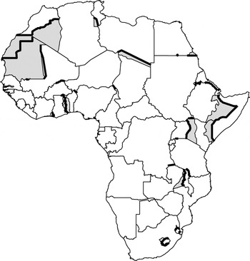
Figure 1. African territorial disputes
We focus on the contested segments. Specifically, we divide each border into one-kilometer-long segments and code whether or not each segment was contested and, if so, by which state(s) in the dyad. There is no time component to the data, so the dependent variable records whether or not the segment was ever contested in the post-independence period. However, we record the date that the claim was originally made, which will allow us to perform tests that differentiate between disputes that arose early in the life of the dyad and those that arose later. Cutting the border into one-kilometer segments is admittedly arbitrary, but doing so allows us to avoid aggregating characteristics that vary along the border even at relatively small scales. Once the data are rendered this way, we can combine these small segments to create larger ones and thereby determine whether the choice of segment length matters for any results.
One concern is that territorial claims are not scattered along a border but tend to be contiguous. The probability that any given segment is contested is highly correlated with whether or not neighboring segments are contested. We address this problem three different ways. In the main analysis, we correct for non-independence by clustering standard errors by dyad. Thus, despite the tens of thousands of observations reported in the statistical tables, the standard errors are calculated as if there are 102 observations. Second, we show that the main results remain robust because one-kilometer segments are aggregated into progressively larger border segments, a practice that reduces spatial dependence. Finally, in online Appendix C we report results obtained using a regression model that incorporates a spatial lag, thereby allowing the outcome in each segment to depend on those in its neighbors. Although this model explicitly captures the spatial dependence, implementing it requires a number of compromises so we treat these estimates as a robustness check rather than the main result.
Another limitation of focusing on contested segments is that we lose information about the depth of the territorial claim. Because we ignore whether a state claims territory close to or thousands of kilometers beyond the contested segments, we might overlook the determinants of the claim if these determinants lie deep within the neighbor's territory. For the analysis of group partitions, this does not present a serious problem, since we examine whether the segment cuts through a region inhabited by a particular group. When we look at the role of natural resources, such as oil or minerals, the presence of resources could lead to a claim deep in the neighbor's territory. To account for this, we code the segment's distance to resources within one thousand kilometers.
Descriptive Statistics
We identified twenty-nine disputed areas along twenty-seven of the 102 dyadic borders. Since several areas involve claims by both states, when rendered as claimant–target directed dyads there are thirty-seven individual disputed areas. The area of the disputed areas adds up to 2.7 million square kilometers, about 9.5 percent of Africa's total area. Of the over 76,000 kilometers of inherited borders, 13,800 kilometers or 18 percent were contested. Figure 2 depicts the variation in the area of contested regions measured as a percentage of the states' combined area (2a) and the length of the disputed segments as percentage of the total border length (2b). As the figure shows, the majority of territorial disputes in Africa involve limited areas, corresponding to less than 1 percent of the dyadic area. Only two involve demands for the outright annexation of an entire state. Border disputes also vary considerably in terms of their length. Whereas seven disputes implicate the entire border, twice as many implicate less than half.

Figure 2. Variation in dispute size, by area and length
A summary of the bivariate relations in the data appears in online Appendix B.
Data Analysis and Results
We estimate each model separately to assess its explanatory power before combining them into a model that includes variables from all three. In all regressions, the unit of observation is the one-kilometer border segment. In most cases, the estimation is done using directed dyads, meaning each segment appears in the sample twice—once with each state in the dyad as the potential claimant and the other as the potential target. In these cases, the dependent variable records, for each potential claimant and each segment, whether the country in question contested the given segment. This design is particularly useful to test arguments that hinge on characteristics of the claiming state such as its ethnic composition. In other tests, the sample uses non–directed dyads in which each segment appears only once, and the dependent variable records whether or not that segment was disputed by at least one of the states in the dyad. This design is useful to test arguments that hinge on the characteristics of the dyad or dyadic border.
Here, we estimate all regressions with a logit model; results obtained using alternative estimators that introduce a spatial lag or claimant fixed effects are reported in online Appendix C. Because there is great variation in border lengths, and thus the number of observations per dyad, all regressions include a control for the logged length of the border in kilometers.
The Ethnic Framework
Table 1 presents a series of models that explore the hypotheses from the ethnic model using directed dyadic data. The first three columns use variables derived from the GREG data set, while the second three rely on EPR. All models include an indicator for whether or not the segment partitions an ethnic group. Subsequent columns add terms with different measures of the political influence of partitioned groups in the claimant and target state.Footnote 53 Note that all of these variables are interacted with the partition indicator and so equal 0 for segments that do not partition a group. Columns (3), (5), and (6) also include controls for how fractionalized the claimant country's border was.
Table 1. Ethnic politics models

Notes: Standard errors, corrected for clustering on dyads, are reported in parentheses. *p < .10; **p < .05; ***p < .01.
As expected, columns (1) and (3) to (6) show there is no unconditional effect of partitioning on the likelihood of a dispute. Of the segments that do partition an ethnic group, however, those that partition a group that was politically powerful at the time of the dyad's independence are at a significantly higher risk of being the subject of a claim, consistent with Hypothesis 1a. This result holds for different ways of measuring the partitioned group's status: whether or not the group produced the claimant's first leader (column 2), the group's share of the claimant country's population (column 2), the interaction between these indicators (column 3), or whether the group had a dominant or monopoly position within the polity (columns 5 and 6). Since these results hinge on interaction terms, we interpret their effects and significance more fully later and in Appendix C, which formally tests the significance of the linear combinations implied by these terms. There is also consistent support for Hypothesis 1b because the probability of a claim decreases with the border fractionalization of the claimant. Finally, there is some evidence that a claim on behalf of a partitioned group is more likely to be made when the group is small or politically powerless in the target state, consistent with Hypothesis 1c. This pattern emerges clearly in the EPR data (columns 5 and 6), though not when using the GREG data (columns 2 and 3).
The different but complementary measures from the GREG and EPR data sets allow us to explore several features of these results. Figure 3 presents the substantive effects of model (3) by plotting the predicted probability of a claim on a segment as a function of whether it partitions a GREG group and, if so, whether the group produced the state's first leader and its share of the population. The effects of partitioning are clearly conditional on both group size and access to power. Relative to segments that do not partition a group, those that partition a group that produced the first leader are significantly more likely to be contested as long as the group's population exceeds about 75 percent of the country's population, a threshold that is met in half the observed cases where a first leader's group is partitioned. By contrast, the marginal effect of partitioning a group that did not produce the first leader decreases with population share, and is significantly lower than the baseline risk as long as that share exceeds 15 percent. A similar picture emerges if we condition on partition and consider the effects of group power. Relative to segments that partition a group that did not produce the first leader, the marginal effect of partitioning the first leader's group is increasing in population share and significantly different from 0 once the group exceeds one-third of the country's population. This threshold is met in about 80 percent of observations where a first leader's group is partitioned. Thus, partitioning a group can increase or decrease the risk of claim, depending on the status and size of the group.

Figure 3. The predicted effect of group partition conditional on political access and size
In addition to supporting Hypothesis 1a, these results imply that claims on behalf of the ethnic group of the first leader do not simply reflect an early-mover advantage for the group that had access to power at independence. First leaders from small groups are unlikely to make claims on behalf of partitioned kin, either because they expect opposition from larger groups or because they stand to lose by making ethnicity salient in this way. Large groups that did not produce the first leader are also unlikely to have claims made on their behalf. This suggests a disincentive to make ethnically based claims on behalf of populous groups that are not part of the leader's base and/or that leaders who come from smaller groups do not use territorial claims to cement coalitions with larger ones.
Figure 4 reports predicted probabilities for several scenarios based on the EPR data and the estimates in column (5). Relative to all other conditions, segments that partition a politically powerful group are associated with a significantly higher probability of a claim, particularly if the transborder kin are marginalized in the target. The 50 percent predicted probability of a claim in this case reflects the fact that there are seven directed dyads that have this kind of border segment, and claims occurred in four of them. By contrast, if a segment partitions a group that is in coalition or powerless, the probability of a claim is smaller or indistinguishable from that of segments that do not partition an EPR group. Finally, the probability of a claim on a partitioned group is always significantly higher if that group is powerless in the target state, holding constant its status in the claimant.

Figure 4. The predicted effect of group partition conditional on political power
Looking at the individual cases, Table 2 lists the claims that were associated with either the partitioning of a GREG group that produced the first leader in the claimant or the partitioning of an EPR group that was in control. Overall, we find that partitioning of a politically powerful GREG group—that is, one that produced the first leader and constituted a large percentage of the population—is implicated in sixteen of the thirty-seven claimant–target pairs in the data set; only eight of the disputes involve politically influential EPR groups.Footnote 54 In most of these cases, the claims encompassed large portions of the partitioned groups that lived across the border and were justified on the grounds of ethnic unification (e.g., Somalia, Togo) or reconstruction of a pre-colonial entity closely tied to the dominant ethnic identity (e.g., Morocco, Malawi, Lesotho).Footnote 55 The table also indicates (with an asterisk) the four cases in which the claim revolved around territory inhabited by a group that EPR codes as politically dominant in the claimant and powerless in the target.
Table 2. Territorial claims associated with politically powerful partitioned groups

Note: * Indicates cases in which the group was coded as powerless in the target state.
While this table emphasizes the positive cases that drive the associations in Table 1, the flip side is important as well: most segments are uncontested because they do not meet the relatively stringent conditions for a claim to be politically beneficial. Many partitioned groups were either small or lacked access to power, and many states were too ethnically fragmented to regard irredentism as appealing. Thus, the ethnic framework not only identifies areas worth contesting, it also demonstrates that the majority were not desirable in these terms. Still, considerable variation remains to be explained. To dig deeper, we turn to the alternative frameworks.
The Realist Framework
Table 3 presents three models to assess the realist framework. The first model, in column (1), tests Hypotheses 2a–c, which consider the effects of relative power and size, state capacity at the border, and the proximity of natural resources. This model fares poorly. There is evidence that the probability of a dispute increases as the claimant's share of the total dyadic area goes down; however, the insignificant coefficient on the claimant's relative power suggests that this is not necessarily the result of a mismatch between relative power and the status quo distribution, as the logic behind Hypothesis 2a suggests. There is also evidence that a claim becomes less likely as the closest mineral deposit on the target side gets farther from the border. However, the insignificant coefficient on the dummy variable indicating the presence of minerals in the target state means that minerals close to the border do not increase the risk of a dispute relative to the case in which there are no minerals at all. Finally, the effect of oil deposits near the border is statistically insignificant and in the wrong direction.
Table 3. Realist models

Notes: Standard errors, corrected for clustering on dyads, are reported in parentheses. *p < .1; **p < .05; ***p < .01.
As suggested by Hypothesis 2d, it may be that the desire for territory and minerals is strategically cloaked in the garb of ethnic politics. The models in the next two columns test this hypothesis by adding indicators to measure whether the border segment partitions an ethnic group, the percentage of the target state's territory that the partitioned group covers, and whether there are minerals in that territory.Footnote 56 Column (2) uses the GREG data, while column (3) relies on EPR. Because a group's area in the target state is correlated with its area in the claimant state, we include a control for that as well. The results belie the argument for strategic manipulation of ethnic claims. There is no evidence that states make claims to unify ethnic groups whose territorial overhang is particularly large or hosts mineral deposits. Notably, a segment is significantly more likely to be contested the larger the partitioned group's area share is in the claimant state. This suggests that claims on behalf of partitioned groups are motivated by the potential political gains at home, not deployed strategically for material gains abroad.
The findings with respect to oil and minerals suggest that these resources are not a systematic risk factor in causing disputes, contrary to recent results reported by Caselli, Morelli, and Rohner.Footnote 57 Nevertheless, there are reasons to be cautious about these findings as they pertain to mineral deposits. These data are noisy and we do not distinguish different kinds of minerals. Our variables are also silent regarding when these resources were discovered since discovery dates are incomplete. Even if such dates existed, they would have limited value since the presence of minerals may be suspected long before they are actually discovered. Thus, we have estimated the correlation between whether there was ever a dispute on a segment and whether there were ever resources nearby. One possible effect of this research design is to bias upward the estimated correlation, since a dispute might be attributed to minerals that were not discovered until later. Another possibility is that conflict depresses the likelihood of finding minerals in affected regions, which would bias the estimated correlation downward. Ultimately, existing data do not allow us to gauge the relative magnitude of these two biases.
The Institutional Framework
Table 4 presents three models to assess the institutional framework. Since most of the variables in this framework refer to features of the border, rather than features of the claimants, the main models are estimated on dyadic data. Column (1) reports the test of Hypothesis 3a. Consistent with that hypothesis, segments that follow rivers and watersheds are less likely to be contested than segments that do not. This suggests that such natural and easily identifiable and focal barriers do indeed yield a pacifying influence. This result holds in spite of the fact that, in several cases, rivers became the object of disputes (e.g., Benin–Niger, Namibia–Botswana). Straight-line segments are associated with a higher likelihood of a dispute, but this effect is not robustly significant across models.
Table 4. Institutional models

Note: Standard errors, corrected for clustering on dyads, are reported in parentheses. *p < .1; **p < .05; ***p < .01.
Column (2) adds a set of variables capturing the history of the border to assess Hypothesis 3b. The expected effects of demarcated and recently created borders do not appear, but two results stand out. First, in the relatively small number of cases (five dyads) where the border was undefined or only provisionally defined at independence, the likelihood of a dispute was very high. Indeed, only one such segment (a small portion between Mali and Niger) was not the subject of a later dispute. This result appears consistent with the importance of the territorial integrity norm, which implies that the greatest opportunity for conflict lies in places where no border was defined. However, the failure to define a border may be a product of underlying factors that also motivated the subsequent dispute, so we cannot be sure that this effect is causal.Footnote 58 Second, we find evidence that borders that were changed significantly during the colonial period experienced a higher likelihood of a dispute. This is consistent with the expectation that such changes can create multiple focal points that can be used to justify a challenge. The model in column (3) uses directed dyadic data and includes variables that distinguish between changes that created a loss for the potential claimant and those that created a loss for the potential target. As expected, the former are the most dangerous.
Overall, several variables identified by the institutional framework have a statistically significant influence on the likelihood of a claim. However, as proportional reduction in error statistics show, this model is much better at predicting which border segments will be contested (column 2) than which state will be the claimant (column 3). Indeed, while the ethnic model in Table 1, column (3), correctly predicts 36 percent of actual claims, the directed-dyadic institutional model predicts only 6 percent of actual claims. Thus, this model is most useful for identifying physical or historical features that create opportunities for a dispute—it is less useful in explaining why one state or another would want to exploit those opportunities.
Putting It All Together
We have thus shown that mechanisms associated with the ethnic politics model, as well as some associated with the institutional model, help explain variation in territorial claims. However, several different mechanisms might operate at the same time, potentially confounding one another's effects. In Tables 5a and 5b we report estimates that combine variables from all three frameworks, using the GREG and EPR codings respectively. We also use this exercise to assess the conjecture that the ethnic politics model is particularly effective in explaining disputes that arose early in the dyad's life as a result of the value of ethnically based claims in post-independence politics. To this end, we create modified dependent variables that capture whether the segment was disputed within the first decade of the border's existence (early dispute) or sometime thereafter (late dispute).Footnote 59 About two-thirds of disputes were early in this sense and they account for 80 percent of observations coded as having a claim. We estimate all models using the full, early, and late disputes. To save space, some variables that are consistently insignificant have been dropped.Footnote 60
Table 5A. Combined GREG models

Notes: Standard errors, corrected for clustering on dyads, are reported in parentheses. Constant and variable for border length included but not reported. *p < .1; **p < .05; ***p < .01.
Table 5B. Combined EPR models

Notes: Standard errors, corrected for clustering on dyads, are reported in parentheses. Constant and variable for border length included but not reported. *p < .1; ** p < .05; ***p < .01.
In the full models, the estimated effects of the ethnic variables, natural border indicators, and border history attributes retain their sign and significance from earlier tests. Oil, if anything, dampens the probability of a dispute, and there continues to be no evidence that ethnic claims are made strategically for large or mineral-rich areas. The risk associated with straight-line segments, evident in the bivariate tests and in Table 4, remains stable in the EPR model but drops dramatically when we include the GREG ethnic variables. This occurs because straight-line borders tend to surround the most homogeneous states with the least fractionalized borders (i.e., in north Africa), and their effect goes away once we include the appropriate control. It may be that the danger of straight lines derives from the nature of the populations they enclose and divide, rather than from their arbitrariness or lack of on-the-ground referents.Footnote 61
When we differentiate between early and late disputes, some new patterns emerge. Most importantly, the main effects of ethnic partitioning described earlier hold for only the early disputes. Using the GREG data, the estimates in model (2) produce similar substantive effects as those shown in Figure 3. However, the estimates in model (3) imply that partitioning a group that produced the first leader decreases the probability of a late dispute, even when the group size gets very large. A similar story emerges when we use the EPR codings: partitioning a group with access to power significantly increases the risk of an early dispute, but not a late one. Empirically, we observe only one late dispute associated with the partitioning of a large and powerful group: the claim by Swaziland against South Africa, which did not flare up until the 1980s. Thus, these kinds of claims arise early in the life of the dyad and are unlikely later. Indeed, the partitioning of an EPR group strongly diminishes the risk of a late dispute, suggesting that such claims are driven by other considerations. One possible concern is that, since our ethnic power variables were coded at the birth of the dyad, it is no surprise that they do a better job predicting disputes that arose around that time than later ones. However, an inspection of the late disputes shows that none, except the Swazi case, involved an ethnically based claim on behalf of a then-powerful group.
Robustness Checks
We conducted numerous robustness checks, including alternative indicators for group size and access to power, an alternative map of ethnic groups created by Murdock,Footnote 62 and a reconsideration of the size of the ethnic overhang necessary to consider a group as partitioned. We also used alternative estimators that introduce a spatial lag and claimant fixed effects. These analyses appear in Appendix C for reasons of space. The estimated effects of the ethnic variables remain robust to a variety of different operationalizations and estimators, particularly when explaining early disputes.
We address here the sensitivity of our results to the size of the line segments that serve as the unit of analysis. Cutting borders into one-kilometer segments allowed an accurate coding of the conditions at every location. As segments grow, salient characteristics are likely to vary along their length, requiring aggregation. For example, we can identify precisely whether any given one-kilometer segment partitions a group or not; a fifty-kilometer segment may partition a group in some places and not others or may partition more than one group. Information is lost in this process of aggregation. The methodological bet we made in this paper is that the precision obtained by disaggregation improves on the standard dyadic setup. Still, there is nothing sacrosanct about one kilometer relative to alternative lengths. Moreover, the more finely the border is sliced, the greater the spatial dependence is between each segment and its neighbors; at the other extreme, if we aggregate to the level of the entire border, spatial dependence disappears. Thus, evaluating the effects of larger aggregations can help assess the effect of spatial dependence on our inferences.
Figure 5 reports the results of a series of regressions varying the length of the segments that serve as the unit of analysis from one kilometer to one hundred and, at the furthest extreme, the entire dyadic border. For each level of aggregation, we estimate the model from Table 5, column (1). The dependent variable indicates whether the claimant state made a claim along any portion of the segment; the independent variables are the average values across the combined one-kilometer segments. The figure shows how varying segment length affects the estimated effects of two variables: whether a segment partitions a group that produced the country's first leader and whether the border follows a watershed. The marginal effect of partitioning a powerful group is robust across segments sizes, although it is measured with less precision as the aggregation level increases. This suggests that the main ethnic result is not an artifact of the decision to focus on one-kilometer segments, nor is its significance a product of arbitrary inflation of the sample size or spatial dependence. This result likely reflects the fact that the attribute in question—partitioning a large and powerful ethnic group—does not vary much across the length of a border. By contrast, the predicted effect of watershed boundaries is not statistically significant once the segment length increases above fifty kilometers. Thus, when an attribute varies across the dyadic border, the costs of aggregation can be high.

Figure 5. The effect of varying segment length
Conclusion
Significant variation exists in territorial and border disputes both across and within dyads. We exploited this variation to explore the origins of territorial and border disputes and to assess the relative value of three different frameworks about their determinants. Overall, the results suggest that the political desirability of unifying partitioned ethnic groups—while leaving others stranded—is a consistently influential predictor of claims. Ethnically homogenous states are the most likely to contest their borders and to do so on behalf of partitioned groups that are large and politically important. Ethnically heterogeneous states, on the other hand, appear more reluctant to expand their borders, and claims for unification are unlikely to be made on behalf of small or politically weaker groups. These findings should significantly strengthen scholars' confidence in the proposed causal mechanisms along these lines in the existing literature on irredentism. The institutional framework offers a second distinct powerful set of explanatory variables. The most important of these were whether a segment followed a river or a watershed, which present relatively clear and unambiguous coordinative focal principles. The coordinative effects associated with colonial history proved much less powerful, although border changes and an absence of a definitive border before independence contribute to disputes by leaving weak or multiple focal lines. By contrast, the realist framework fairs relatively poorly, although there is evidence in some models that minerals near the border can increase the risk of conflict.
Admittedly, the cross-sectional nature of our research design leaves unaddressed potentially important variation across time. Institutional changes, for example, could influence the level of inter- and intra-group competition, potentially influencing the pursuit or resolution of territorial claims. Better temporal data might also permit a clearer understanding of whether and how resource discoveries influence territorial claims.
Given our focus on Africa, the question of generalizability also arises. The method we employ here can in principle be applied globally or to other regions, and the theories are quite general. However, there is no reason why these frameworks must have the same relative explanatory power across time and space. Different regions faced different initial conditions at independence as well as different state-building imperatives. Ethnic politics also played a significant role in European territorial disputes, but not in South America, where ethnic divisions were not particularly salient. Ethnicity may not be as important in East Asia either, while the relevant divisions in the Middle East are likely to be sectarian and tribal, rather than ethnic. Our main point here is that territorial ambitions are to a large extent shaped by domestic political considerations. How those politics play out in other regions may depend on their particular historical and local conditions.
Ultimately, a fine-grained understanding of the location-specific causes of disputes is not just interesting in its own right; it also raises fundamental questions about the claims that states bring to interstate bargaining. We have seen that claims to territory are generally limited and bounded. Though these claims may be strategically understated, it seems likely that preferences for territory are similarly limited and bounded. The patterns uncovered here suggest that just as there are pieces of territory a state would like to possess, there are other pieces of territory they would rather not possess. In particular, governments seem to have little desire to obtain territories whose annexation would unify politically marginal groups or exacerbate problems of ethnic heterogeneity. If state utilities are not strictly increasing in the territory they control—an assumption implicit in bargaining models—then conflict may be avoided not because states are deterred from challenging the status quo but because they have no interest in changing it. This work suggests that much of the variation in conflict among states is rooted in domestic imperatives that determine whether and how much their territorial ambitions collide.
Supplementary Material
Supplementary material for this article is available at https://doi.org/10.1017/S0020818316000254


