


1. Introduction
Glacio-eustatic sea-level fluctuations in the Hirnantian Age (latest Ordovician) associated with development of a major icecap on the Gondwanan continent have long been recognized (Berry & Boucot, Reference Berry and Boucot1973; Brenchley & Newall, Reference Brenchley and Newall1980; Hambrey, Reference Hambrey1985; Robardet & Doré, Reference Robardet and Doré1988; Underwood et al. Reference Underwood, Crowley, Marshall and Brenchley1997) and are still being documented (e.g. Bergstrom, Saltzman & Schmitz, Reference Bergstrom, Saltzman and Schmitz2006; Fan, Peng & Melchin, Reference Fan, Peng and Melchin2009). Assuming straightforward correlation between maximum sea-level fall and maximum positive excursions of the δ13C curve there is now general agreement that two major falls in sea level during this time can be recognized globally. The first peaked in the lower-middle part of the Normalograptus extraordinarius Biozone and the second in the lower part of the N. persculptus Biozone (Underwood et al. Reference Underwood, Crowley, Marshall and Brenchley1997; Dahlqvist, Reference Dahlqvist2004; Brenchley et al. Reference Brenchley and Newall2006a ; Chen et al. Reference Chen, Rong, Fan, Zhan, Mitchell, Harper, Melchin, Peng, Finney and Wang2006; Storch, Reference Storch2006; Fan, Peng & Melchin, Reference Fan, Peng and Melchin2009). The two sea-level falls were associated with major faunal losses (e.g. Rasmussen & Harper, Reference Rasmussen and Harper2011). Climatic cooling probably began in the mid–late Katian Stage, i.e. the early part of the British Ashgill Series (Cherns & Wheeley, Reference Cherns and Wheeley2007, Reference Cherns, Wheeley and Bassett2009; Kaljo et al. Reference Kaljo, Hints, Hints, Männik, Martma and Nõlvak2011) but, unlike in the Hirnantian, any associated sea-level falls were insufficient to cause widespread erosion on shelves.
The upper Ordovician strata of the Welsh Basin have been extensively studied for over 100 years and their distribution is well known (Bassett, Reference Bassett, Williams, Strachan, Bassett, Dean, Ingham, Wright and Whittington1972). The Hirnantian Stage takes its name from Cwm Hirnant [SH 953 301] near Bala in North Wales (Bassett, Whittington & Williams, Reference Bassett, Whittington and Williams1966), although its base is not defined there (Chen et al. Reference Chen, Rong, Fan, Zhan, Mitchell, Harper, Melchin, Peng, Finney and Wang2006). Recognition of probable synglacial eustacy in the Welsh Hirnantian was initially based largely on faunal and sedimentological studies in the shelf areas of North Wales by Brenchley & Cullen (Reference Brenchley, Cullen and Bruton1984) who produced a generalized palaeogeographic map of this area for ‘lowstand’ conditions. This was later extended to the entire basin (Brenchley, Reference Brenchley, Cope, Ingham and Rawson1992; Brenchley et al. Reference Brenchley and Newall2006a ), although without direct study of the basinal areas of Central and South Wales or the shelf/slope areas of Pembrokeshire and the Garth–Llandovery area. However, complications arise when attempting to be more specific as to the identification, origin and timing of lowstands in the Hirnantian of Wales:
(1) The Welsh Basin is well known to be tectonically active for most of its history (Woodcock, Reference Woodcock1984) and sedimentological evidence of changes of relative sea level is commonly equivocal as to cause between eustacy and driving subsidence, even if not complicated by major fluctuations in sediment supply;
(2) The requirement for basinwide synchronicity of response to eustatic changes is currently impossible to prove owing to the poverty and imprecision of the biostratigraphic record, which is to date totally lacking in the early portions of the basinal sequences (Fortey et al. Reference Fortey, Harper, Ingham, Owen, Parkes, Rushton and Woodcock2000);
(3) Welsh Hirnantian lithologies are unsuitable for construction of a δ13C curve;
(4) Most of the shelf sequences have limited preservation, both down depositional dip (which might allow identification of down-stepping and upstepping system tracts) and across unconformities (which cannot be proven as not compound). Moreover the shelf–basin link is commonly across faults that were active during sedimentation (James & James, Reference James and James1969; James, Reference James1991a , Reference James1997; Davies et al. Reference Davies, Fletcher, Waters, Wilson, Woodhall and Zalasiewicz1997).
Clearly the global evidence indicates that Hirnantian glacio-eustatic fluctuations in sea level must have affected the Welsh Basin; whether or not they were the sole or even principal control on sedimentary facies is much more difficult to prove. For the reasons given above the palaeogeographic map offered in this paper attempts only a broadbrush sketch for a time band that includes both of the glacial maxima, i.e. a ‘generalized lowstand’ condition. It is, however, locally significantly different from previous maps, this resulting from the incorporation of much new palaeocurrent data and personal examination of all relevant areas of outcrop. More refined palaeogeographic maps would require widespread recognition of the persculptus/extraordinarius biozonal boundary, which is not yet available in Wales. Accordingly, I use the informal terms lower Hirnantian for that portion of the Stage preceding and including the two synglacial sea-level lowstands and upper Hirnantian for that portion of the following transgressive sequence which lies above the first appearance of N. persculptus. Clearly we may expect to find increasing, possibly compound, stratigraphic gaps between these two divisions when proceeding from basinal to shelf areas and when crossing from hangingwalls to footwalls of synsedimentary faults. If plausible evidence for two lowstands of relative sea level is widespread across the Welsh Basin then local tectonic controls are probably minor and a strong a priori case may be made for correlation of these lowstands with the two principal global lowstands caused by glacio-eustacy. This paper attempts to assess if and where such evidence exists, recognizing that a second lowstand may remove or merge with the record of the first.
2. The Welsh Basin
2.a. General description
The early Ordovician – early Devonian Welsh Basin comprises a transtensile mobile zone on the northern margin of the Avalonian micro-continent (Fig. 1), probably originating from SE-directed back-arc extension causing major bi-modal volcanism in the Arenig–Llanvirn, which was shut off in the Ashgill. During the Silurian, the basin received major turbidite influxes, shallowing into the Devonian when renewed subsidence (Soper & Woodcock, Reference Soper and Woodcock2003) accommodated thick fluvial deposits. Recent summaries of basin evolution during this period are given by Brenchley et al. (Reference Brenchley, Rushton, Howells, Cave, Brenchley and Rawson2006b ) for the Cambrian and Ordovician, Cherns et al. (Reference Cherns, Cocks, Davies, Hillier, Waters, Williams, Brenchley and Rawson2006) for the Silurian and Hillier & Williams (Reference Hillier, Williams, Brenchley and Rawson2006) for the Devonian. The basinal reconstruction (Fig. 2) is well constrained onshore save for tip points of some faults but offshore is necessarily speculative. A stretching factor of about two in Central Wales has been interpreted (James, Reference James1987a ). The basin margins are well defined NW of the Menai Strait Fault System and SE of the Welsh Borderland Fault System. In Britain the Iapetus ocean was finally consumed in the Llandovery–Wenlock when the Avalonian micro-continent docked against the major Laurentian continent. Northwest of the suture, a regime of sinistral transpression at collision (Caledonian deformation, c. 435–425 Ma) evolved to sinistral transtension during the early Devonian (Dewey & Strachan, Reference Dewey and Strachan2003). Southeast of the suture, the Welsh Basin was decoupled from the colliding margin and was not deformed by variably mild transpression until the late early Devonian Acadian deformation, c. 400–395 Ma (Woodcock & Soper, Reference Woodcock, Soper, Brenchley and Rawson2006).

Figure 1. Plate tectonic setting of the Welsh Basin (starred) bounded by the Menai Strait Fault System (MSFS) and the Welsh Borderland Fault System (WBFS). The basin lies inboard of the Iapetus Suture (IS) and largely N of the Variscan Front (VF). Data largely from Woodcock & Soper (Reference Woodcock, Soper, Brenchley and Rawson2006), who give further references. TS denotes the Tornquist Suture and SF the Scandian Front.

Figure 2. Tectonic framework of the Welsh Basin during the Ordovician–Silurian as controlled by regional sinistral transtension, with locations of major sand inputs in the late Ordovician – early Silurian. Key to major depocentres: CWB – Central Wales Basin; DT – Denbigh Trough; SB – Skomer Basin; W-UB – Woolhope-Usk basin. Key to major intra-basinal highs: BD – Berwyn Dome; HD – Harlech Dome. Key to tectonic lineaments: B – Benton Fault; BL – Bala Lineament; CWL – Central Wales Lineament; LF – Llanelidan Fault; LL – Llangranog Lineament; ML – Malvern Lineament, MSFS – Menai Strait Fault System; NL – Neath Lineament; R – Ritec Fault. The Welsh Borderland Fault System is here shown by its three principal strands: CSL – Church Stretton Lineament; PL – Pontesford Lineament and TL – Tywi Lineament. Also indicated is the position of the Variscan Front (VF), which may telescope earlier structural and sedimentary relationships. Black circles indicate poorly constrained tip points of faults.
Late Ordovician – early Silurian sedimentation in Central Wales was strongly influenced by synsedimentary half-graben development in the immediate hangingwalls of major ‘basement’ lineaments (Fig. 3). A shallow marine shelf was present immediately east of the Tywi Lineament. To the west, a NW-facing slope apron developed when lateral sediment supply rates were high relative to half-graben subsidence. However, when supply rates were relatively low the sea-bed slopes above the footwall crests were reversed, and ponded mini-basins developed above the hangingwall of the adjacent lineaments to the west, successively the Central Wales Lineament and the Llangranog Lineament. These mini-basins were sites of preferential accumulation of turbidite sandstones (James, Reference James1997) and were particularly strongly developed in the Telychian Age of the early Silurian (Davies et al. Reference Davies, Fletcher, Waters, Wilson, Woodhall and Zalasiewicz1997). The topography of the mini-basins commonly induced re-orientation of laterally derived turbidites (from the SE) into an axial (to the NE) sense of flow, even in the relatively rapid mass-flow sedimentation during the early Hirnantian. In the late Hirnantian when supply rates declined there was major ponding of the Cerrig Gwynion Grits east of the Central Wales Lineament (Smith, Reference Smith, Lomas and Joseph2004).
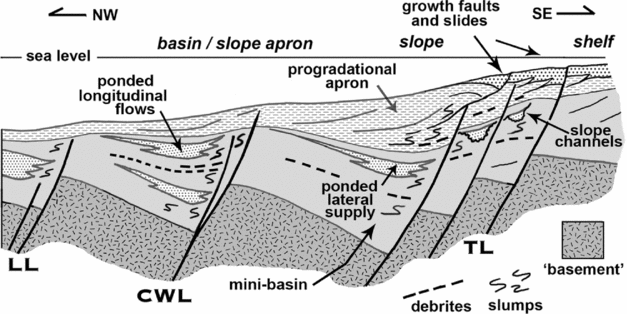
Figure 3. Tectonostratigraphic model of late Ordovician – early Silurian sedimentation in Central Wales, illustrating the interplay of sedimentation rate from the lateral margin of the basin to the east and back-tilting rate of the basin floor in half-graben controlled by activity on major lineaments. LL – Llangranog Lineament; CWL – Central Wales Lineament; TL – Tywi Lineament.
2.b. Wales within Avalonia
The Avalonian plate, an elongate micro-continent, rifted from the northern margin of the Gondwanan continent in the late Tremadoc and drifted north in the southern hemisphere for most of the Ordovician before soft-docking with the Baltic continent in the late Ordovician at a latitude estimated at about 30°S (Cocks & Fortey, Reference Cocks, Fortey and Bassett2009). This history suggests several constraints on both tectonic and climatic processes during the Hirnantian:
(1) Avalonia was by then totally removed from the proximity of Gondwana and of crustal flexures/isostatic responses affecting relative sea level that accompanied growth and decay of its icecap. This removes a major possible complication in assessing relative sea level as at latitudes where ice-grounding occurs on the shelf the principal sediment flux to the basin may be supplied during deglaciation, i.e. in a period of sea-level rise (Visser, Reference Visser1997);
(2) It was most probably outside the drift range of icebergs sourced from Gondwana: climate was presumably warm-temperate and development of icecaps on the micro-continent unlikely. This is consistent with the absence of glendonite rosettes, which need near-freezing sea-bed temperatures to develop (Selleck, Carr & Jones, Reference Selleck, Carr and Jones2009). These facts have implications for the genesis of the diamictites in Wales, which are far less likely to have originated as iceberg rainout deposits than are contemporaneous diamictites at much higher palaeolatitudes described by Robardet & Doré (Reference Robardet and Doré1988) and Alvaro & Van Vliet-Lanoe (Reference Alvaro, Van Vliet-Lanoe and Bassett2009);
(3) Although there may be far-field tectonic signatures governing sediment supply in Wales consequent to the collision with Baltica, the only candidate unconformity (the ‘Shelveian’ event) is intra-Pusgillian (Toghill, Reference Toghill1992), probably related to transpressive warping along the Welsh Borderland Fault System. It marks a cessation of anoxia in the basin, the succeeding upper Pusgillian – upper Rawtheyan (Katian) mudstones being characteristically burrow-mottled and succeeded conformably by lower Hirnantian strata. Here again a possible source of complexity in evaluating the Welsh Hirnantian seems to be at most minor. A local angular unconformity at Llandovery separating Rawtheyan strata from transgressive Hirnantian strata (Davies et al. Reference Davies, Waters, Williams, Wilson, Schofield and Zalasiewicz2009) seems likely to be fault induced;
(4) Hirnantian sediments in Wales have isotopic signatures with both Avalonian and Gondwanan components (Leng & Evans, Reference Leng and Evans1994). They include both first- and second-cycle sand-grade material (James, Reference James1971) and their petrography is fully consistent with a palaeolatitude of 30°S, which implies extremes of neither mechanical weathering at the source (cold, dry climate) nor chemical weathering (humid, tropical climate) (see van de Kamp, Reference van de Kamp2010).
3. Hirnantian environments of deposition
For simplicity I consider four environments of deposition only, which allow simple comparison with the studies of Brenchley & Cullen (Reference Brenchley, Cullen and Bruton1984) in their pioneering palaeogeographic reconstructions for the Hirnantian of North Wales. They are:
Basinal, characterized by debris flows and conformable to gently channelled turbidite sandstones conformably overlain by relatively thin burrow-mottled oxic hemipelagites and turbidite mudstones. Although individual sandstones can be compared geometrically with elements of a general fan model (e.g. James, Reference James1983; B. Cullen, unpub. Ph.D. thesis, Univ. Liverpool, 1986) no large-scale sequential vertical organization, possibly indicative of long-period fan growth, is evident either within the individual sandstones or amongst successive sandstones: a not uncommon aspect of turbidites in the Welsh Basin (Woodcock, Reference Woodcock1984, p 330). The coarse facies may collectively be termed mass-transport complexes (MTCs), several individual facies types of MTCs (cf. Pickering & Corregidor, Reference Pickering and Corregidor2005) being developed therein.
Marginal and intra-basinal slopes, characterized by slumps, rapid changes in thickness and facies and deeply channelled turbidite sandstones. Slope gradients were probably at least locally non-depositional in their higher portions (James, Reference James1991a ). If so, the likely causes could include oversteepening due to increased rates of sediment supply during the early Hirnantian regression and situation with respect to active tectonic lineaments.
Deep shelf, characterized by rarity of coarse regressive facies (which may be ‘turbiditic’/storm return flow) and by abundance of bioturbated silty lithologies shown by Brenchley & Cullen (Reference Brenchley, Cullen and Bruton1984) in North Wales to contain Hirnantia faunal associations grading into Dalmanitina assemblages as water depth increases. This environment may pass insensibly, via a ramp, into a basinal area without the intervention of a slope as defined above. Conversely, across active faults, shallow shelf environments may pass into slopes without an intervening deep shelf.
Shallow shelf, locally distinguishable as either High Accommodation or Low Accommodation sequences. High Accommodation sequences are characterized by the preservation of much or all of the coarse regressive facies of sea-level fall below finer grained transgressive facies of the subsequent rise. Only in this environment is there local preservation on the shelf of the correlative conformity to sea-level lowstands. This environment was generally submerged (subtidal) at the time of sea-level lowstands. Low Accommodation sequences are characterized by the removal of much or all of the regressive facies of sea-level fall by ravinement below commonly coarse transgressive facies of the subsequent rise. This environment was extensively subaerially exposed at the time of sea-level lowstands. Areas of high and low accommodation are not shown separately on Figures 7 and 8 where both occupy the region of ‘widespread erosion and channelling’ with a Hindella faunal association that was shown by Brenchley & Cullen (Reference Brenchley, Cullen and Bruton1984, fig. 3B) in the Berwyns. Where relative sea-level fall was appreciably smaller in the first Hirnantian glaciation than in the second, the result may be that transgressive deposits of the upper Hirnantian, i.e. the second sea-level rise, overlie regressive deposits of the first sea-level fall. This could give rise to a deceptive simplicity suggestive of only one glacial event.
My proposed modifications to the palaeogeography of Brenchley & Cullen (Reference Brenchley, Cullen and Bruton1984) essentially concern the location and facing direction of slopes; I concur in almost all respects with their environmental interpretation of sedimentary facies.
4. Timing, identification and genesis of changes in relative sea level
4.a. General remarks
Facies variation in the Welsh Hirnantian indicative of changes in relative sea level is best seen in the shelf areas, but that suggestive of glacio-eustacy is perhaps best appreciated from the basin and lower slopes where the succession is most complete. Figure 4 summarizes the dominant lithologies in the inliers of Central Wales and along the Bala and the Tywi lineaments together with biostratigraphic control (Fortey et al. Reference Fortey, Harper, Ingham, Owen, Parkes, Rushton and Woodcock2000). A major compound MTC which includes diamictites, of early Hirnantian age as here defined, is succeeded sharply by well-bedded upper Hirnantian strata of the persculptus Biozone (Cave & Hains, Reference Cave and Hains1986). The latter contain a very local coarse clastic influx related to the Caban Channel at Rhayader (Davies et al. Reference Davies, Fletcher, Waters, Wilson, Woodhall and Zalasiewicz1997) and pass upwards conformably into dominantly anoxic Rhuddanian shales and mudstones. The base of the upper Hirnantian succession, the basal Cwmere Fm, presumably reflects the cut-off of major clastic supply (and stabilization of slopes) during relative sea-level rise, probably consequent to flooding of the shelf (Woodcock et al. Reference Woodcock, Butler, Davies, Waters, Hesselbo and Parkinson1996), and is hence unlikely to correspond exactly in time with the beginning of transgression, which by definition follows a lowstand. On sedimentological grounds it is difficult to accept that the second (intra-persculptus Biozone) of the Hirnantian eustatic lowstands could lie above this contact and hence the base of the Cwmere Fm, with the first occurrence of N. persculptus, would not correspond to the base of the persculptus Biozone as indicated to do so by Fortey et al. (Reference Fortey, Harper, Ingham, Owen, Parkes, Rushton and Woodcock2000). This interpretation was set out by D. M. D. James (unpub. M.Phil. thesis, Cardiff Univ., 2003, figs III.2.2 and VII.2.3) with (a single) lowstand lying within the MTC and the maximum flooding surface of the post-glacial transgression in the anoxic portion of the dominantly oxic Mottled Mudstone Member of the Cwmere Fm. Davies et al. (Reference Davies, Waters, Williams, Wilson, Schofield and Zalasiewicz2009) considered this anoxic horizon to mark a ‘key event’ in the post-glacial transgression, arguably capable of similar interpretation. This implies that the earliest morphological form of Normalograptus recognized by Blackett et al. (Reference Blackett, Page, Zalasiewicz, Williams, Rickards and Davies2009) in Wales need not necessarily appear at the base of the persculptus Biozone. The globally widespread distribution of dark anoxic mudstones of the upper Hirnantian has been argued to signify post-glacial sea-level rise (Page et al. Reference Page, Zalasiewicz, Williams, Popov, Williams, Haywood, Gregory and Schmidt2007). In Wales, this response was clearly not over-ridden by any local tectonic influences as such sediments are basin wide.

Figure 4. Hirnantian basin and lower slope stratigraphies in Central Wales and their interpreted relationship to the two glacio-eustatic lowstands and biostratigraphic zonation. Key to lithostratigraphy: 1 – Broad Vein; 2 – Red Vein; 3 – Narrow Vein (along the Bala Lineament); 1–3 – Nant-y-moch Fm (Central Wales Inliers) and Nantmel Fm (Tywi Lineament); 4 – Garnedd-wen Fm (along the Bala Lineament), Drosgol Fm and Bryn-glas Fm (Central Wales Inliers) and Yr Allt Fm (Tywi Lineament), 5 – Mottled Mudstone Member of the Cwmere Fm; 6 – undivided Cwmere Fm, CGG denotes the Cerrig Gwynion Grits. L1 and L2 (solid stars) indicate positions of syn-glacial lowstands.
As with the base of the Cwmere Fm, the base of the MTC is also sharp and equally cannot be assigned a precise biostratigraphic age. There is no reason why it should correspond exactly with the base of the extraordinarius Biozone but on sedimentological grounds the first of the Hirnantian eustatic lowstands can hardly lie below it and must lie at or some unknown distance above it. Increased current activity and silt supply in the Narrow Vein Fm around Corris, immediately underlying the MTC, may reflect the shallowing of shelves prior to their exposure and mass-flow failure. Such shallowing globally began in the pacificus Biozone (Brenchley et al. Reference Brenchley and Newall2006a , fig. 1) associated with late Katian cooling (Cherns & Wheeley, Reference Cherns and Wheeley2007). If the Narrow Vein was deposited late in this shallowing episode it might easily lie within the basal extraordinarius Biozone (Fig. 4), although this cannot currently be proven. It has been suggested (James, Reference James1985) that triggering of the mass-flows on the basin slopes may have resulted from gas hydrate dissociation and thus be linked to sea-level fall: if so, the inception of the mass-flows may be broadly synchronous but again there is no proof. Slope failure is obviously facilitated by transport of abundant sediment to the shelf margin during decrease of water depth, and the MTC is hence interpreted as accumulating dominantly during ‘lowstand’ conditions. However, an uncritical assumption that the base of a deep-water channel is necessarily a sequence boundary is dangerous (Cronin et al. Reference Cronin, Owen, Hartley and Kneller1998) and the correlation of individual sand bodies within the MTC to specific lowstand sequence boundaries is not attempted herein.
Although it is here argued that the eustatic lowstands must lie within the MTCs this does not prove that the MTCs originate from glacio-eustatic control. MTCs in the Spanish Pyrenees that are very similar to those of Central Wales have been described by Pickering & Corregidor (Reference Pickering and Corregidor2005) and argued to result from falls in relative sea level due to tectonic control, and variation in clast sizes reflecting the extent to which coarse material reaches the shelf edge/upper slope before mass-flow failure is initiated. Where slopes are controlled by underlying active faults there is no reason why such failure should not occur during relative sea-level rise; however, the deposits may then be less likely to contain products of footwall exposure such as consolidated mega-clasts. That basin-margin faults were most probably active throughout the Hirnantian in Wales is suggested by the very limited migration of shelf/slope facies belts, which seem to have been ‘pinned’ by the faults. Also the abundance of muddy mass-flows in the basin is suggestive of slope failure independent of coarse clastic inputs; such mass-flows locally contain large ‘rafts’ (Cave & Hains, Reference Cave and Hains1986, p. 14), which may indicate footwall exposure.
4.b. The climatic significance of diamictites
During the Hirnantian, Wales and the Avalonian micro-continent lay well north of and isolated from the ice-grounding line in northern Gondwana (Sutcliffe et al. Reference Sutcliffe, Dowdswell, Whittington, Theron and Craig2000; Le Heron & Craig, Reference Le Heron and Craig2008). Fully glaciated shelves show very distinctive sedimentary facies, with debris flow diamictites and dropstone-bearing lithologies prominent, respectively, adjacent to the ice contact and outboard of it. Additionally, shear below moving ice induces soft-sediment deformation below this contact (Brodzikowski & van Loon, Reference Brodzikowski and van Loon1991; Elverhoi & Henrich, Reference Elverhoi, Henrich and Menzies1996; Sutcliffe et al. Reference Sutcliffe, Dowdswell, Whittington, Theron and Craig2000). No such facies are seen in lower Hirnantian shelf sediments in Wales, which demonstrates the absence of adjacent tidewater glaciers and sediment-bearing ice floes. Also no ice-rafted debris or dropstone penetration fabrics are seen in well-bedded sediments deposited during the late Hirnantian – early Llandovery rise in relative sea level, when any coastal ice sheets would have become destabilized by warming of their bases and liftoff from grounding. Glacial influence in deeper water sedimentary environments may also be distinctive where adjacent coasts are iced (Eyles, Reference Eyles1987; Eyles & Eyles, Reference Eyles and Eyles1989) but, as this was not the case in Wales, the diamictites of the early Hirnantian are likely to have an origin as mass-flows. Diamictites are best developed in the Central Wales Inliers where a mass-flow origin was argued by James (Reference James1983). They locally contain armoured mud balls consistent with such origin (Fig. 14a), and no dropstones (Bennett et al. Reference Bennett, Doyle, Mather and Woodfin1994) are seen in spatially associated bedded sediments.
4.c. Sequence stratigraphy
Identification of the lowstands should be consistent with a sequence stratigraphic interpretation of the vertical succession of sedimentary facies. As this is commonly not unequivocal I have tried to avoid routinely casting the sedimentological subdivisions into the terminology of sequence stratigraphy, which is illustrated in Figure 5. Sequence stratigraphy provides a rational framework for the interpretation of changes in water depth in terms of changes in relative sea level but great care is needed in its application to tectonically active basins such as that in Wales (Woodcock et al. Reference Woodcock, Butler, Davies, Waters, Hesselbo and Parkinson1996) and clearly such attempts should avoid data collected adjacent to active faults. The forcing mechanism might equally be tectonic, i.e. a reconfiguration of slopes and/or catchment areas and change in the severity of erosion in the hinterland. The original concept of coastal onlap/offlap as a reflection of an assumed sinusoidally varying eustatic sea-level fluctuation (see van Wagoner et al. Reference van Wagoner, Posamentier, Mitchum, Vail, Sarg, Loutit, Hardenbol, Wilgus, Hastings, Posamentier, Wagoner, Ross and Kendall1988) neglects not only fluctuation in sediment supply and tectonic driving subsidence but also the flexural response of the lithosphere to change in water load, which is particularly evident in ice ages (Gray, Reference Gray and Menzies1996). Other complications with the sequence stratigraphic model are increasingly recognized, even during constant rate of eustatic sea-level change. They include non-equilibrium (autogenic) causes whereby a sedimentary system internally adjusts the depositional/erosional geometry of its major internal supply routes to a more stable configuration (Muto, Steel & Swenson, Reference Muto, Steel and Swenson2007) and the effects of mixed-energy processes along depositional strike such as the 3D nature of the degree of bypass/dispersion (Karner & Driscoll, Reference Karner and Driscoll1997; Yoshida, Steel & Dalrymple, Reference Yoshida, Steel and Dalrymple2007). Despite these qualifications, if short-period sea-level fluctuations as may occur in glacial/inter-glacial periods were appreciably shorter than the time scales for non-equilibrium response to steady forcing of the depositional systems in Wales, then the stratigraphic record may approximate the response to such non-steady (allogenic) forcing and tentative interpretation of facies using sequence stratigraphy may be justified.

Figure 5. Summary of sequence stratigraphic terminology (for shelf sequences) used in this paper, incorporating the four segments of the relative sea-level curve and the accretionary/non-accretionary scenarios of Helland-Hansen & Gjelberg (Reference Helland-Hansen and Gjelberg1994).
5. Hirnantian facies distribution in Wales
Figure 6 shows the extent of preserved Katian and Hirnantian strata in Wales based largely on Williams et al. (Reference Williams, Strachan, Bassett, Dean, Ingham, Wright and Whittington1972) and the British Geological Survey (1994) together with localities mentioned below. Seven areas are distinguished for discussion of Hirnantian facies distribution which is, where useful, supplemented by data from immediately underlying Katian strata: within each there is first a summary of previous work, then the view argued in this paper, based on new facies descriptions and palaeocurrent data. As far as practicable, local stratigraphic names are avoided. Figure 7 shows the early Hirnantian palaeogeography as now interpreted. This figure includes key locality data simplified from Figure 6 and numerically identifies those sand bodies that are discussed in the text. Palaeocurrent data are summarized in Figure 8.

Figure 6. Location map for Ashgill outcrops in Wales with positions of major tectonic lineaments shown in Figures 2 and 3. Major areas discussed in text are: BD – Berwyn Dome; BL – Bala Lineament; CWI – Central Wales Inliers; DT – Denbigh Trough; TL – Tywi Lineament; SLL – Southern Llangranog Lineament; VF – Variscan Front. Key to lineaments (other than the Bala and Tywi lineaments): CVFS – Conwy Valley Fault System; CWL – Central Wales Lineament; DML – Dinas Mawddwy Lineament; LF – Llanelidan Fault; LL – Llangranog Lineament; MSFS – Menai Straits Fault System; PL – Pontesford Lineament; SVFS – Severn Valley Fault System. Key to settlements: AC – Abbey Cwmhir; B – Bala; Br – Brechfa; ByC – Betws-y-Coed; C – Corris; CE – Conwil Elvet; CM – Cotland Mill; Cn – Corwen; Cr – Criccieth; Cw – Conway; Cyd – Cerrigydrudion; DM – Dinas Mawddwy; G – Garth; GC – Glyn Ceiriog; Hd – Holyhead; Hf – Haverfordwest; Lg – Llangranog; Ls – Llansawel; Ly – Llandovery; M – Meifod; Md – Meidrim; PE – Pont Erwyd; R – Rhayader; RW – Robeston Wathen; T – Tywyn; W – Welshpool. Key to inliers and localities: AP – Afon Pumrhyd; ByC – Blaen-y-Cwm; ByG – Bwlch-y-Groes; CNH – Coed Nant Hir; CyB – Cyrn-y-Brain; Dg – Disgwylfa; F/FF – Forge/Foel Fawr; FF – Freni Fawr; G/G – Gorllwyn/Gamriw; H – Cwm Hirnant; L – Llyfnant; LB – Llyn Barfog; LH – Liberty Hall; MC – Mynydd Cricor; NA – Nant Aclas; O – Ogofau; P – Plynlimon; PyD – Pen-y-Ddinas; PyG – Pen-y-Garn; Pyr – Porthyrhyd; Rg – Rhanneg; Rm – Rhandirmwyn; Rn – Rhiwnant; V – Van; Yf – Ystradffin; YI – Ysbyty Ifan. Also shown are the boundaries of the relevant 100 kilometre square divisions (SH etc.) of the British National Grid.


6. The Denbigh Trough
6.a. Previous work
Stratigraphic data for the Ashgill are given by Elles (Reference Elles1909) at Conway and by D. A. B. Davies (Reference Davies1936), Stevenson (Reference Stevenson1971) and Cave, Evans & Campbell (Reference Cave, Cope, Ingham and Rawson1992) towards Cerrigydrudion. The Katian/Hirnantian boundary is nowhere precisely located. Considerable differences of published mapping exist, e.g. British Geological Survey (1994), Howells, Reedman & Campbell (Reference Howells, Reedman and Campbell1991) and Cave, Evans & Campbell (Reference Cave, Evans and Campbell1992). Conclusive demonstration of preferred accommodation space is thus not currently possible. North of the footwall of the Bala Lineament a gentle trough is suggested by thickness distribution in upper Katian strata, rising again to a slope-base immediately SE of the Menai Strait Fault System. The deepest part of the trough lies in the hangingwall of a synsedimentary fault at Ysbyty Ifan (D. M. D. James, unpub. M.Phil thesis, Cardiff Univ., 2003) if, as assumed, the Ashgill downthrow is to the SE as in the Caradoc.
At Conway, the lower Hirnantian deep-water Conway Castle Grits (sand body 1) were shown by B. Cullen (unpub. Ph.D. thesis, Univ. Liverpool, 1986) to contain a variety of turbidite facies suggestive of a classical fan model with suprafan lobes and an inner fan channel in the north and non-channelized mid-outer fan lobes in the south. Palaeocurrents indicate flow towards the ESE (James & James, Reference James and James1969). The Grits are overlain by upper Hirnantian mudstones (Warren et al. Reference Warren, Price, Nutt and Smith1984). Between Dolgarrog and the Conway area the Ashgill is of mudstone facies and thickens southwards with an increase in silty intercalations, suggestive of deepening in this direction. No coarse deposits suggestive of Hirnantian sea-level fall are present hereabouts but the narrow outcrop sub-parallel to the depositional dip may not sample such deposits.
The SW limit of the Denbigh Trough in the Hirnantian is not known and no strata of this age have yet been proven in Snowdonia and the Lleyn Peninsula, although it is possible that the unfossiliferous siltstones in the topmost 18 m of the Ashgill in the Dwyfor section near Criccieth (B. Roberts, Reference Roberts1967) could be of this age. There is a considerable stratigraphic gap here as the ‘abruptly’ succeeding Llandovery may be no older than mid-Aeronian (B. Roberts, Reference Roberts1967). This latter situation might hint at Hirnantian non-deposition above storm wave base; however, no evidence suggestive of shoaling-up is reported and the gap may equally probably result from slump-scar excision. No Hirnantian strata are known on Anglesey, but Brenchley & Cullen (Reference Brenchley, Cullen and Bruton1984, fig. 3) showed a mixed carbonate-clastic shelf SE of a shoreline near Holyhead, this interpretation based on the petrography of the Conway Castle Grits.
6.b. This paper
I regard the typically ‘platey’ parallel-bedded fine sandstones around Cerrigydrudion, as exposed in the small quarries around [SH 962 492], as being of distal shoreface affinity and hence indicative of shallowing hereabouts in the early Hirnantian, but have found no palaeogeographically useful directional sedimentary structures therein.
The ‘flaggy’ beds with ‘cross-bedding’ recorded by D. A. B. Davies (Reference Davies1936) from the uppermost portion of the Grinllwm Slates just north of Betws-y-Coed (sand body 2) are turbidites with abundant ripple lamination. They comprise 2–7 cm units of silty sandstone intercalated with 3–10 cm silty mudstones of which many are visibly graded. Excellent exposures around [SH 796 603] yield a transport direction towards the WNW. It is tempting to speculate that this sandy package was supplied during a lowstand; more certainly its location provides an important constraint on the contemporaneous position of the bathymetric axis of the Denbigh Trough. As with the Conway Castle Grits and the succession at Dolgarrog, it is difficult to argue for two lowstands, although again the narrow outcrop sub-parallel to the depositional dip may not sample such deposits. The lithology of the slates suggests an origin as pelitic mass-flows but no diamictites are known therein. It now seems that a Denbigh Trough sensu Cummins (Reference Cummins and Wood1969) was beginning to develop in the late Katian and was well expressed in the Hirnantian. If so, lack of coarse detritus from the former volcanic areas of North Wales to the SW suggests bevelling in the Katian: further bevelling during the early Hirnantian lowstands is also plausible. This could have resulted in local palimpsest shallow shoals of pebbly lag deposits available for resedimentation SE across the Bala Lineament. The thin (up to 8 m) conglomeratic channel deposits of sand body 5 near Tywyn (James, Reference James1973), which have not yielded palaeocurrent data, may have such an origin.
The Ashgill inliers of Mynydd Cricor and Cyrn-y-Brain (Hiller, Reference Hiller1981) lie in the immediate footwall of the Llanelidan Fault, which is plausibly an important structural element in the southern margin of the Denbigh Trough. Lowstand conditions are arguably recorded by the sandstones of the Cricor Fm (the distal portion of sand body 3), which succeed the broadly coarsening-upwards mudstones/siltstones of the (?largely) Katian Cyrn-y-Brain Fm with general conformity, albeit that the coarsest sandstones locally show mildly channelled bases. In contrast to the thicker developments of the laterally equivalent Glyn Fm in the North Berwyns (Hiller, Reference Hiller1981), the sandstones seldom exceed 15 m thickness in the two inliers and are commonly much less (Wills & Smith, Reference Wills and Smith1922). Palaeocurrent indications from cross-bedding are similarly oriented in both inliers and pooled data display two modes with transport to both the NW and SE, suggestive of tidal influence and very similar to data from the North Berwyns (see following Sections).
7. The Bala Lineament
7.a. Previous work
Between Tywyn and Corris the upper Hirnantian is represented in large part by the Garnedd-wen Fm (Pugh, Reference Pugh1923; Jehu, Reference Jehu1926; James, Reference James1972, Reference James1973; M. J. Leng, unpub. Ph.D. thesis, Univ. College of Wales, Aberystwyth, 1990; Pratt, Woodhall & Howells, Reference Pratt, Woodhall and Howells1995). It contains diamictites, pebbly mudstones, and both ‘proximal’ and ‘distal’ turbidites of similar facies to those at Plynlimon, albeit with dissimilar internal stratigraphy. Much of the formation is non-bedded to a degree that makes precise calculation of thickness difficult. Between Tywyn and Bala the Rawtheyan (Katian) stratigraphy affords control on relative and, in some degree, absolute variations of water depth (Price & Magor, Reference Price and Magor1984; James, Reference James1985). Much of the basinal Garnedd-wen Fm accumulated under depths of many hundreds of metres, at pressures within the stability field of gas hydrates for cool (synglacial) sea water (Henriet & Meinert, Reference Henriet and Meinert1998). Melting of such hydrates during sea-level fall and/or post-glacial rise in water temperature could have contributed to the widespread early Hirnantian slumping.
Northeast of Aberllefenni, c. 4 km NE of Corris, the Garnedd-wen Fm loses major developments of coarse lithologies and slumps and thins rapidly to c. 150–200 m, almost exclusively consisting of mudstone. A local development of ‘distal’ turbidites (sand body 4) near Dinas Mawddwy displays transport to the SSW, influenced by fault topography in the hangingwall of a SE-facing slope along the Bala Lineament (James, Reference James1991b ). The higher levels of the formation are less silty than the lower and were mapped separately by Pugh (Reference Pugh1928, Reference Pugh1929). James (Reference James1985) suggested that this contact might represent the correlative conformity to a lowstand (here interpreted as lowstand 2). The two divisions merge into the relatively fossiliferous deep-shelf Foel-y-Ddinas Fm (sensu Bassett, Whittington & Williams, Reference Bassett, Whittington and Williams1966) at Bala (Pugh, Reference Pugh1929). The junction between the Garnedd-wen Fm and the laterally equivalent portion of the Foel-y-Ddinas Fm with the Moelfryn Fm is not obviously erosive but interpretable as locally non-depositional (James, Reference James1991b ). If so it could represent a first pulse of sea-level lowering around the Rawtheyan–Hirnantian boundary (cf. Rong & Harper, Reference Rong and Harper1999) but within biostratigraphic precision might equally represent the first Hirnantian lowstand. The junction between the Drosgol Fm and the Nant-y-Moch Fm at Plynlimon can be interpreted similarly. In shallower water, at Bala, Williams et al. (Reference Williams, Strachan, Bassett, Dean, Ingham, Wright and Whittington1972) placed a local unconformity, possibly representing a lowstand and now considered to be compound (Fig. 11), at the contact of the Foel-y-Ddinas Fm with the underlying (Katian) Moelfryn Fm; Hiller (Reference Hiller1981, fig. 7) does likewise. This seems to be correct in the footwall of the Bala Fault but conflicts with the position of the unconformity in the hangingwall shown by Bassett, Whittington & Williams (Reference Bassett, Whittington and Williams1966) at the base of the Hirnant Limestone, which may represent the second lowstand as suggested by its chitinozoan fauna (Vandenbrouke et al. Reference Vandenbrouke, Hennissen, Zalasiewicz and Verniers2008). Unfortunately, the sedimentology of most of the Foel-y-Ddinas Fm is rather uniform, and it is not currently feasible to allocate its lower part unequivocally to either a transgressive or regressive event. The Hirnant Limestone at the type section quarry [SH 9510 2963] is ooidal (Fulcher, Reference Fulcher1892), indicative of a low rate of accumulation in shallow well-oxygenated water with episodic storm reworking. Such conditions commonly occur near the far point of lowstand regression, ooids forming immediately above the sequence boundary during initial sea-level rise (cf. Taylor et al. Reference Taylor, Simo, Yocum and Leckie2002). The laterally equivalent Calettwr Quartzite is here interpreted as a distal deeper water equivalent of sand body 3. Its massive and planar-bedded facies resemble facies within the much thicker Glyn Fm (Hiller, Reference Hiller1981) of the northwestern Berwyns, although, in contrast, no large-scale cross-bedding appears to be present. The relative paucity of bioturbation in the Foel-y-Ddinas Fm compared with that in the probably time-equivalent portion of the Nant Aclas Fm in the western Berwyns may support a somewhat deeper site of deposition. Palaeocurrent data from the quartzite is lacking but ripple lamination in closely underlying siltstones indicates flow broadly towards the south.
Brenchley & Cullen (Reference Brenchley, Cullen and Bruton1984) showed a W-facing palaeoslope between Bala and Dinas Mawddwy without any topographic expression of the Bala Lineament. By contrast, the rapid thickness variations in the Moelfryn Fm and the Foel-y-Ddinas Fm, together with increased depth of pre-Ashgill erosion NW of the Bala Fault, were interpreted by Bassett, Whittington & Williams (Reference Bassett, Whittington and Williams1966) as indicative of synsedimentary fault control with downthrow to the SE (see also Fitches & Campbell, Reference Fitches and Campbell1987). James & James (Reference James and James1969) suggested that SE downthrow on the lineament in the Corris-Dinas Mawddwy country controlled the facies change from the muddy slope deposits of the (Katian) Broad Vein Fm into the basinal turbidites of the Nant-y-Môch Fm at Plynlimon. The Katian–Hirnantian evolution of movement on the Bala Fault can be interpreted as occurring in two phases, first of flexure then of fault breakthrough to the depositional surface (cf. Gawthorpe et al. Reference Gawthorpe, Sharp, Underhill and Gupta1997) (see Fig. 10a, b). Channelled turbidites of sand body 6, up to 30 m thick in the Garnedd-wen Fm near Corris (e.g. [SH 718 063]) show flow to the NW (James, Reference James1972) requiring rapid re-orientation of flow to the SW in now-eroded stratigraphy in the vicinity of the Bala Lineament, if this was then active with downthrow to the SE. Such geometry could have been produced by rapid hangingwall subsidence locally reversing the sea-floor slope.
7.b. This paper
The Tywyn-Bala transect displays Hirnantian strata at variable distance SE of the Bala Lineament, which is considered to have controlled the location of the slope break. Southwest of the intersection of this structure with the Llangranog Lineament near Corris, environments are lower slope/basinal but to the NE are upper slope/outer shelf (Bassett, Whittington & Williams, Reference Bassett, Whittington and Williams1966; Brenchley & Cullen, Reference Brenchley, Cullen and Bruton1984; James, Reference James1985, Reference James1991b ).
Towards Dinas Mawddwy, large ripples with 5–20 cm amplitude are commonly developed within, and especially towards the top of, the dominantly hemipelagic Narrow Vein, i.e. immediately below the Garnedd-wen Fm (Fig. 9a, b). They occur in varve-like millimetre-scale laminated mudstone/siltstone with a transport direction between the NE and SE and were probably formed by currents flowing predominantly along slope towards the NE, consistent with derivation from the NW and subsequent Coriolis turning (Fig. 9c). The ripples may also indicate a change in bottom-current regime and associated basinal circulation due directly to climate change, i.e. the onset of cooling (cf. Ruddiman & Bowles, Reference Ruddiman and Bowles1976), probably in the late Rawtheyan – early Hirnantian but not precisely constrained.

Figure 9. (a, b) Ripples in muddy siltstones of the Narrow Vein Formation, Hendre Meredydd quarry, [SH 822 116]. (c) Interpretation of palaeocurrent data for the Narrow Vein Formation in terms of Coriolis stripping of dilute turbid flows across a SE-facing slope controlled by an active Bala Lineament (BL). Flow mechanics based largely on Jiang & Garwood (Reference Jiang and Garwood1996).
Slumps and thin turbidites in the Broad Vein Fm at Tap Nyth-yr-eryr [SH 905 217] show SE-directed transport. At Coed Nant Hir, a slump complex exposed in the Garnedd-wen Fm around [SH 814 111] has an internal structure interpretable as a leading edge imbricate thrust fan facing SE (Fig. 10c). Channelled distal shelf/upper slope turbidites of sand body 4 in the Garnedd-wen Fm show SSW-directed transport at Bwlch-y-Groes and a similar facies also feeding sand body 4 is exposed in Afon Pumryd [SH 891 196]. Here the Lower Garnedd-wen Beds of Pugh (Reference Pugh1929) contain numerous ‘distal’ turbidites generally 1–6 cm thick, rarely up to 12 cm. Transport direction from well-preserved ripple lamination is southeasterly. A few 1–3 cm thick similar turbidites in the lower part of the Upper Garnedd-wen Beds display similar palaeocurrents. Rare palaeocurrent data from proximal turbidite sandstones of the basal Garnedd-wen Fm near Tywyn (sand body 5) indicates flow to the SE/ESE and from sandstones near the top of the Formation (James, Reference James1973) largely to the SW with a minor mode to the NE, possibly indicative of shingling overlap of sandy micro-fans deposited near now-eroded active channels on a SE-facing slope.

Figure 10. (a, b) Cartoons of postulated tip line evolution above the Bala Lineament resulting in growth faulting during the Hirnantian. Katian flexure above the tip (a) was followed by breakthrough to surface with accompanying reversal of palaeoslope into the fault hangingwall (b) resulting in re-orientation of turbidite flows in sand body 6. (c) Map and section of the Coed Nant Hir slump in the Garnedd-wen Formation (stippled). Key to slate quarries in the underlying Narrow Vein Formation: C – Cymerau; Hd – Hendre-ddu; HM – Hendre Meredydd; R – Ratgoed. S indicates the best exposure of the slump around [SH 8137 1111]. (d) Cartoon cross-section along the axis of the Brogan Anticline in the Wenlock illustrating a non-depositional slope origin for the Wenlock/Ashgill contact. Both the Llandovery and Wenlock are of basinal facies to the west of the slope and of shelf facies to its east. Note development of a Hirnantian transgressive sandstone (the Graig Wen Sandstone) in the Meifod area removing most of the earlier Hirnantian regressive sandstones locally still preserved in channels around the Mathrafal–Meifod area.
If the Bala Lineament was active in the Hirnantian with downthrow to the SE (Bassett, Whittington & Williams, Reference Bassett, Whittington and Williams1966), the position of the two lowstands would vary across it (Fig. 11). On the footwall only very thin Hirnantian strata are preserved, probably overlying a transgressive surface of erosion (TSE) which has removed all traces of either lowstand. On the hangingwall I interpret the local non-sequences at the base of the Foel-y-Ddinas Fm as the lowstand surface of erosion (LSE) of lowstand 1. The Hirnant Limestone and Calettwr Quartzite are here considered to lie in channels cut in the shelf during lowstand 2, their sharp tops possibly reflecting the end of a lowstand systems tract (LST) and start of a subsequent TSE. In the Berwyns where accommodation space was lower than in the hangingwall depocentre at Bala, the trace of lowstand 1 may have been completely removed during lowstand 2 at the base of the Glyn Fm.

Figure 11. A correlation in cartoon form of upper Ordovician – lower Silurian strata from Bala to Welshpool. Chronostratigraphic units bounded by unconformities and correlative conformities (solid lines): A – Aeronian; R – Rhuddanian; 8 – Hirnantian; 7–5 – Rawtheyan; 4–2 – Cautleyan; W – Woolstonian; L – Longvillian; S – Soudleyan. Onnian deposits of the Nod Glas (Blaen-y-Cwm Shale, Pen-y-Garnedd Shale) shown solid; horizons above the Nod Glas and below Cautleyan zone 2 are undifferentiated Pusgillian to Cautleyan zone 1 and the possibility that the base Ashgill unconformity may descend into this interval is not represented. Sandstones: a – Cefn Formation; b – Powis Castle conglomerate; c – Garn Wen sandstone (Hirnantian); d – Glyn Formation. Limestones: e – Rhiwlas; f – Dolhir; g – Cymerig; h – Pen-y-Garnedd. Bold labelling (1 and 2) of the unconformities corresponds with erosion surfaces considered to be associated with the two glacio-eustatic lowstands. Length of section c. 60 km. Vertical scale for the different units is distorted for clarity but lateral thickness changes in individual major units are approximately correct relative to each other.
8. The Berwyn Dome
8.a. Previous work
The Ashgill succession in the Corwen and Glyn Ceiriog areas of the northern Berwyns has been described by Hiller (Reference Hiller1981). It is similar to the thinner succession in the adjacent inliers of Mynydd Cricor and Cyrn-y-Brain with a regressive passage from open shelf conditions in the Rawtheyan to shallow sub-littoral conditions in the Hirnantian. The rapid transgressive passage of the Hirnantian into the deepening shelf conditions of the Llandovery appears conformable, i.e. the correlative conformity of at least one Hirnantian lowstand lies within the Glyn Fm and its equivalents, possibly at the level of widespread subtidal channelling, locally c. 50 m deep, that is thought to have been filled during subsequent transgression (B. Cullen, unpub. Ph.D. thesis, Liverpool Univ., 1986). The NW-directed palaeocurrents in the Glyn Fm at Corwen probably represent ebb flow in such channels. The widespread occurrence of sharp-based coarse lithologies in the northern Berwyns may indicate that some are not channel fills but rather down-stepping erosive shorefaces of a forced regressive systems tract (FRST). In either case, they could lie close to a sea-level lowstand. The detailed work of Brenchley et al. (Reference Brenchley and Newall2006a ) on the Meifod channel allows the possibility that the ‘lowstand’ is locally complex and multiple, and that the Glyn Fm might contain both of the two synglacial lowstands (see Fig. 11).
There is scarcely any published work on the Nant Aclas Fm of the western Berwyns which equates to all or part of the Moelfryn/Foel-y-Ddinas succession at Bala and is c. 550 m thick (Brenchley, Reference Brenchley, Woodcock and Bassett1993). Its age is not known in detail but is thought to include Hirnantian and Rawtheyan strata. The succession is c. 370 m thick at the near vertical Blaen-y-Cwm section (King, Reference King1923). Here the 4–5 m thick transgressive Graig Wen Sandstone rests on a ravinement surface cutting out at least 14 m of underlying Nant Aclas Siltstone present c. 4 km to the SW (King, Reference King1923, p. 498). Fossils immediately below this unconformity appear to be Rawtheyan, the lowstand erosion surface not being preserved. In Nant Aclas no unconformity within the Nant Aclas Siltstone is yet known, although exposure is incomplete and it is also possible that any such surface lies beneath the base-Telychian unconformity further west.
8.b. This paper
Southeast and ESE of Corwen, on the hills around Liberty Hall [SJ 089 412] and Cerrig Coediog [SJ 117 388] the sandstones of the Glyn Fm (sand body 3) contain superbly exposed large-scale, locally oversteepened, trough and planar cross-bedding with reactivation surfaces but lacking clay drapes on the foresets (Fig. 13f). Channelling is abundant (Fig. 13g). I interpret the palaeocurrent data (Fig. 8) as indicating tidal ebb flow towards the NW and flood flow towards the SE from these two localities, which add significantly to those mentioned by B. Cullen (unpub. Ph.D. thesis, Liverpool Univ., 1986).
At Nant Aclas the sandstones are not discrete coarse–medium-grained beds reminiscent of the Glyn Fm but merely local thickening and coarsening of 2–10 cm fine siltstones into 25–80 cm very fine sandstones. In general, the siltstones are monotonously parallel bedded and without ripples or any directional structures. An inner-midshelf subtidal environment is plausible with silt introduced from either storms or glacial (pluvial?) floods. There is little sign of shoreface proximity. The exposures around Rhanneg [SJ 004 335] show very different facies, although exact age equivalence is unproven. Here, a broadly coarsening/thickening-upward succession is typified by unidirectional, commonly loaded, ripples in 1–5 cm siltstones intercalated within silty mudstones up to 30 cm thick. Around [SJ 003 337] fine–medium-grained sandstones with cross-bedding and possible hummocky cross-stratification appear to lie in minor channels 3–6 m thick. The rippled horizons are locally flaser-bedded. Transport was clearly to the WSW in both sands and silts. A more energetic environment than to the south is indicated, possibly not only nearer shore but the site of a long-lived rip-current depression in the lower shoreface.
Southwest of Meifod (King, Reference King1928) the Rhuddanian shallow shelf strata and the Aeronian–Telychian deep-shelf strata are missing and the Ashgill, presumed Katian, is onlapped by the deep-water Wenlock Denbigh Grits (see Fig. 10d). The onlap of the turbidites is clearly visible in the topography of the face of Disgwylfa Hill [SJ 037 075]. The slope may be estimated as c. 5°, facing broadly W or WSW, approximately normal to northerly directed flow in the turbidites. Synsedimentary sliding in the Afon Banwy section c. 7 km to the NE (Loydell & Cave, Reference Loydell and Cave1996) may indicate that the updip extent of the slope was extensive. I consider the non-sequence to be inherited from an oversteepened non-depositional slope of Hirnantian age as there is no evidence for fault control.
At Meifod, Hirnantian strata are proven in the Graig Wen Sandstone (Brenchley, Reference Brenchley, Woodcock and Bassett1993). I interpret the basal erosion and possibly the basal fill of the steep-sided channels here (King, Reference King1928, fig. 1) as associated with channelling during lowstand regression. The immediately overlying sandstone extending away from the rugose channels is thin, 3–5 m, and laterally extensive with sheet like geometry. I concur with Cave (Reference Cave, Cope, Ingham and Rawson1992) that this portion of the sandstone is transgressive and locally overlies a ravinement surface which merges with that of the ‘Llandovery transgression’ of the Welsh Borderland (Zeigler, Cocks & McKerrow, Reference Zeigler, Cocks and McKerrow1968). It locally overlies the monotonous mudstones of the Dolhir Fm, here of Rawtheyan age (Hiller, Reference Hiller1981), and on a glacio-eustatic interpretation must represent the transgression after lowstand 2, the regressive deposits of which have been eroded by the ravinement together with all deposits of lowstand 1. The Allt Goch Sandstone of the Llanfyllin area is time-equivalent to the Graig Wen Sandstone and may be similarly interpreted. Neither B. Cullen (unpub. Ph.D. thesis, Liverpool Univ., 1986) nor I have found useful palaeocurrent data in these areas.
Correlation with the sequence at Bala is not unequivocal but Figure 11 offers a possible model for future testing. It is noteworthy that early Hirnantian fall and late Hirnantian rise in relative sea level is evidenced in both the footwall and hangingwall of the Bala Lineament and was thus faster than any tectonic uplift/subsidence therein.
9. The Central Wales Inliers
9.a. Previous work
The early classic stratigraphic work is that of Jones (Reference Jones1909), Jones & Pugh (Reference James1935) and W. D. V. Jones (Reference Jones1945), later revised in detail by Cave & Hains (Reference Cave and Hains1986). The sedimentology and tectonic setting of the lower Hirnantian is described by James (Reference James1972, Reference James1983, Reference James1987b ) and C. R. Tremlett (unpub. Ph.D. thesis, Univ. College Wales, Aberystwyth, 1982). Sedimentation was influenced by activity on the Llangranog and the Central Wales lineaments and the degree of ponding/flow diversion induced makes for considerable uncertainty in correlation between the three principal inliers.
In the Plynlimon and Van inliers, the lower Hirnantian is presumed to be largely represented somewhere within the two faunally barren and locally coarse intervals of the Drosgol Fm and the overlying Bryn-glas Fm, together c 500 m thick. Slump folds are uncommon but debris flow deposits abound: of particular interest is the interpretation by Cave & Hains (Reference Cave and Hains1986, p.6) that the silty mudstones comprising almost the entire Bryn-glas Fm and much of the Drosgol Fm represent fluid mass-flows of mud, silt and disrupted, streaked-out sand layers. Earlier work had recognized local fabrics suggestive of mass-flow but did not sufficiently consider that this process might generate widespread totally homogenized deposits. At Van, at least one coherent sandstone body in the Bryn-glas Fm appears to be a large raft and numerous large isolated balls of sandstone within mudstones of the Drosgol Fm are well exposed along the wave-washed shores of Llyn Clywedog (e.g. [SN 921 883]). Palaeocurrents in the turbidites of sand bodies 6 and 7 are dominantly from the S at Plynlimon and from both the S and E in the two principal inliers at Van (James, Reference James1983, fig. 6). The coarser ‘proximal’ turbidites are gently channelled rather than forming aggradational fans. The stratigraphy includes a variety of turbidites (e.g. Fig. 14b) and diamictites (Fig. 14g), with many ‘disturbed’ horizons indicative of either foundering or slumping or both. Channel location, palaeocurrent data and thickness variation in sand body 6 at Llyfnant have been held to suggest a local WNW-facing slope (James, Reference James1972, Reference James1987) but this interpretation, and the control of sedimentation by deep-seated faulting, was not accepted by Cave & Hains (Reference Cave and Hains1986), despite close proximity of the Llyfnant area to their Glandyfi Lineament. Leng & Cave (Reference Leng, Cave, Woodcock and Bassett1993, fig. 2) allocated the Drosgol/Bryn-glas succession to the Rawtheyan and hence require the Mottled Mudstone Member of the Cwmere Fm to contain the lower Hirnantian synglacial successions. This seems sedimentologically implausible.
9.b. This paper
The presumably complete, faunally barren, lower Hirnantian of this area should contain the correlative conformities of both synglacial lowstands. Although framing their analysis in terms of only one, admittedly possibly complex, lowstand, Davies et al. (Reference Davies, Waters, Williams, Wilson, Schofield and Zalasiewicz2009) took the same view but correlated this with the major sand body mapped by the British Geological Survey as the Pencerrigtewion Member separating the Drosgol Fm and the Bryn-glas Fm. I prefer to be less specific because what has been mapped as this unit is arguably of somewhat different age (and petrography) in the different inliers (James, Reference James1971, Reference James1972, Reference James1987b ). Figure 12 illustrates the facies variation around this unit. Although the correlative conformity to a lowstand horizon might be expected to be represented by a rise and subsequent decline in the supply of coarse sediment if such supply results from erosion of extensively exposed shelves, using this reasoning in correlation involves insecure assumptions about a palaeohypsometry similar to present-day hypsometry (Wyatt, Reference Wyatt1995). Lateral impersistence suggests that individual coarse diamictite units in the Drosgol Fm may resemble the shingled debris flows of variable aspect ratio, commonly elongate down depositional slope, described from the lower continental slope and rise off Newfoundland (Aksu & Hiscott, Reference Aksu and Hiscott1992). There is no guarantee that the diamictites do not merely represent the onset of cold climate rather than corresponding exactly with the principal sea-level lowstand. This has been argued in the Prague Basin where the principal lowstand (lowstand 2 of this paper) has been interpreted to post-date the diamictites (Brenchley & Storch, Reference Brenchley and Storch1989) and where the stratigraphic irregularity of diamictite distribution may indicate spatial and temporal variation in control of sediment supply during cold conditions (Storch, Reference Storch1990). Davies et al. (Reference Davies, Waters, Williams, Wilson, Schofield and Zalasiewicz2009) pointed out that the mudstones of the Bryn-glas Fm are commonly less silty than those of the underlying Drosgol Fm (which include the main concentration of diamictites and conglomerates); this certainly seems the case at Plynlimon and Van but is less obvious at Llyfnant. On the, possibly dangerous, assumption that the base of the Bryn-glas Fm is a chronostratigraphic horizon, this might place the two lowstands, and hence the extraordinarius/persculptus biozonal boundary, in the Drosgol Fm.

Figure 12. Sedimentological logs of basin floor sand bodies. (a) Sand body 6 SW of Corris (Taren-y-gesail [SH 718 063]); (b) and (c) sand body 7 in the Plynlimon inlier (respectively, Drosgol [SN 757 877] and Pencerrigtewion [SN 799 885]); (d) sand body 7 in the Gias inlier (Afon Hafren [SN 861 862]). (a) is separated from (b) and (c) by the Llangranog Lineament (LL); (d) lies immediately W of the Central Wales Lineament (CWL). No direct correlation of the major channels can be proven.
10. The Tywi Lineament
10.a. Previous work
The Tywi ‘Axis’ has long been known to separate ‘shelly’ facies in the SE from ‘graptolitic’ facies in the NW; i.e. shelf facies from basinal facies (Jones, Reference Jones1938). There is no evidence for major Acadian telescoping of facies belts across strike and the slope is likely to have been both steep and narrow. Early classic work includes that of K. A. Davies (Reference Davies1933) and R. O. Roberts (Reference Roberts1929) on the basin/slope and that of Andrew (Reference Andrew1925) and Jones (Reference Jones1925) on the shelf. Modern work began with that of Kelling & Woollands (Reference Kelling, Woollands and Wood1969) on the turbidites of the Cerrig Gwynion Grits and the Caban ‘canyon’, Williams & Wright (Reference Williams and Wright1981) on the fauna and sedimentology of the shelf succession at Garth, and Woodcock & Smallwood (Reference Woodcock and Smallwood1987) on the sedimentology of tidal shelf sediments at Llandovery. James (Reference James1991a ) suggested that the slope suffered synsedimentary faulting, which commonly controlled distribution of facies. More recently new levels of detail in stratigraphy and sedimentology in both shelf and basin have resulted from the work of the British Geological Survey around Rhayader (Davies et al. Reference Davies, Fletcher, Waters, Wilson, Woodhall and Zalasiewicz1997), Builth Wells (Schofield et al. Reference Schofield, Davies, Waters, Wilby, Williams and Wilson2004) and Llandovery (Schofield et al. Reference Schofield, Davies, Jones, Leslie, Waters, Williams, Wilson, Venus and Hillier2009).
The lower Hirnantian is represented to the west of the Lineament at least in large part by the muddy slumps and slope-base channel sands of the Yr Allt Fm in which slumps and mass-flow deposits are dominant in the Rhayader area but in which bedded lithologies increase towards Llandovery and the SE margin of the Southern Llangranog Lineament. Around Rhandirmwyn, sandstones occur at several levels where the lower Hirnantian overlies a major laterally sourced, locally conglomeratic channel complex in Katian strata. The upper Hirnantian basinal Cerrig Gwynion Grits are unlikely to represent glacio-eustatic lowstand 2 (see Fig. 4) as they are localized to the Rhayader district and correspond neither to a regression in correlative shelf sediments nor an episode of slumping in correlative slope sediments (see also Woodcock et al. Reference Woodcock, Butler, Davies, Waters, Hesselbo and Parkinson1996). They may reflect a reconfiguration of hinterland drainage during basin-margin strike-slip or sediment capture by major headward erosion of the Caban canyon during transgression, this suggested by internal sliding of intra-channel sand packets (Fig. 13a) into the channel thalweg.

Figure 13. Sedimentary facies of the Hirnantian in Wales, 1. (a) Major slide in turbidites, Cerrig Gwynion Grits [SN 971 656]; cliff face shown is c. 18 m high. (b) Thick-bedded turbidites at Pen-y-Ddinas quarry [SN 628 357]; cliff c. 11 m high. (c) Major listric rotational slide in thin–medium-bedded sandstones and mudstones near Ynys Lochtyn [SN 313 551]; cliff is c. 25 m in height. (d) Debris flow with erosive base and rip-up inclusions at Carreg y Nodwydd [SN 2985 5340]; cliff is c. 13 m high. (e) Interbedded thin sandstones and debris flow mudstones with internal shear fabric near Carreg Ifan [SN 3136 5515]; cliff is c. 8 m high. (f) Large tangential cross-beds (ebb direction) with rare smaller planar (flood) incursions [SJ 117 388] on Cerrig Coediog; cliff is 2.7 m high. (g) Scoured base to 1.5 m thick (?estuarine) channel sand [SJ 089 412] by Liberty Hall. (h) Low-relief channel, c. 4 m at thickest development, in turbidites; Ynys Lochtyn [SN 315 555].
East of the anticlinal crest of the Lineament at Abbey Cwmhir, the locally developed Cwmcringlyn Fm (sand body 8) laterally replaces the top of the Yr Allt Fm and comprises a shoreface succession interpreted as indicative of the acme (FRST or lowstand wedge systems tract (LWST)) of a presumed glacio-eustatic regression (Davies et al. Reference Davies, Waters, Williams, Wilson, Schofield and Zalasiewicz2009), preserved in the hangingwall of the synsedimentary Carmel Fault. Deposits of the transgressive late Hirnantian transgressive systems tract (TST) are not preserved at Abbey Cwmhir but are seen to the SSW at Garth where the Cwm Clyd sandstones/conglomerates (sand body 9) overlie a ravinement cutting into upper Rawtheyan/lower Hirnantian slope and topset regressive deposits (Williams & Wright, Reference Williams and Wright1981; James, Reference James1991a ; Davies et al. Reference Davies, Waters, Williams, Wilson, Schofield and Zalasiewicz2009).
10.b. This paper
Indirect evidence of shelf edge morphology and bathymetry during the late Ordovician – early Silurian comes from the ‘deep-water’ conglomerates shed across the shelf from the SE (Davies & Platt, Reference Davies and Platt1933) which consistently display pebble morphologies of a predominantly ‘fluvial’ nature (D. M. D. James, unpub. M.Phil. thesis, Cardiff Univ., 2003, fig. IV.6.2). The pebble morphologies suggest that the late Ordovician lowstands allowed rivers to transport gravel to within a few kilometres of the shelf edge from where it was spread out by wave action along the shoreface. It was then resedimented in debris flows without having spent appreciable time in a littoral repository.
Turbidite sandstones (collectively allocated to sand body 11) petrographically similar to the Cerrig Gwynion Grits but of early Hirnantian age are prominent around Llansawel and Brechfa, notably at Pen-y-Ddinas [SN 628 358] and Pen-y-Garn [SN 572 317]. Very similar facies are seen around Forge Quarry [SN 408 225] where their close association with NW-facing slumps, e.g. at Foel Fawr Quarry [SN 393 258], would indicate sedimentation along a slope-base. They resemble the Morfa Member of Anketell's (Reference Anketell1987) stratigraphy at Llangranog and are generally of ‘proximal’ facies (Fig. 13b). Palaeocurrents indicate flow dominantly to the NE, albeit with local conglomeratic tongues directed NW. Petrographically less mature sandstones of early Hirnantian age on the Gorllwyn/Gamriw hills and in the Rhiwnant inlier show channelled flow to the NW (James Reference James1991a ) suggestive of slope-base incision and constitute the proximal portion of sand body 7. The palaeogeographic significance of both types of the grits and conglomerates, and of both NE- and SW-directed transport in the upper Hirnantian Cerrig Gwynion Grits, is their concentration in the hangingwall sag of the Tywi Lineament and their mix of ‘axial’ and ‘lateral’ transport, suggestive of confinement and re-orientation near the base of slope and inconsistent with a simple NW-prograding slope apron. The conglomerates around Porth-y-rhyd, locally incising lower Hirnantian strata and mapped as upper Ordovician by K. A. Davies (Reference Davies1933), are now known to be largely if not entirely of Rhuddanian age (Schofield et al. Reference Schofield, Davies, Jones, Leslie, Waters, Williams, Wilson, Venus and Hillier2009): they reinforce the dangers of any simple correlation of coarse lithologies to sea-level fall.
At Llandovery a more complete shelf sequence in the hangingwall of the Myddfai Fault Belt preserves a complete regressive/transgressive cycle (Davies et al. Reference Davies, Waters, Williams, Wilson, Schofield and Zalasiewicz2009) with a lowstand conformity in the Scrach Fm (sand body 10) of Woodcock & Smallwood (Reference Woodcock and Smallwood1987). D. M. D. James (unpub. M. Phil thesis, Cardiff Univ., 2003, fig. VII.2.4) further suggested that the sharp contact at the base of the succeeding Bronydd Fm represents a ravinement at the base of the subsequent TST. Sand bodies 8, 9 and 10 are likely to represent variably accommodated deposits of synglacial lowstand/early rise 2. Deposits of lowstand 1 are less obvious but smaller regressive/transgressive candidate tongues, some pebbly, have been revealed by recent mapping (Schofield et al. Reference Schofield, Davies, Waters, Wilby, Williams and Wilson2004, Reference Schofield, Davies, Jones, Leslie, Waters, Williams, Wilson, Venus and Hillier2009).
11. The Southern Llangranog Lineament
11.a. Previous work
The section at Llangranog is historically of importance for the first recognition of the origin of the ‘gnarled’ facies of the lower Hirnantian, originally described by O. T. Jones (Reference Jones1909) at Plynlimon. In Reference Hendricks1926, Hendriks ascribed the origin of her ‘gnarled mudstone’ facies (with sandstone inclusions) to storm-induced breaking up and sweeping down of earlier-deposited grits as conglomeratic debris (Reference Hendricks1926, pp. 136–9). Although not using the word ‘slump’, Hendriks clearly recognized the catastrophic nature and downslope directionality of a resedimentation process. Modern knowledge of the Katian–Hirnantian stratigraphy and depositional environments is largely based on studies by Evans (Reference Evans1945), J. M. Anketell (unpub. Ph.D. thesis, Queen's Univ. Belfast, 1963; 1987), A. A. Hasso (unpub. Ph.D. thesis, Manchester Univ., 1974), Craig (Reference Craig1987) and the British Geological Survey (Davies et al. Reference Davies, Sheppard, Waters and Wilson2006; Wilby et al. Reference Wilby, Schofield, Wilson, Aspden, Burt, Davies, Hall, Jones and Venus2007). The lower Hirnantian forms Anketell's Llangranog Fm, now unfortunately termed the Yr Allt Fm by the British Geological Survey. Coastal exposure is excellent but is commonly poor inland (Evans, Reference Evans1945). Detailed sedimentological description and analysis has yet to be published.
The sedimentary facies at Llangranog may conveniently be grouped as background and exotic assemblages (D. M. D. James, unpub. M.Phil. thesis, Cardiff Univ., 2003), both of which may be involved in slides (Fig. 13c) and slumps (Fig. 14d–f) at some horizons. The background assemblage comprises non-channelized turbidite mudstones, siltstones and fine sandstones, and fine–medium sandstones in locally steep-sided channels: ball and pillow structures are locally abundant in all the sandstones (Fig. 14c). The exotic assemblage comprises sharp-based silty mudstones, often 4 m or more thick, with rare internal silts/sands in clots or tight/isoclinal shear folds displaying various stages of mixing with the mud from streaked-out inclusions to complete homogenization. In the coast sections neither assemblage is pebbly, and the mass-flows there are not typical diamictites, but pebbly mudstone is reported inland (Anketell, Reference Anketell1987). The palaeogeographic situation is now generally agreed to be a deep-water slope apron with a degree of fault control. Palaeocurrent data for the coastal Llangranog Fm are given by J. M. Anketell (unpub. Ph.D. thesis, Queen's Univ. Belfast, 1963) and James & James (Reference James and James1969), who both recorded flows dominantly to the NW. All modern authors agree that the slumps face broadly N to NW but in detail the directional variability of slump fold axes is high and some folds are of sheath style.

Figure 14. Sedimentary facies of the Hirnantian in Wales, 2. (a) Armoured mud ball c. 25 cm diameter, Drosgol Hill, shore section [SN 755 870]. (b) ‘Gnarled grits’, convolutions in medium–coarse sandstone, Plynlimon [SN 790 871]; height of view 0.8 m. (c) Thin sandstones showing loading and fluidized lateral flow; ruler is c. 18 cm long; Llangranog beach [SN 310 542]. (d) Extreme contortions in thin sandstone/mudstone multilayers, Carreg y Nodwydd [SN 297 535]; height of view c. 1.6 m. (e) Loading and development of shear fabric in thin sandstone/mudstone multilayers, Carreg y Nodwydd [SN 297 535]; height of view c. 1.5 m. (f) ‘Similar’ style slump fold, Llangranog beach [SN 3108 5429]; face c. 3 m high. (g) Pebbly mudstone/diamictite, Drosgol Hill, shore section [SN 755 870]; major scale divisions on rule are c. 3 cm. (h) Dark mudstones and lighter silts, ‘sooty shales’, Cleddau valley [SN 086 187]; vertical thickness 8 cm.
11.b. This paper
The following observations seem important in the reconstruction of a palaeogeography:
(1) The obvious slumps and debris flows actually form a relatively small part of the Llangranog Fm on the coast. This, together with the mapped inland persistence of the stratigraphy (Anketell, Reference Anketell1987), suggests that slopes were either short-lived or at least not associated with appreciable differential sediment ponding. This is in marked contrast to the contemporaneous situation in the Central Wales Inliers where movements on the slope-controlling lineaments were presumably larger, resulting in a dominance of debris flows throughout the early Hirnantian. It seems clear that the Llangranog and the Central Wales lineaments did not reverse topographic slopes inland from Llangranog to pond local depocentres with internally distinctive facies in the Hirnantian to the degree that they did further north.
(2) The generally well-mixed nature of the mass-flows requires the presence of slopes susceptible to spasmodic fault footwall/shelf edge wasting at appreciable distance to the SE. The background assemblage records deposition and intermittent disruption, possibly by fault-related seismic activity, of a NW-facing ramp or apron that lay either just below the grade for deposition from turbidity currents flowing down slope (sand body 12) or just above the grade for slump/slide generation. The intense development of ball and pillow structures suggests rapid sedimentation with high water contents in the muds favouring density inversions. A few SW-directed palaeocurrents suggest a contribution from the NW (sand body 13).
The stratigraphy at Llangranog gives little obvious clue to the position of the correlative conformities to Hirnantian sea-level lowstands. It is tempting to place a lowstand at the erosional base of the major mass-flow unit (Fig. 13d) of the Carreg-y-ty Member and a later lowstand in the concentration of thinner debris flows in the Traeth Bach Member (Fig. 13e); the major sandstone of the Morfa Member (Fig. 13h) would then lie in a LWST above the first lowstand but there is no proof for this. However, the base of the upper Hirnantian contains the anoxic bands of the Mottled Mudstone Member here interpreted to represent the maximum flooding surface (MFS) of the second TST.
12. The Variscan Front
12.a. Previous work
The location of the SW margin of the Welsh Basin and the tectonic setting of the Skomer basin in Pembrokeshire are poorly constrained (Powell, Reference Powell1989; Hillier, Reference Hillier2002). Knowledge of the Hirnantian in Pembrokeshire still rests on the work of the Geological Survey (Strahan et al. Reference Strahan, Cantrill, Dixon and Thomas1909, Reference Strahan, Cantrill, Dixon, Thomas and Jones1914) together with more modern sedimentological and faunal revisions (Sanzen-Baker, Reference Santzen-Baker1972; Cocks & Price, Reference Cocks and Price1975). Neither the top nor base of the Hirnantian is precisely located within the succession. There are now very few exposures of a size suitable for detailed facies analysis.
Upper Katian strata in Pembrokeshire appear from their fauna to represent an outer shelf/upper slope environment in the north of their outcrop, perhaps shallowing somewhat upwards, and in the south are unconformably based, the basal ravinement locally being overlain by phosphatic nodules and ferruginous grits in addition to extensive limestone developments. The Portfield Fm of the lower Hirnantian (Cocks & Price, Reference Cocks and Price1975) begins with thinly bedded dark shales and light micaceous silty shales overlain, and locally removed by, sandy conglomerates (the ‘basal conglomerate’, sand body 14). The succeeding shales contain a widespread horizon of fine–medium sandstones (the Cethings Sandstone, sand body 15) and pass upwards into the Haverfordwest Fm of which the base is late Hirnantian and in which fauna indicates a mid-outer shelf environment. Both sand bodies were considered to be of turbidite origin by Sanzen-Baker (Reference Santzen-Baker1972) with specific mention of a submarine fan environment, by implication basinal, and transport to lie between the NW and NNE.
12.b. This paper
There is little new data but much scope for reinterpretation. The submarine fan interpretation for the sand bodies is rejected as incompatible with the faunal evidence. The fauna of the St Martin's Cemetery horizon, at the transition from the Portfield Fm to the Haverford Mudstone Fm (Cocks & Price, Reference Cocks and Price1975), is neither deep basinal nor resedimented and this horizon is interpreted to represent a MFS following a major lowstand (D. M. D. James, unpub. M.Phil. thesis, Cardiff Univ., 2003, fig. VII.2.3). Davies et al. (Reference Davies, Waters, Williams, Wilson, Schofield and Zalasiewicz2009) concurred with the correlation of this horizon with the basinal Mottled Mudstone Member. Thin ‘turbidites’ in the overlying upper Hirnantian are here considered to represent storm return flow events.
Sand body 14 is still exposed at the Robeston Wathen quarry [SN 081 157] where transport measured in dune-scale cross-bedding and moderately well-sorted (clast-supported) pebble imbrication is to the WNW. No burrowing is observed. Pebbles are commonly sub-rounded to rounded, in part well rounded, with a modal size of 3–5 cm and a maximum of c. 10 cm. The base of the conglomerate is not exposed but there is a suggestion of thinning/fining up towards the top of the section. The conglomerate fabrics and pebble shapes have no affinity to beach/nearshore coarse facies (cf. Leithold & Bourgois, Reference Leithold and Bourgeois1984; Nemec & Steel, Reference Nemec, Steel, Koster and Steel1984; Hart & Plint, Reference Hart and Plint1989; Postma & Nemec, Reference Postma and Nemec1990). Their distribution pathways seem broadly shore-normal resembling stream-flood deposits (cf. Nemec & Steel, Reference Nemec, Steel, Koster and Steel1984; Went, Reference Went2005) rather than being linear along depositional strike (cf. Bergman & Walker, Reference Bergman and Walker1987).
Sand body 15 is also now very poorly exposed. It seems not to cap a thickening-up succession and appears to have an erosive base, as thickness variation at Haverfordwest varies rapidly along strike from 8 to 30 m. Sandstone beds hereabouts are commonly 10–35 cm thick with 1–7 cm shale partings and display large ripples/small dunes, possibly with some hummocky cross-stratification (HCS), although exposure does not allow confident identification. Elsewhere the sandstones and shales are only 5–15 cm thick, and the beds may be mildly graded and extensively burrowed; apparently massive beds may have undulose lamination or ripples, although again HCS is not convincingly demonstrable. Both symmetric and asymmetric ripples are seen, also parallel-crested wave ripples [SN 088 186]. By analogy (e.g. Walker & Plint, Reference Walker, Plint, Walker and James1992), the environment of deposition may vary from mid-lower shoreface (‘proximal’), possibly with erosively based rip channels, to inner shelf (‘distal’). The shoreline appears to have been markedly finer grained, or much more remote, than during deposition of sand body 14.
Sequence stratigraphic analysis and lenticular geometry suggest that the base of sand body 14 is an erosion surface representing a fall in relative sea level, possibly lowstand 1, below which a large basinward progradation in facies belts had taken place. If so, then somewhat earlier, badly sorted conglomerate and pebbly sandstone horizons in the underlying Slade Beds near Cotland Mill may be early Hirnantian in age corresponding to a FRST rather than late Katian as currently assumed; their areally restricted occurrence could indicate that only the deeper gully fills were preserved and that associated coarse material on the shelf has been removed by the spatially associated LSE, cf. Ricketts & Evenchick (Reference Ricketts and Evenchick1999). The top of sand body 14 fines upwards and the succeeding rise in relative sea level is not marked by a ravinement. Sand body 15 is also thought to represent a basinward step in facies belts and could thus represent the LWST above lowstand 2 lying above a compound erosion surface that would have been developed and modified during both fall and rise of sea level (cf. Strong & Paola, Reference Strong and Paola2008). Separating the sand bodies are the dark shaley and lighter silty lithologies of the Scotchwell Shales (Fig. 14h) without obvious bioturbation or bedforms. A possible environment of deposition could be ‘pro-deltaic’ in a broad sense, the banding reflecting flood events redistributed offshore below storm wave base. The dark shales above sand body 14 are less silty and more ‘distal’ than the Scotchwell Shales.
13. Conclusions
In several areas there is suggestive evidence for two ‘lowstand’ facies sequences on the shelf, notably along the Variscan Front. However, there is as yet no biostratigraphic proof for or against such interpretation relative to the global record of synglacial eustacy. Moreover shelf sequences in the Berwyn Dome require either that the two lowstands are concatenated within one complex sand body (cf. Brenchley et al. Reference Brenchley, Marshall, Harper, Buttler and Underwood2006a ) or that much of the earlier is locally totally removed by the later. The basinal facies sequences are permissive of two separate lowstands but contain no clear evidence to identify such specifically. In parts of the Denbigh Trough there is no suggestion of any coarse ‘lowstand’ sediment flux. Further refinement of Welsh Hirnantian palaeogeography will prove very difficult without significant advances in the chronostratigraphic correlation of lower Hirnantian facies sequences. The most persuasive evidence for eustatic control being dominant over tectonic influence is the basinwide extent of the peak transgression (in the Mottled Mudstone Member of the Cwmere Fm) possibly following global lowstand 2, which appears to be synchronous within biostratigraphic precision. The absence of similar anoxic facies in the lower Hirnantian of the basin may indicate that there was little if any flooding of shelves between lowstands 1 and 2.
New palaeocurrent data given above require major revisions to existing palaeogeographic maps for Wales in the early Hirnantian, notably along the Bala Lineament, which is now interpreted to divide the Denbigh Trough from the basinal areas of south Central Wales. This supports the interpretation of down-to-SE synsedimentary movement on the lineament first propounded by Bassett, Whittington & Williams (Reference Bassett, Whittington and Williams1966), and the fact that at least one lowstand can be recognized in both the footwall and hangingwall of the lineament at Bala suggests that here at least eustatic controls outweighed tectonic. The intensity/frequency of mass-flow processes appears to decline S of the possible basin centre at Plynlimon towards the Southern Llangranog Lineament and from NE to SW along the Tywi Lineament. This may indicate that marginal slopes adjacent to the Tywi Lineament were less steep proceeding to the SW. The marginal slope is newly interpreted as non-depositional SW of Meifod where outbuilding of the shelf beyond the Tywi Lineament resulted in oversteepening. Areas of land shown on the palaeogeographic reconstruction (Fig. 8) must remain speculative and around Meifod and along the Bala Lineament footwall may be slightly under represented at peak lowstands. Sand body geometry in the basin is consistent with synsedimentary activity on the Llangranog and the Central Wales lineaments, albeit to less striking effect than in the Telychian Stage of the lower Silurian.
Acknowledgements
My field studies underpinning the above conclusions began almost 50 years ago. Help and encouragement en route from professors Gilbert Kelling, Pat Brenchley, Brian Williams and Joe Cartwright, also Dr John Davies and Dr Nigel Woodcock, is much appreciated, as is access permission from landowners in many parts of Wales. I am grateful for approval from the Geological Society of London to reproduce material on which Figures 2 and 3 are based. This research received no specific grant from any funding agency, commercial or not-for-profit sectors. I thank both referees for helpful comments which considerably tightened the final text.


