


1. Introduction
The Kenya Rift, part of the East African Rift System, is a major north-trending structure that extends through northern Kenya into southern Ethiopia, linking with the more northeasterly-striking Main Ethiopian Rift (Fig. 1) in a broad zone up to about 300 km wide (Ebinger et al. Reference Ebinger, Yemane, Harding, Tesfaye, Kelley and Rex2000). These rifts essentially form the boundary between the African (Nubian) plate and the Somalian plate, with current extension across the rift at about 7 mm per year in an easterly direction from GPS measurements (Fernandes et al. Reference Fernandes, Ambrosius, Noomen, Bastos, Combrinck, Miranda and Spakman2004; Calais et al. Reference Calais, Ebinger, Hartnady, Nocquet, Yirgu, Ebinger and Maguire2006), as the African plate moves about 25 mm per year in a northeasterly direction. About 4.3 Ma ago, in the Pliocene, the Omo–Turkana Basin formed in the northern part of the Kenya Rift in relatively low country between the Kenya and Ethiopia domes, where the sediments of the Omo Group accumulated. The domes are often regarded as related to underlying mantle plumes (Mohr, Reference Mohr1983; Ebinger et al. Reference Ebinger, Bechtel, Forsyth and Bowin1989, Reference Ebinger, Yemane, WoldeGabriel, Aronson and Walter1993; Pik et al. Reference Pik, Marty, Carignan, Yirgu and Ayalew2008). Crustal extension across the Kenya Rift has been focused mainly in the region of the Omo–Turkana Basin since its formation, with the bulk of the material deposited in the basin being brought in by the Omo River that drains the Ethiopian Highlands.
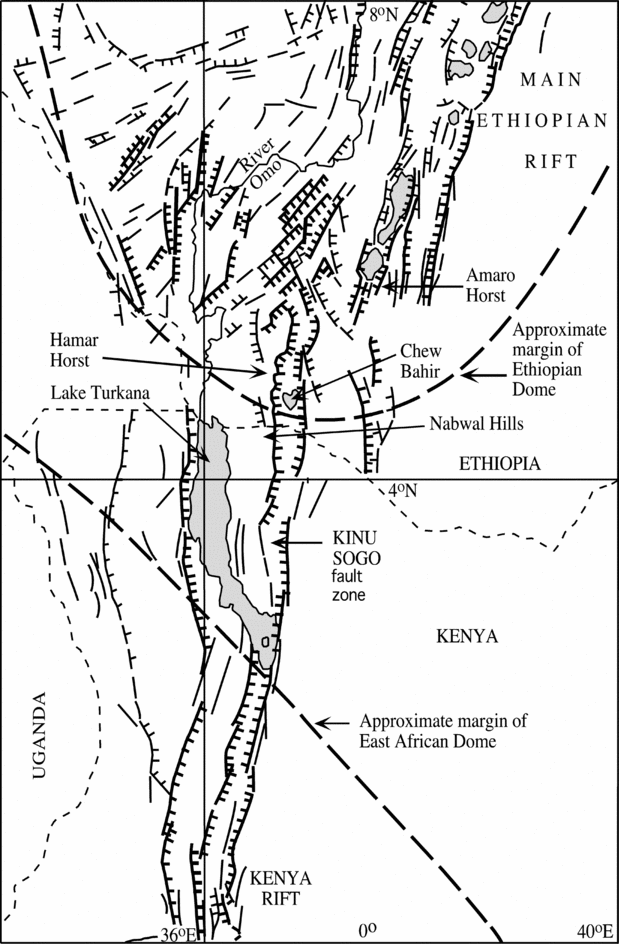
Figure 1. Tectonic map of part of the East African Rift System, modified after Davidson (Reference Davidson1983), Ebinger et al. (Reference Ebinger, Bechtel, Forsyth and Bowin1989), Morley, Ngenoh & Ego (Reference Morley, Wescott, Stone, Harper, Wigger, Day, Karanja and Morley1999), and McDougall & Watkins (Reference McDougall and Watkins2006).
The Omo–Turkana Basin is bounded by higher country, both to the east and west, considered to be relatively uplifted blocks or horsts along mainly north-trending faults. Seismic data reported by Morley et al. (Reference Morley, Wescott, Stone, Harper, Wigger and Karanja1992) and Morley (Reference Morley1999) show that major half-graben with northerly strike and up to 7 km of fill have been a feature of the region west of the Omo–Turkana Basin and Lake Turkana since at least the Late Oligocene (c. 25 Ma ago) and possibly somewhat earlier, reflecting extension across the rift of about 40 km in that time. To the east, the Nabwal Hills form a horst-like block between the Omo–Turkana Basin and Chew Bahir (McDougall & Watkins, Reference McDougall and Watkins2006). The Omo–Turkana Basin extends to an abrupt faulted margin on the west with a wide variety of rocks exposed in the horst-like uplands, themselves commonly faulted (Fig. 2). Thus, in the Labur (Lapurr) Range in the north, and also at other localities west of Lake Turkana, crystalline metamorphic rocks are exposed, unconformably overlain by a gently dipping sequence of Mesozoic sandstones. However, much of the region to the west of the Omo–Turkana Basin is covered by Cenozoic volcanic rocks with relatively minor occurrences of intercalated sediments.

Figure 2. Simplified geological maps of the region west of Lake Turkana, after Walsh & Dodson (Reference Walsh and Dodson1969), Joubert (Reference Joubert1966), Dodson (Reference Dodson1971) and Fairburn & Mathieson (Reference Fairburn and Mathieson1970). Right-side map shows only the Eocene to Miocene volcanic rocks, together with localities and measured K–Ar ages (filled circles, this study), and K–Ar and some 40Ar–39Ar ages (plus symbols) on selected samples from Boschetto, Brown & McDougall (Reference Boschetto, Brown and McDougall1992) and McDougall & Feibel (Reference McDougall and Feibel1999).
Walsh & Dodson (Reference Walsh and Dodson1969) geologically mapped a large area (~34000 km2) to the west of Lake Turkana in reconnaissance fashion over only three months, and their map remains the main source of information on the regional geology, together with mapping to the south by Dodson (Reference Dodson1971), Joubert (Reference Joubert1966) and Fairburn & Mathieson (Reference Fairburn and Mathieson1970). Oil exploration results (seismic and drilling: see Morley et al. Reference Morley, Wescott, Stone, Harper, Wigger and Karanja1992; Morley, Reference Morley1999) in the area south of Lodwar have yielded invaluable additional geological information, and localized detailed studies such as in the Lothidok Range (Boschetto, Brown &McDougall, Reference Boschetto, Brown and McDougall1992) and at Lothagam (Leakey & Harris, Reference Leakey and Harris2003) have added considerably to geological knowledge.
In this contribution we present results of a reconnaissance K–Ar dating survey on volcanic rocks mainly on samples from the region west of Lake Turkana, augmenting previous studies by Bellieni et al. (Reference Bellieni, Justin Visentin, Zanettin, Piccirillo, Radicati di Brozolo and Rita1981), Zanettin et al. (Reference Zanettin, Justin Visentin, Bellieni, Piccirillo and Rita1983), Boschetto, Brown & McDougall (Reference Boschetto, Brown and McDougall1992), Morley et al. (Reference Morley, Wescott, Stone, Harper, Wigger and Karanja1992) and McDougall & Feibel (Reference McDougall and Feibel1999). The aim of the current work is to provide age constraints on the Cenozoic volcanism displayed in the uplands, with particular emphasis on the evolution of this part of the Kenya Rift. We plot our sample locations and ages on a geological map (Fig. 2) based on that of Walsh & Dodson (Reference Walsh and Dodson1969) in the north and the maps of Dodson (Reference Dodson1971), Joubert (Reference Joubert1966), and Fairburn & Mathieson (Reference Fairburn and Mathieson1970) to the south, simplified to illustrate dominant rock types, as the relative age assignments made by Walsh & Dodson for their mapped units are not satisfactory. Where appropriate, we also discuss previously published geochronological data from volcanic rocks elsewhere in the Turkana region, and some of these localities are shown in the regional map in Figure 3.

Figure 3. Map of the Turkana region showing geographic localities and outcrops of Pliocene and Lower Pleistocene strata of the Omo Group.
2. Methods
Samples were collected on several expeditions to the area west of Lake Turkana. Although the main focus of these expeditions was on the Pliocene–Pleistocene sedimentary sequence of the Omo–Turkana Basin, opportunities were taken to sample older rocks bordering the basin. In particular, a reconnaissance traverse was made in 1987 following the road from Lowarengak, adjacent to Lake Turkana, to Lokitaung and thence to Lodwar in the south, utilizing the Walsh & Dodson (Reference Walsh and Dodson1969) map as a guide. The geochronological results from this and the earlier studies by Bellieni et al. (Reference Bellieni, Justin Visentin, Zanettin, Piccirillo, Radicati di Brozolo and Rita1981), Zanettin et al. (Reference Zanettin, Justin Visentin, Bellieni, Piccirillo and Rita1983), Boschetto, Brown & McDougall (Reference Boschetto, Brown and McDougall1992) and Morley et al. (Reference Morley, Wescott, Stone, Harper, Wigger and Karanja1992) show that there are significant problems with the stratigraphic assignments made by Walsh & Dodson (Reference Walsh and Dodson1969), although the mapping of rock types is generally sound. Unfortunately, we are only able to marginally improve the situation locally; clearly what is required is systematic and detailed geological mapping to be undertaken, also utilizing information provided by satellite imagery.
Thin-sections of all samples collected were examined under a polarizing microscope to determine their suitability for K–Ar dating. Most of the basalts collected were aphyric or with few phenocrysts or microphenocrysts, and because of their fine grain size had to be considered for dating as whole rock samples. Owing to the difficulty of obtaining reliable K–Ar ages on whole rock basalts, particular attention was paid to the crystallinity and degree of alteration of the samples. Fresh, holocrystalline basalts are expected to yield reliable and accurate K–Ar ages, but such samples are rare. Most samples deemed suitable for dating showed a high degree of crystallinity (>90%) in clinopyroxene, plagioclase, olivine and opaques, with <10% of intersertal finely or poorly crystallized material. Generally, a few per cent of alteration products, clay or chlorite, was present. Samples with lower crystallinity or more than 5% of alteration products were rejected for K–Ar dating. Alkali feldspar phenocrysts in the rhyolites were fresh and were commonly separated for dating, with the ages regarded as quite reliable.
The K–Ar age measurements were made by methods similar to those described by McDougall & Feibel (Reference McDougall and Feibel1999), with potassium determined in duplicate by flame photometry and argon measured by isotope dilution. Uncertainties in the K–Ar ages associated with the physical measurements are about 1% standard deviation. All ages are calculated using decay constants recommended by Steiger & Jäger (Reference Steiger and Jäger1977). Where earlier K–Ar age results are referred to, we give the age in terms of the Steiger & Jäger (Reference Steiger and Jäger1977) constants with the actual previously published age, if different, given in parentheses. Although Bellieni et al. (Reference Bellieni, Justin Visentin, Zanettin, Piccirillo, Radicati di Brozolo and Rita1981) and Zanettin et al. (Reference Zanettin, Justin Visentin, Bellieni, Piccirillo and Rita1983) state that the K–Ar ages in their papers are listed using the Steiger & Jäger (Reference Steiger and Jäger1977) constants, calculations from the published potassium and radiogenic argon contents in their tables show that in fact they used an earlier set of decay constants, so the recalculated ages generally are about 2.6% greater than those originally published. For the Zanettin et al. (Reference Zanettin, Justin Visentin, Bellieni, Piccirillo and Rita1983) samples, we have relied upon the locations shown in their map, because the coordinates they gave for their samples are inconsistent, noting that the minutes of latitude and longitude are given as even tens.
If the proportion of radiogenic argon is less than about 40% for rocks older than about 10 Ma, this often indicates the presence of excessive alteration, as phases such as clay generally carry large amounts of atmospheric argon reflected in the lowering of the proportion of radiogenic argon. Our results (Tables 1, 2) show that most analyses have argon that is more than 50% radiogenic.
Where possible, we have measured at least two samples in known stratigraphic relationships in order to check on consistency and gain confidence in the veracity of the reported K–Ar ages.
In the following we use the numerical time scale of Gradstein, Ogg & Smith (Reference Gradstein, Ogg and Smith2005), with the Eocene/Oligocene boundary at 33.9 Ma, the Oligocene/Miocene boundary at 23.0 Ma, and the Miocene/Pliocene boundary at 5.3 Ma.
3. Results
3.a. Basement rocks
At various localities west of Lake Turkana, metamorphic rocks are exposed in uplifted blocks, overlain unconformably by unmetamorphosed Mesozoic Lubur Sandstone or Cenozoic sequences that are generally only moderately tilted, with dips usually less than 20°. The metamorphic rocks are typically strongly deformed and of amphibolite facies; they are well described by Walsh & Dodson (Reference Walsh and Dodson1969), Joubert (Reference Joubert1966) and Dodson (Reference Dodson1971). Excellent outcrops occur in the Lapurr (Labur) Range, to the south in the Muruanachok Hills and further south in the Loperot (Lokhone) area. To the west in the hills and mountains, metamorphic rocks comprise the main outcrop in uplifted blocks.
Measurements by the K–Ar method on minerals separated from samples of basement rocks (Table 1) gave Early Palaeozoic ages, related to the Pan-African Orogeny, the effects of which are widespread in Africa (Cahen et al. Reference Cahen, Snelling, Delhal and Vail1984). In the Muruanochok Hills (Fig. 2), two samples of gneiss and schist yielded K–Ar ages on biotite between 504 and 507 Ma, with coexisting alkali feldspars giving younger apparent ages of 433 and 457 Ma, reflecting the lower closure temperature for argon retention in alkali feldspar compared with biotite. Much further south in the Loperot area, similar schists yield K–Ar ages on biotite of about 517 Ma on two samples. We believe that all these ages are simply cooling ages reflecting tectonic activity in which these basement rocks were brought to a level in the crust where cooling below about 300°C occurred a little over 500 Ma ago.
Table 1. Potassium–argon ages of minerals from metamorphic basement rocks, Turkana, northern Kenya
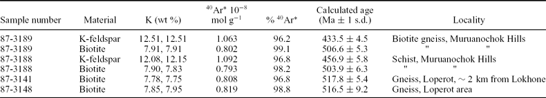
λe = 0.581 × 10⁻¹⁰ a−1; λß = 4.962 × 10⁻¹⁰ a−1; 40K/K = 1.167 × 10⁻⁴ mol/mol.
40Ar* = radiogenic argon.
3.b. Lubur Sandstone
In the vicinity of the Labur (Lapurr) Range, the Pan-African metamorphic rocks are overlain unconformably by the Lubur Sandstone (grés du Lubur of Arambourg & Wolff, Reference Arambourg and Wolff1969). This sedimentary sequence is more than 500 m thick (J. J. W. Sertich, unpub. M.S. thesis, Univ. Utah, 2006) and dips about 15° to the southwest (Walsh & Dodson, Reference Walsh and Dodson1969). It consists dominantly of coarse arkosic sandstones, conglomerates and mudstones, locally containing dinosaur, turtle and crocodilian bones, indicating a Mesozoic age (Arambourg & Wolff, Reference Arambourg and Wolff1969), most probably Cretaceous (J. J. W. Sertich, unpub. M.S. thesis, Univ. Utah, 2006). The Lubur Sandstone was mapped by Walsh & Dodson (Reference Walsh and Dodson1969) as Turkana Grits, but because sedimentary units of different age, including Miocene sediments in the nearby Lothidok Hills (Boschetto, Brown & McDougall, Reference Boschetto, Brown and McDougall1992; see also Williamson & Savage, Reference Williamson, Savage, Fostick, Renaut, Reid and Tiercelin1986), are included in this unit, the specific name proposed by Arambourg & Wolff (Reference Arambourg and Wolff1969) is much preferred. Arambourg (Reference Arambourg1935) had previously named the sequence of sediments in Lokitaung Gorge the Lubur Series.
3.c. Early basalts (Tvb1) – Lokitaung basalts
Disconformably overlying the Lubur Sandstone in Lokitaung Gorge is an essentially continuous sequence of basaltic lava flows more than 1000 m thick that extends also to the west of Lokitaung. These lavas dip about 15° to the south–southwest, and are included in a unit labelled Tvb1 by Walsh & Dodson (Reference Walsh and Dodson1969). For convenience, we informally call these lavas the Lokitaung basalts, as we do not have enough information to formally define a new formation. The basalt flows are individually up to about 50 m thick, commonly with columnar jointing well developed above the base, passing up into thinner columns or platy or weathered upper parts. Three samples from Lokitaung Gorge were sufficiently well crystallized for K–Ar dating purposes, showing only relatively minor alteration. Sample 87-3166 was collected from near the base of the sequence, from about the fourth flow above the Lubur Sandstone, and gave an age of 35.7±0.4 Ma (Table 2), whereas two samples (87-3169, 98-325) from much higher in the section, just below Lokitaung, yielded ages of 36.0±0.4 and 36.4±0.5 Ma (Table 2). These ages are concordant, suggesting that the sequence was erupted over a short interval. Raja, Reilly & Mussett (Reference Raja, Reilly and Mussett1966) reported that the lower half (~900 m) of the basalt sequence in Lokitaung Gorge has reverse palaeomagnetic polarity, whereas the upper half is predominantly of normal polarity. The normal polarity sequence presumably belongs to either C17n.1n or C16n.2n (Gradstein, Ogg & Smith, Reference Gradstein, Ogg and Smith2005). If only a single polarity change occurs in the sequence of basalts, this would be entirely consistent with eruption over a relatively short period of time.
Table 2. Potassium–argon ages of whole rock basalts and of anorthoclase from rhyolites, Turkana, northern Kenya
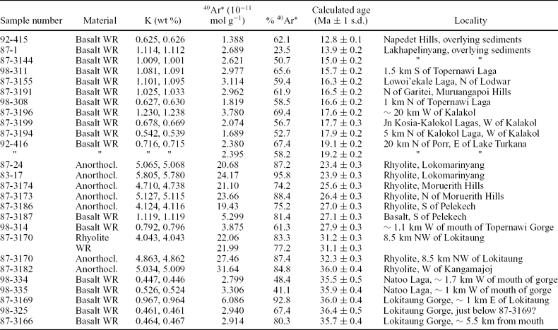
λe = 0.581 × 10⁻¹⁰ a−1; λß = 4.962 × 10⁻¹⁰ a−1; 40K/K = 1.167 × 10⁻⁴ mol/mol.
40Ar* = radiogenic argon; WR – whole rock; Anorthocl. – anorthoclase.
About 6.5 km south of Lokitaung Gorge in the valley eroded by Natoo Laga, basalts assigned to Tvb1 by Walsh & Dodson (Reference Walsh and Dodson1969) dip about 15° to the west. Two of the basalts (98-334, 98-335) from low in the exposed sequence, each aphyric and about 10 m thick, gave K–Ar ages of 35.5±0.5 and 35.9±0.4 Ma (Table 2), in excellent agreement with the ages found for the basalts in Lokitaung Gorge (Figs 2, 4). A little higher in the sequence in Natoo Laga occurs a very thick (50+ m) massive, aphyric rhyolite flow, in turn overlain by more basalts, as also noted on Walsh & Dodson's (Reference Walsh and Dodson1969) geological map.

Figure 4. Schematic sections of Eocene–Oligocene sequences in the Turkana region, with K–Ar ages shown. Lothidok ages from Boschetto, Brown & McDougall (Reference Boschetto, Brown and McDougall1992), Nabwal ages from McDougall & Watkins (Reference McDougall and Watkins2006), ages from the basalt sequence at Kalin are from Bellieni et al. (Reference Bellieni, Justin Visentin, Zanettin, Piccirillo, Radicati di Brozolo and Rita1981), with the rest of the ages from the present paper. For legend see Figure 5.
As the K–Ar results from five whole rock basalts from unit Tvb1 (Lokitaung basalts) in Lokitaung Gorge and Natoo Laga yield concordant ages averaging 35.9±0.3 Ma, there can be little doubt that the sequence is reliably dated, noting also that the potassium content of the samples ranges from 0.45 to 0.97% (Table 2).
West of Kangamajoj, on the road between Lokitaung and Lodwar, massive rhyolite flows crop out and dip about 15° to the southeast. Sample 87-3182 yielded a K–Ar age on separated anorthoclase of 36.0±0.4 Ma (Table 2, Fig. 4), providing strong evidence that at least some rhyolites mapped as Tvr by Walsh & Dodson (Reference Walsh and Dodson1969) are coeval with the predominantly basalt lava sequence of Late Eocene age. This is also in keeping with the occurrence of rhyolite within the basalt sequence in Natoo Laga, indicating that bimodal volcanism of this kind is characteristic of the earliest Cenozoic volcanism in the region.
Reilly et al. (Reference Reilly, Mussett, Raja, Grasty and Walsh1966) reported a K–Ar age of 32.6 (31.8) Ma for a basalt (260/1) from the volcanic sequence in Lokitaung Gorge and a significantly younger apparent age of about 22 Ma for a basalt (264/5) lower in the sequence. They suggested that the latter result may be accounted for by loss of radiogenic argon. Bellieni et al. (Reference Bellieni, Justin Visentin, Zanettin, Piccirillo, Radicati di Brozolo and Rita1981) and Zanettin et al. (Reference Zanettin, Justin Visentin, Bellieni, Piccirillo and Rita1983) provided K–Ar ages of 30.2 (29.6)±4.4 and 31.1 (30.4)±1.5 Ma on two basalt samples (K205, K206) that seem to be from Lokitaung Gorge (see Zanettin et al. Reference Zanettin, Justin Visentin, Bellieni, Piccirillo and Rita1983, fig. 3). Morley et al. (Reference Morley, Wescott, Stone, Harper, Wigger and Karanja1992) also reported K–Ar ages on two samples from basalt lavas from the same general area at 29.0±1.4 and 22.1±1.1 Ma (samples 85/3/14-2, 85/3/22-11), as well as ages on several basalt dykes. All these ages are significantly younger than those reported here, as well as much more scattered; we surmise that all samples have suffered loss of radiogenic argon, presumably because of variable but extensive alteration of potassium-bearing materials. In view of these difficulties we have generally not attempted to discuss all these earlier K–Ar age results in detail, noting, however, that many of the ages are broadly consistent with our present findings.
3.d. Younger basalts (Tvb2) – Kalin basalts
Walsh & Dodson (Reference Walsh and Dodson1969) mapped a group of olivine basalts as Tvb2, south and southwest of Lokitaung and northwest of Lokitaung in the Kalin area. Bellieni et al. (Reference Bellieni, Justin Visentin, Zanettin, Piccirillo, Radicati di Brozolo and Rita1981) and also Zanettin et al. (Reference Zanettin, Justin Visentin, Bellieni, Piccirillo and Rita1983) reported K–Ar ages on two samples of mugearite (K201, K202) from outcrops of Tvb2 adjacent to the Lokitaung/Lodwar road in the Kalin area, just north of the Moruerith Hills (Fig. 2). These ages are 29.9 (29.3)±1.5 and 32.2 (31.5)±1.6 Ma, respectively (Fig. 4). They point out that the ages are indistinguishable from the apparent ages they obtained on the basalts in Lokitaung Gorge, although we believe the latter ages are too young. Bellieni et al. (Reference Bellieni, Justin Visentin, Zanettin, Piccirillo, Radicati di Brozolo and Rita1981) showed that the Kalin volcanic rocks belong to an alkali basalt suite, whereas the Lokitaung basalts are transitional to tholeiitic compositions. Overall, they queried the petrographic distinctions made by Walsh & Dodson (Reference Walsh and Dodson1969) between Tvb1 and Tvb2 and concluded that they were essentially part of the same sequence. For convenience, we use the informal designation of Kalin basalts for the Tvb2 sequence in the general Lokitaung region, noting that they may be younger than the Lokitaung basalts.
A basalt sample (98-314) from a lava flow about 1 km west of the mouth of Topernawi Gorge, where the Topernawi Laga enters the Turkana Basin, yielded a K–Ar age of 27.9±0.3 Ma. This sample comes from a structurally complex zone, called the Kataboi Fault Zone by Vetel & Le Gall (Reference Vetel, Gall, Yirgu, Ebinger and Maguire2006), which appears to separate older rocks to the north from younger rocks to the south (Fig. 2). This zone may be collinear with the Buluk Fault (Key & Watkins, Reference Key and Watkins1988; Vetel & Le Gall, Reference Vetel, Gall, Yirgu, Ebinger and Maguire2006) in the Suregei (Nabwal Hills) region east of Lake Turkana (Fig. 1).
3.e. Rhyolites (Tvr)
Walsh & Dodson (Reference Walsh and Dodson1969) mapped extensive areas as rhyolites (Tvr), noting that although rhyolite flows are found sporadically interbedded with the basalts, in general they are among the youngest volcanic rocks of the region. From our dating work, based upon limited sampling, we suggest that the rhyolites have erupted mainly between 36 and 23 Ma (Table 2). As previously discussed, west of Kangamajoj, anorthoclase from a rhyolite flow yielded an age of 36.0±0.4 Ma (Figs 2, 4). Walsh & Dodson (Reference Walsh and Dodson1969, p. 19) noted that about 6.5 km northwest of Lokitaung, thin rhyolite flows are interbedded with olivine basalts assigned to Tvb2. A rhyolite (87-3170) adjacent to the road about 8.5 km northwest of Lokitaung in the Kachoda area, 0.4 km east of a road junction, gave K–Ar ages on a whole rock sample of 31.1±0.3 Ma, and alkali feldspar from the same sample gave a slightly older apparent age of 32.3±0.3 Ma (Figs 2, 4). These ages are consistent with the older of the two ages reported by Bellieni et al. (Reference Bellieni, Justin Visentin, Zanettin, Piccirillo, Radicati di Brozolo and Rita1981) for the Kalin basalts, adding credence to their measurement. This provides further evidence for bimodal volcanism.
The road to Kakuma south of the Pelekech Hills, about 90 km west of Lake Turkana, passes through basalt and rhyolite flows mapped as Tvb1 and Tvr by Walsh & Dodson (Reference Walsh and Dodson1969). A basalt (87-3187) whole rock and anorthoclase from a nearby rhyolite (87-3186) yielded indistinguishable K–Ar ages of 27.1±0.3 and 27.0±0.3 Ma, respectively (Figs 2, 4), a further demonstration of bimodal volcanism at a younger time.
Anorthoclase from two rhyolite samples, 87-3173 and 87-3174, from the Moruerith Hills, about 12 km apart along the Lokitaung–Lodwar road, gave quite similar K–Ar ages of 26.4±0.3 and 25.6±0.3 Ma, whereas distinctly younger ages of 23.4±0.3 and 23.9±0.3 Ma were obtained on anorthoclase from rhyolite flows (87-24, 83-17) at Lokomarinyang to the north (Figs 2, 4). Lokomarinyang lies at about 450 m elevation at the base of the Lorienetom Range, which reaches nearly 1750 m elevation. Cursory observation suggests that most of the range is made up of thick rhyolite flows and silicified rhyolitic tuffs. A minimum thickness of these rhyolites is on the order of 1300 m. The ages of rhyolites of the Moruerith Hills are younger than those reported by Bellieni et al. (Reference Bellieni, Justin Visentin, Zanettin, Piccirillo, Radicati di Brozolo and Rita1981) for the two mugearites from the Kalin basalts to the north, in keeping with the view of Walsh & Dodson (Reference Walsh and Dodson1969) that these rhyolites are indeed younger than basalts mapped as Tvb2.
Interestingly, however, the basalts mapped as Tvb1 in the Pelekech Hills to the west, which are the same age as the associated rhyolites, are younger than the basalts mapped as Tvb2 (Figs 2, 4). Thus, it is evident that the correlation of basalt sequences by mineralogy, as Walsh & Dodson (Reference Walsh and Dodson1969) have done, is a poor guide to age, and reinforces the views expressed by Bellieni et al. (Reference Bellieni, Justin Visentin, Zanettin, Piccirillo, Radicati di Brozolo and Rita1981) that there is little difference in mineralogy between at least some basalts mapped as Tvb1 and Tvb2.
3.f. Other younger basalts
Our dating shows that there are extensive outcrops of significantly younger basalts. Thus, just north and south of where the Topernawi Laga enters the Turkana Basin, two basalts (98-308, 98-311) yielded K–Ar ages of 16.6±0.2 and 15.7±0.2 Ma, respectively (Fig. 2). Further south, in the hills west of Kalakol, three basalt samples (87-3194, 87-3199, 87-3196) gave concordant K–Ar ages between 17.6 and 17.9 Ma (Table 2, Fig. 2), leaving no doubt that a younger sequence of basalts occurs in this area. Two other basalts north of Lodwar gave slightly younger K–Ar ages of 16.5±0.2 Ma (87-3191) and 16.3±0.2 Ma (87-3155) (see Fig. 2), quite similar to the ages for some of the basalts near Topernawi Laga. These latter two basalts come from areas mapped by Walsh & Dodson (Reference Walsh and Dodson1969) as phonolites and nephelinites labelled Tvp on their map, but we think that the two samples are fairly typical alkali basalts, although phonolites also occur in the area. Zanettin et al. (Reference Zanettin, Justin Visentin, Bellieni, Piccirillo and Rita1983) gave K–Ar data for a basanite from near Lodwar that yielded a recalculated age of 20.4 Ma, and another basanite (K51) from about 18 km northwest of Lodwar gave a K–Ar age of 26.1 (25.4) Ma. Zanettin et al. (Reference Zanettin, Justin Visentin, Bellieni, Piccirillo and Rita1983) also gave K–Ar ages on two samples (K56, K191) said to be phonolites of 18.9 (18.4) and 26.5 (25.4) Ma from near Kaibulucha and Kangamajoj, respectively. Thus, it is unclear whether the unit Tvp of Walsh & Dodson (Reference Walsh and Dodson1969) has stratigraphic significance.
In the Lothidok Range, Boschetto, Brown & McDougall (Reference Boschetto, Brown and McDougall1992) showed that a sequence of basalts at least 785 m thick, informally named the Kalakol basalts, underlies sediments and volcanic rocks of the Lothidok Formation, which is about 590 m thick. Two whole rock basalts from the lower part of the Kalakol sequence gave K–Ar ages of 27 and 28 Ma (Boschetto, Brown & McDougall, Reference Boschetto, Brown and McDougall1992), similar to ages found for a basalt in Topernawi Gorge and from Pelekech. However, just below the Lothidok Formation, high in the Kalakol basalt sequence, K–Ar ages of 17.7 and 18.0 Ma were obtained (Boschetto, Brown & McDougall, Reference Boschetto, Brown and McDougall1992), essentially identical to those found on basalts west of Kalakol (Fig. 5). As no continuous section was measured through the Kalakol basalts, the sequence may include a significant hiatus in the Lothidok Range. Hominoid fossils found in the Eragaleit beds (Fig. 4), between about 27 and 24 Ma old (Late Oligocene), were assigned to Kamoyapithecus hamiltoni by Leakey, Ungar & Walker (Reference Leakey, Ungar and Walker1995).
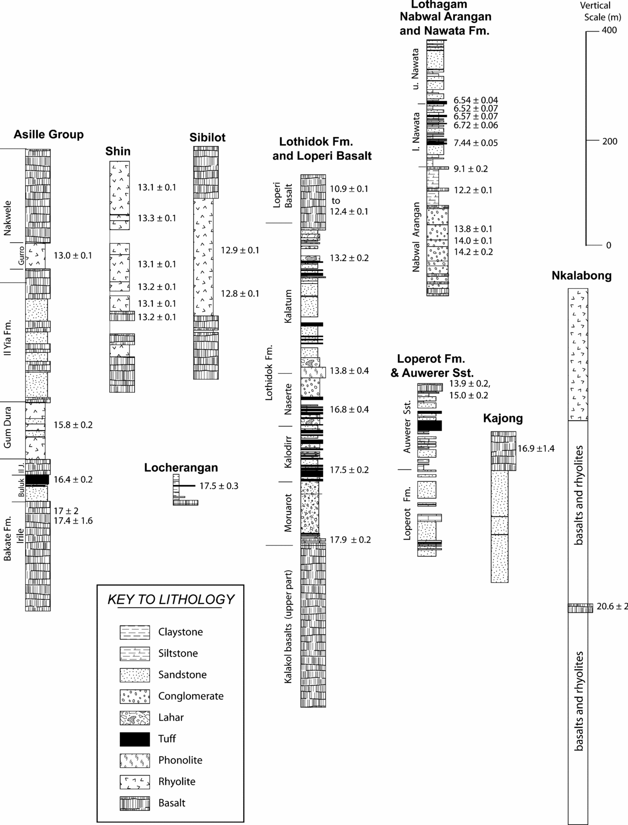
Figure 5. Schematic sections of selected Miocene sequences in the Turkana region, together with representative K–Ar and 40Ar–39Ar ages. Asille Group composite section is from Watkins (R. T. Watkins, unpub. Ph.D thesis, Univ. London, 1983; Key & Watkins, Reference Key and Watkins1988) and ages from McDougall & Watkins (Reference McDougall and Watkins1985, Reference McDougall and Watkins1988, Reference McDougall and Watkins2006), ages for Shin and Sibilot from McDougall & Watkins (Reference McDougall and Watkins1988), Lothidok section and ages from Boschetto, Brown & McDougall (Reference Boschetto, Brown and McDougall1992), section and ages for Nabwal Arangan and Nawata at Lothagam from McDougall & Feibel (Reference McDougall and Feibel1999), and the section from Nkalabong is adapted from field notes of F. H. Brown and figure 49 of Davidson (Reference Davidson1983); the age is from Brown & Nash (Reference Brown, Nash, Coppens, Howell, Isaac and Leakey1976).
The Lothidok Formation consists of sandstone, mudstone and conglomerate with a significant volcanic component, mainly tuffs (Boschetto, Brown & McDougall, Reference Boschetto, Brown and McDougall1992). Several K–Ar determinations on biotite and amphibole from tuffs and alkali feldspar from pumice, yielded ages ranging from about 18 to 13.2 Ma, generally consistent with the stratigraphic order (Figs 2, 5). The Lothidok Formation is overlain by the Loperi Basalts, which gave ages in the range 12.4 to 10.9 Ma (Boschetto, Brown & McDougall, Reference Boschetto, Brown and McDougall1992). A number of important vertebrate fossil localities, including Kalodirr and Moruarot, are known from the Lothidok Formation (Leakey & Leakey, Reference Leakey and Leakey1986, Reference Leakey and Leakey1987). North of Lothidok at Locherangan, in a tributary of Topernawi Laga, Anyonge (Reference Anyonge1991) also reported sediments about 50 m thick overlying basaltic lavas. Vertebrates, including Afropithecus, were described from the sediments, dated at 17.5±0.3 Ma on the basis of K–Ar ages of anorthoclase from a tuff interbedded with the sediments (Anyonge, Reference Anyonge1991). Well south of Lodwar at Lakhapelinyang in the Loperot area, yet another sedimentary intercalation with vertebrate fossils is known (Joubert, Reference Joubert1966), with overlying basalts yielding K–Ar ages of 13.9 and 15.0 Ma (Figs 2, 5). An age of 12.8±0.1 Ma was found for a basalt (92-415) overlying a sedimentary sequence in the Napedet Hills, again with fossil vertebrates, southeast of Lodwar (Dodson, Reference Dodson1971).
An additional age of 19 Ma reported here is from a basalt (92-416) about 20 km northwest of Porr, east of Lake Turkana, in a basaltic sequence exposed south of Allia Bay.
4. History of rifting
Davidson & Rex (Reference Davidson and Rex1980) and Davidson (Reference Davidson1983) reported K–Ar ages of 47 to 49 Ma on three analcime basalts (assigned to the Akobo basalt) overlying crystalline basement near the Ethiopia–Sudan border, about 200 km northwest of Lake Turkana, the oldest volcanic units so far known in southwest Ethiopia (Fig. 6). Other basalts from the ‘Main sequence’ yielded K–Ar ages in the range 43 to 38 Ma, Middle Eocene, on five whole rock samples from scattered localities in southern Ethiopia, within a radius of 130 to 200 km northwest to northeast of Lake Turkana (Davidson & Rex, Reference Davidson and Rex1980; Davidson, Reference Davidson1983).

Figure 6. Plot of reported K–Ar and some 40Ar–39Ar ages from volcanic rocks in the Turkana region, together with ages from the southern Main Ethiopian Rift from Ebinger et al. (Reference Ebinger, Yemane, Harding, Tesfaye, Kelley and Rex2000), and ages from southwest Ethiopia from Davidson & Rex (Reference Davidson and Rex1980) and Davidson (Reference Davidson1983). Data from the present work, for Lothagam from McDougall & Feibel (Reference McDougall and Feibel1999), for Lothidok Range from Boschetto, Brown & McDougall (Reference Boschetto, Brown and McDougall1992), Sibilot/Shin from McDougall & Watkins (Reference McDougall and Watkins1988), and Suregei from McDougall & Watkins (Reference McDougall and Watkins1985, Reference McDougall and Watkins1988, Reference McDougall and Watkins2006). The range of ages is indicated for each locality. Epoch boundary ages after Gradstein, Ogg & Smith (Reference Gradstein, Ogg and Smith2005).
As previously shown in Section 3.c, in the uplands bordering the Turkana Basin and west of the present position of the Kenya Rift, widespread eruption of transitional tholeiitic basalt lavas, the Lokitaung basalts, commenced about 36 Ma ago in the Late Eocene (Figs 3, 6). In Lokitaung Gorge, a lava pile more than 1000 m thick was erupted over a short interval. Although Walsh & Dodson (Reference Walsh and Dodson1969) mapped these lavas as extending for over 100 km latitudinally in this region, the true extent of their outcrop remains to be established. The Lokitaung basalt succession is strikingly similar in age and composition to the dominantly basaltic volcanic succession of the Nabwal Formation in the Nabwal Hills east of Lake Turkana (McDougall & Watkins, Reference McDougall and Watkins2006) in the Suregei–Asille uplands (Figs 3, 4, 6). At that time, the two areas, now about 90 km apart, would have been much closer together as the eruptions pre-date all the extension across the Kenya Rift, estimated to be about 40 km during the last 25 Ma or so (Hendrie et al. Reference Hendrie, Kusznir, Morley and Ebinger1994; Morley, Reference Morley1999). Thus, we correlate the two sequences with considerable confidence, noting that it is even possible that the two areas were essentially contiguous at the time. We suggest that the eruption of these voluminous basalts indicates an extensional regime that heralds the initiation of rifting that ultimately developed into the Kenya Rift. It is noteworthy that rhyolitic flows occur sporadically in both basalt sequences, demonstrating that bimodal volcanism was established from the earliest stages. Furman et al. (Reference Furman, Kaleta, Bryce and Hanan2006) reported a 40Ar–39Ar plateau age of 39.2±0.4 Ma for a whole rock basalt said to be from the Kajong area, east of Lake Turkana (Fig. 3), but Kajong and Porr are badly displaced on their map, so that the actual location of the sample is poorly known. None the less, the age may indicate even older basaltic activity than in the Nabwal Hills and in Lokitaung Gorge somewhere southeast of Lake Turkana.
A similar evolution is revealed in the southwestern segment of the Main Ethiopian Rift in the Amaro Horst, about 250 km northeast of Turkana (Fig. 1). In this horst, a dominantly basaltic sequence overlies metamorphic basement. Isotopic dating indicates that the volcanism occurred between about 45 and 35 Ma ago (WoldeGabriel et al. Reference WoldeGabriel, Yemane, Suwa, White and Asfaw1991; Ebinger et al. Reference Ebinger, Yemane, WoldeGabriel, Aronson and Walter1993; George, Rogers & Kelley, Reference George, Rogers and Kelley1998; Ebinger et al. Reference Ebinger, Yemane, Harding, Tesfaye, Kelley and Rex2000). Age data from this region are shown in Figure 6, after Ebinger et al. (Reference Ebinger, Yemane, Harding, Tesfaye, Kelley and Rex2000). Thus, volcanism was initiated in the Amaro Horst somewhat earlier than in northern Kenya, the younging southward having been noted previously by George, Rogers & Kelley (Reference George, Rogers and Kelley1998).
Younger Kalin basalts with some interbedded rhyolites were erupted about 31 Ma ago in the Oligocene from the K–Ar results of Bellieni et al. (Reference Bellieni, Justin Visentin, Zanettin, Piccirillo, Radicati di Brozolo and Rita1981) and those reported here. Davidson & Rex (Reference Davidson and Rex1980) and Davidson (Reference Davidson1983) reported a K–Ar age on sanidine of 32.7±1.3 Ma from a rhyolite in the Maji highlands in southern Ethiopia, about 180 km north of Lake Turkana, similar to the ages on a rhyolite reported here from near Lokitaung in the Kachoda area. Volcanism continued, with rhyolites becoming more voluminous, until at least 23.4 Ma ago in the latest Oligocene (Figs 4, 6). However, the volcanism was still bimodal in character, as shown by the ages of c. 27 Ma for rhyolite and basalt in the Pelekech Hills to the west, and the evidence for basaltic activity at about 28 Ma in Topernawi Laga. In the Nabwal Hills, east of Lake Turkana, a similar pattern is seen with the Langaria Formation ignimbrites dated at 26.9±0.2 Ma (McDougall & Watkins, Reference McDougall and Watkins2006) overlying basalts of the Nabwal Formation (Figs 4, 6).
A return to dominantly basaltic volcanism occurred at about 18 Ma ago in the Miocene, with eruptions particularly well recorded in the Kalakol and Lothidok areas. This interval probably also includes eruption of some of the volcanic rocks listed as phonolites and nephelinites (Tvp) by Walsh & Dodson (Reference Walsh and Dodson1969), and the Surma basalt of Davidson & Rex (Reference Davidson and Rex1980) in southwestern Ethiopia (Fig. 6). Locally, packages of sediments occur, such as at Lothidok where some silicic volcanism also is evident as airfall tuffs and lahars. The Lothidok Formation was deposited between about 18 and 13 Ma ago (Fig. 5), and has yielded a significant vertebrate fauna (Boschetto, Brown & McDougall, Reference Boschetto, Brown and McDougall1992; Leakey & Leakey, Reference Leakey and Leakey1987). Again there is a remarkable parallel with the geological record in the Nabwal Hills, east of Lake Turkana (Figs 1, 5), where thin sequences of vertebrate-bearing sediments of the Buluk Member in the Bakate Formation of similar age are found in restricted areas (McDougall & Watkins, Reference McDougall and Watkins1985, Reference McDougall and Watkins1988, Reference McDougall and Watkins2006; Leakey & Walker, Reference Leakey and Walker1985). The Lothidok Formation is capped by basalts with ages of 11 to 12 Ma (Boschetto, Brown & McDougall, Reference Boschetto, Brown and McDougall1992) (see Fig. 5). In the Lothagam uplifted footwall block, McDougall & Feibel (Reference McDougall and Feibel1999) dated alkali lavas and agglomerates of the Nabwal Arangan Beds in the range 14.2 to 12.2 Ma, with one basalt high in the sequence yielding an age of 9.1 Ma (Fig. 5). These volcanic rocks are in fault contact with a younger sedimentary sequence, the Nawata Formation, that was deposited in an interval from a little older than 7.5 Ma.
The seismic data and drilling in the region to the south of Lodwar, reported in detail by Morley et al. (Reference Morley, Wescott, Stone, Harper, Wigger and Karanja1992) and Morley (Reference Morley1999), showed that extension, half-graben formation and filling was a feature of the region since at least the Late Oligocene (c. 25 Ma ago), with up to 7 km of sediments and volcanic rocks in the north-trending half-graben, parallel to the present long dimension of the Turkana Basin. Although details as to how the age constraints are derived from palynological studies are not given, sediments recovered from the lower part of the 2950 m deep exploratory well, Loperot-1, are said to indicate that they are Early Oligocene or possibly Eocene in age (Morley et al. Reference Morley, Ngenoh, Ego and Morley1999, p. 28), noting that the Oligocene–Eocene boundary has an estimated age of 33.9 Ma (Gradstein, Ogg & Smith, Reference Gradstein, Ogg and Smith2005). Clearly, the sedimentary and volcanic history we see in the currently exposed landscape is only a partial record that varies from place to place, depending upon local tectonics. The evidence points to extension associated with the Kenya Rift extending back to at least 25 Ma and possibly 35 Ma ago, when significant volcanism first occurred within the region, and that the faulting associated with the extension has been a feature throughout this whole period right up until the present (Dunkelman, Rosendahl & Karson, Reference Dunkelman, Rosendahl and Karson1989). The overall geological record is fragmentary at best, depending largely upon the rocks preserved in the uplifted crustal blocks and the subsurface information. That the focus of extension has migrated to its present position from the west seems to be suggested from the seismic data reported by Morley (Reference Morley1999).
If the earliest half-graben in the Turkana region was formed in Late Eocene to Early Oligocene times (Morley et al. Reference Morley, Ngenoh, Ego and Morley1999), then it is quite reasonable to suggest that this rifting essentially coincides with the widespread basaltic volcanism in Turkana and the Nabwal Hills. In turn this indicates that initiation of rifting of this part of East Africa began rather earlier than in the Miocene, which most previous workers have suggested (e.g. Davidson & Rex, Reference Davidson and Rex1980; Ebinger et al. Reference Ebinger, Yemane, Harding, Tesfaye, Kelley and Rex2000; Bonini et al. Reference Bonini, Corti, Innocenti, Manetti, Mazzarini, Abebe and Pecksay2005). Whether rifting has continued throughout the whole interval to the present since 36 Ma ago is difficult to say, but it is not an unreasonable conclusion to reach.
Although we presently have no direct evidence of volcanism in the Turkana region in the interval 19 to 23 Ma, when volcanism continued in the southern part of the Main Ethiopian Rift (Fig. 6), this may simply reflect lack of detailed mapping, sampling and dating.
The age data and schematic sections given in Figure 5 show that volcanism, usually bimodal, is well recorded at about 13 Ma in the Asille Group, Shin and Sibilot, east of Lake Turkana (Figs 3, 5), at about the same time as the eruptions of the Nabwal Arangan alkalic basalts in Lothagam to the west of Lake Turkana. There was widespread basaltic volcanism, assigned to the Gombe Group (Watkins, Reference Watkins, Frosdick, Renaut, Read and Tiercelin1986; Haileab et al. Reference Haileab, Brown, McDougall and Gathogo2004), in the region just prior to or during the earliest stages of formation of the Omo–Turkana Basin about 4 Ma ago.
The significant differences between the volcanic histories from place to place in the Turkana region are now well documented, probably reflecting the local tectonics of extension as the Kenya Rift continued to develop regionally. In many cases the thickness of sequences of extensive basalts is on the order of 1 km, but we have not identified any clear migration of the locus of activity. The Eocene sequence is best represented near Lokitaung and in the Nabwal Hills, whereas Oligocene sequences may be exposed in the Nabwal Hills, near the centre of the modern rift at Lothidok, and also further west at Pelekech, Moruerith and Kalin. Miocene sequences are also present in the Nabwal Hills, and as far west as Napedet and Loperot.
Our work throws little new light on the importance of mantle plumes in the history of the East African domes (see Furman et al. Reference Furman, Kaleta, Bryce and Hanan2006; Rogers, Reference Rogers, Yirgu, Ebinger and Maguire2006; Pik et al. Reference Pik, Marty, Carignan, Yirgu and Ayalew2008) and the initiation of the new plate boundary between what are now known as the Nubian and Somalian plates. What is abundantly clear is that the initial extension leading to widespread basaltic volcanism began about 36 Ma ago in the Late Eocene in northern Kenya. Whether the volcanism is caused by decompression owing to lithospheric stretching or adiabatic upwelling of deeper material is debated (cf. Ebinger et al. Reference Ebinger, Yemane, Harding, Tesfaye, Kelley and Rex2000; Pik et al. Reference Pik, Marty, Carignan, Yirgu and Ayalew2008; Vetel et al. Reference Vetel, Gall, Yirgu, Ebinger and Maguire2006). Clearly some extension took place in the region at this time, possibly consequent to doming caused by the arrival of a mantle plume. The extensive volcanism in Eocene and Oligocene times no doubt influenced the location of later extension and rifting in this region. Judging from the seismic data presented by Morley et al. (Reference Morley, Wescott, Stone, Harper, Wigger and Karanja1992), extension was significant by Oligocene times (cf. the thick sequence deposited in the Lokichar Basin), although constraints on the numerical age of this basin are not very precise.
Acknowledgements
We thank Robyn Maier and John Mya in particular for their assistance in processing samples in the K–Ar laboratory. In addition, we thank J. M. Harris and R. Pik for helpful comments on the manuscript.
Appendix 1. Sample localities
Coordinates are usually only given to 0.001° (about 100 m). They have mainly been estimated using Google Earth imagery, in many cases following transfer from locations on aerial photos. Samples are listed in the same order as their ages are listed in Tables 1 and 2, from the base upward.
87-3148: Biotite gneiss, SE corner of South of Lodwar 1:125000 map sheet (Dodson, Reference Dodson1971). Foliation strikes 005° and dips 10 to 15° to the east. Bearing to Kapeltukei 55° magnetic, and 300° to Kaureta Authrui.
87-3141: Biotite gneiss, Loperot area, near southern end of outcrop of metamorphic basement, bearing to Lokhone 4° magnetic, about 2 km; 2.533°N, 35.977°E.
87-3188: Biotite schist, on road, south of Nakwazuro; 3.485°N, 35.286°E.
87-3189: Biotite gneiss, near southern end of Muruanochok Hills, where road cuts through; 3.411°N, 35.338°E.
87-3166: Basalt lava flow at least 40 m thick, third or fourth flow above base of basalt sequence in Lokitaung Gorge, dipping 10 to 15° to the west southwest. About 5.5 km up gorge from mouth; 4.267°N, 35.792°E.
98-325: Basalt lava flow, platy and aphyric, about 15 m thick, in Lokitaung Gorge, just below Lokitaung; 4.269°N, 35.768°E.
87-3169: Basalt lava flow, columnar and aphyric, in Lokitaung Gorge about 0.5 km east of Lokitaung; 4.265°N, 35.761°E.
98-335: Basalt from platy, aphyric flow about 5 m thick in Natoo Laga. Lavas dipping about 15° to the west; 4.209°N, 35.818°E.
98-334: Basalt from aphyric lava flow about 10 m thick in Natoo Laga; 4.210°N, 35.814°E.
87-3182: Rhyolite, grey and thick lava which appears to dip about 15° to the southeast. On road between Lokitaung and Lodwar west of Kangamajoj, where the road turns south southwest; 3.726°N, 35.343°E.
87-3170: Rhyolite lava flow at least 10 m thick with columnar jointing. On Lokitaung–Lodwar road, about 8.5 km from Lokitaung, and 0.4 km east of junction with a road heading north; 4.315°N, 35.706°E.
98-314: Basalt lava, aphyric and at least 10 m thick interbedded with palagonitic breccia and clastic sediments, about 1.1 km west of where Topernawi Laga enters western margin of the Turkana Basin; 3.854°N, 35.720°E.
87-3187: Basalt lava, aphyric, and dipping about 10° to the west on road toward Kakuma, south of Pelekech Hills. Rhyolite flows above; 3.638°N, 35.014°E.
87-3186: Rhyolite, a welded ignimbrite, on road to Kakuma in southern flanks of Pelekech Hills; 3.638°N, 35.014°E.
87-3173: Rhyolite on Lokitaung–Lodwar road, about 7.5 km southwest of junction with the Kalin road, west of Lokitaung and north of the Moruerith Hills. Sampled from boulders rather than from in situ; 4.304°N, 35.508°E.
87-3174: Rhyolite, probably a lava flow, which appears to dip about 10° to the southwest, on Lokitaung-Lodwar road about 29.5 km south southwest of the Kalin road junction, and west of the Moruerith Hills; 4.136°N, 35.467°E.
83-17 (LOR-9): Rhyolite, Lokomarinyang, northwest of Lokitaung; 5.037°N, 35.650°E.
87-24: Rhyolite, Lokomarinyang, northwest of Lokitaung; 5.037°N, 35.650°E.
92-416 (K89-3462): Basalt from low hills where track crosses a steep gully north of Sera Iltomia, about 20 km north of Porr, east of Lake Turkana; 3.038°N, 36.409°E.
87-3194: Basalt, olivine phyric, dipping 5 to 10° to the west, underlying sediments of the Turkana Basin, about 5 km north of Kalokol Laga, west of Kalokol. Aerial photograph RAF812/0130/219138; 3.517°N, 35.664°E.
87-3199: Basalt, aphyric lava flow, near junction of two arms of Kalokol Laga, east of base camp, with Turkana Basin sediments overlying; 3.447°N, 35.672°E.
87-3196: Basalt lava flow about 5 m thick, nearly flat-lying, in small laga, in hills about 20 km west of Kalokol. 3.531°N, 35.707°E.
98-308: Basalt lava flow, below sediments of the Turkana Basin adjacent to its western margin, about 1 km north of Topernawi Laga; 3.871°N, 35.807°E.
87-3191: Basalt lava flow, aphyric and nearly horizontal on Lokitaung–Lodwar road, north of Garitei and about 27 km north of Lodwar, north of Muruangapoi Hills, about 1 km into outcrop marked as Tvp on the geological map by Walsh & Dodson (Reference Walsh and Dodson1969); 3.295°N, 35.480°E.
87-3155: Basalt in Lowoi'ekale Laga, about 11 km west by south of base camp (Kosia), aerial photograph RAF812/0125/060093; 3.316°N, 35.592°E.
98-311: Basalt lava flow with some plagioclase phenocrysts, columnar jointed and dipping about 5° to the east. About 2 km west of Turkana Basin sediments. Locality about 2 km south of Topernawi Laga; 3.838°N, 35.645°E.
87-3144: Basalt lava flow, aphyric and columnar jointed, above sediments at Lakhapelinyang, bearing to Lokhone 151° magnetic in Loperot area, south of Lodwar; 2.564°N, 35.987°E.
87-1 (B-13): Basalt lava flow overlying sediments at Lakhapelinyang, Loperot area; 2.479°N, 35.928°E.
92-415 (K89-3453): Basalt lava flow overlying sediments at the northern end of the Napedet Hills, south of Lodwar; 2.96°N, 35.87°E.


