Introduction
The West Antarctic rift system (WARS) crosscuts the Antarctic continent (Fig. 1a). The main phase of WARS extension occurred in the Mesozoic (Tessensohn & Wörner Reference Tessensohn and Wörner1991, Luyendyk Reference Luyendyk1995). In the period since the mid-Cretaceous, modest extension has been observed on the western part of WARS in the western Ross Sea (Stock & Cande Reference Stock and Cande2002, Davey & De Santis Reference Davey and De Santis2006). Cenozoic alkali magmatism in Victoria Land is fundamentally related to WARS (Tessensohn & Wörner Reference Tessensohn and Wörner1991).

Fig. 1 Locality of Gandalf Ridge. a. Map of Antarctica showing the western edge of WARS, indicated by the thick dashed line after LeMasurier Reference LeMasurier2008, and Transantarctic Mountains, which separate East and West Antarctica (inset). The McMurdo Volcanic Group crops out between Cape Adare in the north and Mount Early in the south. NVL = northern Victoria Land, SVL = southern Victoria Land. b. Map of the Erebus volcanic province. Gandalf Ridge is located on the northern flanks of Mount Morning, c. 100 km south-west of Mount Erebus. The dashed line represents the fault zone forming the western boundary of WARS. Hidden and Garwood valleys (approximate position, Jones Reference Jones1996).
The paucity of available structural data on WARS compared to continental rift systems of similar magnitude, such as the East Africa rift, or the Basin and Range province of the western United States, presents major difficulties in its interpretation. For example, there is debate on the calculated amount of crustal extension (Müller et al. Reference Müller, Gohl, Cande, Goncharov and Golynsky2007), which models of extensional regime controlled crustal thinning (Storti et al. Reference Storti, Balestrieri, Balsamo and Rossetti2008), and even whether rifting is still ongoing (Walcott Reference Walcott1998, Siddoway et al. Reference Siddoway, Baldwin, Fitzgerald, Fanning and Luyendyk2004). This study addresses the question of whether rifting has occurred since the Pliocene by integrating field, petrographic, and geochronological data.
An accumulation of different lines of evidence including: 1) the observation of Pliocene–Quaternary faults (Behrendt & Cooper Reference Behrendt and Cooper1991, Jones Reference Jones1996), 2) the localization of earthquakes along rifted sections of the Antarctic plate (Behrendt et al. Reference Behrendt, Saltus, Damaske, McCafferty, Finn, Blankenship and Belt1996, Reading Reference Reading2002), 3) the presence of active volcanoes (Mount Melbourne in northern Victoria Land and Mount Erebus in southern Victoria Land, (Fig. 1a, LeMasurier & Thomson Reference LeMasurier and Thomson1990), 4) atypically high heat flow along the western margin of WARS (Della Vedova et al. Reference Della Vedova, Pellis, Trey, Zhang, Cooper and Makris1997), and 5) initial GPS study results indicating that deformation in WARS is still occurring (Negusini et al. Reference Negusini, Mancini, Gandolfi and Capra2005, Rossetti et al. Reference Rossetti, Storti, Busetti, Lisker, Di Vincenzo, Laufer, Rocchi and Salvini2006), means that there is a general agreement that WARS is still an active system. Yet onshore evidence of Cenozoic activity along the fault traces that mark the western boundary of WARS have only been rarely observed. The problem is most acute in southern Victoria Land, where the sea floor is covered by the Ross Ice Shelf (Fig. 1a & b), in addition to extensive ice cover onshore. Known examples of onshore faulting include Pliocene–Quaternary faults in the Hidden and Garwood valleys in the Transantarctic Mountains (Jones Reference Jones1996, Fig. 1a), and (maximum) Miocene aged faults crosscutting Gandalf Ridge (Fig. 1b), which crops out in the Ross Sea (Muncy Reference Muncy1979, Kyle & Muncy Reference Kyle and Muncy1989).
Gandalf Ridge has been the subject of a Masters thesis (Muncy Reference Muncy1979), from which petrography and geochemistry (Kyle & Muncy Reference Kyle and Muncy1978), a geology map (Muncy Reference Muncy1979), and five K–Ar ages on felsic dykes and basic volcanic blocks (Kyle & Muncy Reference Kyle and Muncy1989), have been published. An additional K–Ar age determination on a hawaiite dyke at Gandalf Ridge, specimen OU 78654, was undertaken to complement the existing geochronological dataset at Gandalf Ridge, and was initially reported in Martin et al. (Reference Martin, Cooper and Dunlap2010). Gandalf Ridge has been re-visited in this study. New mapping and review of recently published isotope work has identified a young dyke offset by faults at Gandalf Ridge. Age determination of the crystallization age of the dyke constrains fault movement on WARS. The sense of movement and amount of horizontal offset on the faults has been determined, and the whole ridge has been re-mapped.
Geological framework
Three physiographic features dominate Victoria Land geology (Fig. 1): 1) the Transantarctic Mountains, 2) WARS, and 3) the Cenozoic, alkali rocks of the McMurdo Volcanic Group. The Transantarctic Mountains which border East Antarctica to the east (Fig. 1a) are dominantly composed of late Precambrian–Cambrian Ross Orogeny rocks (Borg & DePaolo Reference Borg and DePaolo1991, Stump Reference Stump1992, Reference Stump1995). These are unconformably overlain by Devonian–Jurassic meta-sediments of the Beacon Supergroup (Barrett Reference Barrett1981, Woolfe & Barrett Reference Woolfe and Barrett1995), into which the Ferrar dolerite was injected, mainly as sills, during the Jurassic (Elliot Reference Elliot1992, Heimann et al. Reference Heimann, Flemming, Elliot and Foland1994). The Transantarctic Mountains form the western shoulder of WARS in Victoria Land (Fig. 1a).
WARS (Fig. 1a) is a predominantly aseismic region (3000 x 750 km2) of stretched continental crust (Behrendt & Cooper Reference Behrendt and Cooper1991, Bannister et al. Reference Bannister, Yu, Leitner and Kennett2003, LeMasurier Reference LeMasurier2008). Rifting in Victoria Land has been episodic, commencing in the Early Cretaceous and continuing in the Cenozoic (Davey & Brancolini Reference Davey and Brancolini1995, Behrendt Reference Behrendt1999, Hamilton et al. Reference Hamilton, Luyendyk and Sorlien2001). The Transantarctic Mountain range bounding fault array, and the long-axis of basins in Victoria Land, trend sub-parallel to the Transantarctic Mountain front (north–south, Storti et al. Reference Storti, Balestrieri, Balsamo and Rossetti2008). Minor faults, oblique to the trend of the Transantarctic Mountains, are identified in Victoria Land from field mapping and remote sensing data, such as Landsat images, aeromagnetic surveys, and aerial photographs (Fitzgerald Reference Fitzgerald1992, Damaske et al. Reference Damaske, Behrendt, McCafferty, Saltus and Meyer1994, Wilson Reference Wilson1995, Salvini et al. Reference Salvini, Brancolini, Martina, Storti, Mazzarini and Coren1997, Wilson Reference Wilson1999). These structures have been interpreted as a Cenozoic overprint of dextral transtensional faults (north-east–south-west) that reflect the changing overall plate motion in Antarctica from one of pure extension, to dextral transtension (Wilson Reference Wilson1992, Reference Wilson1995, Salvini et al. Reference Salvini, Brancolini, Martina, Storti, Mazzarini and Coren1997, Storti et al. Reference Storti, Balestrieri, Balsamo and Rossetti2008).
The Cenozoic, alkaline, McMurdo Volcanic Group crops out in the western part of WARS, between Cape Adare to the north and Mount Early to the south (Fig. 1a). It is subdivided into three provinces (Kyle & Cole Reference Kyle and Cole1974, Kyle Reference Kyle1990): Hallett and Melbourne volcanic provinces in northern Victoria Land, and Erebus volcanic province in southern Victoria Land (Fig. 1b). Mount Morning crops out in the south-western corner of the Erebus volcanic province (Fig. 1b). It sits astride the proposed trend of the main Transantarctic Mountain range-bounding fault (Paulsen & Wilson Reference Paulsen and Wilson2007, Wilson et al. Reference Wilson, Damaske, Moller, Tinto and Jordan2007, Storti et al. Reference Storti, Balestrieri, Balsamo and Rossetti2008). Gandalf Ridge is a low promontory exposed on the northern flank of Mount Morning near sea level (Fig. 1b).
Geology of Gandalf Ridge
Gandalf Ridge is approximately 2.5 km long by 0.4 km across (Fig. 2). It stands out from the rest of the outcrop on the northern facing flanks of Mount Morning due to its lighter colour and lack of parasitic vents (Fig. 2). Gandalf Ridge has low relief, is smoothed over, and has a maximum elevation of 150 m a.s.l. (Fig. 2). Basement rocks are exposed at its southern extremity. Sitting above the basement is a chaotic deposit of matrix-supported volcanic and sedimentary blocks, crosscut by younger, ENE–WSW trending, mainly coherent, felsic and hawaiite dykes. All units on Gandalf Ridge are offset by approximately north–south trending faults (Fig. 3). A fuller account of the petrography and geochemistry described in this section is available in Martin (Reference Martin2009).

Fig. 2 Oblique aerial photograph of Gandalf Ridge (foreground) looking south-east. The summit of Mount Morning is out of frame to the top right. Gandalf Ridge has a smooth, low-lying topography in comparison to elsewhere at Mount Morning. The lighter colour of the outcrop on Gandalf Ridge is a result of the numerous felsic dykes. The orientation of the dykes and faults are shown. Photograph taken by J. Cottle.

Fig. 3 a. Geological map of Gandalf Ridge. The map is an updated version from Muncy Reference Muncy1979. b. Enlarged section of the geology of Gandalf Ridge, showing the locality of samples with age determinations. The locality of the felsic sample dated 15.5 ± 0.5 Ma is described only as ‘Gandalf Ridge’ (Kyle & Muncy Reference Kyle and Muncy1989), so is not included in this figure. The feathered arrow points to a felsic dyke that is discussed in the text. c. Rose diagram of strike directions of dykes and faults at Gandalf Ridge. All dips are ± 85°. The approximate trend of the Transantarctic Mountain front in the vicinity of Gandalf Ridge is also shown for comparison.
Basement
The stratigraphically lowest rocks exposed at Mount Morning crop out at two localities at the southern end of Gandalf Ridge within 300 m of each other (Fig. 3a). The larger of the two crops out over an area 100 x 60 m2 (Fig. 3a). Rock types comprise granitic rocks and meta-sedimentary schists. The meta-sedimentary schist consists of millimetre- to centimetre-scale alternating light and dark bands (Fig. 4a). The light bands consist of rounded grains of diopside (1 mm), quartz (1 mm), plagioclase (0.1 mm), and amphibole (⪡ 0.1 mm). The dark bands have equigranular (0.3 mm), rounded grains of biotite, quartz, amphibole, and diopside. The granite is a holocrystalline, phanerocrystalline, equigranular (1–2 mm) rock with crystals of sanidine, plagioclase, microcline, quartz, and biotite. Myrmekitic intergrowths are observed, and rare feldspathic oikocrysts enclose chadacrysts of biotite and/or quartz. These rock types are unique in outcrop at Mount Morning.

Fig. 4 Hand specimen photographs. a. Meta-sedimentary schist that forms part of the basement to Gandalf Ridge and Mount Morning. b. Block of volcaniclastic arenite in the Gandalf Ridge diamictite deposit.
Chaotic (diamictite) deposit
The majority of Gandalf Ridge is a lithified, chaotic deposit consisting of individual blocks up to 4 m in diameter of predominantly uniform volcanic rock types. Interspersed amongst the volcanic blocks are sedimentary blocks of bedded sandstone (Fig. 4b). The volcanic rocks make up c. 90% of the blocks and the sedimentary blocks the remainder. The blocks are supported within a fine-grained matrix. Gandalf Ridge is considered to be a single formation.
The volcanic blocks are typically aphyric and black in hand specimen. They have a mugearite composition (Muncy Reference Muncy1979, Martin Reference Martin2009). In thin section a fine-grained, trachytic groundmass texture is composed of euhedral plagioclase laths. Spherulites of feldspar are occasionally observed. Normative CIPW (Cross et al. Reference Cross, Iddings, Pirsson and Washington1902) compositions (Martin Reference Martin2009) are dominated by plagioclase (53%), with lesser amounts of hypersthene (9%) and quartz (0.8%). The sedimentary blocks are volcaniclastic arenites. Millimetre scale bedding is evident in hand specimen (Fig. 4b). In thin section there is typically a fining of framework grains from granules (3 mm) to medium-grained sand (0.3 mm). The finest beds are ungraded coarse siltstones (0.05 mm). Framework grains are oblate, rounded, and well-sorted volcanic lithics showing a composition of either very fine-grained, equigranular, euhedral crystals of quartz and feldspar in a trachytic groundmass, or a trachytic groundmass including quartz-filled amygdales. Framework grains account for < 15% of the rock volume. They occur in a silt matrix of quartz grains.
The blocks are randomly orientated throughout the deposit. In the sedimentary blocks orientation can be determined from the bedding planes. The volcanic blocks are subject to a fissile fracturing. These fractures are consistently orientated within individual blocks, but between adjacent blocks or groups of blocks there is no common orientation (Fig. 5a). The fractures within each block are controlled by a primary fabric (i.e. the trachytic texture in the groundmass) and thus are a reliable indicator of block orientation.

Fig. 5 Photo plate of Gandalf Ridge. a. Outcrop scale photograph of matrix supported volcanic blocks in the diamictite. The chaotic orientation of the blocks is defined by a fissile fracturing. b. Photograph of the matrix material at Gandalf Ridge. This is a clast-supported rock of volcanic clasts with void space (black) in between. The clast orientation is defined by a groundmass trachytic texture - the clast orientations are random across the field of view. c. Photograph of the hawaiite dyke on Gandalf Ridge offset by a fault that is interpreted as an onshore continuation of WARS fault array. Age determination of this dyke constrains movement to < 3.88 ± 0.05 Ma.
The blocks are supported in a fine-grained, cream coloured matrix. In thin section this matrix is brecciated (Fig. 5b), with grain size varying between very fine-grained sand (0.1 mm) and pebble sized (> 4 mm), enclosed in quartz or calcite cement. Clasts are moderately to poorly sorted, oblate, and angular to sub-angular. All clasts have a volcanic origin, with 98% of clasts having a fine-grained trachytic groundmass, and 2% composed of partially welded tuff. The orientation of individual clasts in the groundmass breccia is indicated by the foliation of the trachytic, groundmass texture. The clast orientation is random (Fig. 5b & c).
Felsic dykes crosscutting Gandalf Ridge
An alkaline–peralkaline, rhyolitic–trachytic (felsic) suite has been emplaced at Gandalf Ridge (Muncy Reference Muncy1979, Martin Reference Martin2009). The felsic dykes are 0.5–1 m wide, strike c. 085° (Fig. 3b & c), and are sub-vertical. The contact between a typical dyke and the diamictite is sharp and curvi-planar. In hand specimen a typical dyke is cream to pale grey in colour. Phenocrysts of feldspar are evident. In thin section all dykes are hypocrystalline (10–30% glass), microcrystalline, and have a porphyritic texture. Subhedral phenocrysts, commonly forming glomerocrysts, of skeletal sanidine (1–4 mm) and embayed quartz (0.5–2 mm) are common in all samples. Quartz and calcite fill small vesicles (1–2 mm). The groundmass texture is trachytic (hyalopilitic) with laths of plagioclase and varying percentages of intersertal glass, quartz, and sanidine. Crystal size varies greatly between 0.03 mm and 0.2 mm. Spherulites of plagioclase are rarely present in the groundmass. At least three generations of trachyte dyke emplacement are clear from crosscutting relationships in the field.
Hawaiite dyke crosscutting Gandalf Ridge
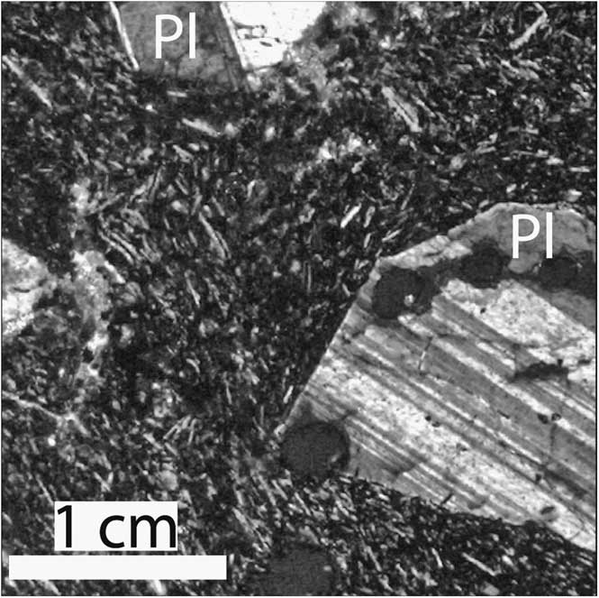
The hawaiite dyke (Martin Reference Martin2009) is 0.7 m wide, striking 090–095° (Fig. 3b & c), and is sub-vertical. The contact between the dyke and wall rock is sharp and curvi-planar. There is no chill-margin at the contact. In hand specimen the dyke is a pale-cream colour, with phenocrysts of fresh plagioclase feldspar up to 1 cm. The hawaiite dyke can be distinguished from the felsic dyke suite in the field by its phenocryst size and abundance, the fresh character of the hand specimen, lack of alteration, and colour index. In thin section the rock is porphyritic, with medium-grained phenocrysts of plagioclase, in a fine-grained, intersertal groundmass with a trachytic texture (Fig. 6). Phenocrysts are typically euhedral to anhedral, with skeletal shapes, and may form glomerocrysts or be zoned.
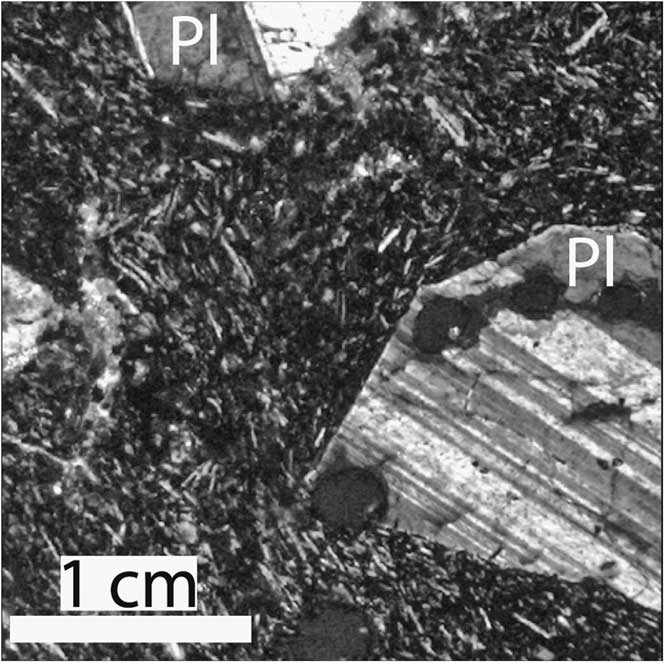
Fig. 6 Photograph of the Gandalf Ridge hawaiite dyke (OU 78654) in thin section under cross-polarized light. This specimen is housed in the University of Otago specimen collection. The age of this specimen is 3.88 ± 0.05 Ma. Phenocrysts of plagioclase (Pl) can be seen in a fine-grained groundmass of plagioclase laths with a trachytic texture.
Faulting
Several fault traces trending approximately north–south crosscut Gandalf Ridge (Fig. 3). They have offset the basement rocks, diamictite, and all dykes (Figs 3 & 5c). Faults continue for the length of Gandalf Ridge, a distance of > 2.5 km, before being obscured at both ends by either sea ice or moraine (Fig. 3). Individual fault zones are up to 20 cm wide. White clay fault gouge occurs in many fault traces, and Kyle & Muncy (Reference Kyle and Muncy1989) recorded silicification in some fault traces. No pseudotachylytes are observed.
The fault traces are sub-parallel to the trend of the adjacent Transantarctic Mountain front, and the inferred trend of the active shoulder of WARS. The rose diagram in Fig. 3c illustrates the sub-parallelism of the Transantarctic Mountains trend to the measured fault traces on Gandalf Ridge. The regional significance of the Gandalf Ridge faults is unknown (Kyle & Muncy Reference Kyle and Muncy1989), however, their common alignment with WARS trend in southern Victoria Land (Fig. 3c), their frequency (several on Gandalf Ridge), their length (> 2.5 km, Fig. 3a), and the fact they have cut basement and several generations of volcanic rocks, suggest they are of regional significance (Kyle & Muncy Reference Kyle and Muncy1989). We interpret these structures as the on-land continuation of WARS fault array.
On Gandalf Ridge a single east–north-east trending hawaiite dyke is crosscut by several fault traces (Fig. 3). The hawaiite dyke is an excellent marker horizon for recording horizontal displacement along the fault trace. The offset dyke indicates a dextral sense of displacement. The maximum horizontal offset was 6 m (Fig. 5c). The cumulative offset over all the fault traces is very close to 6 m (Fig. 3b). The low relief on Gandalf Ridge and the vertical dip of offset dykes means that no vertical offset could be measured on the north–south faults. The Gandalf Ridge faults have offset the ENE–WSW trending dykes.
Once 6 m of offset has been constrained on the fault in Fig. 3b it is possible to hypothetically match up portions of the felsic dykes that crosscut the same fault. There is no field evidence to support matching the felsic dykes across the fault except for the measured offset provided by the hawaiite dyke. The feathered arrow in Fig. 3b points to a felsic dyke that is offset by the fault with the 6 m of measured, dextral offset. It is probable that the two portions of felsic dyke that are within < 5 m of each other either side of the fault, were originally one coherent dyke (though it is not impossible that they are unrelated) based upon their close proximity, and the outcrop morphology which forms a recumbent ‘y’ shape that would be unlikely to match up across a fault by chance. This suggests, that on this particular fault, the offset between the hawaiite dyke and the felsic dyke marked with the feathered arrow (Fig. 3b) is close to equal.
Geochronology
Details of rock type, location, and age from this and existing studies, are presented in Table I and shown in Fig. 3. Geochronology (Table I) shows that the dated volcanic block, equivalent to the majority of blocks within the diamictite, had been erupted by 18.7 ± 0.3 Ma. The felsic dykes were emplaced into the diamictite by 17.6 ± 0.6 Ma, and continued to be emplaced until 15.5 ± 0.5 Ma. The hawaiite dyke (OU 78654) was emplaced by about 3.88 ± 0.05 Ma.
Table I Age determinations at Gandalf Ridge, Antarctica.

All ages were determined on whole rock using the K–Ar method. See the appropriate reference (and references therein) for methodology and geochemistry: M et al. = Martin et al. Reference Martin, Cooper and Dunlap2010, K&M (1989) = Kyle & Muncy Reference Kyle and Muncy1989, with ages re-calculated from Muncy Reference Muncy1979. Rock types: C. Trachyte = comendite trachyte, P. Trachyte = peralkaline trachyte.
Discussion and conclusions
The rock types of the basement cropping out at Gandalf Ridge are very similar to Ross Orogen rock types found in the adjacent Transantarctic Mountains (Muncy Reference Muncy1979, Kyle & Muncy Reference Kyle and Muncy1989). The most likely correlation of these lithologies is to the Late Precambrian–Cambrian Skelton Group and Granite Harbour Intrusives, part of the Ross Orogen that make up the Transantarctic Mountains (Borg & DePaolo Reference Borg and DePaolo1991, Stump Reference Stump1995, Cook & Craw Reference Cook and Craw2002).
Previous workers have interpreted Gandalf Ridge as a mud or maar volcano, or diamictite (Muncy Reference Muncy1979, Kyle & Muncy Reference Kyle and Muncy1989). Mud and maar volcanoes are typically characterized by a supporting matrix with graded bedding or laminations (Robertson & Party Reference Robertson1996, Van de Meer Reference Van de Meer1996), this is not observed at Gandalf Ridge. An additional mechanism is needed to explain the chaotic nature of the deposit at both the macroscopic and microscopic levels (Fig. 5a & b). This mechanism needs to explain: 1) the scale of the deposit, 2) the mixing of sedimentary and volcanic rock types at the macroscopic and microscopic level, 3) the random orientations of the macroscopic blocks that cause a chaotic appearance in outcrop, 4) the matrix-supported nature of the macroscopic blocks, 5) the random orientations of the microscopic blocks in the matrix that cause a chaotic appearance in thin section, and 6) a prevailing ‘block-in-matrix fabric’. Diamictite (Flint et al. Reference Flint, Sanders and Rodgers1960) is an appropriate description of the Gandalf Ridge deposit, as suggested by Kyle & Muncy (Reference Kyle and Muncy1989). Alternatively, the characteristics also match the typical description of an olistostrome deposit (Pini Reference Pini1999). A diamictite or olistostrome can be a mass gravitational deposit typically forming at the foredeep of tectonic nappes from subaqueous slope failure at thrust fronts, or via debris flows and slide accumulation from submarine slopes or fault scarps (Pini Reference Pini1999). Failures could be caused by seismic activity (including fault movement and/or volcanic activity), or be gravity induced. The timing of diamictite or olistostrome formation at Gandalf Ridge is constrained between the eruption of the dated block with a mugearite composition at about 18.7 ± 0.3 Ma and the emplacement of the oldest, coherent felsic dyke across the diamictite, at 17.6 ± 0.6 Ma.
The hawaiite dyke at Gandalf Ridge has the same orientation as the older felsic dyke suite (Fig. 3c). The simplest explanation for this is that the younger, hawaiite dyke utilized the same pathways as the felsic dyke suite. The exploitation of the same pathways suggests a significant stress field in the crust that persisted for at least 13 million years. The orientations of the Gandalf Ridge dykes are sub-parallel to the elongation direction of the Mount Morning summit caldera. The summit caldera has also been suggested to reflect stress-induced magma chamber elongation (Paulsen & Wilson Reference Paulsen and Wilson2007, Paulsen unpublished data).
The dextral offset to the Gandalf Ridge faults fits with kinematic models from southern Victoria Land, where a regime of dextral transtension along WARS is proposed to have been the dominant plate motion direction in Antarctica since the Cenozoic (Wilson Reference Wilson1992, Reference Wilson1995, Salvini et al. Reference Salvini, Brancolini, Martina, Storti, Mazzarini and Coren1997). A sinistral sense of displacement along Cenozoic aged faults in the Transantarctic Mountains (southern Victoria Land, the location is shown in Fig. 1a) is recognized by Jones (Reference Jones1996) as “inconsistent with the predicted Cenozoic north-west–south-east dextral oblique extensional regime in south Victoria Land”. Sinistral displacement is attributed to minor clockwise rotation of crustal blocks in the Transantarctic Mountains (Jones Reference Jones1996). No vertical movement could be measured on the Gandalf Ridge faults, however, since they are inferred to be part of WARS that formed as a response to continental extension, it is likely that there must be a down to the east dip-slip component to the fault movement.
Age determination of the hawaiite dyke (Martin et al. Reference Martin, Cooper and Dunlap2010, Table I) offset by the Gandalf Ridge faults shows faulting in WARS has been active since 3.88 ± 0.05 Ma. There is no geochronological information available for Gandalf Ridge between 15.5 ± 0.5 and 3.88 ± 0.05 Ma. If movement along the Gandalf Ridge faults had been continuous or episodic over the intervening 11.5 million years, there would be a large difference between the offset observed on the c. 16 Ma felsic dyke suite, and the 3.88 ± 0.05 Ma hawaiite dyke, however, the difference is minimal (Fig. 3). This suggests that fault movement was minimal during this period, and at the Gandalf Ridge locality, the majority of the 6 m of fault movement was confined to the period since emplacement of the 3.88 ± 0.05 Ma hawaiite dyke. Extrapolating movement on the Gandalf Ridge faults to the whole of the WARS would suggest an average movement of 0.0015 mm yr-1 since the late Pliocene. This rate is low in comparison to initial reports from long time series analyses of GPS permanent stations reported from Terra Nova Bay (Fig. 1a), northern Victoria Land, which estimate horizontal rates of movement in the order of millimetres per year (Negusini et al. Reference Negusini, Mancini, Gandolfi and Capra2005) or typical rates of movement along the Wasatch fault zone (Basin and Range province) of 3 mm yr-1 (Velasco et al. Reference Velasco, Bennett, Johnson and Hreinsdóttir2009) or the Asal rift (East Africa) of 11–17 mm yr-1 (Doubre & Peltzer Reference Doubre and Peltzer2007). This suggests fault movement at Gandalf Ridge may have been restricted to a single event younger than 3.88 Ma ± 0.05 Ma.
Acknowledgements
We would like to thank Antarctica New Zealand and New Zealand Post for event sponsorship, and Helicopters New Zealand for logistical support. Thank you to Brent Pooley for assistance with slide preparation. Thank you to J. Dunlap at the University of Minnesota. We also thank V. Toy and J. Scott for useful discussions, and N. Mortimer, S. Rocchi, T. Paulsen, and the editor for constructive reviews and comments.