


Introduction
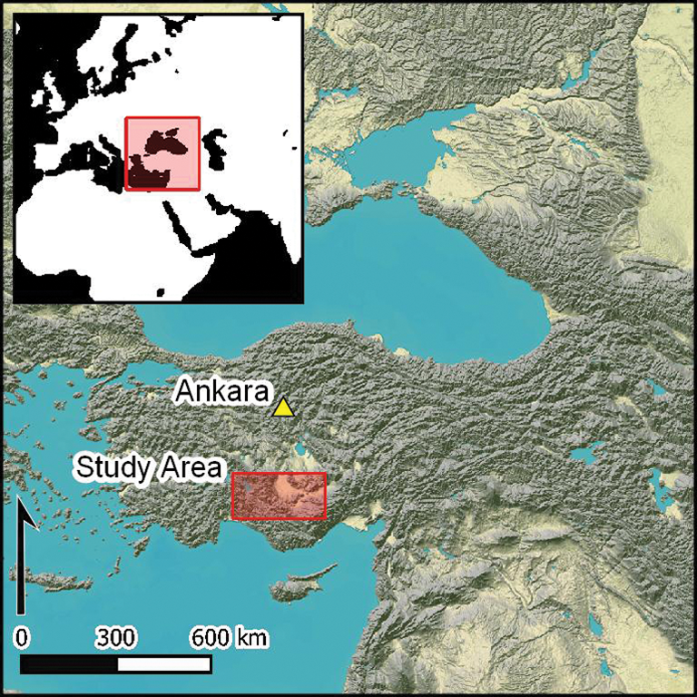
Research on Turkey's Konya Plain is providing fresh insights into the social, economic and cultural dynamics of the earliest farming communities to develop beyond the Fertile Crescent. Central to these debates is Çatalhöyük East, one of the settlement mounds under long-term investigation on the Çarşamba River alluvial fan (Figure 1), which, during the seventh millennium BC, developed into one of the largest Neolithic settlements of South-west Asia.
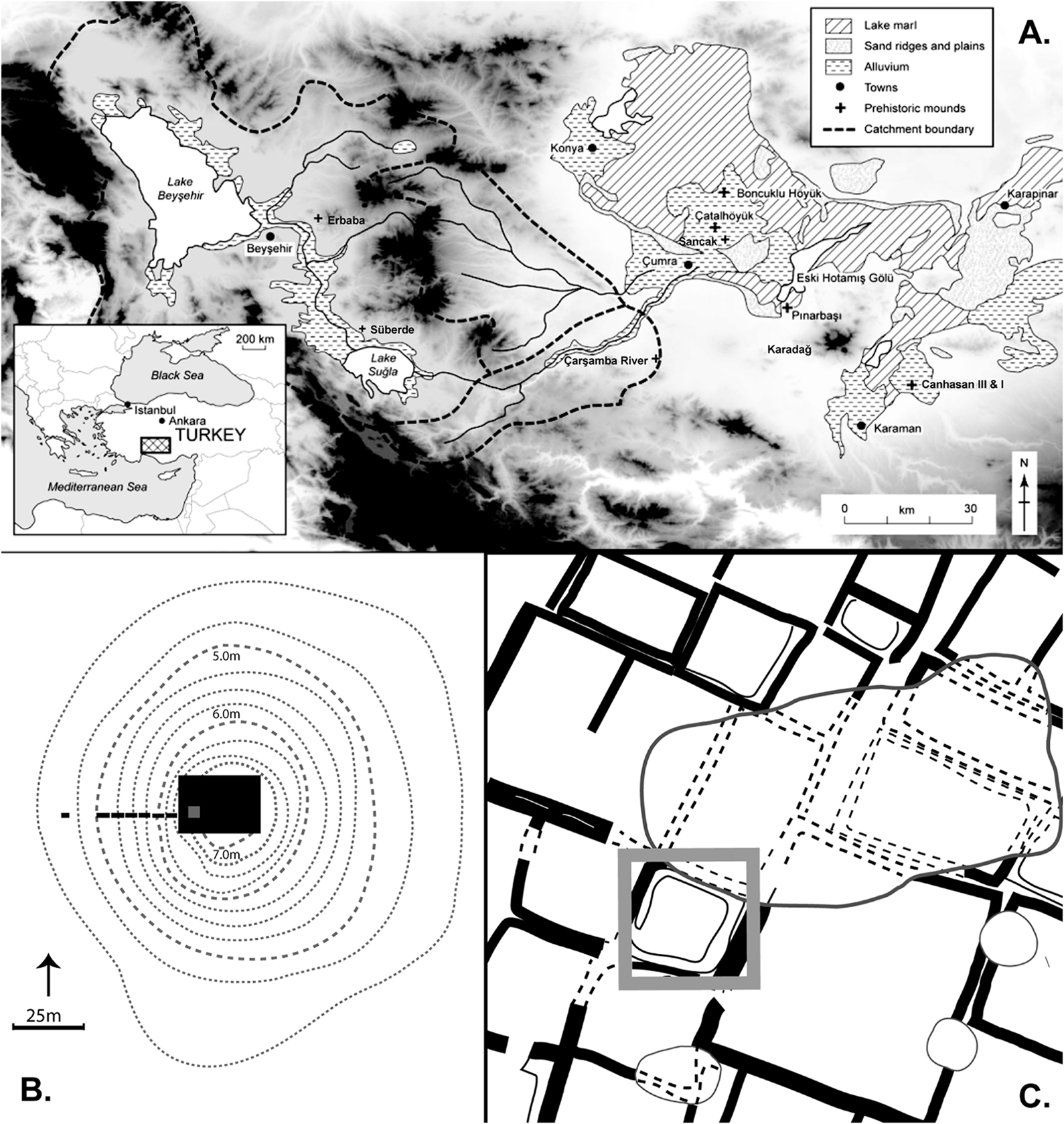
Figure 1. Key locations: A) Konya Plain; B–C) plan of Canhasan III and the excavated area (black) showing the location of the deep sounding (grey), building outlines and areas of disturbance (C, dashed lines) (after French Reference French and Higgs1972).
Ongoing archaeological research is providing an understanding of the context of Çatalhöyük East's emergence and decline. Occupation is known from the Epipalaeolithic at Pınarbaşı (Figure 1), potentially interrupted by the Younger Dryas (Baird et al. Reference Baird2013; Roberts et al. Reference Roberts2016). A dispersed settlement pattern was established in the Aceramic Neolithic (ninth and eighth millennia BC) (Baird Reference Baird and Hodder2006), including the long-lived sedentary forager settlement at Pınarbaşı and the transitional forager-farmer site of Boncuklu (Baird et al. Reference Baird, Fairbairn, Martin, Middleton, Özdoğan and Başgelen2012; Fairbairn et al. Reference Fairbairn, Jenkins, Baird and Jacobsen2014; Baird et al. Reference Baird2018). This dispersed settlement pattern disappeared at the end of the eighth millennium BC, leaving Çatalhöyük East as the sole major settlement in the Çarşamba region through much of the seventh millennium (Baird Reference Baird and Hodder2006). By the early sixth millennium BC, occupation at Çatalhöyük had moved to its West Mound, forming part of a dispersed Chalcolithic settlement pattern (Baird Reference Baird and Hodder2006; Marciniak et al. Reference Marciniak, Barański, Bayliss, Czerniak, Goslar, Southon and Taylor2015; Orton et al. Reference Orton, Anvari, Gibson, Last, Bogaard, Rosenstock and Biehl2018).
Investigation of the two Çatalhöyük settlement mounds has tracked the long-term transformation of these early villages in the context of population and climate changes (Marcianak et al. Reference Marciniak, Barański, Bayliss, Czerniak, Goslar, Southon and Taylor2015; Bogaard et al. Reference Bogaard, Filipović, Fairbairn, Green, Stroud, Fuller and Charles2017), including over a period of climatic cooling and drying at 8.2 ka BP, the effects of which are contested (Roffet-Salque et al. Reference Roffet-Salque, Marciniak, Valdes, Pawłowska, Pyzel, Czerniak, Krüger, Roberts, Pitter and Evershed2018; Wainwright & Ayala Reference Wainwright and Ayala2019). The development of robust radiocarbon chronologies has been central to improving our understanding of the Konya Plain's Neolithic settlement history—particularly for Çatalhöyük, whose re-dating overcame significant problems of residuality, contamination and the old wood effect in the original dating sequence (Bayliss et al. Reference Bayliss, Brock, Farid, Hodder, Southon and Taylor2015; Marciniak et al. Reference Marciniak, Barański, Bayliss, Czerniak, Goslar, Southon and Taylor2015). Less well understood is the history of Neolithic and Chalcolithic occupation at Canhasan sites III and I, located around 60km to the south-east of Çatalhöyük on the Karaman alluvial fan (Figure 1; French Reference French and Higgs1972, Reference French1998). Although they share similarities in material culture with sites of the Çarşamba region, uncertainties about the Canhasan sites’ chronology have limited comparison of their settlement histories. Here, we present new research that refines the chronology of the Canhasan sites, clarifying their relationship with sites to the north-west.
Canhasan III
Canhasan III was excavated in 1969–1970 by David French (Reference French and Higgs1972). A 20 × 30m trench was located towards the centre of the site, covering approximately 6 per cent of its total area (Figure 1B). Excavation sought to understand the site layout and was halted when it encountered the first (most recent) level of building remains. Only in Square 49L—the deep sounding shown in Figure 1C—did excavation extend below these uppermost strata, indicating continuous deposition to a depth of approximately 6.75m, the lowest 2.50m being explored by coring (Figure 2). In 2015, French (pers. comm.) subdivided the deep sounding deposits into nine stratigraphic units: Layers 1–3 comprised deposits above the floors of structures uncovered across the excavated trench, and Layers 4–9 consisted of a series of floors, fills and middens. While the site section (Figure 2, dashed boxes) indicates features consistent with disturbance by burrowing animals, and shows that Layer 3's floors sealed the earlier deposits, the data are otherwise insufficient to determine the contextual integrity of the sequence.

Figure 2. Section of the deep sounding at Canhasan III, with the radiocarbon determinations aligned by layer (95.4% HPD areas; re-drawn from French Reference French and Higgs1972).
Canhasan III was assigned to the Aceramic Neolithic based on an absence of pottery and the presence of distinctive lithics, including large round scrapers, percussion blades and Canhasan Points reminiscent of Amuq Points of the Levantine Pre-Pottery Neolithic B. Hacettepe University (Ergin Reference Ergin1979) and the British Museum (Burleigh et al. Reference Burleigh, Matthews and Ambers1982; Bowman et al. Reference Bowman, Ambers and Leese1990) produced 16 conventional radiocarbon determinations on unidentified wood charcoal. These were later complemented by two AMS determinations on crop seeds (Gillespie et al. Reference Gillespie, Gowlett, Hall, Hedges and Perry1985: 243–44). Two dates were recent, the others spanning from 7749–7521 cal BC (HU-11; 95.4 per cent probability) to 7055–6427 cal BC (HU-10; 95.4 per cent probability). Twelve dates support an Aceramic Neolithic date of before 7000 cal BC, which marks the beginning of the Ceramic Neolithic at Çatalhöyük (Bayliss et al. Reference Bayliss, Brock, Farid, Hodder, Southon and Taylor2015). Samples HU-9, HU-10, OxA-388 and BM-1655 suggest that occupation at Canhasan III extended beyond 7000 cal BC (for details of all these dates, see Table S1 in the online supplementary material (OSM)). These dates, however, do not follow the stratigraphy, with the most recent date (OxA-388) coming from the deepest layer. At the time, this was believed to be the result of the other determinations suffering from an old wood effect, in which dated samples came from long-lived timbers and did not reflect the date of their incorporation into the archaeological record (Gillespie et al. Reference Gillespie, Gowlett, Hall, Hedges and Perry1985). A further problem with all published dates was uncertainty in phasing—only clarified by French (pers. comm.) in 2015—which made the establishment of reliable dating sequences impossible.
Taken at face value, the original radiocarbon determinations suggest that Canhasan III pre-dates Çatalhöyük East, whose earliest excavated levels are dated to c. 7100 cal BC (Bayliss et al. Reference Bayliss, Brock, Farid, Hodder, Southon and Taylor2015), but that Canhasan III's occupation extended into the time of Çatalhöyük East's earlier phases of occupation—possibly as late as Levels South L–O (Farid Reference Farid and Hodder2013; Mellaart Levels VI–VIII; c. 6800–6400 cal BC), when elaborate symbolism and population peaked. Canhasan's presumed continued occupation sits uncomfortably with the archaeological evidence: no pottery was excavated at Canhasan III, although it appears at Çatalhöyük East c. 7000 BC (Bayliss et al. Reference Bayliss, Brock, Farid, Hodder, Southon and Taylor2015). Furthermore, Canhasan's architecture is more consistent with that of mid eighth-millennium Aşıklı Höyük in Cappadocia than with elaborate buildings at Çatalhöyük East. Lastly, both Byblos and Canhasan/Musular Points are recorded among Canhasan III's lithic assemblage; yet these disappear from Çatalhöyük after 7000 cal BC (Carter et al. Reference Carter, Conolly, Spasojević and Hodder2005).
Canhasan I
French (Reference French1998) interpreted the results of the 1961–1967 excavations on the 8ha mound of Canhasan I as showing seven consecutive layers, each consisting of one or more occupation levels. Layers 1–4 were assigned to the Late, Middle and Early Chalcolithic, and comprised well-defined mud-brick buildings on stone foundations, including two-storey structures similar to those at Çatalhöyük West. Layers 5–7 were excavated only in a small area, with excavation halting at the water table. Assigned to the Late Neolithic through ceramic typology, the deepest coherent structural remains were found in Layer 5, with further deposits thought to be present below Layer 7.
The original radiocarbon chronology for Canhasan I was derived from unidentified wood charcoals (Table S2) taken from Early Chalcolithic Layers 2A and 2B, from the collapse of a burnt roof in the east and west rooms of Building 3 in Layer 2B (also known as Structure 3 or House 3) (see Stuckenrath & Ralph Reference Stuckenrath and Ralph1965; Barker & Mackey Reference Barker and Mackey1968; French Reference French1998: 31–34). Layer 2B's calibrated age ranges span a wide period of c. 6500–5000 cal BC, reflecting the individual error terms and calibration ranges (Table S2). No information is available for the source of the single determination from Layer 2A (P789), which calibrates to 6005–5725 cal BC (95.4 per cent probability). The date of Layer 2A seems older than several dates from Layer 2B, which is stratigraphically earlier than 2A, suggesting an old wood effect or the presence of residual material. This may also explain the two Layer 2B wiggle-match dates recorded by Thissen (Reference Thissen, Gerard and Thissen2002; see Table S2), the older of which is 1080–795 years older than the most recent of the radiocarbon determinations (compare P-792 and AA-41171). This is unsurprising, as combinations of old wood effects and timber recycling are suspected to have introduced offsets of similar scales elsewhere in South-west Asia (Wicks et al. Reference Wicks, Finlayson, Maričević, Smith, Jenkins and Mithen2016). Combined with an absence of radiocarbon dates from Layers 3–7, uncertainty about the chronology of Layer 2 has hampered an understanding of Canhasan I's place in the regional settlement sequence.
Revising the chronologies at Canhasan III
French's 2015 (pers. comm.) full stratigraphic sequence for Canhasan III identified nine layers (Layer 1 being the latest, see Figure 2), from which 30 specimens were submitted for radiocarbon dating. With one exception, all new samples were either single cereal grains or nutshell fragments (see Table S3). The samples were pre-treated and measured at the Australian Nuclear Science and Technology Organisation (ANSTO) and the Waikato Radiocarbon Laboratory using protocols described in the OSM, resulting in 26 successful determinations (Table 1A).
Table 1. New AMS radiocarbon results from Canhasan (calibration using OxCal 4.2 and IntCal 13 calibration curve; Bronk Ramsey Reference Bronk Ramsey2009b; Reimer et al. Reference Reimer2013).

Excluding the five intrusive Ottoman samples, the new dates range from 7520–7185 cal BC (OZT-758; 95.4 per cent probability) to 7075–6700 cal BC (OZT-757; 95.4 per cent probability), although a high degree of contextual uncertainty complicates interpretation. As with the earlier radiocarbon results, the new determinations did not match the expectations based on stratigraphic position, indicating considerable mixing in the profile. With one exception (WK-41921), datable specimens from secure in situ contexts, such as hearths, were not available and burnt in situ storage contexts were absent from the excavated area. All other specimens came from site fills or structural elements of houses, such as plaster floors and mud-brick walls. These elements contained specimens perhaps deriving from quarried sediment used as building material, and thus have a high probability of being residual. Ideally, more secure contexts would have been sampled, but this is often impossible when dealing with archive material from old excavations.
The uncertainties introduced by the sampling could, in principle, be addressed by using outlier models (Bronk Ramsey Reference Bronk Ramsey2009a). There is, however, insufficient information to select an appropriate prior distribution. Hence, all resulting formal models based on Bayesian methods either fail to fit the data or would include arbitrary parameters that could produce misleading results. Consequently, we follow a different strategy, using the distribution of dates and a kernel density estimate (KDE) to address the question of whether Canhasan III persisted into the Ceramic Neolithic. Although the material culture does not support such a hypothesis, the question shifts to whether the available radiocarbon determinations might support it. The shape of the calibration curve helps resolve this problem. The transition to the Ceramic Neolithic took place sometime around a steep section of the calibration curve—c. 7050 cal BC (see Figure 3); if Canhasan III did persist beyond 7000 cal BC, we would expect to see reliable determinations calibrating beyond this steep section of the curve.

Figure 3. Effects of the break in the calibration curve around 7050 cal BC (figure by P. Jacobsson).
The five Ottoman-period determinations aside, the total of the new and legacy determinations comes to 38 radiocarbon dates for Canhasan III (Figure 4; Tables S1 & S3), although insufficient technical documentation precludes use of the four Hacettepe (Ergin Reference Ergin1979) dates. Of the 34 remaining determinations, only three, BM-1655 (from Layer 2), OZT-757 (from Layer 6) and OxA-388 (from Layer 8), have radiocarbon ages younger than c. 8050 BP, which corresponds to the steep section of the calibration curve at 7050 cal BC (Figure 3). These three determinations are therefore the only indicators of Ceramic Neolithic activity at Canhasan III. Two of them, however, suffer from obvious problems:
• BM-1655 from a bulk charcoal sample: two Ottoman seeds in this layer (Wk-40642 and Wk-40638) indicate that the sample may have contained intrusive material and, hence, is too young.
• Sample OZT-757 produced 0.08mg of graphite, which makes the sample more susceptible to contamination.

Figure 4. Calibrated date ranges from Canhasan III using OxCal v4.3.2 (Bronk Ramsey Reference Bronk Ramsey2017) and IntCal13 (Reimer et al. Reference Reimer2013); the vertical line indicates 7050 cal BC (figure by P. Jacobsson).
This leaves OxA-388, the youngest of the Neolithic samples, to suggest activity in the Ceramic Neolithic. This sample seems to be a statistical outlier, given that its 99.7 per cent range (7505–6360 cal BC) stretches to before the introduction of pottery, considering the size of the dataset (35 radiocarbon determinations). To contradict this, we would have to assert that the 26 older samples from the layers above OxA-388 suffer from residual and old wood effects counted in multiple centuries.
A KDE (Bronk Ramsey Reference Bronk Ramsey2017) of the Canhasan III distribution supports our view that its dates fall before 7050 cal BC. KDE can provide robust estimates of when a group of radiocarbon samples formed (Bronk Ramsey Reference Bronk Ramsey2017). While not providing start/end dates for archaeological activity, the approach is sufficient to indicate whether, had more samples been available, we could expect to find material post-dating 7050 cal BC. The British Museum samples were omitted from the analysis, as KDE cannot account for old wood effects without modelling. The estimate places the formation of the dated, short-lived materials at Canhasan III (excluding OZT-757; Figure 5) at 7565–6960 cal BC (95.4 per cent probability), with only 7.6 per cent of the distribution extending beyond 7050 cal BC. If we exclude OxA-388 as an outlier, this value drops to 1.8 per cent. While the interpretation of these results is not as straightforward as a meaningful Bayesian chronological model of the Sheffield type, KDE does imply that the short-lived samples from Canhasan III died before 7050 cal BC, and thus that the site was abandoned before the end of the eighth millennium BC.

Figure 5. Kernel density estimate summarising the Canhasan III calibrated date ranges (figure by P. Jacobsson).
The question of when Canhasan III was founded is more complex, as the basal layers in the trenches were not reached, and the excavation covered only approximately 6 per cent of the mound area (French Reference French and Higgs1972). Furthermore, the complex and unknown depositional history of the available samples means that trying to extrapolate any information using an age-depth model (e.g. Blaauw Reference Blaauw2010) risks introducing unknowable biases. KDE suggests that the dated samples derive from depositions that took place sometime after 7500 cal BC. When considered alongside the extent of overlap between the available dates, it seems that a rather short period of deposition is involved. If this rapid deposition rate also applied to the earlier part of the site's history, it is possible that settlement at Canhasan III began as part of the mid to late eighth-millennium cultural transformations on the Konya Plain (Baird Reference Baird and Hodder2006).
Storage deposits from Canhasan I
Charred pea and barley seeds were available for new AMS dates from three in situ burnt crop stores found in grain bins in a well-preserved building within Square R21b (French Reference French1998: 22–24) (Table S4). Unlike the samples from Canhasan III, these specimens were from a primary-use location, providing a secure terminus post quem and terminus ante quem for the deposits immediately above and below. The sequence in Square R21b was one of the deepest at the site, with Layer 5 clearly separated from Layer 2B, from which the legacy radiocarbon determinations came, by two phases of house construction and infilling (Layers 3–4), totalling approximately 2m in depth of sediment (French Reference French1998: 73–75, figs 41–43). Structure 3, also in Layer 2B, was not excavated in that trench but 15–20m away in Square R23, to which it was connected through the stratigraphic section (French Reference French1998: figs 33–34). Thus, there is clear stratigraphic separation of the two layers for which dates are available, which are also distinguished by their material culture and architecture as Late Neolithic (Layer 5) and Early to Middle Chalcolithic (Layer 2B). This permits the construction of a chronological model describing the dates and the relationship between the Late Neolithic and Early to Middle Chalcolithic at Canhasan I.
New radiocarbon determinations on the seeds from the Layer 5 storage deposits (Table 1B) were used along with the legacy determinations to build a model (Figure 6; using OxCal 4.3 and IntCal 13 calibration curve; Bronk Ramsey Reference Bronk Ramsey2009b; Reimer et al. Reference Reimer2013). The model consists of two consecutive phases (Can I Level 5 Phase and Can I Level 2 Phase) representing the Late Neolithic and Chalcolithic occupations. Both phases are bounded, as the deposition rates between the two layers may have differed. The Layer 2 samples are also subject to an old wood outlier model (Bronk Ramsey Reference Bronk Ramsey2009a) using default priors and parameter names (“Outlier_Model charcoal”, Exp(-10, 0, 1), U(0,3), “t”). Sample P793 is not included in the model, as it was identified in the original datelist as too small for a reliable determination (Stuckenrath & Ralph Reference Stuckenrath and Ralph1965: 193). Furthermore, as it appears that they are much older than the formation of Layer 2, the two wiggle-match dated timbers are treated as termini post quem in the model. This is justified given the longevity of juniper. To summarise, the boundaries of Layer 5 define the period of use of the Layer 5 cereal storage bins, and the boundaries of Layer 2 mark the plausible dates of deposition of the Chalcolithic material.

Figure 6. Model outline for Canhasan I; the wiggle-match dates on timbers from tree 1 and tree 2 are treated as ordered bound sequences due to the lack of ring-counting data (figure by P. Jacobsson).
The model results (Figure 7) indicate that activity at Canhasan I Layer 5 (Can I Level 5 Onset Boundary) dates to 6080–5915 cal BC (95.4 per cent probability), with the 68.2 per cent high-probability density (HPD) area split into two modes at 6020–5980 cal BC (32.4 per cent probability) and 5965–5925 cal BC (35.8 per cent probability). The estimate for the end of activity at Canhasan I Layer 5 (Can I Level 5 End Boundary) dates to 5995–5840 cal BC (95.4 per cent probability), with the 68.2 per cent HPD area split into two modes at 5985–5970 cal BC (8.6 per cent probability) and 5945–5890 cal BC (59.6 per cent probability). The bimodality of the 68.2 per cent probability estimates is driven by the wiggle in the calibration curve between 6000 and 5950 cal BC. With such a small sample, it is probable that the onset in Layer 5 was earlier than suggested by the estimate; similarly, the end of activity could have been later. The estimate for the onset of activity at Canhasan I Layer 2 (Can I Level 2 Onset Boundary) dates to 5950–5635 cal BC (95.4 per cent probability), with the 68.2 per cent HPD area in 5910–5635 cal BC. The estimate for the end of activity at Canhasan I Layer 2 (Can I Level 2 End Boundary) dates to 5760–5455 cal BC (95.4 per cent probability), with the 68.2 per cent HPD area in 5705–5570 cal BC.
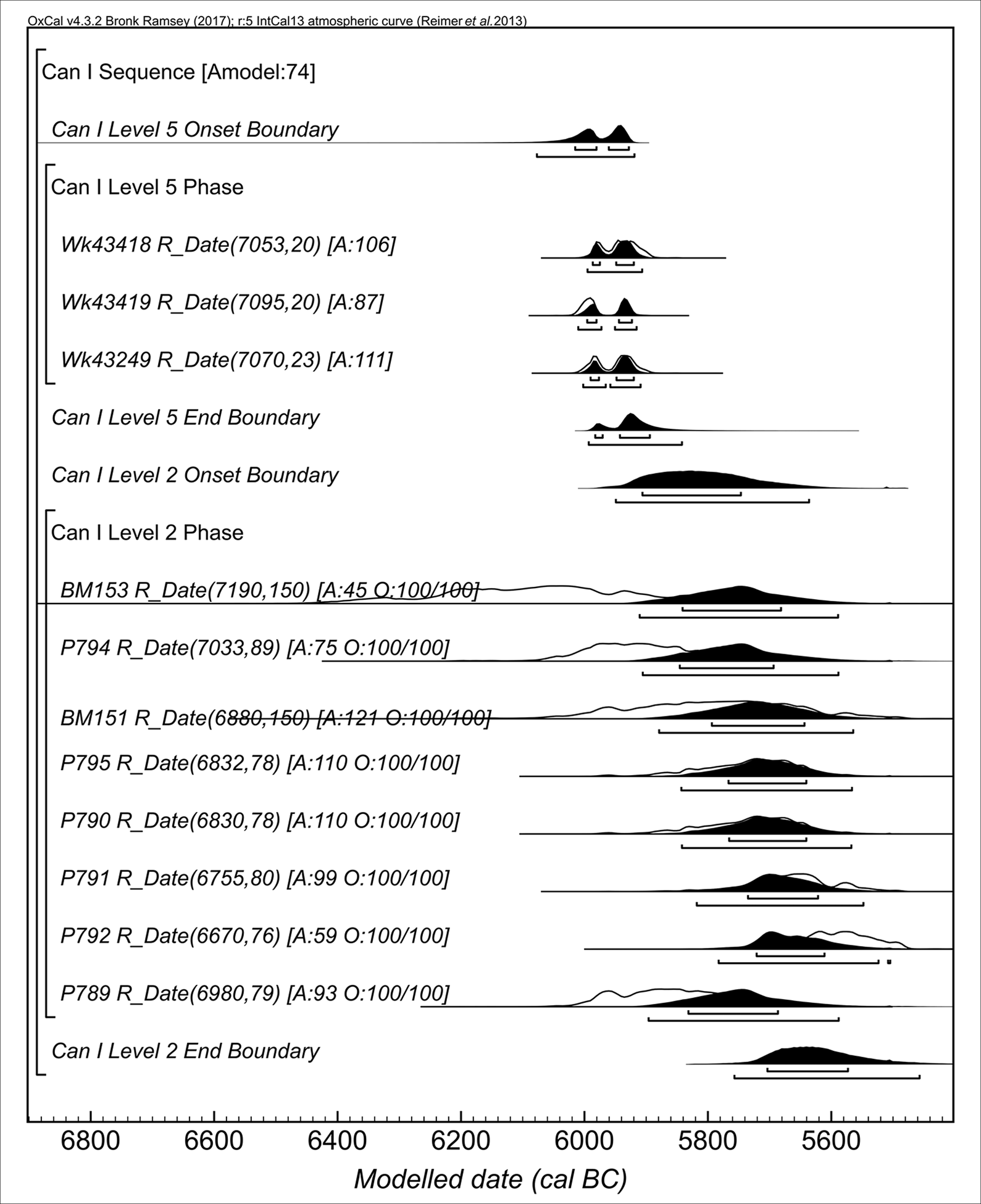
Figure 7. Model results for Canhasan I, using OxCal v4.3.2 (Bronk Ramsey Reference Bronk Ramsey2017) and IntCal13 (Reimer et al. Reference Reimer2013) (boundaries on the wiggle-match estimates (tree 1 sequence and tree 2 sequence) not shown) (figure by P. Jacobsson).
A revised settlement sequence for Canhasan
A key problem with Canhasan III's original chronology was understanding whether its occupation extended into the Ceramic Neolithic, which was dated at Çatalhöyük East to 7030–6910 cal BC (95.4 per cent probability; Bayliss et al. Reference Bayliss, Brock, Farid, Hodder, Southon and Taylor2015). Archaeological evidence and the KDE of new radiocarbon dates on short-lived material disprove this. It is less clear whether there was any overlap between Canhasan III and the Aceramic Neolithic settlement at Çatalhöyük East. The latter has been modelled to 7165–7085 cal BC (95.4 per cent probability), or 7290–7080 cal BC (95.4 per cent probability) allowing for the differential rate of deposition in the site's lower levels, within the deep sounding (Bayliss et al. Reference Bayliss, Brock, Farid, Hodder, Southon and Taylor2015). These boundaries overlap with the 95.4 per cent calibrated date ranges of 22 of the Canhasan III radiocarbon determinations, and the KDE for the whole group (Figure 8a). While this evidence is not as decisive as a difference between boundaries of a Bayesian model, it is very plausible that seeds were being deposited at Canhasan III at the time that the settlement at Çatalhöyük East was beginning (Figure 8b), indicating synchronicity in occupation of the two sites at the end of the eighth millennium cal BC.
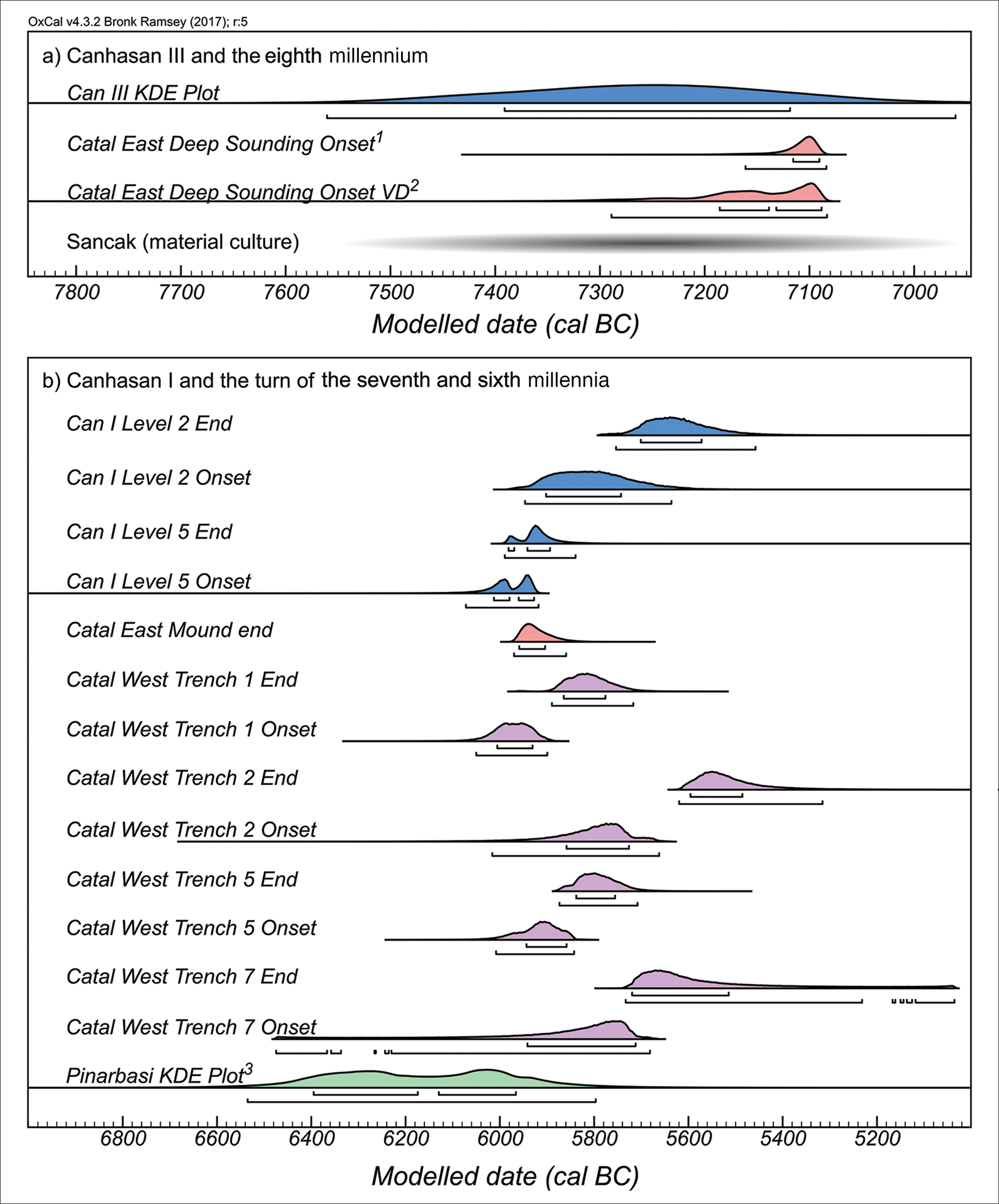
Figure 8. Revised Early Holocene settlement sequence for the western Konya Plain (1 and 2 refer to the alternative models for the onset of activity in Çatalhöyük (Bayliss et al. Reference Bayliss, Brock, Farid, Hodder, Southon and Taylor2015; Bronk Ramsey Reference Bronk Ramsey2017)) (3 based on dates in Watkins (Reference Watkins and Hodder1996)) (figure by P. Jacobsson).
Canhasan I's new Layer 5 dates provide convincing evidence of its contemporaneity with early occupation at Çatalhöyük West (Figure 8b; Orton et al. Reference Orton, Anvari, Gibson, Last, Bogaard, Rosenstock and Biehl2018: 629–30). The onset of activity at Canhasan I Layer 5 (Can I Level 5 Onset Boundary) also precedes the terminal phases of occupation at Çatalhöyük East, which are modelled to 5975–5865 cal BC (Marciniak et al. Reference Marciniak, Barański, Bayliss, Czerniak, Goslar, Southon and Taylor2015) with 89.5 per cent probability. This does not take into account undated deposits below Canhasan Layer 5, which form part of a sequence of five buildings built sequentially over each other in Layers 7–4 (French Reference French1998: fig. 43)—a pattern mirrored at Çatalhöyük East, and with which the buildings share architectural similarities. These buildings were above another approximately 1m of unexcavated deposit that perhaps preserved one or two more building layers, potentially adding 20–260 years to the age estimate for Layer 5 (using the 5- to 65-year estimate range for the duration of the later building levels at Çatalhöyük East; Cessford Reference Cessford and Hodder2005). Although this estimation is coarse, it suggests that occupation is unlikely to have begun much earlier than c. 6200 cal BC, a date that fits the lithic and ceramic evidence well (Figure 9). Pressure blades, well represented in Canhasan I Layers 7–4 (Ataman Reference Ataman1988: 242), only become common at Çatalhöyük East from 6400 cal BC onwards (Carter & Milić Reference Carter, Milić, Borrell, Ibáñez and Molist2013). Published research clearly indicates a significant presence of carinated and S-profiled jars and bowls in Layers 7–4 (French Reference French2005: 118–29). These forms comprise 18–25 per cent of the ceramic assemblages in Çatalhöyük East's late occupation levels (Özdöl-Kutlu et al. Reference Özdöl-Kutlu, Carter, Czerniak, Marciniak, Hodder and Marciniak2015). Furthermore, Çatalhöyük East's collared jars and bowls, which are characteristic of its later occupation levels (Yalman et al. Reference Yalman, Özbudak, Gültekin and Hodder2013), also resemble some carinated shapes at Canhasan I.
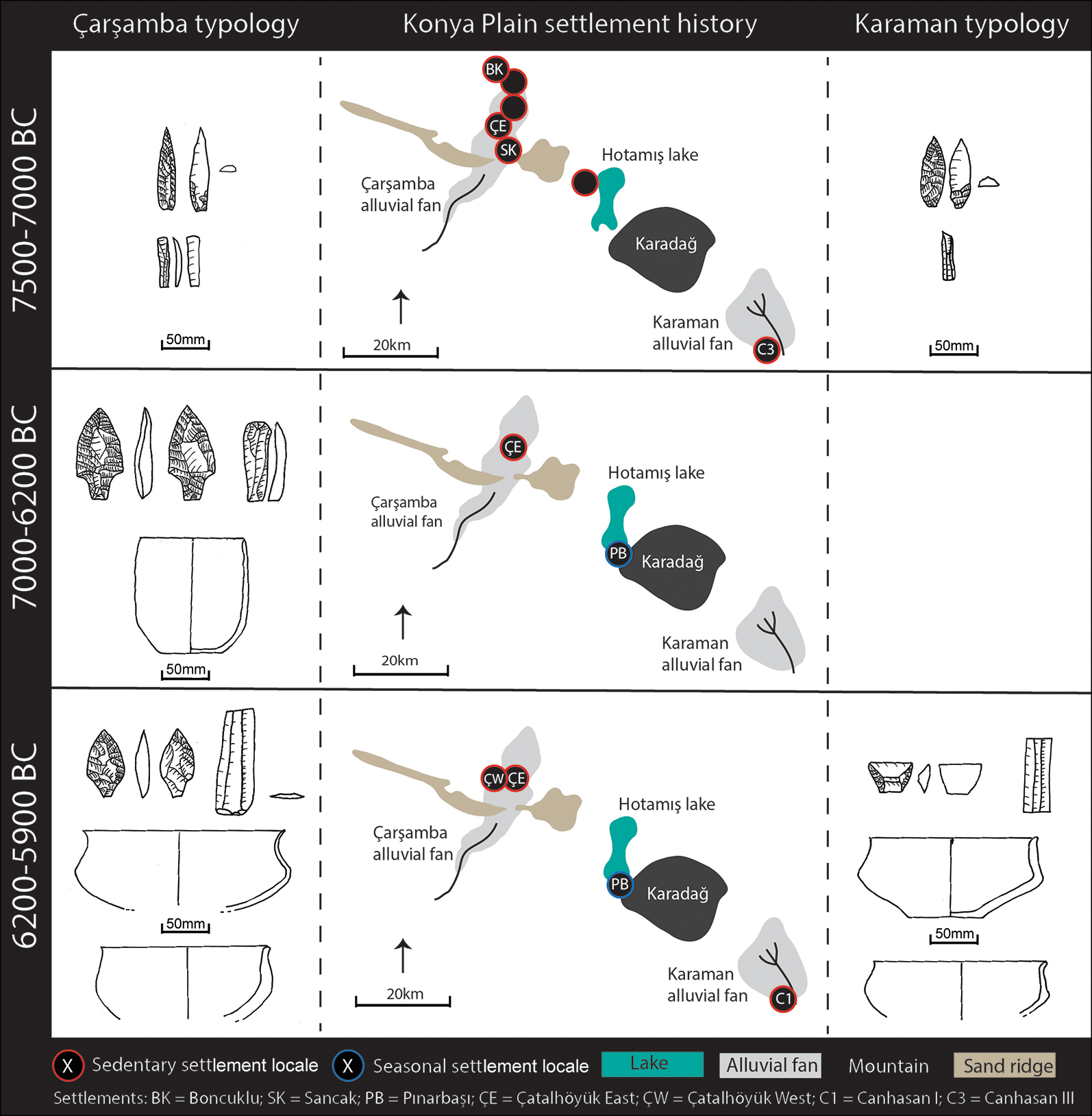
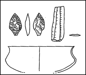
Figure 9. Settlement distributions and chronologically diagnostic artefact types 7500–5900 cal BC in the western Konya Plain (artefacts redrawn from Ataman 1988; Baird Reference Baird, Bolger and Maguire2010; Yalaman et al. Reference Yalman, Özbudak, Gültekin and Hodder2013; Özdöl-Kutlu et al. Reference Özdöl-Kutlu, Carter, Czerniak, Marciniak, Hodder and Marciniak2015) (figure by D. Baird and A. Fairbairn).
Discussion
KDEs concur with artefactual typology, suggesting that settlement at Canhasan III pre-dated 7050 cal BC, perhaps originating in the mid to late eighth millennium BC, and that the locale was then abandoned until the late seventh millennium, when Canhasan I was occupied for the first time. Thus, Canhasan I was a resettlement of the Karaman alluvial fan, rather than representing local continuity through relocation from Canhasan III. This is in line with earlier questions concerning settlement persistence based on discontinuities in lithic traditions (e.g. Ataman Reference Ataman1988: 241–42). This evidence radically changes our understanding of the settlement history of the Neolithic and Chalcolithic in the Çarşamba and Karaman alluvial areas.
The Late Aceramic Neolithic abandonment of Canhasan III before 7050 BC is consistent with a pattern of settlement reorganisation on the Çarşamba fan, when small, dispersed sites such as Boncuklu and Sancak disappeared, leaving Çatalhöyük East as the only settlement on the western Konya Plain (Figure 9; Baird Reference Baird and Hodder2006, Reference Baird, Bolger and Maguire2010). The removal of the only other contemporaneous sedentary settlement from this region accentuated Çatalhöyük's isolation between 7000 and 6200 BC, leaving Suberde, Erbaba and other sites 100km to the west in the Suğla and Beyşehir basins as its only known regional contemporaries (Figure 1A). Whether this focus at one settlement was due to the deliberate aggregation of communities that were previously socially and culturally connected but physically dispersed, or to other factors such as an aggressive territorial takeover, is unclear (see Baird Reference Baird and Potts2012). Given the absence of archaeological evidence for violence and destruction, combined with strong cultural continuities between settlements, the former seems most plausible. Aceramic Neolithic settlements on the Çarşamba alluvial fan are thought to have been part of a mutually supportive social network, perhaps linked by exogamous partner exchange (Baird Reference Baird and Hodder2006, Reference Baird, Bolger and Maguire2010). It is also unclear whether aggregation at Çatalhöyük East was the result of internal social dynamics or a response to external threat—although neither are obvious in the regional archaeological record. If the abandonment of Canhasan III was part of this phenomenon, it would imply that Çatalhöyük East's Ceramic Neolithic community derived from an extensive territory; the amalgamation of communities up to 70km apart perhaps underlies evidence for extensive use of the landscape (e.g. Fairbairn Reference Fairbairn2005; Roberts & Rosen Reference Roberts and Rosen2009; Hodder Reference Hodder and Hodder2014).
The late seventh-millennium resettlement of Canhasan prefigures a second, broad phase of Early Chalcolithic settlement reorganisation and the end of Çatalhöyük East's exclusivity as the major settlement on the western Konya Plain (Baird Reference Baird and Hodder2006). Evidence from the Pınarbaşı rockshelter, for example, shows its reuse as a seasonal base for herders and hunters by c. 6400 cal BC (Baird et al. Reference Baird, Carruthers, Fairbairn and Pearson2011). Simultaneously, following its demographic and symbolic zenith, Çatalhöyük East experienced a reduction in population, along with a reorientation of its tightly knit community into household-focused social groupings (Marcianak et al. Reference Marciniak, Barański, Bayliss, Czerniak, Goslar, Southon and Taylor2015). Evidence also points to a restructuring of Çatalhöyük East's population into settlements on the East and West mounds c. 6000 BC—an event seemingly bridged by early occupation at Canhasan I. At Çatalhöyük East, this restructuring trend eventually resulted in settlement only on the West Mound (Orton et al. Reference Orton, Anvari, Gibson, Last, Bogaard, Rosenstock and Biehl2018).
Surveys identify a broad pattern of Early Chalcolithic settlement dispersal across a wide range of locations, indicating new ways of using the landscape (Baird Reference Baird and Potts2012). It is worth considering whether the 8.2k BP climate event, in which cool and dry conditions persisted, may have influenced settlement changes. Although the precise effects of the 8.2k BP event on the Konya Basin are contested (Roffet-Salque et al. Reference Roffet-Salque, Marciniak, Valdes, Pawłowska, Pyzel, Czerniak, Krüger, Roberts, Pitter and Evershed2018; Wainwright & Ayala Reference Wainwright and Ayala2019), it is unlikely to have triggered the wide dispersal of settlement in the Early Chalcolithic that took place 300–500 years after the 8.2k BP event (Baird Reference Baird and Potts2012). It is more difficult to resolve how the event influenced the reconfiguration of Çatalhöyük—particularly its reduction in size and density of occupation—and the resettlement of the Canhasan area. Given that changes in the arrangement of Çatalhöyük's settlement began centuries before 8.2k BP, we could question the event's causal role at all.
The close cultural affinities between contemporaneous settlements at Canhasan I, late Çatalhöyük East and Çatalhöyük West suggest strong ties between them, and even the possibility that Canhasan was resettled by people from Çatalhöyük. Caveats must, however, be expressed about the quality of settlement data underpinning interpretations for the Karaman region, as it has not been surveyed using the relatively intensive methods applied in the north-west (Baird Reference Baird and Hodder2006); there may well be other undiscovered Neolithic settlements. Nevertheless, it seems an unlikely coincidence that people with identical material culture and very similar architectural styles as at Çatalhöyük reoccupied Canhasan at the same time as the Çatalhöyük East community was reducing in size and restructuring its settlement. An alternative to environmental attraction or happenstance for the resettlement of the Canhasan locale is that the association of Çatalhöyük's people with its ancestral landscape, inherited from the Aceramic Neolithic settlement pattern, was maintained through the seventh millennium, perhaps through regular visits for hunting or other activities. Although only verifiable with new excavations at Canhasan and DNA analyses, the evidence from the western Konya Plain suggests not only occupation over a wide territory by its Neolithic population, but also hints at extended regional continuity, irrespective of residential locale.
Acknowledgements
We offer this article in memory of David French, a respected colleague and archaeological pioneer. This research is part of a project coordinated by Douglas Baird to complete outstanding publications on the Canhasan sites, and was supported by the Australian Institute of Nuclear Science and Engineering, the Australian Research Council (FT130101702), the University of Queensland School of Social Science and the British Institute at Ankara.
Supplementary material
To view supplementary material for this article, please visit https://doi.org/10.15184/aqy.2020.13


