


Introduction
Most English place-names fall into two categories: habitative names which describe aspects of the built or cultural environment (settlements, buildings, enclosures, etc.) and topographical names which describe the physical landscape or types of land use (hills, valleys, woodland, etc.) (Gelling, Reference Gelling1984; Cameron, Reference Cameron1988: 27–32; Gelling & Cole, Reference Gelling and Cole2000). Among the latter, names indicating what must have been, to place-namers, significant local characteristics of rivers, minor watercourses, and wet ground are common. Across the country, nearly 2000 major settlement-names contain some reference to river forms and flowing water. Linguistically, the great majority of these names are either Old English or Old Norse in origin (Gelling, Reference Gelling1978: 19–29). Their creation can, thus, be dated to the period when these languages were spoken in England. For Old English, that is (roughly) from the fifth to the eleventh century ad, and for Old Norse, from the ninth to the eleventh. Further chronological precision for certain individual names is provided by attestations in written sources which offer a terminus ante quem for their existence. In an otherwise relatively poorly documented period, water-related place-names represent one of the most closely observed, and most extensive, repositories of material informing directly on the physical character of early medieval rivers, their hydrologic regimes, and their floodplains. The value of these names for understanding fluvial processes in the past is enhanced by the richness and variety of the descriptive vocabulary they contain, the possible precision with which particular terms were applied, and the locational tenacity they exhibit across time.
In this article, and for the first time, place-names have been used to guide fluvial geoarchaeologists to specific parts of three English rivers in order to examine their depositional and flood histories. Using this new approach, the early medieval toponymic descriptions of certain localized river behaviours can be set against the broadly contemporary evidence of actual fluvial activity as revealed in the sedimentary records of these places. Here one Old English place-name element, *wæsse—a term toponomasts have interpreted as indicating a place prone to flooding—has been targeted. Three places with this descriptive term have been investigated: Broadwas (River Teme, Worcestershire), Buildwas (River Severn, Shropshire), and Rotherwas (River Wye, Herefordshire). Analysis of the sedimentary record of alluvial deposition at these *wæsse-sites, and careful consideration of the magnitude, frequency, and timing of their flood events throws light on key questions relating to when and why *wæsse-settlements may have acquired their names. It also offers greater precision regarding the nature of the fluvial and geomorphological processes witnessed by their place-namers and which they sought to describe through this term. The period investigated lies beyond that covered by historical flood data, which typically starts in the later medieval period (e.g. Macdonald, Reference Macdonald2013) except in the Classical World (Brown, Reference Brown1997). Here we use data from an analysis of overbank levee sedimentation proximal to stable channels as suggested by Jones et al. (Reference Jones, Lewin and Macklin2010) but extend their approach by over 1000 years.
Names in -*wæsse and the Early Medieval Histories of Broadwas, Buildwas, and Rotherwas
The Old English word *wæsse is preserved only in place-names. Even as a naming element it is relatively rare, appearing in just ten settlement-names and a handful of names of lesser status referring to landscape features. Most of these *wæsse-names are found in the West Midlands. This restricted geographical distribution may indicate that, during the early medieval period, the term was exclusive to the Anglian varieties of English spoken in the Midlands and North, and may not have been available to place-namers beyond these linguistic communities (Gelling, Reference Gelling1984: 59–60). All these settlements in -*wæsse are located on significant rivers whose names, without exception, were formed in pre-English languages (Figure 1).
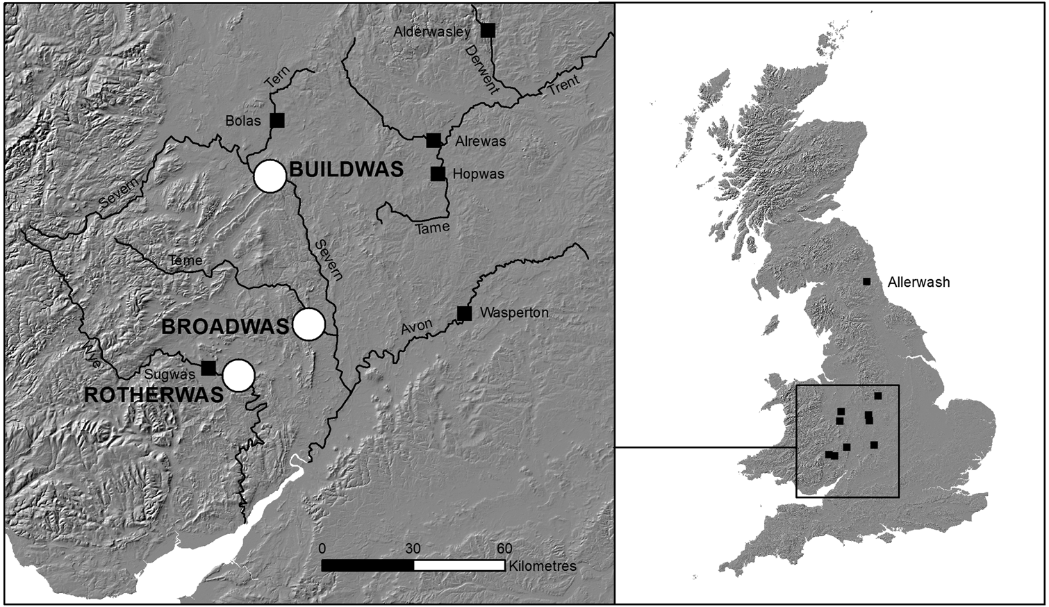
Figure 1. Location of *wæsse place-names.
The term *wæsse is closely related to Old English gewæsc ‘washing, flood’ and wæsce ‘place for washing’ but, because it is not on independent record, its precise meaning must be inferred. Since a low-lying riverine location is shared by all settlements taking this element, a general sense of wetness is fairly secure. Consequently, in early place-name dictionaries, the term was interpreted to mean ‘wet place, swamp, marsh’ (Smith, Reference Smith1956ii: 237–38). In some instances, support for the idea that *wæsse was originally intended to indicate wet ground is found in the terms used to qualify it. For example, Old English alor, the water-loving alder tree, is found in Alderwasley (Derbyshire), Allerwash (Northumberland), and Alrewas (Staffordshire) (Cameron, Reference Cameron1959: 515; Gelling & Cole, Reference Gelling and Cole2000: 64; Horovitz, Reference Horovitz2005: 83–84). Field observations made at Buildwas in the 1970s led Gelling to offer a more precise definition. She witnessed both the inundation of, and subsequent rapid retreat of water from, the floodplain of the River Severn over the space of twenty-four hours. She proposed the more precise meaning ‘land by a meandering river which floods and drains quickly’ (Gelling, Reference Gelling1984: 59–60; Gelling & Cole, Reference Gelling and Cole2000: 63–64). This definition is now widely accepted, although in some publications it is abridged to simply ‘alluvial land’ (Mills, Reference Mills2011).
The earliest secure date for the use of *wæsse is provided by a charter of ad 942 referring to Alrewas (Sawyer, Reference Sawyer1968: Charter 479). A charter purporting to date from ad 789 × 790 for Broadwas is considered a later forgery (Sawyer, Reference Sawyer1968: Charter 126; Hooke, Reference Hooke1990: 87–90), but it is preserved in a manuscript of the late eleventh century. Two charters relating to Wasperton, dated ad 1043 (Sawyer, Reference Sawyer1968: Charters 1000 & 1226; Hooke, Reference Hooke1999: 104–05), are also forgeries, preserved in manuscripts from the thirteenth century and later. It is in Domesday Book (ad 1086) that Buildwas, Hopwas (Staffordshire), Rotherwas, Sugwas (Herefordshire), as well as Wasperton are first attested (Harkins & Rumble, Reference Harkins and Rumble1976: 1,39; Plaister, Reference Plaister1976: 6,18; Thorn & Thorn, Reference Thorn and Thorn1983, 25,1 and 2,37; Thorn & Thorn, Reference Thorn and Thorn1986: 1,7); while the name Bolas (Shropshire) is only found from 1198 and Alderwasley no earlier than 1251 (Watts, Reference Watts2004: 7, 68). While it is entirely possible for these names to have existed long before they were formally recorded, the dates of attestation may suggest that *wæsse belongs to a relatively late stratum of place-naming. But the existence of the names of the three case-study sites examined here is, at least, confirmed by 1086.
As a precursor to the sedimentological analysis that will follow, consideration must first be given to the situation and early histories of the three *wæsse-settlements selected for study. Broadwas stands on the River Teme (Figure 2). The river rises in the Kerry Hills of mid-Wales and drains south-eastwards for approximately 100 km to meet the River Severn just south of Worcester. Its drainage system is such that most of its tributary streams feed in from the north with five smaller catchments in the lower reaches of the river predominantly on the southern slopes. Broadwas itself is situated at the start of the lower reach of the river, approximately 10 km upstream of its confluence with the Severn at a point where a change in geology has caused a distinctive widening of its floodplain. This valley profile is reflected in the first element of its name, Old English brād ‘broad’. The present village stands on a gravel terrace forming the edge of the floodplain on the north side of the river. There is archaeological evidence that the site was occupied in the Romano-British and possibly the immediate post-Roman periods, and that activity at that time may have extended down into the floodplain proper (Hancox, pers. comm. 2018). By 1086 Broadwas was already a sizable community and the importance of the Teme and its floodplain to the local economy is made clear from the twenty acres of meadow, two mills, and a fishery noted in the assessment (Thorn & Thorn, Reference Thorn and Thorn1976: 2,68).

Figure 2. Catchments, river gradients, local topography, and transect locations at Broadwas, Buildwas, and Rotherwas.
Buildwas lies on the northern edge of the Severn floodplain at the point where it narrows to enter the Ironbridge Gorge, where there is a bedrock sill over which a ford existed prior to the construction of the bridge (Figure 2). Here the morphology of the river channel changes from a highly sinuous, meandering form upstream to a straight channel downstream reflecting the significant change in the underlying solid geology and valley constriction. Water passing through the Severn at Buildwas derives from the river's upper catchment of 3717 km2, an area which supplies around half of all the water entering the river from its full catchment. Significant alterations to the floodplain at Buildwas are on record. From the twelfth century to the mid-sixteenth century, the floodplain was actively managed by the Savignac, later Cistercian, monks of the abbey founded to the south of the river in ad 1135. Well-defined earthworks show the presence of fishponds, leats, mill-sites, and fish weirs (Brown, Reference Brown2002). Archaeological evidence for pre-Conquest activity, however, is entirely lacking. The village first appears in Domesday Book and was clearly a small place although a mill is recorded (Thorn & Thorn, Reference Thorn and Thorn1986). The first element of the name is difficult. Gelling (Reference Gelling1990: 65–66) has proposed an unattested adjective meaning ‘swelling, surging’, and related to Old English byldu ‘boldness, confidence’ and gebyld ‘courageous’. Coates (Reference Coates2010) has suggested an unattested Old English noun *bilde ‘exceptional, supernatural power’, ultimately related to High German Bild. For both, reference to the scale of local floods is assumed.
Like our other sites, Rotherwas is recorded in Domesday Book as a small settlement (Thorn & Thorn, Reference Thorn and Thorn1983, 25,1). The first element of the name is considered to be Old English hrȳðer ‘ox, cattle’ (Coplestone-Crow, Reference Coplestone-Crow1989: 82). It is located to the south-east of Hereford in an area of wide floodplain of the River Wye (Figure 2). The morphology of the river channel in the middle Wye reach is typically sinuous, with numerous large meanders and a relatively shallow gradient. The Wye has fifteen major tributaries, the largest of which, the River Lugg, meets the Wye 6 km downstream of Rotherwas. Prehistoric and Romano-British settlement has been identified 500 m south-west of Rotherwas at the edge of the floodplain (Duncan & Jones, Reference Duncan and Jones2003; Sworn & Jackson, Reference Sworn and Jackson2014). Much of this early activity appears to have been located close to large palaeochannels on the floodplain, the sedimentation of which continued into the medieval period (Sworn & Jackson, Reference Sworn and Jackson2014: 30). To the south of the village, a curvilinear boundary ditch and posthole dated to the sixth or seventh century ad, associated with a rectilinear feature possibly of the same date, provides the first evidence for early medieval activity (Miller, Reference Miller2011). Rotherwas lay within the medieval ecclesiastical parish of neighbouring Dinedor and appears to have been dependent on it. Although no mill is recorded at Rotherwas in Domesday, one is returned for Dinedor manor (Thorn & Thorn, Reference Thorn and Thorn1983: 8,7). The location of a small islet on the northern edge of the manor, which has a form typical of islands associated with mills, strongly suggests that a mill and/or weir occupied this site at an early date (Atkinson & Cadbury-Simmons, Reference Atkinson and Cadbury-Simmons2013).
Site Geomorphology and Channel Stability
The geology of the three site catchments is similar, dominated by Mesozoic lithologies of sandstone, mudstones, and clays in their lowlands with Palaeozoic sedimentary lithologies in their headwaters. This is important for two reasons: first, it allows a full range of sedimentary size-fractions to be available for transport and deposition—allowing grain-size variation to be used as a measure of flood velocities rather than simply reflecting availability; and second, the quartz content has similar and rather predictable (stable) qualities for sediment dating of all three sequences.
While detailed geomorphological studies are not included here, all three sites have stratigraphic and archaeological evidence that shows that the channel has remained fixed at, or very close to, its current location for the last 2000 years. Coring and long bank exposures provide the confidence that the stratigraphy sampled was representative of the reach and could be traced along and away from the channel. At Buildwas, the channel location has been fixed by the gorge, its sill, and the terrace upon which the abbey and its associated outworks sit. Essentially, it is confined to this location and the large meander to the north has no scroll bars or palaeochannels and is inherited from an earlier meandering planform. At Broadwas, again the channel immediately to the north is confined by a bedrock gorge section. The dated sample site is located immediately downstream, before significant meandering could have occurred. At Rotherwas, the channel is also in a confined reach, with the village (which includes Romano-British archaeological remains, see Rouse, Reference Rouse2009) on a terrace separating it from the tributary brook (Figure 3).
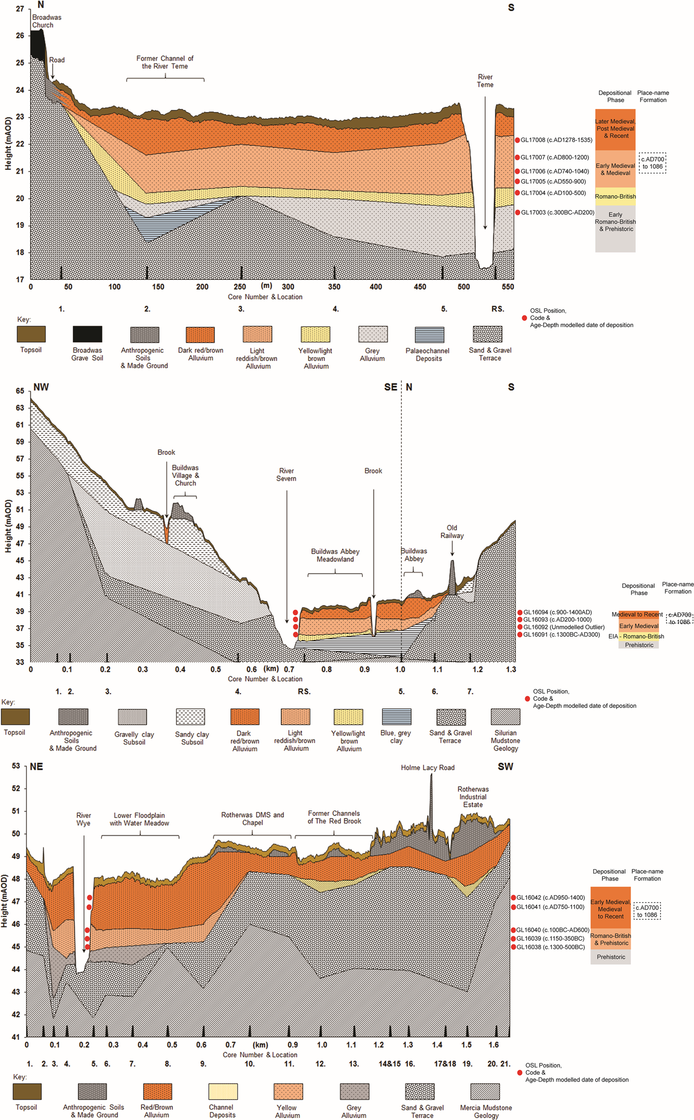
Figure 3. Floodplain sedimentary profiles from Broadwas, Buildwas, and Rotherwas.
At all three sites, the upper unit (the buff-red silty clay sensu Shotton, Reference Shotton, Limbrey and Evans1978) that was deposited over the last 2000–3000 years contains no channel deposits and was vertically accreted, with the channel in approximately its present location. This is a phenomenon well known for the lower Severn and its lowland tributaries (Shotton, Reference Shotton, Limbrey and Evans1978; Brown, Reference Brown and Gregory1983, Reference Brown, Petts and Gurnell1995; Marriott, Reference Marriott1992; Brown et al., Reference Brown, Toms, Carey and Rhodes2013) that has been caused by a combination of low gradients (reaches under 0.001 m/m−1) and high rates of levee and overbank sedimentation. This is the basis of the Stable Bank relative incision model under which rapid rates of vertical accretion over the last 2–3 millennia have confined the river channel (Brown, Reference Brown1997; Brown et al., Reference Brown, Sear, Macaire, Brazier, Klimek, van Oost and Pears2018); although, before the deposition of the superficial unit, channels were mobile and multiple. This has been demonstrated by the identification of buried palaeochannels and, even more dramatically, by the discovery of a Neolithic–Bronze Age monumental landscape preserved under the upper silty clay at Ripple downstream of the Teme-Severn junction (Jackson, Reference Jackson2008). As discussed by Brown et al. (Reference Brown, Sear, Macaire, Brazier, Klimek, van Oost and Pears2018), the situation here is a meandering pattern that has been preserved by rapid levee/overbank deposition which has created incised stable channels with width:depth ratios (α) below α = 7. This is characteristic of bedrock rather than alluvial channels (Finnegan et al., Reference Finnegan, Roe, Montgomery and Hallet2005). The similar but relatively uncommon geomorphological position of the three sites investigated here, all demonstrating confined stability, may be one reason for the relative rarity of the *wæsse place-name element and may offer clues to its specificity, given that all alluvial floodplains flood regularly in this region.
Methodology
At all three sites, river sections between 3 m and 3.5 m of undisturbed alluvium were identified. After cleaning back, sediment colour, texture, consistency, inclusions, and depositional boundaries were recorded, and in situ sediment samples were taken using u-channels for high-resolution laboratory analyses. Summaries of laboratory methods are given here, with full details given in the supplementary material. All physical analyses were conducted at 1–2 cm resolution and included Loss on Ignition (LOI) to determine the percentage moisture, organics, and carbonate essential to determine micro-variations in sediment texture. Percentage moisture has an inverse relationship to particle size and can thus be used to differentiate between high- and low-energy depositional conditions. Organic content offers a measure of the potential development of soils during non-flood periods and their later burial, alongside possible deposition from flood events. Carbonate content can be used to indicate the rapidity of sediment burial and thus frequency of flood events since, if left exposed, carbonate content in the deposited alluvium will reduce through the processes of dissolution, leaching, and soil formation.
The magnetic susceptibility (MS) of the alluvial sediments was established using a Bartington MS analyser. Peaks in MS are created by high levels of Fe and other metallic compounds in the sediment. Since these are present in higher quantity in finer rather than coarser sediments, spikes in the MS graphs can be used as indicators of low-energy depositional conditions or extended periods of waterlogging.
Particle size analysis was conducted to determine the micro-variation in sediment texture throughout the sequences by sieving for the coarse fraction above 2 mm, and a DigiSizer Laser Granulometer for the <2 mm fraction. Since the size of particles within suspended sedimentary loads is positively correlated with flow velocity (the higher the flow velocity, the larger the sediments that can be transported), relative differences in particle size enable interpretations to be made regarding the depositional energies responsible for the creation of each sedimentary lamination. Alongside the physical analyses, high-resolution multi-element analysis was also undertaken using ITRAX X-ray fluorescence (XRF) spectrometry. Thirty-nine elements were analysed at a resolution of 2 mm and the results were used to conduct mineragenic ratio analyses providing additional information on grain size, depositional conditions, waterlogging, elevated water tables, and heavy metals.
Each sequence was dated by optically-stimulated luminescence (OSL) to determine the time that has elapsed between the burial of mineragenic sediments and their exposure to solar radiation. Fifteen dates were obtained from the three sites. These were carefully located at specific points in the sedimentary sequence which were representative of the stratigraphy but contained higher sand concentrations in order to increase the quality of potential dateable material. An even spread of dates throughout each section was maintained to improve the quality of the chronostratigraphic modelling of the calculated OSL dates (Table 1).
Table 1. Summary table of OSL dates obtained from the sequences at Broadwas, Buildwas, and Rotherwas (outliers in red). (Full detailed table in supplementary material.)

From these dates, Bayesian age-depth models have been calculated to determine the vertical accretion rates of the alluvial deposits as well as the likely date of major flood events, with the period ad 300–1150 illustrated as the grey shaded area (Figure 4). The accumulation rates at all three locations investigated are curvilinear, as would be expected from near-channel overbank sedimentation. This is typical of rapidly accreting overbank sedimentation near stable channels (Brown, Reference Brown1997). Bayesian modelling also enabled the identification of possible age reversals and outliers within the sequences (highlighted red in Table 1), and the resultant ‘acceptance’ or ‘rejection’ of those dates. The accepted dates were subsequently converted into calendrical chronostratigraphic Bayesian models using OxCal, version 4.3 with IntCal13 program (Bronk Ramsey, Reference Bronk Ramsey2008, Reference Bronk Ramsey2009). The statistical precision of these calendrical dates can be calculated to, on average, 340 years at 2δ (95.4 per cent confidence) and 169 years at 1δ (68.2 per cent confidence). The dates that are quoted in the discussion of the results have been estimated to 100 years at 52–55 per cent confidence.

Figure 4. Age-Depth models from Broadwas, Buildwas, and Rotherwas modelled using OxCal (4.3). Outliers in red, date ranges in white, and statistical calibration in dark grey.
Depositional and Flood Chronologies
The stratigraphy at all three sites showed laminations to variable degrees indicating that the sedimentary flux exceeded the bioturbation flux. It is therefore possible to derive flood histories at all three locations that extend back to the prehistoric period and forward to the present day. Here only those parts of each sedimentary record relevant to understanding the behaviour of these rivers during the early medieval period, and of potential relevance to the interpretation of the place-name element *wæsse, are presented and discussed. Each chronology begins with a brief discussion of Late Roman depositional conditions to provide context for the early medieval flooding and floodplain development witnessed at these sites from c. ad 400 to c. 1150.
The Teme at Broadwas
During the late Romano-British period (BRD-1 to 3, 275–258 cm), the physical characteristics of alluvial deposition at Broadwas indicate gradually changing conditions (Figure 5). Subtle decreases in moisture, organic, and carbonate accompanied by increases in grain size, total sand, and elemental particle size proxies suggest a shift from frequent low-energy floods to higher energy events.

Figure 5. Chronostratigraphic model for the Teme at Broadwas, c. ad 300–1150.
By the start of the early medieval period (BRD-4 to 5, from 258 cm), these higher energy depositional conditions increased further. A distinct coarsening of the alluvium and much higher sand content and a shift in elemental particle size proxies point to an extended phase of higher energy flooding lasting until the latter part of the sixth century ad (233 cm). During this phase there is evidence for a short but marked change in depositional character. Between 241 and 238 cm, there is a very sharp increase in magnetic susceptibility and paralleled decreases in sediment texture and coarse inclusions. This record potentially corresponds with the ad 536 climatic event, and certainly bears witness, irrespective of the precise trigger, to a distinct episode of flooding and floodplain waterlogging around this time.
Throughout most of the seventh century (BRD-6, 232–218 cm), fluvial activity at Broadwas appears to have calmed somewhat, but nevertheless remained more pronounced than that seen during the Romano-British period. Increased variability in the elemental indicators prove that the Teme flooded regularly and with varying magnitude. After c. ad 630 (226 cm), an increase in average alluvium accumulation rate from 1.3 to 1.7 mm/yr indicates a more rapid build-up of sediments. An accompanying gradual increase in carbonate, the indicator of less dissolution in the alluvium, points to clear flooding events, and the retention of water on the floodplain for extended periods.
Throughout the first half of the eighth century ad (BRD-7 and 8, 218–207 cm) evidence of high-energy deposition is apparent, with clear increases in alluvial texture and most significantly in the sediment power index. This distinctive phase of deposition appears to have abated by the latter half of the eighth century (BRD-9, 206–194 cm), but occasional higher energy flash flooding continued throughout most of the ninth century (BRD-10, 194–179 cm).
From the late ninth to mid-tenth century (BRD-11, 178–165 cm), further coarsening of the alluvial texture, alongside a significant rise in elemental indicators, suggests an increase in fluvial activity and depositional conditions. These higher-energy flood signatures may represent the Teme's response to overarching climatic variations brought on by the start of the Medieval Climate Anomaly.
After c. ad 950, the sedimentological record reveals a reduction in depositional energy which continued for an extended time up to c. ad 1150 (BRD-12 to 14, 167–130 cm). During this period, there is a gradual decrease in coarse-grained components, a decrease in the elemental indicators, and, after c. ad 1035, a clear decrease in average sediment accumulation rate to 1.6 mm/yr. Together this evidence demonstrates a calming of riverine depositionary conditions in the Teme by the end of the early medieval period and the start of the medieval period. Flooding at this time would have been less frequent and of lesser magnitude.
The Severn at Buildwas
Initially, river activity in the late Romano-British period at Buildwas appears to have been dominated by low-energy deposition, with the nature of the alluvium betraying relatively low energy fluvial conditions (BUI-1, 215–211 cm) (Figure 6). During the fourth century (BUI-2, 211–197 cm), however, depositional conditions changed rapidly so that by the end of the Romano-British period the alluvial texture was dominated by a coarse silt fine fraction with a major increase in coarse components. Together these indicate an increase in the magnitude and intensity of flooding at this point on the Severn. The sedimentological evidence suggests that throughout the fifth century ad (BUI-3, 197–182 cm) this high-energy flooding persisted and indeed increased further, leading to a century of coarse alluvial deposition with significant levels of coarse components.

Figure 6. Chronostratigraphic models for the Severn at Buildwas, c. ad 300–1150.
The depositional characteristics of the river began to change from the start of the sixth century and lasted until the mid-eighth century (BUI-4 to 6, 182–145 cm). During this prolonged period there was a significant decrease in alluvial texture and coarse inclusions, alongside increases in other fine-grained sediment proxies. Together, these suggest a marked reduction in flooding intensity and magnitude, and generally more benign river conditions characterized by low-energy, long duration floods.
After c. ad 750, the sedimentary characteristics suggest that the Severn rapidly reverted back to higher energy deposition (BUI-7, 145–137 cm) which intensified throughout the ninth century (BUI-8, 137–127 cm). During the latter part of this phase, the significant change to the alluvial texture suggests a major intensification in frequency and magnitude of flooding on the Severn. From the late ninth to the mid-twelfth century (BUI-9 to 13, 127–90 cm), the sediment character is typically composed of coarse silts with steadily increasing sand inclusions suggesting an extended period of high-energy deposition. Distinctive increases in Zr:Rb and Zr:Fe reveal ever-increasing flood magnitude, with the Severn at its most energetic since the fifth and sixth centuries.
Despite the general high-energy deposition at this time, evidence of very short, lower energy floods can still be determined in the sediment sequence. The enhanced magnetic susceptibility and decrease in grain size at the end of the eleventh century possibly reflects a very brief change in depositionary conditions associated with extended waterlogging, possibly linked to climatic deterioration brought on by the Oort Minimum (c. ad 1040–1080).
The Wye at Rotherwas
During the late Romano-British period (ROT-1 to 2, 210–194 cm), analytical results from the sedimentary record for the Wye at Rotherwas indicate a period of decreasing flood intensity and magnitude (Figure 7). The presence of a significant peak in magnetic susceptibility and drop in Zr:Rb suggests a clear phase of lower energy fluvial conditions in the late fourth century. At the beginning of the early medieval period, fluvial conditions appear to have continued as before. Through the fifth to the late sixth century (ROT-3 to 5, 195–170 cm,) the general texture of the alluvium continued to decrease alongside the coarse components, suggesting a further reduction in fluvial conditions and flood intensity.

Figure 7. Chronostratigraphic models for the Wye at Rotherwas, c. ad 300–1150.
After the late sixth century, the Wye demonstrates a significant change in depositionary characteristics marked by a clear change in the sedimentology. Between c. ad 580–640 (ROT-6, 170–162 cm), a distinctive coarse silty sand with fine gravels dominates the sequence, the physical signature left by a period of very intensive, high-energy flooding. This must have had a significant impact on the floodplain landscape given the relatively benign conditions of the previous three centuries. No historical records exist which describe the extent and effect that this period of flooding had on the local populations but it is clear from the sedimentological record that the sudden change in river dynamics would have dramatically altered how people occupied and used the floodplain for many years.
This episode of extreme deposition, however, was short-lived. From the mid-seventh to the late ninth century (ROT-7 to 10, 162–130 cm), the river returned to much lower-energy depositional conditions. Throughout this period, medium to fine silt alluvium dominates the sequence with considerably fewer coarse inclusions, suggesting lower energy flood events. Within this phase, however, several coarser-grained horizons point to very occasional higher energy floods between c. ad 750–850, but, on the whole, these appear to have been rare events.
From the tenth to the mid-twelfth century (ROT-11 to 14, 130–70 cm), the heterogeneous sedimentary characteristics of the alluvium suggest regular alternation between high- and low-energy depositional conditions. More generally, the gradual shift to coarser alluvium with greater concentrations of coarse inclusions and a distinctive increase in average accumulation rate (from 1.7 to 2.3 mm/yr) indicate increasingly higher energy deposition over time associated with more frequent and greater intensity floods. Occasional shorter phases of low-energy deposition do occur at this time, marked by clear increases in magnetic susceptibility and carbonate, but, on the whole, these events are rare.
Discussion
These new chronostratigraphic sequences serve to extend significantly our understanding of the fluvial dynamics of the Severn, Teme, and Wye during the early medieval period. When compared against each other, these rivers display a degree of synchronous behaviour, but not uniformity, perhaps reflecting the individual traits of their respective catchments’ characteristics and histories (Figure 8). There are broad similarities in the patterns of sedimentation across the three sites. All three sequences show, for instance, more frequent and more energetic flooding in the earlier part of their sequences than in later periods. More specifically each of the sites shows a higher degree of riverine activity in the immediate post-Romano-British period between the fifth to the seventh centuries. After c. ad 650, all the records demonstrate a decline in flood intensity; this is most apparent at Broadwas and Rotherwas, but at Buildwas only to a lesser extent perhaps due to its larger catchment.

Figure 8. Estimated flood magnitude models for Broadwas, Buildwas, and Rotherwas.
The period between the mid-seventh to the mid-ninth century exhibits the most variability in fluvial activity across the three sites. The Severn and Teme appear to have been much more active than the Wye, but at all the sites rhythmical extremes between larger and smaller flood events can clearly be seen implying greater flood variability. In short, these rivers appear to have been behaving in a more erratic manner. Those living close to these rivers would have been only too aware of their unpredictable nature and the challenges they then posed to the full exploitation of both the rivers themselves and their rich floodplains. In contrast, there is broad synchronicity between the tenth and mid-eleventh centuries when there is a distinct increase in riverine activity and flood magnitude on all three rivers, albeit at different scales. The Teme and Wye demonstrate further continuity into the mid-twelfth century, whereas on the Severn there is a marked decrease in activity.
Some correspondence in the behaviour of these three rivers would be expected. All are adjacent, and their catchments fall predominantly within the southwest England precipitation area defined by Gregory et al. (Reference Gregory, Jones and Wigley1991), but the flood histories of basins will always vary due to a combination of topographic, geological, and land-use variables. The flood histories of the *wæsse-sites that have been presented here appear to correspond to Macklin et al.’s (Reference Macklin, Johnstone and Lewin2005) study of major riverine flood probability within this precipitation zone. They isolated two phases of elevated flood activity, between c. ad 250–500 and c. ad 750–1100, and the results from the *wæsse-sites broadly follow this model. Both they and others (Jones et al., Reference Jones, Lewin and Macklin2010, Reference Jones, Macklin and Brewer2012) have correlated these periods with wetter climatic phases identified, for example, in the Irish bog oak record between c. ad 750–850 (Leuscher et al., Reference Leuscher, Sass-Klassen, Jansma, Baillie and Spurk2002) and in the coterminous evidence for very elevated water-levels in northern British peatlands (Charman et al., Reference Charman, Blundell, Chiverrell, Hendon and Langdon2006). These wet phases have also been correlated with solar minima (Larsen et al., Reference Larsen, Vinther, Briffa, Melvin, Clausen and Jones2008). Nevertheless, it would appear that specific fluvial responses at Broadwas, Buildwas, and Rotherwas to these climatic episodes varied. This is perhaps best explained by the different scales of their respective river catchments: the Teme at 1640 km2, Wye 4136 km2, and Severn (excluding the Wye) 11,420 km2. During wetter periods, the carrying capacity of the Severn was much more likely to be exceeded than along the Teme and Wye as a result of the collection of greater quantities of water from its more extensive catchment with a greater area of upland. This is borne out in the sedimentary record which reveals the Severn to have been more prone to higher magnitude and more frequent flooding than the others.
For the most part, it is now accepted that while the flood behaviours of British rivers are principally driven by climate (Macklin et al., Reference Macklin, Jones and Lewin2010, Reference Macklin, Lewin and Woodward2012), their sedimentary flux is also a product of land-use history (Brown et al., Reference Brown, Toms, Carey and Rhodes2013). In general, anthropogenic landscape change appears to have been a less significant factor in flood records, at least until c. ad 950, after which the rates of accumulation of fine silts rise rapidly nationwide. This is considered to represent the signature of the expansion of arable farming and the delivery of greater sedimentary loads to rivers through the erosion of exposed soils (Macklin et al., Reference Macklin, Jones and Lewin2010; Brown et al., Reference Brown, Toms, Carey and Rhodes2013). Across the whole period covered by the new sequences, however, overbank rates of alluvial accumulation at all three sites appear to vary very little but remain high (see below). This appears to indicate a relatively stable catchment environment, and this interpretation is supported by palynological and archaeological evidence. Aggregated data from upland Wales, where all three of these rivers originate, indicate a consistent if small increase in woodland across the early medieval period. Arboreal pollens also indicate that in the western lowlands, relevant for an understanding of the middle and lower courses of all three rivers, woodland cover was again largely preserved for most of the period and may have actually increased in the immediate post-Roman period before declining after ad 850 (Rippon et al., Reference Rippon, Smart and Pears2015). Signs of any expansion of arable cultivation are negligible in both regions. Such landscape continuity may help to explain the relatively constant rates of flood sedimentation at the *wæsse-sites which remained, over the whole of the early medieval period, between 1.19–2.31 mm/yr. That said, for English lowland rivers, such rates are relatively high. Certainly, on the three sites examined here, the accumulation of alluvium was sufficiently rapid not to allow bioturbation and reworking of flood laminations, explaining why sediment preservation is so good in these places.
The material deposited was generally relatively coarse, being dominated by silts and sand. This reflects the regional geology and nature of the floodplain, particularly the fixed location of the river channels. Of course, the nature of flooding at *wæsse-sites need not necessarily mirror what was happening elsewhere in these river catchments. Indeed, the adoption of a unique term to describe the phenomenon may point to the fact that flooding in these locations was recognized as being substantively different from that observed in other places. What each of the sequences unequivocally demonstrates is that all three *wæsse-sites were located on reaches with high-unit stream power but also with channel stability. Such river reaches were of fundamental importance to the early medieval economy, providing excellent conditions for the placement of mills as well as weirs and fords.
The sedimentary sequences at these *wæsse-sites provide new data that help to refine previous models developed for river behaviours and floodplain development across the early medieval period, both in terms of flood chronology and sediment accumulation. These have previously been difficult to build securely from radiocarbon-dated sequences (Brown et al., Reference Brown, Sear, Macaire, Brazier, Klimek, van Oost and Pears2018). Beyond their general value, however, the results are of particular relevance for the interpretation of the unique conditions which might have been being described by the term *wæsse in riparian settlement-names.
It is sensible to assume that, wherever deployed, *wæsse was intended to describe the same natural process or set of characteristics. However, if we also assume that the three west midland names—Broadwas, Buildwas, and Rotherwas—came into existence at about the same time, it is difficult to identify a period when all three sites were subject to the same specific riverine behaviours. It is tempting to assign the names to the period before the mid-seventh century ad, when all three rivers flooded regularly. It is, however, extremely unlikely that Old English was sufficiently well established at that date, this far west, for *wæsse-names to have arisen then (Bassett, Reference Bassett2000).
The degree of fluvial variability in river behaviours evident after the eighth century thus presents a challenge to the interpretation of the name and the fluvial phenomenon it describes. Yet despite the variability in their later detailed flood chronologies it is the case that certain types of flooding event were shared in common at each *wæsse-site. They all underwent both higher-energy, shorter-duration events and smaller, more prolonged flooding during the centuries when we might expect the names to have arisen (perhaps from c. ad 650-950). In these circumstances, it is difficult to be confident that Gelling's (Reference Gelling2012: 103) definition of *wæsse as a highly specialized term for land by a river which floods and drains with dramatic swiftness is the one that specifically applies, even if the sedimentary data does broadly support this interpretation. If the term were indeed linked to high-energy flood events, then we might note the extended period of the most intense fluvial activity at Buildwas during the late-eighth century as one likely context in which the name might have been adopted. Similarly, the intensification of flood activity on the Teme from the mid-ninth century might account for the Broadwas name. However, comparable conditions on the Wye which might explain Rotherwas are entirely lacking before the eleventh century ad. These non-synchronous chronologies do not, in themselves, pose a problem since the names and the places to which they were attached need not have been necessarily or strictly contemporaneous with one another.
Rather than trying to identify a shared chronology for the naming of *wæsse-sites, it is perhaps better to consider how individual flood events may have physically manifested themselves on the ground during the latter part of the early medieval period, since an equally likely origin of *wæsse might lie in the precise fluvial dynamics of floods common to all locations taking this name. In all instances examined here, downstream obstacles to the free flow of water exist. At Buildwas, it is the constriction of the Severn's floodplain as it enters the Ironbridge Gorge. When heavy rains occur in the upper catchment, the Severn's flood pulse is able to move downstream unhindered until it reaches the Gorge. If this pulse exceeds the capacity of the Gorge, then water backs up causing floods at Buildwas. At Broadwas, the same effect is observed when water travelling down the Teme is unable to enter the Severn. This is particularly true when the Severn is in flood, an event which last occurred in 2007. The same phenomenon occurs on the Wye at Rotherwas when the River Lugg is in spate. The effect of this pooling is a rapid rise in river levels at all three *wæsse-sites leading to extensive overbank flooding as downstream flows meet the blockage. Equally, once the obstruction clears, there comes a moment when water previously standing on the floodplain is syphoned off, causing the floodplain to drain rapidly too.
All of which brings us back to Gelling's observations and her extended meaning of *wæsse as ‘land by a meandering river which floods and drains quickly’. Implicit in her model is that individual flood events were of short duration (from her field observations, 24-hour events). The sedimentological record, however, suggests that, in reality, some flood events might be of long duration and the geoarchaeology explains why. What is clear is that, in all three locations, it is both the onset of flooding and its conclusion that occur rapidly even if water might cover their floodplains for considerable periods between times. It would appear, then, that it was not only the tendency of these places to flood and the frequency with which this happened that place-namers sought to communicate by using the *wæsse element in place-names, but also the alarming speed at which these floods might rise and the comforting speed at which they receded. If these specific riverine characteristics might, from time to time, threaten the communities who lived and worked in these locations, they might also be exploited, thus explaining, perhaps counter-intuitively, why permanent settlements might be established in such places. River reaches with high stream powers and fixed channels, as found at these *wæsse-sites, provided the most effective locations for the construction of on-stream watermills as well as weirs (e.g. fish weirs) and fords. Given such economic potential, it may be significant that two, and possibly all three, of these *wæsse-sites possessed watermills by the late eleventh century.
Conclusion and Wider implications
This paper has offered a new methodology for conducting fluvial geoarchaeological research and the first OSL-based early medieval flood chronology in the UK. It has demonstrated the value of using place-names to target particular river sections where the fluvial processes described in these names can be tested against the physical evidence of sedimentary records. Here, only one place-name element, Old English *wæsse, has been examined in detail. It is suggested that Old English speakers recognized *wæsse-sites as unusually high-energy locations: prone to flooding, yet still suitable for permanent settlement, river crossings, and the development of economic assets such as mills (Brown et al., Reference Brown, Sear, Macaire, Brazier, Klimek, van Oost and Pears2018). There is great potential to extend this methodology further. Other English place-name elements that potentially describe locations where distinctive signatures of fluvial activity may have been left include: botm ‘flat alluvial area, restricted in size, moist and often easily flooded’ (Cole, Reference Cole1987–88); flēot ‘shallow water coming and going’ (Cole, Reference Cole1997); halh, variously seen to refer to ‘low-lying land higher than its surroundings but still liable to occasional flooding’ or ‘low-lying land liable to (infrequent) flooding’ (Stiles, Reference Stiles, Rumble and Mills1997; Kitson, Reference Kitsonforthcoming); hamm, with potentially multiple senses including ‘land in a river bend; river-meadow’, ‘piece of valley-bottom land hemmed in by higher ground’ and the more general implicit sense ‘land liable to flooding’ (Gelling & Cole, Reference Gelling and Cole2000: 46–49); and wisce/wixe ‘a piece of land in the bend of a river liable to floods’ (Smith, Reference Smith1956ii: 270). The method might also profitably be used to examine the behaviour of rivers based on the names they carry. It might be expected, for instance, that the River Tove ‘slow, dilatory, laggardly one’ will have left a different sedimentological profile than the River Swale ‘whirling, rushing river’ (Ekwall, Reference Ekwall1928; Watts, Reference Watts2004). Finally, since the two dominant languages, Old English and Old Norse, from which English place-names and to a lesser extent its river-names were formed are both Germanic branches of the wider family of Indo-European languages, this is a methodology that should find potential application beyond the British Isles in the examination of the geomorphological and geoarchaeological character of rivers across Europe, including Scandinavia.
Supplementary Material
To view supplementary material for this article, please visit https://doi.org/10.1017/eaa.2019.72.
Acknowledgements
This work was supported by the Leverhulme Trust under Grant RPG-2016-004.


