
The study of rural non-élites in the Roman world, for which ‘peasants’ is a convenient shorthand, has proceeded principally along textual lines. Since Peter Garnsey's 1979 article on the location of peasant houses (Garnsey, Reference Garnsey1979), much of the work on rural non-élites has been based on legal sources, papyrological material and agricultural handbooks (for example: Neeve, Reference Neeve1984; Kehoe, Reference Kehoe1997; Lo Cascio, Reference Lo Cascio1997). As the scholars who work on these materials acknowledge, even the papyrological data are lacunose, while legal and literary sources reflect élite perspectives and discourses.
Archaeology's principal contribution has been in the form of field survey. The focus has been on settlement patterns and the spatial-hierarchical relationships between smaller and larger sites (for example, in Italy: Potter, Reference Potter1979; Barker, Reference Barker1995; Carandini et al., Reference Carandini, Cambi, Celuzza and Fentress2002; Patterson, Reference Patterson2004). In northern Europe, many of the smaller sites found in survey have been excavated: in Italy the number remains relatively small, and those subject to modern open-area excavation smaller still (for example: Jones, Reference Jones1963; Delano-Smith and Gadd, Reference Delano-Smith and Gadd1986; Perkins and Attolini, Reference Perkins and Attolini1987; Motta, Reference Motta1997; Ciampoltrini and Zecchini, Reference Ciampoltrini and Zecchini2005). Archaeological data on Italian Roman peasants thus remain confined to topographic questions, while issues of domestic architecture, diet, agricultural techniques and social relationships remain largely un-interrogated (Witcher, Reference Witcher2006a; Reference Witcher2006b).
The Roman Peasant Project was begun in 2009 as a systematic investigation of Roman non-élites in the comune of Cinigiano in western Tuscany. The result of a collaboration between Cornell University, the University of Pennsylvania and the Laboratorio di Archeologia dei Paesaggi e Telerilevamento (LAP&T) at the Università di Siena/Grosseto, the project uses the results of a surface survey carried out by one of the authors (Ghisleni, Reference Ghisleni2010), and excavates the smallest Roman sites and off-site scatters located by that survey. The resultant architectural, ceramic, faunal, palaeobotanical and geo-archaeological data will provide the backbone of a comprehensive analysis of Roman peasant life-ways, including housing, diet, economies and locales. The project is chronologically inclusive, examining sites ranging from the second century bc to the sixth century ad.
This article presents the results of the first season of this project, the excavation of a late Republican and late Roman farmstead at Pievina.
PROJECT AREA
Set at the far eastern corner of the province of Grosseto, the comune of Cinigiano lies at the interface between the coastal plains and the more mountainous inland territory of Montalcino (Fig. 1). As such, it is topographically diverse — gently rolling hills and open valleys to the west, hilly vineyard-covered regions to the north, and the forested slopes of Monte Amiata to the east. Set between the Via Aurelia and the Via Cassia, and some distance from the nearest Roman cities (c. 30 km from Roselle and Saturnia), its position in the Roman period was peripheral — at least to the major axes of communication, loci of administration and the major littoral production regions of southern Etruria. Archaeologically the region has received little attention and the first systematic work was undertaken from 2006 to 2010 by one of the authors (Ghisleni).

Fig. 1. Cinigiano (GR), map showing the Roman-period site and off-site scatters, the location of Pievina and two possible ancient route-ways.
That study used surface survey, combined with aerial photography and select geophysical survey, to reveal some 467 sites and off-site scatters, nearly all of which were documented for the first time (Ghisleni, Reference Ghisleni2010). The region seemed ideal for the study of the Roman peasant. Most sites were identified as small farms or agglomerated nuclei termed ‘villages’: only one villa was found. Owing to the continued centrality of modern grain production and the relatively recent spread of viticulture, site preservation is relatively good. Relatively lower-level or ‘poor’ material culture outweighs signs of wealth, potentially simplifying the tracing of hierarchical relationships. Disadvantages also accrued to the study area. Its peripheral geography and, concomitantly, its different material profile, including the more subdued villa presence, mean that many of the results would not necessarily apply to the coastal region and its seemingly distinct socio-economies.
PROJECT METHODOLOGIES
The Project seeks to move from study based on isolated case-studies, which has characterized the lacunose work on Roman peasants, to systematic data collection from multiple sources. In this respect, it seeks to bridge the gap between excavation, with its emphasis on the single site, and field survey, with its more superficial data from many sites (cf. Haselgrove, Millett and Smith, Reference Haselgrove, Millett and Smith1985: 2; Cunningham and Driessen, Reference Cunningham, Driessen, Alcock and Cherry2004; Attema and de Haas, Reference Attema, Haas, Frizell and Klynne2005; Groot et al., Reference Groot, Heeren, Kooistra and Vos2009). It does so by seeking to excavate multiple small sites, at speed. Much of the project methodology is structured around this principle.
The project focuses on the three smallest size categories identified by the 2006 survey (>0.05; 0.05–0.15; 0.15–0.5 ha), and any functional categories thereby included, as well as some scatters classed as off-site.Footnote 2 However, rather than reinforcing a presumed association between peasants and small site size, other materially poor but spatially and functionally diverse sites are also examined, including sites classed as large settlements and villages.
Recent debates have questioned the ability of field survey to detect particularly small or materially poor sites (Francovich, Patterson and Barker, Reference Francovich, Patterson and Barker2000; Pettegrew, Reference Pettegrew2001; Bintliff et al., Reference Bintliff, Farinetti, Howard, Sarri and Sbonias2002). The debate affects this project insofar as: (a) small sites may produce surface remains only sporadically, if at all (Terrenato and Ammerman, Reference Terrenato and Ammerman1996); (b) the smallest/poorest farms actually might be represented by so-called ‘off-site’ scatters (Pettegrew, Reference Pettegrew2001); (c) the ‘sites’ collected in survey may not represent actual subsurface remains, but manuring or other processes (Bintliff and Snodgrass, Reference Bintliff and Snodgrass1988). The first problem is not overcome easily, except by extensive geophysical survey, which is impractical in this region (see, for example: Campana, Francovich and Felici, Reference Campana, Francovich and Felici2005). The second and third can be tested by excavating off-site scatters and through small-scale geophysical survey before excavation begins. All sites in the project thus were subjected to magnetometry survey prior to excavation, both to gain some insights as to their spatial relationship with the surface scatter and to their functional character.
In order to produce the multiple data clusters required by the project, we integrate practices common to rescue archaeology with standards of research archaeology (cf. Andrews, Barrett and Lewis, Reference Andrews, Barrett and Lewis2000), including use of mechanical excavation equipment to remove topsoil from large areas, high-resolution kite-photography, in-process site photos, and more restricted use of hand-drawing. All sites are backfilled at the end of the season, permitting land to be returned to agricultural use immediately and fostering good relations with local landowners. The micro-region around each site is subject to an environmental and topographic assessment, analysing soil potential, geological and hydrological resources, and potential route-ways and barriers. Finally, hand-sieving of both random and high-value contexts provides controls over faunal and palaeobotanical samples. The palaeobotanical materials are still in the process of study.
SURVEY AND EXCAVATIONS AT PIEVINA
The site of Pievina lies mid-slope on a low hill sloping from southeast to northwest (Fig. 2). At the bottom of the hill to the west is a modern fontone — a shallow, probably man-made depression to collect water, common in Tuscany and set near less permeable terrain belts that collect groundwater from aquifers located uphill (Arnoldus-Huyzendveld, Reference Arnoldus-Huyzendveld and Valenti2008). A spring was reported, but not located, uphill to the southeast. These two factors — the slope and the nearby presence of groundwater — emerge as major factors in the site's human history.

Fig. 2. Pievina, the site topography, with a sketch of subsurface geological and hydrological features.
Pievina is set near a cluster of Roman sites, its nearest neighbor about 1.5 km to the northeast and a near twin to Pievina in size, chronology and surface aspect. More important neighbours are two possible route-ways: the modern road from Cinigiano to Monticello Amiata follows a ridge and is the only east–west passage in the area, while a sequence of Roman-period village settlements running from the river Orcia northwards may indicate a north–south route (Ghisleni, Reference Ghisleni2010: 84–6) (Fig. 1).
Surface survey revealed seven discrete scatters of material, loosely organized in a circle of c. 2 ha, with a large space empty of material in the centre (Fig. 3). All of these scatters produced material datable to the first century bc to first century ad.Footnote 3 Over-fired tiles of late Republican date were found spread over several scatters, possibly pointing to the presence of a tile-kiln, but not indicating its precise location. No material of second- to third-century date was found. For the fourth to fifth centuries, the site again produced evidence of occupation, but only in Topographic Units (TU) 290, 291, 286 and 287.Footnote 4 In its first phase, the site thus resembled the other agglomerated ‘villages’ located in the survey, while in late antiquity the site seemed to have shrunk and was labelled a house or small farm.

Fig. 3. The surface and geophysical survey, together with the excavated areas. Topographic Units (TU) refer to discrete surface scatters.
The decision to excavate Pievina was influenced by three factors. The first site excavated by the Project should be sufficiently representative to test the project's methodologies, but middling in terms of size and degree of preservation so as to permit the unavoidable errors and learning attendant in any first season. At the large end of the size spectrum, but materially relatively poor, Pievina fitted these criteria. It also was deemed important to begin with a site some distance from the area's main villa so as to reveal a site removed, at least spatially, from a nexus of élite power: Pievina lies some 5.9 aerial km from that villa and further separated by challenging topography. Finally, the site was slated for conversion into a vineyard, which would result in the destruction of subsurface remains.
Geophysical survey at Pievina utilized two different instruments: a Foerster 4.032 and an Overhauser GEM (GSM-19GW), the latter in walking mode. As the far northern and western parts of the site sloped considerably, only 1–1.5 ha were surveyed. The Foerster survey was largely unsuccessful, showing very little variation in the plots. The GEM survey, however, located several clusters of anomalies, all but one of which overlapped at least in part with the surface scatters (Figs 3 and 4). The exception was a particularly intense dipole in the site's centre, whose concentration and strength indicated a kiln. Beneath TU 286, a possible linear anomaly running northeast–southwest was joined by a line of more fragmented anomalies running at right angles, possibly suggesting the outlines of a building.

Fig. 4. Detail of the geophysical survey results, using an Overhauser GEM, overlaid with the excavated results.
Two areas were selected for excavation, corresponding to TU 286 and 287, and comprising some 930 m2 (Fig. 3). Efforts to extend the excavated area to the south were scrapped after groundwater was encountered. Areas to the northeast, northwest and southeast that produced strong anomalies and the other scatters not covered by geophysics were not excavated. The implications of having excavated only about 21% of the surface scatter area (c. 4,450 m2) are discussed below (p. 133).
RESULTS (Fig. 5)
As the surface data suggested, the site included major periods of occupation in the second to late first centuries bc and in the fourth to mid-fifth centuries ad, separated by a hiatus during the second and third centuries ad. The presence of a kiln in the first phase was confirmed. However, the functional character of the site, both as a late Republican village and a late antique farm, was somewhat different than expected.
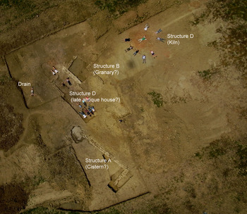
Fig. 5. Kite-photograph, with students for scale and showing the major features.
PHASE 1. LATE REPUBLICAN/EARLY IMPERIAL FARMSTEAD? (Fig. 6)
The interpretation of this phase was hampered by the presence of groundwater at high levels in the east, the poor degree of preservation to the northwest, and the development of the late antique settlement immediately over the site to the southwest. To the east, two sides of a large, well-built masonry structure (Structure A) were revealed, built of double-faced walls 0.6 m wide. To the west of this a line of geophysical anomalies, running parallel to the structure's east wall, may indicate the third wall of what was a possible rectangular structure measuring some 14 × 7 m, but groundwater prevented the testing of this hypothesis. A 2.5 m deep trench in the presumed inside of this structure failed to reach either a floor or the bottom of the walls.

Fig. 6. Plan of Phase 1: the late Republican/early Imperial (second-century bc–first-century ad) site.
These facts, in combination with the insertion of a drain channelling water into the structure's interior (Fig. 7), the much higher occupation levels of contemporary date to the west, and the occasional presence of cocciopesto fragments inside the trench, all suggest a cistern. In further support may be aspects of the underlying geology (Fig. 2). The site was found to be located near the interface of yellowish fine sandy (loamy) surface layers with a grey clayey epipedon with surface cracks. The site lies at an interface between clayey layers to the southwest and northeast, and sandy layers in between, with clayey gradually replacing sandy as one moves down the hill. This distribution may have produced a small aquifer in which the water within the coarser layers was forced to the surface by the finer layers. The hypothetical cistern was built near one of these sand/clay divides.

Fig. 7. Structure A (cistern?) with a drain (1002), from the east.
The area to the northwest was much disturbed by ploughing and no occupation levels were found. A second wall, more or less parallel to Structure A, and of similar mortared construction (1503), lay at the southeast end of a double line of piers, built of dry-stone masonry. A capping wall of dry-stone masonry terminated this structure at the north. With its double line of piers and the absence of continuous outer walls except at its short ends, this building (Structure B) was identified tentatively as a raised-floor granary, measuring 12 × 5 m. We imagine the piers to have supported a wooden floor, of which all traces were destroyed by ploughing; while the absence of large quantities of building stone, and the occasional discovery of thick, green clay between the stones of Structure B suggest pisé walls built atop a socle of rubble. The different construction technique of 1503, built in mortar, suggests an earlier wall, reused in the construction of the dry-stone granary, while the function of an L-shaped extension on the building's east side remains unclear. A single post-hole (1557), dated by C–14 to the late Republican period,Footnote 5 was found near the western piers, and would seem to be a broadly contemporary prop. Trenches in the south end of Structure B revealed a usage or floor-levelling layer containing black-glazed ware, providing a general late Republican date (second–late first century bc).
Some stones in the piers, as well as the prop stone in the single post-hole, were broken millstones (see also below, pp. 132–3); this fact, plus the very different construction character of the building's south wall (1503), may indicate that Structure B replaced an earlier building, possibly a granary or mill, and made use of one of its walls. No other trace of this earlier structure or its stratigraphy was found.
To the west of Structure B lay an open area, in which was found a hearth (1530), built into half of a reused dolium and cut into a packed surface. The fill (1542) was rich in charcoal, uncharred faunal remains, cooking pots and some black-glazed ware. The fact that the faunal remains were not burnt may suggest that all or part of this fill was a secondary rubbish deposit, dumped in the hearth after its abandonment. The sequences here of packed surface, hearth and abandonment occurred in periods too short to be distinguished by ceramic dating. As with Structure B, the ceramics suggest a broad date in the second to first centuries bc.
To the north of Structure B was a kiln (Structure C), as indicated by the geophysical data (Fig. 8). The kiln was roughly rectangular, oriented northeast–southwest, its opening in the southeast corner. Partly covering its northwest corner was a sizeable dump (2003), containing large chunks of carbonized wood, broken and over-fired roof-tiles (imbrices and tegulae), as well as ceramics associated principally with cooking and storage (see below, pp. 112–17). The kiln itself was completely empty, and although no definitive wasters were found, the large number of broken and over-fired tiles in the dump suggests its principal use was for tile production, while the other ceramics probably derive from a nearby (but un-located) domestic context. The kiln is provided a terminus ante quem by the dump, dated to the second half of the first century bc.Footnote 6

Fig. 8. Aerial view of Structure C, a tile-kiln.
The stratigraphic evidence hints at a number of sub-phases ranging some time from the second century bc to the first century ad. The similarity in construction and orientation of wall 1503 and Structure A, the reuse of wall 1503 and the reused millstones in Structure B, and the absence of Arretine sigillata in the hearth (1530) and ‘granary’ tentatively suggest a succession of structures, beginning with the cistern and culminating in the dump (2003) and the abandonment of the kiln in the mid- to late first century bc.
The abandonment of this phase seems similarly varied. The hearth abandonment (1542) dates at the latest to the first century bc, while the kiln was abandoned possibly somewhat later, in the second half of the first century bc. A clayey deposit (1004) filling Structure A seems to have been part of a localized, but significant, colluvial event, probably a landslide detected just to the west of the excavated area. The east wall of Structure A (1010) was angled steeply down, while its corner jutted up, a result seemingly of the weight of clayey colluvium. The ceramics from this level, carried with the colluvium from elsewhere on the site, suggest an abandonment date not before the first half of the first century ad.Footnote 7 The somewhat later ceramics in this colluvium, and residual ceramics datable through to the end of the first century ad found in late antique levelling-up contexts (see below, pp. 111–12), suggest that unexcavated portions of the site may have persisted somewhat longer.Footnote 8
Virtually no second- to third-century ceramics were identified. A number of second- and third-century coins was found in late antique contexts, but it is not clear if these are the result of redeposition of second- and third-century contexts from the site, or the continued circulation of these coins in late antiquity. Thus, from the early to mid-second to the early fifth centuries, the site seemingly was abandoned.Footnote 9
PHASE 2. LATE ANTIQUE REOCCUPATIONFootnote 10 (Fig. 9)
Phase 2.1: the construction/use of Structure D
The colluvium that filled the cistern extended over much of the southeastern part of the site and a late antique stratum covered Structure B, suggesting that this, too, was in ruins. The reoccupation was focused in the western parts of the site, and consisted of the reuse of one wall of Structure B to build a new building (Structure D), the laying-down of a succession of large beaten-earth surfaces, and a system of drains.

Fig. 9. Plan of Phase 2.1: the late antique (early–mid-fifth-century) site.
Structure D was begun with the laying of a beaten earth floor (1025) packed with broken tiles, clay and small pebbles against the earlier wall (1503) (Fig. 10). Two wall socles, composed of unmortared river cobbles, were then laid on top of this floor to form a roughly square structure, measuring 4.3 × 4.5 m, open to the east and with a doorway to the west. The upper walls were again constructed of pisé, found collapsed over the floor. To the east extended a floor (1031) of somewhat coarser matrix but seemingly contemporary construction, while post-holes continued the line of the structure's south and north walls, with a large post-hole in the centre of the coarse floor.

Fig. 10. Aerial view of Structure D (a late antique ‘house’).
It would thus seem that Structure D was conceived from its beginnings as a mixed-technique structure, with a west ‘wing’ of cobble-socles and pisé walls and an east ‘wing’ in wood. Possible signs of a wall cut running between the posts were traced on the south side, but not on the north: thus, it remains unclear if this post-built extension was open or closed to the elements. An intact tile roof collapse covered both ‘wings’, suggesting a tiled roof throughout.
No installations were found within Structure D that provide a clue to its function. The abandonment contexts produced a wide functional range of domestic ceramics from fine-wares to storage and transport vessels, and thus provide no real functional indicators. The construction distinction between the tiled ‘wing’ and the post-built ‘wing’ might suggest different functions, particularly if the post-built wing were open to the elements: the post-built wing might have been used to house animals or for storage, for instance. We ultimately have labelled this structure a ‘house’ with some reservations, discussed below (p. 133).
To the south of Structure D, and seemingly part of its original construction or attributable to a moment soon after, a series of drains was laid. These were composed of medium-sized river cobbles laid in two parallel lines covered by smaller cobbles that acted as a cover and filter (Fig. 9). Contemporary farmers interviewed still construct drains in this manner both for water channelling and to mark field and property boundaries. The Pievina drains seem to have channelled water from the eastern water-prone sections of the site towards the west — where the fontone at the hill's base suggests that groundwater naturally pooled (Fig. 2).
Between Structure D and the drains the same beaten earth surface (1538) that constituted the floor of the house (1025) continued. This seems to have been laid simultaneously with the house floor and served as the paving for a yard. On top of this floor layers of rubbish accumulated, rich in faunal and other organic remains as well as pottery.
To the west of Structure D a succession of beaten earth surfaces was laid out, very similar to the floor of the house. Into the last of these was set yet another drain (1513), composed of reused imbrices. Framed by a rough semicircle at its upper, east end, the drain may have acted as a gutter, drawing away run-off from Structure B's roof, which we thus hypothesize was pitched in this direction.
Phase 2.2: the abandonment/collapse of Structure D
The abandonment level (1018) beneath the tile roof collapse (1026) was thin, suggesting a short period between these two events. An almost complete large bowl in colour-coated ware imitating ARS Hayes 61 was found crushed by the collapse, and the relatively high ratio of diagnostic fragments to MNI (3.6:1 (see below, Table 1)) suggests a sealed primary deposit.
Table 1. Sherd count, weight and MNI of diagnostic and non-diagnostic fragments. Major contexts considered in detail here are 2003 and 1006.

Even more than in Phase 1, a succession of superimposed surfaces and cuts points to a rapid succession of changes whose absolute chronology is finer than is detectable by either C–14 or ceramic dating.Footnote 11 The house abandonment and collapse levels produced African red slip ware broadly dated to the late fourth to the early fifth centuries ad.Footnote 12 The numismatic evidence, in the form of some 37 coins and coin fragments, narrows that span towards the early fifth century for both the construction/occupation and abandonment of Structure D.Footnote 13
Phase 2.3: new surfaces over collapsed Structure D (Fig. 11)
Above abandoned Structure D, new occupation took place, consisting of another beaten earth surface. Above the roof collapse, the ground was levelled up with a thick layer (1018), rich in faunal material, ceramics and tiles, and containing significant quantities (some 18.4% (MNI twelve)) of residual ceramics, an anachronistic faunal profile,Footnote 14 and a Tiberian as, as well as two fifth-century AE4. This levelling-up layer was capped by another beaten earth and ceramic surface (1008). No evidence of structures was found.

Fig. 11. Plan of Phases 2.3 and 2.4: the late antique (mid- to late fifth-century) site.
Phase 2.4: a rubbish tip
Into this surface (1008) a large (1.5 m diameter) hole was later cut (1006), containing a dump of organic-rich material, as well as ceramic and faunal materials. The ceramic assemblage was abraded and contained a low sherd count per MNI (1.37:1), and the faunal material had a higher percentage of carnivore-gnawed bones, suggesting the secondary deposit of materials originally dumped elsewhere. The cut thus might represent an original cesspit, later filled with redeposited rubbish coming from different parts of the site (cf. Peña, Reference Peña2007: 308).
Again, the absolute chronology is too coarse to distinguish Phase 2.3 from Phase 2.4 in precise terms. The ceramics and coins indicate a mid- to late fifth-century date for both the new surface and the rubbish tip, some 30–40 years after the abandonment of Structure D.Footnote 15
CERAMICS (EV)
Since the project is interested particularly in the eating habits, as well as the micro-economies of peasant farmers, the ceramic data were analyzed in light of these questions. As the sherd counts in most contexts were generally low, analysis was focused on particular high-count and functionally-specific contexts (Table 1). These were the dump associated with the late Republican/early Imperial kiln (2003), and the dump associated with the final occupation of the late antique site (1006). The former is a primary deposit, while the latter was eventually judged to represent a secondary rubbish deposit (see above). Data from other late antique contexts are included in the discussion of economic issues, particularly the consumption of regional versus imported goods.
Some broad continuities in the ceramic profile suggest a certain conservatism in eating and dining habits (Fig. 12; Table 2). For instance, the most common class of cooking-ware in both periods was the cooking pot. Paul Arthur recently has suggested that cooking pots declined in late antique/early medieval mediterranean contexts in favour of casseroles, due to a dietary preference for sheep/goat meat, which was cooked through evaporative cooking in open-formed vessels (Arthur, Reference Arthur, Bonifay and Tréglia2007: 15–27). At Pievina, the long-term predominance of cooking pots over casseroles speaks against this, possibly because the meat of older, tougher work-animals of all species, but especially cattle, which is better cooked through water-based stewing, continued to form the mainstay of the meat diet (see below, p. 123), and/or because puls and other boiled grains, staples of poor diets, are best cooked in pots. Table-wares were common in both periods (late Republican 43.32%; late antique 74.6%),Footnote 16 attesting to the continued presence of specialized ceramics for eating. Ward-Perkins has suggested that late antique rural sites saw a ‘disappearance of comfort’ as fewer forms of more primitive ceramics reached rural sites (Ward-Perkins, Reference Ward-Perkins2005: 87–121). This is not the case at Pievina. Indeed, late antiquity sees the general increase of table-ware, particularly table-ware bowls and basins, as a percentage of the overall ceramic profile. Given the different formation processes and characters of the two dump contexts, however, further data are needed from analogous sites to determine if an emphasis on table-wares was a hallmark of this period in poor sites.

Fig. 12. The comparative presence of functional classes of vessels from contexts 2003 and 1006.
Table 2. The functional classes of vessels from US 2003 (late Republican/early Imperial) and 1006 (late antique) by MNI and % of MNI.

The inhabitants of late antique Pievina served and ate their food off a wide variety of table-ware bowls of both imported and regional manufacture (cf. Fontana, Reference Fontana and Saguì1998) (Figs 13 and 14). African red slip ware comprises all the imported bowls (Hayes forms 50, 52, 61, 67, 91). Solid foods and/or sauces could be served and consumed in a large bowl with inverted rim imitating the Hayes 61 that was manufactured in both acroma depurata and colour-coated wares (Fig. 14, no. 25); a shallow bowl with an everted and almost indistinct rim, characterized by multiple parallel grooves on the outer surface (Fig. 14, nos. 18, 23) also available in colour-coated and acroma depurata wares and in different sizes; a shallow dish characterized by a very thin rim (Fig. 14, no. 19); or deeper large bowls and carinated basins (Fig. 14, nos. 21 and 24).

Fig. 13. The origins of the context 2003 ceramic assemblage (late first century bc) and the forms present.

Fig. 14. The origins of all late antique ceramic assemblages (fifth century ad) and the forms present.
Perhaps the most remarkable aspect of the ceramic assemblages is the relatively high number of distinct functional classes, which correspond to an even higher number of distinct ceramic forms, in both periods. Eleven different functional classes were present in the late Republican/early Imperial dump (2003), and sixteen in the late antique dump (1006). Comparisons with the closest city to Pievina, Roselle, some 30 aerial km towards the coast, are revealing (Table 3; Fig. 15). There, deposits relating to the fourth- or early fifth-century ad abandonment and collapse of a workshop on the North Hill (Vaccaro, Reference Vaccaro2011)Footnote 17 produced eighteen specifically attributed functional classes, only slightly more than at Pievina in this period.Footnote 18 The quantitative differences are most marked in the broader range of cooking-wares, particularly open forms like casseroles and pans, suggesting more frying and roasting: it may be that cuts of younger animals, and certainly fish, were available at Roselle for which long stewing was not necessary (see below, p. 128). The table-wares at the two sites show similar diversity in forms. The near-absence of dishes at Pievina, and the greater preponderance of bowls there, further supports the hypothesis of older animals cooked through boiling/stewing at Pievina, versus dry-cooked younger cuts at Roselle, and/or a greater emphasis at Pievina on gruels, porridges and puls.

Fig. 15. The comparative presence of functional classes of vessels from Pievina US 1006 compared with the data from Roselle US 5147=5170 and 5141 (as percentages of the MNI). (‘Generic’ and ‘unknown’ classes at Roselle are ignored in the discussion in the text, as these classes were not used at Pievina.)
Table 3. The functional classes of vessels from Pievina US 1006 (mid–late fifth century) compared with the data from Roselle US 5147=5170 and 5141 (late fourth–fifth centuries) by MNI and % of MNI. KW = kitchen-ware; TW = table-ware; SCT = terra sigillata chiara tarda dell'Italia centro-settentrionale; ARS = African red slip ware.

When the ceramic material from all contexts is considered, together with 2003 and 1006, the vast majority of all wares in all periods is of regional manufacture (Figs 13 and 14). In late antiquity this included a diverse selection of colour-coated and acroma depurata wares, frequently difficult to distinguish owing to high variability in the slip and similarity in their form repertoire. Both types thus may have been manufactured in the same workshops. The low levels of standardization in these wares point to multiple, independent workshops supplying regional markets. Purchases of regional origin also included a heretofore unrecognized amphora, probably for wine. Combining the grooved handles of the early to mid-Imperial Spello type and the characteristic spike of the late Roman Empoli type, this regional variant has been distinguished by thin section, and its contents verified by residue analysis (Vaccaro, forthcoming). These local amphorae constitute the bulk (some 66% by MNI) of amphorae at late antique Pievina, further indicating the vibrancy of southern Tuscan wine production during late antiquity.Footnote 19
Only a small number of imported wares reached the site, mostly in late antiquity (11.5% across all late antique contexts, 10.2% in 1006), and then, mostly Tunisian fine-wares. Other imports were all amphorae — two Portuguese fish-sauce amphorae (Almagro 51 A/B and Almagro 51 C) and one specimen of a Cilician LR1 (Fig. 14, nos. 12, 13, 11, respectively). These smaller amphorae would have been particularly suitable for inland trade with carts or other means of land transport. Again, comparison with Roselle is revealing: there Tunisian imports (including African red slip ware, amphorae and Tunisian kitchen-ware related to African red slip ware) comprise only 16.8%, a percentage not much higher than that at Pievina. All of the African red slip ware forms at Pievina are found at Roselle, where the largest source of imported, amphora-born foodstuffs appears to have been Portugal (again, in tiny numbers with an MNI of only six), with Almagro 51 A/B and Almagro 51 appearing at both sites. The only major ware not found at Pievina but plentiful at Roselle is not imported, but the regionally-produced sigillata chiara tarda dell'Italia centro-settentrionale (cf. Fontana, Reference Fontana and Gandolfi2005). Thus, contrary to claims that central Italian cities were increasingly severed from their rural territories in late antiquity, with cities continuing to access export markets while peasant sites devolved into autarchy (Delogu, Reference Delogu, Francovich and Noyé1992; Cambi et al., Reference Cambi, Citter, Guideri, Valenti, Francovich and Noyé1994; Ward-Perkins, Reference Ward-Perkins2005), the admittedly small samples from Pievina and Roselle point to continued participation in shared exchange systems, in which Roselle may have acted as a distribution point for the small sites further inland (cf. Vaccaro, Reference Vaccaro2011).
FAUNAL REMAINS (MM) (Tables 4–8)
Over 1,000 pieces of bone were recovered from Pievina, but in uneven quantities, spatially and temporally. Most derive from late antique contexts (92.5%), a notable number of which (7.7% by total count, 15.7% by the number of identified specimens (NISP) count) was collected from the late antique secondary rubbish tip (1006). Overall, the bulk of the remains represents somewhat more peripheral waste, such as trash from floor-cleaning or the haphazard rubbish that might accumulate during episodes of construction, destruction or abandonment. Most bone specimens collected from the site rank in ‘fair’ condition (assuming a scale of excellent–good–fair–poor), and the impact of taphonomic factors — such as abrasion, carnivore gnawing and trampling — appears negligible, thus suggesting that most faunal materials were deposited and buried over relatively short periods of time.
Table 4. Faunal data, the number of identifiable specimens (NISP) and minimum number of individuals (MNI) values by phase.

Table 5. Counts of the fragments not identifiable to species by period.

Table 6. Percentage of NISP and MNI values by phase for the principal domestic meat taxa.

Table 7. NISP and MNE (minimum number of elements — here defined as the MNI count for the elements under consideration in each skeletal group outlined (that is: primary cut, secondary cut, limb extremities, head)) frequency of skeletal part categories for cattle, sheep/goat and pig for the late antique period.

Sample size Anatomical divisions
cattle: NISP = 60; MNE = 8 1 = primary cut (includes scapula, humerus, pelvis, femur)
sheep/goat: NISP = 115; MNE = 13 2 = secondary cut (includes radius, ulna, tibia, fibula)
pig: NISP = 94: MNE = 15 ext. = limb extremities (includes metapodials, carpals, tarsals, phalanges)
head = cranium, mandible, all teeth
Table 8. Comparative faunal data, NISP values from other sites in Tuscany and the region, arranged chronologically.

SPECIES
Mammalian bones preponderate across phases, totalling 97.5% of the entire NISP sample and over 99% of the fragments not identifiable to a precise species. It is uncertain to what degree marked taphonomic destruction impacted on the values for avian bones and obliterated remains of fish, or if their infrequency denotes their very low dietary and economic contribution. Comparable data from neighbouring sites show similar trends (Table 8). The collection at Pievina is dominated (91.5%) by bones of the three principally consumed domesticates: cattle, sheep/goats and pigs (Table 4). Consumable wild animals, including wild boar, red deer, roe deer and hare, are rare, but more plentiful during the late Republican/early Imperial phase.
Regardless of quantifier (NISP and the minimum number of individuals (MNI)), cattle and ovicaprid frequencies increase from Republican/early Imperial levels through late antiquity (moving from 13.0% to 22.3%, and from 26.1% to 42.8%, respectively, based on the NISP) (Table 6). The increase in these taxa comes at the expense of pigs, which decline in frequency from 60.9% to 34.9% over the same period.
Cattle
Contrary to élite rural sites in the region, cattle frequencies increase from the late Republic/early Empire to late antiquity (13.0% to 22.3% based on the NISP). Age data for cattle record a predominance of adults across both periods, although the presence of some sub-adult cattle bones from late antiquity suggests that in this period some young cattle were culled from a small herd without jeopardizing its vitality. From the frequency of skeletal parts, it would seem that some whole cattle were slaughtered and butchered in the vicinity of the site during late antiquity, with carcass parts then distributed locally for consumption (Table 7). There appears to be no (or very little) import or export of beef cuts to or from the area. Overall, few cattle bones yield results that can help estimate size and shape parameters of living individuals, but the few measurements obtained tend to fall below averages for cattle of a similar time-frame in central Italy (MacKinnon, Reference MacKinnon2004). This may mean several things: a predominance of cows, a substandard local Etrurian/Latium breed of cattle, or a separate breed, possibly the Campanian variety or the smaller of the two Umbrian varieties as described in the ancient texts (Columella, De Re Rustica 6.1.1–3), selected possibly for reasons of economy. Overall, the cattle data point to relatively small herds, used principally for traction, and culled on site after their usefulness had ended.
Sheep/goat
A trend to increased sheep/goat frequencies from the late Republic to late antiquity does conform to general patterns for many sites. Explanations include a decline in urban demands for pork (indirectly increasing numbers for sheep/goats), coupled with a shift towards decentralized, small, pastoral operations, as the Roman Empire experienced economic and social conflicts (King, Reference King1999: 173). The increase at Pievina is not dramatic (26.1% to 42.8%, on the basis of the NISP), and thus probably does not signify specialization on a grand scale for market-driven reasons (Table 6). It is unclear how the Pievina sheep/goats were managed, but the predominance of sheep across all periods suggests the keeping of some flocks (as sheep herd more readily than goats) and a strong demand for wool. Further, an imbalance of adult to sub-adult sheep/goats (4:1) in the late antique phases suggests that farmers maintained the bulk of their sheep and goats to maturity in order to exploit them for secondary products (wool, hair, milk) and only secondarily for meat. Furthermore, this may suggest that herders kept animals in the local area around Pievina throughout the year to maximize control over age categories and culling operations, rather than there being any major transhumance movement.
Pigs
High NISP and MNI values for pigs in the late Republican/early Imperial period conform well to patterns at neighbouring sites (Tables 6 and 8).Footnote 20 The decline in the frequency of pigs at Pievina between the late Republic and late antiquity, however, counters the trend for other sites in the region. These other sites are predominantly rural villas that may have capitalized on still somewhat strong urban demands for pork, while the patterns at Pievina accord more with sheep/goat pastoralism and mixed farming operations, as opposed to any marked specialization in late antiquity. Age data record a fairly balanced mix of juvenile, sub-adult and adult individuals for most periods. This mix implies local production and consumption, and probably maintenance on site, or in the general area, year-round. There are no structural indications at Pievina for pigsties, thus suggesting they were maintained in a more casual setting, and probably within smaller herds. Pig sex ratios remain fairly balanced across phases, suggesting less control to maximize breeding potential, or to fulfil culinary preferences for suckling and juvenile pigs. Finally, when the bias of mandibular incisors and canines is removed (these counts skew figures for the ‘head’ category), representation across pig skeletal part categories becomes more balanced, and is suggestive of whole animals being killed, slaughtered, processed and consumed locally, with rubbish from all steps discarded in the site vicinity (Table 7).
Other species
Domestic fowl bones were relatively infrequent finds at Pievina, ranging between a high of 3.7% of NISP counts in Republican/early Imperial contexts, to a low of about 0.7% during late antiquity (Table 4). This rather small input might seem odd for a peasant household — many of which still keep some manner of domestic fowl as a fairly easy and economical foodstuff. Still, these statistics parallel average domestic fowl NISP frequencies of 5–10% for Roman Italy generally (MacKinnon, Reference MacKinnon2004: 54–6), and neighbouring sites more specifically (Table 8).
Equid bones are also scarce in the Pievina sample (Table 4). This is not surprising, considering that horses, donkeys and mules normally were not consumed in antiquity. The scarcity of equid bones from the Pievina sample may be due also to the expenses involved in maintaining these animals. Equid remains recovered from Pievina are restricted to late antique contexts, and size estimates place these elements within the donkey category, as opposed to horse or mule.
Finally, the contribution of wild animals to the diet and economy at Pievina also appears to have been minimal, regardless of time period. Wild animals register their largest NISP frequencies during the late Republic (7.4%), but drop to a paltry 1% during late antiquity (see Table 4). Other sites near Pievina record similarly low NISP values for wild animals, especially during late antiquity (Table 8).Footnote 21 While we are only beginning to reconstruct the vegetation in the study area, it seems likely that the environs of Pievina would have been, as they are today, an ideal habitat for forest animals as well as hare. Why the inhabitants failed to exploit them is unclear.
BUTCHERY AND COOKING PATTERNS
Available butchery data for Pievina conform to the relatively standardized procedures noted at Roman sites in general (MacKinnon, Reference MacKinnon2004: 162–84). There is enough variability in terms of cut and chop placement, depth and frequency to discredit the notion that butchery was the exclusive domain of skilled professionals; some level of household, or at least smaller-scale, operations existed. Even at this level, however, butchery procedures were standardized enough to indicate that whomever did the job had at least a rudimentary knowledge of skeletal anatomy. Overall, butchery process and technology did not change significantly over time.
There is no conclusive zooarchaeological evidence to determine methods of meat preservation, storage and cooking at Pievina. Only a few examples of burnt bones were noted from the entire sample, which is itself possibly significant. While filleted cuts of meat could be roasted and leave no, or few, traces, boiling might have been preferred overall, especially if inhabitants favoured soups and broths, and wished to extract fat and marrow from the bones. The relatively high and consistent percentages of cooking pots in both periods might support this hypothesis (see above, p. 112). Finally, a fair number of spirally fractured long bones from cattle, sheep/goats and pigs were noted. This generally is associated with the smashing of fresh bones to extract the marrow within, again suggesting local butchery and consumption.
LAND AND LOCALE (AA)
Investigations at Pievina were not limited to the site itself, but included an analysis of the surrounding locale. ‘Locale’ is defined by social geographers as the material setting for social relationships (for example: Agnew, Reference Agnew1987), and is used here more broadly (and actively) to indicate the places where the inhabitants of peasant farms like Pievina might have done things — from ploughing and quarrying to walking and visiting. The goal was twofold: (1) to gauge and map, as far as is possible without palynological data, ancient agricultural potential; and (2) to assess the potential for movement through the landscape.
LAND UNITS (Fig. 16)
The starting point for both types of analysis was the construction of a land units map. Land units are defined as portions of the territory with homogeneous characteristics of soil, substrate, geomorphology and hydrology (Sombroek and Sims, Reference Sombroek and Sims1995). The land units map offers a useful way to read, communicate and interpret the physical landscape. Moreover, it allows the application of land evaluation, particularly establishing agricultural production potential.
Prior to excavation, a 1:25,000 hypothetical land units map, covering an area of about 4,600 ha — that is c. 6 × 7.5 km — around the site, was prepared by combining data from stereoscopic aerial photographs with a geological map. This map represented hypothetical zones of soil qualities and underlying geologies, hydrological resources and movement potentials. These hypotheses were then checked and tested in the field, producing an analysis of the micro-region's agricultural potential, geological and hydrological resources, and potential route-ways, barriers and sight-lines (cf. Arnoldus-Huyzendveld and Pozzuto, Reference Arnoldus-Huyzendveld, Pozzuto and Citter2008).
The land suitability for crops and tree crops was established for each land unit (Fig. 16). For low-technology agriculture, we considered clayey soils more suitable than fine sandy soils, since they have a higher natural fertility and water availability, although they are harder to plough.

Fig. 16. Land units map of the area around Pievina. Soil key: S1 — highly suitable; S2 — moderately suitable; S3 — marginally suitable; N — not suitable.
MOVEMENT POTENTIAL (Fig. 17)
Movement potential was defined as the relative difficulty or ease of movement, on foot, across different kinds of terrain. Terrain here was defined principally by topography, as we have no information about ancient vegetation patterns. The assessment is thus only a rough sketch and may overestimate movement potential over flat or rolling terrain that is today grass- or crop-land but that previously was impeded by scrub. Movement potential is not meant to describe how humans did move through the landscape, but rather is an estimate of opportunities and challenges.
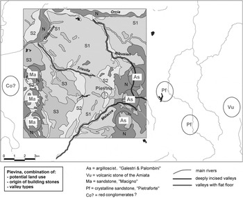
Fig. 17. Soil suitability, movement potential (valley types and water partings) and the approximate location (indicated by ovals) of geological materials from the locale of Pievina.
Pievina's locale is crossed by three major rivers with a torrential hydrological regime: the Ribusieri, Trisolla and Melacce. These rivers show an only slightly incised initial tract, followed by a middle tract with a steep valley, and finally a flat, large valley floor, terraces and rather steep bordering slopes. Only the Trisolla lacks a deeply incised tract. The slightly incised valleys would be easy to cross, the steep and deep valleys almost impossible to cross and to follow lengthwise, and the valleys with floors rather easy to cross and to follow lengthwise.
It follows from these considerations that the Ribusieri valley, with its deep incision and almost north–south direction, is a likely obstacle to the east. The Melacce river had a similar effect in the southeast, although its central and southwest valley was flat enough to provide passage towards the Ombrone. The Trisolla valley is less of an obstacle to the north as it is not incised very deeply. The Ombrone and Orcia valleys, with their braided river pattern, are seasonably fordable but probably not every year.
Thus, movement from Pievina to the northwest and southwest would be relatively easy, directions where the land units suggest suitable cropland. Movement east is more challenging, and land in this direction less suitable for agriculture. The forested slopes of Monte Amiata, however, provide other kinds of resources, and Pievina sits on the only natural route to the east (marked by the modern Cinigiano/Monticello road; see above, p. 100). Movement east thus might be less difficult and more attractive than is obvious from the topography alone, and Pievina's inhabitants might have benefited from either access to or control over east–west movement.
STONE BUILDING MATERIAL (AA) (Fig. 17)
As part of the effort to understand rural inhabitants' relationship with their locale (see above), all geological materials found on the site were traced to possible sources. The results were overlaid on the results of the topography and movement potential study (see above) to assess the priorities and challenges in the construction of the dwellings of various periods. The following were noted.
(a) The most frequent building stone is a bluish to light grey fine-grained silicious limestone, sometimes marly, with calcite veins and rather easy to work. When angular in form, this stone was quarried from the hard and compact layers of the complex of argilloscists (‘galestri’) and siliceous limestones (‘palombini’), an undated Flysch formation from the Secondary period (Fig. 17, ‘As’). When in the form of decimetre-sized rounded cobbles, the most likely find-spots are the beds of the larger rivers (Orcia, Ombrone), which actually carry stones of that size.
Minimum distance from the site c. 2 aerial km, to the east; river cobbles 8–10 aerial km.
Context used: Structure A, Structure B, wall 1503; Structure D has river cobbles.
(b) Less frequent is a very friable volcanic stone, rich in whitish transparent minerals and other inclusions. This derives from the ‘ignimbrites’ of the acidic Monte Amiata volcanic complex, dated to the Early and Middle Pleistocene (Fig. 17, ‘Vu’). It can be described as a generally tuffish-conglomeratic with angular elements.
Minimum distance from the site c. 12 aerial km, to the east.
Context used: Structure B.
(c) Less frequent is a friable yellow sandstone with small white transparent micaeous inclusions. This derives from the ‘Serie Toscana’ of the Tertiary period. They are described as sandstones and sand-schists, and are known as ‘macigno’ (Fig. 17, ‘Ma’). Generally they are not used as building material, since they are too friable.
Minimum distance from the site c. 6.5 aerial km, to the west.
Context used: Structure B.
(d) Rare is a hard reddish grey crystalline sandstone. This may be derived from the quartz-calcareous sandstones of the ‘pietraforte’ type (Fig. 17, ‘Pf’). In the field we found this formation to be only of a dark grey colour.
Minimum distance from the site c. 5 aerial km, to the east.
Context used: Structure B.
(e) Very rare is a strongly weathered grey volcanic tuff with large white leucite-crystals. This stone probably belongs to the leucite bearing lavas of the Vulsini volcanic complex, the closest known outcrop of which is near Orvieto, at a distance of c. 55 km. According to Antonelli, Napi and Lazzaroni (Reference Antonelli, Napi and Lazzaroni2001) and Peacock (Reference Peacock1980), in Roman times this stone was used widely in Italy for carving millstones.
Minimum distance from the site c. 60 aerial km.
Context used: post-hole 1557, reused as a prop.
(f) A fine-grained, hard, light-coloured, tending to layered conglomerate, locally dark reddish (Fig. 17, ‘Co’). The origin of this stone was not located definitively, but may lie in a travertine-conglomerate formation west of Poggi and Volpaia. A similar stone was viewed by the author in the San Genesio excavation (Università di Siena–Pisa), where it was used as a (flat round) millstone. At Pievina, where it was found reused in the kiln (2003) and Structure B walls, it also may have been used originally as a millstone, as it was shaped on one side.
Minimum distance from the site 10 aerial km, to the west.
Context used: Structure B (1501), Structure C.
DISCUSSION
The excavations at Pievina have demonstrated that relatively small surface scatters can be excavated successfully at speed, that geophysical survey in this environment can predict accurately the location and morphology of features as small as post-holes, and that the absence of modern deep-ploughing in this region may translate to well-stratified remains with good faunal, ceramic and even numismatic collections. The excavations were most successful, however, at questioning a number of preconceptions both we, and the discipline, held about the functional categorization of peasant sites, their morphology, land use and economies.
SURFACE SURVEY AND FUNCTIONAL CATEGORIZATION
The surface survey revealed agglomerated, discrete scatters of late Republican date, and a smaller number of more concentrated scatters of late antique date. The earlier site was thus identified as a ‘village’ with possible kiln, and the late antique site as a ‘house’ or ‘farm’. The excavations suggest that both of these designations are at best oversimplifications. A more sophisticated interpretation is hampered, however, by our having excavated only a percentage of the total surface scatters.
Only 7.5% of the late Republican site (of a scatter area of c. 4,450 m2) was excavated: the excavated scatters revealed a possible cistern, a possible granary, an ephemeral exterior hearth and a kiln site. That is, the multiple clusters of surface ceramic material and geophysical anomalies, interpreted as the detritus of multiple forms of the same kind of spaces — peasant houses —, were found upon excavation to be several structures of distinct function, none of which was a ‘house’. Without these domestic structures, we cannot be certain if the production and storage buildings served a single-family group, or multiple family groups. The four unexcavated surface concentrations may represent these houses, or they may be further service buildings.
Similarly, the discrete late antique scatters that were labelled ‘house’ or ‘farm’ were revealed to be a (probably) contiguous site with a single, small structure (Structure D) and no functional outbuildings. The discrete surface scatters (some 3,250 m2) were largely produced not by Structure D (only some 80 m2), but by the tens of square metres of beaten earth surfaces that surrounded it.
The identification of Structure D as a ‘house’ is also somewhat problematic. No installations associated with cooking or sleeping were found. Eating is the principal ‘domestic’ activity documented through ceramics and faunal remains, while cooking is attested secondarily through the large assemblage of cooking-wares. ‘Site 9’ (near Luni) and Monte Forco similarly lacked such installations, but were identified as houses on the basis of their ceramic assemblages. Much ink has been spilt on the material footprint of the ‘domestic’ (Yanagiasako, Reference Yanagiasako1979; Wilk and Rathje, Reference Wilk and Rathje1982; Blanton, Reference Blanton1994; Allison, Reference Allison1999). What ought to concern us here is not whether or not these structures can be labelled as ‘houses’, but rather the likelihood that ‘house’ may be an unhelpful functional category, as ‘domestic’ functions such as cooking, eating and sleeping might take place in the now-broadened range of site types that dotted the countryside, from the late Republican agro-industrial installation to the tiny mixed-construction building of the fifth century ad, and among a range of groups from families to artisans or labourers.
While the inaccuracies of field survey as a heuristic tool have been much discussed, most of that discussion has centred on the problems of visibility and recovery. Attributed function is rarely interrogated, largely because so few scatters have been excavated fully to test functional attributions. Site function has major implications — for demographic models that presume scatters represent habitations, and for models of Roman peasant agriculture that largely ignore surplus storage and artisanal production as major site categories.Footnote 22 The Pievina excavations sound a note of caution around functional attributions, suggesting a much wider range of functional categories than supposed heretofore. It may be that gridded surface collection and concomitant attention to the micro-topography of ceramic classes (not carried out here) might reveal these distinctions, but given the problems of residuality and the poly-functional nature of most ceramics, probably only open-area excavation provides a reliable solution. However, our own experiences show the limits even of excavated data. In retrospect, the site was too large for the time allotted, and our inability to excavate every scatter and its surrounds limited our ability to make decisive, alternative statements about function.
SITE MORPHOLOGY AND COMPARANDA
The morphology of Roman-period small farms in central Italy is known poorly. Most of the few excavated sites are considerably larger than Pievina, and typically classified as ‘villae rusticae’.Footnote 23 The few excavated (and published) examples that roughly parallel Pievina in size — the second- to first-century bc, 10 × 11 m, two-roomed structure with a forecourt and exterior dolium at ‘Site 9’ near Luni; the Augustan 11 × 5 m single-roomed building with an exterior dolium and later post-built addition at Monte Forco in the Ager Capenas; the Republican-period 20 × 10 m two-room building with a large forecourt and cistern, and the sixth-century ad post-built additions at Monte San Mario near Volterra; and the considerably larger (400–900 m2) late Republican courtyard farms near Lucca — provide some parallels, although they differ markedly in their overall morphology.Footnote 24
Since the late Republican habitation(s) at Pievina was never found, and specialized outbuildings at these other sites were few or unexcavated, Pievina looks quite different from its sister sites. All the other excavated comparanda consist of a single building, typically defined as a residence and often organized around or fronting on to a courtyard: this building typically contains in its rooms or courtyard presses, cisterns and food storage facilities. Pievina reveals another model, in which these work buildings are scattered about the site, likely some distance from the possible residence.
The late antique site at Pievina is far smaller than any of the excavated comparanda at only 4 × c. 10 m. The mere fact of the reoccupation of a small, lowland site in the early fifth century is unusual in central Italy, although some parallels may be found in the similarly ‘marginal’ region of the Val di Cecina near Volterra (Motta, Reference Motta1997). However, the site's poor, ad hoc construction techniques — such as its mixed masonry and post-built techniques, the reuse of earlier walls, irregular building geometries and the presence of pisé construction — find parallels in both high Empire examples, like Monte Forco (possibly in the second century ad or later), and late antique ones, like Monte San Mario (sixth century ad). The architectural poverty of late antique Pievina thus should not be read as symptomatic of late antiquity more generally.
CHRONOLOGY AND THE ‘IMMUTABLE’ PEASANT
The relatively good stratigraphic sequences at Pievina, combined with attention to depositional histories, suggest a rapid process of construction, abandonment and refurbishment. The stratigraphic sequences in the hearth and the more ambiguous reuse of millstones in Structure B both suggest late Republican installations with short use-lives. The thin abandonment layers in Structure D, combined with the subtle changes in African red slip ware supply, likewise suggest that the late antique ‘house’ (Phases 2.1–2) was occupied for a short time before it was replaced by the repaving and dumping episodes of Phases 2.3–4. The African red slip ware and coin sequences suggest that these changes could have taken place within as little as 30 years or less, or as long as 60. These results, along with the catastrophic landslide that separated the two major phases, tentatively describe population(s) in constant flux, modifying their production, storage and habitations in generational or sub-generational time.
This is a somewhat different scenario to that typically envisioned for peasant life-ways, presumed since Chayanov's ground-breaking study to be characterized by unchanging permanence, both in economic strategy and settlement (Chayanov, Reference Chayanov1966; Blanton, Reference Blanton1994; Schwartz and Falconer, Reference Schwartz, Falconer, Schwartz and Falconer1994). Immutability also has been thought to characterize Roman peasants, whose settlement and subsistence patterns often have been presumed to have retained pre-Roman characteristics, the principal change being the imposition of Roman tax regimes and, in late antiquity, their disappearance (for example: Wightman, Reference Wightman1978; Lloyd, Reference Lloyd, Barker and Lloyd1988; Hodges, Reference Hodges and Randsborg1989; Finley, Reference Finley1999; Wickham, Reference Wickham, Lavan and Bowden2003; Wickham, Reference Wickham2005). Other work has cast some doubt over both the evidentiary nature of ‘permanence’ in the archaeological record (Osborne, Reference Osborne1991; Foxhall, Reference Foxhall2000) and the theoretical likelihood of mobility and volatility as a base condition of ancient rural life (Horden and Purcell, Reference Horden and Purcell2000: 275; Witcher, Reference Witcher2006a). Likewise, the evidence from Pievina illustrates that the broad chronologies suggested by surface survey conceal rapid changes in site morphology and function, as well as more long-term volatility produced by a highly localized ‘natural disaster’.
LANDSCAPES AND LOCALE
The land units survey attempted to provide two lenses on peasant/landscape interaction: the mapping of geological building resources document actual interventions in the landscape, while the combined data from soil, hydrology, topography and faunal analysis provide more hypothetical pictures of potential interventions. Together these perspectives provide a glimpse of the inhabitants' ‘locale’.
The maps of the find-spots for building stone describe two very different moments of landscape exploitation. In the late Republican period, Structure B made use of five types of stone ranging from a minimum distance of two aerial kilometres to twelve or more, and much further by foot. These stones lie in both high and low movement potential areas, from the relatively inaccessible areas at the foot of Monte Amiata, where the volcanic material and sandstones were probably gathered, to the relatively more accessible light-grained limestones and yellow sandstones to be found to the west of the site. How so many different stones of radically different origins came to the site is interesting to contemplate: rather than a single trip for the explicit purpose of gathering stone for building, we might envisage the slow accumulation of stones culled over many trips to different areas, during which stone was either quarried or appropriated from other structures. This gradual accumulation might have been carried out by the denizens of Pievina, or by the denizens of another, earlier site, itself reused by Pievina's inhabitants. In any case, this scenario suggests that the collection of building stone was folded into other activities — such as shepherding, trading or social visits — that took inhabitants to these various areas. Movement in the late Republican locale, in short, was wide-ranging and multilayered, and activities were probably ‘bundled’ (cf. Fitzjohn, Reference Fitzjohn2007).
The late antique inhabitants, by contrast, exploited much closer and consistent resources, in the form of river cobbles from the distant (8–10 km) but readily-accessible Orcia and Ombrone river-beds to the north and northwest. The socles of Structure D were built wholly of these cobbles, as were the drains, pointing to a very different, possibly more focused, mode of collection aimed at these river sources, and in keeping with the relatively short duration of the site.
More hypothetical pictures of human/land relationships can be culled from other data. The possible granary (Structure B) and the reused millstones point to the production most likely of some kind of grain. The best soils for grain lie in the gently rolling land to the west: the site has the best visibility and surveillance potential in this direction, and these lands topographically would have been the most accessible. The disadvantage of these clayey Calcari-Vertic Cambisols is their weight and thus potential difficulty in ploughing. This, combined with the possibly smaller breed of cattle raised at Pievina, strongly indicates a September–October ploughing regime, when moisture levels were higher than in the summer but lower than in the winter, and thus a harvest probably in June.
The Monte Amiata foothills to the east of the site are more challenging to access due to steep river crossings, but important incentives existed to push past these obstacles, and the presence of volcanic Amiata stones in Structure B suggest Pievina's inhabitants did so. The generally small quantities of forest animals in the faunal collections (like deer and boar) suggest those incentives were not necessarily meat. These forests may have been a source of nuts and wood-fuel: palaeobotanical studies in progress might attest to their presence. Perhaps the most important resource to the east was the possible road that provides the only natural passage towards and through the Amiata mountains. The unexpected Volsini-complex millstones from Orvieto might have come to Pievina along this road (if they did not come from the coast via the river Ombrone), one example of the kind of incentive that would prompt the negotiation of physical obstacles.
In studies of peasant agriculture, water typically is assumed to be a resource that determines farm placement. At Pievina, local hydrology emerges as both an opportunity and a challenge. The sand/clay interface that may have helped push groundwater to the surface may have been exploited by the construction of a cistern (Structure A), and led to the creation of surface water at the western fontone. But groundwater was also a problem. The same geology that produced the groundwater source seems to have slumped and produced the landslide that covered the site in the late first century ad. The network of drains around late antique Structure D points to the urgent need to protect the site from hill run-off, while the succession of beaten earth and ceramic surfaces of this phase may have been intended as water-shedding mechanisms, as well as protection against subsidence and the erosion of the local, sticky clay.
ECONOMIES
The nature of ‘peasant economies’ has been long debated by anthropologists and economic historians. Traditional models distinguished peasant economies by the centrality of the household as an economic unit, by subsistence versus surplus production, and by reciprocal versus market, for-profit exchange (Chayanov, Reference Chayanov1966). This distinct ‘peasant economy’ has since been shown to be drawn too finely, while studies on modern economies that illustrate the centrality of reciprocal household exchange to markets, and the sophistication of small-scale financial transactions among the poor, have blurred the category even further (Wolf, Reference Wolf1966; Friedman, Reference Friedmann1980; Shanin, Reference Shanin1988; Appadurai, Reference Appadurai and Appadurai1986; Bernstein and Byers, Reference Bernstein and Byers2001; Collins et al., Reference Collins, Morduch, Rutherford and Ruthven2009).
The data on production, consumption and exchange from Pievina are most notable for the contradictory indicators they provide for peasant economic relationships — a complex of autarchy, risk-mitigation, trade and dependence (cf. Horden and Purcell, Reference Horden and Purcell2000; Witcher, Reference Witcher2006a; Groot et al., Reference Groot, Heeren, Kooistra and Vos2009). On the one hand, there is ample evidence for surplus and artisanal production. The late Republican inhabitants were probably producing surplus grain: a granary measuring 12 × 5 m would have had a maximum capacity of some 112 tonnes for wheat.Footnote 25 They also produced roof tiles: whether or not the tiles were intended solely for auto-consumption or exchanged beyond will be tested in a future thin-section study comparing the Pievina and other kiln data from materials located in the surface survey. The excavated portion of the late antique site, on the other hand, revealed no production or storage apparatus.
The problem of ‘subsistence’ (cf. Foxhall, Reference Foxhall1990; Horden and Purcell, Reference Horden and Purcell2000: 271) looks different yet again from the faunal evidence. The surprisingly high cattle numbers and high age at death suggest a preference for animals that produce work, food and secondary products, over the élite Roman diet of pig, which produces no work. The mix of species similarly points away from market-oriented production and towards risk-reduction strategies and auto-consumption (cf. Sallares, Reference Sallares1991), while butchery patterns further point towards household consumption. On the other hand, the preponderance of work cattle, even at the tiny late antique site, runs counter to claims that cattle were an unaffordable luxury for peasants who relied principally on human labour to till the soil (Jongman, Reference Jongmann1988: 152–3).
The ceramic data indicate that the inhabitants in both periods were tied to a trans-local exchange network. The majority of ceramic goods came from regional sources, including heretofore unknown regional amphora production. A certain, still unquantifiable, percentage of those ‘regional’ productions may have been sub-regional, or even local. A small percentage, however, is imported. It is most likely that all non-locally produced goods, that is, imported and regional products alike, were distributed through local or regional channels — perhaps the city of Roselle, whose roughly contemporary ceramic profile is so similar to Pievina's (cf. de Ligt, Reference de Ligt1991: 75 — who emphasized the role of the village as a distribution hub). Thus, while the products may be trans-mediterranean, Pievina inhabitants would have accessed them through more proximate exchange networks — the travelling merchant, the village or periodic market, the day-long journey to Roselle, or exchange with neighbours.
The sheer range of goods associated with the activities of cooking and eating is worthy of comment. Some twenty different functionally specific ceramic types (excluding dolia and lamps), including seven distinct kinds of cook-ware, six different kinds of plates and bowls and four different forms for holding or distributing beverages (Fig. 12), attest to a desire for and access to highly-specialized objects for cooking and eating. During late antiquity at least, this range of forms roughly parallels that at a nearby urban centre like Roselle, confounding any assumptions that inland, poor farmsteads had neither the access to, resources for, nor desire for the same kind of eating/cooking specialization. Although the late antique context studied was admittedly much larger than the late Republican, it is worth noting that, contrary to recent claims that rural sites lacked sophisticated, or even minimally functional ceramics (Ward-Perkins, Reference Ward-Perkins2005), the diversity of functional forms actually increased in late antiquity.
Also contrary to many claims of a de-monetized countryside (cf. de Ligt, Reference de Ligt1990; 1991), in late antiquity and more generally, small-value exchanges at late antique Pievina were often carried out with coins. While a small percentage of the 37 coins came from residual contexts, the majority came from late antique rubbish tips, or the Structure D abandonment/collapse levels. Nearly all are low-value AE4, bronze that was often devalued (Depeyrot, Reference Depeyrot1992: 40–6, 52–5; Burnett, Reference Burnett1987: 128, 131–2) and, as Banaji has suggested, became one of the hallmarks of poverty in late antiquity (Banaji, Reference Banaji2001). None the less, the presence of 30 low-value late antique coins (and coin fragments) at such a small site attests to the propensity for monetized exchange even among small rural households.
CONCLUSIONS
In their multiple indices for wealth and poverty, and in the glimpse they provide of a highly changeable, wide-ranging peasantry, the excavations at Pievina provide an intimation of the multifaceted lives of Roman rural dwellers. While only a portion of one site in one area of central Italy, Pievina's value lies in this picture of complexity. The general lack of excavations of small rural sites has meant that much of Roman history, particularly the study of the Roman economy, has had to make do with broad generalizations about the life-ways, demographics, economies and landscapes of some 80–90% of the population. The limited excavations at Pievina provide some sense of the complexities that lurk behind generalized notions of subsistence, mobility, settlement permanence and trade. If nothing else, they show the need for dozens of such excavations and locale studies, in all parts of the Mediterranean, if Roman rural history is to turn the next page.


