


Current research at Teotihuacan indicates that public life in the residential districts of the city revolved around neighborhood centers featuring multifunctional spaces, with temple complexes, plazas, civic buildings, and residences of inhabitants that were of higher social status than the average within any given cluster of neighborhoods. Teotihuacan's districts and wards are also termed barrios, and members of the Teotihuacan Mapping Project (TMP) defined these based on spatial proximity and degrees of similarity in the architecture of apartment compounds and the artifact assemblages recovered during surface collections (Altschul Reference Altschul, de Tapia and Rattray1987; Millon Reference Millon1973:40–41; Robertson Reference Robertson, Gallut and Peralta2005; Smith et al. Reference Smith, Chatterjee, Huster, Stewart and Forest2019). Spatial segregation in clusters of neighborhoods on the urban periphery and the presence of certain bounding walls in the urban epicenter help identify what might have been socially meaningful units that organized labor and taxation, as well as local civic, ritual, and market functions. We retain this definition of district as opposed to a larger quadripartite division of the city better termed a “quadrant” or “sector” (e.g., Manzanilla Reference Manzanilla, Charlotte Arnauld, Manzanilla and Smith2012a:65; Von Winning Reference Von Winning1987:72).
Investigations of the Proyecto Arqueológico Tlajinga Teotihuacan (PATT) are centered in a residential district located in the south of the ancient city (Figure 1). Tlajinga's separation from the rest of the city by the San Lorenzo River and its location to the south of the river, where it represents the last dense cluster of apartment compounds and other structures, make its identification as a district easier than in other cases without such clear bounding (Widmer and Storey Reference Widmer, Storey, Hirth and Santley1993, Reference Widmer, Storey, Charlotte Arnauld, Manzanilla and Smith2012). The district straddles both sides of the southern extension of the Street of the Dead, spanning Teotihuacan's two southern quadrants, but most of its structures, including those discussed in this article, are located to the west of this central artery. Primary objectives of the PATT are to understand the processes of urbanization, district and neighborhood organization, and diversity in domestic life relating to socioeconomic status in this southern urban periphery. Earlier field seasons (2012–2014) focused on residential areas and the unique form of multifamily housing at Teotihuacan known as apartment compounds, as well as on the southern extension of the Street of the Dead (Carballo Reference Carballo and Robb2017, Reference Carballo2019; Carballo et al. Reference Carballo, Hirth, Sariñana, Buckley, Mejía Ramón and Kennett2019). Fieldwork in 2019 shifted focus to a southern portion of Tlajinga's neighborhood center.
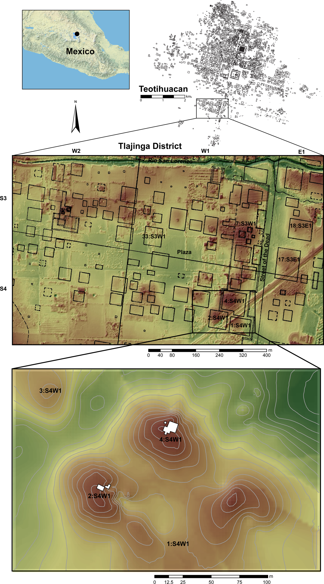
Figure 1. Location of Teotihuacan, Tlajinga district, and southern neighborhood center. Excavation areas are shaded white. (Color online)
To date, the largest, carefully executed exposures of neighborhood centers at Teotihuacan were undertaken by Rubén Cabrera Castro, Sergio Gómez Chávez, and colleagues at La Ventilla and by Linda Manzanilla and colleagues at Teopancazco (Cabrera Castro Reference Cabrera Castro1996; Cabrera Castro and Gómez Chávez Reference Cabrera Castro, Chávez, Mastache, Cobean, Cook and Hirth2008; Manzanilla Reference Manzanilla and Manzanilla2017). These investigations provide the best understanding of the social and spatial organization of districts and the centrality of neighborhood centers as nodes of urban life. Based on insights from these researchers, key elements of Teotihuacan neighborhood centers include the following: (1) public buildings that served ritual (“temple”) or administrative (“civic”) functions; (2) large open plazas between complexes and interior patios or courtyards within them capable of accommodating public or semipublic gatherings, such as marketplaces, ballgames, dances, and processions; (3) centralized food preparation and storage facilities with aligned kitchens and storerooms capable of providing food and drink during large group gatherings; and (4) residences of local nobles representing an intermediate elite within the city's social hierarchy and who were the highest ranking in a given district (Gómez Chávez Reference Gómez Chávez, Charlotte Arnauld, Manzanilla and Smith2012:81–90; Manzanilla Reference Manzanilla and Manzanilla2017:32–33). Whereas the first three elements represent clear instances of the social infrastructure of Teotihuacan's neighborhoods—areas designed for public interaction in activities that would have fostered some sense of community identity (see Klinenberg Reference Klinenberg2018; Talen Reference Talen2000)—the residences of intermediate elites, although capable of holding semipublic functions, would have reified hierarchical relations that were present in neighborhoods and the city as a whole (Manzanilla Reference Manzanilla, Charlotte Arnauld, Manzanilla and Smith2012a, Reference Manzanilla2015).
Based on existing information from neighborhoods of the city, researchers suggest that well-known Aztec corporate social groups (the calpulli or tlaxilacalli) may have their origins in Teotihuacan apartment compounds and neighborhoods. That is because these neighborhoods featured similar types of social infrastructure in public spaces and internal stratification in which commoners and elites belonged to the same group (Fargher et al. Reference Fargher, Blanton, Heredia, Nichols and Rodríguez-Alegría2017; Gómez Chávez Reference Gómez Chávez, Charlotte Arnauld, Manzanilla and Smith2012). Such an interpretation of their precursor status may prove accurate but would be bolstered by a larger sample of excavated neighborhood centers from the city, which would enable an understanding both of their social roles within the urban fabric of Teotihuacan and any of their legacies to later central Mexican civilizations. In approaching Tlajinga's neighborhood center, we were particularly interested in evaluating traces of activities associated with different structures and plazas, assessing their construction sequences and degree of architectural elaboration, and comparing them with apartment compounds at Tlajinga and neighborhood centers elsewhere in Teotihuacan. Doing so allows us to gauge how Tlajinga's neighborhood center functioned within the district and what it indicates more broadly about urban organization and status variability between the center and periphery of the city.
Field Methods
Excavations were planned in concert with community members from San Pedro Tlajinga through conversations with local stakeholders and a public event involving social mapping, where we identified areas of potential mutual interest for research that would not disrupt the rhythms of daily life in the community (e.g., Lightfoot et al. Reference Lightfoot, McCleary and Lum2014). Prehispanic Tlajinga's neighborhood center likely comprises the structures on the large platform on the western border of the Street of the Dead, spanning eastern portions of grid squares S3W1 and S4W1. To the north is a cluster of mounds mapped by the TMP as a triadic group, which could be the primary temple complex for the district; its largest mound is designated 7:S3W1. No controlled excavations have been undertaken in this area, but there is evidence of contemporary exploratory digging, and we previously registered portions of the complex using magnetometry and ground-penetrating radar (Blancas et al. Reference Blancas, Luis Barba, Guillermo Acosta, Mejía Ramón and Carballo2019).
To the south sit three large, elevated complexes, designated 1, 2, and 4 of S4W1. The center points of each are approximately 100 m apart from one another, and the area is bisected by railroad tracks, a dirt road, and the towers of overhead powerlines. Complex 4:S4W1 is topographically the highest mound in the district and measures some 50 m on a side. The fact that Complex 1:S4W1 was bisected by railroad construction accounts for its disturbed topography depicted in Figure 1, but it is also a prominent mound. Contemporary pits excavated into Complexes 1 and 4 and the dirt road crossing Complexes 2 and 4 have left portions of walls and floors exposed, which alerted us to the fact that all three are well-made structures, with their walls and floors covered in concrete and lime-stucco, as is typical of more elaborate architecture at Teotihuacan. They contrast with the apartment compounds excavated thus far at Tlajinga, which are not elevated from the ground surface and whose construction is a mix of stone and adobe walls, with scarce application of concrete and lime-stucco within their courtyards. The complexes in this southern portion of the neighborhood center therefore appeared to be of more substantial construction than typical domestic architecture at Tlajinga and may have been a possible complement to the mound group to the north centered at 7:S3W1.
Through the community-engagement events, we identified Complexes 1, 2, and 4 and open areas to the north of Complex 4 (a platform) and in the center of the district (a plaza) for study. We opened excavations at the most elevated portions of Complexes 2 and 4, explored portions of Complex 1 using remote-sensing techniques, and combined remote-sensing and auger probes in the platform and plaza area. A modern cut to the north of Complex 4:S4W1 provided a reference point for establishing an excavation grid of 2 × 2 m units oriented to the talud-tablero façade of the platform on which the complex sits. Excavations proceeded with the goals of exposing architecture to define spaces and cultural features and to uncover floors for chemical analysis.
The discovery of mural fragments in both complexes was illuminating—demonstrating the decorative elaboration of the complexes—but at the same time necessitated a slower pace for the excavations, so we could document spatial patterns of the majority of fragments found scattered in structural collapse layers and could conserve those few areas with fragments still adhering to walls. For the in situ conservation of stucco-coated surfaces, the materials used in cementing and filling were sand, sediment from the excavations, and slaked lime, with distilled water, alcohol, and 5%–7% ammonium carbonate as cleaning solvents, and sodium carboxymethyl cellulose, casein, and cellulose pulp as chemicals for other conservation processes. For a few mural fragments extracted from structural collapse, we reconnected adjoining pieces using a synthetic adhesive (Mowital, at 8%–10% xylene), because the thickness of the backing concrete (6–8 cm) required us to use a harder adhesive than lime. All architectural remains were consolidated and reburied at the conclusion of the field season.
Architecture and Depositional Contexts at Complexes 2 and 4
Excavations were the most intensive in Complex 4 with a total sediment volume of 91.4 m3, whereas the exposure in Complex 2 was roughly one-third of this volume at 30.2 m3. In both cases, we uncovered portions of interior patios or courtyards with surrounding structures. Because Complex 4 has a larger exposure, the layout of structures in it is clearer (Figure 2). Here, a central patio is surrounded by two structures to the east and south, with a probable third one to the west, where we did not excavate. Given that the external wall to the basal platform of the complex is located less than 4 m from the northern limit of the excavations, there would not be space for another structure to the north similar in size to those that were uncovered. Extrapolating from the excavated sections, the patio should therefore have a total area of 64–80 m2. This is approximately half the area of primary patios at compounds such as Tetitla (ca. 125 m2) and less than one-quarter of the largest primary patio at La Ventilla's neighborhood center (ca. 400–450 m2; Manzanilla Reference Manzanilla2006:Table 1; Murakami Reference Murakami, Tsukamoto and Inomata2014:Table 2.1). Nevertheless, it is approximately twice the area of patios in non-elite compounds, such as Tlamimilolpa and Oztoyahualco 15B, and could have accommodated some 100 spectators following extrapolations for plaza and patio capacity assembled by Murakami (Reference Murakami, Tsukamoto and Inomata2014). The patio's positioning at the edge of Complex 4 may indicate that it served as a secondary open space within the complex, similar in size to the second-largest examples at Tetitla and Zacuala, and that a larger one could be located elsewhere in unexcavated parts of the complex.

Figure 2. Planview and profile illustrations of excavation at Complex 4:S4W1. (Color online)
The structure east of the patio was designated Structure 4A; it the most fully excavated, and we documented two earlier construction phases below it. Whereas the front talud walls of Structure 4A were preserved to a height of 1 m, the front staircase and floors of the central axis were partially destroyed after the structure's abandonment. Being close to the modern surface, the final floor was also largely stripped away, and our excavations instead exposed the floor of the penultimate construction phase, Structure 4A-sub. This substructure featured a mix of stone and adobe construction; a grid of construction cells or box-and-fill walls made of adobe and uncut stone was erected on top of the penultimate floor to raise the living surface for the final structure on top of the earlier one. Several of the walls depicted in Figure 2 are therefore not internal partitions for Structure 4A-sub but rather are construction cells built after its disuse, serving to elevate the floor surface for Structure 4A.
Structure 4B is the designation for the building to the south of the patio. It is more elaborately built and decorated than Structure 4A-sub. Facing the patio is a complete talud-tablero façade and two steps leading to a portico, whose walls have mural fragments preserved in situ. Behind the portico is a room with other preserved mural fragments. Most fragments were likely associated with Structure 4B and were encountered in the patio at the corner of Structures 4A and 4B. Their motifs and potential symbolism are discussed later in the article. Other deposits of note include fragmented incense burners found in the approximate center of the patio (Feature 49) and two cache deposits at the east (Feature 44) and south (Feature 46) axes of Structure 4A (Figure 3). The incense burners were found in the fill of a postcollapse intrusive pit that may have seen the removal of a central altar from the patio. They include fragments of a stone sculpted Old God of Fire (Huehueteotl in Nahuatl) and of a ceramic composite censer. A fragment with the left hand and knee of the Old God sculpture was discovered on the patio floor a few meters to the east of Feature 49, indicating that the effigy was broken and its pieces distributed around the patio during or after abandonment of the complex. Both types of incense burners were widely used throughout Teotihuacan and are consistent with the practice of ritual activities within this northern patio of Complex 4. Another large ceramic fragment from Feature 49 was part of a fine-gray ware cup likely imported from southern Puebla or Oaxaca (Figure 4b).

Figure 3. Excavation at Complex 4:S4W1 with associated features and finds indicated (artifact illustrations by Pedro Cahuantzi Hernández; photos courtesy of the Proyecto Arqueológico Tlajinga Teotihuacan). (Color online)

Figure 4. Artifacts recovered from excavations in Complexes 2 and 4: (a) polished, outcurving bowl diagnostic of the Late Tlamimilolpa phase; (b) fragment of incised fine-gray ware cup, possibly from Oaxaca or southern Puebla; (c) Macana Red-on-Brown tripod vessel with negative decoration and interior crosshatching, diagnostic of the Mazapan phase; (d) small dish with central nubbin and spiral pattern, diagnostic of the Mazapan phase; (e) corner of sculpted grinding stone; (f) partially handmade figurine fragment; (g) fully mold-made figurine fragment; and (h) fragment of a whistle (illustrations by Pedro Cahuantzi Hernández).
Feature 46 is a cache deposit located at the center of the south wall of Structure 4A-sub. The complete miniature vessels and single-chamber candeleros from the feature are consistent with a Late Tlamimilolpa phase (AD 250–350) interment; the majority of associated sherds (59%) are from this phase designation, but there is also significant (27%) representation from the subsequent Early Xolalpan phase (AD 350–450). Therefore, we interpret the deposit and associated substructure as dating to late in the Late Tlamimilolpa phase or in the transition to Early Xolalpan in the mid- to late fourth century (see Carballo et al. Reference Carballo, Hirth, Sariñana, Buckley, Mejía Ramón and Kennett2019:Table 1, Figure 12, for radiocarbon assays from elsewhere in Tlajinga).
Feature 44 is a large, square, clay-cemented stone box that was constructed on top of Structure 4A-sub, likely as a consecration offering made during the construction of Structure 4A. The fill within the box and mounded up immediately around it was a very intentionally placed, homogeneous sand that is atypical in the stratigraphy of Teotihuacan. One of the most abundant materials in the offering were shell beads, with a majority of these made from spiny oyster (Spondylus spp.) from the Pacific Coast (Figure 3). Combined with the sand fill, the presence of shell beads could mean that the offering held aquatic symbolism, as appears to have been the intent in an offering from Teopancazco's neighborhood center, where Ortiz (Reference Ortiz Butrón2015:163) excavated a pit offering just west of the central patio filled with layers of fine sand and shell (see also Manzanilla Reference Manzanilla2012b:493). Nevertheless, another major class of offering in Feature 44 at Tlajinga were small square beads made from minerals, including polished iron ore and pyrite. The iron ore beads are not yet geologically identified but display ferromagnetism when hung from a string and introduced to a common magnet, possibly indicating they are magnetite rather than hematite. Both minerals are relatively rare as lapidary material at Teotihuacan and elsewhere in Tlajinga (Gazzola Reference Gazzola, Gallut and Peralta2005; Widmer Reference Widmer2019:Table 1). Other contents of the offering were sheets of mica and disarticulated bone. The largest bone fragments were of a human femur and partial mandible, whereas the rest were small and splintered. High ash concentrations associated with the bone could indicate that they were redeposited from a cremation, but this possibility requires further study. A majority (38%) of the associated ceramic sherds correspond to the Xolalpan phase (AD 350–550): we would place Feature 44 somewhere in the middle of this phase, during the mid-fifth century.
In considering the possible functions of Structures 4A and 4B and of their adjoining patio, it is worth noting that we encountered no subfloor burials typical of residences at Teotihuacan during the excavations. Although the few bone remains from Feature 44 may represent redeposition of a burial, they would make up a small fraction of a complete individual. Notable features typical of residences are grinding tools such as manos and metates. We did recover one corner piece of a sculpted metate from Complex 4 (Figure 4e), but this class of artifact was relatively scarce: their rarity is inconsistent with food-production activities within the patio group. Metates with sculpted motifs on the sides could have also been used for grinding pigments used in mural painting, as suggested by Séjourné (Reference Séjourné1966:217–218), or future microbotanical study could show evidence for pigment grinding, as Zurita Noguera and colleagues (Reference Zurita Noguera, Azúa, Galicia, Yrízar and Morales2013) documented at the Teopancazco neighborhood center.
Excavations at Complex 2 were more limited than at Complex 4, but in uncovering a portion of an intermediate-sized patio or courtyard, we discovered a comparable spatial context in an adjacent structure whose walls were decorated with murals, the documentation of which also slowed the pace of excavation. Only portions of an eastern building (Structure 2A) and earlier construction underneath it (Structure 2A-sub) were excavated, including exposure of part of the entrance steps, frontal portico, and interior room of the Structure 2A (Figure 5). The few wall segments uncovered in Structure 2A-sub were of nicely made adobe bricks covered in smoothed clay. They represent interior walls, rather than the cruder adobe construction cells used in raising the floor from Structure 4A-sub to Structure 4A. Architectural changes in the transition from substructure to final occupation indicate that in both Complexes 2 and 4 the early construction stages, in having a mix of stone and adobe walls and no clear signs of mural art, were less elaborate than the final ones. The tops of walls are visible in the road that traverses Complex 2 to the south–southeast of the excavations, indicating the presence of another structure to the south of the documented patio.

Figure 5. Planview and profile illustrations of excavation at Complex 2:S4W1. (Color online)
An outcurving bowl of polished monochrome ware was discovered, along with a fragment of a human cranium, as a cache offering (Feature 48) associated with Structure 2A-sub (Figures 4a and 6). As with the ceramics in Feature 46 of Structure 4A-sub, the vessel is diagnostic of the Late Tlamimilolpa phase (AD 250–350) and suggests that the two structures were generally contemporaneous. Another offering coupling pottery vessels and human bone was found on the final floor of the patio, but it represents a later reoccupation of the area during the Mazapan phase (AD 850–1050). The assemblage consists of a tripod bowl (Figure 4c), a flat-bottomed bowl, and a small plate or coaster (Figure 4d), all three of which are decorated. The tripod is a Macana Red-on-Brown vessel with interior decoration in negative and incised crosshatches on the basal interior, consistent with use as a molcajete for grinding chiles or making salsa. The same types of vessels were found by Manzanilla and colleagues (Reference Manzanilla, López and Freter1996:250) in the anthropogenic caves behind the Sun Pyramid that are associated with radiometric dates spanning the eighth to tenth centuries. This dating is also consistent with radiocarbon assays on bone and wood from an intrusive Mazapan burial, also accompanied by vessels, from Complex 17:S3E1 at Tlajinga (Carballo et al. Reference Carballo, Hirth, Sariñana, Buckley, Mejía Ramón and Kennett2019:Table 1). It is further evidence of rural occupation at Tlajinga during the Terminal Corral and Early Tollan phases of the Toltec capital of Tula.

Figure 6. Excavation at Complex 2:S4W1 with associated features and finds indicated (photos courtesy of the Proyecto Arqueológico Tlajinga Teotihuacan). (Color online)
Mural fragments were concentrated in the interior room of Structure 2A where they were exceedingly dense. Most were recovered on top of a red-painted stucco floor in the small (ca. 1.2 × 1.0 m) exposure excavated within the interior room. A large wall was built directly on top of the red floor that covered some mural fill, indicating it clearly postdates the destruction of the mural. We encountered no evidence for the last floor of the occupation, but because it is so close to the modern surface, we imagine that there was one that has since eroded away. If that is correct, the northern wall of this room would be from a penultimate construction phase and was likely ripped out for the final construction, which we infer both from the later wall's superposition on the red floor and from a neat cut at the floor line of the earlier red floor where the stucco curled upward to meet the now-destroyed wall. The missing wall may then have been the source of the mural fragments after acts of purposeful destruction and interment between the penultimate and final construction stages.
We also encountered mural painting directly on one large adobe on top of the red floor of the interior room and on a large, nicely cut, rectangular stone block found facedown in the portico (Figure 6). This block has part of a frieze of painted green disc-beads termed chalchihuites in Nahuatl and used by the Aztecs in decorating more elaborate buildings and in purposeful archaisms that index elaborate buildings at Teotihuacan (López Luján and De Anda Rogel Reference López Luján and Rogel2019). The overseer of Rancho Tlajinga, whose property the excavation area sits on, informed us that a large, cut-stone block with part of a sculpted frieze of discs motifs was encountered during agricultural work on top of Complex 1:S4W1; it is now in the possession of the ranch owner. We can therefore extrapolate that all three complexes of Tlajinga's southern neighborhood center contained elaborately made and decorated structures.
Geophysical Studies
Magnetic-gradient studies were undertaken in two gridded blocks to the north and south of the excavations, providing additional information about architectural alignments on the northern platform and at Complex 1:S4W1 (Figure 7). The geophysical survey grid on the platform measured 60 × 20 m and covered an area where community members and, occasionally, archaeologists gather to play soccer on an informal pitch. The magnetic gradient map documents dipoles suggesting the subsurface presence of partial stone alignments, yet none form closed rooms or demarcated structures. It is therefore possible they represent supporting walls underneath the upper floor of the platform, now mostly eroded, or they could be from insubstantial structures on top of the platform. Alternatively, they may have moved downslope from the west where prospection documented thicker wall alignments that likely correspond to Structure 11:S4W1 designated by TMP surveyors. Excavations are required to clarify these relationships.

Figure 7. Areas mapped by magnetic gradient, including the platform north of Complex 4:S4W1 and the center of Complex 1:S4W1, indicated in white on the topographic map. Hypothetical wall alignments are indicated in black. (Color online)
The geophysical survey grid on top of Complex 1:S4W1 measured 40 × 40 m, with an eastern segment of 20 × 10 m unanalyzed because of surface disturbances. The prospected area revealed subsurface walls of different sizes with some alignments well defined as rooms, whereas the organization of other spaces was obscured by accumulated structural debris. To the center-south of the area is what looks to be a patio with dimensions (approximately 15 × 15 m or 225 m2) exceeding the primary patios of apartment compounds such as Tetitla, Atetelco, and Yayahuala, but about half the size of the largest at La Ventilla's neighborhood center (Manzanilla Reference Manzanilla2006:Table 1; Murakami Reference Murakami, Tsukamoto and Inomata2014:Table 2.1). Future excavations are needed to verify the spatial organization of the complex, but the prospection suggests similarities to those encountered in excavations at Complexes 2 and 4.
Chemical Residues in Floors
At the conclusion of the excavations in Complex 4, 56 samples of floor surfaces were taken from the two construction episodes (Figure 8) and analyzed using the methods and experimentally derived interpretive frameworks described by Barba (Reference Barba2007; see also Carballo et al. Reference Carballo, Barba, Ortiz, Blancas, Cingolani, Barrera, Walton, López and Couoh2014; Ortiz et al. Reference Ortiz Butrón, Pecci, Barba and Manzanilla2018; Pecci et al. Reference Pecci, Barba and Ortiz2017). Samples from Substructure 4A-sub (n = 18) displayed an absence of fatty acids and low values of phosphates, protein residues, and carbohydrates. They only registered relatively high values for pH and intermediate to low values for carbonates. In earlier studies at Teotihuacan, we observed a correlation between high values of pH and carbonates due to the slight alkalinity of the carbonates themselves. For 4A-sub, the carbonate values are much lower than expected (registering 1 or 2), given the high values of pH (registering between 9 and 9.4). This raises the possibility that the high pH might originate from hydroxides derived from ash. The low values of phosphates, protein residues, and fatty acids negate the possibility of floor signatures consistent with cooking activities. It is nevertheless possible that other activities deposited ash on the floor, such as burning in incense burners or braziers. Whatever the origins of the high pH value, the low values of other chemical markers are inconsistent with the structure's use as a residence, at least in those rooms that were sampled.

Figure 8. Maps depicting sample locations and intensities of certain chemical compounds from Structure 4A-Sub1 (top) and Structure 4B, with its associated patio (bottom) from Complex 4:S4W1. (Color online)
Structure 4B represents the subsequent and final construction episode at the complex, and samples (n = 38) were taken from its frontal patio, portico, and interior room. They exhibit a clear difference from those from Substructure 4A-sub in registering higher values of chemical residues, yet they also do not exhibit signatures consistent with intensive food production or other domestic activities. The upper floors of Structure 4B have nicely preserved lime plaster over typical Teotihuacano concrete and register intermediate values of carbonates (between 2 and 3) and high values of pH (between 8.61 and 9.80).
Although these values exhibit a closer correlation than at Substructure 4A-sub, alkalinity of the carbonates alone cannot account for the very high saturation of pH documented in the interior room of Structure 4B and in three spots within the patio. The high values of pH registered for Structure 4B and the patio could instead suggest burning, as has been documented in other areas of Teotihuacan, especially associated with its political collapse and termination of the city. Nevertheless, no macroscopic evidence of burning on the floors was observed during excavations, making ash deposits from ritual activities involving ceramic receptacles a more likely contributor to the registered values (Ortiz et al. Reference Ortiz Butrón, Pecci, Barba and Manzanilla2018:109). This possibility is bolstered by the pieces of incense burners that were recovered from the excavations (Figure 3).
Mural Symbolism
In addition to the lines of evidence gathered from architectural, artifact, and chemical distributions, the motifs and symbolism in the recovered mural fragments provide important information regarding elaboration of the complexes relative to other parts of Tlajinga and of the city. They could also shed light on the possible social significance of these spaces and corroborate other lines of evidence regarding activities undertaken within them. Analysis of the iconography and pigmentation of mural fragments is ongoing, but several general observations can be made regarding their quality and the themes represented. Motifs discovered in situ in the portico and interior room of Structure 4B share thematic similarities to others found in Teotihuacan's urban epicenter (Figure 9). Among these are murals from a complex at the foot of the Sun Pyramid, either called the Palace of the Sun, Zone 5A, or by its grid designation of 13:N4E1 (Figure 9h). Murals from Portico 13 and Room 13 in this complex feature scenes of birds with song scrolls, volutes of “water” scrolls, butterflies, and four-petaled flowers (de la Fuente Reference de la Fuente and de la Fuente2001:70–74; Magaloni-Kerpel et al. Reference Magaloni-Kerpel, O'Neil, Uriarte, Hirth, Carballo and Arroyo2020:199–205; Miller Reference Miller1973:80–82). The central figure in the Portico 13 murals is a Net Jaguar, whereas that of the Room 13 mural is the celestial Great Bird being shot down by blowgun, known from pan-Mesoamerican mythologies (Nielsen and Helmke Reference Nielsen and Helmke2015). Other larger central figures from the Tlajinga 4B mural remain unclear.
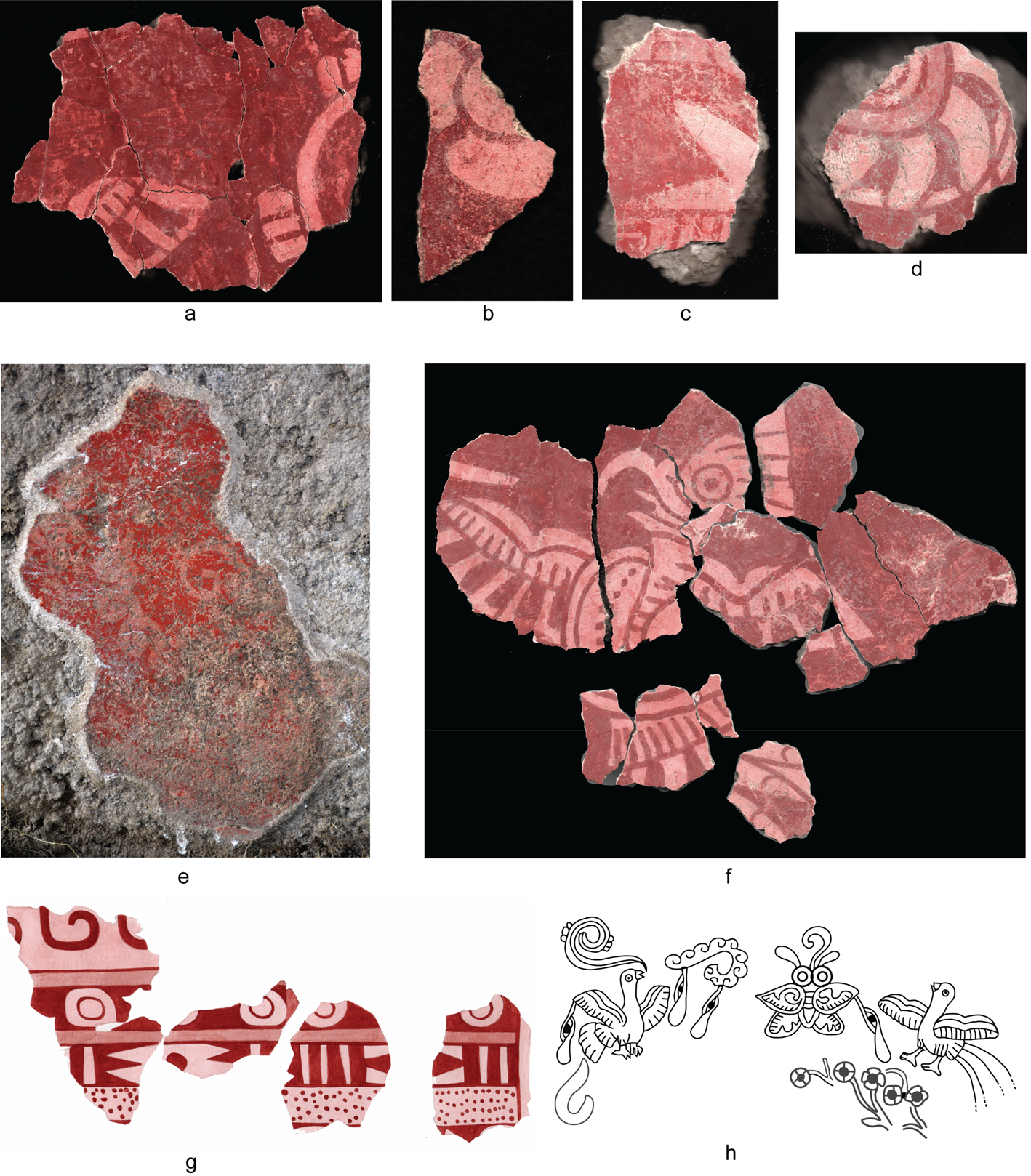
Figure 9. Mural fragments from Complex 4:S4W1: (a–d, f) fragments found in structural collapse; (e) fragment found adhering to portico wall of Structure 4B (photos courtesy of the Proyecto Arqueológico Tlajinga Teotihuacan); (g) illustration of articulated fragments with geometric motifs with fire and water symbols by Pedro Cahuantzi Hernández; (h) elements from Palace of the Sun or Zone 5A mural in Portico 13, depicting similar themes to those above (redrawn from Miller Reference Miller1973:Figure 116). (Color online)
Fragments of at least two birds were recovered, the most complete of which features a combination of a hooked beak tip and plumage mixing a speckled upper interior wing and striped lower interior wing (Figure 9f). These could be attributes indexing black hawk-eagles (Spizaetus tyrannus) as proposed for bird depictions in other murals of Teotihuacan (Navarijo Ornelas Reference Navarijo Ornelas and de la Fuente2001:331). There is at least one claw motif in the collection, as well as star elements (Figure 9c) like those depicted in the Zone 5A Portico 13 mural and in one from Room 13; other pieces, however, are too fragmentary or ambiguous to match presently. Nevertheless, the backdrop seems consistent with depictions of a Teotihuacano paradise featuring birds, butterflies, and flowers seen in murals from Atetelco, the Palace of the Sun, and Tepantitla and in other imagery from the city, which may have symbolized a glorious afterworld for warriors, women who died in childbirth, or others who died for valiant causes (Helmke and Nielsen Reference Helmke, Nielsen and Robb2017:132–133).
Geometric bands from Complex 4 feature sequential motifs identifiable as water scrolls and rhomboid elements; they are separated by vertical lines known from the braziers of the Old God of Fire to represent that fundamental element, between which are disc motifs (Figure 9g). The coupling of water and fire bands is seen on other murals at Teotihuacan, such as at the Totometla compound, and it represents a clear precursor to the well-known Aztec difrasismo, or metaphoric couplet, atl-tlachinolli (“the water, the burning”; Juárez Osnaya Reference Juárez Osnaya2014:248–259). The couplet is often glossed in English as “water-fire” or “burning water.” It was a pan-central Mexican concept in the sixteenth century, shared by Nahuas and Otomis, and was associated both with war and a fundamental creative force (Séjourné Reference Séjourné1976:99–110; Wright Carr Reference Wright Carr2012). If the band of disc motifs between the water and fire bands represents jade beads, as is often interpreted, it may convey a sense of “precious” or “sacred” burning water (teoatltlachinolli; see Angulo Villaseñor Reference Angulo Villaseñor and de la Fuente2001:77)—perhaps, a precious war or creation.
Mural fragments from Complex 2 feature a feathered eye as a dominant motif, and there are a dozen or more individual elements of these encountered from an area of only approximately 2 m2 (Figure 10). Other motifs include lattice-like triangles with curling interior lines, discs, stars, and vertical lines. Green lattice and disc motifs are present on murals from Room 12 at Tetitla, and the green feathered eye is seen on depictions of birds or bird-headdresses at that compound and elsewhere, as well as on a depiction of the Storm God on the temple-shaped altar in Atetelco's central patio (Miller Reference Miller1973:147, 151, 164–165). The feathered eye is also seen on the murals of Techinantitla, both embodied on the Feathered Serpent and various birds and disembodied as a glyphic element on one of the flowering trees (Berrin Reference Berrin1988). Langley (Reference Langley1986:249–251) records four variants of feathered eye signs, with those from the Tlajinga Complex 2 mural unlike any of them in all details (see also Urcid Reference Urcid, Nichols and Pool2013:856–863). None matches the particular combination seen in Tlajinga Structure 2A where the eyes are fully disembodied (Figure 10a, Figure 10d), are not clearly part of the glyphic compound, and are positioned among the green lattice and scrolls. It is possible that the larger composition featured feathered eyes within a diagonal lattice, somewhat like mural 2 of Portico 25 at Tetitla, which features depictions of full birds between diagonal lattices. Alternatively, those from Complex 2 at Tlajinga could represent stylized icons of birds, perhaps quetzals because of their green plumage, and the central curve in the scroll motifs is iconic of a curled wing (Figure 10c), as seen in full depictions of birds elsewhere in the city's art (Navarijo Ornelas Reference Navarijo Ornelas and de la Fuente2001:335; Javier Urcid, personal communication 2020).

Figure 10. Mural fragments from Complex 2:S4W1 (photos courtesy of the Proyecto Arqueológico Tlajinga Teotihuacan). (Color online)
Conclusion
The 2019 excavations in Tlajinga's southern neighborhood center provide a better understanding of the social organization of this southern district of Teotihuacan and how its inhabitants articulated with the broader city. Recent investigations at Teotihuacan have illuminated the centrality of districts and neighborhoods to its urban fabric and the ways in which social inequality among these could be muted relative to other Mesoamerican cities in some domains yet still prevalent in others (Carballo Reference Carballo, Hirth, Carballo and Arroyo2020; Manzanilla Reference Manzanilla2006, Reference Manzanilla, Charlotte Arnauld, Manzanilla and Smith2012a, Reference Manzanilla2015, Reference Carballo and Robb2017; Smith et al. Reference Smith, Dennehy, Kamp-Whittaker, Colon and Harkness2014, Reference Smith, Chatterjee, Huster, Stewart and Forest2019). Contemporary urban studies underscore how public buildings and open spaces promote community formation and neighborhood resilience in ways that seem congruent with what we are learning archaeologically about Teotihuacan. To cultivate the social interactions that foster a sense of community, public spaces should be well distributed within cities so that, for instance, civic architecture does not cluster in their center or green spaces in their periphery (Talen Reference Talen2000). The distribution of civic architecture with functions and symbolism that encourage a sense of community makes such spaces accessible to a wider range of the urban populace. Similarly, if urban public spaces are created to serve as accessible places where people can gather and enjoy the activities they engage in, they create a social infrastructure that strengthens bonds between community members, making neighborhoods with such spaces more resilient in times of crisis (Klinenberg Reference Klinenberg2018). These implications from global urban studies are supported by comparative analyses of prehispanic cities from highland Mexico, where Fargher and colleagues (Reference Fargher, Heredia Espinoza and Blanton2011) document a correspondence between more collective rule and the presence of public spaces and civic buildings at the neighborhood or district level.
New fieldwork at Tlajinga adds to our understanding of such issues by revealing portions of a neighborhood center featuring large, elaborately made, and decorated platform complexes on the urban periphery. Although situated more than 2 km from the Teotihuacan's epicenter, among dozens of apartment compounds made from simpler construction techniques and decorated minimally if at all, Complexes 1, 2, and 4 of S4W1 stand out as more elaborate, elevated platforms with masonry construction techniques and mural and sculptural adornments characteristic of buildings in the city center. Likewise, offering deposits such as Feature 44 contain long-distance trade items—particularly beads made from iron ore and spondylus shell—with relatively restrictive distributions within Teotihuacan's artifact inventories. In conjunction with finds from Tlajinga reported earlier (Carballo et al. Reference Carballo, Hirth, Sariñana, Buckley, Mejía Ramón and Kennett2019), they attest to the wide circulation of commodities within Teotihuacan's economy and the fact that residents of the urban periphery enjoyed access to nicer things.
Mural themes, especially those encountered at Complex 4, appear to convey ultimate-sacred propositions (sensu Rappaport Reference Rappaport1971) or high-level meaning (sensu Rapoport Reference Rapoport and Poyatos1988) within Teotihuacano cosmology. Their symbolism conveyed themes of powerful creative forces and a paradisical afterworld, perhaps linked to politico-religious notions of warfare and a social contract of expected duties in return for some level of affluence and social mobility between the Teotihuacan state and its residents. The iconography of the murals, their association with patios or courtyards of an intermediate size, and little documentation of the subfloor burials, chemical residues, and food-production tools such as made from ground stone all support a working hypothesis that the excavated portions of Complexes 2 and 4 served semipublic functions.
It is important to emphasize that all three platform complexes may have also had residential components for intermediate elites of the district; yet these are not apparent from portions we have thus far excavated and chemically analyzed. Still, a residential role for the complexes would not be at odds for their also having served semipublic functions: this coupling of roles is known from Teotihuacan and elsewhere in highland Mesoamerica (Carballo Reference Carballo2011; Evans Reference Evans, Evans and Pillsbury2006; Manzanilla Reference Manzanilla, Charlotte Arnauld, Manzanilla and Smith2012a). Further material analyses will provide other lines of evidence on which to base interpretations to clarify these relationships. Ritual incense burners encountered in the patio of Complex 4 are suggestive of this excavated context having served as a ceremonial space, though it also may have served functions associated with socialization and learning, known from Aztec neighborhood centers.
Taken together, these new investigations demonstrate that the complexes of Tlajinga's southern neighborhood center would have provided components of the social architecture of the district, as would the northern neighborhood centered around 7:S3W1 and the open platforms and plazas between and west of these two areas, which would have accommodated larger public gatherings. Although the Tlajinga district's primary inhabitants were non-elites, these more elaborate complexes are suggestive of clear connections with the city's politico-religious hierarchy. Their location along the southern extension of the Street of the Dead means that various buildings of the complexes would have been visible to people entering the city from the south along this central artery, making them the public and “street-facing” part of the district and indexing the local community's ties to the urban built environment of Teotihuacan as a whole.
Acknowledgments
The investigations reported in this article were made possible by the financial support of the H. and T. King Grant for Precolumbian Archaeology of the Society for American Archaeology and by Luis Octavio Ruzo, to whom we are greatly appreciative. We thank the inhabitants of San Pedro Tlajinga and the Consejo de Arqueología and Zona Arqueológica de Monumentos de Teotihuacan, INAH, for their logistical and administrative support of the project. Jorge Archer, Citlali Coronel, Jesper Nielsen, David Wright Carr, Javier Urcid, and Maria Teresa Uriarte provided helpful suggestions regarding mural iconography, as did George Bey for Mazapan ceramics. Madeline Ray and Genessis Guzman assisted with the community social mapping before fieldwork began. We dedicate the article to the memory of Pedro Cahuantzi Hernández, whose skilled hand drew the artifact illustrations and whose companionship on this project and others is greatly missed.
Data Availability Statement
Data presented in this article, as well as from earlier seasons of the PATT, can be accessed in technical reports available on the project's page in the Digital Archaeological Record (tDAR), https://core.tdar.org/project/440550/tlajinga-teotihuacan-mexico. Other resources are available on the project webpage, http://sites.bu.edu/patt/.


