INTRODUCTION
Precise age models are of paramount importance for paleoclimatic and paleoenvironmental reconstructions based on marine sediment cores. This is especially true when correlating signatures of climate oscillations to external forcing mechanisms such as solar irradiance or Milankovitch cycles. Tephrochronostratigraphy is an effective dating method because ash layers can be cross-correlated between all types of sedimentary environments including terrestrial, marine, and lacustrine archives (e.g., Keller et al., Reference Keller, Ryan, Ninkovich and Altherr1978; Paterne et al., Reference Paterne, Guichard, Labeyrie, Gillot and Duplessy1986; Wulf et al., Reference Wulf, Kraml, Brauer, Keller and Negendank2004; Kutterolf et al., Reference Kutterolf, Freundt and Peréz2008, Reference Kutterolf, Schindlbeck, Anselmetti, Ariztegui, Brenner, Curtis, Schmid, Hodell, Mueller and Pérez2016; Neugebauer et al., Reference Neugebauer, Wulf, Schwab, Serb, Plessen, Appelt and Brauer2017). Furthermore, in the Mediterranean, tephroanalysis on historical time scales bears minimal temporal uncertainty compared with other common dating methods (accelerator mass spectrometry [AMS] 14C dating), because historic documentation exists for major eruptions of the past ~2000 yr (e.g., Arnò et al., Reference Arnò, Principe, Rosi, Santacroce, Sbrana and Sheridan1987). The Gulf of Taranto provides an ideal setting for high-resolution paleoclimatic studies (Taricco et al., Reference Taricco, Alessio and Vivaldo2008, Reference Taricco, Ghil, Alessio and Vivaldo2009, Reference Taricco, Vivaldo, Alessio, Rubinetti and Mancuso2015; Zonneveld et al., Reference Zonneveld, Chen, Elshanawany, Fischer, Hoins, Ibrahim, Pittauerova and Versteegh2012; Goudeau et al., Reference Goudeau, Grauel, Bernasconi and de Lange2013, Reference Goudeau, Grauel, Tessarolo, Leider, Chen, Bernasconi, Versteegh, Zonneveld, Boer and Alonso-Hernandez2014) because it is especially susceptible to both climate variability and human-induced changes in land use, eutrophication, and pollution on the Italian mainland. High amounts of nutrients and suspended sediments from the Po and other Italian rivers are transported northwest to southeast along the Adriatic coast and result in unusually high sedimentation rates in the Gulf of Taranto. Its location downwind of the highly explosive Italian volcanic province suggests the use of tephrostratigraphy to accurately date marine sediment cores (Fig. 1C). Several eruptions of Mt. Vesuvius, the Phlegrean Fields, the Eolian Islands, and the Palinuro seamount have emplaced pronounced distal tephra layers in this region (e.g., Siani et al., Reference Siani, Sulpizio, Paterne and Sbrana2004; Wulf et al., Reference Wulf, Kraml and Keller2008). However, in contrast to thick ash deposits from the eastern Mediterranean Sea that are identifiable by distinct color and grain-size changes (e.g., Guichard et al., Reference Guichard, Carey, Arthur, Sigurdsson and Arnold1993; Kuzucuoglu et al., Reference Kuzucuoglu, Pastre, Black, Ercan, Fontugne, Guillou, Hatté, Karabiyikoglu, Orth and Türkecan1998; Wulf et al., Reference Wulf, Kraml, Kuhn, Schwarz, Inthorn, Keller, Kuscu and Halbach2002), there are no macroscopically visible tephra layers in the uppermost sediments of the Gulf of Taranto most likely because there were no eruptions during the past several hundred years that were strong enough to transport large amounts of pyroclasts (e.g., Goudeau et al., Reference Goudeau, Grauel, Tessarolo, Leider, Chen, Bernasconi, Versteegh, Zonneveld, Boer and Alonso-Hernandez2014; this study). Macroscopic tephra recognition in distal marine or lacustrine sediments as well as soils and ice cores gets more difficult farther away from the source because particle size and amount diminish with distance (Lowe and Hunt, Reference Lowe and Hunt2001). These “hidden” distal tephras (Dugmore, Reference Dugmore1989) have been named cryptotephras (from the Greek word kryptein, meaning “to hide”) and are a relatively new focus for tephrochronological studies in northern Europe, Scandinavia, New Zealand, and elsewhere (e.g., Davies et al., Reference Davies, Branch, Lowe and Turney2002, Reference Davies, Wohlfarth, Wastegård, Andersson, Blockley and Possnert2004, Reference Davies, Elmquist, Bergman, Wohlfarth and Hammarlund2007; Turney et al., Reference Turney, Lowe, Davies, Hall, Lowe, Wastegård, Hoek and Alloway2004; Wohlfarth et al., Reference Wohlfarth, Blaauw, Davies, Andersson, Wastegård, Hormes and Possnert2006; Pyne-O’Donnell et al., Reference Pyne-O’Donnell, Cwynar, Vincent, Spear and Froese2014; Neugebauer et al., Reference Neugebauer, Wulf, Schwab, Serb, Plessen, Appelt and Brauer2017). When concentrated in horizons, they can provide valuable insights into eruptive histories as well as significant marker horizons in distal environments where distinct layers are absent.
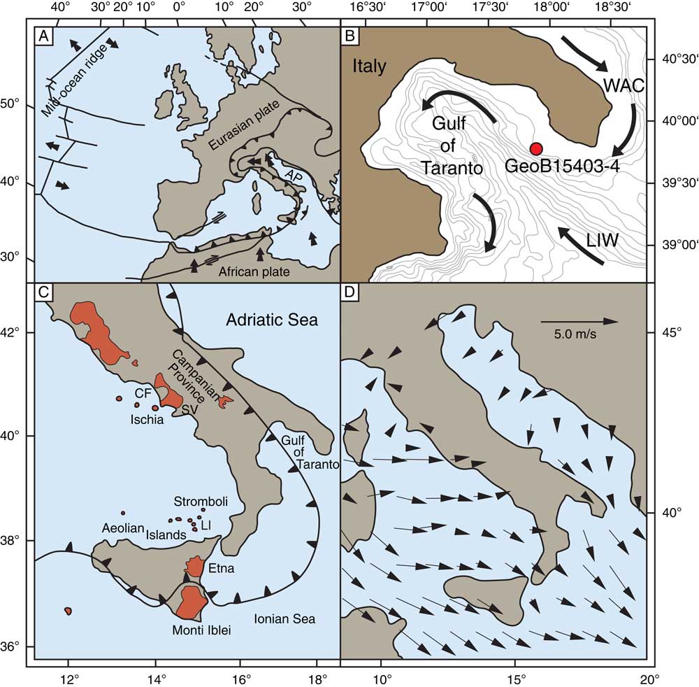
Figure 1 (A) Tectonic overview of the central Mediterranean and adjacent areas (modified after Grünthal und Stromeyer, Reference Grünthal and Stromeyer1992). (B) General circulation and dominant water masses of the Gulf of Taranto and location of gravity core GeoB15403-4 (bathymetry from http://www.gebco.net). LIW, Levantine Intermediate Water; WAC, West Adriatic Current. (C) Italian volcanic provinces (orange) with the Phlegraean Fields (CF) and the Somma-Vesuvius (SV) (modified after D’Antonio et al., Reference D’Antonio, Tilton and Civetta1996). (D) Annual average surface wind direction and strength over the study area (May, Reference May1982). (For interpretation of the references to color in this figure legend, the reader is referred to the web version of this article.)
In the recent past, some authors have microscopically counted the number density of pyroxene grains in sediments from the Gulf of Taranto and aimed at identifying tephra layers and their source eruptions solely based on ash particle abundance (e.g., Castagnoli et al., Reference Castagnoli, Bonino, Caprioglio, Provenzale, Serio and Guang‐Mei1990; Bonino et al., Reference Bonino, Castagnoli, Callegari and Zhu1993; Taricco et al., Reference Taricco, Ghil, Alessio and Vivaldo2009). Pyroxene minerals crystalize within the magma chamber (Schmincke and Sumita, Reference Schmincke and Sumita2013) and can be transported with other pyroclastic material over long distances (Paterne et al., Reference Paterne, Guichard and Labeyrie1988), so peaks in pyroxene grain abundance have been used in the past to tune the sediment record to historical eruptions of the Campanian area. Although this may be a promising first assessment for tephra abundance, it bears a high degree of uncertainty because pyroxene grains (1) can be reworked, (2) can be derived from several eruptions simultaneously, and (3) can usually not be allocated to specific eruptions by petrographic features alone, or (4) a hiatus in the sediment record can lead to a pyroxene peak being assigned to the wrong eruption. Instead, geochemical fingerprinting of glass shards is a widely used tool to confidently identify the source of ash deposits (e.g., Lowe, Reference Lowe2011; Schindlbeck et al., Reference Schindlbeck, Kutterolf, Freundt, Alvarado, Wang, Straub, Hemming, Frische and Woodhead2016; Neugebauer et al., Reference Neugebauer, Wulf, Schwab, Serb, Plessen, Appelt and Brauer2017), even when using their major element compositions alone (Zanchetta et al., Reference Zanchetta, Sulpizio, Roberts, Cioni, Eastwood, Siani, Caron, Paterne and Santacroce2011).
In this study, we present a continuous microprobe analysis of glass shards from high-resolution stratigraphic samples of the uppermost 50 cm of a sediment core from the Gulf of Taranto (Fig. 1B). Furthermore, we determine the glass shard abundance within the background sediment to evaluate the nature and systematics of the cryptotephra in a semiquantitative-compositional approach. The combination of quantitative determination of glass shard abundance and geochemically based fingerprinting of the respective glasses allows for a reliable correlation of tephra layer(s) to eruptions in this region. This provides an additional stratigraphic framework for further paleoclimatic studies.
GEOLOGIC AND ENVIRONMENTAL SETTING
Italy is a highly geodynamic region because of its location on the active plate boundary where both the African plate and the Apulian microplate are being subducted under the Eurasian plate (Fig. 1A), leading to frequent earthquakes and the only currently active volcanoes in mainland Europe (e.g., D’Antonio et al., Reference D’Antonio, Tilton and Civetta1996; Wortel and Spakman, Reference Wortel and Spakman2000). Numerous explosive eruptions of the Italian volcanic province have been recorded throughout the Quaternary (Paterne et al., Reference Paterne, Labeyrie, Guichard, Mazaud and Maitre1990; Keller et al., Reference Keller, Kraml and Scheld1996; Beccaluva et al., Reference Beccaluva, Bianchini, Bonadiman, Coltorti, Milani, Salvini, Siena and Tassinari2007; Bourne et al., Reference Bourne, Lowe, Trincardi, Asioli, Blockley, Wulf, Matthews, Piva and Vigliotti2010; Tomlinson et al., Reference Tomlinson, Smith, Albert, Aydar, Civetta, Cioni, Çubukçu, Gertisser, Isaia and Menzies2015). During the Holocene, some of the most active areas were the Phlegrean Fields including the island of Ischia, the Somma-Vesuvius, the Etna on Sicily, and the Aeolian Islands with the volcanoes Lipari, Grande Vossa, and Stromboli (Fig. 1C). The eastward flowing subtropical jet modulates large-scale atmospheric circulation patterns over the study area influencing the transport of eruptive material carried to 10 to 20 km height by plinian and subplinian eruptions (Newhall and Self, Reference Newhall and Self1982; Dee et al., Reference Dee, Uppala, Simmons, Berrisford, Poli, Kobayashi, Andrae, Balmaseda, Balsamo and Bauer2011). Observational data show that the predominant wind direction close to the surface is northwest to southeast, following the large-scale circulation (Fig. 1D) (May, Reference May1982) resulting in a preferentially southeastward dispersal of pyroclastic material as evident in several tephra layers found in marine sediment cores from the central and eastern Mediterranean Sea (Paterne et al., Reference Paterne, Guichard and Labeyrie1988, Reference Paterne, Labeyrie, Guichard, Mazaud and Maitre1990; Barberi et al., Reference Barberi, Macedonio, Pareschi and Santacroce1990; Keller et al., Reference Keller, Kraml and Scheld1996; Zanchetta et al., Reference Zanchetta, Sulpizio, Roberts, Cioni, Eastwood, Siani, Caron, Paterne and Santacroce2011). Similar dispersal pathways are also predicted in model data and observed in historic eruptions (e.g., Costa et al., Reference Costa, Macedonio and Folch2006). The Gulf of Taranto, located at the southern tip of Italy in the central Mediterranean Sea, is positioned southeastward of the Italian volcanic arc. The primary water masses controlling the oceanography in the Gulf of Taranto are (1) the West Adriatic Current (WAC) fed by suspension-rich freshwater from the Po River before moving counterclockwise along the western Adriatic coastline into the gulf (Lipizer et al., Reference Lipizer, Partescano, Rabitti, Giorgetti and Crise2014) and (2) the Levantine Intermediate Water, which enters the basin from the Levantine Sea at depths between 200 and 600 m (Turchetto et al., Reference Turchetto, Boldrin, Langone, Miserocchi, Tesi and Foglini2007) (Fig. 1B). Because of high nutrient content and suspended loads, relatively high sedimentation rates between 0.52 mm/yr to 2.81 mm/yr have been reported for the shallow eastern Apulian shelf, making it a favorable location for high-resolution climate change studies (e.g., Zonneveld et al., Reference Zonneveld, Chen, Elshanawany, Fischer, Hoins, Ibrahim, Pittauerova and Versteegh2012; Goudeau et al., Reference Goudeau, Grauel, Bernasconi and de Lange2013) that are in need of precise age models.
MATERIAL AND METHODS
Core sampling and sediment composition
The gravity core GeoB15403-4 (39°45.42′N, 17°53.53′E; 170 m water depth) was recovered from the eastern Apulian shelf in the Gulf of Taranto during the R/V Poseidon cruise 411 in April 2011 (Fig. 1B). The 5.245-m-long core was sampled at 2.5 mm resolution with the present study investigating the uppermost 50 cm at a 1 cm sampling space. Maximum oxygen penetration depth was identified by distinct color changes at 6 cm. This is consistent with maximum oxygen penetration observed in multicores from the same station, suggesting negligible sediment loss during core recovery. Freeze-dried sediment samples were wet sieved, and the 63–125 µm fraction was dried at 40°C for tephroanalysis. This fraction has been demonstrated to be the most promising for getting analyzable tephra particles from primary eruptive events (e.g., Kutterolf et al., Reference Kutterolf, Freundt and Peréz2008; Schindlbeck et al., Reference Schindlbeck, Kutterolf, Freundt, Alvarado, Wang, Straub, Hemming, Frische and Woodhead2016).
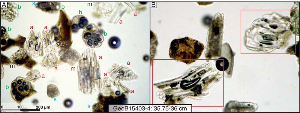
The investigated core interval consists of homogenous, nannofossil-rich grayish to green mud with an undisturbed sediment surface and abundant particles in the fine-sand fraction. Sediment in the coarser fraction consists of sedimentary lithic clasts; biogenic particles such as foraminifers, gastropods, pteropods, bivalves, and sponge spicules; siliciclastic components including quartz, feldspar, pyroxene, amphibole, biotite, and spinel; and varying amounts of pyroclasts in the form of transparent and brownish and highly vesicular transparent glass shards (Fig. 2A and B).

Figure 2 Microscopic photographs of the ash horizon at 35.75–36 cm in GeoB15403-4, showing the abundance of ash particles (red “a”) in comparison with biogenic clasts (green “b”), sedimentary lithics (blue “s”), and minerals (black “m”) (A) and the appearance of pumiceous, highly vesicular glass shards with tubular bubble structures (B). (For interpretation of the references to color in this figure legend, the reader is referred to the web version of this article.)
Analytical techniques
We analyzed glass shards from the grain-size fraction 63–125 µm of 50 sediment samples with an electron microprobe (EMP) for major and minor elements following the procedure of Kutterolf et al. (Reference Kutterolf, Freundt and Burkert2011) (Supplementary Table 1). EMP analyses were conducted on epoxy-embedded and polished samples with a JEOL JXA 8200 wavelength dispersive EMP at GEOMAR, Kiel, using 15 kV accelerating voltage, a beam defocused to 5 µm, with a beam current of 6 nA and counting times of 30 to 60 s for most major elements and 60 to 100 s for the minor elements. Natural and synthetic glasses and minerals were used as standards for calibration. Accuracy was monitored by standard measurements on Lipari obsidian (rhyolite) (Hunt and Hill, Reference Hunt and Hill2001) and Smithsonian basaltic standard VGA. This is commonly used as VGA and refers to Basaltic glass sample A-99 Makaopuhi Lava Lake (Supplementary Table 2). When available, 15 glass shards were measured per sample by scanning throughout the entire epoxy-embedded sample area. After every 60 individual measurements, 2 to 4 standard measurements (always 2 for the Lipari standard, and if mafic glass was identified, also 2 for the VGA standard) follow to verify the stability of the measuring program. The resulting standard deviation is <0.5% for major and <3% for most minor elements (Supplementary Table 3). All analyses were normalized to 100% to eliminate the effects of variable postdepositional hydration and minor deviations in the electron beam focus. Because variable submarine alteration (Kutterolf et al., Reference Kutterolf, Freundt, Perez, Wehrmann and Schmincke2007) causes elemental exchange at the surface and rims of single glass shards first (e.g., Schacht, Reference Schacht2005), microanalyses aimed at the center of glass shards.
For a semiquantitative estimation of pyroclast abundance, we point counted the 63–125 µm fraction of each sample that comprised more than 14 glass shards identified by microprobe analysis (Supplementary Table 4). We used a regular net on top of the respective BSE (Backscattered electron) pictures of each analyzed sample to create a grid. Particles that intersected the grid were categorized as glass shard or nonglass shard. If the intersection targeted epoxy, no point was counted. At least 400 points were counted to derive a statistically significant estimation (e.g., Van der Plas and Tobi, Reference Van der Plas and Tobi1965) of respective volume percentages of the pyroclast and nonpyroclast fractions. Samples including fewer than 10 glass shards were identified during EMP work and were not counted. Based on the point counting results of samples where only 14 glass shards were identified during EMP work, and which account only for 1 to 1.5 vol%, these samples were estimated to contain less than 1 vol% of glass shards.
AMS 14C–based age model
For the establishment of an AMS 14C–based age model for GeoB15403-4, we selected surface-dwelling planktonic foraminifera from a total of 11 samples along the core (Table 1). Dating was performed at Beta Analytic Inc. (Miami, FL, USA). Radiocarbon dates were converted to calendar years using the MARINE13 database (Reimer et al., Reference Reimer, Bard, Bayliss, Beck, Blackwell, Ramsey and Buck2013) with a Delta R value of 73±34. Delta R was calculated using the MarineChrono reservoir database through an interpolation of data points close to the core locations.
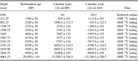
Table 1 Results of the accelerator mass spectrometry (AMS) 14C dating of planktonic foraminifera in GeoB15403-4.

RESULTS
Geochemistry
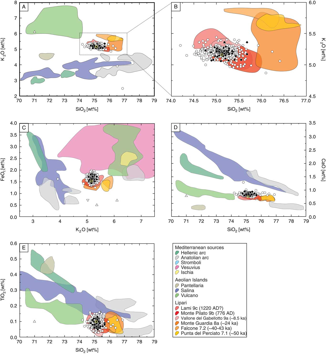
Major element analysis of 503 glass shards revealed contributions of minor basaltic/andesitic and trachyte-basaltic, as well as major rhyolitic magmatic, compositions to the sediments (Fig. 3A). In Figure 3, the glass shard compositions are plotted with provenance fields of Mediterranean volcanic arcs and in particular with compositional fields of eruptions from the Aeolian Islands for comparison. All analyzed glass shards fall within the potassium-rich high-K calc-alkaline series or the shoshonitic series (Fig. 3B).
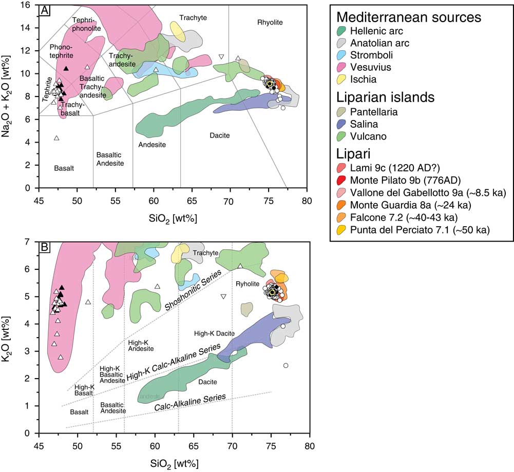
Figure 3 (A) Total alkalis versus silica diagram after Le Maitre et al. (Reference Le Maitre, Dudek, Keller, Lameyre, Le Bas, Sabine, Schmid, Sorensen, Streckeisen and Woolley1989) showing the compositional variability of all analyzed samples, with circles/diamonds representing felsic compositions in all samples, triangles showing mafic compositions limited to the first 15 cm bsf (below sea floor), black being the inferred primary cryptotephra layer around 36 cm bsf, and white being the glass shard composition of all other samples. (B) K2O versus SiO2 classification diagram (Peccerillo and Taylor, Reference Peccerillo and Taylor1976) for the volcanic rocks of Lipari, modified after Forni et al. (Reference Forni, Lucchi, Peccerillo, Tranne, Rossi and Frezzotti2013). Glass compositions are normalized to anhydrous compositions. Reference field based on data from Forni et al. (Reference Forni, Lucchi, Peccerillo, Tranne, Rossi and Frezzotti2013), Albert et al. (Reference Albert, Tomlinson, Smith, Di Traglia, Pistolesi, Morris, Donato, De Rosa, Sulpizio and Keller2017), and Tomlinson et al. (Reference Tomlinson, Smith, Albert, Aydar, Civetta, Cioni, Çubukçu, Gertisser, Isaia and Menzies2015). (For interpretation of the references to color in this figure legend, the reader is referred to the web version of this article.)
The majority of the investigated glass shards cluster at potassium concentrations >4 wt% with SiO2 contents of 47 wt% or 75 wt%, respectively (Figs. 3B, 4A, and 5A). Very few exceptions (5 out of 503 glass shards) have potassium concentrations <4 wt% (Fig. 3B). The majority (~95%) of the glass shards have a rhyolitic composition and have major element concentrations that cluster around 13 wt% Al2O3, 4 wt% Na2O, 1.5 wt% FeOt, 0.7 wt% CaO, and 0.1 wt% TiO2 (Fig. 5; Supplementary Table 1). The tephritic to trachy-basaltic glass shards, concentrated in the first 6 cm of the sediment, contain average compositions of ~17.8 wt% Al2O3, ~10.4 wt% CaO, ~9.5 wt% FeOt, ~4 wt% MgO, ~3.6 wt% Na2O, and ~1.2 wt% TiO2 (Fig. 4A; Supplementary Table 1).
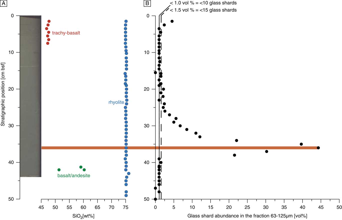
Figure 4 (A) Left: Core picture showing the undisturbed sediment structure without visible tephra layers. Right: Down-core variation in SiO2 concentration of average glass shard compositions, with red representing trachy-basalt, blue showing rhyolite, and green basalt/andesite. (B) Relative abundance of glass shards in the grain size fraction 63–125 µm derived by point counting (see “Material and Methods”). The dotted line represents samples with ≤10 (<1 vol%), and the stippled line samples with 10 to 14 (1 to 1.5 vol%) identified glass shards per sample. The horizontal bar (orange) marks the inferred primary cryptotephra layer. (For interpretation of the references to color in this figure legend, the reader is referred to the web version of this article.)
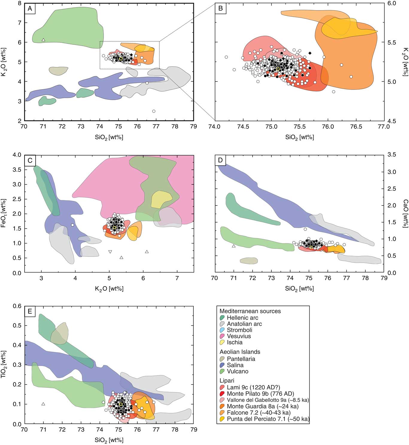
Figure 5 (A–E) Discrimination diagrams to determine the volcanic provenance of the analyzed glass shards with focus on the island Lipari. Reference fields for Mediterranean sources and eruptions from Lipari are based on the data of Forni et al. (Reference Forni, Lucchi, Peccerillo, Tranne, Rossi and Frezzotti2013), Albert et al. (Reference Albert, Tomlinson, Smith, Di Traglia, Pistolesi, Morris, Donato, De Rosa, Sulpizio and Keller2017), and Tomlinson et al. (Reference Tomlinson, Smith, Albert, Aydar, Civetta, Cioni, Çubukçu, Gertisser, Isaia and Menzies2015). Circles/diamonds represent the felsic compositions in all samples, triangles are mafic compositions limited to the first 15 cm, black is the inferred primary cryptotephra layer, and white is the glass shard composition of all other samples. Glass compositions are normalized to anhydrous compositions. (For interpretation of the references to color in this figure legend, the reader is referred to the web version of this article.)
Ash abundance
Although the brownish, trachy-basaltic, basaltic, and andesitic glass shards are limited to the uppermost 6 cm of the core, the transparent, rhyolithic glass shards occur unequally distributed throughout the entire investigated interval (Fig. 4A).
The overall abundance of glass shards within the upper 20 cm of sediment stayed below 1.5 vol%, with the exception of two samples at 1.5 cm bsf (below sea floor) (4.5 vol%) and 2.5 cm bsf (2.4 vol%) that contain trachy-basaltic–dominated glass shard compositions (Fig. 4B). Between 20 cm bsf and 36 cm bsf there is a continuous increase of glass shard abundance, exclusively of rhyolitic composition, up to 44 vol% (36 cm bsf). Between 36 cm bsf and 38 cm bsf, the tephra abundance decreases sharply back to a <1.5 vol% presence of glass shards in the sediments where it remains until the end of the investigated sediment interval (Fig. 4B).
Age model
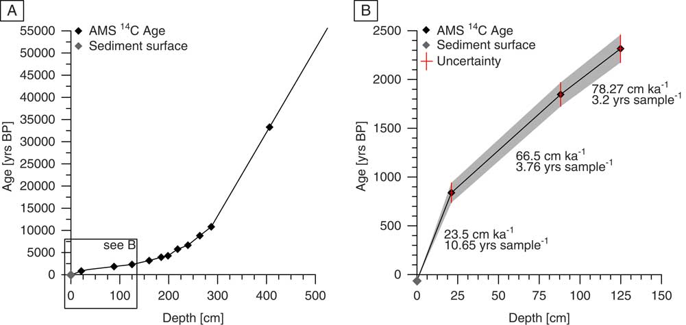
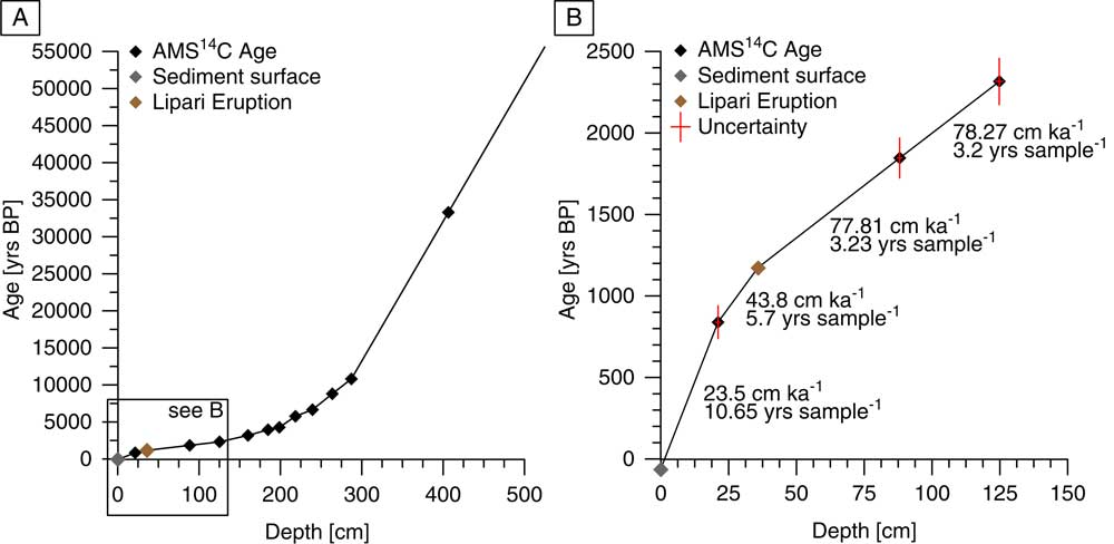
Results of the AMS 14C dating on plankton foraminifera are given in Table 1. The 14C-based age model for GeoB15403-4 was established through linear interpolation and gives an age of 55,600 yr BP for the base of the whole core (Fig. 6A). The investigated core interval (0–50 cm) has a basal age of 1305 yr BP. Sedimentation rates decrease within this section from 66.5 cm/kyr in the older part to 23.5 cm/kyr in the youngest samples (Fig. 6B).

Figure 6 (A) Results of the accelerator mass spectrometry (AMS) 14C–based age model for GeoB15403-4. Black diamonds represent AMS 14C dates, and gray diamonds show the age of the sediment surface. (B) Detailed view of the core interval investigated in this study. Horizontal red bars indicate the depth interval from which planktonic foraminifera were selected, and vertical red bars indicate 2σ uncertainties of radiocarbon ages. (For interpretation of the references to color in this figure legend, the reader is referred to the web version of this article.)
DISCUSSION
Compositional homogeneity
It is important to assess whether the observed glass shards form homogenous (only from one eruption and source) or heterogeneous (reworked from several eruptions and sources) assemblages. The overall geochemistry of the glass shards indicates very homogenous major elemental concentrations in two clusters (Figs. 3, 4, and 5). Based solely on the compositional homogeneity, we can infer that (within the limitations of investigating only one grain-size fraction) the interval between 20 and 38 cm contains a primary cryptotephra with a peak in glass shard abundance at 36 cm bsf. Only in four samples within the first 6 cm bsf can bimodal compositions be observed, whereas all other samples until 41 cm bsf show very confined homogenous rhyolithic glass shard compositions. The only exceptions are a few single outliers in three samples. These homogenous element concentrations argue for cryptotephras originating from single specific eruptions respectively, which allows for the stratigraphic assignment of historic eruptive events. Below 42 cm, the ash abundance significantly decreases and the glass shard composition is heterogeneous.
Provenance of the cryptotephras
So far, the appearance of volcanic material in the Gulf of Taranto has been attributed to volcanic eruptions based on peaks in pyroxene abundances inferred from the density variations within the sediments (e.g., Bonino et al., Reference Bonino, Castagnoli, Callegari and Zhu1993; Taricco et al. Reference Taricco, Ghil, Alessio and Vivaldo2009; Vivaldo et al. Reference Vivaldo, Taricco, Alessio and Ghil2009). The authors argue that the proximity to the Campanian volcanic region, as well as the prevailing westerly winds, provided a complete and nearly temporally linear record of the eruptive history within the sediments of the Ionian Sea. According to this and the AMS 14C–based age model of core GeoB15403-4 (Fig. 7), the observed glass shard maximum centered around 36 cm bsf should be associated with the AD 1301 Ischia eruption. The ideal test for the provenance and assignment to a specific eruption is the geochemical fingerprint analysis of volcanic glass shards. Glass shards from Ischia are less silica rich at higher alkali contents (trachytes) than the high-silica glass shards (rhyolites) in sediments below 6 cm bsf of GeoB15403-4. Comparing the compositional signals with the respective provenance fields (Tomlinson et al., Reference Tomlinson, Smith, Albert, Aydar, Civetta, Cioni, Çubukçu, Gertisser, Isaia and Menzies2015), the assignment of the observed glass shards in the upper 42 cm of core GeoB15403-4 to an Ischia eruption can thus be excluded (Figs. 3 and 5C). In the first 6 cm of the sediment core, the glass shards reveal a tephritic composition, which is also very different from the Ischia volcanic products.

Figure 7 Combined age model for GeoB15403-4. (A) Accelerator mass spectrometry (AMS) 14C and results of the tephroanalysis. Black diamonds represent the AMS 14C dates, gray dots show the age of the sediment surface, and light brown shows the ash layer assigned to the AD 776 eruption of Monte Pilato. (B) Detailed view of the core interval investigated in this study. Horizontal red bars indicate the depth interval from which planktonic foraminifera were selected for AMS 14C dating, and vertical red bars indicate 2σ uncertainties of radiocarbon ages. (For interpretation of the references to color in this figure legend, the reader is referred to the web version of this article.)
To confine the possible origin of the glass shards, we further compare the geochemical compositions of the analyzed glass shards with provenance data of the Mediterranean volcanic provinces (e.g., Keller et al., Reference Keller, Ryan, Ninkovich and Altherr1978; Tomlinson et al., Reference Tomlinson, Smith, Albert, Aydar, Civetta, Cioni, Çubukçu, Gertisser, Isaia and Menzies2015; Albert et al., Reference Albert, Tomlinson, Smith, Di Traglia, Pistolesi, Morris, Donato, De Rosa, Sulpizio and Keller2017). Already within the basic classification diagrams of Figure 3 (total alkali vs. silica, potassium vs. silica) it becomes clear that possible provenance regions are very distinct.
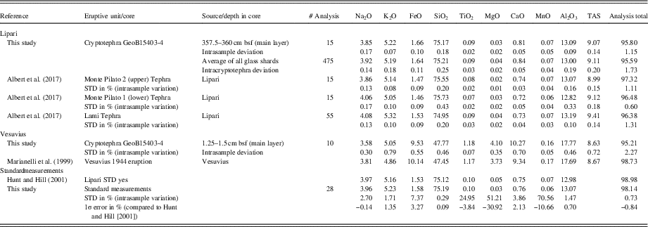
The trachytic composition of the glass shards within the first 6 cm and a peak in 1.5 cm depth bsf only fits to the Somma-Vesuvius eruptions at ages younger than 1000 yr BP (Table 2). The increase of silica-unsaturated, high-alkali glasses found in Somma-Vesuvius eruptions between AD 79 and AD 1944 is the best fit for the glass compositions of this study (Piochi et al., Reference Piochi, De Vivo and Ayuso2006; Di Renzo et al., Reference Di Renzo, Di Vito, Arienzo, Carandente, Civetta, D’antonio, Giordano, Orsi and Tonarini2007 and references therein). Additionally, according to estimated sedimentation rates of 2.5 mm/10 yr, the AD 1944 eruption bears the highest potential to be the source eruption for the glass shards at 1.5 cm bsf.
Table 2 Averaged results of the electron microprobe analysis from this study, respective standard measurements, their intrasample/standard deviations, and terrestrial reference data given in the literature for the eligible correlative Lipari deposit and the Vesuvius 1944 eruption. STD, standard deviation; TAS, total alkalis.

The geochemical fingerprint of the glass shard peak at 36 cm bsf unambiguously identifies Lipari as the source (Figs. 3 and 5). Representative compositional data from eruptions from Lipari (Albert et al., Reference Albert, Tomlinson, Smith, Di Traglia, Pistolesi, Morris, Donato, De Rosa, Sulpizio and Keller2017) and the very detailed eruptive catalogue of Lucchi et al. (Reference Lucchi, Keller and Tranne2013) reveal that only the last eruption cycle (9a, b, c) on Lipari (Lami, Monte Pilato, Vallone del Gabellotto eruptions) produced tephra glass compositions that correlate with the analyzed glass shards of core GeoB15403-4. Based on the AMS 14C age model and the derived sedimentation rate of 23.5 cm/ka for the studied core section (Fig. 7), the ~8.5 ka Vallone del Gabellotto eruption can be ruled out as the responsible source for the tephra peak at 36 cm depth bsf. In addition, the clearly defined glass shard peak and the homogenous geochemical composition contradicts reworking of a potential Vallone del Gabellotto marine ash layer.
This leaves two eruptions from Lipari as candidates for the eruptive products in the sediments: the AD 1220 Lami eruption and the AD 776 Monte Pilato eruption. Although both eruptions have very similar geochemical compositions, several arguments favor the AD 776 Monte Pilato eruption as the volcanic event that is responsible for the cryptic tephra layer in 36 cm bsf of core GeoB15403-4 (Table 2). According to our age model, an age of 1180 yr BP would be assigned to 36 cm bsf, which fits better to the uncorrected 14C age of 1241 ± 31 yr BP for the Monte Pilato eruption than an age of 780 yr BP recalculated for the AD 1220 Lami eruption. Second, the AD 1220 Lami eruption is characterized by slightly lower SiO2 and higher K2O contents than the Monte Pilato eruption, which is in accordance with the majority of the measurements from the main part of the cryptotephra layer in 36 cm bsf (Fig. 5B, black filled symbols). Third, whereas the origin and size of the AD 776 Monte Pilato eruption is well constrained (Albert et al., Reference Albert, Tomlinson, Smith, Di Roberto, Todman, Rosi, Marani, Muller and Menzies2012, Reference Albert, Tomlinson, Smith, Di Traglia, Pistolesi, Morris, Donato, De Rosa, Sulpizio and Keller2017; Forni et al., Reference Forni, Lucchi, Peccerillo, Tranne, Rossi and Frezzotti2013), the Lami “eruption” is much more controversial. It has been questioned whether the Lami deposits are assigned to the older Monte Pilato eruption (Davi et al., Reference Davì, De Rosa and Barca2009) or not (Forni et al., Reference Forni, Lucchi, Peccerillo, Tranne, Rossi and Frezzotti2013). If the glass shards in our sediments are to be associated with the Lami eruption, coinciding with the AD 1300 Rocche Rosse coulee, sedimentation rates of >45 cm/ka would be required for the upper part of core GeoB15403-4. Similar or even higher sedimentation rates have been reported from adjacent sediment cores of the Gulf of Taranto (e.g., Zonneveld and Siccha, Reference Zonneveld and Siccha2016), which leaves some uncertainty in the final assignment of the cryptic tephra at site GeoB15403-4.
The fourth argument concerns the size of the Lami and Monte Pilato eruptions. Compared with the up to 150-m-thick pumiceous pyroclastics of the Monte Pilato eruption (Forni et al., Reference Forni, Lucchi, Peccerillo, Tranne, Rossi and Frezzotti2013), the Lami eruption is only represented by a 10-m-thick pyroclastic succession. Additionally “Lami deposits” are composed of variably sorted tuff-breccias with pumices, lithic clasts, diffused obsidian clasts, and bread-crust pumiceous bombs, as well as intercalated, variably stratified, medium sorted lapilli layers and massive tuff layers (Forni et al., Reference Forni, Lucchi, Peccerillo, Tranne, Rossi and Frezzotti2013). These observations suggest that the AD 776 Monte Pilato eruption had at least a subplinian character (Albert et al., Reference Albert, Tomlinson, Smith, Di Roberto, Todman, Rosi, Marani, Muller and Menzies2012, Reference Albert, Tomlinson, Smith, Di Traglia, Pistolesi, Morris, Donato, De Rosa, Sulpizio and Keller2017), whereas the Lami succession is associated with a Vulcanian eruption at most (Davi et al., Reference Davì, De Rosa and Barca2009; Forni et al., Reference Forni, Lucchi, Peccerillo, Tranne, Rossi and Frezzotti2013; Albert et al., Reference Albert, Tomlinson, Smith, Di Traglia, Pistolesi, Morris, Donato, De Rosa, Sulpizio and Keller2017). The necessary size to inject volcanic matter high into the atmosphere, where it can be transported with the prevailing winds over long distances, is thus only given for the AD 776 Monte Pilato eruption. This interpretation is additionally supported by the occurrence of several centimeter-thick ash layers of the Monte Pilato eruption at distal outcrops on Vulcano, Stromboli, and Panera, which are located between Lipari and the Gulf of Taranto (Lucchi et al., Reference Lucchi, Tranne, De Astis, Keller, Losito and Morche2008, Reference Lucchi, Keller and Tranne2013; Bertagnini et al., Reference Bertagnini, Di Roberto and Pompilio2011). These data suggest that the AD 776 Monte Pilato eruption is the volcanic event that produced the cryptotephra found at 36 cm bsf in sediment core GeoB15403-4 from the Gulf of Taranto.
Implications for further paleoclimate studies
Paleoclimate studies of Holocene marine sediments on decadal to centennial time scales require accurate age models, which cannot always be provided solely by radiocarbon dating because of uncertainties of local reservoir effects and biological factors (e.g., habitat differences of planktonic foraminifera). In the eastern Mediterranean Sea, tephrochronology provides an additional tool for a reliable age assessment of sediment cores and allows for an optimal correlation of regional paleoclimatic events (e.g., Vinci, Reference Vinci1985). Several efforts have been made to cross-correlate Holocene tephra layers from the central and eastern Mediterranean basin (Zanchetta et al., Reference Zanchetta, Sulpizio, Roberts, Cioni, Eastwood, Siani, Caron, Paterne and Santacroce2011 and references therein). The widely distributed tephra layers of Y-5 and Y-6 (De Vivo et al., Reference De Vivo, Rolandi, Gans, Calvert, Bohrson, Spera and Belkin2001; Margari et al., Reference Margari, Pyle, Bryant and Gibbard2007; Vogel et al., Reference Vogel, Zanchetta, Sulpizio, Wagner and Nowaczyk2010) provide important marker horizons of the late Pleistocene for the central and eastern Mediterranean basin. Volcanic eruptions of the Holocene are numerous and chronically well resolved in the sedimentary record of sites proximal to the eruption centers. However, the existing tephrostratigraphic schemes are currently still disconnected (Zanchetta et al., Reference Zanchetta, Sulpizio, Roberts, Cioni, Eastwood, Siani, Caron, Paterne and Santacroce2011), and the potential of cryptotephras is not yet fully utilized. We therefore propose to include tephroanalysis as a common method when conducting paleoclimatic studies on high-resolution sediment cores from the central and eastern Mediterranean Sea.
Previous studies on pyroxene grain abundance proved useful in recording late Holocene cryptotephras in the Gulf of Taranto (e.g., Castagnoli et al., Reference Castagnoli, Bonino, Caprioglio, Provenzale, Serio and Guang‐Mei1990). However, the identification of volcanic eruptions solely based on tephra particle abundance remains ambiguous. In this context, our new results highlight the importance of geochemical fingerprinting of volcanic glass shards. The detailed chronological framework obtained from this study provides an ideal background for further paleoclimate studies conducted on the sediments of GeoB15403-4. It provides new temporal constraints for this area that have previously not been recognized and may therefore provoke revisiting of some marine sediment records of the past. This is particularly relevant for regions such as the Gulf of Taranto located downwind of several highly active volcanic provinces with numerous eruptions during the past 2000 yr. The Gulf of Taranto serves as a depositional center for Italian riverine suspension load, which is transported southward along the WAC. Thus, Holocene sediments of the Gulf of Taranto provide an excellent archive for the study of regional decadal-scale hydrologic changes and climate linkages between the Mediterranean and North Atlantic regions, given that the studied sediment cores can be accurately dated (e.g., Taricco et al., Reference Taricco, Vivaldo, Alessio, Rubinetti and Mancuso2015; Menke, V., Ehrmann, W., Milker, Y., Brzelinski, S., Möbius, J., Mikolajewicz, U., Zolitschka, B., Zonneveld, K., Emeis, K.C., Schmiedl, G., unpublished manuscript).
CONCLUSIONS
Quantitative analysis of pyroclast contents in sediment samples of gravity core GeoB15403-4 from the Gulf of Taranto identified two cryptotephras. Electron microprobe analysis indicates homogenous element concentrations allowing us to disregard potential uncertainties like sediment reworking or multiple possible eruption sources at the time of deposition.
Geochemical fingerprinting of glass shards from the upper 6 cm and the peak at 1.5 cm depth points to Somma-Vesuvius eruptions occurring before 1000 yr BP. Based on the increase of silica under saturated, high-alkali glasses of Somma-Vesuvius eruptions between AD 79 and AD 1944 and the timeframe given by our 14C-based age model, we argue for the AD 1944 eruption to be the source for this ash layer.
The pronounced peak of rhyolitic glass shards at 36 cm suggests a primary cryptotephra. Elemental composition reveals the volcanoes of the island Lipari as source. Based on the geochemical composition, the eruption type, and our 14C age model, we argue for the AD 776 Monte Pilato eruption to have emplaced this cryptotephra.
Our study shows that tephroanalysis provides an important tool for the age assessment of marine sediment cores. Specifically, geochemical fingerprinting proves to be a crucial method ensuring the correct source identification of cryptotephras. Our results will improve the stratigraphic framework for sediments from the high-accumulation areas of the Gulf of Taranto, providing the basis for decadal-scale hydrologic and paleoclimatic reconstructions.
ACKNOWLEDGMENTS
We thank the chief scientist K.A.F. Zonneveld, the master and crew of R/V Poseidon. We thank Kai Fockenberg and Mario Thöner for preparing and calibrating the microprobe measurements. This study was supported by the Deutsche Forschungsgemeinschaft, grant SCHM1180/18 and the “School of Integrated Climate System Science (SICSS)” of the Cluster of Excellence “Integrated Climate System Analysis and Prediction (CliSAP).”
Supplementary material
To view supplementary material for this article, please visit https://doi.org/10.1017/qua.2018.2