INTRODUCTION
The Aleutian Islands, Alaska, are located on the boundary of the Pacific Ocean and the Bering Sea (Figure 1). For nearly 9000 years, Aleutian peoples built villages and prospered in the eastern part of this archipelago. The climate of the Aleutians is cool to cold and supports grass and forb vegetation (tundra). During the Holocene period, soil and tephra complexes were deposited on the islands (Figure 2a; Coats Reference Coats1956). The Islands of the Four Mountains (IFM) is a group of eight volcanic islands. Herbert and Carlisle represent single volcanoes; Chuginadak comprises two volcanic cones—Tana and Cleveland—that have coalesced, forming an isthmus (Figure 1). We conducted field surveys in 2014 and 2015 to determine geological hazards, climate change, and human/ecosystems resilience in the IFM (Hatfield et al. Reference Hatfield, Bruner, West, Savinetsky, Krylovich, Khasanov, Vasyukov, Antipushina, Okuno, Crockford, Nicolaysen, MacInnes, Persico, Izbekov, Neal, Bartlett, Loopesko and Fulton2016).

Figure 1 Location of the Islands of Four Mountains (IFM). DUT: Dutch Harbor, ANC: Anchorage. Satellite image was obtained from Google Maps.

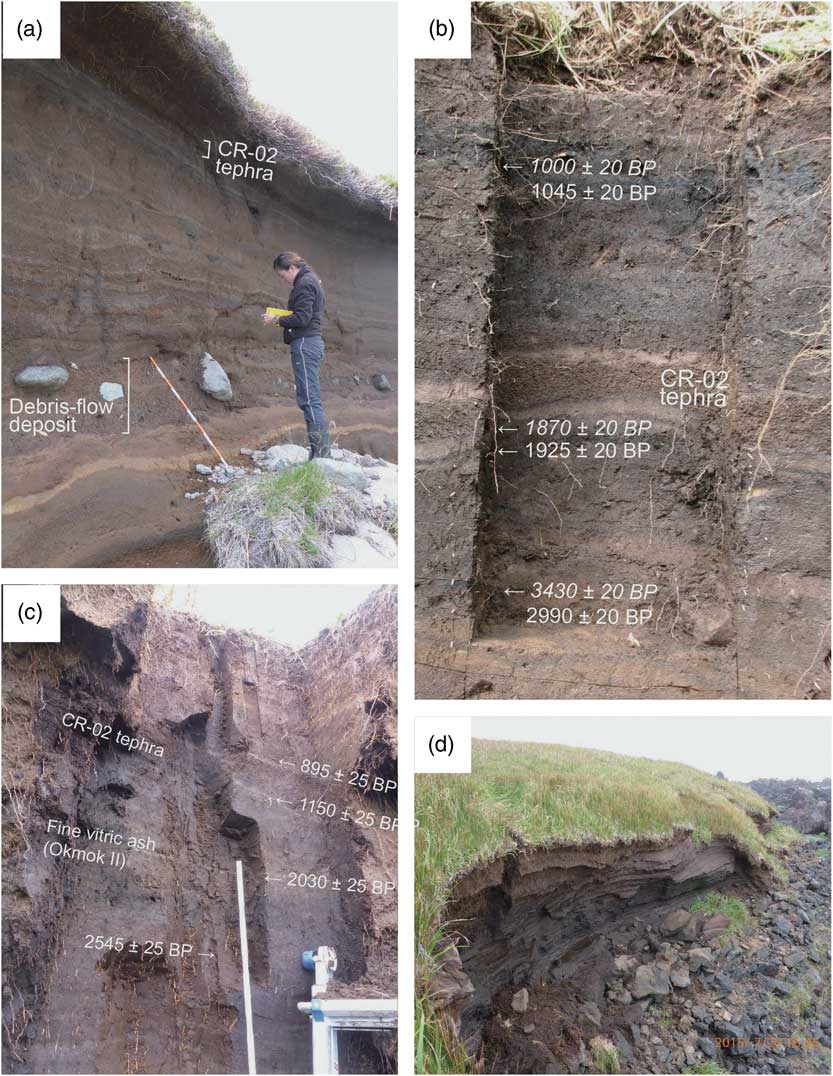
Figure 2 Photographs of the CR-02 and CR-03 sites on Carlisle Island: (a) soil and tephra complexes during Holocene Period near the prehistoric village site CR-02 (AMK-0003). A debris-flow deposit is intercalated with this complex. (b) CR-02 tephra intercalated with cultural layers in the prehistoric village site CR-02. Six 14C dates were obtained from charcoal fragments (Hatfield et al. Reference Hatfield, Bruner, West, Savinetsky, Krylovich, Khasanov, Vasyukov, Antipushina, Okuno, Crockford, Nicolaysen, MacInnes, Persico, Izbekov, Neal, Bartlett, Loopesko and Fulton2016). Three dates shown in italic are obtained from charcoal of Empetrum nigrum (crowberries). (c) Peat section near the prehistoric village complex CR-03 (SAM-0017). (d) View of peat section. This cape was comprised by lava.
We identified a distinctive and coarse-grained tephra (referred to as the CR-02 tephra) intercalated with cultural layers at the prehistoric village site CR-02 (AMK-0003) on Carlisle Island (Figure 3). The cultural deposits immediately above the CR-02 tephra suggest that prehistoric humans almost immediately returned to their village following this particular eruption (Okuno et al. Reference Okuno, Fulton, Loopesko, Izbekov, Nicolaysen, Hatfield, West, Bruner, Savinetsky and Krylovich2015).

Figure 3 Columnar section of peat deposits near the CR-03 complex (Figure 2c). ch: charcoal, pt: plant from peat layer.
The CR-02 tephra also occurs at a peat outcropping near the prehistoric village complex CR-03 (Figures 2c and 3). To determine the eruption age of the CR-02 tephra, we conducted accelerator mass spectrometry (AMS) radiocarbon (14C) dating on charcoal and vascular plant fragment samples collected from the peat layers at this section. In this paper, we present these data and discuss the tephra and archaeological chronology in this area.
METHODS AND MATERIALS
Outline of Geology and Sampling Site
Carlisle (1620 m asl) is an andesitic stratovolcano with alluvial fans of debris-flow deposits on its flanks. Throughout the Holocene it has been periodically covered by a series of soil-tephras (Figure 2a) with a small glacier on its summit. The prehistoric village sites CR-02 and CR-03 are located on the coastal areas of the island (Figures 1 and 2).
Lava flows comprise the basal part of the sea cliff section near the CR-03 site and it is covered by a debris-flow deposit (Figure 2d). Subsequently, this site was isolated from the volcanic slope and peat deposits accumulated in a wet environment without debris-flow deposits. In this section, at least 21 tephra layers including the CR-02 tephra and a fine vitric ash with a thickness of 1 cm are intercalated with peat deposit (Figures 2c and 3). The CR-02 tephra consists of a lapilli layer (thickness=11 cm, median grain-size=5.3 mm) and overlying volcanic ash layer (thickness=1 cm). The depositional structure (micro-bedding) of the tephra implies that the lapilli layer was deposited during rainy conditions.
AMS 14C Dating
Five vascular plant samples and one charcoal sample were collected from a section of peat deposit near the CR-03 complex (Figure 3). Parts and species of plants could not be identified for all samples. Samples were cleaned by routine acid-alkali-acid (AAA) treatments using 1.2 N HCl and 1.2 N NaOH, respectively, to remove carbonates and secondary organic acids. After washing with distilled water and drying, each pretreated sample was sealed in a quartz tube together with CuO and then heated. The gas product was cryogenically separated and CO2 gas was purified using a vacuum line and then reduced catalytically to graphite on Fe powder with H2 gas. The three carbon isotopes in the samples and the NIST oxalic acid (HOxII) standard were measured by the NEC Peletron 9SDH-2 AMS system at the Institute of Accelerator Analysis Ltd (IAA). The 13C/12C ratios (δ13CPDB) obtained by the AMS were used to correct carbon isotopic fractionation when calculating conventional 14C age. To estimate and remove the 14C background level, the 14C concentration of commercial graphite powder was also measured in the same analytic sequence of sample and standard measurements. Conventional 14C dates were calibrated to a calendar year timescale using the IntCal13 dataset (Reimer et al. Reference Reimer, Bard, Bayliss, Beck, Blackwell, Bronk Ramsey, Buck, Cheng, Edwards, Friedrich, Grootes, Guilderson, Haflidason, Hajdas, Hatté, Heaton, Hoffmann, Hogg, Hughen, Kaiser, Kromer, Manning, Niu, Reimer, Richards, Scott, Southon, Staff, Turney and van der Plicht2013) and the computer program Calib 7.1 (Stuiver and Reimer Reference Stuiver and Reimer1993).
Tephra Analysis
The mineral and glass gains of the CR-02 tephra and a fine vitric ash were examined under the microscope. The chemical compositions of volcanic glass were also determined using the JXA-8900R (JEOL) electron-probe microanalyzer (EPMA) at Kobe University. Analytical conditions were 15 kV acceleration voltage, 12 nA of electron beam current, and a 15 s counting time for Na and 30 s for other elements. The spot size was 10 µm. The ZAF correction method was used. The original element data was normalized to 100 wt.%.
RESULTS AND DISCUSSION
The results of AMS 14C dating are shown in Table 1 and Figure 4. The obtained calibrated ages are consistent with the stratigraphy of this section (Figure 3). The CR-02 sequence was noted in several profiles investigated on Carlisle Island and is intercalated with cultural deposits at village sites CR-02. At the peat section this eruptive sequence is bracketed by 14C dates taken from plant and charcoal (Figure 3). Based on these results we conclude the age of the CR-02 tephra to be approximately 1050 cal BP (cal AD 900). The sedimentation rates of the peat deposit are estimated to be 0.25–0.40 mm/yr, based on median age of calibrated probability distributions (Figure 4). The grains of the CR-02 tephra consist of moderately fractured glass adhered to highly fractured microphenocrysts. They contain plagioclase, pyroxene, and titanomagnetite phenocrysts. The mean SiO2 content of the glass shards is 58.1±2.7 wt.% (n=20).

Figure 4 Probability distribution of calibrated years ranges using Calib 7.1 (Stuiver and Reimer Reference Stuiver and Reimer1993). + : median date of calibrated years ranges. Values indicate sedimentation rate in mm/yr. Note that “depth” does not include thickness of tephra layers.
Table 1 Results of AMS 14C dating for the section near the CR-03 complex.

The 14C date of 2030±25 BP obtained from immediately below a fine vitric ash encountered 1 m below the surface (Figure 3) agrees with that of the Okmok II caldera-forming eruption (2050±50 BP: Begét et al. Reference Begét, Larsen, Neal, Nye and Schaefer2005; Burgisser Reference Burgisser2005; Larsen et al. Reference Larsen, Neal, Schaefer, Begét and Nye2007). The Okmok caldera is ~135 km northeast of the Carlisle peat bog. The agreement of our 14C date with those previously published may allow us to correlate proximal and distal tephras associated with the Okmok II eruption. It also provides strong support to our 14C chronology at this site. The tephra consists mostly of fresh pumice type (fibrous) glass shards with minor amounts of plagioclase, pyroxene, and magnetite phenocrysts. The mean SiO2 content of the glass shards is 72.4±1.4 wt.% (n=48).
As mentioned above, the CR-02 tephra is intercalated with cultural layers around house pits at the CR-02 village and six 14C dates were obtained from charcoal fragments in cultural layers in Unit 3 (Hatfield et al. Reference Hatfield, Bruner, West, Savinetsky, Krylovich, Khasanov, Vasyukov, Antipushina, Okuno, Crockford, Nicolaysen, MacInnes, Persico, Izbekov, Neal, Bartlett, Loopesko and Fulton2016; Figure 2b). The age of the CR-02 tephra inferred from Unit 3 profile (Figure 5) is approximately 800 years older than dates determined by the present study of the peat bog section. Because the Aleutian Islands are largely treeless, Aleut peoples obtained driftwood for house construction and tools. Thus, the wood or cultural charcoal found in any Aleutian site can date to many years older than the actual stratigraphic context from which it originated. However, three dates at CR-02 (shown in italics in Figure 2b) were obtained from charcoal fragments of local vegetation, Empetrum nigrum (crowberry). The old-wood effect may partially explain this difference, however, the possibility of post-depositional disturbance to the cultural layers may also contribute to the temporal discrepancy.

Figure 5 Sedimentation rate of cultural layers in Unit 3 at the prehistoric village CR-02. + : median date of calibrated years ranges using Calib 7.1 (Stuiver and Reimer Reference Stuiver and Reimer1993). A surface and three dates obtained from crowberry charcoals (Figure 2b) are used for estimating sedimentation rate (mm/yr). Note that “depth” does not include thickness of tephra layers.
CONCLUSIONS
Based on the stratigraphic evidence in a peat section and 14C results, we have determined that the CR-02 tephra and Okmok II ash provide temporal indicators of 1050 and 2000 cal BP, respectively, because the 14C-dated Carlisle peat bog is not subject to marine reservoir contamination or old-wood issues. On Carlisle Island, IFM, the prehistoric village CR-02 was impacted by the volcanic eruption at about 1050 cal BP (cal AD 900). A peat deposit near the CR-03 complex had been accumulating almost constantly over the past 7200 years.
Acknowledgments
This field survey was financially supported by grants from the National Science Foundation Office of Polar Programs (OPP#1301927, OPP#1301925, and OPP#1301929), the Keck Geology Consortium (REU#1358987), and Russian Foundation for Basic Research (#15-04-04721). The logistical support of the U.S. Geological Survey, the Alaska Volcano Observatory, the U.S. Fish and Wildlife Service, the Alaska Maritime National Refuge, the Aleut Corporation, and the Museum of the Aleutians were also appreciated.