


Introduction
Among the turbulent developments in sixth-century AD Iberia, contemporaneous reports that the Visigothic king Leovigild founded a new town at Reccopolis in the year 578 stand out, particularly as claims to city-founding on Roman soil by groups identified as Visigothic are extremely rare. Previous archaeological explorations at the site of Reccopolis in central Hispania (Figure 1) have exposed contiguous structures characterised as an impressive palatine complex and church, a street of mansions and shops, and monumental ashlar city walls and towers (Gómez de la Torre-Verdejo Reference Gómez de la Torre-Verdejo and Enciso2008; Olmo Enciso Reference Olmo Enciso and Enciso2008a). As the site lies mostly in private hands, however, excavation has so far uncovered only 1.6ha (7.6 per cent) of the 21.5ha area enclosed by the walls. To address the density and character of early medieval occupation in the remaining 19.9ha, we have implemented the first large-scale geomagnetic prospection carried out on a Visigothic site (for methodology, see the online supplementary material (OSM)). Much, if not all, of the prospected area reveals structures indicative of relatively dense occupation (Figure 2). These results are surprising for a period often thought to be one of urban decline, and add to the growing body of non-destructive Mediterranean urban archaeological surveys (Vermeulen et al. Reference Vermeulen, Burgers, Keay and Corsi2012).
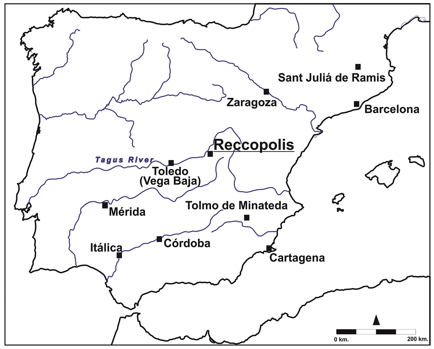
Figure 1. Main sites mentioned in the text (figure by L. Olmo Enciso & M. Castro Priego).

Figure 2. Reccopolis: geomagnetic prospection in 2015 (photograph by J. Henning & E. Fikrit Eyub).
The significance of royal Reccopolis
After war with the Franks in AD 507 had destroyed the kingdom's fifth-century configuration in southern Gaul and Iberia, King Leovigild (568–586) secured a Visigoth-led polity centred on Iberia. Victorious campaigns against the Byzantines, Suevic, indigenous aristocratic and peasant opponents, and also against independent cities allowed Leovigild to re-establish a centralising monarchy modelled on Byzantium: by developing a royal capital at Toledo, assuming monarchical insignia, striking gold coins in his own name and establishing a tax system (McCormick Reference McCormick1990: 298–323; Olmo Enciso Reference Olmo Enciso, García, Izquierdo, Enciso and Peris2010: 101–102, 106).
The main historians of the time—John of Biclar and Isidore of Seville—report that Leovigild also founded a new city in Celtiberia, in the southern Meseta of modern Spain. In an apparently defiant reference to the imperial Byzantine capital, Constantinople, Leovigild named the new city ‘Reccopolis’ after his son and future successor, Reccared. John emphasises that Leovigild adorned the new town with marvellous construction in its walls and the surrounding area, and, presumably to encourage immigration, granted special privileges for the population (Claude Reference Claude1965: 187–93; cf. Rodríguez Alonso Reference Rodríguez Alonso1975: 258; Cardelle de Hartmann Reference Cardelle de Hartmann2001: 185–90). Local oral tradition, medieval Arab chronicles, Christian documents and decades of archaeological research have now definitively identified the location of the city, 1.5km south of the early medieval Islamic town of Zorita de los Canes (Olmo Enciso et al. Reference Olmo Enciso, Priego, Torre-Verdejo, Sanz Paratcha and Enciso2008; Olmo Enciso Reference Olmo Enciso, Baquedano, García Moreno and Vigil-Escalera2012, Reference Olmo Enciso, Gelichi and Hodges2015; Castro Priego Reference Castro Priego2016). The partially excavated ashlar city walls and towers, one of which survives to 5.8m in height, measure up well to the description of an exceptional royal foundation (Gómez de la Torre-Verdejo Reference Gómez de la Torre-Verdejo and Enciso2008).
Archaeological research at Reccopolis began in 1944 and has continued to the present day. Investigations began with the ‘palace’, a conspicuously sited monumental complex, which yielded the foundations of large multi-storey buildings, one of which measured 140 × 12–18m and would have afforded breath-taking views of the surrounding landscape (Figure 3.7). Excavations also revealed a vast open courtyard (measuring 136 × 40m), sculptural decoration, an impressive gatehouse facing out from the palace towards the settlement, and a richly appointed church (Olmo Enciso Reference Olmo Enciso2006: 60–71). The most recent work at Reccopolis, undertaken by Lauro Olmo Enciso and the University of Alcalá (1982–1987 and 1992 to present; Olmo Enciso Reference Olmo Enciso and Enciso2008b), has uncovered the palace gate and contiguous houses and shops (Figures 3 & 4.6–13), as well as around 300m of the 1887m-long city wall. Field-walking survey of the surrounding territory has identified small rural, Visigothic-era settlements, as well as traces of an aqueduct, probably for the supply of water to Reccopolis (Olmo Enciso Reference Olmo Enciso, Gelichi and Hodges2015: 32–34). As yet, neither contemporaneous cemeteries nor evidence for significant pre-AD 578 occupation have been identified at the site.

Figure 3. Reccopolis: geomagnetic prospection interpreted (figure by K. Rassmann & H. Höhler-Brackmann).

Figure 4. Reccopolis: geomagnetic prospection interpreted and detail of excavated areas (figure by K. Rassmann & H. Höhler-Brackmann).
As a major centre, Reccopolis had a relatively short life span of around two centuries, 133 years of which were under Visigothic rule—from its documented foundation in AD 578 to the collapse of the Visigothic kingdom in the Arab-Berber conquest of 711. Its mint issued coins under Leovigild, Reccared (586–601), Sisebut (612–621), Swinthila (621–631) and Witiza (c. 700–710) (Castro Priego Reference Castro Priego2016: 33). Archaeological research and historical records agree that Reccopolis continued to be a significant central place in the early Islamic period. Approximately 1.5km upstream from Reccopolis on the Tagus River, a site known as Suritah (modern Zorita) emerged no later than AD 812, and became head of an administrative district—possibly as part of a broader restructuring of the landscape's productive capacities, often around newly established centres (Olmo Enciso Reference Olmo Enciso, Baquedano, García Moreno and Vigil-Escalera2012: 42–46, 51–55, 57–60). Arabic sources testify that spolia from Reccopolis were used to construct the new citadel and fortified town—a claim confirmed archaeologically and by standing remains; one robber trench in the Visigothic palace area, for example, yielded Islamic red-painted common pottery dated to the first half of the ninth century (Olmo Enciso Reference Olmo Enciso, Baquedano, García Moreno and Vigil-Escalera2012: 54–55). The short span of core activity at Reccopolis means that its archaeological horizons are crucial for establishing the chronology of Visigothic and early Islamic archaeology in central Iberia.
Doubt concerning the urban extent of the palatial complex, the absence of clear evidence for other structures within the walled area, and Reccopolis's critical standing in the emerging archaeology of post-Roman Iberia prompted the authors to devise a new archaeological approach. Our aim was to determine the existence and extent of the built-up area(s) within the 21.5ha area delimited by the city walls but not previously subject to excavation. Within the constraints of time, funds and site accessibility, geomagnetic prospection was selected as the most suitable approach for determining whether the historical record of the foundation of the city—labelled civitas in the contemporaneous written sources—in fact corresponds to an actual urban settlement. Further, if additional occupation were identified where scattered surface finds had included roof tiles, ceramics and glass, would its spatial patterns, distribution and density indicate variability in occupation and the organised development of structures across the site? Were there any further (unexcavated) structures associated with the palace complex, and what of the area outside the only gate that has been published archaeologically?
The geomagnetic survey
Open areas of the site were geomagnetically surveyed in 2015 to determine whether the dense urban fabric that has been excavated immediately next to the palace was matched in all or part of the unexcavated 92.4 per cent of the walled area. The results show that much, if not all, of the prospected area was built up, often at considerable density. This argues strongly in support of the interpretation that, at some point during its 200-year life span, Reccopolis—within its walls—did indeed resemble a contemporaneous or earlier Roman town. The majority of the structures are rectilinear and oriented on a limited number of axes north-north-west to south by east (i.e. a line running from 338–170°).
The geophysical plan shows what appear to be five or six separate clusters of buildings within the walls; in fact, the ‘empty’ spaces in between these clusters were not accessible for survey due to the terrain and vegetation. Linear features that resemble streets connect the multiple zones that were surveyed, and probably extend a grid pattern suggested by the three archaeologically attested streets, two of which have been published (Olmo Enciso Reference Olmo Enciso, Gelichi and Hodges2015: 33–34). The geomagnetic survey reveals that the previously excavated 75m of an east–west-running street (Figure 3.1) continues for approximately 125m both westwards and eastwards (Figure 3.2) beyond the excavated zone. Given that it intersects with the southern end of the north–south street (Figure 4.1) that leads to the palace, this long thoroughfare may have been the main east–west axis of the town. Another geomagnetically detected street south of the main east–west axis (Figure 3.3) appears to run, broadly, parallel to this north–south palace street.
Some variation in the orientation of the streets and buildings certainly reflects the geological and topographical relief of the site. The city was built atop a steep mesa dominated by a broad, horseshoe-shaped, relatively flat-topped ridge that lies open towards the west, and that rises gently from 700m asl at its northern tip to 702m asl at its southern tip. A smaller terrace-like plain of approximately 1ha marks the north-westernmost part of the mesa. The rectangular western end of the ridge, on which the palace complex sits, suggests that it has been artificially terraced, at least in part; the presence of retaining walls could explain some of the linear features detected by the geomagnetic survey (e.g. Figure 3.5). One such retaining wall, 50m long, has been documented archaeologically on the eastern side of the north–south street leading to the palace (Figure 4.2; Olmo Enciso et al. Reference Olmo Enciso, Priego, Torre-Verdejo, Sanz Paratcha and Enciso2008: 67). The interplay of relief, drainage and water conduits may also have introduced variants in the grid plan. At least one water channel has been uncovered on the eastern side of the street leading to the palace gate (Figure 4.3); it probably connected to an excavated cistern (Figure 4.5) and seems to date from the first phase of the city (Olmo Enciso Reference Olmo Enciso and Enciso2008a: 55). The rest of Reccopolis's hydraulic infrastructure remains to be discovered, including its probable connection with the aqueduct outside the walls, although some of the long linear features detected in 2015 probably relate to this.
Finally, the orientation of several buildings appears to be influenced by ideological considerations. The palatine church (Figures 3.4 & 4.4), for example, has its apse towards the east. There must have been at least one other church within the walls for the general population's spiritual needs and elite social display. One large (approximately 20 × 40m) newly discovered feature is certainly oriented quite differently from the palatine church (Figure 3.6); indeed, it is the only building with this particular orientation so far discovered. What appears to be its broad side faces towards the south-east (Figure 5a–b). In light of the site's early Islamic phase, this feature requires further exploration. The earliest mosques in Iberia date to the eighth century, although these are known predominantly from written sources (Calvo Capilla Reference Calvo Capilla2007). The two eighth-century mosques in Iberia at present identified archaeologically correspond to the first phases of the Umayyad Great Mosque of Cordoba (AD 785–788; Ewert Reference Ewert and López Guzmán1995) and the Great Mosque of Zaragoza (Hernández Vera Reference Hernández Vera2004: 75). The tendency in Islamic Iberia was to orient mosques between south-east and south (Rius Reference Rius2000: 105).

Figure 5. Reccopolis: possible early Islamic mosque: a) geomagnetic; b) interpretation; c) Jarash, Umayyad mosque; d) Khirbat al-Minya, Umayyad mosque (figure by J. Henning, E. Fikrit Eyub, K. Rassmann & H. Höhler-Brackmann).
Insofar as can be discerned from the geomagnetic data, the plan of the large structure at Reccopolis recalls those of Umayyad mosques in the Levant, particularly that at Jerash, Jordan (Figure 5c), where a series of structures (shops and an access platform) line the side of the building perpendicular to the south-facing, triple-aisled prayer hall, and back onto a long hall or portico that is oriented perpendicular to the prayer hall (Walmsley & Damgaard Reference Walmsley and Damgaard2005). Although the geomagnetic survey is inconclusive, the Reccopolis structure might also indicate a three-aisled hall (Figure 5b); such features are characteristic of Levantine Umayyad mosques—notably the Great Mosque of Damascus, the newly discovered mosque in Tiberias, and that of Khirbat al-Minya (Figure 5d), 14km north of Tiberias (Cytryn-Silverman Reference Cytryn-Silverman2009: 49–51, Reference Cytryn-Silverman, Matthews and Curtis2012).
The geomagnetic data from Reccopolis invite comparison of the excavated structures with those detected by prospection in neighbouring unexcavated zones. The most important and unexpected of these is situated directly to the east of the excavated palace (Figures 3 & 4.7). Three large structures and part of a fourth are clearly visible, as are two smaller structures (Figures 3 & 4.8). The two largest are approximately 20m wide and at least as long. By their size and plan they recall buildings such as the episcopal palace of Visigothic Barcelona (Figure 6c), the elite residence at Sant Julià de Ramis (Figure 6d; Burch et al. Reference Burch, Garcia, Nolla, Palahí, Sagrera, Sureda, Vivó and Miquel2006; Beltrán de Heredia Reference Beltrán de Heredia2009) and early Islamic aristocratic buildings at Merida (Figure 6e; Mateos & Alba Reference Mateos, Alba, Zoreda and Cruz2000). The resemblance to the residences with audience halls excavated at Justinianic Caričin Grad, in both plan (Figure 7a) and organisation (Figure 7b), is particularly striking (Caillet et al. Reference Caillet, Vasić, Popović, Duval, Bjelajac, Prica, Lazić, Duval and Popović2010; Metzger et al. Reference Metzger, Duval, Baratte, Caillet, Prica, Duval and Popović2010). The location of the structures at Reccopolis suggests that these newly discovered buildings may also have formed part of the palace compound.

Figure 6. Reccopolis: new buildings east of the excavated palace: a) geomagnetic; b) interpretation; c) episcopal palace, Barcelona; d) elite residence, Sant Julià de Ramis; e) early Islamic elite buildings, Merida (figure by J. Henning, E. Fikrit Eyub, L. Olmo Enciso & M. Castro Priego).

Figure 7. Caričin Grad: a) residences with audience halls; b) complex IV (figure by K. Rassmann & H. Höhler-Brackmann).
An excavated complex of shops and workshops, each measuring 12 × 9m, including a glass workshop (Figure 4.9), lines the west side of the street (Figure 4.1) that leads to the palace gate (Figure 4.6). On the eastern side of the street, excavation has uncovered a similar set of three shops (Figure 4.10), including a goldsmith's workshop. Adjoining the western edge of the complex that stands on the street's western side is the ground floor of a large residence from the earliest phase of building (Figure 4.11) measuring 31 × 14.2m, and approximately 420m2. Its location next to the palace, combined with the presence of coins (including a gold tremissis of Leovigild, issued AD 580–586: Castro-Priego Reference Castro Priego2016: 47), a varied assemblage of pottery and glass, and imported fineware and amphorae dating to the late sixth and seventh centuries (Bonifay & Bernal-Casasola Reference Bonifay and Bernal-Casasola2008: 103–107), indicates the high social status of the building's occupants. Immediately adjoining this large residential building is a second house (Figure 4.12) of similar design and dimensions (approximately 30 × 14.1m), of which only approximately 300m2 has been excavated. Both houses feature central corridors that open onto the southern end of the east–west street. Adjoining the large, fully excavated house to the north was a small courtyard (14.75 × 12m), to which one shop and a further house also had access (Figure 4.13). The geomagnetic prospection suggests that both large houses formed part of a larger rectangular block of buildings. Furthermore, their orientation appears to align with the newly detected structures east of the main palace complex (Figure 4.8). Stratigraphic excavation in the 2000s enabled detailed reconstruction of the changing use and design of the larger building complex under both Visigothic and early Islamic rule (Olmo Enciso Reference Olmo Enciso, Baquedano, García Moreno and Vigil-Escalera2012: 42–43).
Other rectangular features around the city are reminiscent of Mediterranean courtyard houses. In Iberia, archaeologically documented examples of this house type occur in sixth- and seventh-century urban contexts in Mérida—in both late Roman mansions (domus) remodelled into smaller houses structured around patios, and in new houses in Vega Baja (Toledo), and in Byzantine Cartagena (Figure 8b–d; Alba Calzado Reference Alba Calzado, Brogiolo and Chavarría2007; Vizcaíno Sánchez Reference Vizcaíno Sánchez2007; Olmo Enciso Reference Olmo Enciso, García, Izquierdo, Enciso and Peris2010: 95, 98, 109). At Reccopolis, some of these house features seem to comprise multiple rooms (Figure 4.11; cf. Figure 8a). Geophysical prospection, of course, leaves many questions unanswered. Some features, for example, may be interpreted as single-room houses or workshops (Figure 3.10), although these do not dominate the picture; some may be interpreted as medium-sized, multiple-room houses, while others could be interpreted as considerably more substantial complexes (Figure 3.11).

Figure 8. Visigothic houses: a) Reccopolis (Figure 4.11); b) Merida; c) Toledo, Vega Baja; d) Cartagena (figure by L. Olmo Enciso & M. Castro Priego).
Multiple parallel linear features may, in some cases, represent traces of additional artificial terracing or retaining walls. Others resemble streets or perhaps alleys between complexes, or water and drainage installations, such as the excavated water channel cited above. Aside from streets and small courtyards, uninhabited areas so far identified inside the walls include only the open courtyard of the palace complex and its church. The large buildings detected at the eastern end of the settlement's northern ridge, which we suggest form part of the palace complex, may also have had open spaces around them.
Finally, the geomagnetic survey has, for the first time, securely identified an extramural suburb, which is located immediately outside the sole excavated (western) gate of Reccopolis—that is, in the direction leading towards Toledo. In 2015, we detected two clear structures in the 2.17ha prospected outside of this gate. One (Figure 3.12) could be interpreted as a single-room house, while another (Figure 3.13) appears to be more substantial. Both share the same orientation. The geomagnetic survey suggests that, if these structures date to the Visigothic phase, the suburb was less densely built up than the intramural areas.
The possible population size of Reccopolis at its peak can be estimated in different ways. Much depends on whether the sloping areas of the relief were as built up as the level areas; although vegetation and other obstacles prevented the complete prospection of most of the intramural slopes, those that could be investigated show dense building (Figure 3). If it is legitimate to compare work on Roman towns to the immediate post-Roman period, the figure of 100 inhabitants per hectare suggested for towns in Roman Spain and Britain (Wilson Reference Wilson, Bowman and Wilson2011: 181) would yield an approximate population of 2100 for the intramural area at Reccopolis. This figure falls within the middle of the range developed for second-century AD Roman vici in the Germanic provinces (Wendt & Zimmermann Reference Wendt and Zimmermann2008: 205–19). To this number should be added whatever population lived in the area immediately outside the walls. One might speculate that the extramural settlement amounted to only a few hundred people, giving an overall hypothetical population of approximately 2500; even this may be on the high side, and it falls 50 per cent short of the threshold of 5000 that Wilson takes for the recognition of non-agrarian, urban settlements at the height of the Roman Empire (Wilson 2011: 179–82).
Another, less speculative, way to evaluate the population size at Reccopolis in the context of Roman urbanism in Iberia is to compare the walled area of settlements (cf. de Ligt Reference de Ligt, Vermeulen, Burgers, Keay and Corsi2012: 184). Many of the 107 sites whose fortifications allow this calculation (Carreras Monfort Reference Carreras Monfort1995) date from the straitened circumstances of the third century AD (Marzano Reference Marzano, Bowman and Wilson2011: 207), and so perhaps provide a more appropriate point of comparison for a sixth-century town. Among them, at 21.5ha, Reccopolis would have ranked in the upper third (thirty-second from the top), being a little smaller than Saguntum (Sagunto), about the same size as Emporion (Empúries, 21ha), Bilbilis (Calatayud) and Legio (León), and larger than Segobriga (12.5ha), Barcelona, Numancia and Seville (all 12ha; Carreras Monfort Reference Carreras Monfort1995). On this basis, one can understand how contemporaries considered Reccopolis to be a city or ‘civitas’.
A royal town founded in a time of change
From China to Britain, sixth- and seventh-century AD kingdoms and empires experienced crisis, collapse and, sometimes, coalescence, amid the challenges of rapid environmental and demographic changes during the Late Antique Little Ice Age, initiated across Eurasia by the volcanic winter of 536, and the two-century-long Justinianic bubonic plague pandemic from 541 (McCormick Reference McCormick2015, Reference McCormick2016; Büntgen et al. Reference Büntgen2016; Feldman et al. Reference Feldman, Harbeck, Keller, Spyrou, Rott, Trautmann, Scholz, Päffgen, Peters, McCormick, Bos, Herbig and Krause2016). The rise and fall of urban life is an intensely debated part of this picture, amidst broad social, political and economic reorganisations, whose causal connections with newly documented environmental and demographic changes remain unknown. The Iberian kingdom of the Visigoths was one of the new polities that emerged during this challenging period.
Our results contribute new evidence to the debate concerning towns and their transformations in this transitional era from antiquity to the Middle Ages (Henning Reference Henning2007; García et al. Reference García, Izquierdo, Enciso and Peris2010; Gelichi Reference Gelichi, García, Izquierdo, Enciso and Peris2010; Lavan Reference Lavan and Morrisson2012). Archaeology has illuminated their decline, and even disappearance, during the second half of the sixth or the seventh century (Liebeschuetz Reference Liebeschuetz2001; Christie & Augenti Reference Christie and Augenti2012; Haldon Reference Haldon, Daim and Drauschke2016). More complex patterns of city survival or recovery have been detected in the Balkans and the Levant during the early and later sixth century, respectively (Kirilov Reference Kirilov2006; Avni Reference Avni2014). The Roman emperor Justinian (527–565), for example, founded a short-lived new city, Iustiniana Prima-Caričin Grad, c. 535 (Ivanišević Reference Ivanišević, Daim and Drauschke2016).
In Iberia, however, a generalising approach to urban change is yielding to recognition of the variation in developments affecting central sites and their surroundings (Olmo Enciso Reference Olmo Enciso, Gelichi and Hodges2015: 29, 34–37, 41). John of Biclar claims that in 581, Leovigild founded another new city—Victoriacum—in northern Iberia (Cardelle de Hartmann Reference Cardelle de Hartmann2001: 72). Similarly, King Swinthila (621–31) supposedly established a new city named Ologicus (Rodríguez Alonso Reference Rodríguez Alonso1975: 276–78). Although archaeological investigation has yet to confirm either of these enterprises, material evidence of urban renewal has recently emerged in a later sixth-century suburb (modern Vega Baja) of the main royal capital, Toledo (Olmo Enciso Reference Gelichi, García, Izquierdo, Enciso and Peris2010). Another apparently late sixth- or early seventh-century foundation has been discovered in south-eastern Iberia, on the marches of the Byzantine province of Spain, at the bishopric of Eio-El Tolmo de Minateda in Hellín. Here, recent excavations have identified an episcopal complex of cathedral, baptistry and ‘palace’, along with houses and parts of the town wall (Gutiérrez Lloret & Sarabia Bautista Reference Gutiérrez Lloret and Bautista2013). The apparent exceptionalism of the Iberian written and archaeological evidence concerning urban renewal sponsored by royalty lends particular significance to the new evidence for the nature and extent of the royal foundation of Reccopolis.
The written sources document a resurgent Visigothic monarchy whose ambitions included, extraordinarily in the late sixth-century context, the founding of new cities. Doubts about the urban character of Reccopolis can now be set aside. Reccopolis represents a new town created ex novo in the late sixth century, and is thus far the only archaeologically documented example of a new city founded by a northern group whose ethnogenesis replaced the Roman order. Magnetic survey has revealed that Reccopolis was indeed extensively built up and occupied within its impressive walls. The previously excavated walls, palace structures and workshop/shop complexes on the street leading to the palace—as well as the aqueduct approximately 2km away—already suggested that the newly secured and confident Visigothic monarchy disposed of considerable resources. On the basis of our geomagnetic survey, Reccopolis now emerges unambiguously as an extraordinary statement of the Visigothic monarchy's power and ideological ambition in an age characterised elsewhere by crisis. Our survey confirms the scale of expenditure that attended the development of Reccopolis, increasing the urgency for further investigation of the site and identification of the resources that supported this foundation and growth.
Nonetheless, many questions remain to be answered. To what extent was the glass- and metalwork production, previously identified by excavation, geared to the royal household and its followers? What was life like in the buildings newly identified across and outside the walled space? To what extent can these new structures allow us to discern and understand features of urban life, such as the transport infrastructure, exchange and markets and relations with the countryside and rural production? We expect future investigations to uncover more evidence about the origin, character, lifestyles and economic activities of the population of Reccopolis, the physical structures of which are now broadly revealed.
Acknowledgements
We are grateful to the University of Alcalá de Henares, Goethe University of Frankfurt, Harvard University (Initiative for the Science of the Human Past), the Consejería de Educación y Cultura de La Junta de Comunidades de Castilla-La Mancha and the Ayuntamiento de Zorita de los Canes (Guadalajara province) for their support, and to Hajo Höhler-Brackmann, Römisch-Germanische Kommission of Frankfurt, for help with the figures. Beyond those named in the text, the team included Joaquin Checa Herraiz and Manuel Castro Priego (Alcalá de Henares); Peter Henning and Marc Lorenz (Goethe University); Jakub Kabala, Jake Ransohoff and Richard Rush (Harvard).
Supplementary material
To view supplementary material for this article, please visit https://doi.org/10.15184/aqy.2019.66


