


1. Introduction
The origin of the Antarctic Peninsula is currently described by contrasting models, where deformation, metamorphism and plutonism of the peninsula are suggested to be the product (1) of an in situ development of a complete arc/trench system (Smellie, Reference Smellie1981) or (2) of contraction and crustal thickening related to growth by accretion of exotic terranes (Vaughan & Storey, Reference Vaughan and Storey2000; Vaughan, Pankhurst & Fanning, Reference Vaughan, Kelley and Storey2002).
In the arc–trench model, plutonism and metamorphism are argued to have taken place in a convergent setting along the palaeo-Pacific margin from pre-Jurassic times to Tertiary times (e.g. Smellie, Reference Smellie1981; Smellie & Clarkson, Reference Smellie and Clarkson1975; Suarez, Reference Suarez1976, Pankhurst, Reference Pankhurst1990; Millar, Pankhurst & Fanning, Reference Millar, Pankhurst and Fanning2002). In the terrane model, Vaughan & Storey (Reference Vaughan and Storey2000) and Vaughan, Pankhurst & Fanning (Reference Vaughan, Kelley and Storey2002) suggested pre-Late Cretaceous terrane accretion based on structural data that indicate a major dextral strike-dip slip shear zone in eastern Palmer Land (Palmer Land event), the Eastern Palmer Land Shear Zone (EPLSZ) (for geographical position of Palmer Land, see inset in Fig. 1). Geochemical data suggest tectonic activity peaked with the onset of subduction during the Early Cretaceous in central western Palmer Land (Leat, Scarrow & Millar, Reference Leat, Scarrow and Millar1995), inducing shearing along the Eastern Palmer Land Shear Zone, which ceased during the mid-Cretaceous (Vaughan, Wareham & Millar, Reference Vaughan, Wareham and Millar1997).

Figure 1. Positions of localities mentioned in text. Light grey areas around the Antarctic Peninsula and Alexander Island represent ice shelves. Abbreviations: Isld. – Island; Mt. – Mount; Nts. – Nunataks; Pen. – Peninsula
Against this background, we present a three-fold approach for characterizing the distribution and grades of metamorphic rocks in the Antarctic Peninsula region. We first present qualitative maps that show the distribution of main metamorphic rock types at peninsula region scale. Secondly, we present a set of quantitative pressure–temperature (P–T) data from selected areas on the Antarctic Peninsula. The new P–T data are subsequently embedded in a literature review of the current knowledge on regional Antarctic Peninsula metamorphism, including islands adjacent to the west coast of the peninsula. In detail, we present (1) metamorphic maps outlining the occurrence of orthogneisses, metabasites (metabasalts and amphibolites) and metasediments at peninsula region scale. We calculate (2) quantitative peak pressure–temperature conditions recorded by metasediments, and by metamorphic rocks of the magmatic belt from various regions of the peninsula. P–T conditions were calculated using TWEEQ 2.02 (Berman, Reference Berman1991), and the plagioclase–hornblende method (Holland & Blundy, Reference Holland and Blundy1994) where appropriate. We then produced a peninsula region-scale map of main metamorphic facies integrating the new P–T data with the existing knowledge on metamorphism in the Antarctic Peninsula region. This has allowed us to delineate a general metamorphic pattern of the Antarctic Peninsula region between 62° S and 73° S.
In the following, localities mentioned in the text are shown on Figure 1; principal metamorphic facies are expressed using the notation of Holdaway (Reference Holdaway1971).
2. Geological setting
The Antarctic Peninsula is one of five crustal blocks in West Gondwana (Storey & Alabaster, Reference Storey and Alabaster1991) that extended from South America through the Antarctic Peninsula to Marie Byrd Land and New Zealand (Fig. 2). Today, the peninsula and associated islands extend approximately 2000 km from the South Shetland Islands in the north to Haag Nunataks in the south (Fig. 1). The Antarctic Peninsula consists of Palaeozoic crystalline rocks (Storey & Garrett, Reference Storey and Garrett1985; Millar, Pankhurst & Fanning, Reference Millar, Pankhurst and Fanning2002), Gondwana metasediments, meta-igneous rocks, greywackes (Smellie, Reference Smellie1981) and subduction-related volcanic rocks of Late Jurassic to Tertiary age (Thomson & Pankhurst, Reference Thomson, Pankhurst, Oliver, James and Jago1983). Magmatic pulses emplaced gabbroic and granitic material from Cretaceous to Eocene times (e.g. Leat, Scarrow & Millar, Reference Leat, Scarrow and Millar1995; Vaughan, Wareham & Millar, Reference Vaughan, Wareham and Millar1997). In the more recent model of Vaughan & Storey (Reference Vaughan and Storey2000), the geology of the Antarctic Peninsula was explained by the presence of two suspect terranes in contact with para-autochthonous rocks of the continental Gondwana margin along the Eastern Palmer Land Shear Zone (Vaughan & Storey, Reference Vaughan and Storey2000). Tectonic activity peaked with the onset of subduction during the Early Cretaceous (142 Ma) in central western Palmer Land (Leat, Scarrow & Millar, Reference Leat, Scarrow and Millar1995), inducing shearing along the Eastern Palmer Land Shear Zone, which ceased during mid-Cretaceous times (Vaughan, Wareham & Millar, Reference Vaughan, Wareham and Millar1997).

Figure 2. Early Cretaceous plate reconstruction of the tectonic setting of the Antarctic Peninsula in relation to the main crustal blocks of Gondwana and subduction along the palaeo-Pacific Gondwana margin (modified after Storey, Vaughan & Millar, Reference Storey, Vaughan, Millar, Storey, Livermore and King1996; Vaughan, Wareham & Millar, Reference Vaughan, Wareham and Millar1997).
Vaughan & Storey (Reference Vaughan and Storey2000) separated the southern Antarctic Peninsula into a suspect Central Domain, representing the magmatic arc and largely equivalent to the Antarctic Peninsula batholith of Leat, Scarrow & Millar (Reference Leat, Scarrow and Millar1995), and an Eastern Domain, which probably represents the continental Gondwana margin (Fig. 3). To the west of the Central Domain, a Western Domain consists of the accretionary complex exposed in Alexander Island (e.g. Storey & Garrett, Reference Storey and Garrett1985). It is separated from the Central Domain by George VI Sound, a Tertiary transtensional feature (Storey & Nell, Reference Storey and Nell1988; Maslanyj, Reference Maslanyj1988) obscuring the exact relationship between Alexander Island and Palmer Land. The geographical position of the Antarctic Peninsula with respect to Antarctica is shown in the inset of Figure 3.

Figure 3. Domain boundaries delineating three terranes in the Antarctic Peninsula. The Eastern Palmer Land Shear Zone (EPLSZ) separates the magmatic arc from Gondwanian sequences (modified after Vaughan & Storey, Reference Vaughan and Storey2000).
3. Methods and sample description
3.a. Mapping
Outcrops containing metamorphic rocks in several previously unexplored areas on the Antarctic Peninsula were mapped during the austral summer months 2002/03 and 2003/04. The field areas, along the east side of the spine of the peninsula in central Graham Land and in northeast Palmer Land, are shown on the sample maps in Figure 4a–c. Strongly deformed high-grade orthogneisses and amphibolites were sampled in central east Graham Land, and high-grade orthogneisses, metasediments and amphibolites were sampled in NE Palmer Land. (Despite careful textural and petrological analysis, however, it was not always possible to distinguish between paragneisses and orthogneisses.) During the field seasons, 115 oriented and unoriented metamorphic samples were collected. All of them were optically analysed.

Figures 4. (a–c) Maps of all studied samples of the Antarctic Peninsula region. Areas of lead author's fieldwork are also shown.
In addition to this, the Antarctic Rock Collection and Data Base of the British Antarctic Survey (BAS) in Cambridge were used to identify many other areas on the Antarctic Peninsula and on islands adjacent to its west coast, from which metamorphic rocks were described in the past. We extracted 570 metamorphic rock samples (orthogneisses, metabasites and metasediments) from the BAS Antarctic Rock Collection. Samples were quality controlled by checking hand specimens, thin-sections, field reports and publications. For map-making, the selected specimens were located on point plots (Fig. 4a–c).
3.b. Sample description
Metasedimentary rocks formed large tectonic slivers in northeast Palmer Land, and in Scripps Heights in magmatic rocks, which were in some parts highly deformed. The original sediments were probably marine/terrestrial and/or eroded igneous material and deposited on the Gondwana margin (Fig. 5a, b). The sampled metasediments comprised high-grade metamorphic conglomerates with a fine matrix (R 8178.1, Fig. 5a) containing quartz + muscovite + plagioclase ± garnet ± calcite; the fine-grained metapelites (no optical analyses possible) were associated with a meta-conglomerate containing felsic and mafic pebbles (R 8179.1, Fig. 5b); and hornfelsed shale-like metasediments (R 8182.2, Fig. 5c). Metasediments selected from the BAS Antarctic Rock Collection were highly deformed (garnet-bearing) metapelites. They were mainly composed of quartz + muscovite + plagioclase ± garnet ± andalusite ± sillimanite ± cordierite ± biotite ± chlorite. Garnets in all studied metasediments had a high almandine component.

Figures 5. Overview of main rock types. (a) R 8178.1; (b) R 8179.1; (c) R 8182.2; (d) R 8143 (outcrop); (e) R 8179.3; (f) R 8139 (outcrop); (g) R 8181.2; (h) R 8178.4. Centimetre ruler used for scale.
Metamorphosed magmatic rocks of granitic composition are widespread in the Antarctic Peninsula. Orthogneisses sampled during the field seasons and from the BAS Antarctic Rock Collection mainly consisted of feldspar + plagioclase + biotite + quartz ± garnet ± hornblende ± chlorite ± apatite ± tourmaline ± muscovite. Garnets in the orthogneisses were often of almandine–grossular composition. The orthogneisses showed remarkable differences in metamorphism and deformation from nearly unchanged coarse-grained igneous, to metamorphosed, strongly foliated and ultramylonitic (Fig. 5d–f, R 8143 (outcrop); R 8179.3; R 8139 (outcrop)) textures along shear zones. Metamorphosed mafic rocks were also widely distributed. They comprised amphibolites and altered basalts (metabasalts) of different degree in deformation (Fig. 5g, h) and metamorphism. Amphibolites (R 8181.2, Fig. 5g) were composed of green hornblende + biotite + plagioclase ± garnet ± epidote ± chlorite. Metabasalts (R 8178.4, Fig. 5h) comprised feldspar + chlorite + biotite + hornblende + plagioclase. Pyroxenes were not observed in the studied samples.
From the 685 mapped metamorphic rock samples, we analysed the geothermobarometric conditions (pressures and temperatures) of 30 samples. These rock samples were all exposed in areas that were tectonically active in the past and had produced either isolated subprovinces or major shear or fault zones on the Antarctic Peninsula. The samples comprised 17 orthogneisses, 3 metabasites and 10 metasediments. They were a representative cross-section of all samples reported for the Antarctic Peninsula on the maps in Figure 4a–c. A detailed description of the samples used for geothermobarometric analyses is given in Table 1, where we provide sample reference, regional name, geographical coordinates, rock type and the main crystal constituent of the rocks. The geographical distribution of the analysed samples is visualized on Figure 6a and b.
Table 1. Samples used for geothermobarometric analyses

Given are sample number, location, geographical coordinates, rock type, main crystal phases constituting the rock samples, mineral assemblage used for P–T calculations, calculated pressures and temperatures, and the calculation method. Maximum statistical error for each P–T calculation was ±0.8 kbar, ±60°C (details see text). Pressure and temperature which were calculated based on more than 3 equilibrium curves are denoted by ‘*’. For each of these samples a deviation > 1 bar and 1 °C was calculated by TWEEQ 2.02 (Berman, Reference Berman1991). All other calculation revealed deviations smaller than 1bar and 1°C. (Specific P–T deviations are as follows: E4010.1: 280 bar, 17°C; R2137.2: 50 bar, 10°C; R 4201.5: 121 bar, 12 °C; R2437.4: 1400 bar, 116°C; R2436.3: 4 bar, 1°C). (Abbreviations: Mt – Mount, Ntk – Nunatak; and – andalusite, apat – apatite, bi – biotite, cc – calcite, chl – chlorite, cord – cordierite, ep – epidote, gt – garnet, hbl – hornblende, kfsp – feldspar, ms – muscovite, monaz – monazite, plag – plagioclase, sill – sillimanite, qz – quartz).

Figure 6. (a) Geographical positions of the P–T quantified samples and major shear and fault zones. Black dots: sample sites. (b) Geographical distribution of P–T conditions and geographical positions of major shear and fault zones. Black dots – sample sites with meta-igneous rocks; black stars – sample sites with metasediments. Symbols in (a) and (b): finely dashed lines – identified shear zones and faults; broadly dashed line – projected shear zones. Shear and fault zones as follows: Tertiary Adelaide fault (Johnson, Reference Johnson1999), some early Cretaceous shear zones in northwest Palmer Land (west of Campbell Ridges & Traverse Mountains, Vaughan & Millar, Reference Vaughan and Millar1996) the Jurassic/Early Cretaceous Auriga Nunatak Shear Zone area (ANSZ) (Vaughan, Millar & Thistlewood, Reference Vaughan, Millar and Thistlewood1999), and the pre-late Cretaceous Eastern Palmer Land Shear Zone (EPLSZ) (Vaughan & Storey, Reference Vaughan and Storey2000; Vaughan, Pankhurst & Fanning, Reference Vaughan, Pankhurst and Fanning2002).
3.c. Geothermobarometry
Geothermobarometric analyses were performed on specimens from the Target Hill subprovince (Vaughan & Storey, Reference Vaughan and Storey2000) in central east Graham Land, around the Tertiary Adelaide fault zone (Johnson, Reference Johnson1999) located in the transitional zone between Graham Land and Palmer Land, around some early Cretaceous shear zones in northwest Palmer Land (west of Campbell Ridges, Traverse Mountains: Vaughan & Millar, Reference Vaughan and Millar1996), the Jurassic/Early Cretaceous Auriga Nunatak Shear Zone area (ANSZ) in central Palmer Land (Vaughan, Millar & Thistlewood, Reference Vaughan, Millar and Thistlewood1999), and along the pre-late Cretaceous Eastern Palmer Land Shear Zone (EPLSZ) and its possible northern extension (eastern Palmer Land) (Vaughan & Storey, Reference Vaughan and Storey2000; Vaughan, Pankhurst & Fanning, Reference Vaughan, Kelley and Storey2002) (Fig. 6a, b).
Geothermobarometry was carried out by application of calibrated mineral equilibria of solid solutions. To do so, we first analysed the chemical mineral compositions of 50 rock samples, comprising orthogneisses, metabasites and metasediments, by electron microprobe using a Cameca SX-100 facility at the Earth Sciences Department of the University of Cambridge, UK. Run conditions were 15 keV accelerating voltage, ~20 nA beam current, and 5.5 μm2 spot size. Depending on the individual rock composition, we analysed garnet, feldspar, plagioclase, mica, biotite, chlorite, amphiboles, epidote, alumino-silicates, cordierite and some accessory minerals (e.g. apatite, tourmaline, titanite, rutile). The rock type and the mineralogical composition of each individual rock sample are given in Table 1. Representative analyses of the chemical compositions of the investigated key minerals of selected samples are given in Tables 2–5.
Table 2. Representative chemical compositions of plagioclase

Table 3. Representative chemical compositions of cordierite and hornblende

Table 4. Representative chemical compositions of garnet

Table 5. Representative chemical compositions of biotite of selected samples

Fundamental to our thermobarometric study was the attainment and freezing of equilibrium compositions at peak metamorphic conditions. All rocks here investigated departed to a certain degree from such ideal behaviour, and non-equilibrium assemblages occurred widely in the study area, as shown by mineral replacement textures on Figure 7a–c. In the choice of samples for our analyses, we took special care to work with mineral assemblages exhibiting textural evidence of equilibrium (straight grain boundaries, simultaneous growth fabric) (Fig. 8a–c), and to optimize the approach to equilibrium, mineral analyses were restricted to grains occurring within a small petrographical domain. Minerals with a propensity for compositional zoning (e.g. garnet, feldspar, amphiboles) were routinely traversed with the microprobe beam from rim to core.

Figure 7. Replacement textures in (a) metasediment R 4201.5, (b) orthogneiss R 2436.2 and (c) metabasite R 8150.A.

Figure 8. Equilibrated mineral assemblages used for pressure–temperature calculations in (a) metasediment R 4201.5; (b) orthogneiss R 2436.2 and (c) metabasite R 8150.A.
Based on these chemical mineral analyses, we then calculated equilibrium pressure–temperature conditions for the characteristic polymineralic assemblages for each sample. These calculations were successful on 30 samples. The unsuccessful samples consisted of 20 meta-igneous rocks, which did not sufficiently equilibrate to allow for further P–T investigations.
Invariant points of pressure and temperature were obtained by calculation of three or more solid-solution equilibria derived from the chemical composition of the (diagnostic) mineralogical phase contained in the characteristic mineral assemblages of each sample (e.g. Berman, Reference Berman1991; Holland & Blundy, Reference Holland and Blundy1994). The mineral assemblages used for each sample are presented in Table 1.
Depending on the amount of diagnostic mineral phases in equilibrium, we applied (1) the multi-equilibrium method TWEEQ (version 2.02: Berman, Reference Berman1991) to orthogneisses and metasediments, and (2) the hornblende–plagioclase method (Holland & Blundy, Reference Holland and Blundy1994) to orthogneisses and metabasites. The solid-solution models used for calculating the activity of the mineral phases were based on the database distributed with the TWEEQ 2.02 software, and the thermodynamic datasets presented by Vidal, Parra & Trotet (Reference Vidal, Parra and Trotet2001) and Vidal, Parra & Vieillard (Reference Vidal, Parra and Vieillard2005) for chlorites, and Parra, Vidal & Agard (Reference Parra, Vidal and Agard2002) for white mica. Details of the TWEEQ 2.02 databases are presented in Berman (Reference Berman1988, Reference Berman1990) for the system Na2O–K2O–CaO–MgO–FeO–Fe2O3–Al2O3–SiO2–TiO2–H2O–CO2. Details of the procedure used to derive this dataset are given by Berman et al. (Reference Berman, Engi, Greenwood and Brown1986).
Analyses performed with TWEEQ 2.02 (Berman, Reference Berman1991) gave the most reliable results (most equilibrium curves) for the metasediments with their greater variety of diagnostic minerals compared to the orthogneisses and metabasic rocks. In the metasediments, invariant P–T points were obtained from three to up to 31 solid solution equilibrium curves. In the orthogneisses and in the metabasic rocks, invariant P–T points were in most cases obtained by only three solid solution equilibrium curves due to the limited (and monotone) occurrence of diagnostic minerals (they were mostly containing feldspar, plagioclase, hornblende, garnet, biotite). Evidently, invariant P–T points calculated by three curves posed a problem on the accuracy of the result. When three curves intersected, the validity of equilibrium was only checked by one independent curve (the intersection of two curves offers no way of checking the validity of the critical assumption that all minerals equilibrated at the same pressure and temperature: Berman, Reference Berman1991). For orthogneiss and metabasite samples where this occurred, P–T conditions were checked against the average P–T conditions obtained from several samples for the same area. We show on Figure 9a–c examples of invariant P–T points calculated for a metasediment, an orthogneiss and an amphibolite.

Figure 9. (a–c) Examples of P–T results obtained from geothermobarometric calculations using TWEEQ 2.02 (Berman, Reference Berman1991). (d) Example of a P–T result obtained by using the hornblende–plagioclase geothermobarometer.
The hornblende–plagioclase geothermometer of Holland & Blundy (Reference Holland and Blundy1994) is a method that allows calculating temperatures for fixed pressures from the chemical analyses of coexisting hornblende and plagioclase. Representative chemical compositions for hornblende and plagioclase used in these calculations, are given in Tables 2 and 3. The Holland & Blundy method (Reference Holland and Blundy1994) is a composition-dependent solid solution thermometer for the equilibria edenite + 4quartz = tremolite + albite and edenite + albite = richterite + anorthite. These calculations provide two equilibrium curves forming a P–T point at which plagioclase and hornblende have equilibrated. In our calculations, we were able to produce mostly P–T conditions in the meta-igneous rocks that matched P–T conditions obtained by TWEEQ 2.02 (Berman, Reference Berman1991) for other samples from the same locality. However, two exceptions occurred. In Gurney Massif (samples R 2523.1, R 2523.1A; Tables 1, 2) in central western Palmer Land, and in Wakefield Highlands (sample R 8141.D; Tables 1, 2, 3) in northeast Palmer Land, pressures obtained by the hornblende–plagioclase in the orthogneiss were considerably higher (+2 kbar) than for samples in their vicinity analysed using TWEEQ 2.02 (Berman, Reference Berman1991), and also fell out of the range of all other measurements. Therefore, we did not consider these two results for further interpretation in the present context. More analyses on other rock samples will be needed to confirm these high pressures.
P–T results using the plagioclase–hornblende method (Holland & Blundy, Reference Holland and Blundy1994) are given in Table 1. As an example, we present the calculation result for a metabasite (Fig. 9d).
Statistical uncertainties in pressure and temperature (due to chemical variations of diagnostic minerals in assemblages) were constrained by repeated P–T calculations using the same type of mineral assemblages from other areas of the same thin-sections. Tested for all samples, they ranged typically between ±0.2 kbar to ±0.8 kbar, and ±12°C to ±60°C for analyses performed in TWEEQ 2.02 (Berman, Reference Berman1991) and using the method of Holland & Blundy (Reference Holland and Blundy1994).
4. Results
4.a. Mapping
The distribution of metamorphic rocks shown in Figure 4a–c revealed that orthogneisses and metabasites were the most observed, and most randomly distributed metamorphic rocks in the Antarctic Peninsula. Metasediments, it seemed, were nearly continuously mapped along the eastern side of the peninsula; they were only found in small patches along the western side of the Antarctic Peninsula. Furthermore, large outcrops of metasediments occurred on some islands (e.g. Alexander Island, Smith Island) adjacent to the west coast of the Antarctic Peninsula.
The lack of metasediments along the spine of the Antarctic Peninsula cannot be fully explained by the present work. It might either (1) be an artefact, due to the limited amount of accessible rock outcrops and the strong plutonic overprint, or (2) signify that burial and uplift/exhumation to the surface of sediments occurred in the areas which represent today the eastern and the western margins (including adjacent islands) of the Antarctic Peninsula. However, metasediments might have been buried to greater depth below the spine of the peninsula, with no subsequent uplift to the surface. New aerogeophysical data from the Antarctic Peninsula (Ferraccioli et al. Reference Ferraccioli, Jones, Vaughan and Leat2006) suggest that the spine of the Antarctic Peninsula is underlain by fundamentally different, predominantly mafic, crust to that exposed on the western and eastern sides.
4.b. Geothermobarometry
The peak pressure–temperature conditions for all samples analysed using TWEEQ 2.02 (Berman, Reference Berman1991) and the plagioclase–hornblende method (Holland & Blundy, Reference Holland and Blundy1994) are presented in Table 1 and Figure 10a–c. The maximum variations in pressure (±0.8 kbar) and temperature (±60°C) (e.g. due to slight changes in chemical mineral compositions, and technical measurements errors) around the calculated P–T points are shown on Figure 10a. These P–T points form together with the assigned error-bubbles several separate clusters of pressure–temperature conditions for each investigated region. This is shown on Figure 10b and c: Figure 10b emphasizes P–T conditions for metasediments; Figure 10c emphasizes P–T conditions for meta-igneous rocks. As mentioned earlier, the greater the number of equilibrium curves derived from a specific mineral phase assemblage, the higher the accuracy of the P–T results. On Figure 10b and c, we show, however, that many of the better constrained P–T analyses (metasediment P–T conditions calculated from more than three curves) provide P–T points to which the less well-constrained P–T points are proximal.

Figure 10. (a) Calculated P–T points surrounded by statistical error bubble (P error = ± 0.8 kbar; T error = ±60°C). Given are also the principal metamorphic facies, and the andalusite, sillimanite, and kyanite stability fields. (b, c) Pressure–temperature points grouped into clusters representing their localities. (b) emphasizes P–T conditions for metasediments; (c) emphasizes P–T conditions for meta-igneous rocks (black dots – orthogneiss, black triangle – metabasites).
However, exceptions occurred: (1) in central west Palmer Land, the orthogneissic sample R 2523.1 from Gurney Massif lies outside the range of all other P–T conditions from the same area; (2) there are two regions in which metasediments were not quantitatively investigated due to the lack of suitable samples, the Target Hill subprovince and the transitional zone. The P–T results for Target Hill, however, were consistent for four different orthogneissic samples clustering around an average P–T value of 6.87 kbar, 662°C; and (3) in the transition zone between Graham Land and Palmer Land, two P–T values were obtained which do not form a consistent cluster. One of these samples (R 8141.D) lies, together with the sample of the Gurney Massif (R 2523.1), outside the pressure range obtained for any other samples.
In the following, we present the P–T results for each sample from the regions investigated. Mineral assemblages used for the calculations and calculation methods are given for each sample in Table 1. Representative chemical mineral compositions are presented in Tables 2–5.
In Graham Land, we analysed orthogneissic samples from the Target Hill subprovince (Vaughan & Storey, Reference Vaughan and Storey2000) (R 3421.7, R 4010.1, R 4022.3, R 4023.13), from Cole Peninsula (R 8127.K), and from the east side of the Avery/Bruce Plateaux (R 8135.C; R 8137.N), earlier described as being part of a possible northern extension of the Eastern Palmer Land Shear Zone (Vaughan & Storey, Reference Vaughan and Storey2000). In the Target Hill subprovince (R 3421.7, R 4010.1, R 4022.3, R 4023.13), pressures varied between 6.3 kbar and 7.4 kbar and temperatures from 588°C to 704°C. P–T conditions were calculated based on two and three equilibrium curves for the Holland & Blundy (Reference Holland and Blundy1994) and the Berman (Reference Berman1991) methods, respectively. Along the (hypothetical) northern extension of the Eastern Palmer Land Shear Zone (Vaughan & Storey, Reference Vaughan and Storey2000), the samples from Cole Peninsula (R 8127.K) and the Avery/Bruce Plateaux equilibrated at a minimum temperature (only one P–T curve) of 650°C, and pressures of 4 kbar and temperatures of 450°C to 460°C (R 8135.C, R 8137.N), respectively. Calculations for Cole Peninsula and the Avery/Bruce Plateaux were based on two curves using the Holland & Blundy (Reference Holland and Blundy1994) method.
South of the Adelaide fault zone, in the transition zone between Graham Land and Palmer Land, rock samples were analysed from the Weyerhaeuser Glacier area (E 1644.7) and Scripps Heights (R 8179.2). The Weyerhaeuser sample was an orthogneiss (E 1644.7) and the Scripps Heights sample was a fine-grained (garnet-free) metasediment (R 8179.2). Calculations were based on three equilibrium curves and one curve for the samples, respectively, using Berman (Reference Berman1991). The sample from the Weyerhaeuser Glacier equilibrated at P–T conditions of 7 kbar and 562°C, and the sample from the Scripps Heights equilibrated at minimum temperatures of 550°C.
Further south, in eastern Palmer Land along the Eastern Palmer Land Shear Zone (Vaughan & Storey, Reference Vaughan and Storey2000), rock specimens were investigated along a north–south trajectory. Samples were studied from Wakefield Highlands (R 8141.D, R 8150.A), Grimley Glacier (E 1661.5), Mount Sullivan (E 3607.2), Welch Mountains (E 4010.1; R 2137.2), Mount Samsel (E 4043.5) and Condor Peninsula (R 4201.5). P–T conditions in the Wakefield Highlands were calculated based on two equilibrium curves; and gave 9 kbar, 660°C for the orthogneiss (R 8141.D) and 6 kbar, 735°C for the metabasalt (R 8150.A), using Holland & Blundy (Reference Holland and Blundy1994). At Grimley Glacier, only one equilibrium curve was obtained for the amphibolitic sample (E 1661.5), providing a minimum temperature of 600°C. P–T conditions of 4.6 kbar and 677°C were obtained for the orthogneiss from Mount Sullivan based on three equilibrium curves. P–T conditions for the metasediments from the Welch Mountains were obtained from 23 equilibrium and 31 curves giving 5.1 kbar, 615°C and 3 kbar, 400°C for samples E 4010.1 and R 2137.2, respectively. At Mount Samsel, only minimum temperatures of 600°C (only one curve) were calculated for the metasediment sample E 4043.5. At Condor Peninsula, pressures and temperatures of 3 kbar and 595°C were derived based on eight equilibrium curves for metasediment sample R 4201.5. Conditions were calculated using Berman (Reference Berman1991).
In western and central Palmer Land, we calculated pressures and temperatures (Berman, Reference Berman1991) for metamorphic rocks that were situated around some Early Cretaceous shear zones in northwest Palmer Land (west of Campbell Ridges and Traverse Mountains: Vaughan & Millar, Reference Vaughan and Millar1996) and around the Jurassic/Early Cretaceous Auriga Nunatak Shear Zone area (ANSZ) (Vaughan, Millar & Thistlewood, Reference Vaughan, Millar and Thistlewood1999).
Metasediments (KG 1201.7) from Boreas Peak in northwest Palmer Land (north of the Early Cretaceous shear zones of Vaughan & Miller, Reference Vaughan and Millar1996) revealed pressures and temperatures of 4 kbar and 554°C, based on three equilibrium curves. In the area around the Auriga Nunatak Shear Zone (Vaughan, Millar & Thistlewood, Reference Vaughan, Millar and Thistlewood1999), we investigated orthogneisses, amphibolites and metasediments from Mount Lepus, the Auriga Nunataks, Fomalhaut Nunatak and the Gurney Massif. Metamorphic rocks from Mount Lepus showed two distinct metamorphic conditions with pressures and temperatures of (1) 2.9 kbar and 684°C for the metasediment sample R 3248.6; and of 2.5 kbar, 620°C and 2.3 kbar, 638°C for orthogneisses R 3251.5, and R 3253.1, respectively; and (2) of 5 kbar, 678°C and 5 kbar, 588°C for the orthogneiss samples R 3250.5 and R 3254.5. All calculations (based on Berman, Reference Berman1991) for the Mount Lepus samples were based on three equilibrium curves per sample. At Auriga Nunataks, metasediments and orthogneisses were analysed. Pressures and temperatures of 7.3 kbar and 630°C were calculated for the metasediment R 2437.4 based on 17 equilibrium curves. P–T conditions in orthogneisses of 3.8 kbar, 730°C and 2.4 kbar, 694°C were obtained using four and three equilibrium curves (Berman, Reference Berman1991), respectively, for samples R 2436.3 and R 2437.2. At Fomalhaut Nunatak, metasediments R 2535.12 and KG 503.2 reached P–T conditions of 1.5 kbar, 770°C and temperatures >550°C, respectively. Calculations used three equilibrium curves and one equilibrium curve, respectively, based on Berman (Reference Berman1991). These LP–HT conditions typically represent contact metamorphism, and will therefore not be taken into account for regional interpretations.
At Gurney Massif, we studied orthogneiss and amphibolite. Orthogneiss sample R 2523.1 revealed P–T conditions of 9.4 kbar and 760°C; amphibolite sample R 2524.1 revealed P–T conditions of 3.2 kbar and 640°C. Calculations were based on two and three equilibrium curves, respectively, using Holland & Blundy (Reference Holland and Blundy1994) and Berman (Reference Berman1991).
5. Regional metamorphic geology
In the following section, we link our geothermobarometric results with a literature overview of the current knowledge of metamorphism in the Antarctic Peninsula region. For an easier overview, we present in Table 6 the metamorphic conditions for each locality described in the following section. We summarized pressures and temperatures, calculated in the present paper, or by other authors, for specific locations, and then assigned these pressures and temperatures to their typical metamorphic facies (after Holdaway, Reference Holdaway1971; see also Figures 10a, 11). We also summarized those areas from which P–T conditions were qualitatively described in the literature (see next Section). They are reported only with respect to their metamorphic facies type.
Table 6. Compilation of metamorphic grades for the Antarctic Peninsula region

All details are given in the text. P–T conditions typical for metamorphic facies are shown on Figures 11 and 12. P–T values are rounded to the nearest decimal.
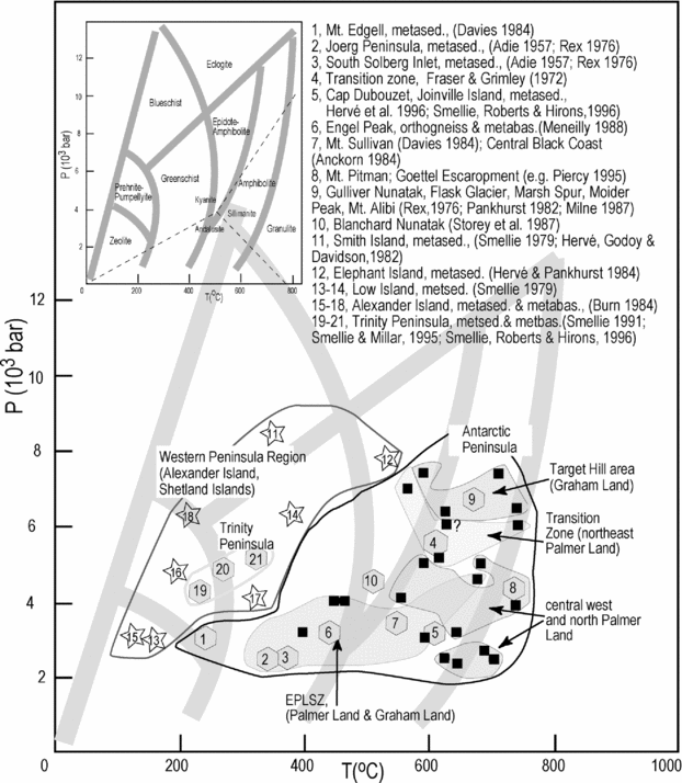
Figure 11. P–T diagram showing calculated P–T points and general metamorphic conditions (numbered symbols) as described in the literature for the entire Antarctic Peninsula region. Metamorphic conditions are grouped for the Antarctic Peninsula, the Trinity Peninsula and the western Peninsula region. Inset shows overview of general metamorphic facies.
The Antarctic Peninsula region is generally assumed to consist of two areas with rocks that experienced distinct metamorphic conditions (e.g. Smellie & Clarkson, Reference Smellie and Clarkson1975) preserving (1) a higher-pressure–lower-temperature outer area (west Antarctic Peninsula region), and (2) a low- to high-pressure–high-temperature inner area comprising the Antarctic Peninsula. In the following, we divided the Antarctic Peninsula region into sections that conform to the Smellie & Clarkson (Reference Smellie and Clarkson1975) model. We consider in detail (1) the West Antarctic Peninsula region, comprising the South Shetland Islands and Alexander Island, and (2) the Antarctic Peninsula, comprising the northern peninsula, Graham Land, Marguerite Bay, the transitional zone between Graham Land and Palmer Land, western Palmer Land and eastern Palmer Land. Geographical representations of locations are given in Figure 1.
5.a. Western Antarctic Peninsula region
5.a.1. South Shetland Islands
The South Shetland Islands extend NE–SW in a direction parallel to the northernmost part of the Antarctic Peninsula. They are separated from the peninsula by Bransfield Strait. The Elephant and Clarence Island groups and Smith Island form the northeastern and southwestern termination of the island chain, respectively, and are known to contain high-pressure low- to medium-temperature metasedimentary rocks of either pre-Jurassic (Smellie & Clarkson, Reference Smellie and Clarkson1975; Rivano & Cortes, Reference Rivano and Cortes1976) or mid-Tertiary age (Trouw, Simoes & Valladares, Reference Trouw, Simoes and Valladares1998). A subduction complex composed of ocean floor material mixed with arc-derived metasediments is known from the Elephant Island group and at Smith Island, with metamorphic ages of 120 Ma to 80 Ma and 58 Ma to 47 Ma, respectively (Trouw, Simoes & Valladares, Reference Trouw, Simoes and Valladares1998). In the Elephant Island group, metamorphic grades increase gradually in a southwest direction from the pumpellyite–actinolite facies to the lower amphibolite facies, with maximum pressures of 7.5 kbar and maximum temperatures of 525°C. Metasediments from Clarence Island, situated to the east of Elephant Island, were metamorphosed under greenschist-facies conditions (Hervé & Pankhurst, Reference Hervé and Pankhurst1984).
Further to the southwest, on Smith Island, metamorphic conditions belonged to the blueschist-facies with pressures up to 8 kbar for temperatures between 300°C and 350°C (Smellie, Reference Smellie1979; Hervé, Godoy & Davidson, Reference Hervé, Godoy, Davidson, Oliver, James and Jago1982). Twenty kilometres southeast of Smith Island, volcanic and sedimentary strata, intruded by felsic plutons, form Low Island (Smellie, Reference Smellie1979). Here, metamorphic conditions were considerably lower than elsewhere in the South Shetland Island region. Lower-grade metamorphism from zeolite-facies to the upper greenschist-facies affected sedimentary rocks (volcaniclastic and epiclastic) and suggested burial to depths of less than 10 km and maximum temperatures around 300°C to 350°C (Smellie, Reference Smellie1979). Parts of the low-grade metamorphic facies are characterized by an unusual mineral paragenesis of prehnite + calcite + chlorite + sphene (Smellie, Reference Smellie1979) that also exists in parts of the Fossil Bluff Group on Alexander Island (Taylor, Reference Taylor1967), and in New Zealand (Marakopa section: Coombs, Reference Coombs1961).
5.a.2. Alexander Island
Alexander Island is the largest of the chain of islands along the west coast of the Antarctic Peninsula. Steep-sided north–south-trending mountain ranges are composed of deformed metasedimentary rocks of the LeMay Group, a thick sequence of turbidites with metamorphic and volcanic derivations (Edwards, Reference Edwards and Craddock1982; Burn, Reference Burn1984). Alexander Island is considered to be a middle Triassic to middle Cretaceous accretionary complex dominated by arkoses derived from an eroded continental margin (e.g. Willan, Reference Willan2003). The deformation associated with a succession of low- to intermediate/higher-pressure metamorphism exhibited by some of the sedimentary materials suggest that they accumulated in a subduction-related setting, of probably Late Palaeozoic to Mesozoic age (Burn, Reference Burn1984; Thomson & Tranter, Reference Thomson and Tranter1986; Holdsworth & Nell, Reference Holdsworth and Nell1992).
In northern Alexander Island, the metamorphic grade of the LeMay rocks increases towards the northeast from zeolite- and prehnite–pumpellyite- (locally +actinolite) facies sandstones to muscovite–garnet schists, metamorphosed probably at greenschist-facies conditions (Burn, Reference Burn1984). Local developments of lawsonite (Burn, Reference Burn1984) and riebeckite (Burn, Reference Burn1984; Wendt, unpub. data) in metabasic lithologies in central Alexander Island (north Lully Foothills and southeast Colbert Mountains) indicated formation at intermediate-pressure–low-temperature conditions (low-P blueschist-facies).
To the west, the low/intermediate-pressure rocks of the LeMay Group are in fault contact with the volcanic rocks of basaltic–rhyolitic composition of the Colbert Mountains (Burn, Reference Burn1984). To the east, the LeMay Group is in fault contact with, and unconformably overlain by, the rocks of the Fossil Bluff Group (LeMay Range Fault: Bell, Reference Bell1975; Edwards, Reference Edwards1980), a thick succession of outer shelf to shelf deposits of a fore-arc basin (Taylor, Reference Taylor1982; Macdonald & Butterworth, Reference Macdonald, Butterworth and John1990).
5.b. Antarctic Peninsula
5.b.1. Northern Peninsula
Cape Dubouzet, located at the northernmost tip of the Antarctic Peninsula comprises extensive rock units of rhyolitic volcanic breccias (e.g. Hervé et al. Reference Hervé, Lobato, Ugalde and Pankhurst1996), intruded by dacite and rhyolite plutons, and mafic dykes. The dacite plutons contained numerous metamorphic xenoliths of unknown provenance (e.g. Loske et al. Reference Loske, Miller, Milne and Hervé1990), comprising metasediments (containing garnet + cordierte ± andalusite ± sillimanite), metabasites (amphibolites) and orthogneisses, probably metamorphosed at upper amphibolite-facies pressures and temperatures (Hervé et al. Reference Hervé, Lobato, Ugalde and Pankhurst1996). Age analyses of the orthogneissic material revealed Precambrian apparent ages for the protolith and Carboniferous apparent ages for the metamorphic overprint (Loske et al. Reference Loske, Miller, Milne and Hervé1990; Loske & Miller, Reference Loske and Miller1991). The amphibolite xenoliths revealed Late Jurassic/Early Cretaceous metamorphic ages (Loske & Miller, Reference Loske and Miller1991). East of Cape Dubouzet, at Hope Bay, a Carboniferous hornblende orthogneiss xenolith was observed in a Jurassic dacite (Loske & Miller, Reference Loske and Miller1991).
In the northern Antarctic Peninsula and in Joinville Island (e.g. Smellie, Roberts & Hirons, Reference Smellie, Roberts and Hirons1996; T. Riley, pers. comm. 2005), widespread, generally low-grade metamorphic sediments are known from the Permo-Triassic Trinity Peninsula Group. The regionally metamorphosed sedimentary sequences were assumed to form the local basement to the mainly Jurassic–Cretaceous Antarctic Peninsula magmatic arc (Smellie, Roberts & Hirons, Reference Smellie, Roberts and Hirons1996). The Trinity Peninsula Group has been suggested to be either a subduction complex or a fore-arc basin associated with a consuming plate margin (Hyden & Tanner, Reference Hyden and Tanner1981; Smellie, Reference Smellie1981, Reference Smellie and Mackenzie1987; Dalziel, Reference Dalziel1984; Storey & Garrett, Reference Storey and Garrett1985), or a back-arc basin, or the mid- to upper levels of an accretionary prism (Smellie, Roberts & Hirons, Reference Smellie, Roberts and Hirons1996). The rocks of the Trinity Peninsula Group mostly consist of mudstones and sandstones of predominantly turbiditic origin (Fleet, Reference Fleet1968; Hyden & Tanner, Reference Hyden and Tanner1981; Smellie, Reference Smellie, Thomson, Crame and Thomson1991). Their metamorphic grade and their deformation intensity increased generally in the southeasterly direction, from almost unaltered mudstones–sandstones to fully recrystallized schists (Aitkenhead, Reference Aitkenhead1975; Elliot, Reference Elliot1966; Hyden & Tanner, Reference Hyden and Tanner1981; Smellie, Reference Smellie, Thomson, Crame and Thomson1991; Kelm & Hervé, Reference Kelm and Hervé1994; Smellie, Roberts & Hirons, Reference Smellie, Roberts and Hirons1996). The gradual increase in metamorphism was derived from the analyses of metasediments (Smellie, Reference Smellie, Thomson, Crame and Thomson1991) and of metabasites (e.g. Hyden & Tanner, Reference Hyden and Tanner1981; Smellie, Reference Smellie, Thomson, Crame and Thomson1991). They showed an uninterrupted succession of prehnite–pumpellyite-, pumpellyite–actinolite- and greenschist-facies conditions with maximum temperatures of 300°C to 380°C at low to intermediate pressures (Smellie, Reference Smellie, Thomson, Crame and Thomson1991; Smellie & Millar, Reference Smellie and Millar1995; Smellie, Roberts & Hirons, Reference Smellie, Roberts and Hirons1996). The metasediments provided Late Permian/Early Triassic (metamorphic) ages (Smellie & Millar, Reference Smellie and Millar1995).
5.b.2. Graham Land
In Graham Land, metamorphic rocks were only observed in a few locations, mostly situated along the east coast. Here, deformed upper amphibolite-grade metamorphic orthogneisses, metabasites (amphibolites) and metasediments (Rex, Reference Rex1976; Pankhurst, Reference Pankhurst1982; Milne, Reference Milne1987) were reported to the west of Jason Peninsula. They were specifically recorded from Target Hill, Mount Lagado, Gulliver Nunatak, at Flask Glacier, Marsh Spur, Moider Peak and Mount Alibi (Pankhurst, Reference Pankhurst1982; Milne, Reference Milne1987). Geochronological analyses of orthogneisses from Target Hill showed crystallization of the igneous protolith in Middle Devonian times (Pankhurst, Reference Pankhurst1982; Milne & Millar, Reference Milne and Millar1989; Millar, Pankhurst & Fanning, Reference Millar, Pankhurst and Fanning2002). For the same rock, we obtained a high-amphibolite-facies metamorphic overprint with P–T conditions of up to 6.4 kbar at 735°C (R 4023.13), of late Early Carboniferous age (Millar, Pankhurst & Fanning, Reference Millar, Pankhurst and Fanning2002). For orthogneisses from Mount Lagado, we calculated high-pressure upper amphibolite-facies conditions with pressures of up to 7.4 kbar and temperatures of 588°C (R 4010.1), probably generated during the Early/Mid-Jurassic (A. J. Milne, unpub. Ph.D. thesis, Open Univ., 1990). Paragneisses were observed further east along Jason Peninsula, at Adie Inlet, included as rafts in a granitic gneiss complex with a Permian migmatization age (e.g. Rex, Reference Rex1976; Pankhurst, Reference Pankhurst1982; Millar, Pankhurst & Fanning, Reference Millar, Pankhurst and Fanning2002).
Further to the south, along the spine of the Antarctic Peninsula, we recorded orthogneisses and amphibolites from scattered outcrops along the east side of the Bruce and Avery Plateaux. Metamorphic conditions corresponded to upper greenschist- to lower amphibolite-facies with pressures of 4 kbar at temperatures of 460°C (R 8135.C, R 8137.N). Locally, higher temperatures of up to 650°C were also attained (R 8127.K). The orthogneisses might be derived from intraplutonic deformation of the extensive Triassic/Jurassic and mid-Jurassic plutonic suite (Millar, Pankhurst & Fanning, Reference Millar, Pankhurst and Fanning2002) that is exposed in the east of the plateau around Cole Peninsula. Their metamorphic grade would correspond to the temperature and pressure under which deformation took place.
Further to the southeast, lower-grade greenschist metamorphic sediments comprising slates, phyllites and pebbly horizons of probably pre-Jurassic age, were described at Joerg Peninsula and south of Solberg Inlet (Adie, Reference Adie1957; Rex, Reference Rex1976), along with some Triassic orthogneisses (M. J. Hole, unpub. Ph.D. thesis, Bedford College, Univ. London, 1986).
5.b.3. Marguerite Bay
Along the west coast of the Antarctic Peninsula, metamorphic rocks are known from different areas in Marguerite Bay (Pourquoi Pas Island, Horseshoe Island, Lagotellerie Island, Reluctant Island, Neny Fjord area). Orthogneisses and metasediments (e.g. Matthews, Reference Matthews1983a, b; Loske et al. Reference Loske, Hervé, Miller, Pankhurst and Ricci1997) were reported from various localities; on Pourquoi Pas Island, metamorphic rocks form gneissic fragments included in a thick succession of hypabyssal volcanic rocks (Matthews, Reference Matthews1983a). On Horseshoe and Reluctant islands, banded orthogneisses were reported to occur in situ derived from adjacent granitic to dioritic plutons by mylonitic deformation or synmagmatic flow (Loske et al. Reference Loske, Hervé, Miller, Pankhurst and Ricci1997) during Jurassic (Loske et al. Reference Loske, Hervé, Miller, Pankhurst and Ricci1997) or Late Triassic times (Millar, Pankhurst & Fanning, Reference Millar, Pankhurst and Fanning2002). On Horseshoe Island, metasediments occur as fine-grained black schists, quartz-mica schists and deformed conglomerates containing mainly volcanic and granitic components (Matthews, Reference Matthews1983a, b; Loske et al. Reference Loske, Hervé, Miller, Pankhurst and Ricci1997). On Horseshoe Island, highest metamorphic conditions were characterized by the complete recrystallization of quartz and feldspar in the presence of muscovite (Matthews, Reference Matthews1983b), indicating temperatures above 300°C. In the Neny Fjord area, schistose rocks appeared as xenoliths or rafts included in Jurassic granitic to dioritic orthogneiss (Adie, Reference Adie1954; Hoskins, Reference Hoskins1963; Gledhill, Rex & Tanner, Reference Gledhill, Rex, Tanner and Craddock1982; Pankhurst, Reference Pankhurst1982).
5.b.4. Transitional zone between Graham Land and Palmer Land
Metamorphic rocks have been described from various locations in the transitional zone between Graham Land and Palmer Land, which extends over 150 km in north–south direction (e.g. Macdonald & Butterworth, Reference Macdonald, Butterworth and John1990). These rocks comprised orthogneisses, metasediments and metabasites. Numerous orthogneiss and amphibolite outcrops were discovered between north of the Godfrey Uplands (P. Leat, pers. comm. 2005) and the Weyerhaeuser Glacier. Orthogneisses and amphibolites were also reported from south of Sunfix Glacier (Fraser & Grimley, Reference Fraser and Grimley1972) and around Hogmanay Pass (Fraser & Grimley, Reference Fraser and Grimley1972). We discovered metasediments (micaschists, slates and metaconglomerates, Fig. 5a–c) at Scripps Heights (R 8178.1, R 8179.1, R 8182.2, R 8182.7), and on the southeast side of Poseidon Pass (E 1457.1–8). Metasediments are also known from north of Grimley Glacier and from localities around Casey Inlet (Fraser & Grimley, Reference Fraser and Grimley1972). For the whole region, Fraser & Grimley (Reference Fraser and Grimley1972) suggested a general westward increase in metamorphism from greenschist- to low/mid-amphibolite-facies metamorphism. Our pressure and temperature analyses for areas relatively close by, revealed mid- to upper amphibolite-facies conditions with pressures of 7 kbar at 560°C (E 1644.7), and 9 kbar at 660°C (R 8141.D) for orthogneisses from the Weyerhaeuser Glacier and the Wakefield Highlands, respectively. Metamorphic basalts that we discovered in the Wakefield Highlands also belonged to the upper amphibolite-facies with pressures of 6 kbar at 735°C (R 8150.A). Towards the Scripps Heights, in a more coastal position, lower amphibolite-facies temperatures of >550°C were obtained for metasedimentary rocks (R 8179.2).
5.b.5. Western Palmer Land
In the northwestern corner of Palmer Land, low-grade metasediments of the prehnite–pumpellyite facies were observed in the area of Mount Edgell (Davies, Reference Davies1984); garnet-bearing metasediments were found at Boreas Peak (KG 1201.7). For these rocks, we calculated epidote–amphibolite-facies P–T conditions of 4 kbar, 550°C. Slightly further south, grey gneisses with Triassic/Jurassic migmatization ages were recognized at Orion Massif in northwest Palmer Land (Millar, Pankhurst & Fanning, Reference Millar, Pankhurst and Fanning2002). Banded Triassic migmatitic orthogneisses occur at Mount Eissenger in northwest Palmer Land (Millar, Pankhurst & Fanning, Reference Millar, Pankhurst and Fanning2002). Orthogneisses also occurred at the Campbell Ridges (Harrison & Loske, Reference Harrison and Loske1988; Harrison & Piercy, Reference Harrison, Piercy, Thomson, Crame and Thomson1992). East of the Campbell Ridges, at the Sirius Cliffs, a complex of dioritic to granitic orthogneiss was cut by undeformed granitic intrusions, and faulted against a thick succession of pyroclastic rocks. Migmatized metasediments (paragneisses) and orthogneisses were reported from Mount Lepus, Mount Pitman and the Goettel Escarpment (e.g. Piercy & Harrison, Reference Piercy, Harrison, Thomson, Crame and Thomson1991).
Generally, published regional pressure and temperature estimates for northwest Palmer Land vary around low-pressure conditions of the amphibolite–granulite-facies transition (S. M. Harrison, unpub. Ph.D. thesis, Council for National Academic Awards, 1989; Piercy & Harrison, Reference Piercy, Harrison, Thomson, Crame and Thomson1991; B. A. Piercy, unpub. Ph.D. thesis, Univ. London, 1995). For the orthogneisses from Mount Lepus, we obtained similar conditions with pressures and temperatures of the low-pressure granulite-facies (2.5 kbar at 620°C (R 3251.5); 2.3 kbar at 638°C (R 3253.1), and (higher temperature) mid-amphibolite-facies conditions (5 kbar at 589°C (R 3254.5); 5 kbar at 678°C (R 3250.5)).
In central west Palmer Land, at Auriga Nunataks, layered amphibolite- to granulite-facies grade biotite–garnet-bearing metasediments of probably pelitic origin (Harrison, 1989) and marble-hosted tectonic breccia (Harrison, 1989; Vaughan, Millar & Thistlewood, Reference Vaughan, Millar and Thistlewood1999) form the main part of the nunataks. For the orthogneisses of the northeast point of the nunatak, we calculated P–T conditions of low-pressure granulite-facies metamorphism (2.4 kbar at 694°C (R 2437.2); 3.8 kbar at 740°C (R 2436.3)), and we obtained a high-pressure upper amphibolite-facies overprint (7.3 kbar, 630°C) (R 2437.4) for the metasediments exposed in the eastern part of the nunataks.
Further south, at Fomalhaut Nunatak, in the eastern Pegasus Mountains, metasediments were metamorphosed under lowest-pressure granulite-facies conditions (1.5 kbar, 770°C; R 2535.12), probably related to plutonic activity prior to Early/mid-Jurassic times (Piercy & Harrison, Reference Piercy, Harrison, Thomson, Crame and Thomson1991). At Mount Markab, in the northern Pegasus Mountains, a large-scale ductile shear zone transected banded orthogneiss and amphibolite dykes. Extensional mylonitization within the shear zone occurred in the Early Cretaceous, affecting mid-Triassic granitic rocks (Millar, Pankhurst & Fanning, Reference Millar, Pankhurst and Fanning2002). In Gurney Massif, southwest Pegasus Mountains, we calculated that orthogneisses were metamorphosed at high-pressure upper amphibolite-facies conditions of 9.4 kbar 760°C (R 2523.1). However, amphibolitic rocks nearby only recorded a low-pressure amphibolite-facies to granulite-facies event (3.2 kbar, 640°C; R 2524.1).
5.b.6. Eastern Palmer Land
In northeast Palmer Land, west of the Eternity Range, small exposures of metasediments, including paragneisses and metapelites, were reported by Davies (Reference Davies1984); metasediments are also known from the eastern part of Mount Charity, south of the Eternity Range (A. Vaughan, unpub. data). Situated to the northeast of the Eternity Range is Mount Sullivan, which consists of deformed orthogneisses, amphibolites, gabbros, metasediments, including paragneisses and schists, and metamorphosed mafic dykes (Davies, Reference Davies1984; Vaughan, Kelley & Storey, Reference Vaughan, Kelley and Storey2002). Based on the presence of garnet, feldspar (plagioclase) and biotite, the orthogneisses were suggested to have undergone low-amphibolite-facies metamorphism (Davies, Reference Davies1984). Orthogneisses and sheeted metabasalts of at least greenschist-facies pressures and temperatures were observed at Engel Peaks, east of Mount Sullivan (Meneilly, Reference Meneilly1988). In the area between Mount Sullivan and Engel Peak, we discovered orthogneisses of mid-amphibolite-facies conditions (4.6 kbar, 677°C) (E 3607.2, NE Mt Sullivan). In general, deformation and metamorphism in northeast Palmer Land were interpreted to have taken place in Early/mid-Cretaceous times during intensive ductile faulting (Meneilly, Reference Meneilly1988).
Further south, a metamorphic complex is known from the area along the Black Coast. The so-called ‘central Black Coast metamorphic complex’ (Anckorn, Reference Anckorn1984) comprises two large metamorphic areas: (1) a northern part, situated between Anckorn Nunataks, Mount Samsel, the Eland Mountains and Mount Curl (Anckorn, Reference Anckorn1984); (2) a southern part, situated between the Welch Mountains, Mount Jackson, Mount Hill (Singleton, Reference Singleton1980), Musson Nunataks and Du Toit Mountains (Storey et al. Reference Storey, Wever, Rowley and Ford1987).
In the northern part of the ‘central Black Coast metamorphic complex’ (Anckorn, Reference Anckorn1984), orthogneisses and metasediments (paragneisses, quartz-mica schists) were the main rock types. They contained metamorphosed dioritic and doleritic dykes and were often in fault contact with dyke-free quartz–mica schists (Anckorn, Reference Anckorn1984). Based on the lack of almandine–garnet in the basic rocks and in the schists, they were assumed to be lower amphibolite-facies rocks (Anckorn, Reference Anckorn1984). Our calculations suggested similar conditions, with temperatures of >600°C (E 4043.5) for the schists.
Similar metamorphic rocks were described from the southern part of the ‘Black Coast metamorphic complex’ (Anckorn, Reference Anckorn1984). Metasediments (paragneiss) and quartz–mica schists and quartzites were reported from the northeast of the Welch Mountains and in the eastern part of the Mount Jackson massif, respectively. Orthogneisses were observed in the central to western Welch Mountains, and in the western part of Mount Jackson. Also, foliated amphibolitic dykes with a foliation concordant with that of the surrounding orthogneisses and metasediments were found in the Mount Jackson area (Singleton, Reference Singleton1980). East of the Welch Mountains and Mount Jackson, orthogneisses, amphibolites and metagabbros were described from the Guard Glacier area (Singleton, Reference Singleton1980).
Singleton (Reference Singleton1980) suggested for this part of the ‘central Black Coast metamorphic complex’ (Anckorn, Reference Anckorn1984) a regional lower amphibolite-facies metamorphism based on the presence of sillimanite + garnet in the metasediments of the northeastern Welch Mountains. Our analyses of quartz–mica schists and metapelites from the Welch Mountains revealed (low-P) amphibolite-facies pressures of 3 kbar at 400°C (R 2137.2, quartz + mica + chlorite) and 5.1 kbar at 615°C (E 4010.1, plagioclase + garnet + biotite). Sillimanite was absent from our samples of the Welch Mountains.
Further south, metasediments were reported from the southern Mount Hill area. They were slaty, hornblende–hornfels to lower amphibolite-facies metasediments that experienced estimated pressures of ≤4 kbar at temperatures of 200°C to 800°C (Singleton, Reference Singleton1980). These metasediments belong to the Mount Hill Formation, which is also exposed east of the Welch Mountains, at Giannini Peak (Singleton, Reference Singleton1980), east of Musson Nunatak, at Kamenev Nunatak, on Condor Peninsula, in the Beaumont Glacier area, and to the south and east of the Du Toit Mountains (e.g. Storey et al. Reference Storey, Wever, Rowley and Ford1987). We studied the metamorphic conditions of the metapelites from Condor Peninsula, west of Mount Showers. They contained garnet + cordierite + andalusite + biotite assemblages and belonged to the low-pressure amphibolite-facies with pressures of 3 kbar and temperatures of 600°C (R 4201.5). South of Condor Peninsula, highly deformed phyllitic metasediments were also recorded from Hjort Massif (Storey et al. Reference Storey, Wever, Rowley and Ford1987).
To the west of the Black Coast, towards the centre of the Antarctic Peninsula, foliated and sheared quartz diorites and amphibolites were exposed within Guthridge and Blanchard nunataks (Storey et al. Reference Storey, Wever, Rowley and Ford1987), characterized by low-pressure epidote–amphibolite-facies conditions.
6. Discussion and conclusions
In this paper, we used a three-fold approach based on mapping, geothermobarometric calculations and a literature review, in order to compile the type, distribution and grade of metamorphic rocks at peninsula scale for the Antarctic Peninsula region.
The mapping allowed us for the first time to provide a full overview of all locations from which metamorphic rocks are known at peninsula scale. Furthermore, it enabled us to distinguish the distribution of meta-sedimentary rocks of continental origin from the distribution of meta-igneous rocks. This was necessary for fingerprinting areas of continental affinity (e.g. the Eastern Domain), and to distinguish them from areas in which rocks were of magmatic and/or volcanic origin (e.g. the Central Domain). The geothermobarometric calculations quantified maximum burial and uplift depth for both the continentally derived metasediments and the metabasaltic rocks. They also quantified depth of deformation-related metamorphism for the main intrusive igneous rock types for each investigated region. Local spots of contact metamorphism related to the intrusion of granitoids were also detected, however, these were not taken into account for the derivation of a peninsula-wide metamorphic pattern. The translation of these results, combined with data obtained from the literature, into metamorphic facies, allows us to demonstrate the progression of metamorphic grades at peninsula-region scale. We summarize the calculated maximum pressure and temperature points, and the qualitative metamorphic conditions (where no P–T points were available from the literature) in Figure 11, and show their regional distribution in the map on Figure 12.

Figure 12. Map compiling the metamorphic facies as obtained in the present study. Pressures and temperatures for all rocks are expressed using the principal metamorphic facies after Holdaway (Reference Holdaway1971). Corresponding metamorphic ages are explained in the text. Identified shear zones in solid lines. Presumed faults in dashed lines. Light grey areas around the Antarctic Peninsula and Alexander Island represent ice shelves.
Due to the large amount of field data covering the Western, Central and Eastern domains of the Antarctic Peninsula region (after Vaughan & Storey, Reference Vaughan and Storey2000), the metamorphic progression was best observed for Alexander Island, Palmer Land and the Gondwana margin east of the Eastern Palmer Land Shear Zone (illustrated and synthesized in Figure 13). It is evident from Figures 10 to 12 that (1) pressure and temperature conditions for the western Peninsula region (Alexander Island and western Palmer Land) increase from west to east, and are characterized generally by a prehnite–pumpellyite–greenschist–blueschist series with an amphibolitic/granulitic overprint (in the eastward direction) in western Palmer Land; maximum burial and exhumation of up to 23 km was observed in metasediments from western central Palmer Land (see Fig. 10b). It is also clear that (2) along the eastern border of Palmer Land, metamorphic grades increase along the Eastern Palmer Land Shear Zone (after Vaughan & Storey, Reference Vaughan and Storey2000) from east to west, and are characterized generally by a prehnite–pumpellyite–greenschist–amphibolite-facies series. Maximum burial and exhumation of up to 16 km was observed in metasediments from eastern central Palmer Land (see Fig. 10b). Along the northern extension of the Eastern Palmer Land Shear Zone (Vaughan & Storey, Reference Vaughan and Storey2000) into central east Graham Land (Cole Peninsula), the amount of metamorphic data was limited, but allowed us to show that metamorphic conditions plotted in the greenschist field, which is coherent with observations further south along the Eastern Palmer Land Shear Zone (Vaughan & Storey, Reference Vaughan and Storey2000).

Figure 13. Scheme of terrane accretion in Palmer Land (after Musumeci, Reference Musumeci1999). Large-scale dextral transpression along the Eastern Palmer Land Shear Zone (EPLSZ) resulted from SW–NE-directed, NW-dipping oblique convergence (large black arrows) between the Western Domain (Alexander Island) and the Eastern Domain (Gondwana margin) of Vaughan & Storey (Reference Vaughan and Storey2000). The Eastern Palmer Land Shear Zone is suggested to be the surface expression of a crustal-scale shear zone (small grey arrows), along which deep crustal levels were exhumed during compression. Highest uplifts occurred in the western Central Domain, and in the northeast along the Eastern Palmer Land Shear Zone. Major fault boundaries (black solid lines), except for the Eastern Palmer Land Shear Zone, were mapped from a NOAA VHRR satellite image (after Maslanyj, 1987). Also shown are the main metamorphic areas, and areas where metasediments are exposed today. Colour coding as in Figure 12.
Further north between central Graham Land and Joinville Island, the sparse occurrence of metamorphic rocks (see Fig. 4) did not allow us to establish a regional progression pattern of metamorphic grades. However, from the results presented here, we can show that metamorphic conditions reached high amphibolite conditions in the area of the Target Hill subprovince, and low-pressure amphibolite conditions in Cap Dubouzet (e.g. Hervé et al. Reference Hervé, Lobato, Ugalde and Pankhurst1996; Smellie, Roberts & Hirons, Reference Smellie, Roberts and Hirons1996). The metamorphic overprint in both areas was dated as Carboniferous (Loske et al. Reference Loske, Miller, Milne and Hervé1990; Loske & Miller, Reference Loske and Miller1991; Millar, Pankhurst & Fanning, Reference Millar, Pankhurst and Fanning2002).
In Trinity Peninsula, pressures and temperatures belong to the prehnite–pumpellyite–greenschist series, and metamorphic conditions in Joinville Island were mainly described as belonging to the prehnite–pumpellyite facies.
The South Shetland Islands are generally characterized by a southwest increase in metamorphic conditions from zeolite–greenschist- to blueschist-facies conditions in the southern areas (Smellie, Reference Smellie1979; Hervé, Godoy & Davidson, Reference Hervé, Godoy, Davidson, Oliver, James and Jago1982), and by pumpellyite–actinolite- to amphibolite-facies metamorphism in the northern areas (Hervé & Pankhurst, Reference Hervé and Pankhurst1984; Trouw, Simoes & Valladares, Reference Trouw, Simoes and Valladares1998).
The metamorphic progressions observed from the western (e.g. Alexander Island) and the eastern (e.g. Gondwana margin) domains towards the central domain (Palmer Land) of the Antarctic Peninsula reveal probably a convergent margin setting with two fundamentally different types of tectonism. The high P–T series prehnite–pumpellyite–greenschist–blueschist with the amphibolitic/granulitic overprint in the western domain in front of the magmatic arc is typical for a subduction-related setting (e.g. Spear, Reference Spear1993). The medium P–T series prehnite–pumpellyite–greenschist–amphibolite observed along the Eastern Palmer Land Shear Zone (Vaughan & Storey, Reference Vaughan and Storey2000), which separates the Eastern Domain from the magmatic arc, is typical for a geologically more complex situation, involving magmatic arc terrane accretion with burial and exhumation of Gondwana sediments of up to 16 km in eastern central Palmer Land (Central Domain).
The new and compiled metamorphic data presented here are consistent with the terrane accretion model of Vaughan & Storey (Reference Vaughan and Storey2000), even if they do not provide a definitive confirmation of that model. Figure 13 summarizes the metamorphic data in the context of terrane accretion and collision, illustrating a situation shortly after major convergence had ceased, probably in the Late Cretaceous. The metamorphic data are consistent with oblique convergence between Alexander Island (the Western Domain), Palmer Land (Central Domain) and the Gondwana margin (the Eastern Domain). Oblique transpressional movement, as proposed by Vaughan & Storey (Reference Vaughan and Storey2000), is an appropriate mechanism to have induced burial and differential uplift with (1) exhumation and shearing of the highest pressure rocks from central western (up to 9.4 kbar) and from northeast (7 kbar to 9 kbar) Palmer Land, (2) the exhumation and shearing of low- to medium-pressure rocks in western Palmer Land and along the Eastern Palmer Land Shear Zone, and (3) shallower burial and subsequent exhumation of sediments of the Gondwana margin along the Eastern Palmer Land Shear Zone. In agreement with suggestions by Vaughan & Storey (Reference Vaughan and Storey2000), Vaughan, Pankhurst & Fanning (Reference Vaughan, Kelley and Storey2002), and Vaughan, Kelley & Storey (Reference Vaughan, Kelley and Storey2002), and based on the high-amphibolite-grade rocks exposed in central western Palmer Land, it is suggested that the Eastern Palmer Land Shear Zone is the surface expression of a northwest- to west-dipping, deep-level, high-temperature crustal shear zone extending below the western part of the Central Domain.
Acknowledgements
The authors wish to thank O. Vidal for discussion and support on geothermobarometry, C. Hayward for assistance with the microprobe, S. Dare for collecting some of the microprobe data, H. Blagbrough, M. Tabecki, D. Wilde and P. Greatbatch for rock and thin-section preparation. We would also like to acknowledge the reading of an earlier manuscript by I. Millar, and anonymous reviewers. Special thanks go to the field and air operation staff at Rothera Base and at BAS headquarters in Cambridge for logistical support, and to J. Bursnall and D. Routledge for field assistance. The authors would also like to thank N. Stevenson for field assistance, and ongoing patience. This is a contribution to the British Antarctic Survey core project Superterranes in the Pacific-Margin Arc (SPARC).


