Deep geological repositories (DGRs) have been accepted internationally for the permanent disposal of high-level radioactive waste (HLRW) (IAEA, 1997, 2003; Pan & Qian, Reference Pan and Qian2009; McEvoy et al., Reference McEvoy, Schofield, Shaw and Norris2016). They typically rely on a multi-barrier system consisting of a natural geological barrier and an engineered barrier system (SKB, 2004; Zhang, Reference Zhang, Wang and Su2006). As the natural geological barrier (i.e. the host rock) plays a critical role in ensuring the long-term safety of DGRs, several types of rocks have been considered as potential host rocks for DGRs, including granite, clay rocks, rock salt, tuffs and crystalline rocks in general (NEA, 2001; Yoshida et al., Reference Yoshida, Nagatomo, Oshima and Metcalfe2014; McMaster et al., Reference McMaster, Ram, Faris and Pownceby2018). Granite has been considered as a potential host rock for the DGRs in Sweden, Finland and China (Delay et al., Reference Delay, Lebon and Robours2010; Hudson et al., Reference Hudson, Cosgrove, Kemppainen and Johansson2011; Wang et al., Reference Wang, Hou, Zhang, Men and Wang2018).
Clay rocks are widely accepted as potential host rocks for DGRs due to their attractive properties, such as large rock mass, stable geological structure, low hydraulic conductivity, self-sealing potential of fractures and high sorption capacity for radionuclides (Zhang, Reference Zhang2018). Many studies have focused on the properties of clay rock, such as mineralogical composition (Gaucher et al., Reference Gaucher, Robelin, Matray, Negrel, Gros and Heitz2004; Zhang, Reference Zhang2018), water contents and permeability (Andra, 2005; Delay, Reference Delay, Trouiller and Lavanchy2006; Distinguin & Lavanchy, Reference Distinguin and Lavanchy2007), safety as a repository (Mazurek et al., Reference Mazurek, Gautschi, Marschall, Vigneron, Lebon and Delay2008; Cuss et al., Reference Cuss, Harrington, Giot and Auvray2014; Sasamoto et al., Reference Sasamoto, Isogai, Kikuchi, Satoh and Svensson2017) and effects of the clay types on bentonite (Kohno et al., Reference Kohno, Nara, Kato and Nishimura2018; Matusewicz & Olin, Reference Matusewicz and Olin2019), which may be used as an additional barrier. France and Switzerland plan to construct repositories in Callovo-Oxfordian (COX) clay and Opalinus (OPA) clay formations at depths of 420–550 m and 400–700 m below surface, respectively (NAGRA, 2002; Andra, 2015).
In 2009, nationwide screening started for clay rock sites in mainland China. Since then, four regions have been preliminarily identified as potential clay rock DGR candidate sites: (1) the Tamusu and (2) Suhongtu areas in the Inner Mongolia Autonomous Region; (3) the Longdong area in Guansu Province; and (4) the Nanbaxian area in the northwest of Qaidam Basin (Fig. 1a). In addition, basic criteria for the site selection of clay rock repositories in China have been developed by referencing standards from the International Atomic Energy Agency (IAEA) and experiences abroad (IAEA, 1997, 2003; Andra, 2005; Pan & Qian, Reference Pan and Qian2009; Liu et al., Reference Li, Liu and Liang2012). Based on the results of preliminary evaluations of socioeconomic conditions (Liu & Liu, Reference Liu and Liu2012; Guan et al., Reference Guan, Liu and Liu2014; Yang, et al., Reference Yang, Liu, Liu and Xiang2017) and basic mechanical properties (Wang et al., Reference Wang, Chen, Su and Zhao2018), the Tamusu area might be considered as a key candidate area for establishing a clay rock DGR.
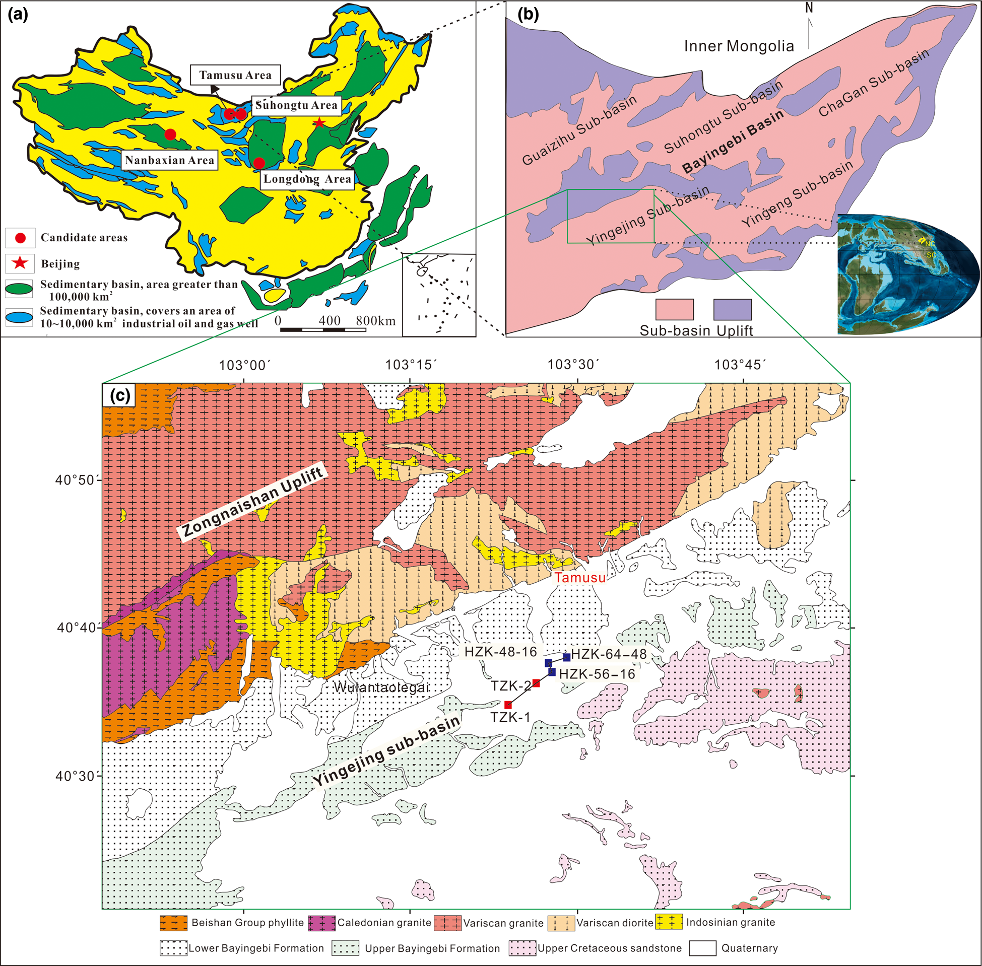
Fig. 1. (a) Location of the four preliminary candidate areas (after Liu et al., Reference Liu, Liu, Wang and Che2010). (b) The Cretaceous palaeogeography shows that the Bayingebi Basin is located in the orogenic zone between the Siberian and the North China blocks in the temperature zone. (c) Geological map of the Yingejing Sub-basin and borehole locations. The boreholes indicated by the red squares were drilled by the present team, whereas those indicated by the blue squares were drilled by Geological Team No. 208 (Wei & Jiang, Reference Wei and Jiang2019).
In this paper, the suitability of the target mudstone formation in the Tamusu region is discussed in the context of the results obtained from two test boreholes (borehole TZK-1 and borehole TZK-2) drilled in the area. The following topics are presented: (1) analysis of the spatial distribution of the characteristics of the target mudstone (geological homogeneity); (2) analysis of mineralogical characteristics; (3) analysis of in situ testing of the hydraulic conductivity via pulse tests; and (4) discussion of the suitability of the target formation as a host rock for DGR purposes.
Geological setting
The Bayingebi Basin
The Bayingebi Basin (Inner Mongolia, northwest China) is located in the southern margin of the Xingmeng Orogenic Belt (Lin et al., Reference Lin, Eriksson, Li, Wan, Ren and Zhang2001; Dou & Chang, Reference Dou and Chang2003) in the Eastern Central Asian Orogenic Zone (Zhou et al., Reference Zhou, Wilde, Zhang, Ren and Zheng2010), which is framed by the Siberian Craton and the North China Craton (Fig. 1b) (Charles et al., Reference Charles, Augier, Gumiaux, Monie, Chen, Faure and Zhu2013). This basin is a Mesozoic terrestrial rift basin that developed on the Palaeozoic fold basement and Precambrian crystalline bedrock (Wei et al., Reference Wei, Zhang and Chen2006; Wei & Jiang, Reference Wei and Jiang2019). The basement is composed primarily of Palaeozoic and early Mesozoic intermediate to felsic granitic plutons, mafic to felsic volcanic rocks and Proterozoic to Palaeozoic sedimentary or metasedimentary units (Meng et al., Reference Meng, Hu, Yuan and Jin2002; Zhang et al., Reference Zhang, Nie, Jiao, Deng, Peng and Hou2019). Triassic and Jurassic strata are only distributed in the northwest area of the basin and consist of fluvial and lacustrine sandstone, shale, mudstone and coal seams. The Cretaceous strata are divided into the Bayingebi, Suhongtu, Yingen and Wulansuhai formations. Cenozoic strata (alluvial and fluvial deposits) occur sporadically, and Cretaceous strata represent the main sedimentary covering of all sub-basins in the basin, which are composed of alluvial fans and lacustrine facies (consisting of conglomerates, sandstone, shale and sandy limestone).
Target formation
The Tamusu area, a key clay rock DGR candidate area for China's HLRW, is located in the northeast margin of the Yingejing sub-basin. The sub-basin is framed by the Zongnaishan and the Bayannuoergong uplifts, with northeast–southwest orientation (Fig. 1c). The Early Cretaceous Bayingebi formation is divided into the lower Bayingebi formation (K1b 1) and the upper Bayingebi formation (K1b 2) (Zhang et al., Reference Zhang, Nie, Jiao, Deng, Peng and Hou2019). Alluvial fan and fan delta systems developed mostly in the lower Bayingebi formation, consisting of red detrital rocks that underwent a maximum burial depth of ~1400 m. The sedimentary rocks of the upper Bayingebi formation contain sediments typical of alluvial fan, fan delta, braided delta and well-developed lacustrine facies. The target mudstone formation consists of a set of grey lacustrine mudstones comprising the upper Bayingebi formation (K1b 2), which was identified at a maximum depth of ~911 m.
Based on boreholes drilled earlier by Geologic Party No. 208 in the northeast of the sub-basin (Fig. 1c) and sedimentary research (Wu et al., Reference Wu, Zhou, Xu, Liu and Zhang2010; Deng, Reference Deng2013; Li, Reference Li2018; Wang et al., Reference Wang, Liang, Hu, Chen, Wang and Xie2018), the lacustrine, fan delta and braided delta facies comprise the upper Bayingebi formation. The target formation (K1b 2) consists of a succession of mudstone–sandstone–mudstone (Wang et al., Reference Wang, Hou, Zhang, Men and Wang2018). The lower mudstone unit is mainly composed of a grey–greyish white mudstone deposited in a semi-deep to deep lacustrine environment. The second sandstone unit comprises yellowish-brown sandstone, siltstone and grey mudstone, representing fan delta and braided delta plain sub-facies (Wu et al., Reference Wu, Zhou, Xu, Liu and Zhang2010). The third lithological unit is a thick grey–dark grey mudstone, which was formed in a semi-deep to shallow lacustrine environment. To delineate the southwest margin of the lacustrine basin and to define the occurrence of the target formation in the Tamusu area, the boreholes TZK-1 and TZK-2 were drilled between June and August 2017. This was the first time that test boreholes were drilled in the Tamusu area to conduct evaluations on the suitability of clay rock DRGs for China's HLRW. Borehole TZK-1, located in the southwest of the Tamusu area, contributed significantly to delineating the southwest margin of the lacustrine basin. The core lithology highlights the interbedded mudstone–sandstone–mudstone structure of the target formation (Fig. 2), which indicates that the depositional centre of the lacustrine basin is probably located in the northeast. In particular, the first unit with a maximum depth of ~200 m consists primarily of fine-grained sandstone and silty mudstone with thin argillaceous siltstone beds. The fine-grained sandstone is characterized by a massive structure and parallel bedding with a reddish-brown colour. The second unit (200–450 m) is composed mainly of interbedded fine-grained sandstones and argillaceous siltstone. The third unit (450–800 m) consists of dark grey mudstone (Fig. 2). Based on the lithological characteristics of the samples from borehole TZK-1 and earlier drilled boreholes (Fig. 1), borehole TZK-2 was drilled to explore the potential depositional centre of the lacustrine basin and the continuous thickness of the mudstone. The entire target formation consists of dark grey mudstone, which indicates that borehole TZK-2 was located close to the depositional centre of the lacustrine basin.

Fig. 2. Lithology and transmissivity of borehole TZK-1.
Materials and methods
Mineralogical analysis
Core samples were collected every 3 m in the field at depths between 381.82 and 800.60 m. A total of 116 core samples from borehole TZK-2 were vacuum sealed to maintain freshness. Then, the whole-rock samples were powdered to pass through a 200 mesh sieve prior to testing. Conventional X-ray diffraction (XRD) analysis was carried out on whole-rock powdered samples with Cu-Kα radiation operating at 40 mA and 40 kV (D8 ADVANCE, Bruker, Germany). Diffraction traces were recorded from 5 to 70°2θ and the semi-quantitative estimates of relative mass fractions were calculated using the Bruker Diffrac.EVA package. This method provides a semi-quantitative analysis, which, in the case of significant differences in the compositions of the samples, may provide meaningful values with an average precision of ~5%. These tests were completed in the State Key Laboratory of Nuclear Resources and Environment, East China University of Technology, China. To characterize the clay mineralogy, the clay fractions (<2 μm) of the samples were investigated using oriented mounts in the air-dried state after ethylene glycol solvation and after heating at 495°C. The preparation of the oriented mounts was conducted in the GeoResources Laboratory of the University of Lorraine, France. The XRD traces were recorded with Cu-Kα radiation operating at 2.2 kW using a D2 ADVANCE Bruker diffractometer. Diffraction patterns were recorded from 2 to 30°2θ and clay mineral relative contents were calculated based on ethylene glycol patterns and on Thierry (Reference Thierry1985). An absolute uncertainty of ± 5% remains even if many characteristic parameters of the minerals to be quantified are known (Reynolds, Reference Reynolds, Pevear and Mumpton1989). Dolomite and ankerite are difficult to distinguish by XRD, so a polarizing microscope in combination with alizarin red-S etching (Li et al., Reference Li, Liu and Liang2012) was applied by the Langfang (China) Shangyi Rock Mine Detection Technology Service Co., Ltd for this purpose. Structural characteristics and major minerals were investigated using a polarizing microscope.
Measurement of hydraulic conductivity
At the conclusion of the drilling stage, the hydraulic conductivities of boreholes TZK-1 and TZK-2 were tested in situ with pulse tests conducted using a heavy-duty double-packer (HDDP) system, which was operated with the help of the Beijing Research Institute of Uranium Geology (BRIUG). The HDDP system (Solexperts, Switzerland) consists of four independent components: equipment installed in the borehole; a data-acquisition unit; a water-stop packer pressure-control unit; and a flow-control unit (Fig. 3). In the HDDP system, the two water-stop packers could be pressurized or decompressed independently, which allowed a single packer test to be conducted while the other was pressurized. As a result, the mode of operation could be switched independently between double and single water-stop packer modes without the need to remove any of the down-hole devices. The data from the pulse test were curve-fitted using the Hytool analytical software.

Fig. 3. Technical setup of the HDDP system.
Results and discussion
Mineralogical characterization of mudstone
Microscopic analysis
The mudstone samples from the two boreholes contained typical structures, including stockwork, massive, ‘porphyritic-like’ and lamellar structures. In particular, the stockwork structure is characterized by thick, white, irregular strips connected by white veins that exhibit an interlaced reticular structure 1–6 mm in width (Fig. 4a). The white stockwork and veins are composed primarily of dolomite, ankerite, analcime and microcrystalline calcite mixed with dark argillite (Fig. 4b). The ‘porphyritic-like’ structure resembles a ‘snowflake’ in dark grey mudstone (Fig. 4c), and the typical rhombohedral coarse-grained dolomite is surrounded by dark argillite with particle sizes ranging from 0.5 to 1.0 mm (Fig. 4d). As the primary structure in the target formation, the massive structure is grey and dark grey, apparently homogeneous and highly consolidated (Fig. 4e). The laminar structures have thicknesses varying from 1 to 3 cm (Fig. 4f). Under plane polarized light, etched thin sections (alizarin red-S and potassium ferricyanide solution dyeing) appeared dark blue for ankerite, beige for coarse dolomite (undifferentiated) and grey–white for analcime with negative relief (Fig. 4g). It is worth noting that a high-angled gypsum interlayer was identified at a depth of 300 m in borehole TZK-2 (Fig. 4h).

Fig. 4. Typical structures in the Tamusu mudstone. (a) Stockwork structure, with marked white veinlets composed of analcime and dolomite, borehole TZK-2, 765 m. (b) Dark argillaceous structures mixed with evenly distributed powder-fine dolomite and analcime, plane polarized light. (c) ‘Porphyritic-like’ structure, marked large, white particles composed of fine-grained and coarse-grained dolomite in a fine-grained matrix, borehole TZK-1, 595 m. (d) Rhombic coarse-grained dolomite and fine-grained dolomite crystals are distributed in a dark clay matrix, plane polarized light. (e) Massive structure, borehole TZK-1, 520 m. (f) White and grey–white laminae developed in dark grey mudstone. (g & f) The marked regions are composed of dolomite, ankerite and analcime, borehole TZK-2, 137 m, dyed thin, plane polarized light. (h) Gypsum-containing mudstone, TZK-2, 144 m. Ana = analcime; Ank = ankerite; D1 = powder-fine dolomite; D2 = coarse-grained dolomite.
XRD analyses
The target mudstone formation is mainly composed of three mineral species: carbonates (dolomite and ankerite), albite and analcime. In addition, small amounts of evenly distributed clay minerals (mainly illite and kaolinite), quartz, calcite, hematite and pyrite are also present. Typical whole-rock XRD traces of two samples (T44 and T126) are shown in Fig. 5.

Fig. 5. XRD traces of typical whole-rock samples.
Carbonate minerals are abundant in all samples. In particular, the mass fractions of dolomite and ankerite ranged from 3 to 50% and from 4 to 25%, respectively, with average mass fractions of 28% and 13%, respectively. The mass fractions of analcime and calcite ranged from 1% to 43% and from 0.2% to 23%, respectively, with averages of 17% and 3%, respectively. Both analcime and calcite decreased rapidly with depth. The mass fractions of albite, quartz, hematite and pyrite were evenly distributed and ranged from 7 to 40%, 1 to 11%, 1 to 9% and 2 to 20%, respectively, with average values of 19%, 5%, 4% and 6%, respectively. The mass fractions of illite and kaolinite ranged from 2 to 6% and from 1 to 4%, respectively, with average mass fractions of 3% and 2%, respectively. In addition, the relative abundances of clay minerals after ethylene glycol solvation were investigated preliminarily (Fig. 6). T1 (at 50 m depth, TZK-2) is composed of illite (63%), kaolinite (8%), chlorite (7%) and smectite (22%), and T18 (at 515 m depth, TZK-2) is composed of illite (96%) and chlorite (4%), confirming that the main clay mineral is illite. Analcime and dolomite were also detected in the clay fractions, suggesting a small particle size for these minerals.

Fig. 6. Oriented XRD traces of ethylene glycol-solvated <2 μm clay fractions of the T1 and T18 samples.
Based on the whole-rock mineralogical analysis of 116 samples, three facies could be distinguished (Fig. 7). The first facies (381.82–528.77 m, above Line E–F) is composed mainly of analcime, carbonate minerals and albite, with analcime being the most abundant. The second facies (528.77–723.79 m, between Line E–F and Line M–N) consists mainly of carbonate minerals, analcime and albite. The third facies (723.79–800.06 m, below Line M–N) is composed mainly of carbonate minerals and albite, showing the smallest analcime content.
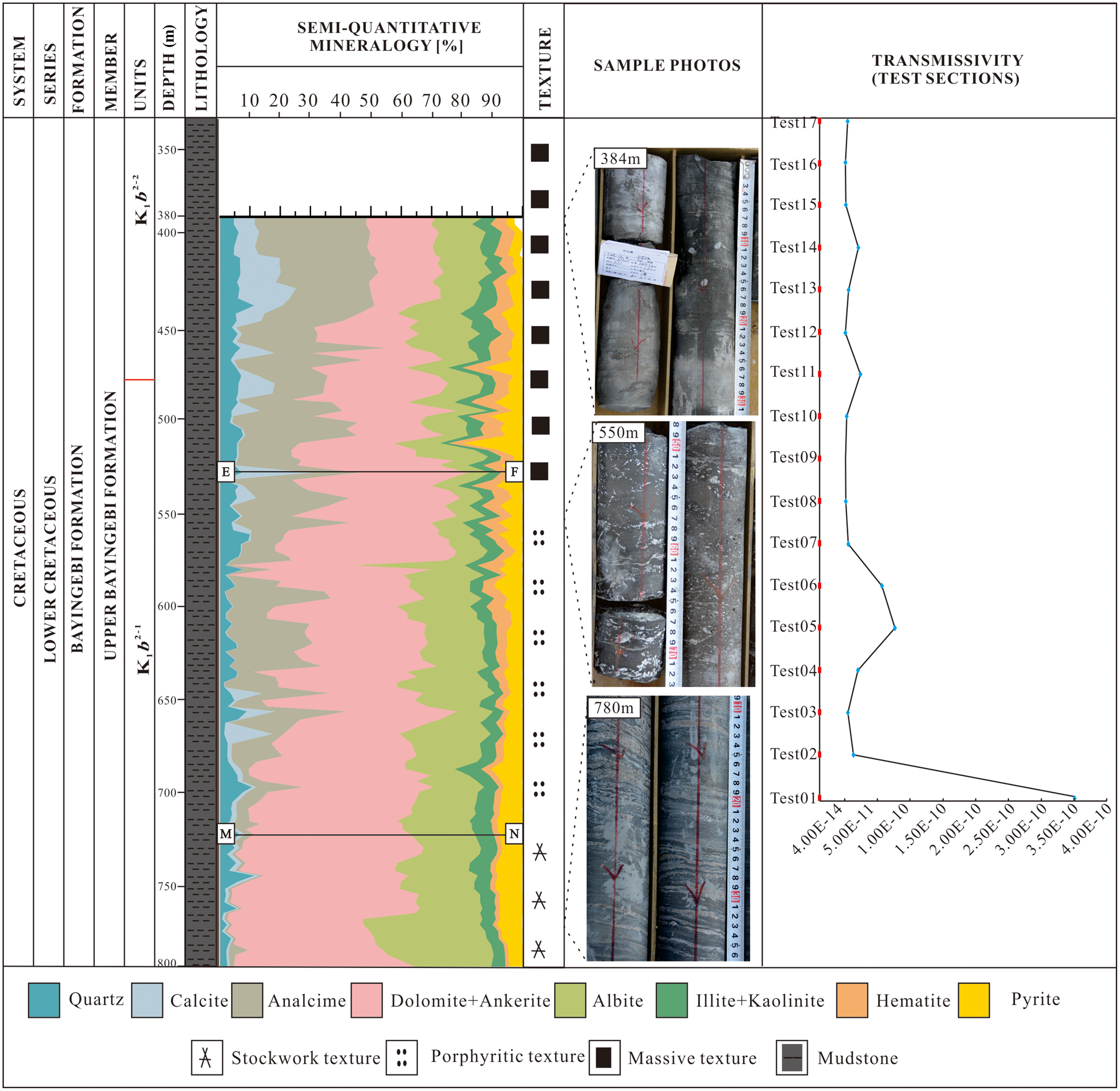
Fig. 7. Minerals and transmissivities of the samples from borehole TZK-2.
Shale classification triangles (Zhong et al., Reference Zhong, Yang, Sun and Zhang2018) were applied to compare the Tamusu mudstone with other target DGR rocks (Fig. 8). The COX and OPA clays have various clay/carbonate ratios. In contrast, the clay content of the Tamusu mudstone is low. However, if analcime is considered instead of clay minerals in the triangle plot, the analcime/carbonate ratio determines the mineralogical variability of the Tamusu mudstone, in analogy to COX and OPA clays (Zhong et al., Reference Zhong, Yang, Sun and Zhang2018). No data points were observed in the siliceous mudstone area (area E, Fig. 8). The COX clay and Tamusu mudstone are mainly characterized as mixed mudstones (area D1, Fig. 8), with the clay mineral content being generally higher in OPA clays. The triangular diagram does not reflect the type of carbonate, which may be used for additional characterization. The carbonate minerals of Tamusu mudstone are dominated by dolomite and ankerite, whereas calcite dominates in COX and OPA clays. Overall, the Tamusu mudstone, in contrast to COX and OPA clays, contains zeolites that may play a role with respect to radionuclide retention, as discussed in the case of the Yucca Mountain potential host rock (Bish, Reference Bish1999) and for low- and intermediate-level short-lived radioactive waste in Belgium (Misaelides, Reference Misaelides2019). The large carbonates contents may affect the mechanical stability positively (Wang et al., Reference Wang, Hou, Zhang, Men and Wang2018). On the other hand, the small clay minerals contents, at least in comparison with COX and OPA clays, may lead to a reduced ability to seal cracks. Moreover, the Tamusu groundwater containing Ca2+ and Mg2+ may play an important role in the retention of selenite (Heberling et al., Reference Heberling, Vinograd, Polly, Gale, Heck and Rothe2014; Sun et al., Reference Sun, Renew, Zhang, Tang and Huang2017), which indicates that Tamusu mudstone in groundwater conditions may be more effective at immobilizing Se-79 compared to Beishan granite (He et al., Reference He, Jun, Dong, Li, Zhao and Wang2019). Finally, the presence of carbonates might also contribute to the immobilization of Sr2+ (Dong et al., Reference Dong, Wang, Zhao, He, Jia and Liu2018).

Fig. 8. Classification triangle diagram of Tamusu mudstone, COX clay and OPA clay based on Zhong et al. (Reference Zhong, Yang, Sun and Zhang2018). (a) Tamusu data points; (b) COX and OPA data points. The COX clay data are from Gaucher (Reference Gaucher, Robelin, Matray, Negrel, Gros and Heitz2004) and the OPA clay data are from Ould Bouya (Reference Ould Bouya2014). QFM = quartz + feldspar + mica.
However, the advantages and disadvantages of the Tamusu mudstone compared to other DGR rocks remain to be assessed carefully in the future.
Hydraulic conductivity of mudstone
Determining the hydraulic properties of low-permeability environments is an arduous task due to operational constraints, equipment performance and the complex physical processes (Lavanchy et al., Reference Lavanchy, Croise, Tauzin and Eilers1998). The HDDP system has been used frequently in Beishan granite, and a relatively complete technical test scheme of borehole hydraulic conductivity has therefore been established, which effectively guarantees the smooth completion of pulse tests (Ji et al., Reference Ji, Zhang, Zhou and Li2018). Furthermore, the applicable scales summarized from various test methods for low-permeability rocks indicate that the pulse tests have wider applicability to low-permeability formations, even in the range of 10–14–10–9 m s−1 (Mejías, Reference Mejías2005). However, the ‘skin effect’ and short duration of a pulse test could not be avoided completely, and therefore these may affect the transmissivities obtained (Moench & Hsieh, Reference Moench and Hsieh1985; Connell, Reference Connell1994). To address this possibility, the test data were acquired between the point of closing the valve and executing the test after waiting for the system to stabilize over the course of several hours and up to several days. In addition, it is known that slight variations in the lower packer volume during a pulse test may increase the water head in the lower test sections (Fig. 9). For this reason, the observations in both the test section and the lower test sections were completed simultaneously during the pulse test. Some of these tests were conducted to confirm the proper operation of the instrumentation, and they included exposing the test valve to various pressures and using various types of pressure sensors. However, it was difficult to interpret the results of these limited tests. A total of 32 sets of pulse tests were conducted. These included 14 groups of tests for borehole TZK-1 to obtain 28 sets of transmissivities from 418.24 to 753.85 m and 18 groups of tests for borehole TZK-2 to obtain 24 sets of transmissivities from 280.85 to 712.21 m.

Fig. 9. Waterhead pressure–time response curve of Test02 in the test section of borehole TZK-1.
Hydraulic conductivity characteristics of borehole TZK-1
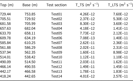
A total of 28 sets of transmissivity values were obtained from the test sections and the lower test sections. All of the transmissivities obtained were <10–10 m2 s−1 (Table 1), which could be converted to a hydraulic conductivity of <10–12 m s−1 (the length of the test section was 24.41 m). The hydraulic conductivities in the test sections (Fig. 10a) and lower test sections (Fig. 10b) were typically <10–11 m s−1, but varied from 10–12 to 10–10 m s−1. Based on the China Code for the Engineering Geological Investigation of Water Resources and Hydropower (GB50487-2008; Ministry of Water Resources, 2009), micro-permeability refers to rocks with hydraulic conductivities ranging from 10–8 to 10–7 m s−1, and ultra-low permeability refers to rocks with hydraulic conductivities <10–8 m s−1. Therefore, it was concluded that the Tamusu mudstone in the test sections of borehole TZK-1 exhibited the characteristics of ultra-low-permeability rocks.

Fig. 10. Statistical chart of the hydraulic conductivities of the test sections in borehole TZK-1.
Table 1. Transmissivities of the various test sections in borehole TZK-1.

T_LTS = transmissivities of the lower test section; T_TS = transmissivities of the test section.
The transmissivities of test sections Test06 to Test01 from borehole TZK-1 were less, by nearly an order of magnitude, than test sections Test07–Test13. In particular, the test sections at <600 m had lower transmissivities than those of the interbedded structure of mudstone–sandstone–mudstone (Fig. 2), which indicates that the distinct lithology had a noticeable effect on the transmissivities, even though there were no visible changes in the transmissivities in the relatively consistent rock sections.
Hydraulic conductivity characteristics of borehole TZK-2
The data obtained from borehole TZK-2 test sections were processed in the same way as those of borehole TZK-1, and the corresponding transmissivities were obtained from the lower test sections as the quality of the data there was higher. In total, 18 sets of transmissivities were obtained from the test sections and six sets were obtained from the lower test sections (Table 2).
Table 2. Transmissivities of the various test sections in borehole TZK-2.
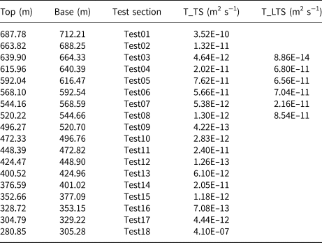
T_LTS = transmissivities of the lower test section; T_TS = transmissivities of the test section.
Test section Test18 between 280.85 and 305.28 m in depth had a transmissivity of 4.1 × 10⁻⁷ m2 s−1, which is >10–10 m2 s−1 (Table 2), and may have been caused by a potentially silty mudstone formation. The transmissivities of the other test sections were <10–10 m2 s−1, which correspond to hydraulic conductivities of <10–11 m s−1 (length of test section: 24.43 m). Similarly to borehole TKZ-1, the borehole TZK-2 test sections contained rocks with ultra-low permeability. The hydraulic conductivity was typically 10–12 m s−1 and ranged from 10–13 to 10–9 m s−1, which also indicates that the mudstone exhibited ultra-low permeability (Fig. 11a). It was confirmed that the rocks in the lower test sections were of ultra-low permeability, as the hydraulic conductivities ranged from 10–13 to 10–10 m s−1 (Fig. 11b). Hence, the pulse tests performed using the HDDP system confirmed the ultra-low permeability of the rock in the Tamusu mudstone. As the consistent lithology of the mudstone ranged from 300 to 700 m in borehole TZK-2, there were no visible fluctuations in the transmissivities with depth. Test sections from Test06 to Test01 had transmissivities that were an order of magnitude larger than those from Test17 to Test07, which indicates lower transmissivities in the latter test sections (from 304.79 to 568.10 m).

Fig. 11. Statistical chart of the hydraulic conductivities of the test sections in borehole TZK-2.
In 2014, exploratory experiments to determine the hydraulic conductivity of Tamusu mudstone were conducted using a rock mechanics test system (MTS815.04, MTS Systems Corporation, USA; Hu, Reference Hu2014). These results are in agreement with those obtained in the present study. The hydraulic conductivity obtained via in situ tests is consistent with the published laboratory results. These hydraulic conductivity results are consistent with the values reported in the literature for argillaceous formations in other locations. For example, hydraulic conductivities were reported between 10–14 and 10–12 m s−1 for OPA and COX clays, respectively (Andra, 2005; Delay et al., Reference Delay, Trouiller and Lavanchy2006; Distinguin & Lavanchy, Reference Distinguin and Lavanchy2007), and between 10–13 and 10–11 m s−1 for Toarcian argillite in Tournemire (Boisson et al., Reference Boisson, Bertrand, Heitz and Moreau-le Golvan2001).
The transmissivities were compared with the mineralogical composition of the various rock types. The test sections with lower transmissivities were those mudstone samples that featured massive structures and relatively high analcime mass fractions (mainly above Line E–F) (Fig. 7). The reason for this relationship is not known. Between 1994 and 2004, Andra collected hydraulic data related to argillite from deep boreholes obtained from short-term hydraulic packer tests and long-term monitoring of the formation pressures, which also confirmed that the hydraulic conductivity did not exhibit a distinct trend with depth for the COX clay (Distinguin & Lavanchy, Reference Distinguin and Lavanchy2007). It is often difficult to explain the various transmissivities because microstructural aspects have to be considered. The role of analcime with respect to the transmissivity of the Tamusu mudstone needs to be investigated further.
In general, in this ultra-low-permeability rock, an order of magnitude difference can be seen in the Tamusu mudstone transmissivities for varying lithologies, whereas no fluctuations were observed in the transmissivities for various depths for consistent lithology.
Spatial distribution conditions
The spatial distributions of mudstone in the upper Bayingebi Formation were analysed using well ties and shallow seismic profiles. The seismic data with calibrated stratigraphic boundaries were provided by the Remote Sensing Center of Nuclear Industry, China National Nuclear Corporation (CNNC). In combination with borehole lithology histograms from Geologic Party No. 208, the spatial distribution of mudstone can be determined by analysing the northeast–southwest well ties (Fig. 12). In particular, the semi-deep and deep lacustrine facies developed during the deposition of the first lithological unit (K1b 2-1). Near the depositional centre of the basin, the entire borehole TZK-2 consists of dark grey mudstone. A layer of continuous grey mudstone was identified from the lithology histograms at a burial depth of between 500 and 800 m. Then, influenced by tectonic movements and a dryer climate during the deposition stages of the second (K1b 2-2) and third lithological units (K1b 2-3), the lacustrine basin shrank as clastic sediments were deposited, reflecting a fan delta front, braided delta plain sub-facies and a shallow lacustrine environment. It is worth noting that sections of grey mudstone were identified in the samples from boreholes TZK-2, ZKH56-15 and ZKH64-48 at burial depths of between 100 and 300 m. Based on the continuous thickness of the COX clay (130 m) in France and the OPA clay (131 m) in Switzerland (Mari & Yven, Reference Mari and Yven2014; Bossart et al., Reference Bossart, Bernier, Birkholzer, Bruggeman, Connolly and Dewonck2017), it was surmised that the thickness of the continuous target formation in the Tamusu area may be >300 m because of the unexposed base of the target formation (K1b 2). More importantly, the spatial distribution (i.e. the continuous thickness and burial depth) was suitable as a host rock for a DGR.

Fig. 12. Northeast–southwest well tie sections in the Tamusu candidate region. J+Pz = Jurassic + Palaeozoic.
Conclusions
1. The spatial distribution features of the target formation were determined to have a continuous thickness of >300 m and a suitable burial depth. The southwest margin and depositional centre were well delineated by boreholes TZK-1 and TZK-2, respectively.
2. Three main mineral types were identified in Tamusu mudstone (carbonates, analcime and albite) and three facies were distinguished based on mineral abundance. The Tamusu mudstone contains fewer clay minerals than the COX and OPA clays, but more carbonate phases, which may result in increased mechanical stability, but less potential for sealing cracks. Analcime may contribute to radionuclide immobilization by adsorption, at least of cationic radionuclides. The specific advantages and disadvantages resulting from the specific properties of the Tamusu mudstone remain to be assessed in the future.
3. The Tamusu mudstone was confirmed to consist of ultra-low-permeability rocks. Distinct lithologies may affect the hydraulic conductivity of the rock, although no fluctuations with depth were observed for consistent lithology.
Based on the results of this study, it was concluded that the target formation in Tamusu mudstone might be suitable as a host rock for the clay rock DGRs of China's HLRW. The findings of this work are expected to provide a solid basis for further assessment. In terms of future work, more parameters of Tamusu mudstone, such as adsorption, diffusion, swelling for closing cracks and mechanical workability, among others, remain to be investigated.
Acknowledgements
The authors are very grateful to the editors and two anonymous reviewers for their constructive comments and suggestions, which improved the paper significantly. They also express their gratitude to Geological Team No. 208 and the Remote Sensing Center of Nuclear Industry, CNNC, for their support and assistance during the field visit and data collection. In particular, they are grateful for the guidance with the XRD analysis to Dr Michel Cathelineau and Dr Daniele Bartier of the University of Lorraine.
Financial support
This publication was funded by the State Administration of Science, Technology and Industry for National Defense (Two Division of Technology and Industry, [2014] 1587), Jiangxi Province Graduate Innovation Funding Project (YC2018-B083) and Jiangxi Province Post-Doctoral Scientific Research Project (2018KY42).