INTRODUCTION
The Qilian Shan are located in an area that is transitional between the Asian summer monsoon and the westerly circulation. Based on modern precipitation processes, pressure field, height field, and water vapor transport in the eastern Qilian Shan, this area is affected by the Asian summer monsoon (Li et al., Reference Li, Wang, Chen, Li, Zhou and Zhang2012; Chen et al., Reference Chen, Huang, Jin, Chen, Chen and Chen2018). However, the westernmost part of the Qilian Shan is a typical westerly circulation–affected region, as indicated by the water vapor flux vectors (Chen et al., Reference Chen, Yu, Yang, Ito, Wang, Madsen and Huang2008, Reference Chen, Huang, Jin, Chen, Chen and Chen2018). These research results indicate that significant differences in modern precipitation processes and mechanisms exist between the eastern and western Qilian Shan and that the modern northwestern edge of the Asian summer monsoon water vapor transport is located in the eastern Qilian Shan (Chen et al., Reference Chen, Yu, Yang, Ito, Wang, Madsen and Huang2008; Li et al., Reference Li, Wang, Chen, Li, Zhou and Zhang2012). According to modern climate studies (Chen et al., Reference Chen, Yu, Yang, Ito, Wang, Madsen and Huang2008; Li et al., Reference Li, Wang, Chen, Li, Zhou and Zhang2012), the Jiudong subbasin (Fig. 1) adjacent to the central regions of the North Qilian Shan is mainly controlled by the westerly winds, and the Asian summer monsoon water vapor transport cannot reach the drainage basin, but the whole subbasin is near the Asian summer monsoon limit (Chen et al., Reference Chen, Yu, Yang, Ito, Wang, Madsen and Huang2008, Reference Chen, Huang, Jin, Chen, Chen and Chen2018; Wang et al., Reference Wang, Chen, Huang and Zeng2017). Paleoclimatic records from the Jiudong subbasin are therefore critical for understanding the history and mechanisms of climate change in the arid and semiarid areas of NW China (An, Reference An2000); specifically, they are important for determining whether the East Asian summer monsoon (EASM) penetrated into the central regions of the North Qilian Shan during the Quaternary. Previous analyses of pollen assemblages, CaCO3 content, and redness and grain size from the sediments of Jiudong subbasin (Yanchi section in Fig. 1) indicated that the EASM penetrated into the central regions of the North Qilian Shan in the past (Li et al. Reference Li, Wang, Li, Zhou and Zhang2013; Yu et al., Reference Yu, Cheng and Hou2014, Reference Yu, Colman and Li2015). However, these studies were focused mainly on the Holocene, and longer records, spanning the Quaternary, are limited. The lack of long and continuous sedimentary records from the area has impeded paleoclimatic research of the transitional zone of the EASM and the westerlies. A sedimentary record from the Jiudong subbasin since ~1.8 Ma was presented previously (Pan et al., Reference Pan, Chen, Hu, Cao, Chen and Mao2016), and the sediments clearly offer the opportunity to reconstruct the long-term climatic evolution of the area.

Figure 1. (color online) Location of the NE Tibetan Plateau and the study area. DWJ denotes the location of the drill core DWJ site. a∆, Wenshu Shan; b∆, Yumu Shan; c∆, Dahuang Shan; LSS, Longshou Shan; HLS, Heli Shan; JTNS, Jintanan Shan; NQF, North Qilian Shan fault; NYF, North Yumu Shan fault; SHF, South Heli Shan fault; SLF, South Longshou Shan fault; NJF, North Jintanan Shan fault.; YLX, Yingluoxia Hydrologic Station; LYB, Liyuanbao Hydrologic Station; ZYX, Zhengyixia Hydrologic Station; YC, Yanchi Section (Li et al., Reference Li, Wang, Li, Zhou and Zhang2013).
Clay minerals are widely distributed—occurring in marine, eolian, lacustrine, and atmospheric environments, as well as in paleosols and sedimentary basins—which makes them useful for regional paleoenvironmental reconstruction. Their fine particle size and crystalline structure make them sensitive to weathering and diagenetic (especially pedogenic) transformations, and thus they are excellent archives of paleoenvironmental information (Moore and Roynolds, Reference Moore and Reynolds1989; Huyghe et al., Reference Huyghe, Guilbaud, Bernet, Galy and Gajurel2011; Zeng et al., Reference Zeng, Song, An, Chang and Li2014; Song et al., Reference Song, Zhang, Zhang, Ji, Hong, Wei, Xu, Algeo and Wang2018). Clay minerals are either primary/detrital minerals inherited from parent rocks by physical erosion and chemical weathering or secondary/authigenic minerals produced by pedogenesis and diagenesis (Huyghe et al., Reference Huyghe, Guilbaud, Bernet, Galy and Gajurel2011; Varga et al., Reference Varga, Gábor and Béla2011). Detrital clay minerals can only be used for reconstructing climatic conditions within the source area, while authigenic clay minerals provide records of the climate of the area of deposition (Chamley, Reference Chamley1989; Fagel et al., Reference Fagel, Boski, Likhoshway and Oberhaensli2003; Hong et al., Reference Hong, Li, Xue, Zhu, Zhang and Xiang2007; Huyghe et al., Reference Huyghe, Guilbaud, Bernet, Galy and Gajurel2011; Zeng et al., Reference Zeng, Song, An, Chang and Li2014; Song et al., Reference Song, Zhang, Zhang, Ji, Hong, Wei, Xu, Algeo and Wang2018). Thus, the clay mineral assemblages of sedimentary sequences can potentially yield records of past climatic conditions, provided the origin of the clay mineral assemblages (whether detrital or diagenetic) can be evaluated.
In this study, we investigated changes in the clay mineral assemblages of the sediments from Jiudong subbasin, using X-ray diffraction (XRD) and scanning electron microscopy (SEM). Our aims were to determine whether the clay mineral assemblages were of detrital or diagenetic origin and to obtain a better understanding of the paleoclimatic evolution of the Jiudong subbasin or central region of the North Qilian Shan since ~1.8 Ma.
Regional setting and drill core DWJ
The Hexi Corridor is located in the northern piedmont of the Qilian Shan (Fig. 1) and has an average elevation of ~1500 m. From northwest to southeast, the Wenshu Shan, Yumu Shan, and Dahuang Shan divide the Hexi Corridor into four subbasins: Jiuxi, Jiudong, Zhangye, and Wuwei (Fig. 1) (EGPGYO, 1989; Fang et al., Reference Fang, Zhao, Li, Yan, Pan, Song and Dai2005; Wang et al., Reference Wang, Zhang, Pang, Garzione, Zhang, Liu, Zheng, Zheng and Yu2016). The Jiudong subbasin is constrained by the North Qilian Shan to the south, and the Jintanan Shan–Heli Shan to the north (Fig. 1). The annual rainfall is 80–130 mm (Pan et al., Reference Pan, Chen, Hu, Cao, Chen and Mao2016), with 60% concentrated in June, July, and August. The annual pan evaporation is more than 1900 mm (Chen and Qu, Reference Chen and Qu1992), and the annual temperature is approximately 7°C–8°C (Pan et al., Reference Pan, Chen, Hu, Cao, Chen and Mao2016). Modern hydrological observations (Table 1) show that sediment discharge in the Yingluoxia hydrologic station (located in the middle and upper transition zones of the Heihe River) (Fig. 1) is about 2.697 million t/yr, sediment discharge in the Liyuanbao station (Fig. 1) is about 0.465 million t/yr, and sediment discharge in the Zhengyixia hydrologic station (located in the middle and downstream transition zones of the Heihe River) (Fig. 1) is about 1.630 million t/yr (Pan et al., Reference Pan, Geng, Hu, Sun and Wang2010; Cui et al., Reference Cui, Chen, An and G2015). Results of sediment discharges in the three stations indicate that about half of the sediment is currently deposited in the Zhangye–Jiudong subbasin.
Table 1. The tabulation of the coordinate, discharge, and record history for hydrological stations in the study area.

The Jiudong subbasin contains a sequence of Quaternary sediments with a thickness exceeding 1 km (Bovet et al., Reference Bovet, Ritts, Gehrels, Abbink, Darby and Hourigan2009; Li et al., Reference Li and Yang1998). From bottom to top, the Quaternary strata consist of two units: the Yumen (Q1) and Jiuquan Formations (Q2–Q3) (Fang et al., Reference Fang, Zhao, Li, Yan, Pan, Song and Dai2005; Zhu et al., Reference Zhu, Wang, Zheng, Xiang, Yi and Liu2006; Liu et al., Reference Liu, Fang, Song, Dai, Zhang, Zhang, Miao, Liu and Wang2010a). The Yumen Formation is characterized by conglomerate at the southern edge of the basin (Fang et al., Reference Fang, Zhao, Li, Yan, Pan, Song and Dai2005), and by fluvio-lacustrine fine conglomerate to mudstone in the basin center (Wang, Reference Wang1990); and the Jiuquan Formation is dominated by gravel beds (Fang et al., Reference Fang, Zhao, Li, Yan, Pan, Song and Dai2005).
Drill core DWJ (39°29′26.4″N, 99°36′19.2″ E, 1338 m above sea level) was obtained on the floodplain within the Jiudong subbasin (Fig. 1). The core reached a depth of 140 m, and the recovered length is ~125.25 m (Pan et al., Reference Pan, Chen, Hu, Cao, Chen and Mao2016). The sediments are poorly cemented and loose textured. The sedimentary sequence of core DWJ was divided into three lithological units that reflect the infilling of the Jiudong basin. From bottom to top (Pan et al., Reference Pan, Chen, Hu, Cao, Chen and Mao2016) (Fig. 2), they are:
Unit 1. 140–133.2 m (1.75–1.68 Ma): This unit consists dominantly of laminated silty clay and clayey silt and is interpreted as lacustrine facies.

Figure 2. (color online) Lithologic units, stratigraphic column, geomagnetic polarity, and sedimentary facies of drill core DWJ core. cl, clay; sl, silt; vf, very fine sand; f, fine sand; m, medium sand; c, coarse sand; vc, very coarse sand; gr, granule; pb, pebble; cb, cobble. The stratigraphic column and geomagnetic polarity are from Pan et al. (Reference Pan, Chen, Hu, Cao, Chen and Mao2016).
Unit 2. 133.2–69.7 m (1.68–1.08 Ma): This unit can be divided into three lithological subunits: Subunit i (133.2–106.3 m; 1.68–1.40 Ma) is dominantly composed of thin- to medium-bedded silt intercalated with thin-bedded clay and thin- to medium-bedded fine-grained sand; it is interpreted as delta front subfacies. Subunit ii (106.3–84.8 m; 1.40–1.19 Ma) is dominantly composed of medium- to thin-bedded medium- and fine-grained sand; it is interpreted as delta plain subfacies. Subunit iii (84.8–69.7 m; 1.19–1.08 Ma) consists of alternating layers of thick-bedded silt, clay, and thin- to medium-bedded fine sand; it is interpreted as delta front subfacies.
Unit 3. 69.7–0.0 m (1.08 Ma–modern): This unit is composed of several thick layers of sandy gravel and pebbly sand; it is interpreted as fluvial facies.
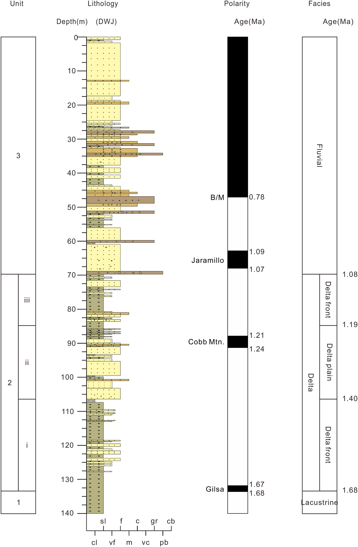
The chronological framework of the DWJ core is based on the magnetostratigraphy of Pan et al. (Reference Pan, Chen, Hu, Cao, Chen and Mao2016) (Fig. 2). The ages of the samples were estimated by linear interpolation, assuming a uniform sedimentation rate within a given polarity chron, although there are unquantified uncertainties associated with the assumption of constant sedimentation rates for sediments between polarity transitions and concerns about possible hiatuses. The existence of any long-term gaps in sedimentation are unlikely, because (1) the drilling site is located in the depocenter of the Jiudong basin during the Quaternary (Liu et al., Reference Liu, Fang, Song, Dai, Zhang, Zhang, Miao, Liu and Wang2010a; Pan et al., Reference Pan, Chen, Hu, Cao, Chen and Mao2016) and is experiencing sediment deposition at the present time; and (2) the magnetic polarity sequence of the DWJ core matches well with the Geomagnetic Polarity Time Scale (Gradstein et al., Reference Gradstein, Ogg and Smith2004) and records a continuous magnetic polarity sequence from C1r.3n to C1n (Pan et al., Reference Pan, Chen, Hu, Cao, Chen and Mao2016). Furthermore, the sedimentation rate for the upper 69.7 m of the drilled strata, which are composed dominantly of fluvial sediments (i.e., since the Jaramillo subchron), shows no big changes and is stable at ~60 mm/ka (Pan et al., Reference Pan, Chen, Hu, Cao, Chen and Mao2016). We therefore assume that unknown hiatuses and variable sedimentation rates do not significantly influence our interpretation of the long-term trends of climate change.
MATERIALS AND METHODS
Sampling
Ninety-six samples were taken for clay mineral analyses at intervals of 1–3 m. Most of the clay mineral samples were collected at a constant interval of ~1 m, while a few samples were collected at intervals of 2–3 m depending on the availability of suitable sediments. In some intervals, unconsolidated sediments could not be sampled, because they were not retained within the core barrel during drilling; in addition, the gravel layers in the upper part of the core were unsuitable for clay mineralogical study, and therefore no samples were collected.
XRD analysis
About 30–50 g of sediment was treated with 250 ml of deionized water for 24 h at room temperature. After the supernatant was siphoned off, the sample was boiled in a water bath with 30% H2O2 at a constant temperature of 80°C for 72 h to remove any organic material. The samples were then treated for 24 h with 10% HCl to remove carbonate coatings on detrital grains, and then thoroughly cleaned with deionized water until no flocculent muddy deposit was left. The samples were then dispersed with 0.5 g of Na(PO3)6 and an ultrasonic vibrator before extraction of clay minerals by settling in a 1000 ml glass tube, following Stokes's law (Stokes, Reference Stokes1845). Routine XRD analysis of the clay particles was carried out for each sample, including the sequential collection of three XRD patterns under air-drying conditions (N), after saturation with ethylene glycol (EG) in a desiccator (55°C for 9 h), and after heating in a muffle furnace at 550°C for 2 h (H) (Fig. 3). Following treatment, the XRD diagrams were obtained by XRD with CuKα radiation and a Ni filter using a PANalytical X'Pert Pro MPD diffractometer at a voltage of 40 kV and an intensity of 40 mÅ. Diffraction patterns (2θ) were scanned from 3° to 30°, with a step size of 0.016711°. The measurements were conducted in the Key Laboratory of Western China's Environmental Systems (Ministry of Education of China), Lanzhou University.

Figure 3. (color online) X-ray diffraction patterns of clay samples from drill core DWJ. (a) Sample DWJ1100 from a depth of 1.1 m; (b) sample DWJ4000 from a depth of 40 m; (c) sample DWJ11700 from a depth of 117 m; (d) sample DWJ13900 from a depth of 139 m. N, natural condition; E, ethylene glycol saturation; H, 550°C heating.
Qualitative analysis of clay minerals was based on characteristic reflections in three differently treated XRD patterns (Fig. 3). Specifically, the characteristic peak of smectite was measured at 17 Å in the EG-treated samples and then collapsed to 10 Å after being heated to 550°C. The characteristic peaks of chlorite are 14.1, 7, 4.8, and 3.53 Å, and they did not change after EG saturation. The intensity of the peak at 7, 4.8, and 3.53 Å collapsed, whereas the 14.1 Å peak for chlorite was enhanced after heating to 550°C. Illite was determined by peaks at 10, 5, and 3.33 Å, and their positions did not change after saturation. The 10 Å peak was intensified after heating to 550°C due to the collapse of smectite layers. Kaolinite was identified by the 7 and 3.58 Å peaks, which disappeared after heating to 550°C.
Semiquantitative estimates of clay mineral contents were made based on Liu et al. (Reference Liu, Colin, Li, Zhao, Tuo, Chen and Siringan2010b). Semiquantitative estimates of the peak areas of the basal reflections for the main clay mineral groups of smectite (17 Å), illite (10 Å), and kaolinite/chlorite (7 Å) were obtained from the EG-treated curves (Fig. 3) using the MacDiff software application (Petschick, Reference Petschick2000). The relative proportions of kaolinite and chlorite were determined based on the ratio of the 3.58/3.53 Å peak areas. Illite crystallinity was obtained from the half-height width of the 10 Å peak in the EG-treated curves, and the chemical index (CI) of illite was obtained from the 5/10 Å peak-intensity ratio in the EG patterns.
SEM analysis
Based on the results of the XRD analysis of the clay mineral assemblages of the sediments, five representative samples were selected for SEM observation using selected platinum-coated block samples. The observations were made using a TESCAN MIRA3 scanning electron microscope with an accelerating voltage of 20 kV and a beam current of 1–3 nÅ. SEM was carried out at the Key Laboratory of Magnetism and Magnetic Material (Ministry of Education of China), Lanzhou University.
RESULTS
SEM results
The clay particles in the studied samples typically occurred as discrete particles with angular and irregular outlines, and aggregates of clay particles usually exhibited a typical swirly texture indicating a detrital origin (Manju et al. Reference Manju, Narayanan Nair and Lalithambika2001; Hong et al., Reference Hong, Zhang and Li2010) (Fig. 4). Authigenic/pedogenic smectite typically has a honeycomb structure that coats the clasts, while authigenic kaolinite typically has a booklet structure (Huyghe et al., Reference Huyghe, Guilbaud, Bernet, Galy and Gajurel2011; Song et al., Reference Song, Zhang, Zhang, Ji, Hong, Wei, Xu, Algeo and Wang2018). These characteristics were not observed in the sediments.

Figure 4. Scanning electron microscopy (SEM) images of samples from the DWJ core.
XRD results
The semiquantitative analyses of the XRD diagrams suggest that the clay minerals from the DWJ core are dominated by illite (Ill), followed by chlorite (Chl), smectite (Sme), and kaolinite (Kln) (Fig. 5). Mixed-layer illite-smectite is absent in the sediments. The non-clay minerals feldspar and clastic quartz are present in the XRD diagrams in small amounts, but they were not quantified (Fig. 3). Individual minerals exhibit significant fluctuations in content (Fig. 5): illite ranges from 13% to 66% (mean 44.5%); chlorite from 4% to 41% (mean 19.9%); smectite from 1% to 66% (mean 19.1%); and kaolinite from 5% to 49% (mean 16.4%). The crystallinity of illite (KI) ranges from 0.13∆°/2θ to 0.50∆°/2θ with a mean of 0.25∆°/2θ (Fig. 5). The illite was well crystallized, indicating that the clay minerals have undergone relatively weak postdepositional weathering (Ehrmann, Reference Ehrmann1998). The chemical index of illite (CI) ranges from 0.12 to 0.58 with a mean of 0.26 (Fig. 5). The low CI values observed in the sediments are attributed to the occurrence of weak chemical degradation processes (Zeng et al., Reference Zeng, Song, An, Chang and Li2014).

Figure 5. (color online) Variation of clay mineral indices with depth in the DWJ core. Kln, Kaolinite, Ill, Illite, Chl, Chlorite, Sme, Smectite; CI, chemical index; KI, crystallinity of illite.
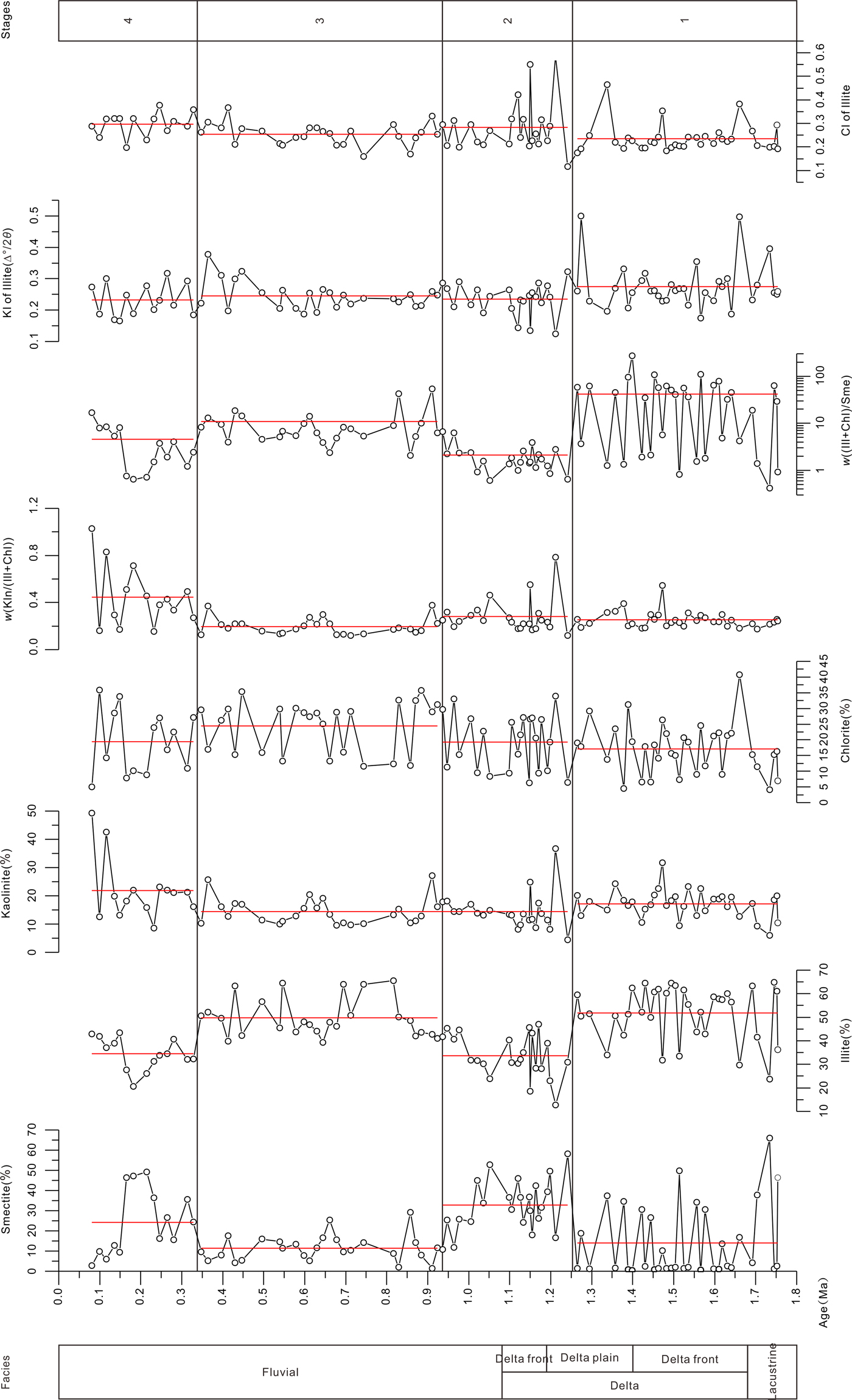
Four periods of clay mineral assemblages are recognized from core DWJ (Fig. 6; Table 2):
Stage 1 (139.9–92.4 m, ~1.8–1.2 Ma): In this period, illite has a mean content of 52%, followed by chlorite with a mean content of 17%. The contents of kaolinite (mean 17%) and smectite (mean 14%) are relatively low, and these minerals record their second-lowest and third-lowest values, respectively. The w[Kln/(Ill + Chl)] (w, weight) attains its second-lowest mean value. By contrast, the w[(Ill + Chl)/Sme] reached the highest mean value. Illite has the lowest value of CI (mean 0.24), but the highest value of KI (mean 0.28∆°/2θ).
Figure 6. (color online) Evolutionary stages as indicated by the clay mineral along the DWJ core. Red lines represent mean values of clay mineral indices in each stage. CI, chemical index; KI, crystallinity of illite.
Table 2. Clay mineral indices and paleoenvironmental evolution stages in the DWJ core. σ = standard deviation; Chl, chlorite; CI, chemical index; Ill, illite; KI, crystallinity of illite; Kln, kaolinite; Smc, smectite.
Stage 2 (92.5–59.0 m, ~1.2–0.9 Ma): Illite has the lowest mean content of 34%, and by contrast, the mean content of smectite reaches its highest value of 33%. The mean content of chlorite increases slightly from 17% to 19%, while the percentage of kaolinite decreases slightly from 17% to 14%. The w[Kln/(Ill + Chl)] increases to 0.28, and by contrast the w[(Ill + Chl)/Sme] decreases to its minimum value of 2.11. The KI of illite decreases to its lowest mean value of 0.23∆°/2θ, and the CI of illite increases to its second-highest mean value of 0.28.
Stage 3 (59.0–20.5 m, ~0.9–0.3 Ma): The content of illite increases to its second-highest mean value of 50%, and that of chlorite increases to its highest mean value of 24%. The content of smectite reaches its second-lowest mean value, decreasing sharply from 33% to 11%; and the content of kaolinite increases slightly to 14%. The w[Kln/(Ill + Chl)] decreases to the minimum value of 0.2, while the w[(Ill + Chl)/Sme] reaches its second-highest value of 10.8. The KI of illite increases from 0.23 to 0.25∆°/2θ, and the CI of illite decreases from 0.28 to 0.25.
Stage 4 (20.5–4.9 m, ~0.3–0.1 Ma): In this stage, the percentages of illite (mean 35%) and chlorite (mean 19%) declined. By contrast, the percentages of smectite (mean 24%) and kaolinite (mean 22%) increased. The w[Kln/(Ill + Chl)] has the highest mean value of 0.44, whereas the w[(Ill + Chl)/Sme] decreases to its second-lowest value of 4.55. The KI of illite decreases to its minimum value of 0.23∆°/2θ, and the CI of illite reaches its highest value of 0.30.


DISCUSSION
The clay minerals were of illite–chlorite–kaolinite–smectite composition in the DWJ core, with individual minerals exhibiting strong fluctuations. The DWJ core was dominated by illite and chlorite, together comprising more than 64%, while kaolinite and smectite together accounted for only approximately 36% of the clay mineral content (Table 2). Four periods in long-term variation were identified based on the clay mineral records of the DWJ core.
Diagenetic and pedogenic influences
Notably, the changes in clay mineral assemblages are not correlated with changes in lithology and transitions of sedimentary facies (Figs. 5 and 6), indicating that changes in lithology and sedimentary facies appear to have no significant impact on the clay mineral assemblages. Given that early diagenesis (especially pedogenesis) and changes in detrital composition, are the major complicating factors for the interpretation of clay mineral assemblages in terms of climatic changes (Weaver, Reference Weaver1989; Ruffell et al., Reference Ruffell, McKinley and Worden2002), it is necessary to consider whether the clay mineral assemblages are of detrital or diagenetic origin before using them for paleoenvironmental reconstruction.
During diagenesis, smectite can be transformed to illite, with mixed-layer illite–smectite as an intermediate phase (Perry and Hower, Reference Perry and Hower1970). However, no mixed-layer illite–smectite was found in the DWJ core. The sediments contain discrete mineral grains that are predominantly of detrital origin, largely reflecting the characteristics of the parent rocks (Lindgreen and Surlyk, Reference Lindgreen and Surlyk2000). In addition, as shown in Figure 4, the swirly texture of the clay grains and the discrete poorly crystallized clastic clays with angular and irregular outlines are indicative of a detrital origin (Manju et al., Reference Manju, Narayanan Nair and Lalithambika2001). No evidence for the role of diagenesis in the production of the clay minerals was found in the sediments.
In addition, under the influence of diagenesis, the contents of smectite and kaolinite would be expected to exhibit a trend of persistent downward-decreasing values, and the contents of illite and chlorite would exhibit a trend of persistent downward-increasing values (Merriman and Roberts, Reference Merriman and Roberts2001; Drits et al., Reference Drits, Sakharov, Dainyak, Salyn and Lindgren2002). However, the clay mineral contents of core DWJ do not exhibit these trends (Fig. 5), which indicates that diagenesis has had little influence on the clay mineral assemblages, which is in accordance with their poorly cemented structure (Pan et al., Reference Pan, Chen, Hu, Cao, Chen and Mao2016).
Moreover, previous research indicates that the diagenetic illitization of smectite requires a burial depth of more than 1500 m (Chamley, Reference Chamley1989), a transition pressure of 900–920 kg/cm2, and a transition temperature of 100°C–140°C (Liu, Reference Liu1985), which suggests that the smectite in core DWJ has experienced very limited diagenetic illitization. The chemical characteristics of the local groundwater indicate that the study area is in a weakly alkaline environment with an average pH of 7.7, which implies a limited impact of chemical weathering processes on the clay minerals (Zhu et al., Reference Zhu, Su and Feng2008). The presence and preservation of abundant less resistant/unstable heavy minerals (e.g., amphiboles, epidotes) in core DWJ further indicates that postdepositional chemical weathering was negligible (Zhang et al., Reference Zhang, Li, Guo, Ma, Li, Ye and Yu2016b).
The absence of a typical honeycomb structure coating the clasts and a typical booklet structure in the sediments indicates the absence of authigenic/pedogenic smectite and kaolinite in core DWJ (Huyghe et al., Reference Huyghe, Guilbaud, Bernet, Galy and Gajurel2011; Song et al., Reference Song, Zhang, Zhang, Ji, Hong, Wei, Xu, Algeo and Wang2018). Given that the sediments were mainly deposited subaqueously (except for the fluvial floodplain facies), we would not expect to find pedogenic alteration of clay minerals, which can only occur subaerially (Huyghe et al., Reference Huyghe, Guilbaud, Bernet, Galy and Gajurel2011). Moreover, if pedogenic alteration of detrital minerals was the primary source of the smectite and kaolinite, the abundance of smectite and kaolinite would be expected to vary synchronously with changes in lithology (Fang et al., Reference Fang, Hong, Zhao, Furnes, Lu, Han and Liu2017). However, as mentioned earlier, this is not the case in core DWJ (Fig. 5 and 6). In summary, based on the SEM observations and the smectite/kaolinite concentration profile (Fig. 4–6), we infer that the contribution of in situ pedogenic minerals is minor and that the clay minerals in core DWJ are of detrital origin.
Provenance of the clay minerals
The sediments from core DWJ comprise lacustrine and fluvial facies (Pan et al., Reference Pan, Chen, Hu, Cao, Chen and Mao2016). Weathering products from the central regions of the North Qilian Shan (the catchment of the Heihe drainage system), drained by the Heihe River and its tributaries, are possible source areas (Pan et al., Reference Pan, Chen, Hu, Cao, Chen and Mao2016). This inference is supported by a comparison of the results of heavy mineral analyses of sediments from the core with those from the modern Heihe drainage system (Zhang et al., Reference Zhang, Hu, Geng, Chen and Pan2016a), which show that the heavy mineral characteristics in the lower part of the DWJ core (140–69.7 m) are different from those in the trunk Heihe River, but the heavy mineral characteristics in the upper part of the DWJ core (69.7–0 m) are similar to those in the trunk Heihe River. Windblown loess may have some influence on the composition of the sediments in the core, but its contribution is believed to be minor. Specifically, the following observations suggest that the influence of windblown loess on our results can be excluded: (1) the oldest loess accumulation in the Jiudong subbasin commenced at ~104.0 ± 10.1 ka based on optically stimulated luminescence dating (Hu et al., Reference Hu, Pan, Fan, Wang, Hu, Cao, Li and Geng2017; Zhang et al., Reference Zhang, Nottebaum, Tsukamoto, Lehmkuhl and Frechen2015), which is more recent than the upper age limit of the sediments considered herein. (2) The combination of low temperatures and high wind speeds prevented the development of vegetation and resulted in dust bypassing the Qilian Shan through the Hexi Corridor (Küster et al., Reference Küster, Hetzel, Krbetschek and Tao2006). Considering that the river may transport sediments from various sources along its course (Reading, Reference Reanding1996), we conclude that the clay mineral assemblages in core DWJ can potentially be used to provide paleoclimatic information about the source area in the central regions of the North Qilian Shan and the Zhangye–Jiudong subbasin.
Paleoclimatic changes based on clay mineral assemblages
Illite is an indicator of mechanical erosion together with the relatively limited production of chemically weathered material from the alteration of aluminosilicate minerals under a dry and cool climate (Grim, Reference Grim1968; Millot, Reference Millot1970; Weaver, Reference Weaver1989). Chlorite is the direct product of the physical weathering of parent rocks, such as metamorphic rocks and greenschist facies, which have undergone weak chemical weathering under a cold and dry climate (Robert and Kennett, Reference Robert and Kennett1994). Illite and chlorite are typically recognized as early products of the physical weathering of parent rocks under a cold and dry climate (Biscaye, Reference Biscaye1965).
Smectite and kaolinite are formed during the advanced stages of chemical weathering (Chamley, Reference Chamley1989; Weaver, Reference Weaver1989; Liu et al., Reference Liu, Colin, Trentesaux, Siani, Frank, Blamart and Farid2005). Smectite is generally considered to form during the weathering of biotite, plagioclase, and volcanic materials in seasonally wet and dry climates with a low water:rock ratio (Weaver, Reference Weaver1989; Cuadros et al., Reference Cuadros, Caballero, Huertas, De Cisneros, Huertas and Linares1999; Fürsich et al., Reference Fürsich, Singh, Joachimski, Krumm, Schlirf and Schlirf2005). These conditions generally correspond to intermittently poorly drained environments, including in areas with a monsoonal climate characterized by strongly seasonal precipitation. Kaolinite is the product of the chemical weathering of acidic igneous and metamorphic rocks under warm and wet conditions. The occurrence of kaolinite indicates a source region that has experienced intense weathering (Biscaye, Reference Biscaye1965; Hallam et al., Reference Hallam, Grose and Ruffell1991).
Clay mineral ratios, such as w[Kln/(Ill + Chl)] and w[(Ill + Chl)/Sme], are frequently used to reconstruct processes of chemical weathering and hence changes in climatic conditions (Liu et al., Reference Liu, Colin, Huang, Le, Tong, Chen and Trentesaux2007; Wang et al., Reference Wang, Hong, Xiang, Zhang and Xiao2008). A decrease in w[Kln/ (Ill + Chl)] and an increase in w[(Ill + Chl)/Sme] suggest a shift to a relatively cool and dry climate (Chamley, Reference Chamley1989; Wang et al., Reference Wang, Hong, Xiang, Zhang and Xiao2008). Within core DWJ, the values of w[Kln/(Ill + Chl)] fluctuate between 0.20 and 0.44, with a mean of 0.27; and the values of w[Kln/(Ill + Chl)] fluctuate between 2.11 and 41.4, with a mean of 18.8 (Fig. 5; Table 2).
Four periods of different paleoclimatic conditions are recognized from the clay mineral assemblages of core DWJ (Fig. 6; Table 2) based on the relative abundance of different clay minerals. They are:
Stage 1 (139.9–92.4 m, ~1.8–1.2 Ma): The clay mineral assemblages and ratios, together with the CI, suggest a relatively dry and cool climate.
Stage 2 (92.5–59.0 m, ~1.2–0.9 Ma): Characteristics of clay mineral assemblages indicate a change of climate from the relatively dry and cool climate of stage 1 to a wetter and warmer climate with strongly seasonal precipitation.
Stage 3 (59.0–20.5 m, ~0.9–0.3 Ma): The clay mineral assemblages and ratios and the CI of illite are indicative of physical weathering processes in a cooling climate with intensifying aridification.
Stage 4 (20.5–4.9 m, ~0.3–0.1 Ma): In this stage, the increase in the contents of smectite and kaolinite and in the w[Kln/(Ill + Chl)] and CI can be attributed to the effects of intensified chemical weathering in a relatively warm and wet climate with strongly seasonal precipitation.
The variations in the clay mineral indices suggest that the climate of the Jiudong subbasin was relatively cool and dry after ~1.8 Ma; warmer and wetter with strongly seasonal precipitation during ~1.3–0.9 Ma; and relatively cold and dry during ~0.3–0.1 Ma.
Correlation with other paleoenvironmental records
We compared our paleoclimatic record of the DWJ drill core with independent paleoclimatic records from the westerlies-dominated region, the zone of intersection of the westerlies, and the EASM and the EASM-dominated region (Fig. 7).

Figure 7. (color online) Comparison of clay mineral records (a–c) and stages of paleoclimatic evolution (d) derived from drill core DWJ with eolian sand proportions and the chemical index of alteration (CIA) of core WEDP01 from the Tengger Desert (e, f) (Li et al., Reference Li, Wang, Wang, Li and Chen2018); EASM rainfall index (g) (Sun et al., Reference Sun, An, Clemens, Bloemendal and Vandenberghe2010); magnetic susceptibility record of the CLP (h) (Song et al., Reference Song, Fang, King, Li, Naoto and An2014); pollen data and vegetation form from core SG-3 core from the western Qaidam basin (Cai et al., Reference Cai, Fang, Wu, Miao and Appel2012) (i, j) CLP, Chinese Loess Plateau.
During ~1.8–1.2 Ma, the values for CI, w[Kln/(Ill + Chl)], and w[(Ill + Chl)/Sme] in core DWJ indicate that the climate was relatively dry. A sedimentary record from core WEDP01 from the Tengger Desert, located in the intersection of the westerlies and the EASM (Wang et al., Reference Wang, Chen, Huang and Zeng2017; Chen et al., Reference Chen, Huang, Jin, Chen, Chen and Chen2018), supports this interpretation and suggests a strengthening of aridity at 1.8 Ma, evidenced by a marked decrease in the CIA (chemical index of alteration) (Fig. 7) (Li et al., Reference Li, Wang, Wang, Li and Chen2018). Variations in the eolian sand component of core WEDP01, which is a sensitive proxy of aridification, suggest a phased increase of aridity in the Tengger Desert during the period 1.8–1.25 Ma (Li et al., Reference Li, Wang, Wang, Li and Chen2018).
Notably, the results from the zone of intersection of the westerlies and the EASM are contrary to records from the westerlies-dominated region but are in accord with those from the EASM region. A short interval of relatively cold and moist conditions was identified from ~1.8 to ~1.2 Ma by an increase in A/C ratio (the ratio of the percentages of Artemisia to Chenopodiaceae), indicating a change to a steppe environment (Fig. 7) (Cai et al., Reference Cai, Fang, Wu, Miao and Appel2012). In addition, the loess of the Chinese Loess Plateau (CLP) accumulated at a faster rate (Sun and An, Reference Sun and An2005), was coarser grained (Sun et al., Reference Sun, Su, Bloemendal and Lu2008), and had lower values of CIA (Xiong et al., Reference Xiong, Ding, Zhu, Zhou and Lu2010) during the same interval, indicating cooler and drier conditions. The decrease in summer monsoon (precipitation) index during 1.8–1.25 Ma recorded in the Lingtai section in the center of the CLP indicates a weakening of the EASM (Sun et al., Reference Sun, An, Clemens, Bloemendal and Vandenberghe2010). Moreover, a recent quantitative climatic reconstruction of EASM rainfall from the CLP based on carbonate dissolution suggests that the rainfall on the CLP was lower during the early Pleistocene (Meng et al., Reference Meng, Liu, Wang, Balsam, Chen and Ji2018).
During the period between ~1.2 and 0.9 Ma, a relatively warm and humid climate occurred in the Jiudong subbasin, as indicated by the high values of CI and w[Kln/(Ill + Chl)] ratios. The higher abundance of smectite suggests that the climate had a significant seasonality with strongly seasonal precipitation (Weaver, Reference Weaver1989; Cuadros et al., Reference Cuadros, Caballero, Huertas, De Cisneros, Huertas and Linares1999; Fürsich et al., Reference Fürsich, Singh, Joachimski, Krumm, Schlirf and Schlirf2005). This relatively humid climate during the interval of 1.2–0.9 Ma was also recorded in the Tengger Desert. The eolian sand component of core WEDP01 decreased significantly, accompanied by higher values of CIA, indicating that a humid climate existed in the Tengger Desert (Li et al., Reference Li, Wang, Wang, Li and Chen2018) (Fig. 7). The records from the zone of intersection of the westerlies and EASM differ from those in the westerlies-dominated region, but they are similar to records from the EASM region. The period from 1.2 to 0.9 Ma was marked by drier conditions in the western Qaidam basin, indicated by the decreasing trend of A/C ratios (Cai et al., Reference Cai, Fang, Wu, Miao and Appel2012). The intensification of the EASM during 1.25–0.9 Ma is indicated by abrupt increases in the free Fe2O3/total Fe2O3 ratio (Yang and Ding, Reference Yang and Ding2001), magnetic susceptibility, and EASM index (precipitation) (Fig. 7) (Sun et al., Reference Sun, An, Clemens, Bloemendal and Vandenberghe2010; Song et al., Reference Song, Fang, King, Li, Naoto and An2014; Zhang et al., Reference Zhang, Li, Guo, Ma, Li, Ye and Yu2016b). Moreover, EASM rainfall reconstructions from the CLP suggest high rainfall on the CLP during 1.25–0.85 Ma (Meng et al., Reference Meng, Liu, Wang, Balsam, Chen and Ji2018).
From ~0.9 to 0.3 Ma, the low values of CI and w[Kln/(Ill + Chl)] and high values of w[Kln/(Ill + Chl)] indicate that the climate was drier. This drying event was also identified in other records in the area of intersection of the westerlies and the EASM, as well as in the EASM region. Grain-size components of core WEDP01, together with lower values of CIA, indicate enhanced aridity at 0.9 Ma (Fig. 7). This mid-Pleistocene aridity event within the area of intersection of the westerlies and the EASM was also recorded in the western Qaidam basin (Cai et al., Reference Cai, Fang, Wu, Miao and Appel2012) and in the CLP (An et al., Reference An, Huang, Liu, Guo, Colman, Li and Warren2005). From 0.9 to 0.3 Ma, the climate became much drier, as indicated by a decrease in A/C ratios (Cai et al., Reference Cai, Fang, Wu, Miao and Appel2012). Decreases in CIA in the Luochuan and Baishui sections at ~0.9 Ma suggest the enhanced aridification of the EASM-dominated region (Chen et al., Reference Chen, An, Liu, Ji, Yang and Chen2001; Xiong et al., Reference Xiong, Ding, Zhu, Zhou and Lu2010); and the carbon isotope record of the Lingtai loess section indicates an expansion of C4 plants at the same time (An et al., Reference An, Huang, Liu, Guo, Colman, Li and Warren2005). The decrease in summer monsoon (precipitation) index in the Lingtai loess section at the same time also indicates the weakening of the Asian monsoon (Sun et al., Reference Sun, An, Clemens, Bloemendal and Vandenberghe2010).
During ~0.3–0.1 Ma, a relatively warm and humid climate in the Jiudong subbasin is indicated is indicated by high values of CI and the w[Kln/(Ill + Chl)] ratio. The higher abundance of smectite indicates that the climate had a pronounced seasonality, with strongly seasonal precipitation. Relatively moist conditions are inferred in the Tengger Desert: during 0.34–0.15 Ma, where there was a decrease in the eolian sand components of core WEDP01 core, together with higher values of CIA, suggesting the occurrence of a relatively humid climate in the zone of intersection of the westerlies and the EASM (Li et al., Reference Li, Wang, Wang, Li and Chen2018) (Fig. 7). Notably, the records from the area of intersection of the westerlies and the EASM are different from those from the westerlies-dominated region, but they are synchronous with the enhancement of the EASM. From 0.35 Ma, the climate in the western Qaidam basin became extremely dry, as indicated by a minimum value for the A/C ratio (Fig. 7) (Cai et al., Reference Cai, Fang, Wu, Miao and Appel2012). Pollen assemblages imply increased precipitation after 0.34 Ma in the middle-lower reaches of the Yangtze River, and thus an intensification of the EASM (Qi et al., Reference Qi, Qiao, Li, Wang, Peng, He, Yang, Han and Zhang2017). In the Shimao sand–loess–paleosol sequence, a marked increase in magnetic susceptibility since ~0.34 Ma indicates an enhancement of the summer monsoon and is synchronous with the initial of the formation of paleosol S3) (Sun et al., Reference Sun, Ding and Liu1995). This increase is also located in the desert–loess transitional zone belt between the Mu Us Desert and the CLP; in the Baoji loess section (Liu et al., Reference Liu, Ding, Yu and Rutter1993) on the southern edge of the CLP; in the Lanzhou loess section (Zhang et al., Reference Zhang, Li, Guo, Ma, Li, Ye and Yu2016b) on the western edge of the CLP; and in the Lingtai, Chaona loess section (Sun et al., Reference Sun, An, Clemens, Bloemendal and Vandenberghe2010) in the central CLP. An increase in the summer monsoon (precipitation) index is also recorded in the Lingtai section at the same time (Fig. 7) (Sun et al., Reference Sun, An, Clemens, Bloemendal and Vandenberghe2010).
It is evident from the foregoing that the paleoclimatic record of core DWJ since ~1.8 Ma is consistent with other records from the zone of intersection of the westerlies and the EASM. Comparison of the climatic records from this intersection zone with the paleoclimatic records from the westerlies-dominated and EASM-dominated regions reveals that they match well with the stages in the evolution of the EASM; however, they are not in agreement with records from the westerlies-dominated region, except during the interval of ~0.9–0.3 Ma (Fig. 7). Therefore, it is possible to conclude that the paleoclimatic record of the Jiudong subbasin is related to the long-term evolution of the EASM, especially the two relatively wet intervals with increased seasonal precipitation during 1.2–0.9 and 0.3–0.1 Ma. We propose that during these intervals, the strengthened EASM caused a substantial increase in seasonal precipitation in the central region of the North Qilian Shan and Tengger Desert. Therefore, the results of this study suggest that the EASM was able to penetrate into the central region of the North Qilian Shan during 1.2–0.9 and 0.3–0.1 Ma. Notably, during ~0.9–0.3 Ma, dry climatic conditions were recorded throughout the westerlies-dominated region, in the zone of the intersection of the westerlies and the EASM, and in the EASM-dominated region. This may have been the result of the uplift of the Tibetan Plateau, which was significantly enhanced after 0.9 Ma, when the plateau surface entered the cryosphere (Fang et al., Reference Fang, Zhao, Li, Yan, Pan, Song and Dai2005; Li et al., Reference Li, Fang, Song, Pan, Ma and Yan2014). This event led to the splitting and bending of the westerlies airflow, a reduction in the moisture supply to East Asia (Han et al., Reference Han, Fang, Ye, Teng and Zhang2014), and an intensification of the Siberian high (Ruddiman and Kutzbach, Reference Ruddiman and Kutzbach1989). The drying of Asia during ~0.9–0.3 Ma may also have been driven by a significant expansion of continental ice sheets at ~0.9 Ma (Ruddiman and Kutzbach, Reference Ruddiman and Kutzbach1989; Snyder, Reference Snyder2016), although the climatic mechanisms are complex and need further elucidation.
CONCLUSIONS
The clay minerals in drill core DWJ from the Jiudong subbasin are dominantly detrital in origin and reflect climatic conditions in the source areas. The variations in clay mineral content and related ratios indicate that a relatively cold and arid climate prevailed in the central region of the North Qilian Shan and the Zhangye–Jiudong subbasin since ~1.8 Ma. The paleoclimatic evolution of the central region of the North Qilian Shan and the Zhangye–Jiudong subbasin since ~1.8 Ma can be divided into four stages: During stage 1 (1.8–1.2 Ma), the climate was relatively cold and arid; during stage 2 (1.2–0.9 Ma), it was relatively warm and humid, with strongly seasonal precipitation; during stage 3 (0.9–0.3 Ma), it was colder and drier than during the preceding stage; and during stage 4 (0.3–0.1 Ma), it was relatively warm and humid, with strongly seasonal precipitation. Analysis of clay mineral indices and comparisons with regional paleoclimatic records from elsewhere suggest that the climatic conditions during stages II and IV were the result of the enhancement of the EASM.
ACKNOWLEDGMENTS
We are grateful to Yaoyang Lu, Xilin Cao, Yunxia Jia, Lianyong Guo, and Ying Chen for their hard work in the field and in the laboratory. Thoughtful feedback from the senior editor, associate editor, and two reviewers improved the presentation of the scientific results in the article. We thank Jan Bloemendal for language editing. This research is financially supported by the National Natural Science Foundation of China (NSFC grant nos. 41730637, 41571003, and 41471009) and the Key Project of the Major Research Plan of the NSFC (grant no. 91125008).