


Introduction
Evidence for Neolithic salt production in Britain is elusive. The earliest known European sites with such Neolithic evidence have been found in the Balkans, western France and Germany (Weller & Dumitroaia Reference Weller and Dumitroaia2005; Ard & Weller Reference Ard, Weller and Joussaume2012; Harding Reference Harding2017: 43–52). In Britain at this time (c. 4000 BC) subsistence practice was characterised by a change from hunting and gathering to sedentism, and the domestication of plants and animals. Coastal dwellers became increasingly dependent upon a terrestrial diet (Cramp et al. Reference Cramp, Jones, Sheridan, Smyth, Whelton, Mulville, Sharples and Evershed2014). This article presents evidence from north-east England of a Neolithic saltern—defined here as a designated area or installation for the production of salt—and a brine-storage tank, dating to 3800–3700 BC. A summary of the archaeological stratigraphy is supported by selected finds and a suite of radiocarbon dates, and is discussed in the context of contemporaneous European parallels. These findings from Street House begin to fill the current lacuna in evidence for the production of salt in Neolithic Britain, and are significant for our understanding of Neolithic diet, methods of food preservation and animal husbandry, as well as wider questions of distribution and value in British Neolithic society.
Background
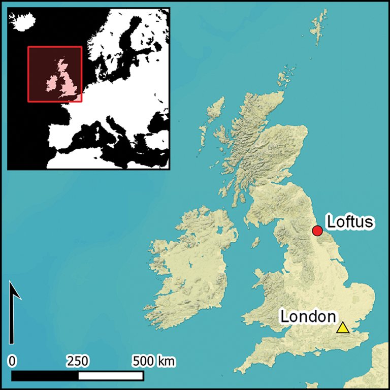
In the 1980s, two Neolithic sites were excavated at Street House: an Early Neolithic cairn and associated mortuary structure (Vyner Reference Vyner1984), and a Late Neolithic palisaded monument, which the excavator termed the “Wossit” (Vyner Reference Vyner1988) (Figure 1). Together, the sites suggested the potential for the identification of further Neolithic, as well as Mesolithic, activity in this part of North Yorkshire, somewhat geographically distant from known concentrations of Neolithic sites in the county around Rudston in East Yorkshire and Thornborough in North Yorkshire (Manby et al. Reference Manby, King, Vyner, Manby, Moorhouse and Ottaway2003: 73; Harding Reference Harding2013). Griffiths (Reference Griffiths2011: 320) reviewed the dates for the Street House Neolithic cairn as part of a programme of chronological modelling of the Mesolithic–Neolithic transition in the Midlands and the north of England, suggesting that the cairn was in use c. 3730–3650 cal BC (at 95.4% probability, or 3710–3660 cal BC at 68.2%).
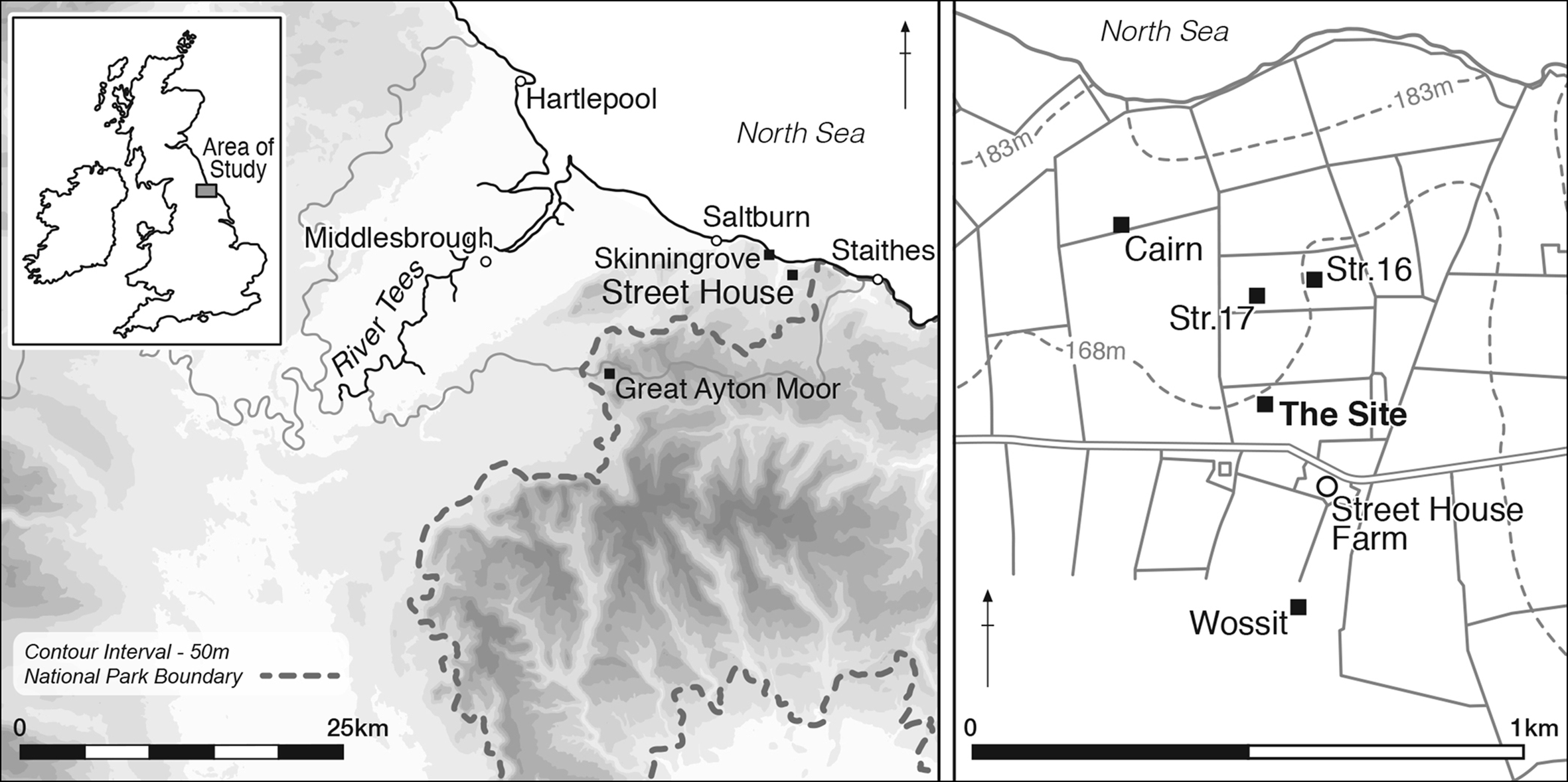
Figure 1. Location of Street House Farm in North Yorkshire and the nearby Neolithic sites (redrawn by L.M. Jones).
The current programme of fieldwork at Street House began in 2004, with investigations of a developed Iron Age settlement dating to c. 200–1 BC and an Anglo-Saxon cemetery dating to c. AD 630–670 (Sherlock Reference Sherlock2012a & Reference Sherlockb), both located 200m to the east of Vyner's Early Neolithic cairn. The Iron Age settlement yielded significant evidence for salt production, continuing into the Roman period (Sherlock & Vyner Reference Sherlock and Vyner2013). The Iron Age saltern was located at 170m asl. Although only 300m from the coast, there is no direct access to the foreshore from this cliff-top site, suggesting a journey of at least 4km to the nearest beach at Skinningrove (Figure 1). While it may be possible to reduce seawater to a concentrated brine on the foreshore, the time between tides may prove problematic. Experimental reconstruction of this stage calculated a period of 4 hours to pre-boil brine and a further 2.5 hours to make salt cakes from the paste, during which time it was important to control the temperature (Tencariu et al. Reference Tencariu, Alexianu, Cotiugă, Vasilache and Sandu2015: 130). The distance between the beach and the Street House saltern may suggest that seawater was concentrated by evaporation into a brine solution in the shelter of the valley at Skinningrove, before being transported up to the site, where heating conditions could be controlled (Sherlock & Vyner Reference Sherlock and Vyner2013: 63). Other examples of Iron Age salterns similarly situated at cliff-top sites are found at Kimmeridge in Dorset (P. Cox, pers. comm.) and ‘Needle’ Eye enclosure at Berwick upon Tweed, Northumberland (Proctor Reference Proctor2012).
The most recent investigations at Street House have revealed further evidence for Neolithic settlement (Figure 1). This includes a segmented ring-ditch (structure 16, phase I) dated to the Early Neolithic by radiocarbon assay on a hazelnut shell (Corylus sp.) from the lower fill of the ditch's northern segment (SUERC-70581: 4912±33 BP, 3766–3647 cal BC at 95.4%; Sherlock Reference Sherlock2019: 17–20), and a double ring of postholes and an entrance porch marked by four further postholes (structure 17). Excavation at the current location commenced in 2016, and continued each summer to September 2019 (Figures 1–2).

Figure 2. The excavation at Street House showing the depth of the stratigraphy, September 2019 (photograph by S.J. Sherlock).
The Neolithic site
The Neolithic site was located by geophysical survey in 2011 (Lawton Reference Lawton and Sherlock2019: 15). It was identified as an anomaly with a high magnetic response, which was also recognised by resistivity survey. The site is located in a pasture field, the only known disturbance of which since the Romano-British period has been the insertion of a nineteenth-century field drain. Archaeological evaluation in 2014 demonstrated that the magnetic anomaly was a very deep, cut feature (Sherlock Reference Sherlock2019: 10, tab. 1.2).
The stratigraphic sequence
The excavation began by hand, guided by the experience of earlier work, and demonstrated that, 15m to the west, the boulder-clay horizon was covered by only 0.30m of topsoil. The geophysical survey targeted the site precisely, and the expectation was that the site would be found under this shallow topsoil, yet 0.55m of topsoil and subsoil was removed to expose a boulder-clay horizon (layer 1529). This 0.37m-thick layer of compacted clay with charcoal flecks was removed. Within layer 1529 was a 0.16m-thick charcoal deposit (layer 1532). A radiocarbon determination from a hazelnut shell (Corylus sp.) from within layer 1532 has yielded a date of 3977±30 BP (SUERC-68559: 2578–2455 cal BC at 95.4% probability; date modelled in OxCal v.4.2, using the IntCal13 calibration curve (Bronk Ramsey Reference Bronk Ramsey2009; Reimer et al. Reference Reimer2013); Table 1), dating this horizon (phase 4) to the Late Neolithic.
Table 1. Radiocarbon dates from the Street House excavations (radiocarbon age calibrated in OxCal 4.2–4.3 (Bronk Ramsey Reference Bronk Ramsey2009) using the IntCal13 atmospheric curve (Reimer et al. Reference Reimer2013)).
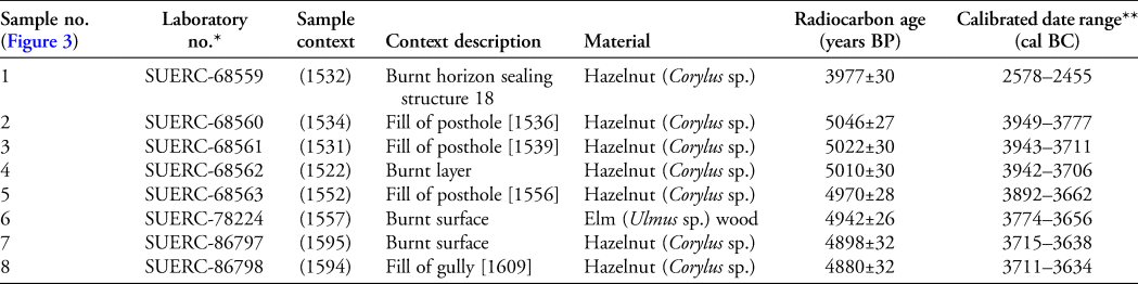
* Laboratory: SUERC, Scottish Universities Environmental Research Centre.
** Calibrated date range at 95.4% probability.
Layers 1529 and 1532 were removed to reveal an ovoid feature measuring 8m north–south and 5m east–west (maximum dimensions). Excavation of this feature revealed three distinct phases of Early Neolithic activity. Phase 3 comprised a house (structure 18) defined by an arc of five postholes at the northern end, further postholes to the south and a suite of associated domestic artefacts. The finds assemblage includes ceramic sherds primarily from carinated bowls, lithics including leaf-shaped arrowheads, blades, cores and flakes, a saddle quern and pounder, and other stone items. These artefact typologies coupled with the radiocarbon determinations confirm an Early Neolithic date (Sherlock Reference Sherlock2019: 16–17). Beneath phase 3, a burnt horizon (phase 2), interpreted as a saltern, has yielded six radiocarbon dates (Figure 3; Table 1). Phase-1 layers, beneath the saltern, have yet to be fully excavated.
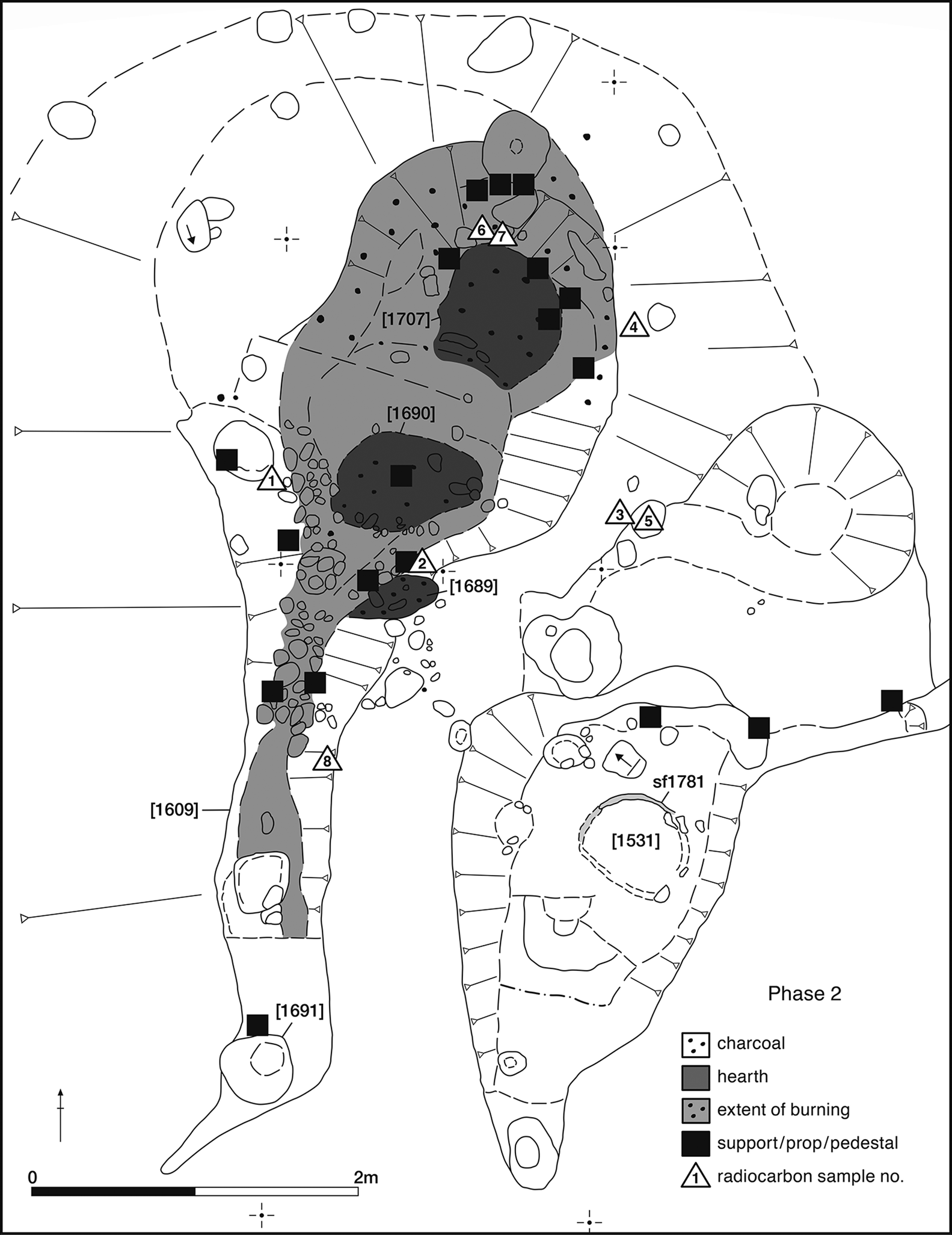
Figure 3. Plan of the site (phase 2), showing the main features and the location of supports/props/pedestals and selected radiocarbon samples (redrawn by L.M. Jones).
Structural evidence for a saltern
The burnt horizon, phase 2 in the stratigraphic sequence, is interpreted here as a saltern. The principal feature is a chamber measuring 2m east–west and 2.80m north–south, with a narrow 0.60–0.90m-wide × 0.90m-deep trench [1609] extending farther south, giving the entire complex a total length of 6.50m (Figures 3–4; numbers in square brackets indicate feature cut numbers). The chamber was defined on the west, north and east sides by burnt layers (1595 and 1598) containing oak (Quercus sp.) charcoal derived from burnt timbers (AoC Archaeology Group 2018–2019). Both of these layers yielded numerous flint tools and ceramic sherds. Within the chamber were three areas of intense burning, which I interpret to be locations of hearths [1689, 1690 & 1707]. Around the edge of each of these hearths was a concentration of fire-reddened, wedge-shaped stones and ceramic material, which I suggest to be props or supports for the oven furniture and ceramic vessels containing the brine (Figure 5), as documented at other salt-production sites (Lane & Morris Reference Lane and Morris2001; Morris Reference Morris, Haselgrove and Moore2007). The stones are of substantial size, carved into an L-shape and positioned to face into the interior of the structure. The shaping and placement of these stones reinforce their interpretation as possible supports for a saltern-type structure. At the southern end of the narrow trench [1609] was a posthole [1691] and stakeholes, suggesting a possible flue or chimney. Artefacts found in situ included stone prop sf1956 near posthole [1691], ceramic vessel sf3549 in the centre of trench [1609] and ceramic prop sf3285 in the northern arm or spur of the ‘flue’ opposite hearth [1690] (Figure 3).

Figure 4. Saltern viewed from the north, showing intense burnt horizon within the feature (photograph by S.J. Sherlock).

Figure 5. Detail of northern hearth [1707] showing fire-reddened stones, including one with circular marking (top, centre), looking north (photograph by S.J. Sherlock).
To the south-east of the saltern was a pit [1531] with a clay lining (sf1781), which may have been a tank for storing the concentrated brine solution before it was heated over the hearth (Figure 6). The fragmentary lining (sf1781), 0.55m in diameter, was distinguished by its distinctive colour and compacted surface. Wedge-shaped stones were recorded along the north-east edge of a channel to the east of the pit, interpreted as a wooden chute along which the brine debouched (Figure 3).

Figure 6. Clay lining sf1781 within the brine-storage tank [1531], looking north-west (photograph by S.J. Sherlock).
The Street House saltern has survived undisturbed by agricultural or other activities because it lay nearly 3m below the present ground surface. I suggest that there was a deliberate Late Neolithic (phase 4, 3977±30 years BP; SUERC-68559; Table 1) closure event at the site, which sealed the saltern and subsequent Neolithic house beneath a clay cap, thus protecting the site from later disturbance.
Dating evidence
Table 1 lists the suite of radiocarbon dates from the Street House Neolithic site. Bayesian modelling of the six samples from phase-2 features indicates a date of 3800–3700 BC (Figure 7). Phases 2 and 2a (Figure 7) comprise the dark, burnt layers around the saltern and hearths, with phase-2a material representing periodic cleaning and reuse of the three hearths. These dates form a tight group and are in accordance with the stratigraphic sequence of sampling and excavation. The most recent date from the chamber returned by the radiocarbon sampling is 4898±32 years BP (SUERC 86797; Figure 3: sample 7) from a hazelnut shell (Corylus sp.) from layer (1595) on the north-west side of the chamber.

Figure 7. Modelled probability distributions for the radiocarbon dates from Street House: phase 2 represents activity associated with the saltern and hearths; phase 2a represents periodic cleaning and reuse of the three hearths; phase 3 relates to the dwelling (structure 18) over the saltern; and phase 4 is dated by burnt material sealing structure 18 in the Late Neolithic period (modelling was undertaken by A. Hoaen using Oxcal v4.3.2 and the IntCal13 atmospheric curve (Reimer et al. Reference Reimer2013; Bronk Ramsey Reference Bronk Ramsey2017)).
The finds
The excavation of the site has yielded over 3100 finds, including over 1861 flints, and 468 chips and flakes surviving as debitage from manufacturing tools using local stone; none post-date the Neolithic. Some of the flints have forms that resemble Mesolithic tools, and may either be earlier, reflecting a Late Mesolithic phase, or indicate the longevity of some types.
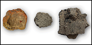
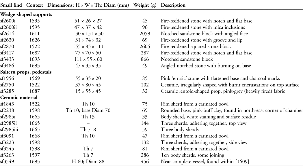
A total of 18 wedge-shaped worked stones are associated with the saltern. These stones, along with 27 ceramic items, are categorised here into three groups: wedge-shaped supports, props or pedestals and a possible clip, and ceramic material (Figures 8–10 & Table 2). The wedge-shaped stones are considered to have supported a structure upon which clay vessels were placed. Typologically, many of these shaped stones resemble others found in Middle to Late Bronze Age and Iron Age salt-working assemblages, but are previously unknown or unrecognised in Neolithic contexts in Britain.
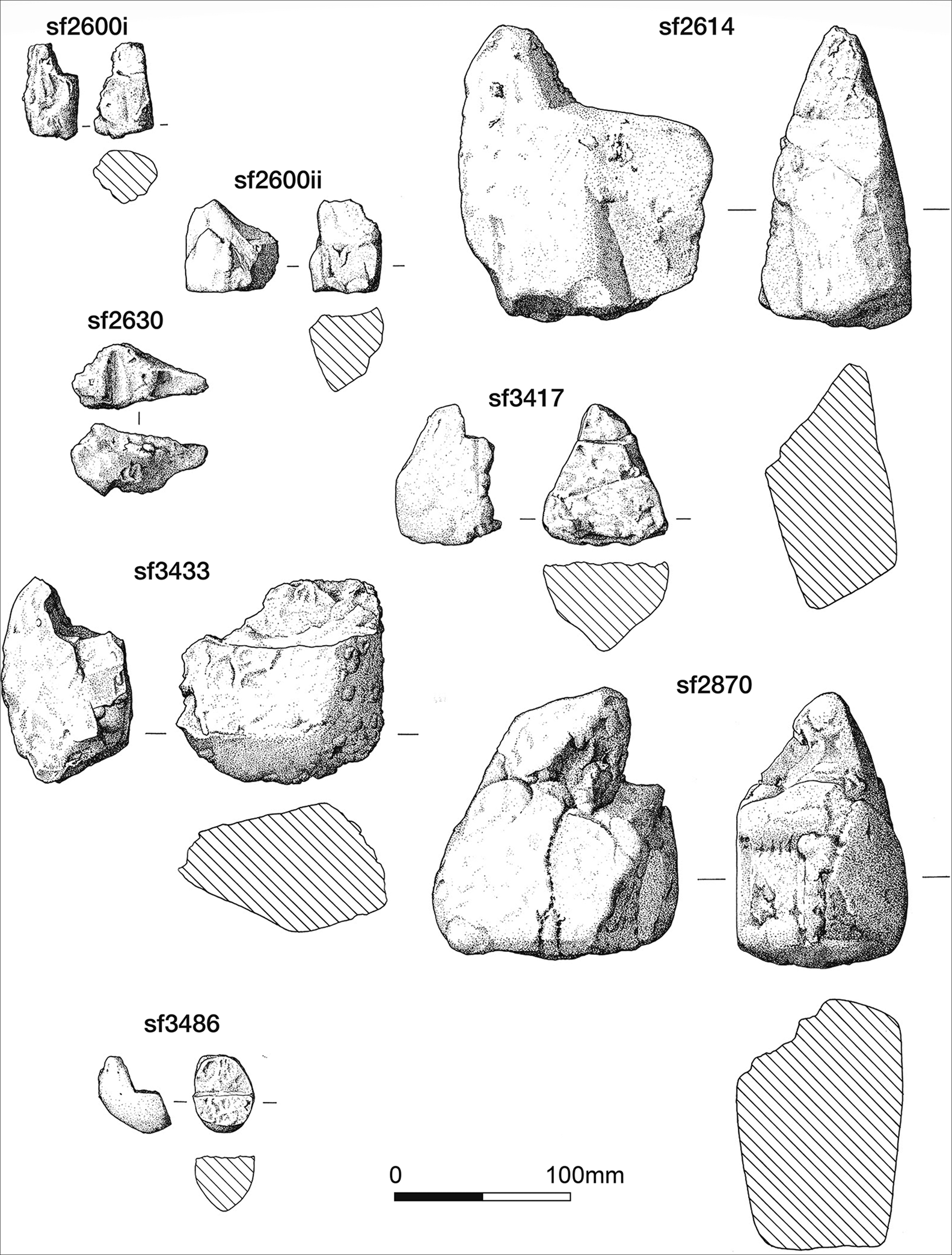
Figure 8. Selected saltern furniture (drawn by L. Hutchinson).
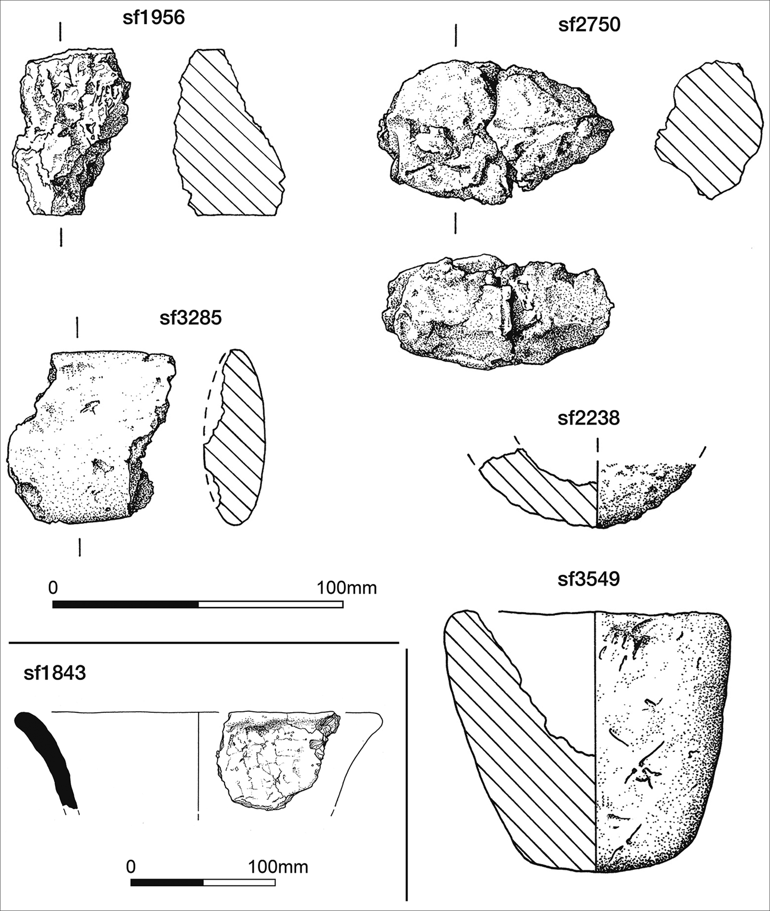
Figure 9. Saltern props and ceramic vessels (drawn by L. Hutchinson).

Figure 10. Examples of sherds from the saltern (photographs by S.J. Sherlock).
Table 2. Selected finds from the Street House saltern (H = height; W = width; Th = thickness; Diam = diameter).
Over 750 sherds of Neolithic pottery and more than 40 fragments of baked ceramic material, weighing approximately 4kg in total, were recovered from phase-2 and -3 deposits. While the assemblage has yet to be fully analysed, initial cataloguing indicates that the majority of the vessels are of the type of carinated bowl known from the Early Neolithic period (Figure 9: sf1843). No complete pots were found within the chamber, although base fragment sf2238 was found at the north-east edge of hearth [1707], and near-complete vessel sf3549 was found on the south side of hearth [1689] (Figures 3 & 9). A number of sherds found around the hearths have a milky white surface patina (Figure 10: sf2985i). This appears to resemble salt-scale (Sherlock Reference Sherlock1921: 13) and is described on vessels of later date from Cowbit in Lincolnshire (Morris Reference Morris, Lane and Morris2001a: 41). To confirm this interpretation, X-ray fluorescence (XRF) analysis has focused on the identification of chlorine (Cl). The results suggest significant variation in the amounts of chlorine measured in sherds of Neolithic pottery from 1m above the saltern in phase-3 deposits, unwashed sherds from soil samples from phase 2, sherds directly associated with the phase-2 saltern, and a control group of Romano-British sherds from features excavated in the same field in 2013 (Marks Reference Marks2021).
The vessel assemblage comprises predominantly broken body sherds—some conjoining and some found in stacked heaps—and rim sherds from carinated bowls. The vessel walls vary between 6 and 12mm in thickness and are coarsely tempered with medium to large white quartz and quartzitic grits, and organic matter. The interior surfaces of the vessel sherds are consistently heavily abraded, and, where surviving, exterior surfaces exhibit fingertip and fingernail impressions, and are occasionally burnished.
Discussion
Excavations at Street House have revealed an Early Neolithic feature with no known direct parallels in Neolithic Britain. Three possible interpretations for the burnt phase-2 feature are considered here. First, could the feature be a “crematorium”, similar to sites excavated and described by Mortimer (Reference Mortimer1905: 247) on the Yorkshire Wolds in the nineteenth century? This interpretation can be dismissed because no human bone has been identified in any of the samples of burnt material collected. If bone had been present in the phase-2 feature, it should have survived, given that human bone was found at the cairn and mortuary structure just 250m to the north-west of the site (Vyner Reference Vyner1984).
A second possible interpretation is a pottery kiln, based upon the shape of the feature, evidence for intense burning and the hundreds of ceramic sherds found within the feature. Wasters, in the form of distorted, shattered or spalled pots, however, are often associated with pottery kilns, and no such vessels or damaged sherds are associated with the Street House feature. Moreover, pottery kilns similar to the Street House structure are currently unknown from the Neolithic period in Britain. It is a presumption that, at this time, pots were fired in features more akin to a bonfire, perhaps through to the Late Bronze Age (Brown Reference Brown2016: 5).
The third possibility is that the feature is a saltern. This interpretation rests on the distinctive characteristics of the artefact assemblage for which there are parallels from a number of salt-working sites in Britain of Bronze Age and Iron Age date. A recent study of salt production presents evidence for 31 Bronze Age sites in Britain, the earliest evidence coming from Brean Down in Somerset, dating to c. 1400 BC (Bell Reference Bell1990: 165; Kinory Reference Kinory2012: 12 & 14). At the Late Bronze Age site at Billingborough in Lincolnshire, briquetage and ceramic pedestals with broad bases were found in pit 78256, with an associated radiocarbon date of 2500±100 BP (HAR-3101: 840–390 cal BC; Chowne et al. Reference Chowne, Cleal and Fitzpatrick2001: 92). Late Bronze Age salt-working equipment, including cupped pedestals and props, was recovered from both the North and South Rings at Mucking in Essex, and “flues” were noted (Barford Reference Barford, Evans, Appleby and Lucy2016: 197). Examples of supports and structural material similar to that found at Street House—albeit ceramic rather than stone—have been found at Iron Age sites in Lincolnshire, where angled pieces and pedestals were used to raise vessels above the direct heat of the fire (Lane & Morris Reference Lane and Morris2001: 50; Morris Reference Morris, Haselgrove and Moore2007: 437).
Beyond Britain, in Central Europe, Harding (Reference Harding2017: 44) has published evidence for Neolithic salt production in both Poland and the Balkans. The site at Kraków-Rżąka 27 in Poland yielded briquetage vessels from the pre-Cucuteni and Cucuteni Cultures (Harding Reference Harding2017: 55), which are visually similar to the Street House ceramic vessels. The site of Poiana Slatinei in Romania, with its associated Criş pottery and a nearby salt well, has yielded a broad range of Neolithic dates, and is arguably the earliest salt-production site in the world, dating to 6050–5500 BC (Weller & Dumitroaia Reference Weller and Dumitroaia2005).
A few other European examples provide useful, although later, parallels for the Street House material. There is Late Neolithic evidence for brine evaporation at coastal sites in Spain, and at the third-millennium BC Molino Sanchón II, Zamora, Spain, brine was extracted from a lake (Guerra Doce et al. Reference Guerra Doce, Moras, Castro, Lazaro, Recio, Martínez and Salanova2015: fig. 15.3.3; Weller Reference Weller2015: 194 & fig. 8). At Molino Sanchón II the brine was evaporated within coarse ceramic pots with rounded bases, which were placed on clay pedestals (Guerra Doce et al. Reference Guerra Doce, Moras, Castro, Lazaro, Recio, Martínez and Salanova2015: 172, fig. 15.3.3). These pots resemble Street House vessel sf2238 (Figure 9). The salt cakes formed following evaporation were then extracted by breaking the vessels (Guerra Doce et al. Reference Guerra Doce, Moras, Castro, Lazaro, Recio, Martínez and Salanova2015: fig. 15.3.6). While the number of sherds at Molino Sanchón II was considered to be substantial (approximately 30 000 sherds)—partly as the result of breaking the vessels to retrieve the salt cakes—there were many Beaker sherds placed around the drying area as deliberate ritual deposition, described by the excavator as “votive offerings” (Guerra Doce et al. Reference Guerra Doce, Moras, Castro, Lazaro, Recio, Martínez and Salanova2015: 172). At Street House, clusters of pottery sherds—broken and stacked—were recorded around the edge of the hearths (Figure 10: sf2985ii & sf3223). While it is unknown whether these also represent ritual deposits, I suggest that the position of these sherds probably reflects a functional task of the salt-working process, rather than ritual deposition.
A review of ceramic evidence from coastal sites in western France has also identified potential salterns at Champ-Durand (Vendée), Couture (Charente-Maritime) and La Sauzaie (Charente-Maritime) dating to 3400–2900 BC (Ard & Weller Reference Ard, Weller and Joussaume2012: fig. 281). At Champ-Durand, the pottery from an internal ditch has also been examined by XRF, and high levels of chlorine detected (Ard & Weller Reference Ard, Weller and Joussaume2012: figs 266 & 277). The pottery from Street House is visually similar to the ceramic vessels from Champ-Durand and Couture (Ard & Weller Reference Ard, Weller and Joussaume2012: fig. 274; see Figure 10). At La Sauzaie a feature initially interpreted as a potter's kiln could be a saltern (Pautreau Reference Pautreau1974; Ard & Weller Reference Ard, Weller and Joussaume2012: 328–29).
Compared to these European sites, the dates for salt-working at Street House are earlier than those for the sites in western France and Spain, but post-date those in Poland and the Balkans. It is now apparent that the saltern feature at Street House dates to the “Carinated Bowl Neolithic” strand of Neolithisation, considered to be a migration from the Nord-Pas de Calais of north-western Europe to the British Isles between 4000 and 3800 BC (Sheridan Reference Sheridan, Whittle and Cummings2007, Reference Sheridan, Hey and Frodsham2021: 180–81). While the saltern feature dates to 3800–3700 BC, the salt-working technology probably arrived with these migrating people. Cultural material from the Street House site includes Carinated Bowl ceramics and lithics, including leaf-shaped arrowheads, as well as archaeobotanical evidence for cereal cultivation. Analysis of lipid deposits from some of the Street House Carinated Bowls indicates an element of dairy processing (I. Wiltshire, pers. comm.), possibly for consumption—a practice recognised elsewhere in the Early Neolithic (Cramp et al. Reference Cramp, Jones, Sheridan, Smyth, Whelton, Mulville, Sharples and Evershed2014).
Based upon the artefacts and excavated evidence from Street House, I can suggest the following stages for salt production, further developing the châine opératoire described for the Zamora site (Guerra Doce et al. Reference Guerra Doce, Moras, Castro, Lazaro, Recio, Martínez and Salanova2015: 170):
1. Collection of seawater, which is evaporated into a more concentrated brine solution and transported to the site. This process may have taken place at Skinningrove, the nearest point with suitable beach access.
2. Transfer of brine into storage tank [1531] via the wooden chute.
3. Decanting the brine from tank [1531] into vessels over the three hearths [1689, 1690, 1707]. The vessels could have been placed on a timber frame supported by the stone and ceramic props. The timbers may have been pre-soaked and positioned so as to withstand indirect heat from the hearths.
4. Evaporation of brine leading to crystallisation into salt cakes within the vessels.
5. Breaking the ceramic vessels to obtain the salt cakes. The abraded internal surfaces of sherds from Street House and from sites in western France (Ard & Weller Reference Ard, Weller and Joussaume2012) may have occurred during the extraction of the salt cakes from the vessels.
6. A final stage is proposed in which the salt cakes are reshaped into a standard size for transport and exchange.
The production of salt by evaporation was only possible at certain times of the year (Morris Reference Morris, Lane and Morris2001b: 404). In the Early Neolithic, salt was a rare commodity, probably reserved for special occasions or for selected individuals, but the waste product formed by the debris from this process could have been given to animals as salt licks (Kinory Reference Kinory2012: 105).
The question emerges as to why no other Neolithic salt-works have been found in Britain. There are known Iron Age sites in the so-called “Briquetage Zone” above high water level on the coasts of eastern and southern England, between Lincolnshire and Poole Harbour in Dorset (Harding Reference Harding2017: fig. 7.1). As sea level along the Yorkshire coast was approximately 2.50–3m lower in the Neolithic than today, coastal locations where salt could have been produced are now possibly >200m offshore, based on the evidence from around the Tees estuary and the coastline between Teesmouth and Saltburn (British Geological Survey 2016: P916107.jpg, Teesside). A study of the cliff between Huntcliff Station and Robin Hood's Bay found evidence for erosion at the rate of 0.075m per annum (Lim et al. Reference Lim, Petley, Rosser, Allison, Long and Pybus2005), which, if extrapolated back 6000 years to the Early Neolithic, means that Street House would be 450m farther from the sea than it is today. I suggest that Neolithic salt-working sites along the east coast of England have been lost due to rising sea levels and coastal erosion, but where they do exist they are likely to be found where the geology favours survival, such as on the Northumberland coast, and they will be associated with other evidence for Neolithic activity.
Neolithic activity at Street House appears to have exploited Mesolithic clearings. Daily tasks, such as foraging and grazing, may have taken place within an area of at least a 4–5km radius to incorporate access to the foreshore at Skinningrove (accounting for lower sea levels in the Neolithic and coastal erosion). In addition to establishing a new settlement, salt production was pioneered here, and we can envisage local exchange, with the nearest known site 7km to the south, at Newton Mulgrave cairn (Spratt Reference Spratt1993: 77). A wider exchange network should also be considered—one which may have included objects in addition to stone tools and salt—that could be associated with status, such as stone axes from outside the area (e.g. the polished axe from Borrowdale, Cumbria, excavated from the façade trench of the Early Neolithic cairn; Vyner Reference Vyner1984: 175).
Clearly, the range of Neolithic evidence at Street House indicates a significant concentration of activity, with the Early Neolithic cairn and mortuary structure to the north-west and house (structure 16) to the north-east. The setting is important as all sites are intervisible. The saltern is on a ridge and can be seen from the valley to the east. This site is protected from winds from the north and west, and thus sheltered to enable the control of the pyrotechnology needed to transform a liquid into a solid. The use of fire will have been a special and memorable event, perhaps only to be eclipsed by the ceremonial burning of the mortuary structure (Griffiths Reference Griffiths2011: 320; Table 1).
As salt is an essential staple, the control of quantity and supply is crucial within societies, but status is also reflected through ownership as a symbol of wealth (Weller Reference Weller2015: 194). At other Neolithic salt-working centres in Europe, the communities regulating the production and distribution of salt benefited from great wealth. The site of Provadia-Solnitsata in Bulgaria, for example, flourished between 5500 BC and 4900 BC as a vast urban centre with a salt-production area extending over 0.50ha, and a large number of Linearbandkeramik settlements in the Schwäbisch Hall area in Germany developed around sources of salt (Harding Reference Harding2017: 44 & 47). Although Street House is not comparable to these European examples in terms of scale, the concentration of monuments at this location may be a reflection of significant investment in a nascent, thirty-eighth-century BC salt ‘industry’.
Conclusions
The results of recent archaeological investigations at Street House in north-east England have recovered evidence for the first known example of specialised salt production in Neolithic Britain. A saltern with hearths for the heating of brine in ceramic vessels has parallels in later periods of British prehistory and from Neolithic sites in Eastern, Central and Western Europe. Salt production was associated with a nearby Early Neolithic house and funerary cairn, and human activity at Street House extends back to the Late Mesolithic. It is notable that salt-working occurred at Street House at a time of dietary change from marine to dairy products, and that this is associated with the Carinated Bowl Neolithic migration from the Nord-Pas de Calais.
The full extent of salt production at the site is still to be determined. The geophysical survey that prompted the sub-surface investigations reported here identified a second, similar anomaly 10m to the north, suggesting the possibility of another saltern or associated feature, and therefore a much larger scale of operation. The implications of salt-working in Neolithic Britain are wide ranging, and the evidence from Street House will initiate debate over the mechanisms of the production, distribution and consumption of salt, its potential utilisation in craft-working, as well as its importance in ritual and status.
Acknowledgements
I am grateful to the landowner, Tony Garbutt, for permitting access to the site, and to my small team of willing excavators who come each year. Particular thanks to Phil Abramson, Mel Dalton, Linda Davies, Andy Hoaen (University of Worcester), Sue Jackson, Pete Johnson, James Lawton (geophysics), Rob Nichols, Jenny Parker, Bruce Webb-Ireland and Isabel Wiltshire (University of Bristol). Blaise Vyner kindly commented on the pottery found in 2016, and Spencer Carter and Rob Young commented upon flint from the excavations. Malin Holst examined potential bone samples. Yvette Marks (Department of Archaeology, Sheffield University) examined pottery samples by XRF. Lester Jones provided technical graphics support. I would like to thank Janice Kinory for discussions on salt in the spring of 2020. Andrew Fielding kindly commented on an earlier draft of the text, and Anthony Harding, Tom Lane, Elaine Morris and Steven Willis encouraged my ideas for the function of the feature. All errors, however, remain with the author.
Funding statement
This research received no specific grant from any funding agency or from commercial and not-for-profit sectors.


