


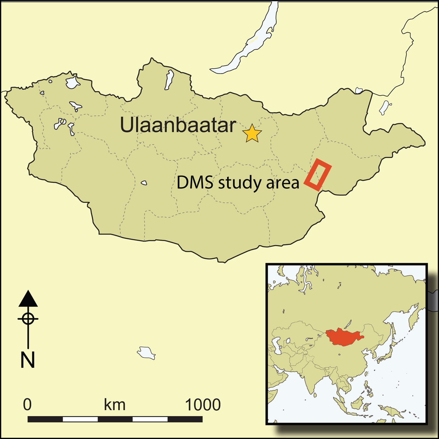
The Eurasian Bronze Age is one of the great archaeological horizons of the world. Across the vast grasslands and mountainous regions of the Steppe, mobile populations have left exquisite metallurgy and extensive mortuary monuments (Chernyk Reference Chernykh1992; Anthony Reference Anthony and Mair1998; Koryakova & Epimakov Reference Koryakova and Epimakov2007; Shelach Reference Shelach2009; Hanks Reference Hanks2010; Simpson & Pankova Reference Simpson and Pankova2017). This article uses regional archaeological data from prehistoric Mongolia to recast the established narrative of a relatively homogeneous Eurasian Bronze Age, based on common social and cultural developments, to one of local agency—a multifaceted and diverse process, responding to both regional conditions and continental trends. We focus on archaeological material related to the Ulaanzuukh mortuary tradition (Tumen et al. Reference Tumen, Dorjpurev and Mayagmar2013)—the earliest-dated monumental record in south-eastern Mongolia. These data allow us to investigate the archaeological context and interrelationships of the earliest, characteristically Bronze Age material culture in the south-eastern Gobi Desert. Located in the Sukhbaatar and Dornogovi aimags (provinces) of Mongolia (Figure 1), the study area is a semi-arid steppe region famous today for its horses and metal resources. In prehistory, it was situated between the established farming communities and early states of the Yellow River watershed to the south, and the well-watered and forested Khangai Highlands and Kherlen Valley to the north. This latter region gave rise both to the historical steppe empires and a rich Iron Age archaeological record (Shelach Reference Shelach2009; Honeychurch Reference Honeychurch2015).

Figure 1. The northern section of the DMS study area showing the focal study areas within it (figure by J. Wright).
The Eurasian Bronze Age is known from extensive research in regions such as the Minusinsk basin of Siberia, through which the macro-regional cultural sequence has been defined (Kiselev Reference Kiselev1937; Legrand Reference Legrand2006). The wide distribution across Eurasia of similar material culture, languages and Central Asian domesticates has long made the spread of Bronze Age culture a compelling topic, with researchers seeking to define clear and concise packages of identity, material culture and genetics (Boyle et al. Reference Boyle, Renfrew and Levine2002; Anthony Reference Anthony2007; Frachetti Reference Frachetti2011). These models of homogeneous processes have been critically examined in other regions (see Koryakova & Epimakov Reference Koryakova and Epimakov2007; Popova Reference Popova, Hanks and Linduff2009), but Mongolia is a particularly valuable case study because of its geographic separation from the majority of the Eurasian Steppe and its rapidly developing archaeological research trajectory that supports robust local studies. Recent work by the Dornod Mongol Survey (DMS) and others (e.g. Tumen et al. Reference Tumen, Dorjpurev and Mayagmar2013; Amartuvshin et al. Reference Amartuvshin, Batbold, Eregzin and Batdalai2015; Janz et al. Reference Janz, Odsuren and Bukhchuluun2017) makes it possible to define the probable earliest Bronze Age cultures of the Gobi region as both practitioners of familiar Middle Holocene adaptive strategies used by communities in response to local needs, but also as communities whose choices resonated with macro-regional trends. This article contributes to the discussion of the extent to which the Eurasian Bronze Age is defined by social and political conditions, technological manifestations or typological patterns (Chernykh Reference Chernykh1992; Kristiansen & Larsson Reference Kristiansen and Larsson2005; Kohl Reference Kohl2007; Shelach Reference Shelach2009).
The material evidence of the Ulaanzuukh culture can, for all practical purposes, be considered Eneolithic, in that it displays attributes of both the preceding Epipalaeolithic hunter-gatherers and the succeeding Bronze Age cultures, but with no evidence for the production or use of bronze objects (Tumen et al. Reference Tumen, Dorjpurev and Mayagmar2013; Amartuvshin et al. Reference Amartuvshin, Batbold, Eregzin and Batdalai2015). As with other archaeological cultures in Eurasia (Anthony Reference Anthony and Mair1998; Shishlina & Hiebert Reference Shishlina, Hiebert and Mair1998), however, scholars often present these transitional cultures as being the first of the Bronze Age, rather than the last of the Epipalaeolithic. With that in mind, we view this period as one of consolidation that laid the groundwork for the growth of regional polities and the traditions that would develop fully by the Late Iron Age.
The period that succeeds the earliest Bronze Age—known as the Late Bronze Age and Early Iron Age in Mongolia (c. 3200–2300 BP), or the Late or Terminal Bronze Age in the Eurasian Steppe (Hanks Reference Hanks2010; Honeychurch Reference Honeychurch2015)—is characterised by several practices considered emblematic of the Eastern Eurasian Bronze Age. These include long-range connections and regional hierarchies that are visible through syncretic iconography (Volkov Reference Volkov1981; Jacobson Reference Jacobson1993; Fitzhugh Reference Fitzhugh, Bemmann, Pohl and Tseveendorzh2009); the strengthening of elite management of long-range exchange systems (Honeychurch Reference Honeychurch2015); macro-regional mortuary traditions with regular burial forms and settings (Hao Reference Hao1988; Erdenebaatar Reference Erdenebaatar1992; Törbat et al. Reference Törbat, Giscard, Dunbüree, Bemmann, Pohl and Tseveendorzh2009); widespread monumental types, suggesting regular mobility and shared architectural traditions (Tsybiktarov Reference Tsybiktarov and Konovalov1995; Wright Reference Wright2007; Houle Reference Houle, Hanks and Linduff2009; Liu Reference Liu2014); and the establishment of historically familiar mobile pastoralist economies (Makarewicz Reference Makarewicz, Brosseder and Miller2011, Reference Makarewicz2015; Taylor Reference Taylor2017).
We argue that the earliest Bronze Age in the Gobi was defined by its creation of monumental social spaces, rather than by metallurgy or domestic animals, and that these places were arenas in which changing political relationships were enacted. We define ‘politics’ in the broadest sense—as social relations of a group organised and materialised towards particular social goals (DeMarrias et al. Reference DeMarrais, Castillo and Earle1996; Johansen Reference Johansen, Johansen and Bauer2011). Societies in the south-east Gobi region 4000–3000 years ago negotiated transformations in their environment, regional networks and social hierarchy. The most visible archaeological manifestations of these emerging societies are their monumental spaces.
The Dornod Mongol Survey
The DMS is an ongoing regional survey, excavation, ethnoarchaeological and palaeoenvironmental research project based in south-eastern Mongolia (Figure 1). The study region encompasses 7000km2 and includes a range of steppe environments, from playa basins to arid sandy uplands, grasslands and rocky hill ranges that form islands of environmentally richer conditions compared to the less hospitable surrounding environment. Within this area we have focused on a subset of distinctive areas totalling 520km2, intensively surveying 97km2 in which we have recorded all monumental and architectural sites and detected artefact scatters as small as 2m2. This has provided a sample of all but the rarest site types and has also allowed us to assess monumental features alongside habitational evidence.
Ulaanzuukh-type monuments
The study of monuments is the study of place-making and the creation of social spaces (Kuper Reference Kuper1972; Bradley Reference Bradley1993; Osbourne Reference Osbourne2014; Núñez et al. Reference Núñez, Cartajena, Carrasco, Mendoza, de Souza, Rivera, Santander and Loyola2017). This includes mortuary monuments and graves, but also a range of other related constructions. In the Gobi region, all of these display common elements and building techniques that could have made up a broadly understood architectural style. The builders of these structures comprised a community of practice (Sassaman & Rudolphi Reference Sassaman and Rudolphi2001; Wendrich Reference Wendrich2012)—learning and reproducing monumental forms and the meanings that went with them. Here we present together a range of mortuary and non-mortuary monuments as a record of both local societal actions and common regional ideologies.
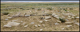
The Ulaanzuukh mortuary tradition has been defined on the basis of a number of previous burial excavations (Navaan Reference Navaan1975; Tumen et al. Reference Tumen, Dorjpurev and Mayagmar2013; Honeychurch Reference Honeychurch2015: 122–26). The DMS has now documented more than 500 burial monuments of this type, as well as hundreds more associated features. There are several related monumental forms highlighted in our reconstruction of the earliest Bronze Age landscapes of the south-east Gobi region (Figures 2–5). First, the burial monuments themselves comprise rectangular stone structures with a shallow burial pit inside a low enclosure filled with stones. The enclosures are defined by short (approximately 0.4m high), well-constructed walls of flat stones standing several courses high. Against these walls are placed many upright flat stones (Figure 3). These monuments are found in a range of sizes from 1.4–13.5m in length, but average 4.8±2m, with a consistently east-north-east orientation (77±26°). Human interments are extended and prone—a burial tradition found across the Gobi region in several different, but structurally related, monument forms (Kovalev & Erdenebaatar Reference Kovalev, Erdenebaatar, Bemmann, Pohl and Tseveendorzh2009; Tumen et al. Reference Tumen, Dorjpurev and Mayagmar2013; Ma Reference Ma2017). In some cases, these burials have plain standing stones approximately 1m in height placed several metres from the southern or eastern ends. In rare cases, the tops of these stones may show signs of having been roughly shaped. Multiple burial monuments can be found arranged in chains—groups of rectangular burials built with their long sides almost adjoining. Typically, the largest monument is placed at one end of the chain, and there are fewer than 10 burials in any group (see Tumen et al. Reference Tumen, Dorjpurev and Mayagmar2013: fig. 2). Excavated examples have shown that individuals buried in these connected graves can belong to similar (e.g. mostly males of a similar age range) or diverse (e.g. adults and children) demographic groups. In both cases the chains are built within a period of one to two centuries or fewer (Table 1), suggesting that they were related in life and an ongoing memorial tradition in the community.

Figure 2. Ulaanzuukh-type burials and burial chains: a) & c) typical burials with the slab wall and leaned slabs visible; b) a burial chain (images courtesy of the DMS).

Figure 3. Slab-built wall of a large Ulaanzuukh burial monument, with an in situ leaning slab covering the wall (image courtesy of the DMS).
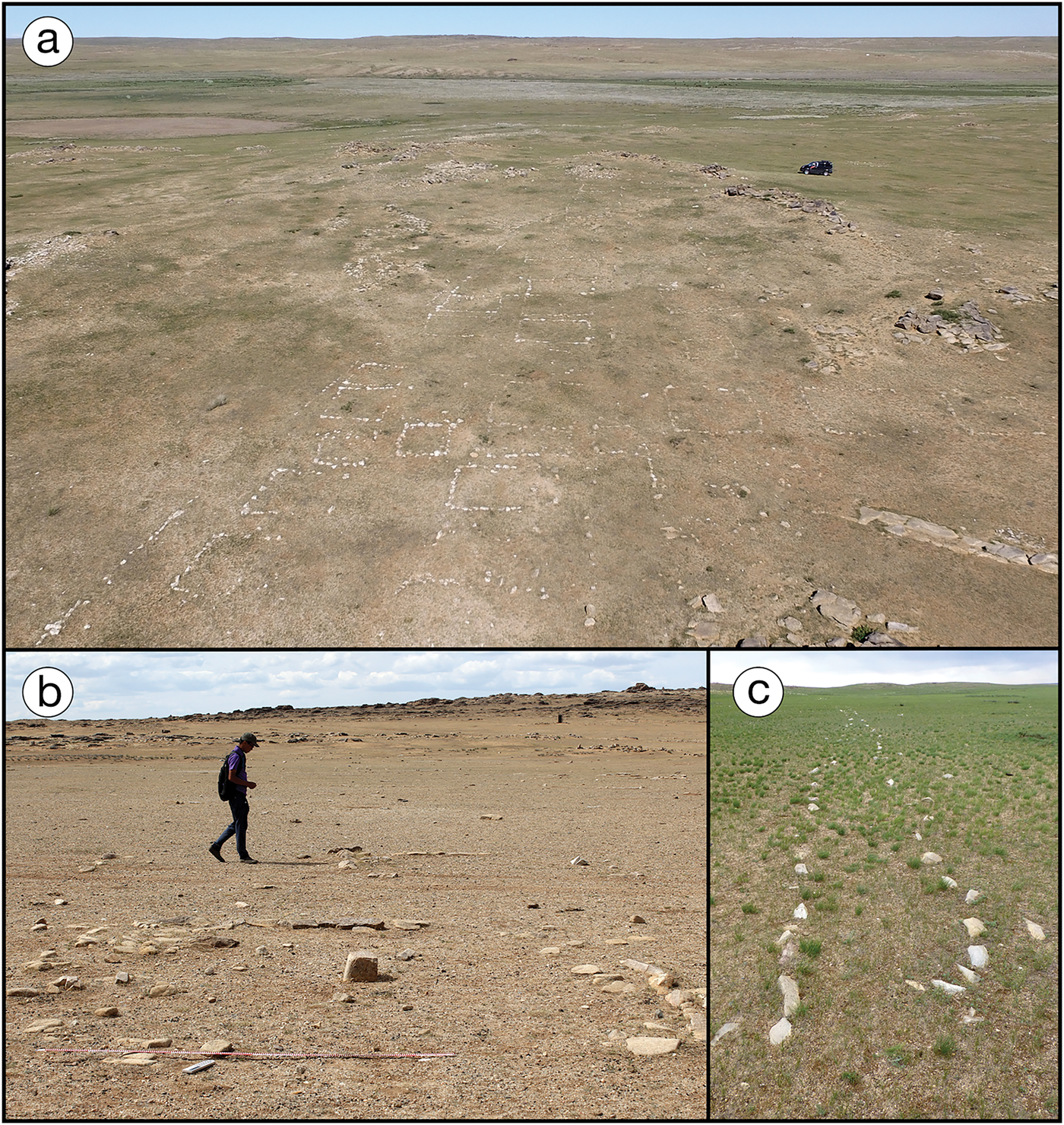
Figure 4. Ground-level features associated with Ulaanzuukh-type burial monuments: a–b) rectangular enclosures, with a cubical centre stone visible in B; c) a parallel set of long alignments (images courtesy of the DMS).
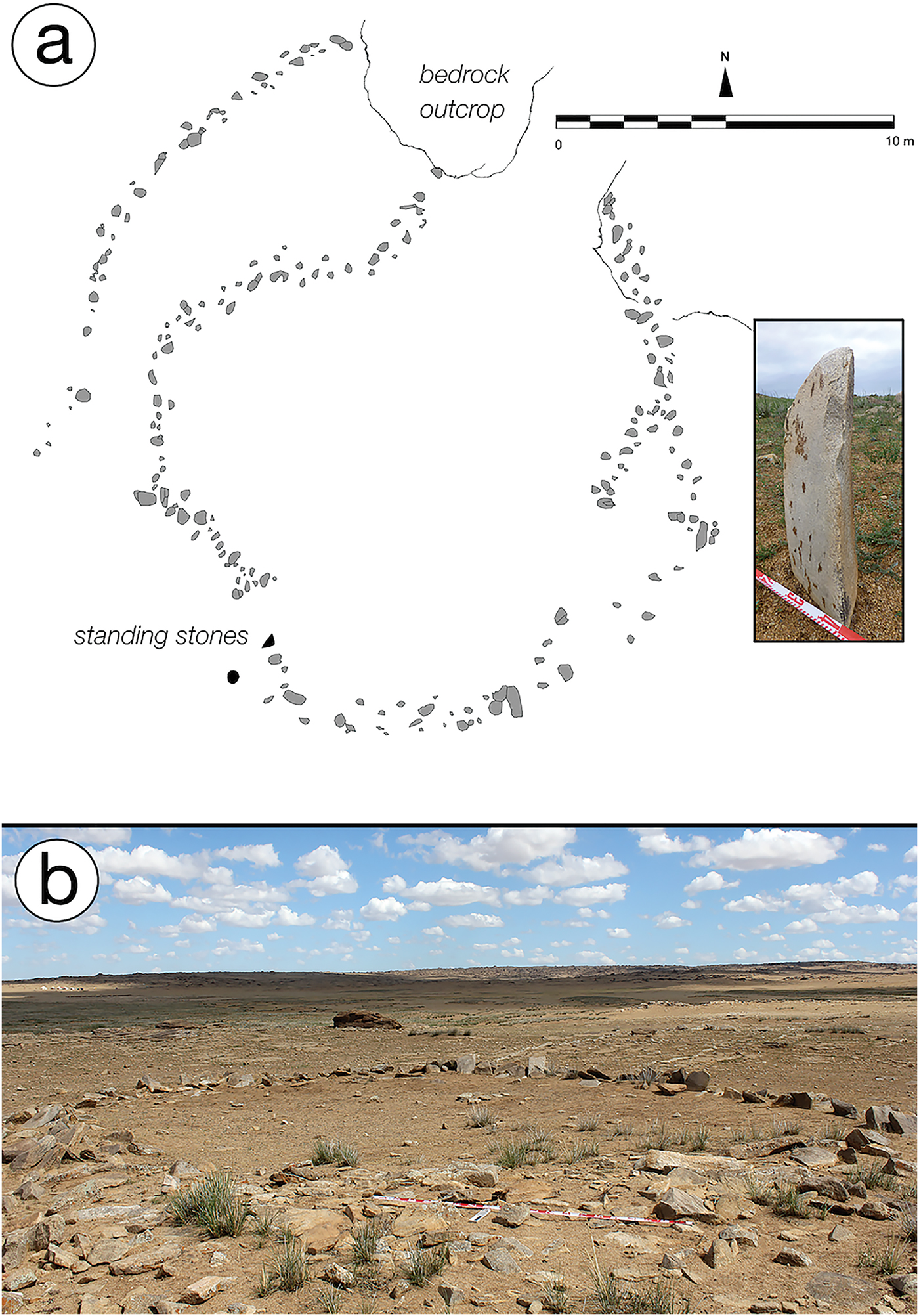
Figure 5. Circular features associated with Ulaanzuukh monuments: a) an example with secondary arcs, a northern bedrock outcrop and standing stones (inset of a) marking the path that turns sharply into the interior; b) a complete circle without any accompanying monuments or outcrops (images courtesy of the DMS).
Table 1. Radiocarbon dates for the earliest Bronze Age and associated contexts from a range of sites and monuments in the south-eastern Gobi region of Mongolia.

1 All calibration and date spans carried out using OxCal online version 4.3 (https://c14.arch.ox.ac.uk/oxcal/OxCal.html) using the IntCal13 calibration curve (Bronk Ramsey Reference Bronk Ramsey2009; Reimer et al. Reference Reimer2013).
In addition to these more widely recognised mortuary monuments, there are other structures, the dates of which are defined by their association with the burial monuments (Figure 4). These associated structures include rectangular enclosures with outlines defined by single-course stone alignments. They are larger than the burial monuments, with a long axis of 6.2±1.6m and an average enclosed area of 34.3m2. Typically, they have an opening in the alignment on the short side, oriented to the south. They may have additional small pavements on the long west side and a cubical stone set into the ground near the centre. Similar stones can be found forming a pair of rows, comprising 2–3 stones extending south from the opening in the main enclosure. These structures can occur singly, but are more frequently found in groups placed side by side in lines. The lines can be long (many tens of metres) and the upstanding entrance stones can appear as alignments perpendicular to the openings in the enclosures.
The second type of structures are long rays. These are ground-level alignments of stones that are found both as pairs of lines that converge on another monument, or as single long lines that may curve slightly at their ends. The DMS has recorded nine examples of these features—all of east-north-east to west-south-west orientation, irrespective of terrain and of an average length of 121±33m. Most have a burial at their eastern end, although three are without any apparent features at either end. Ray-alignment orientations parallel the grave axes, thus tying these two structures together, even when they are not built close together.
The final monument feature type is circles (Figure 5), constructed of standing flat stone or slabs similar in size and style to those set around burial mounds. Two examples have been completely excavated (Tumen et al. Reference Tumen, Dorjpurev and Mayagmar2013). DMS has recorded 45 examples located in a wide variety of settings. The circles measure 10.3±3m in diameter and contain no additional features or artefacts. In some cases, there are hints in the surviving structures or open spaces within the circle that could have directed access into or out of it. Circles appear in three formats: first are those either near or connected to a larger burial monument (n = 35). Such monuments directly associated with circles are significantly larger than most (7.3±1.9m in length, t = −5.74 p < 0.0001, using a two-tailed-t-test). Large burial monuments and circles can occur singly and they are not limited to sites with many monuments; the median number of monuments in a chain, with an associated circle, is 3–4.
The second type of circles are without an associated burial monument (n = 7), but which are often built around a natural rock outcrop in the northern quadrant of the circle. The accessible southern openings and blocked northern sides of both the rectangular enclosures and circles suggest another common axis for active monumental spaces. Finally, there is a larger and more elaborate variety of circle, with parallel arcs and defined entranceways (n = 3). These are monuments with defined approaches that lead to sharp turns at the entrance of the circle. Burial monuments or natural outcrops incorporated into the ring of each circle suggest an orientation towards them within the space. In two of the three recorded examples, the approach arcs face towards, or directly connect to, former wetland areas.
The demarcations of space created by stone alignments and structures around and within monumental complexes could have served to structure community politics by positioning people within places in the landscape. As orientated spaces with structured entrances and exits, and a clear demarcation of participants and observers, circles could have been important for structuring activity around graves. These circles demonstrate increased investment in the original building of the burial monuments. The pay-off from such investment, however, is uncertain. Higher initial investment did not necessarily produce, or may not have needed to produce, a long sequence of burials following initial monument construction, as may be assumed if the interred individual was an important member of an established lineage. Circles also have a connection to the characteristics of the landscape, a pattern repeated in the burial monuments themselves. Rough stone slabs—seen also in circle construction—are placed around and against well-built grave walls, in what may have served to reconnect the graves to the natural rock-filled landscape in which they were built (Bradley Reference Bradley2000; Bender et al. Reference Bender, Hamilton and Tilley2007).
The low walls of flat stones are a key element of burials both in this region and across a wide area of the Gobi (Kovalev & Erdenebaatar Reference Kovalev, Erdenebaatar, Bemmann, Pohl and Tseveendorzh2009; Tumen et al. Reference Tumen, Dorjpurev and Mayagmar2013; Ma Reference Ma2017); they are found only in burial monuments. The same repetition is true of the off-set standing stones recorded at some burials. These similar component elements tie the monuments recorded by the DMS to a supra-regional set of meanings and traditions, suggesting common regional identities and ways of memorialising and politicising local landscapes (Bauer Reference Bauer, Johansen and Bauer2011). Each monumental element's meanings may have been clarified by the fact that each one can be found in isolation, without their typically associated elements; a single row of cubical stones, or a lone circle or standing stone could have been evocative of the whole associated complex of elements and social relationships.
The habitation sites
In contrast to the extensive and detailed monumental record, the evidence for the Ulaanzuukh settlement consists of scatters of ceramics and chipped stone. These scatters have yielded a consistent pattern of thin-walled red ceramics with a granular fabric (Figure 6), and chipped-stone debitage and tools from a microblade and small flake-based industry. Such ceramics and formal tool assemblage have also been found in Ulaanzuukh burials (Tumen et al. Reference Tumen, Dorjpurev and Mayagmar2013), including wide-mouthed tripod vessels with small conical hollow feet (Tumen et al. Reference Tumen, Dorjpurev and Mayagmar2013: fig 4; Amartuvshin et al. Reference Amartuvshin, Batbold, Eregzin and Batdalai2015). Despite the complex stone burial monuments associated with the material culture within these scatters, no architecture has been found at any of these sites (for a contrast, see Jia et al. (Reference Jia, Betts, Cong, Jia and Dupuy2017) for large architectural structures in the Bortala Valley of the Xinjiang). This stone tool industry is part of the broader East Asian microlithic tradition, for which definitive local and chronological divisions are not yet defined. Hence, ceramics are the major identifier of Ulaanzuukh-period surface scatters. Those scatters that include ceramics range from 2–7558m2 (averaging approximately 1000m2 (n = 71)). The scatters have a median density of one object per 11.8m2, with around 25 per cent of those objects being small pottery sherds. The relative size and level of preservation of artefacts is similar between scatters. We interpret these scatters as the remains of activity areas or temporary habitation sites that were part of a shifting settlement system—perhaps for groups of ceramic-using hunter-gatherers that were typical across much of Eurasia and East Asia (Jordan & Zvelebil Reference Jordan and Zvelebil2006; Lee Reference Lee2011).

Figure 6. Mid to Late Holocene ceramic rims: item F is an example of a ‘net-impressed’ ceramic type (see Table 1); B and D show deep quatrefoil indents; item C is a red-slipped fine ware, while all others are coarse and without surviving surface treatment (figure by J. Wright).
Distinct landscape contexts are key to the settlement patterns of this period. Artefacts are found at former wetland edges and atop shallow draws, bluff edges, ridges and hilltops, or terraces overlooking wetlands. This pattern is distinguishable from the locations of later habitation, which concentrated in interfluvial areas and on highly visible hilltops; wetland edges were not heavily settled. The largest Ulaanzuukh-period artefact scatters are found in the hills of Delgerkhan Uul. In this area, stream channels and wetlands provide the central axes along which burial monuments were built (Figure 7). There is a distinct group of scatters measuring around 2500m2 (n = 5) that are found in either very sheltered areas or on higher ground near wetland areas. This distribution and choice of location suggest a land-use pattern reminiscent of hunter-gatherers (Binford Reference Binford1978; Gamble & Boismier Reference Gamble and Boismier1991; Mithen Reference Mithen2000), rather than communities dependent on animals for mobility, as seen historically in this region (Mearns Reference Mearns1993; Simukov Reference Simukov2007).

Figure 7. Dense areas of monument building in the DKU area (see Figure 1) are grouped along the main drainage and the ridge of the Delgerkhan Uul to the north-east (figure by J. Wright).
Chronology
The DMS chronology is established using architectural and artefactual typology supported by radiocarbon dating and stratigraphic relationships between artefacts and monuments. The radiocarbon dates associated with the Ulaanzuukh and related prone burials, or similar grave forms (Table 1), show that the monumental tradition is focused into the three centuries between c. 3400 and 3100 cal BP. In several cases, directly dated carbon from within ceramic fabric places their dates earlier than the monumental record. When combined with the enduring chipped-stone industry of the region, this suggests an existing material culture tradition to which monuments were added starting c. 3500 BP. A similar overlap is also seen at the end of the period, where the most recent Ulaanzuukh burials overlap with later monumental forms. Based on the contexts so far dated, burial monument chains form the central cluster of the chronology, while monuments with connected circles date across the entire span of the monumental phenomenon.
Environmental context, resilience and response
Preliminary geoarchaeological field observations suggest that the period from 6000–4000 BP in the south-east Gobi region was characterised by more widespread wetlands and associated vegetation than today. After c. 4000 BP, precipitation levels changed, along with increased erosion and a transformation in the vegetation. This change is visible in a movement of sediment that exposed rocky uplands and filled valleys. These processes created a landscape akin to that seen in the region today. There is archaeological evidence for habitation both throughout this time span (Janz et al. Reference Janz, Odsuren and Bukhchuluun2017) and during the centuries of rapid landscape change after c. 4000 BP. Although there is continuity in ceramic and stone tool technologies across this environmental transition, the valleys of Delgerkhan Uul show no evidence for monument building prior to the Ulaanzuukh tradition. The first appearance of this tradition occurred soon after c. 3500 BP, and is found stratigraphically atop the exposed rocky uplands and infilled valleys.
Discussion
Our initial contrast between the earliest Bronze Age material and the succeeding Late Bronze Age and Early Iron Age focused on the development of long-range connections and regional hierarchies. Data collected by the DMS show similarities with later material that suggest the roots of these later phenomena. The DMS study area in the second millennium BC is part of a burial tradition found throughout the Gobi region. These regional commonalities suggest long-standing connections between people, which were maintained by regular exchanges that allowed for uniform developments and some persistence of burial styles (Honeychurch & Amartusvhin Reference Honeychurch, Amartuvshin and Sabloff2011; Wright Reference Wright2017; Makarewicz et al. Reference Makarewicz, Winter-Schuh, Byerly and Houle2018). Local variations, however, argue against wholesale population mobility; rather, they demonstrate a dynamic awareness of the larger culture and the mobility of some members of society (see also Frachetti Reference Frachetti2008; Honeychurch Reference Honeychurch2015; Taylor et al. Reference Taylor, Jargalan, Lowry, Clark, Tuvshinjargal and Bayarsaikhan2017). The appearance of tripod vessels and ground-stone axes evokes the Neolithic world of the Yellow River region to the south, as well as the unique Neolithic wetland periphery site of Tamsagbulag (Dorj Reference Dorj1971; Séfériadès Reference Séfériadès2004) in the grasslands 450km to the east.
The Delgerkhan Uul region is an area of intense local engagement with the landscape and continuity of habitation patterns from the Epipalaeolithic. The density of monument construction suggests a large local population, and highlights place-based resilience. In a model of emerging hierarchy, we observe the memorialisation of individuals and lineages through monument construction, but also a range of what might be called ‘misfired’ lineage monuments, evidenced in the building of single large burials and associated circles that attracted no additional peripheral structures. These may represent attempts to celebrate and consolidate failed lineages.
These results disaggregate the notion of a Bronze Age ‘package’ of monuments, food production, metallurgy and riding, and instead resituate these elements into locally specific times and contexts. Major changes in subsistence practices such as the adoption of pastoralism—which may be seen in material culture and settlement location—are pre-dated by an explosion in monumental construction, which itself pre-dates the deposition of bronze objects and horse riding (Table 1; see also Taylor Reference Taylor2017). Continuity in habitation from the Mid Holocene and similar material culture included in burials suggests that monumental memorial practices were adopted by established communities and that local traditions emerged in situ. Existing regional networks—evidenced by common Epipalaeolithic material culture and ceramic styles (Amartuvshin et al. Reference Amartuvshin, Batbold, Eregzin and Batdalai2015; Janz Reference Janz2016)—provided a conduit for new exchanges of styles and social patterns, generally evidenced by architecture and only later through metals and domesticates. In later south-east Gobi contexts and surrounding regions, portable artefacts were demonstrations of elite status, mobility and connections to other communities (Linduff Reference Linduff and Mair1998; Hsu et al. Reference Hsu, Bray, Hommel, Pollard and Rawson2016). In a region where elaborate metal artefacts were lacking, the importance of precision in monument construction and the reproduction of key architectural elements increased. Although this precision remained a key element of monument building later in the Gobi region, it is one of the earliest aspects of Bronze Age monumentality to appear in the landscape.
Kristiansen and Larsson (Reference Kristiansen and Larsson2005: 8–14) highlight institutionalisation as the foundation of complex Bronze Age societies in Europe. Those institutions were reified through recurring contextual relationships, and produced and reproduced by elite power and resistance to it. Our detailed study of the early monumental record of the south-east Gobi region evokes a similar feeling of institutionalisation manifested in the creation of spaces of similar form and scale across the region. These first enduring lineage memorialisations, combined with permeable monumental spaces that advertised new powers, provide a record of politics and the shift from a transegalitarian to a hierarchical society (Hayden Reference Hayden2001). These local processes mirror those of the greater North-east Asian region, in which a distinctive elite Bronze Age culture permeated almost every existing society during the second millennium BC (Kim Reference Kim2004; Shelach Reference Shelach2009; Liu & Chen Reference Liu and Chen2012; Honeychurch Reference Honeychurch2015). In each region, this social order created a distinct local character, despite the fact that communities across the Steppe took part in the larger social and political transformations that characterised the Eurasian Bronze Age world.
Acknowledgements
The DMS project would not have been possible without the generous collaboration of the Institute of History and Archaeology, Mongolian Academy of Sciences. The work presented was supported by the Wenner-Gren Foundation for Anthropological Research and by the U.S. National Endowment for the Humanities (grant RZ-249831-16). Sarah Pleuger and Victoria Wilson contributed illustrations used here. Finally, we express our sincere gratitude to the families of Delgerkhaan Uul, whose hospitality and knowledge have helped us immensely.


