

This paper describes the field relationships, architecture and emplacement of a spectacular intracanyon-style lava from the Palaeocene Skye Lava Field (SLF), NW Scotland. It comprises the Talisker Formation (TF), as defined by Williamson (Reference Williamson1979), Williamson & Bell (Reference Williamson and Bell1994) and BGS (2000), and crops out in the Minginish district of west-central Skye, near Talisker Bay (Fig. 1).
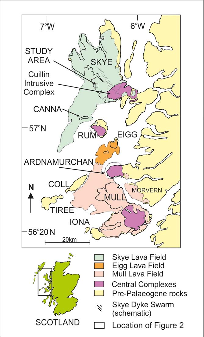
Figure 1 Simplified geological map of the Inner Hebrides, illustrating the distribution of the Skye Lava Field and the location of the map given in Figure 2.
The TF is preserved as two highly distinctive outcrops of a basaltic lava of olivine tholeiite (MORB-like) composition (Thompson et al. Reference Thompson, Esson and Dunham1972; Esson et al. Reference Esson, Dunham and Thompson1975) erupted on top of the predominantly mildly alkaline-transitional Palaeocene SLF (or Skye Lava Group). At present-day levels of erosion, this tholeiitic lava is the youngest known eruptive product of the SLF still preserved and provides an important insight into the architecture, emplacement styles and mechanisms, including multi-tiered columnar joint development, and the stratigraphical development of the lava sequences erupted onto the continental margins of the NE Atlantic prior to the onset of ocean floor spreading at c. 55 Ma.
We present the results of detailed geological mapping and section-logging in the Talisker district of the SLF and discuss aspects of the physical volcanology, syn-volcanic sedimentation, lithofacies architecture and structure of the TF and associated units (Figs 2–6). Geochemical and mineralogical data are briefly summarised where relevant to setting the Formation within the overall context of Palaeocene volcanism on Skye. We conclude that the TF satisfies the criteria for its emplacement as a large-scale intracanyon-style lava and that its eruption followed a significant hiatus in the development of the SLF, during which an active drainage system developed due to localised uplift caused by the formation of a volcanic superstructure, now represented by the Skye Central Complex. This central shield volcano developed on the slightly older (most likely by <1 m.y.) and volumetrically-dominant ‘plateau-building’ phase of the lava field, erupted from fissures now represented by the NW-trending regional dyke swarm.

Figure 2 Geological map of the Preshal More and Preshal Beg area, west central Skye.
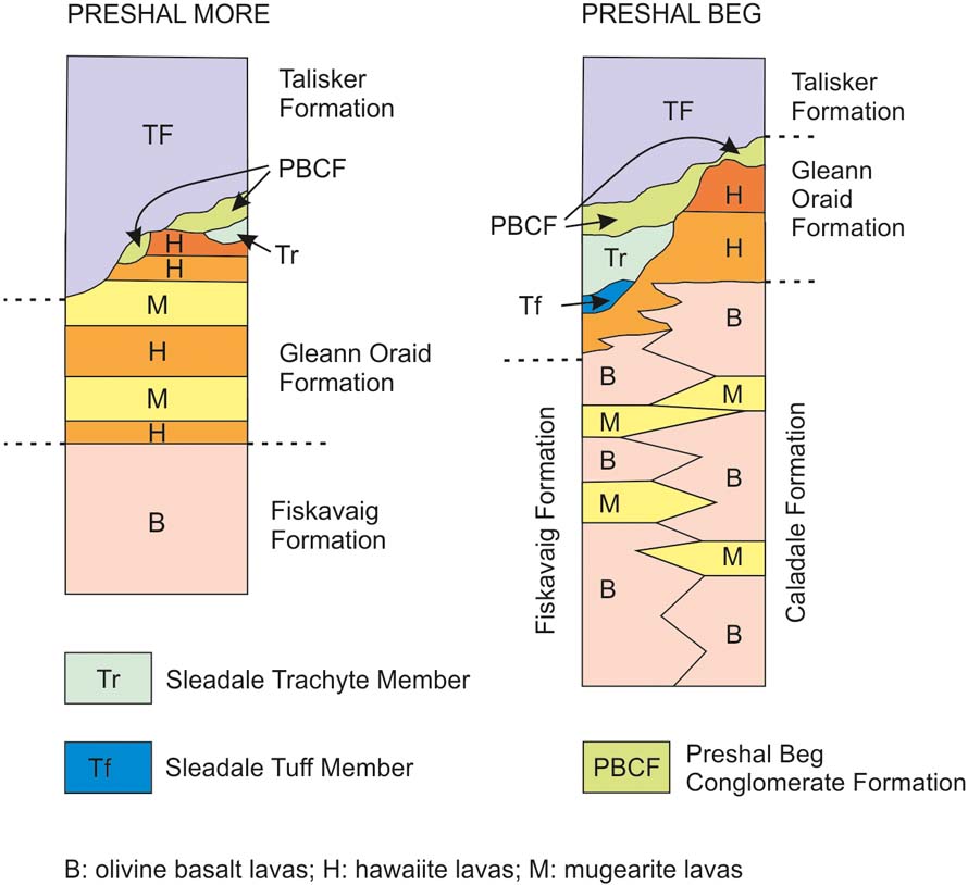
Figure 3 Schematic generalised vertical sections illustrating the relationships between the Talisker Formation (TF) Preshal More and Preshal Beg outcrops, the Preshal Beg Conglomerate Formation (PBCF) and earlier elements of the Skye Lava Field. See main text for details.
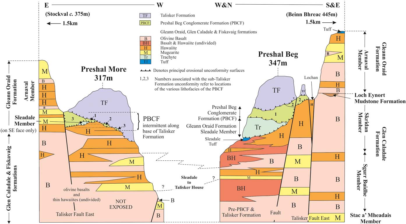
Figure 4 Schematic diagram of facies and contact relationships of the Preshal Beg Conglomerate Formation (PBCF) and the Talisker Formation (TF) lava at Preshal More and Preshal Beg.
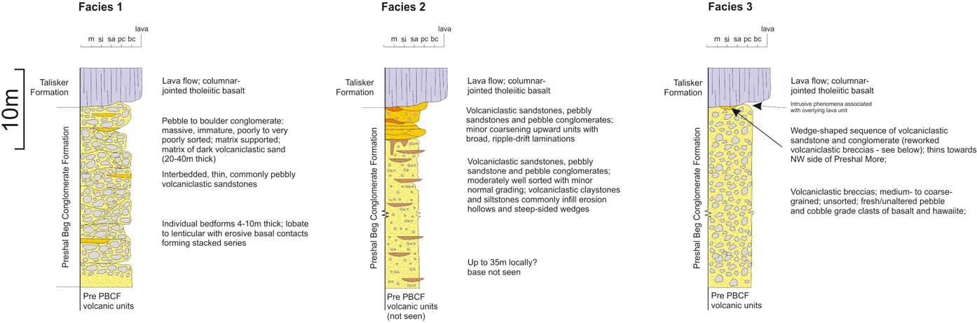
Figure 5 Generalised vertical sections through the three main facies of the Preshal Beg Conglomerate Formation (PBCF), the distribution of which are indicated in Figure 4 and discussed in detail in the main text.
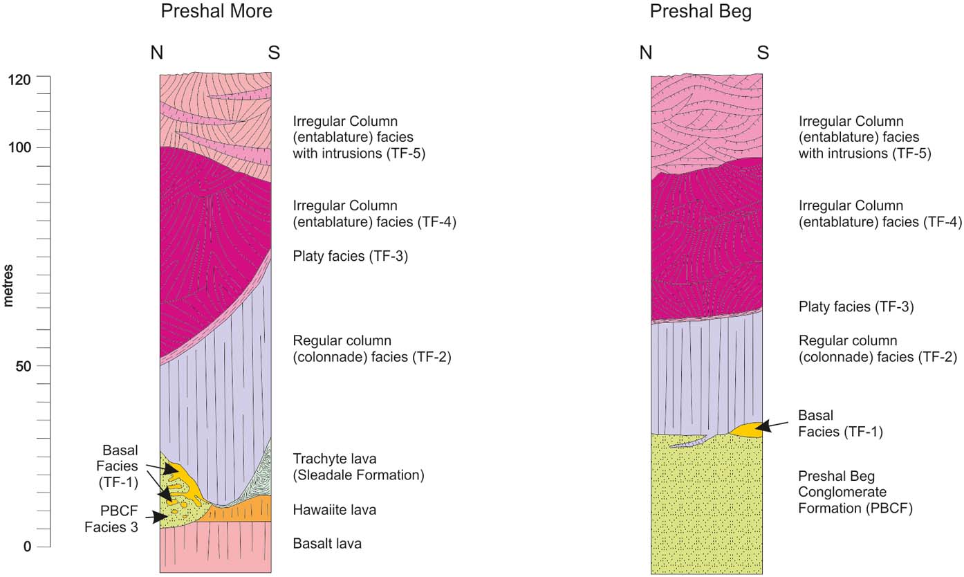
Figure 6 Internal structure of the lava outcrops on Preshal More and Preshal Beg.
We follow the terminology set out by Self et al. (Reference Self, Thordarson, Keszthelyi, Mahoney and Coffin1997, Reference Self, Keszthelyi and Thordarson1998), Kilburn (Reference Kilburn and Sigurdsson2000) and Vye-Brown et al. (Reference Vye-Brown, Self and Barry2013) to describe lavas and lava flow fields. Specifically, a lava or lava flow is an individual unit within a flow field, and a flow field is the product of a single eruptive event. A lava lobe refers to the morphology of a lobe of any size and a sheet lobe is the widest and most tabular part of a lava lobe.
1. Geological setting
The SLF is one of three lava fields in NW Scotland (Skye–Canna–NW Rum; Eigg–Muck–SE Rum; Mull) (Fig. 1) that formed early in the Palaeogene as part of the larger North Atlantic Igneous Province (NAIP). It has an overall synformal or basinal form (Anderson & Dunham Reference Anderson and Dunham1966; England Reference England1994), unconformably overlies a Mesozoic half-graben structure – the so-called Sea of the Hebrides Basin or Little Minch Trough (Binns et al. Reference Binns, Mcquillin and Kenolty1974; Fyfe et al. Reference Fyfe, Long and Evans1993) – and has a cumulative preserved thickness of about 1200 m. The lava field appears to have been constructed as a series of overlapping and regionally interdigitating fissure-fed, large-scale eruptive sequences. These lava ‘groups’ as defined by Anderson & Dunham (Reference Anderson and Dunham1966) and Williamson & Bell (Reference Williamson and Bell1994) or ‘formations’ (BGS 2000) comprise mainly stratiform, subaerial facies lavas; pyroclastic products are comparatively rare (Emeleus & Bell Reference Emeleus and Bell2005). Also interbedded with these volcanic rocks are thin and relatively common, but patchily developed, laterites, palaeosols and rarer fluviatile and lacustrine sedimentary rocks. Some laterites preserve evidence of pyroclastic activity (Bell et al. Reference Bell, Williamson, Head and Jolley1996; Emeleus et al. Reference Emeleus, Allwright, Kerr and Williamson1996). Apart from an initial subaqueous eruption that produced locally-developed hyaloclastite facies, the so-called Palagonite Tuff of Anderson & Dunham (Reference Anderson and Dunham1966), the lavas of the early lava field are mainly mildly alkaline-transitional, subaerial facies basalts and their differentiates. There is a crude cyclicity to much of this early volcanism, as thick, more evolved flows (mainly hawaiite or mugearite) were typically erupted only after a significant hiatus in activity, during which major lateritic surfaces developed on thick sequences made up of numerous, and commonly thinner, basaltic lavas. As a general rule, in both western and central Skye, such evolved flows become increasingly common at stratigraphically higher levels and locally may also include benmoreites and trachytes.
Most of the basaltic lavas within the SLF are simple, tabular, sheet-like bodies and many, if not most, were emplaced as passive inflated pāhoehoe flows. Others have structures more reminiscent of classical a'a types and a few appear to grade laterally from pāhoehoe sheets into a'a-like breccias. The more evolved lavas tend to be considerably thicker and more massive than the basaltic lavas; hawaiites and mugearites are commonly individually traceable over considerable distances (kilometres) and, in some cases, act as reliable marker beds. Detailed field observations have demonstrated that a variety of flow morphologies, volcanic facies and facies associations may be recognised (Williamson & Bell Reference Williamson and Bell1994; Emeleus & Bell Reference Emeleus and Bell2005). Several types of stratigraphical disconformity, such as onlap, individual lava and group truncations, flow-channelling around upstanding ‘kipuka’-like masses, channel overtopping or overbanking and valley-fill phenomena, are present within the sequence. The architecture and volcanic facies of individual lavas, as well as the presence of weathered flow tops, commonly with associated palaeosols, and thin, ephemeral fluviatile or lacustrine sedimentary units, are evidence of a subaerial environment. The development of laterites and palaeobotanical data suggest that the climate was warm-temperate to sub-tropical (Jolley Reference Jolley and Widdowson1997).
The TF is the youngest recognised volcanic unit in the Skye sequence (Williamson & Bell Reference Williamson and Bell1994), the product of one effusive event, and is interpreted as a single flow field. It overlies an erosional unconformity (buried landscape) carved into one of the highest stratigraphical units preserved within the SLF, the Gleann Oraid Formation (Williamson & Bell Reference Williamson and Bell1994; BGS 2000). This formation is a complex assemblage of interdigitating lavas, many of which cannot be traced far beyond the confines of the Talisker area, and consists of two members: a sequence of hawaiite, mugearite and less common basalt lavas – the Arnaval Member – and the Sleadale Member, a trachytic tuff (the Sleadale Tuff) overlain by a thick trachytic lava (Fig. 3) (Williamson & Bell Reference Williamson and Bell1994; BGS 2000). Zeolite assemblages associated with the higher stratigraphical units in northern and west-central Skye suggest that perhaps up to 1400 m of original cover, presumably of later volcanic products, has been eroded since the Eocene (King Reference King1977; S. Miller pers. comm. 2000).
2. Continental flood lava provinces and intracanyon lava flows
Three basic morphological flow-types are widely recognised within continental flood basalt provinces; individual flows may comprise one or more of these. The commonest form is the ubiquitous flat-lying, laterally extensive (subaerial) sheet flow-type that makes up the bulk of most flood basalt terrains. Less widespread is the restricted but locally common invasive flow-type (Byerly & Swanson Reference Byerly and Swanson1978, Reference Byerly and Swanson1987; Anderson & Vogt Reference Anderson and Vogt1987; Wells & Niem Reference Wells and Niem1987; Ross Reference Ross, Reidel and Hooper1989; Rawlings et al. Reference Rawlings, Watkeys and Sweeney1999; Peate et al. Reference Peate, Larsen and Lesher2003). Third, there are the so-called intracanyon flows – a rare, but very special form of valley-fill phenomenon.
The term intracanyon almost certainly originated informally in the Unites States during the early 1930s (P Hooper, pers. comm. 1998) and the formalised title first appeared on early USGS geological maps of Washington State (S Reidel, pers. comm. Reference Reidel1998). Whilst they did not use the term, Thayer (Reference Thayer1936) and Chappell (Reference Chappell1936) described features similar to those which define intracanyon volcanism from the High Cascade Range and the Columbia River Basalt Group (CRBG), respectively. It was clearly an accepted term when used by Bogue & Hodge (Reference Bogue and Hodge1940), became more widely used during the late 1950s and 1960s (e.g. Wilkinson Reference Wilkinson1959; Mackin Reference Mackin1961; Peck et al. Reference Peck, Griggs, Schlicker, Wells and Dole1964; Clem Reference Clem1966; Green Reference Green1968; McKee et al. Reference McKee, Hamblin and Damon1968; Hamblin Reference Hamblin1969), and was increasingly used in studies of the CRBG following the work of Swanson & Wright (Reference Swanson and Wright1975) and Swanson et al. (Reference Swanson, Wright and Clem1975). Williams & McBirney's (Reference Williams and McBirney1979) text on volcanology uses the term without definition, as though it was well-accepted.
In its broadest sense, the term intracanyon continues to be used, and lavas of this type are reported from several disparate volcanic terrains, but only rarely so from continental flood basalt provinces. Examples include: Antarctica (Smellie et al. Reference Smellie, Pankhurst, Hole and Thomson1988, Reference Smellie, Hole and Nell1993); Lanin Volcano, Argentina (Lara et al. Reference Lara, Naranjo and Moreno2004); Puelche Volcanic Field, Chile (Hildreth et al. Reference Hildreth, Fierstein, Godoy, Drake and Singer1999); Gran Canaria (Lietz & Schmincke Reference Lietz and Schmincke1975; Perez-Torrado et al. Reference Perez-Torrado, Carrecado and Mangas1995; Bogaard & Schminke Reference Bognaard, Schmincke, Weaver, Schmincke, Firth and Duffield1998; Guillou et al. Reference Guillou, Torrado, Machin, Carracedo and Gimeno2004; Paris et al. Reference Paris, Guillou, Carracedo and Perez-Torrado2005); Madeira (Weyl Reference Weyl1975; Geldmacher et al. Reference Geldmacher, Boggard, Hoernle and Schmincke2000; Schwarz et al. Reference Schwarz, Klugel and Wohlgemuth-Ueberwasser2004; Burton & MacDonald Reference Burton and MacDonald2008); and Poas Volcano, Costa Rica (Marshall Reference Marshall2000; Rymer et al. Reference Rymer, Cassidy, Locke, Barboza, Barquero, Brenes and Laat2000). Non-flood-basalt volcanism examples from the western USA are: Arizona (Hamblin Reference Hamblin1969, Reference Hamblin1994; Holm & Cloud Reference Holm and Cloud1990; Crow et al. Reference Crow, Karlstrom, Mcintosh, Peters and Dunbar2007); Idaho (Lupher & Warren Reference Lupher and Warren1942; Shervais & Howard Reference Shervais and Howard1975); California (Duffield & Smith Reference Duffield and Smith1978); and Oregon (Brossy Reference Brossy2006; Brossy et al. Reference Brossy, Ely, O'Connor, Fenton, Grant, House and Safran2006; McClaughry & Ferns Reference McClaughry and Ferns2006; McClaughry et al. Reference McClaughry, Ferns and Gordon2009). In general, the latter are characterised by repeated high-effusion rate eruptions of large volume, relatively low viscosity and rapidly emplaced tabular flows; there is little accompanying tectonism and the resulting topography is consequently subdued. Where circumstances allow, however, intracanyon flows may form as lava enters topographical depressions. Commonly, these are simple linear features defined either by the margins and morphology of earlier flows, but they may also be part of an older and much more complex landscape, including deeply incised valleys or gorges (canyons). Newer flows may be channelled effectively down these for some, possibly all, of their length and for some considerable distance. Intracanyon lavas are emplaced either as such far-travelled flows captured by river systems and valleys marginal to or beyond the volcanic field, or as flows within a palaeo-drainage system previously established on the volcanic field. The second scenario may follow a period of uplift, intra-basinal faulting, down-wasting, erosion and sedimentation, coinciding with a significant hiatus in volcanic activity.
In the geological record, intracanyon lavas are distinguished by having abnormally high length-to-width ratios and may form exceptionally thick ribbon-like units or disconnected outliers. Commonly, hiatuses in volcanic activity also allow changes, often subtle, in magma chemistry and many ‘detached’ intracanyon flows may be identified in this way (e.g. Hladky Reference Hladky1998). Some flows have been shown to have been emplaced far, up to hundreds of kilometres, from their source areas (e.g. Snavely et al. Reference Snavely, Macleod and Wagner1973; Beeson et al. Reference Beeson, Perttu and Perttu1979; Wells et al. Reference Wells, Simpson, Bentley, Beeson, Mangan, Wright, Reidel and Hooper1989). The more distal portions of intracanyon flows may pond in deeper topographical lows, hollows and basins, or become impounded against obstructions before solidifying and burial by later flows. Where subsequent erosion removes the ‘country rock envelope’, it can leave an inverted topography whereby the more massive and therefore generally more resistant intracanyon lavas become prominent ridges and hills in the new landscape.
Some of the best documented and spectacular occurrences of intracanyon lavas are the examples found in the CRBG (Mackin Reference Mackin1961; Green & Short Reference Green and Short1971; Snavely et al. Reference Snavely, Macleod and Wagner1973; Waters Reference Waters and Beaulieu1973; Swanson et al. Reference Swanson, Wright and Clem1975; Holden & Hooper Reference Holden and Hooper1976; Vogt Reference Vogt1979, Reference Vogt1981; Reidel Reference Reidel1978a, Reference Reidelb; Beeson et al. Reference Beeson, Perttu and Perttu1979; Swanson et al. Reference Swanson, Anderson, Bentley, Byerly, Camp, Gardner and Wright1979, Reference Swanson, Anderson, Camp, Hooper, Taubeneck and Wright1981; Timm Reference Timm1979; Anderson Reference Anderson1980; Waters et al. Reference Jefferson, Grant, Lewis and Lancaster1981; Hooper et al. Reference Hooper, Kleck, Knowles, Reidel and Thiessen1984; Tolan & Beeson Reference Tolan and Beeson1984; Tolan et al. Reference Tolan, Beeson and Vogt1984a, Reference Tolan, Beeson and Vogtb; Beeson et al. Reference Beeson, Fecht, Reidel and Tolan1985, Reference Beeson, Tolan, Anderson, Reidel and Hooper1989; Anderson & Vogt Reference Anderson and Vogt1987; Bailey Reference Bailey, Reidel and Hooper1989; Ross Reference Ross, Reidel and Hooper1989; Wells et al. Reference Wells, Simpson, Bentley, Beeson, Mangan, Wright, Reidel and Hooper1989; Bishop & Smith Reference Bishop and Smith1990; Bush et al. Reference Bush, Otheberg and Priebe1995; Beeson & Tolan Reference Beeson and Tolan1996; Self et al. Reference Self, Thordarson, Keszthelyi, Walker, Hon, Murphy, Long and Finnemore1996, Reference Self, Thordarson, Keszthelyi, Mahoney and Coffin1997; Hladky Reference Hladky1998). Notable examples include several large flows documented as being between 40 m and 207 m thick and several that have not only inundated palaeo-drainage systems but also travelled many tens of kilometres down ancestral river channels before becoming impounded and ponded. Continental flood basalt province intracanyon-style volcanism has also been described from Iceland (e.g. in the Vatnsdalsfjall area; Auerbach Reference Auerbach2004; McClanahan Reference McClanahan2004), the Quaternary of Spitsbergen (Skjelkvale et al. Reference Skjelkvale, Amundsen, O'Reilly, Griffin and Jelsvik1989) and the Deccan Province, India (Baksi et al. Reference Baksi, Byerly, Chan and Farrar1994; Jay & Widdowson Reference Jay and Widdowson2008).
Of significance to the present study is the lava produced by the 1783 Laki fissure eruption of the sub-glacial Grímsvötn Volcano in southern Iceland, which was channelled for over 25 km down two deeply incised river gorges before spreading out laterally as lava fans or deltas (Thordarson & Self Reference Thordarson and Self1993) some 35 km from the source vents. These gorges, one of which is thought to have had an average pre-eruption depth of 150–160 m and a width of 400–500 m, were totally infilled and even overtopped by the flow. Subsequent differential erosion will, almost certainly, exhume the valley-fill sequences, revealing a classical inverted-topography intracanyon lava. We see the 1783 eruption as offering a good analogue to the TF.
3. Field relationships of the Talisker Formation (TF)
A substantial time interval, of the order of tens to hundreds of thousands of years (Jefferson et al. Reference Jefferson, Grant, Lewis and Lancaster2010), sufficient to develop a well-developed drainage network, separated the eruption of the last Gleann Oraid Formation lavas and the emplacement of the TF (see sections 9 & 10). During this interval, the rest of the lava field in west-central Skye appears to have been volcanically dormant. However, this relative quiescence was accompanied by faulting and significant regional uplift, followed by considerable erosion and down-wasting of the existing SLF. This produced a rugged, sparsely vegetated terrain (Jolley Reference Jolley and Widdowson1997) cut by river gorges, broad valleys and lakes.
There are several lines of evidence for supposing that such features formed during the evolution of the immediately pre-TF landscape and for the existence of a major palaeo-valley system in the Talisker area: (i) the existence of complex unconformable relationships between the early lava field and both the overlying Preshal Beg Conglomerate Formation (PBCF) and the TF (Fig. 3); (ii) the nature and architecture of the lithofacies characterising the PBCF; and (iii) the form and internal structures of the TF.
3.1. Palaeosurfaces and unconformities
A complex unconformity surface separates the TF and units of the underlying PBCF from elements of the earlier lava field of west-central Skye (Figs 3, 4). The stratigraphically highest units below the PBCF (Fig. 3) preserve complex interflow relationships, including local valley-fills, pinch-swell features indicative of flow channelling around topographical obstacles and the marginal overtopping of a localised palaeo-topography, flow terminations and wider-scale onlap and downlap relationships. Thin interflow volcaniclastic units and lateritic palaeosols are commonplace. Locally, the base of the TF directly overlies the Gleann Oraid Formation, but at most locations the PCBF is sandwiched between them and in part represents the partial fill of a pre-existing fault-controlled topographic low, possibly a shallow graben (cf. Holm & Cloud Reference Holm and Cloud1990). This complex sequence of volcanic and sedimentary rocks is now preserved within a narrow, fault-bounded, north-south oriented valley, the Talisker Graben (Figs 2, 4).
3.1.1. North face of Preshal More
Along the north-facing slopes of Preshal More at Buaile an Fharaidh (Fig. 2), the Gleann Oraid Formation is represented by the Arnaval Member, which comprises a sequence of flat-lying massive, sheet flows dominated by hawaiites and mugearites. At the western nose of Preshal More, the TF directly overlies an hawaiitic lava. This lava is one of a series of thin stacked hawaiitic units that overlie a major mugearite lava in this sequence, but which is difficult to correlate directly with lavas in adjacent fault blocks; they are probably at a high stratigraphical level within the Arnaval Member. Eastwards, the base of the TF rises as it oversteps younger hawaiitic and basaltic lavas with locally intervening thin beds and irregular lenticular masses of the PBCF. Towards the Talisker Fault (East) (Fig. 2), along the north-eastern margins of Preshal More, this gentle ramping of the base is accentuated above a thick wedge-shaped body of PBCF breccias.
3.1.2. South face of Preshal More
As along the northern face, the base of the TF is inferred to rise to the east, progressively overstepping units of the Gleann Oraid Formation. Exposures here are, in the main, poor due to an extensive talus of broken lava columns, but towards the south-eastern end of the hill, lithological changes in the units below the TF are indicated by changes in slope morphology. Craggy irregular terracing developed on the Arnaval Member lithologies gives way, laterally and upwards, to short-grass-terraced slopes typical of the trachytic Sleadale Member. Rare, scattered exposures reveal a pinkish-grey-weathering, highly vesicular trachyte lava up to 20 m thick, although neither base nor top may be determined with any precision. The contact between the TF and underlying units of the Gleann Oraid Formation or the PBCF is not seen. Due to extensive (present day) talus cover, there is no evidence for the existence of the PBCF along the entire southern slope of Preshal More; however, as it crops out on the NE slopes of Preshal Beg, it is most likely present.
3.1.3. North face of Preshal Beg
Along the entire northern face of Preshal Beg the irregular base of the TF overlies a thick development of the PBCF (Figs 2, 4, 7a). Overall, the unconformity surface is inclined gently to the NW, although locally the base of the lava appears centroclinal. The base of the PBCF is nowhere exposed, but may be closely approximated in the field as a distinctive grassy slope similar to that noted along the south-eastern side of Preshal More; craggy exposures of trachyte lava confirm the presence of the Sleadale Member directly below and extending across the entire width of the graben (ca. 1 km at this point). The Sleadale Member here comprises a locally developed basal trachytic tuff and a single lava (or flow field) of pale-weathering, highly vesiculated, porphyritic trachyte with a maximum thickness of c. 55 m. To the north, in Sleadale, stratigraphically lower lavas within the Arnaval Member are predominantly hawaiites and thin basalts. Regional mapping of the lava field (Williamson Reference Williamson1979; Williamson & Bell Reference Williamson and Bell1994; BGS 2000) suggests that this development of the Arnaval Member may interdigitate with part of the upper (Skridan) Member of the Glen Caladale Formation (Fig. 4).

Figure 7 (a) Main exposure of facies PBCF-1 on the north side of Preshal Beg at c.[NG 3313 2792], comprising stacked lobate masses of boulder conglomerate, overlain by columnar-jointed Talisker Formation (TF) lava, with approximate locations of (b) (c). (b) Detail illustrating poorly-sorted character of PBCF-1 in exposure at c.[NG 3313 2792]; arrows indicate orientation of stratification, pole c.1 m long. (c) Detail illustrating stratification of PBCF-1 in exposure at c.[NG 3313 2792], arrows indicate orientation of stratification, pole c.1 m long. (d) Typical exposure of facies PBCF-2, comprising moderately well-sorted, bedded volcaniclastic sandstones, pebbly sandstones and pebble conglomerates, on the SE side of the small satellite hill SE of Preshal Beg at c.[NG 3320 2763], arrows indicate orientation of stratification, hammer shaft c.60 cm long; (e) Exposure of facies PBCF-3, comprising medium- to coarse-grained poorly-sorted breccias (B), invaded by sheets of lava (L), brecciated basalt (hyaloclastite, H) with abundant hydrothermal veins and cavity fill, and associated basalt pillows (P), on the north face of Preshal More at c.[NG 3346 3003], ruler is 30 cm long.
3.1.4. South face of Preshal Beg
The distinctive geomorphological featuring produced by the Sleadale Member is readily traceable below the south-western cliffs of Preshal Beg, but appears not to extend far towards the south-eastern margin of the hill. Along much of the southern slopes, field relationships at the base of the TF are, again, obscured below an extensive talus, mirroring the southern slopes of Preshal More. However, viewed from a short distance, the lack of the typical trachyte featuring and the presence of isolated crags of thinner, but still massive, more melanocratic lavas at the equivalent topographical levels makes it amply clear that the Sleadale Formation must thin abruptly (possibly due to channelling or its having a restricted domed form) and is almost certainly absent beneath the south-eastern part of the hill. Consequently, in this sector, the PBCF rests upon a buried topography of mainly hawaiitic lavas belonging to the Arnaval Formation. The base of the overlying TF, although irregular, rises to the SE by as much as 35–40 m and is in contact with various PBCF facies around the hill; locally there are significant ramp structures. This is confirmed by the juxtaposition of exposures of contrasting lithology at progressively higher topographical levels at the south-eastern end of Preshal Beg and also beneath the small (satellite) outlier near the small lochan (Figs 2, 4). The field relationships of these units suggest that there may have been a period of faulting and significant erosion and down-cutting of PBCF lithofacies 1 (see below) prior to emplacement of the TF, and possibly also prior to the deposition of PBCF lithofacies 2 (see below). The later units of this uppermost PBCF facies may, additionally, overstep the other facies and may have buried one of the subsidiary boundary faults to the graben (Fig. 4).
The form of the Sleadale Formation trachyte appears to be that of a laterally restricted, irregular, possibly dome-like, extrusive body. Both the lava and the localised trachytic tuff at its base disconformably overlie a palaeo-topography of subaerially-weathered and eroded differentiated lavas of the Arnaval Member. It appears to have been erupted mainly in proximity to the present-day position of Preshal Beg within the confines of the Talisker Graben (now the Sleadale valley) adjacent to the Talisker Fault (East). A precursor of this larger valley may, therefore, have been present as a fault-controlled structure prior to the eruption of the trachyte magma. The main lines of evidence in support of this architecture include its abrupt change in thickness away from its thickest development and termination along the eastern flanks of the present-day graben and its seeming absence north of Preshal More.
4. The Preshal Beg Conglomerate Formation (PBCF)
Following the emplacement of the Sleadale Member trachyte, eruptive volcanism in west-central Skye waned. In the Talisker area, it appears to have ceased altogether so much so that the existing lava field experienced significant uplift and erosion, together with the establishing of a significant palaeo-topography (in-part fault controlled) and palaeo-drainage system. The continuing development of an incised valley system within the Talisker Graben is reflected in the lithological variations within, and facies architecture of, the PBCF. The formation was erroneously, though understandably because of its overall poorly-sorted, massive, blocky, chaotic and melanocratic appearance, interpreted by previous researchers as (volcanic) agglomerate (e.g. Harker Reference Harker1904). Some units are, indeed, difficult to interpret and may well be immature breccias or conglomerates derived from primary pyroclasts, but the overall depositional regime was undoubtedly sedimentary.
The PBCF is a somewhat disparate suite of interbedded and juxtaposed sedimentary rocks collectively deposited during the period prior to the eruption of the TF. These heterogeneous sedimentary rocks are, therefore, crucial to understanding the palaeoenvironmental setting for the subsequent eruption and emplacement of the TF flow field. Whereas directional sedimentary structures are poorly developed (see below), logically these strata, as their deposition immediately preceded the emplacement of the TF, which has a compositional link to the Cuillin Intrusive Centre (see below), were sourced from the SE to east.
Detailed mapping reveals that there are three main and distinct (litho)facies associations: (i) boulder conglomerate (PBCF-1); (ii) bedded sandstone and conglomerate (PBCF-2); and (iii) medium- and coarse-grained angular breccia (PBCF-3). Associated with these are minor beds and lenses of fine- to medium-grained breccia, sandstone and siltstone, together with reddened siltstone and mudstone and associated palaeo-surfaces. These are described along with the major facies to which they are principally associated.
4.1. Boulder conglomerate (facies PBCF-1)
This facies is the most common and reaches its maximum development of between 20 m and 40 m on the north face of Preshal Beg (Figs 5, 7a) (Williamson & Bell Reference Williamson and Bell1994, fig. 25); minor exposures, slope morphology and a distinctive vegetational change indicate its presence on the western- and southern-facing slopes of the hill. It is also present in lenticular exposures beneath the TF along parts of the northern flank of Preshal More. PBCF-1 comprises a thick but internally variable sequence of massive, immature, poorly- to very poorly-sorted, mostly clast supported, pebble- to boulder-grade conglomerates with a variable matrix of dark lithic-volcanic sand, silt and clay, and some rare interbedded thin, commonly pebbly, sandstones. It is almost wholly volcaniclastic, with little siliciclastic content (rare quartz, alkali feldspar).
These conglomerates form an overlapping series of stacked, lenticular bedforms, individually up to 10 m thick but generally less than 4 m thick. Clasts within the conglomerates range from less than 1 cm across to tabular blocks over 2×0.45 m, are sub-rounded to angular (exfoliation gives a false impression of roundness and sphericity) and appear to be derived exclusively from locally available volcanic rocks comprising various basalts, hawaiites and mugearites and their scoriaceous and amygdaloidal variants. There are also rare clasts of basaltic tuff, reddened pebble conglomerate and indurated laterite. Clasts of trachyte are absent from PBCF-1 facies exposures at Preshal Beg, despite the Sleadale Member being the immediately underlying unit (Fig. 2); however, lower PBCF beds and the contact between these and the trachyte are not seen and so their total absence from the Formation must remain speculative. A few small angular clasts of trachyte were however located in the PBCF at Preshal More. Also absent from the clast assemblage in this facies and, indeed, throughout the rest of the Formation, are clasts of epiclastic origin i.e. the pre-Palaeogene rocks and coarse-grained intrusive suites (cf. the Minginish Conglomerate Formation in the older part of the lava field to the south: Williamson & Bell Reference Williamson and Bell1994). Sedimentary structures are not common and the facies is rather more typified by its chaotic, unpredictable variations both in vertical and lateral sections. A weak sub-horizontal to moderately-inclined fabric may be present in some places and, whereas there are hints of clast imbrication locally, these are ambiguous and contradictory. Locally, some of the larger conglomerate lenticular bedforms appear to be crudely, but irregularly, massively- to thickly-bedded. Individual smaller bedforms may be planar or lenticular. Most appear wholly unsorted, but a few display either a crude reverse- or, more commonly, a normally-graded profile. Thin, irregular, wavy, highly-inclined (>60°) rootless zones of relatively finer-grained conglomerate (with a sand grade matrix) appear to locally cut through one or more of these lenticular bedforms. Some zones preserve a crude vertical, clast- and grain-size foliation with an irregular central sand-rich portion containing clay-filled vesicle-like structures. Little is seen of facies PBCF-1 on the satellite outlier immediately east of the main hill of Preshal Beg and detailed mapping here suggests that it may be much reduced in thickness on the northern side of this minor hill and possibly entirely absent from the southern side, where only facies PBCF-2 appears sandwiched between the TF and the massive hawaiites of the Arnaval Formation (Figs 2, 4).
Discontinuous exposures of lithofacies PBCF-1 occur along the north-facing slopes of Preshal More and are best developed towards the east (at Grid Reference [NG 33425 30062]; Figs 2, 4). The sequence, locally up to 6 m thick, comprises two distinct beds with horizontal bounding surfaces. The lower bed, 0.5–1.5 m thick, is of poorly-sorted breccia and conglomerate, with abundant rounded pebble and cobble grade clasts. It is overlain by 3.5–4 m of upward-fining boulder conglomerate, with clasts up to c. 0.5×0.25 m. Intimately associated with these conglomerates, mostly as small sedimentary drapes, are thin (2–3 cm thick) beds of lithofacies PBCF-2. Another characteristic of the facies is the presence, mostly between bedforms, of numerous cuspate slip-surfaces and shear-planes, many at a high angle (>45°) and with slickensides; these may be accompanied by thin developments of breccia attributed to PBCF-3.
4.1.1. Interpretation
This lithofacies has all the hallmarks of coarse-grained, perhaps concentrated, debris flows. These may have been generated from either a series of proximal alluvial fans or lahars.
Whilst there are some rare and highly localised and minor interbedded facies as described above, which perhaps indicate pulsed or intermittent deposition, these coarse and chaotic conglomerates were most likely emplaced extremely rapidly as remobilised, unconsolidated volcanic material, in-part probably fluvially derived (?flash-flooding), within a confined and certainly restricted depression, perhaps fault-bounded river valley or gorge on the lava field (cf. Holm & Cloud Reference Holm and Cloud1990). Whilst the majority of the clasts are sub- to reasonably well-rounded, this need not indicate a fluvial origin as basaltic rocks are prone to exfoliation and this would be accentuated especially under the type of climatic conditions that are thought to have prevailed during the Palaeocene. Though we cannot entirely rule out an element of fluvial deposition, any primary fluvial input was probably small. The thoroughly chaotic nature, lack of any major sorting and the apparent lack of clasts of the immediately preceding Sleadale trachyte lava, coupled with the rare presence of highly inclined diffuse zones of finer-grained sediment that may be regarded as fluid escape structures, suggest that the debris flows abruptly deposited their sediment load either as they met obstructions on the floor of the valley, or as gradients decreased and the channel flattened out. The dominance of basaltic clasts over more evolved rock-types, and especially the near absence of trachytic clasts both within the facies and in the sub-formational regolith, despite this being the immediately subjacent lava lithology, suggest that the bulk of the facies was actually sourced from parts of the lava field, most likely outside, but possibly also marginally flanking, the immediate Talisker area. The nature and architectures of both the PBCF and the TF imply an overall source area for the former, mainly to the south to SE of the present outcrops.
The presence of the slip surfaces is taken as evidence for post-depositional adjustment and limited mass movement, although some may have been induced by loading during emplacement of subsequent deposits or the overlying TF lava. In addition to alluvial fan debris flow deposits, we suggest that some of these physical and sedimentological features also point to possible similarities with the channel facies and run-out of massive, cohesive, clay-poor volcanic debris avalanche processes (lahars) and channel-fill deposition from the debris flow phases associated with them (e.g. Smith Reference Smith1986; Arguden & Rodolfo Reference Arguden and Rodolfo1990; Glicken Reference Glicken, Smith and Fisher1991; Rodolfo & Arguden Reference Rodolfo, Arguden, Fisher and Smith1991; Smith & Lowe Reference Smith, Lowe, Fisher and Smith1991; Capra & Macias Reference Capra and Macias2000; Vallance Reference Vallance and Sigurdsson2000). Cohesive debris flows commonly ‘freeze’ where palaeoslopes drop to below 0.5–1.0° (Capra & Macias Reference Capra and Macias2000). These mass flow deposits at Talisker, although requiring only low-angled palaeoslopes in order to travel many kilometres from source, could have originated as slope failures on the flanks of a volcanic edifice, possibly an early Cuillin Volcano (see below). However, Reubi et al. (Reference Reubi, Ross and White2005), in documenting a series of larger-scale debris avalanche deposits that formed during uplift associated with large igneous province magmatism, also suggest that avalanches can be triggered by dyke intrusion without a major volcanic edifice being produced. For PBCF-1, the initiating mechanism might therefore have been surface volcanic, shallow intrusive or seismic activity, but may also conceivably have been due to, and accentuated by, periodically exceptional rainfall producing flash flooding from upland areas of deep weathering and wasting (see also Brown et al. Reference Brown, Halohan and Bell2009).
The architectures and topographical dispositions of the PBCF-1 deposits are complex. Whereas it is clear that some units, especially those seen associated with the small outlier east of Preshal Beg, are older than the main development of PBCF-2 facies (see below), there is a possibility that others are, in fact, some of the youngest sedimentary events. This could be the case for those PBCF-1 units observed at the western end of Preshal Beg (Fig. 4). Here, not only are they the lowest topographically, but they are overlain by a thin development of a pillow-breccia facies at the base of the TF (Fig. 8a). These PBCF-1 conglomerates may have been deposited within a fresh erosional channel incised within pre-existing deposits immediately prior to emplacement of the TF lava.
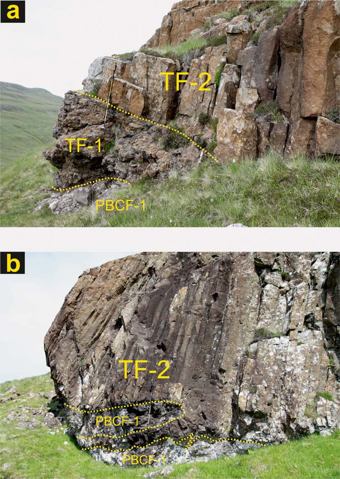
Figure 8 (a) Basal facies (TF-1) of the Preshal Beg lava outcrop, comprising a thin interval of pillow lava, overlying facies PBCF-1 conglomerates and breccias, giving way, upward, to the regular columnar facies (TF-2), on the west side of Preshal Beg at c.[NG 3261 2797]. (b) Sill-like protrusion of basalt (TF-2) into underlying facies PBCF-1 conglomerates on the west side of Preshal Beg at c.[NG 3260 2799].
4.2. Bedded sandstone and conglomerate (facies PBCF-2)
Facies PBCF-2 is best developed and reaches its maximum directly observed thickness of c. 15 m around the small satellite outlier of lava east of the main mass of Preshal Beg (Figs 2, 4, 7d). The true maximum thickness, based upon detailed mapping and a consideration of height differences along the south of the main hill, may be considerably more. Facies PBCF-2 appears to be topographically the highest, and consequently most likely overlies, or is at least younger than, the main development of lithofacies PBCF-1. Elsewhere on Preshal Beg, at lower topographical levels, it is absent and the TF lava directly overlies facies PBCF-1. Along the north face of Preshal More there are a few thin, discontinuous beds of probable facies PBCF-2.
Lithologically, as seen on Preshal Beg, the facies is wholly volcaniclastic and comprises a thin- to medium-bedded sequence of moderately well-sorted sandstones, pebbly sandstones and pebble conglomerates (Figs 5, 7b). Clasts range from less than 1 cm, to over 20 cm, but most fall within the range 2–10 cm. Clasts and matrix alike are locally derived lava types, many of them reddened due to subaerial exposure prior to burial, and laterites; most are sub-rounded to rounded. Unlike the drab, dark grey coloration typifying lithofacies PBCF-1, these rocks are usually pale-weathering in hues of pink and pinkish-grey. Stratification is clear but imperfect; most beds are flat-lying and many pass laterally into either finer- or coarser-grained units. Some of the beds, however, exhibit a small degree of normal (fining-upwards) grading and are crudely cross-stratified in broad trough-shaped bedforms. Less commonly, other thin beds, especially those towards the top of the deposit, exhibit minor coarsening-upward motifs and broad, ripple-drift, cross laminations. There is an overall post-depositional reddening motif to PBCF-2, most prevalent towards the upper parts of the deposits.
There are minor developments of other lithofacies intimately associated with PBCF-2. Fine-grained breccia, sandstone and siltstone locally form thin (a few centimetres) lenticular beds of no great lateral extent within the main body of PBCF-2. The finer-grained lithologies are coarsely- to finely-laminated, and, in places, very irregular and discontinuous ‘drifts’ of granule to sand grade material are present. Colours vary from pinkish-grey and brown through to dark grey and some thin beds may contain finely comminuted carbonaceous fragments. Also present are minor beds of reddened siltstone and mudstone and associated reddened surfaces. Some beds are considerably indurated, with a localised development of secondary carbonate and iron-oxide cements. Others have irregular, possibly erosional, undulating upper surfaces with, in places, thin drapes of intensely reddish brown silty mudstone and clayey siltstone. These drapes are generally only a few millimetres thick and laterally impersistent. Similar undulose surfaces and some accompanying reddened mudstones are locally, but rarely, present between some beds within facies PBCF-1, also on Preshal Beg. It is these relatively clay-rich beds that commonly display evidence of post-depositional instability and slippage.
4.2.1. Interpretation
The considerably finer grain-size, relative paucity of clay and grey basaltic lithic fragments within the predominantly silty matrix, and the more mature and sorted nature of these sedimentary rocks in comparison to those of lithofacies PBCF-1, suggest that they underwent a considerably greater degree of reworking and transportation in a lower energy subaqueous environment. This is most likely to have been fluvial reworking of the alluvial fans, debris cones, debris flows and hinterland regolith established nearby, into a shallow fluvial-lacustrine complex developed on top of, or impounded between, earlier debris flows, possibly through a system of minor overlapping delta-like lobes. The more localised and minor fine-grained breccia, sandstone and siltstone facies is reminiscent of fine-grained clastic material and organic debris commonly but intermittently washed into shallow lacustrine environments during periods of otherwise low discharge. Seasonal rainwash runoff may have been an important contributory mechanism. The minor beds of reddened siltstone and mudstone and associated reddened surfaces are interpreted as incipient palaeosols and subaerially-weathered surfaces. Although volumetrically insignificant within the PBCF as a whole, they are nevertheless important, as their presence indicates both intermittent flooding and shifting patterns in the local Palaeocene groundwater table, with the occasional drying out of the water courses associated with facies PBCF-2 and intense periods of subaerial weathering. They are, therefore, analogous to the prominent boles (lateritic palaeosols) associated with subaerial weathering of the lavas.
The intimate association with some units of the underlying PCBF-1 facies deposits might also suggest that initially some PBCF-2 units were deposited as the distal run-out or stream-flow facies of later lahar-like bodies that did not, themselves, reach as far as the Talisker area. As the waning phases of debris flows are often more dilute and may erode into the earlier parts of the flow, it is possible that PBCF-1 and PBCF-2 therefore could have formed in a single major event, with stream-flow replacing debris-flow. The presence of localised developments of medium-grained breccias facies and the overall reddening of the deposit indicate the effects of contemporaneous palaeo-water tables and periodic drying out or lobe-switching and exposure of the depositional surface to the atmosphere.
4.3. Medium- and coarse-grained angular breccia (facies PBCF-3)
Medium- and coarse-grained breccias comprising basalt and hawaiite clasts are best displayed along the NE flank of Preshal More (Figs 4, 7e). Here, the main development has a distinct wedge-shaped geometry, thickest c. 25 m east of the Talisker Fault (East) (Figs 2, 4), and thinning out to the west; there are no exposures on the southeast flank of the hill, the contact zone being obscured by thick talus, soil and vegetation. Its thickness tends to be somewhat exaggerated as it is intruded/invaded by irregular bodies of both basal massive and partially brecciated facies of the overlying TF lava. It appears to be entirely unbedded, clast-supported and unsorted, with clasts mainly, but not exclusively, of large pebble and cobble grade. In comparison with similar clast lithologies in facies PBCF-1, the clasts are angular to sub-angular and commonly surprisingly fresh, with few signs of either weathering or having been transported far from their source. Locally within this unit, and increasingly more common towards the base, especially at its western termination, there are minor, thin lenticular bodies of conglomerate similar to facies PBCF-1. Some crudely stratified breccias that may simply be locally reworked facies PCBF-3 breccias, occur as lenticular bodies along the base of the TF to the NW. At the NW nose of Preshal Beg (Fig. 4), another thin, but highly localised unit of a similar but finer-grained breccia facies overlies facies PBCF-1 conglomerates. It, too, has been intruded by apophyses of the overlying lava.
Along the northern flank of Preshal More immediately below the base of the TF lava and always intimately associated with facies PBCF-2 and PBCF-3, there are intermittent lenticular bodies, up to 0.75 m thick, of massive medium-grained breccia. These are mainly composed of poorly-sorted sub-angular to sub-rounded clasts of partially decomposed massive aphyric and amygdaloidal basalt, hawaiite and laterite, although there are also uncommon angular clasts of chilled vesicular rock showing only minor zeolitisation. This mixed clast assemblage sets them apart from the monolithic basal flow facies breccias of the TF. Some units are locally mineralised (principally by calcite-chabazite assemblages (Williamson Reference Williamson1979) and some minor sulfide mineralisation) and invaded by chilled tongues of the basal breccia facies of the overlying lava.
4.3.1. Interpretation
The wedge-like architecture of the main development of this facies association, the abundance of presumed very near-to-source clasts within it and its overall positioning relative to the Talisker Fault (East) (Figs 2, 4), suggest that these rocks mainly represent part of a fossil talus apron that was unconsolidated at the time of the eruption of the TF flow field. The marginal valley floor of the graben at this point appears also to have been subjected to periodic flash flooding, with the resultant deposition of some debris flow conglomerates and, whilst similar coarse and angular clast assemblages are reminiscent of some bedforms in some Gilbert-delta type systems (e.g. Breda et al. Reference Breda, Mellere and Massari2007), the lack of associated deposits and the positioning of the unit do not support such an interpretation here. This talus fan developed along the base of an escarpment that was most likely one of the boundary walls of the palaeo-valley into which the TF lava ultimately flowed and became impounded. This feature may have been fault-controlled, the fault perhaps being an earlier version of the Talisker Fault (East). Such a conclusion is circumstantially supported by the angular, very immature nature of the clasts and the intrusive/invasive phenomena associated with the base of the TF lava (see following sections). The minor facies breccias are most likely also of sedimentary origin, but show little evidence of having travelled far from source. The composition and nature of the clast assemblage suggests that they could be interpreted as a very localised reworking of subjacent facies, especially the main talus facies PBCF-3, i.e. they were possibly sourced, at least in part, from some talus breccias, but also with some input from the erosion and fluvial or rainwash redistribution of relatively young flow-front breccias in the volcanic hinterland. In an association similar to that of the PBCF, basalt breccias interpreted as being fossil talus have been reported, along with debris-flow conglomerate deposits, in fault margin settings from the Lower Jurassic of the Fundy Basin, Nova Scotia by Tanner & Hubert (Reference Tanner and Hubert1991).
5. The Talisker Formation (TF) lavas
5.1. Architecture and internal structure
Some of the most compelling field-based evidence pointing to an intracanyon-style emplacement mechanism for the TF lava stems from our detailed study of flow morphology. The thickness, internal structure and overall architecture of the lava contrasts markedly with the more regular, relatively thin and extensive sheet-forms of the lavas forming the bulk of the underlying Gleann Oraid and Glen Caladale formations flooring the Talisker Graben and the surrounding terrain (Fig. 4).
Other than its unusually great thickness, perhaps the most prominent feature of the TF lava is that both outliers preserve spectacularly well-developed suites of columnar joints, comparable in many respects to the grandeur of other better known and classical examples from the NAIP, e.g. Giant's Causeway, Co. Antrim and Fingal's Cave on the island of Staffa, Mull (Williamson & Bell Reference Williamson and Bell2012; see also below). The original top of the TF lava is not, however, preserved, having been removed through erosion. The thickest development of the formation is on Preshal More, where c. 120 m is preserved. The Preshal Beg outcrop is a little thinner, c. 100 m, but its topmost exposures may preserve features that originated closer to the original flow top than those on Preshal More. Such thick lavas are relatively uncommon within the NAIP lava fields, suggesting something special about their environment and mode of emplacement. Other than where more differentiated or evolved flows have formed as lava domes, thicknesses of this magnitude may be attributed most readily to either ponding effects and/or to volumetrically huge eruptions and high effusion rates.
Gross morphology, in particular the overall joint patterns that have developed in both the TF outcrops, make it possible to subdivide the lava into a number of separate structural ‘facies’ (Fig. 6). From base to top these are: (i) basal facies (TF-1); (ii) regular columnar facies (colonnade) (TF-2); (iii) platy facies (TF-3); (iv) irregular columnar facies (entablature) (which may be multiple) (TF-4); and (v) intrusive/sheeted facies (TF-5).
The architecture of these ‘joint facies’ is such that the TF lava would be classified as a Type III flow in the scheme developed by Long & Wood (Reference Long and Wood1986, Reference Long and Wood1987) for characterising lavas within the CRBG. This flow type is typically 30–80 m thick and has a single colonnade-entablature pair with a sharp mutual contact, and with no evidence for the previous existence of an upper colonnade.
The five ‘facies’ of the TF lava are considered in turn, starting with the lowest (basal facies).
5.2. Basal facies (TF-1) and relationships to the pre-Talisker Formation units
The TF lava has complex relationships with earlier formations. Schematic cross-sections illustrating the nature and inter-relationships of the various facies of both outcrops and the subjacent Preshal Beg Conglomerate Formation (PBCF) and Gleann Oraid Formation are presented in Figures 3 and 6. The landscape and environment at the time of the eruption of the TF flow field is summarised in succeeding sections.
TF-1 forms the lowest 0.5–5 m of both outcrops and exists in two, locally intermingled, forms: an irregular body of breccia, composed wholly of volcanic material and commonly associated with fractured, but otherwise intact, globe-shaped pillow-like masses of basalt; or as massive lava up to 1.5 m thick, with crude, irregular joint patterns and a chilled lobate base (Fig. 8). In both instances, the lava is a fine-grained to glassy (hypohyaline) melanocratic rock, with only rare small and widely distributed amygdales. This facies is particularly well-developed on the west and south-west sides of Preshal Beg, where a thin development (c. 1.75 m) of breccia overlies the PBCF (lithofacies PBCF-1; Fig. 8a). These breccias comprise clasts of basalt up to small pebble size and discrete, semi-intact but shattered, lobate-margined and globe-like masses of basalt in a very fine-grained to glassy and rarely fragmental matrix. The junction with the underlying formation is irregular and generally sharp. There is a sharp planar contact between breccia and the overlying flow-laminated, massive, chilled lava (see also below).
Locally, along the base of the lava, for example on the north side of Preshal More, the basal facies comprises either very fine-grained to glassy lobate (some pillow-like, others more akin to pāhoehoe lobes) coherent masses of basalt with crude radial joint patterns, or a breccia of angular fragments of basalt cemented in a zeolite and carbonate matrix with rare pillow-like breccia masses. This is best developed within the NE quadrant of the Preshal More outcrop, where the basal facies appears to have auto-brecciated (Fig. 7e). This is thought to have occurred during the flow's overriding of, and shallow intrusion into, wet (connate-water rich, or shallow water bodies) poorly- or un-lithified sediments of the subjacent PBCF (lithofacies PBCF-3). Irregularly lobate and locally megapillow-like bodies, or large-scale pāhoehoe-like tongues up to several metres across, are common within parts of the PBCF-3 outcrop wedge. Similar and related intrusive phenomena occur at a number of localities on both outliers, with the flow base(es) intrusive into the PBCF in the form of sill-like apophyses, with obvious chilled and locally brecciated margins (Fig. 8b). Similar phenomena have been described by Carr & Jones (Reference Carr and Jones2001) within the basal facies of Permian lavas from the Sydney Basin (Australia); this supports the contention that the TF lava locally intruded into semi-consolidated breccias and likely contemporaneous pyroclastic deposits. In places, the matrix of these breccias may also comprise fine, laminated, pale-coloured (bleached) ‘basaltic sand’ against which the clasts, many of them ragged in form, have quenched. This is highly suggestive of developing peperitic textures. Here, again, the contact relationships indicate that the various deposits of the PBCF were essentially unlithified and still wet when the TF lava was erupted.
Also present within the more massive variant of the basal lava facies is a well-developed, fine, sub-horizontal flow lamination, as, for example, at SW Preshal Beg. This part of the lava displays prominent flow banding in its lowermost 0.5 m and incorporates rare small xenoliths of amygdaloidal basalt. The banding is inclined, at angles of up to 65°, and the attitude of small folds and cross-lamination structures within this zone suggests a localised basal flow direction towards WNW. On the western nose of Preshal More, where massive columnar-jointed lava directly overlies eroded hawaiites of the Gleann Oraid Formation, a similar banding is present within TF-1. These features reflect laminar flow planes, grain-size and modal variations (Williamson Reference Williamson1979) and density contrasts developed at the base of the flow; some may be small pāhoehoe lobes. There is no accompanying platy jointing developed along the base of either outcrop, as for example exemplified by the basal zone of thick CRBG flows described by Self et al. (Reference Self, Thordarson, Keszthelyi, Mahoney and Coffin1997) and Thordarson & Self (Reference Thordarson and Self1998).
Evidence of topographic relief (palaeo-morphology) on the already sloping Palaeocene valley floors, by up to 20 m, but more commonly in step-wise increments of 5 m or less, is indicated by abrupt changes in the structural height of the bases of the two outcrops. The overall pre-TF basal surface under both outliers is inclined to the NW, but there is evidence from both outliers that the lava was, in places, restricted by vertical walls along the northern flanks of both outcrops. Where such ramp-like irregularities in the flow base are present, there are detached masses of basalt, in the form of pillow- and tube-like structures, which developed within intensely brecciated rock composed of lava and PBCF lithologies.
The invasive nature of low viscosity basaltic flows as they encounter unconsolidated and often water-saturated (‘wet’) sediments, is a major feature described from several flows of the CRBG (Mackin Reference Mackin1961; Byerly & Swanson Reference Byerly and Swanson1978, Reference Byerly and Swanson1987; Wells & Niem Reference Wells and Niem1987; Ross Reference Ross, Reidel and Hooper1989). There, not only are there localised intrusive phenomena similar to, but also an order of magnitude greater than, that seen in association with the TF lava, but many of the associated, but now physically detached sills, are located many kilometres ‘down valley’ from the terminations of the subaerial flow-facies themselves. Invasive facies lavas with peperitic-textured margins have also been reported from the Karoo flood basalt province in South Africa (Rawlings et al. Reference Rawlings, Watkeys and Sweeney1999).
5.2.1. Interpretation
The brecciated lithologies described above reflect rapid quenching and violent rupturing of the highly fluid basaltic magma. This occurred both on top of, and locally intrusive (invasive) into, water-saturated and poorly-lithified sediments (cf. CRBG, e.g. Bailey Reference Bailey, Reidel and Hooper1989), or locally into discrete shallow water bodies during its emplacement. The more discrete and massive to less-well brecciated bodies noted on the NE flank of Preshal More within facies PCBF-3, represent either large-scale pillows (cf. the mega pillows of Bartrum (Reference Bartrum1930) and Walker (Reference Walker1992)) or sections through invasive pāhoehoe tongues and compound lava lobes (e.g. Self et al. Reference Self, Thordarson, Keszthelyi, Mahoney and Coffin1997; Thordarson & Self Reference Thordarson and Self1998) originating at the base of the flow. Where contemporaneous sediments or palaeosols appear to be absent, the more massive, but flow laminated, basal sub-facies is usually developed, implying that locally the lava was emplaced in a more passive fashion.
5.3. Regular Columnar facies (TF-2)
This facies is represented by the lower, c. 35–50 m-thick, well-jointed portion of both outcrops. It is essentially, compact, fine-grained, non-amygdaloidal rock, with spectacularly well developed, regular, upright, and most typically hexagonal, columns (Figs 6, 9, 10). It represents between a half and a third of the preserved flow thickness and constitutes the so-called lower colonnade of the threefold division outlined by Tomkieff (Reference Tomkieff1940) and Spry (Reference Spry1962). Its proportion relative to the overlying irregular facies (entablature) may be significantly reduced locally, as on the NE flank of Preshal More.
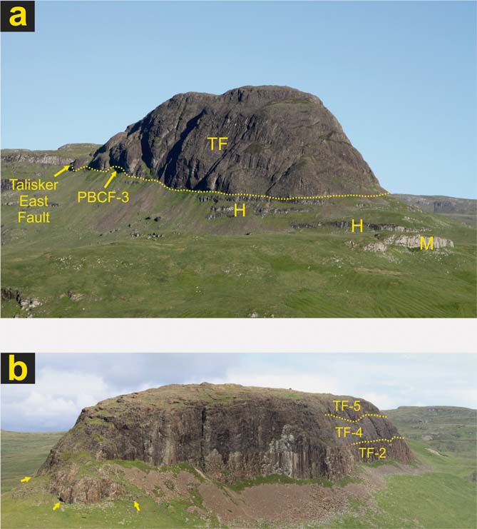
Figure 9 (a) Preshal More, from A' Chailleach on the north side of Gleann Oraid, looking towards the south. Immediately below the crags of lava that form Preshal More (base indicated by dotted line) is the Preshal Beg Conglomerate Formation (facies PBCF-3) (mainly in shadow, arrowed). The terraces on the hillside below (north of) Preshal More are formed of intercalated flows of hawaiite (H) and mugearite (M) of the Arnaval Member of the Gleann Oraid Formation. The Talisker East Fault (arrowed) juxtaposes the Preshal More outcrop of the TF lava and PBCF-3 with lavas of the Arnaval Member on the eastern flank of Preshal More. Height difference between base of flow and summit is c.120m. (b) Preshal Beg, looking towards the NE. The PBCF is poorly exposed on this side of the hill, other than where indicated (arrowed: facies PBCF-1). Localised pillow-dominated facies (TF-1, not indicated) give way upwards to the well-developed regular columns (colonnade) of TF-2, in turn overlain (with a sharp interface) by the irregular columns (entablature) of TF-4, capped by the intrusive/sheeted facies (TF-5). Boundaries on the SE side of Preshal Beg indicated by dotted lines. Height difference between base of lava and summit is c.100 m.
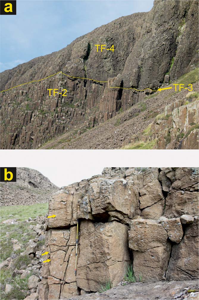
Figure 10 (a) The sharp boundary (dotted line) between the regular columns (colonnade) of TF-2 and the irregular columns (entablature) of TF-4 on the central part of the south side of Preshal More. A thin layer of platy facies, TF-3, intervenes and is typically <1 m thick. (b) Exposure of platy facies (TF-3) (arrowed) at c. [NG 3302 2778] on the east side of the main outcrop of Preshal Beg. Pole is c.1 m long.
The individual columns are typically of constant width (30 cm to 1 m) throughout their height, although a thin upper tier or subzone of relatively (slightly) narrower columns is locally present on Preshal More. Generally, the columns are upright and close to vertical in aspect, but locally their lowermost portions (between 1 m and 4 m) are significantly curved (outwards) and may even be abruptly upturned, with the basal polygonal surface inwardly inclined at up to 50° at the normal flow base. At scattered localities on both outliers, the long axes of the columns have much lower ‘splayed-outward’ inclinations and may, in a few instances, even approach being horizontal. In cross-section, the columns present a variety of polygons. Hexagons are the most common, although both 5- and 4-sided columns are also noted. No statistical analysis has been carried out. Within the main body of this facies, the rock may have a crude fissile appearance and there is commonly a diffuse grain-size and textural banding present (see also sections below), varying in thickness from the scale of a few millimetres to centimetres. This appears to coincide with the presence of orthogonal joint-sets perpendicular to, and dividing the columns along, their length. These so-called chisel structures (Iddings Reference Iddings1886; James Reference James1920), striae (Ryan & Sammis Reference Ryan and Sammis1978) or plumose structures (DeGraff & Aydin Reference DeGraff and Aydin1987) are typically spaced along the columns several to tens of centimetres apart.
5.3.1. Interpretation
The size and regular form of these columnar joints are attributed to the development of contraction joint systems during cooling of the flow under slow, uninterrupted and static conditions, with the substrate, basal and overlying irregular columnar facies acting as effective insulators. Other aspects, including the implications of divergent forms and joint orientations, are considered more fully below.
5.3.2. Inclination of joint systems of the basal and regular columnar facies – implications
Columnar joints in igneous bodies are widely held as having propagated progressively away from primary cooling surfaces and perpendicular to subsequent isothermal surfaces. The orientation of columns is, therefore, a good guide as to the orientation of a flow's bounding surfaces and the long-term cooling history.
The orientation of the columnar joint sets at the base of the regular columnar facies is quite variable. Along the northern flanks of Preshal More, columns with very low dips (0–10°) occur close to the margin of the lava near its base and pass upwards into near-vertical columns. At one locality on the north side of Preshal Beg, similar sub-horizontal to horizontal columns occur at a higher structural level, apparently ‘sandwiched’ between zones of more steeply-inclined columns. The presence of abrupt variations such as this on the faces of both outliers probably indicates that the TF flow encountered near-vertical valley walls (now eroded) during its emplacement and lying perpendicular to the graben. Two explanations are possible. They may be evidence for the former proximity of the flow termination points and so would support an interpretation involving two, possibly subparallel, palaeovalleys and flow emplacement as two separate (but essentially coeval) lava streams. Alternatively, they may simply reflect the presence of irregularities, such as overhangs, steps or local channels systems trending approximately E–W in floors of these pre-TF valleys. The return to vertical columnar joints at higher structural levels on both outliers would suggest that these irregularities were overtopped by the individual lava streams.
Columnar joint sets have been noted in fossil lava lakes. For example, similar structures in a thick (c. 125 m) flow associated with the late-Cretaceous Mount Arod volcano in Southern Israel, was one of the lines of evidence which led Eyal et al. (Reference Eyal, Becker and Samoylov1996) to interpret that particular flow as a crater-filling lava lake. The presence of the underlying PBCF, the absence of extrusive and pyroclastic rim rocks and the nature of the unconformity surfaces described above precludes this interpretation for the TF lava.
Another feature of the overall joint pattern preserved on the Preshal More outlier, and best seen at its SE margin and viewed from Sleadale, is the apparent incremental decrease in dip from top to base of the flow, from vertical to c. 40–60°, of discrete ‘zones’ within the two columnar facies. The zones are typically 10–30 m thick and appear separated by curvilinear or planar joints perpendicular to the columns. This feature is best developed on the NW and SE faces of the hill and appears to be spatially linked to the assumed position of the original palaeovalley wall, or principal bounding surface. The near-horizontal orientation of the regular columns (colonnade) on the east side of Preshal More, where the lava is both underlain and laterally flanked (to the east) by a thick development of the PBCF (facies PBCF-3) (Fig. 4), clearly indicates that the lava at the present level of erosion is not actually cut by the Talisker (East) Fault. Rather, the flow was probably impounded by the PBCF developed along the base of a major cliff, possibly a pre-existing fault escarpment. It is possible, however, that at a higher structural level (now removed), the flow was more directly restricted against the fault-controlled valley wall.
5.4. Platy facies (TF-3)
Along the interface between the two major columnar facies (TF-2 colonnade and TF-4 entablature) on Preshal More, there is commonly a zone of relatively fine-grained, platy or foliated lava c.70–80 cm thick (Fig. 10). There is usually, but not invariably, some continuity of vertical joints from below, and this zone may therefore be considered as an upper, but only locally developed, sub-facies of the regular columnar facies TF-2. The sub-horizontal joints appear to be cut by the later vertical joints and it is possible that there is a sequence of joint formation of entablature-platy-colonnade as described from the Roza Member (Wanapum Formation, CRBG) by Thordarson & Self (Reference Thordarson and Self1998). The zone has a discontinuous, sheet-like, but overall broadly lenticular, geometry, and is characterised by a series of near-horizontal but undulating, narrow-spaced joints that effectively split it into slabs of varying thickness and extent (Fig. 10b). Thicknesses vary from less than 1 cm to over 15 cm and, in profile, vary from a few centimetres to more than a metre in length. These structures are oriented perpendicular to the more typical vertical columnar joints displayed by the rest of the underlying regular columnar facies (TF-2). It is considerably finer-grained than, and typically gradational into, the underlying regular columnar facies but, in a few places, this foliated basalt appears to have recognisable and moderately finer-grained margins, possibly suggesting chilling or an intrusive relationship with the rest of the flow.
On Preshal More, there is a displacement of this facies, in places by more than 10 m, by a number of post-emplacement normal faults (Fig. 2). The facies is only localised, and poorly developed on most of Preshal Beg (Fig. 10b); locally, in its absence, the contact zone has been exploited by thin intrusive sheets of fine-grained, massive basalt.
5.4.1. Interpretation
The strong platy fabric is the main structural feature noted in this facies. These platy joints and the concomitant internal microscopic foliation of slabs reflect microscopic structures within the rock itself and such structures may indicate laminar flow or be a consequence of stresses within the flow. There is a distinct alignment of groundmass plagioclase feldspar laths, producing a ‘schist-like’ fabric parallel to the joints and similar to that commonly developed in more evolved rocks of hawaiitic and mugearitic composition. Sections also show a second intermittent fabric formed by crystal alignment disrupting this primary alignment. These narrow zones cross the primary foliation at high angles and resemble ‘cleavage’ and appear to indicate realignment, movement or shear during the later stages of crystallisation. It clearly indicates a degree of alignment or reorientation of the feldspars during cooling, as cooling fronts advanced, and thus may be a flow-induced feature or is possibly of compressional origin. Similar alignment ‘domains’ over-printing homogenous aligned textures have been described from the Tertiary Lamington volcanic rocks of eastern Australia by Smith (Reference Smith1998) and interpreted as post-emplacement shear zones caused by compressional and tensional stresses built up within the flow.
This explanation affords well with Lescinsky & Fink (Reference Lescinsky and Fink2000) who, observing platy fractures and joints associated with the internal facies of thick flows erupted in glacial environments (and therefore an abundance of water), attributed their formation to late-stage shear (Bonnichsen & Kauffmann Reference Bonnichsen, Kauffmann and Fink1987) and/or microlite orientation (Walker Reference Walker, Pritchard, Alabaster, Harris and Neary1993a). That lateral shear, with or without movement, can be a contributing cause to the development of platy joints is supported by the evidence that, in some Quaternary lavas from NW Spitzbergen, such joints are seen to cut across xenoliths entrained in the flows (Skjelkvale et al. Reference Skjelkvale, Amundsen, O'Reilly, Griffin and Jelsvik1989). Horizontal platy joints were recorded as a feature in lavas of the CRBG by Fuller (Reference Fuller1950), Hoffer (Reference Hoffer1967) and Vye-Brown et al. (Reference Vye-Brown, Self and Barry2013), most notably between zones of well developed columns and less well developed sets, including what would be ‘entablatures’. Long & Wood (Reference Long and Wood1986, Reference Long and Wood1987) do not show this as a sub-facies of their CRBG Type III flows, although they do recognise the existence of ‘platy fracture zones’ between successive columnar facies in multi-tiered CRBG (Type II) flows. Identical zones of platy joints are also shown between the colonnade and entablature in some CRBG Type III flows in the Roza Member by Self et al. (Reference Self, Thordarson, Keszthelyi, Mahoney and Coffin1997, fig. 8) and Thordarson & Self (Reference Thordarson and Self1998). Their origin is not explained other than that they clearly develop between successive cooling fronts at about the same time that the downward propagation of ‘entablature’ (their ‘crustal zone’) joints reached this level in the flow. They propose a sequence of joint formation of entablature first, platy second and colonnade third.
Joint formation is thought to be induced by repeated inundation of the lava's surface by meteoric or fluvial waters. However, Mangan et al. (Reference Mangan, Wright, Swanson and Byerly1986) noted the possibility that these multi-tiered forms owe more to repeated or pulsed magma injection, i.e. an ‘inflation’ mechanism, and Bondre et al. (Reference Bondre, Duraiswami and Dole2004) have also questioned the widely accepted ponding and damming of drainage model for their formation in some units of the Deccan Volcanic Province. These authors also recognise platy joint sets between successive columnar facies, but do not suggest an origin.
In a study of vesicle zonation in basalt lavas, Aubele et al. (Reference Aubele, Crumpler and Elston1988) noted the presence of platy structures or flow layers, commonly with crystal orientation, in both the massive, non-vesicular portion of lavas, and also at its junction with upper vesicular zones. The zonation pattern was attributed to advancing solidification or cooling fronts and seems analogous to the Talisker situation.
The morphology and petrography of the platy facies in the TF lava sets it apart from the two enveloping columnar facies. The extent to which this facies is the result of near syn-emplacement adjustments within the body of the flow, such as simple compaction, compactional shear, magmatic flow or auto-intrusion during the early cooling phases of the flows, is not known. It is possible, but unlikely, that the platy facies separates two almost simultaneously delivered pulses of magma.
5.5. Irregular columnar facies (TF-4)
This facies constitutes much, but not all (see following intrusive/sheeted facies), of the upper c. 80 m of the preserved outcrop on both hills (Figs 9, 10, 11); the true flow tops have been removed by erosion, but what remains constitutes a so-called ‘entablature’ and is between a half and two-thirds of total present-day lava thickness. As seen on the north face of Preshal More (Fig. 9a) and on parts of the SW face of Preshal Beg (Fig. 9b), the lower part of this facies, variable in thickness, is characterised by generally regular, upright but slightly wavy and smaller (generally <30 cm across) columns than those of the underlying regular columnar facies (TF-3) and is, as such, also a form of colonnade, as defined by Tomkeieff (1940) and Spry (Reference Spry1962), but would still constitute an entablature as defined by Long & Wood (Reference Long and Wood1986, Reference Long and Wood1987). Elsewhere, this sub-zone is not so evident and, indeed, is usually absent, and the TF lava does not, therefore, contain consistent multi-tiered joint facies.

Figure 11 (a) Section on south side of Preshal Beg showing distribution of facies TF-1–TF-5. (b) Irregular columns (entablature) of TF-4 on the SW side of Preshal Beg (view looking towards NE), giving way to the intrusive/sheeted facies, TF-5, which caps the hill and is interpreted as having formed by auto-intrusive processes (examples arrowed, see also Fig. 12) close to the original top of the flow. Outline rectangle indicates location of (c). See main text for detailed discussion. Rock face is c.80 m high. (c) Detail of (b), with the boundaries of two sheets defined by dotted lines.
Sub-horizontal joints and indistinct, curvilinear, variously-inclined surfaces that appear to bifurcate downwards from the top of the outcrops most likely represent original early-formed master joints. These major fractures in the body of the lava separate ill-defined ‘zones’ or ‘associations’ of minor irregular facies columns in the entablatures and the uppermost parts of the colonnades and are most prominent high on Preshal More. Upwards, on the NW flank of Preshal More, the dominant surfaces are more steeply inclined to the south, so that these zones are progressively tilted and the inclination of the wavy columns decreases. At the eastern margin of the outcrop, in contact with the palaeo-talus breccias (PBCF-3) of the PBCF at the margin of the conjectured palaeo-valley wall formed of lavas of the Glen Oraid Formation (Fig. 4), similar surfaces are observed and merge with those of the underlying regular columnar facies (TF-2). In this case, however, closer to the flow base, the reverse situation applies, with the columns tending towards a vertical orientation, upwards, in stepped increments, each separated by an irregular planar surface; surfaces dip at c. 45° into the lava at the base (i.e. the closest approach to the valley wall) but, upwards, progressively approach a sub-horizontal attitude. In both cases, the columnar joint sets defined by these major joint systems show no evidence, such as chilled or vesicular margins, which might suggest they were separately emplaced flow units. All of these low-angled ‘master joints’ are simply post-solidification relaxation joints.
The higher level parts of TF-4 are, however, typified by slightly more vesicular material and by columns and prismatic joints that are both irregular and commonly arranged in complex, interfering fan- and chevron-shapes, many with convex bases, and a few appear to be separate ovoid bodies with radial joint sets within more irregular masses, as on the western face of Preshal Beg (Figs 9b, 11). This portion of the lava would be designated as an entablature (Tomkieff Reference Tomkieff1940; Spry Reference Spry1962). The relative thicknesses of the more regular- and irregular-jointed portions of this facies in general are quite variable, but typically in the ratio 1:2.
5.5.1. Interpretation
The irregular columnar facies (entablature) of thick multi-tiered basaltic lavas is thought to be best attributed to highly uneven cooling of the lava top, perpendicular to fissure- or joint-initiated, complex isothermal surfaces extending from the flow top downwards (Spry Reference Spry1962; Saemundsson Reference Saemundsson1970). Cooling is thought to have been progressive, random and considerably more rapid than for the regular columnar facies (TF-2; colonnade) and this has been widely attributed to the effects of water ingress from above (surface runoff after heavy rainfall, displaced drainage, etc.) (Saemundsson Reference Saemundsson1970; Justus Reference Justus1978; Bjornsson et al. Reference Bjornsson, Bjorsson and Sigurgeirsson1982; Long & Wood Reference Long and Wood1986, Reference Long and Wood1987; Lyle & Preston Reference Lyle and Preston1993, Reference Lyle and Preston1998; Lyle Reference Lyle2000). Whereas this mechanism holds good for the majority of structures observed within the TF entablature(s), it is insufficient on its own to account for many of the more complex features observed.
On Preshal More, the major large-scale sub-horizontal to gently inclined master joints represent cooling surfaces that may have developed along the boundaries of separate flow units (cf. Mangan et al. Reference Mangan, Wright, Swanson and Byerly1986) and each in turn may have been subjected to brief periods of upper surface cooling that may have involved water. Some zones could conceivably never have been subaerially exposed and may represent shallow auto-intrusive masses or large-scale inflation during emplacement of tube-fed pāhoehoe lobe and flow-lobe tumulus structures (cf. Self et al. Reference Byerly and Swanson1991, Reference Capra and Macias1996, Reference Carr and Jones1997; Hon et al. Reference Hon, Kauahikaua, Denlinger and Mackay1994; Rossi & Gudmundsson Reference Rossi and Gudmundsson1996; Kent et al. Reference Kent, Thomson, Skelhorn, Kerr, Norry and Walsh1998).
5.6. Intrusive/sheeted facies (TF-5)
The uppermost exposures of the Preshal Beg outcrop are of particular interest and significance and comprise a series of well-developed low amplitude ‘synformal’ and ‘antiformal’ structures that are especially obvious when the hill is viewed from a distance (Figs 9b, 11, 12). When examined in cross-section, these structures are clearly seen to be the product of auto-intrusion, presumably near-surface, inflating the uppermost part of the lava. They were emplaced as a series of thin (<5 m) irregular sheets, tubes and pāhoehoe-style lava lobes, resulting in the development of complex cooling patterns (see below). In the near-vertical sections on the SW side of Preshal Beg, their irregular nature is evident (Fig. 11). Within the summit exposures (Fig. 12), most sheets exhibit single-contact, chilled margins commonly with glassy selvages, indicative of rapid quenching and of having been successively and repeatedly intruded via the same conduit, producing a form of sheeted complex. The antiformal sheets are mostly only gently arched, but there are some steeper examples, with some rare examples including axial splits or fissures. All of the intrusions possess irregular polygonal joint patterns due to volume reduction during their emplacement and crystallisation (Fig. 12). The polygon shapes are highly irregular and hexagonal forms, generally considered to result from uninterrupted cooling, are not common (cf. the regular columnar facies, TF-2). The polygonal fracture patterns on most exposures mainly comprise 4- and 5-sided forms, many with curved or sinuous margins. On a finer-scale, fracture edges are irregular, rough and hackly, unlike those of TF-2 and most of TF-4. Additionally, many surfaces show evidence of secondary fracturing caused by later glacial action. In the cliff sections, but below these sheet-like bodies, there are numerous pod-like bodies, also with chilled margins (Fig. 12), which commonly display crudely developed colonnade–entablature -like joint couplets; they appear to be intrusive into the more irregularly-jointed entablature. Similar shallow intrusive phenomena are common in the upper parts some of the thicker lavas of the Staffa Lava Formation of the Palaeogene Mull Lava Field (Williamson & Bell Reference Williamson and Bell2012).
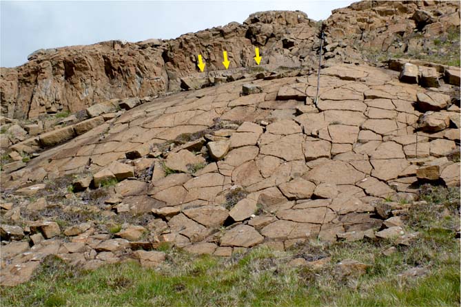
Figure 12 Intrusive/sheeted facies, TF-5, at the western end of the summit of Preshal Beg at c.[NG 3275 2795], consisting of thin auto-intrusive curved sheets of coarse basalt/dolerite with prismatic/polygonal joint sets and poorly developed chilled margins. Location of one intrusion margin is arrowed. Pole is c. 1 m long.
5.6.1. Interpretation
TF-5 is interpreted as being the product of near-surface auto-intrusive processes during the latter stages of flow emplacement. However, many of the features bear resemblance to other phenomena (see below) and the overall interpretation may necessarily invoke more than one simple process.
The surface characteristics, overall geometry and sizes of the dish-, ridge- and dome-shaped structures within the uppermost entablature of Preshal Beg are similar in appearance to those described for surface and near-surface features such as pressure ridges and other inflation structures (e.g. Macdonald Reference Macdonald, Hess and Poldervaart1968; Self et al. Reference Self, Finnemore, Thordarson and Walker1991; Walker Reference Walker1991; Wilson & Parfitt Reference Wilson and Parfitt1993; Chitwood Reference Chitwood1994; Hon et al. Reference Hon, Kauahikaua, Denlinger and Mackay1994; Rossi & Gudmundsson Reference Rossi and Gudmundsson1996; Whitehead & Stephenson Reference Whitehead and Stephenson1998; Zimbleman Reference Zimbleman1998). Such features are commonly associated with large, slowly effused pāhoehoe flows erupted onto shallow slopes, distal parts of lavas, perched lava ponds, and on the surfaces of thick lavas that have ponded within craters. Once a flow front has stopped advancing, inflation (shallow intrusion), possibly as a series of distinct pulses (cf. Anderson et al. Reference Anderson, Stofan, Smrekar, Guest and Wood1999) occurs, causing the surface crust to rise, tilt, buckle and crack, forming slabs with complex fracture patterns. Such structures, including ‘slabby pāhoehoe’ (e.g. Cashman et al. Reference Cashman, Thornber and Kauahikaua1999) and ‘platy-ridge flows’ (e.g. Keszthelyi et al. 2004) are associated with brecciated flow surfaces, which have low preservation potential. They are relatively rare in continental flood basalt provinces; however, they are not entirely unknown. Mackin (Reference Mackin1961) describes the upper surface of the Rocky Coulee Basalt Member (Yakima Basalt Subgroup, CRBG) as being typically pāhoehoe, with glassy-surfaced convolutions with a few metres of local relief. Self et al. (Reference Self, Thordarson, Keszthelyi, Mahoney and Coffin1997) and Thordarson & Self (Reference Thordarson and Self1998) also document several tumulus structures from other lavas from the CRBG. Their illustration (Self et al. Reference Self, Thordarson, Keszthelyi, Mahoney and Coffin1997, fig. 5(d)) from the Roza Member of the Wanapum Basalt Formation is compellingly similar to the Preshal Beg features. Such anticlinal structures are formed by the upheaval of already-solidified lava crusts and their cracking open in an irregular fashion. On oval-shaped pressure ridges, the fracture patterns tend to trend parallel to the ridges. Macdonald (Reference Macdonald, Hess and Poldervaart1968) explained their formation by the buckling of a flow crust close to the edge of the flow, which for the TF lava is (most likely) along the north face of both outliers, where the flow is restricted by a sidewall.
Studies of lava lakes (Peck et al. Reference Peck, Wright and Moore1966; Macdonald Reference Macdonald, Hess and Poldervaart1968; Peck & Minakami Reference Peck and Minakami1968; Swanson et al. Reference Swanson, Duffield, Jackson and Peterson1972; Peck & Kinoshita Reference Peck and Kinoshita1976; Wright & Okamura Reference Wright and Okamura1977; Peck Reference Peck1978; Wright & Peck Reference Wright and Peck1978; Helz Reference Helz and Mysen1987; Worster et al. Reference Worster, Huppert and Sparks1993) and modelling of joints by Budkewitsch & Robin (Reference Budkewitsch and Robin1994) indicate that initial flow-surface fracture patterns, though polygonal, are more hackly and not as regular as later-formed pseudo-hexagonal columnar fractures within a cooling flow. The polygonal cracking pattern noted on the surfaces of the auto-intrusive sheets on Preshal Beg (Fig. 12) is similarly less regular than that in either the lava's true entablature (TF-4) or colonnade (TF-2), lending support to our supposition that these structures reflect near upper flow-surface phenomena. The margins of these sheets, in so much as they would have acted as foci for joint surface development and as accessible conduits for surface water penetration, may well have accelerated the cooling history of the rest of the lava. Examples of similar lenticular ‘ponded’ or ‘channelised’ bodies with prismatic to upright columns, and discrete ovoid masses with radial prismatic joints close to flow bases, have been recorded from several localities, worldwide. They also occur within several of the classical ‘Staffa-type’ lavas (Staffa Lava Formation) of Mull (Bailey et al. Reference Bailey, Clough, Wright, Richey and Wilson1924; Williamson & Bell Reference Williamson and Bell2012). They may represent sections through mega-pillows (Bartrum Reference Bartrum1930; Walker Reference Walker1992), lava tubes (Lutton Reference Lutton1969) and pāhoehoe lobes (cf. Self et al. Reference Self, Thordarson, Keszthelyi, Mahoney and Coffin1997, fig. 2(a)), or merely zones of radial quenching and cooling (Justus Reference Justus1978; Long & Wood Reference Long and Wood1986, Reference Long and Wood1987), or the inward cooling of the last mobile portions of sheet flows (Greeley et al. Reference Greeley, Fagents, Harris, Kadel and Williams1998).
It is clear, therefore, that the irregular joint patterns within TF-4 and especially the distinctive TF-5 on Preshal Beg, are not due simply to an irregular cooling history of the upper portion of a single, homogeneous (or near-homogeneous) mass of magma emplaced as a single event (cf. Tomkieff Reference Tomkieff1940; Spry Reference Spry1962; Macdonald Reference Macdonald, Hess and Poldervaart1968; Saemundsson Reference Saemundsson1970; Long & Wood Reference Long and Wood1986, Reference Long and Wood1987; Cas & Wright Reference Cas and Wright1987; Lyle Reference Lyle2000), but are the consequence of a complex emplacement history. This involved mainly the auto-intrusion of a myriad of irregular sheets, tubes and pāhoehoe-style lava lobes, near the top of the ponded flow, but perhaps also included the injection of subsequent pulses of magma following flow-inflation. In this respect, it ought to be acknowledged that the conclusions of Harker (Reference Harker1904) that the Talisker outcrops are remnants of one or more multiple sills, may not have been too far off the mark.
6. Geochemistry
The geochemistry of the TF lava has been studied by several researchers (Thomson et al. 1972; Esson et al. Reference Esson, Dunham and Thompson1975; Williamson Reference Williamson1979; Moorbath & Thompson Reference Moorbath and Thompson1980; Dickin et al. Reference Dickin, Jones, Thirlwall and Thompson1987). Compositionally, the lava is classified as a low-alkali, high-calcium olivine tholeiite basalt, in marked contrast to the alkali–olivine basalts (and their differentiates) that comprise much of the Skye Lava field (the Skye Main Lava Series (SMLS) of Thompson et al. Reference Thompson, Esson and Dunham1972). The TF lava also has a distinctive (depleted) trace-element and REE signature (Esson et al. Reference Esson, Dunham and Thompson1975; Thompson Reference Thompson1982). Williamson (Reference Williamson1979) described a minor, but nevertheless possibly significant, variation between the two outliers, indicative of two distinct pulses during a single eruptive event, and also a minor degree of internal variation. Petrographically, the Talisker lava is a sparsely plagioclase- and olivine- micro-porphyritic basalt with considerable grain-size and textural variation.
7. Age and compositional relationships of the Talisker Formation and the Skye Central Complex
The earliest magmas associated with the Cuillin Intrusive Centre of the Skye Central Complex, interpreted as the eroded hearth of a ‘Cuillin Volcano’, have Skye Main Lava Series (SMLS) compositions (Thompson et al. Reference Thompson, Esson and Dunham1972; Hamilton et al. Reference Hamilton, Pearson, Thompson, Kelley and Emeleus1998), which suggests that a shield volcano may have been present during the later stages of the development of the Skye Lava Field, but prior to the eruption of the TF lava. The geochemical affinities between the TF (Thomson et al. 1972; Esson et al. Reference Esson, Dunham and Thompson1975; Williamson Reference Williamson1979), much of the Skye Dyke Swarm (Mattey et al. Reference Mattey, Gibson, Marriner and Thompson1977) and the Cuillin Intrusive Centre cone-sheets (Bell et al. Reference Bell, Claydon and Rogers1994) strongly suggest that these distinctly tholeiitic magmas were the product of a discrete melt extraction event from the mantle during the early Palaeogene and were essentially contemporaneous.
Some indication of the absolute age of the TF lava may be inferred from isotopic age data. First, at the top of the SMLS, below the TF lava, but not necessarily the youngest pre-TF event, is the Sleadale Tuff, which has a 40Ar-39Ar age date based upon biotite and anorthoclase mineral separates of 58.91±0.18 Ma (Bell & Williamson Reference Bell, Williamson and Trewin2002). Secondly, Hamilton et al. (Reference Hamilton, Pearson, Thompson, Kelley and Emeleus1998) calculated a U–Pb age of 58.91±0.07 Ma for zircon crystals extracted from a gabbro within the Cuillin Intrusive Centre. Consequently, given the quoted errors on these age dates, it may be inferred that there was some degree of overlap between the eruption of the Sleadale Tuff, possibly one of the last volcanic units of the transitional SMLS of the Skye Lava Field, and the development of the ‘Cuillin Volcano’ (including the sub-volcanic gabbros of the Cuillin Intrusive Centre). We conclude that the down-wasting and erosion necessary to produce the palaeo-canyon(s) subsequently inundated by the TF lava took place during a relatively short time interval, perhaps aided by the uplift that took place as the Skye Central Complex developed through the multiple injection of magmas into the hearth of the Cuillin Volcano (Walker Reference Walker, Pritchard, Alabaster, Harris and Neary1993b, Reference Walker and Le Bas1995). During this uplift, a radial drainage pattern may be expected to have developed, subsequently utilised by the alluvial and fluvial systems responsible for the bulk of the Preshal Beg Conglomerate Formation and the effusive volcanism now represented by the TF flow field.
8. Flow type, effusion rates, volumes and travel time
The TF represents a single flow field, and the outliers of Preshal More and Preshal Beg the remains of two separate lava streams that became impounded in a system of palaeovalleys or canyons within the Talisker Graben. A direct analogy may be drawn between them and the 1783 eruptions at Laki and Grímsvötn, Iceland (Thordarson & Self Reference Thordarson and Self1993). Other NAIP lavas, such as units of the Staffa Lava Formation, Mull, may also be effectively modelled in this way (Bell & Williamson Reference Bell, Williamson and Trewin2002; Williamson & Bell Reference Williamson and Bell2012). Apart from where there is evidence of lava-water interaction (in the underlying sedimentary breccias and the pillow-breccia-like basal facies), the lava base at both outliers has a smooth flow-banded appearance; there is no obvious basal rubble or breccia-carpet, as generally found in thick a'a-type flows. The architecture and internal structure of the lava are indicative of it having being emplaced rapidly, ostensibly forming single, near homogenous, static cooling units. In the case of the Preshal Beg outlier, the presence of TF-5 facies suggests that this particular lava stream was delivered in a pulsed manner through a large-scale inflation process, possibly involving a system of long, shallow lava tubes originating several kilometres up-slope. There is no evidence for either lava stream being emplaced as a lava lake infilling a volcanic crater (cf. Eyal et al. Reference Eyal, Becker and Samoylov1996) over a highly localised source vent or fissure. We consider it more likely that they are relatively far-travelled lava streams (or lobes, using the terminology of Thordarson & Self (Reference Thordarson and Self1993)) that originated from the putative Cuillin Volcano, located on the uplifted axial zone of the Skye Dyke Swarm.
Similarities between the Laki-Grímsvötn lava(s) (Thordarson & Self Reference Thordarson and Self1993) and the TF are strong. However, as mentioned above, in order to travel the relatively short distance to the Talisker area (c. 15 km), whilst retaining their heat and maintaining their low viscosity, they were in all likelihood fed by ‘upslope’ subsurface tubes. Flow length depends on a number of factors (Pinkerton & Wilson Reference Pinkerton and Wilson1994), such as mean effusion rate (Walker Reference Walker1973; Kilburn Reference Kilburn and Sigurdsson2000) and erupted volume (Malin Reference Malin1980), as well as cooling rate (heat loss) (Harris & Rowland Reference Harris, Rowland, Thordarson, Self, Larsen, Rowland and Hoskuldsson2009), composition, crystallinity, time and slope. That cooling rate can affect flow length is clearly shown by the degree to which the lengths of tube-fed lavas out-distance their channel-fed counterparts. Tubes transport magma efficiently, insulating active streams, allowing flows to travel greater distances over wider areas (Wilson et al. Reference Wilson, Pinkerton and Macdonald1987; Harris & Rowland Reference Harris, Rowland, Thordarson, Self, Larsen, Rowland and Hoskuldsson2009) and can therefore play a major role in the construction of low-angled shield volcanoes (Peterson et al. Reference Peterson, Holcomb, Tilling and Christiansen1994). Their importance in forming particularly long and far-travelled basaltic flows in flood-basalt terrains has been recognised and well documented (Atkinson et al. Reference Atkinson, Griffin and Stephenson1975; Hon et al. Reference Hon, Kauahikaua, Denlinger and Mackay1994; Self et al. Reference Self, Thordarson, Keszthelyi, Walker, Hon, Murphy, Long and Finnemore1996; Kauahikaua et al. Reference Kauahikaua, Cashman, Hon, Mattox, Heliker, Mangan and Thornber1998). On this basis, most intracanyon flows from the CRBG, even considering the vast volumes implied, must have been fed through robust and long-lived tube systems. The structures present in the TF lava suggest that it was emplaced as a low-effusion rate, pāhoehoe flow. Cashman et al. (Reference Cashman, Pinkerton and Stephenson1998, Reference Cashman, Thornber and Kauahikaua1999) showed that the transition from pāhoehoe to a'a flow morphology in open channels during the 1997 eruption of Kilauea took place only 1.9 km from the source vent. With this in mind, we contend that the TF lava outcrops are 13–15 km from the most likely source, in the vicinity of the present day Cuillin Hills. Distribution of the TF lava via two lava streams with lava-channel systems that were fully open for all of their length seems unlikely, and that it better fits the ‘master tube-contained basalt’ flow type of Harris & Rowland (Reference Harris, Rowland, Thordarson, Self, Larsen, Rowland and Hoskuldsson2009). Open lava channels are not, however, an impossibility, as the longest surface fed flow on Mauana Loa, Hawaii, that did not reach the sea, is reportedly the 1859 flow which was some 51 km long (Rowland & Walker Reference Rowland and Walker1990; Keszthelyi & Self Reference Keszthelyi and Self1998, table 1). The TF lava was erupted subaerially and, in all likelihood, quickly became tube-fed over much of its length and especially towards its termination points, where its two constituent lava streams became impounded as ponded flows in incised river valleys within the wider Talisker Graben. It is, however, important to stress that the original channels were most likely controlled by pre-existing, well-developed river valley channels and that this morphology continued to exert a strong influence during the tube-fed phase. Similar controls have been recognised by Atkinson et al. Reference Atkinson, Griffin and Stephenson1975, Stephenson & Griffin (Reference Stephenson, Griffin and Johnson1976), Cashman et al. (Reference Cashman, Pinkerton and Stephenson1998) and Stephenson et al. (Reference Stephenson, Burch-Johnston, Stanton and Whitehead1998). The effusion rates applicable to CRBG lavas, especially the very voluminous or far-travelled flows, is a contentious issue still currently under debate. Early models (Shaw & Swanson Reference Shaw, Swanson, Gilmore and Stradling1970) assumed that they necessitated high effusion rates and rapid emplacement. Although this model still has its adherents (Reidel & Tolan Reference Reidel and Tolan1992; Reidel Reference Reidel1998), there is a large body of opinion more in favour of low effusion rates coupled to compound tube-fed, inflation mechanisms operating over long time periods, possibly even decades (Self et al. Reference Self, Thordarson, Keszthelyi, Walker, Hon, Murphy, Long and Finnemore1996, Reference Self, Thordarson, Keszthelyi, Mahoney and Coffin1997, Reference Self, Keszthelyi and Thordarson1998; Keszthelyi & Self Reference Keszthelyi and Self1998). Data presented by Keszthelyi & Pieri (Reference Keszthelyi and Pieri1993) for the 75 km-long Carrizozo lava flow field in New Mexico also indicate flow field emplacement through a long-lived and far travelled (from source vent) lava tube system fed by steady, decade-long, low-effusion rate eruptions. They discounted both topography and unusually low viscosity as controls upon distance travelled. In contrast, high, continuous effusion rates and lava-tube systems were favoured by Stephenson & Griffin (Reference Stephenson, Griffin and Johnson1976) for far-travelled flows in north Queensland, Australia, but they also thought that the flows involved did not have particularly low viscosity. The physical requirements for, and constraints on, the emplacement of long basaltic lava flows either through rapid effusion (surface) or insulated (tubes etc.) mechanisms have been discussed by Keszthelyi & Self (Reference Keszthelyi and Self1998). The effusion rates for the relatively short-lived, pulsed eruption of the Grímsvötn lava(s) (Thordarson & Self Reference Thordarson and Self1993) of c. 4,000 m3.s-1 may be comparable to those of some CRBG flows, as proposed by Self et al. (Reference Self, Thordarson, Keszthelyi, Mahoney and Coffin1997) and Thordarson & Self (Reference Thordarson and Self1998).
The volumes of individual lava flows from the NAIP are difficult to estimate because of a lack of correlation in sections, but they still pale into insignificance behind most of those from the CRBG. The original volume of the TF lava is unknown. Individually, the outliers as they stand today are comparable in size to that of the Mount Arod lava lake (Eyal et al. Reference Eyal, Becker and Samoylov1966) at c. 0.35 km3. However, if we simply assume certain criteria regarding its original extent, e.g. the flow filled the Talisker Graben to a depth equal to its preserved maximum thickness (c. 120 m) and, to a lesser extent (c.100 m, but decreasing abruptly to, say, c. 25 m) over an unspecified area upslope towards its source fissure system, but was also impounded to the north in Gleann Oraid and near the present day sea cliffs to the south, then a volume of the order of c.1.10 km3 to 1.25 km3 is achieved. This should be considered a minimum value and it is interesting to note that it compares favourably with the upper end of the volume range estimated for some of the compound pāhoehoe flows in the early Mull Lava Field by Kent et al. (Reference Kent, Thomson, Skelhorn, Kerr, Norry and Walsh1998). If the area inundated by the Talisker flow field was larger, for example if both the palaeo-drainage channels and the graben were overtopped, then a revised figure of perhaps c. 3–5 km3 might be possible. Simple calculations for some of the Staffa Lava Formation units on Mull give similar figures. However, both are still an order of magnitude below that of the Laki-Grímsvötn eruptions of 1783 (Thordarson & Self Reference Thordarson and Self1993), which produced one of the largest basaltic lava flows in historical times, with an estimated value of 14.7±1 km3.
9. Landscape development, environments and emplacement of the Talisker Formation
The landscape developed across the early Skye Lava Field immediately prior to the eruption of the TF lava was complex and varied, comprising a low- to medium-relief plateau cut by a series of largely fault-controlled river valley systems with constituent cliffs, gorges (canyons) and local fluvial outwash plains (Williamson & Bell Reference Williamson and Bell1994; Bell & Williamson Reference Bell, Williamson and Trewin2002). Jefferson et al. (Reference Jefferson, Grant, Lewis and Lancaster2010) have shown that in recently erupted and hence highly permeable basaltic terrains, such as the Cascade Range in the western USA, the development of surface drainage systems and significant fluvial incision occurs only after springs are replaced by shallow subsurface groundwater storm flow. They also quote studies (e.g. Baker & Gulick Reference Baker and Gulick1987; Baker Reference Baker, Howard, Kochel and Holt1988; Gulick & Baker Reference Gulick and Baker1990) from various basaltic volcanic terrains, concluding that there is a general trend of increasing fluvial incision and drainage density over timescales of 0.1–5 million years, with climatic conditions a major controlling factor; other factors are relief and lithology. Clay-rich soil development by chemical weathering (e.g. laterite formation) also influences (lowers) basalt field permeability and so enhances surface flow and, with it, erosion potential and channel development e.g. on Hawaii (Lohse & Dietrich Reference Lohse and Dietrich2005). Age determinations of the Sleadale Member tuff (58.91±0.18 Ma) and the TF lava (58.5±0.5 Ma) suggest that such systems on the Skye Lava Field must have developed within a maximum timescale of 1 million years but may, driven by a warm temperate climate, have evolved quite quickly, possibly in <100,000 years. The emplacement and form of the TF lava was, in part, controlled by this palaeo-topography and palaeo-drainage system. Other factors influencing landscape and emplacement include the location of the source vent or fissure and the wider regional structure and palaeo-slopes (consequent upon sustained relief) around the developing Cuillin (shield) Volcano, and to some degree, the nature of the magma itself.
This local scenery would probably have been dominated by the rising ground towards the developing Cuillin Volcano to the SE, with the eroded remnants of the earlier Rum Volcano also visible in the distance further to the south (Figs 1, 13). However, unlike during the earlier development of the Skye Lava Field, when the vigorously eroding Rum Volcano and its hinterland almost certainly supplied the granitic and felsitic clasts of early Palaeocene age and the Proterozoic Torridonian (Supergroup) sandstone and arkose clasts found within the Minginish Conglomerate Formation (Williamson Reference Williamson1979; Meighan et al. Reference Meighan, Hutchison, Williamson and Macintyre1981; Williamson & Bell Reference Williamson and Bell1994), the fact that the PBCF appears free of any such epiclastic material suggests that by this time sediment supply from the south was effectively cut-off. The drainage pattern was most likely radial to the area of uplift of the Cuillin Volcano, but with local fault-control of lava distribution still effective in the lava field at greater distances. This scenario of low to moderate topographic relief in the Talisker area in comparison to the area of the Cuillin Volcano seems to be at odds with Jolley's (Reference Jolley and Widdowson1997) conclusion, based (solely) on palynological data, that the palaeo-surface and sedimentary deposits represented by the PBCF are of the same age as interflow conglomerates and sandstones in a most distal part of the Skye lava field further north in Glen Osdale (Anderson & Dunham Reference Anderson and Dunham1966), and are also part of the same drainage system (Jolley Reference Jolley and Widdowson1997; Fig. 7d). As the Osdale rocks are lithologically very similar to those of the older Minginish Conglomerate Formation, and occur broadly at the same stratigraphical level relative to the base of the lava field, we contend that this a more likely correlation.

Figure 13 An artistic reconstruction of the possible landscape of the Skye Lava Field immediately following emplacement of the Talisker Formation flow field. A youthful shield volcano probably existed above the developing Cuillin (intrusive) Centre in the area now formed by the Cuillin Hills. Satellite ash and cinder cones developed above vent-fissures along the main axis of the NW–SE-trending regional dyke swarm. The older, unroofed and down-wasting Rum Volcano could be seen in the distance. Previously the Rum area had supplied the epiclastic material found in the Minginish Conglomerate Formation (Williamson & Bell Reference Williamson and Bell1994) but palaeotopography around the rising Cuillin Volcano now prevents any material from that source reaching the Skye Lava Field.
If the drainage pattern and source had shifted as suggested, effectively barring input from the Rum–Canna area (Figs 1, 13), then it is difficult to explain the presence of these epiclasts at this stratigraphical level and in sediments thought by Jolley (Reference Jolley and Widdowson1997) to be more distal equivalents of the same fan-fluvial system as the epiclast-free PBCF. The only way that such epiclasts sourced from the Rum area could conceivably have reached NW Skye at this time would have been via the continued existence of a S–N-directed valley with an active fluvial system west of, and running marginal to, the Talisker area and bounded and deflected by the high ground around the Cuillin Volcano. The PBCF would not, therefore, form part of this major drainage system, though streams developing radially from the uplifted Cuillin area may have been captured by it.
Jolley's (Reference Jolley and Widdowson1997) data suggest that the source area for the PBCF was rich in upland Taxodiacaea forest, with the additional presence of some riparian and swamp environments and montane conifer forest developed on the highest areas. He also used the palynofloras associated with various palaeo-surfaces within the Skye Lava Field to estimate palaeo-surface altitudes. These data, when combined with thickness estimates for the various volcanic formations (Williamson & Bell Reference Williamson and Bell1994), allowed construction of a tectonic history for the area. The top of the PBCF is associated with a lateritised palaeo-surface (surface E5 of Jolley Reference Jolley and Widdowson1997) that is estimated (by Jolley Reference Jolley and Widdowson1997) to have formed at an altitude of c. 500 m. According to Jolley (Reference Jolley and Widdowson1997), the stratigraphically highest units of the underlying Gleann Oraid Formation were not extensively eroded and are only preserved because the local lava field underwent rapid subsidence (of the order of c. 1000 m) prior to E5 time.
Field data from the Talisker area shows this to be misleading, if not exactly incorrect, and instead suggests very considerable erosion and deep incision of the Gleann Oraid Formation lavas, most likely consequent upon significant uplift, prior to the eruption of the TF lava. The linking of sedimentary and volcano-stratigraphic processes in the Hebridean part of the NAIP has been suggested by Brown et al. (Reference Brown, Halohan and Bell2009). In detail, the history and palaeo-geography of the Talisker area are much more complex. The base of the Sleadale Member (uppermost Gleann Oraid Formation), for example, also overlies an erosional unconformity surface. This was developed on the mugearite- and hawaiite-dominated Arnaval Member and, itself, represents a considerable time interval between members. The total duration of the time interval between the eruption of the uppermost Arnaval Member lavas beneath this surface and the emplacement of the TF lava is not known, but it was undoubtedly considerable (see above). There may well have been several ‘cycles’ of uplift and subsidence, erosion and sedimentation within this time period.
The base of the TF on both outliers is inclined towards the NW, largely in keeping with the regional dip, but slightly steeper. Also, at Preshal Beg, the base is topographically higher than the base at Preshal More (c. 240 m AOD relative to c.170 m AOD). There are no obvious faults between the two hills. The regional dip of the lava field in west-central Skye is towards the NW, consistent with later basin-inward subsidence towards the Bracadale region (to the north) where the lava pile is most likely thickest (England Reference England1994). However, block faulting and gentle arching have produced a number of irregularities. Below the TF lava, and also in the adjacent fault blocks (BGS 2000), the dips are either sub-horizontal or gently inclined towards the north or south, and there is a shallow angular disconformity between the TF lava and the older lavas. This feature is most obvious where there is no intervening PBCF, as on the NW face of Preshal More and along the SE side of Preshal Beg. In addition, there are many differences in detail of the structural levels of both base and top of the PBCF on Preshal Beg. This may indicate primary lateral variations in the architectural arrangement of the constituent lithofacies, interaction between the flow base and poorly-consolidated and water-logged sediments, or the existence of a small but significant constructional palaeo-topography at the time of eruption. Locally, this might have included pre-, syn- and post-flow emplacement faulting. A similar scenario, linking recurrent faulting, multiple erosion surfaces, sedimentation and, finally, intracanyon volcanism, has also been demonstrated for some Miocene flows in Arizona (Holm & Cloud Reference Holm and Cloud1990). Palaeo-fault escarpments may therefore have defined the edge of the proto-Talisker Graben (e.g. at the NE margin of Preshal More) and possibly help explain some of the features noted on the eastern flanks of Preshal Beg.
10. Deposition of the Preshal Beg Conglomerate Formation (PBCF) and eruption and emplacement of the Talisker Formation (TF) flow field
We propose the following multi-stage model for the geological evolution of the Talisker area and in particular the emplacement of the TF lava.
10.1. Phase 1
Eruption and emplacement of the hawaiite- and mugearite-dominated Arnaval Member of the Gleann Oraid Formation (Figs 3, 4). Waning intensity and frequency of volcanic activity led to lengthy time intervals between the later eruptions and promoted the development of palaeosols, channelling of flows and some localised unconformities. Burial of these lavas to a substantial depth (possibly by as much as 1.5 km locally). The extent and thickness of the lava pile allowed the onset of depth-related (hydrothermal) metamorphism, secondary mineralisation and the establishment of zeolite zonation patterns.
10.2. Phase 2
A hiatus in volcanic activity then followed, during which time there was extensive faulting of the lava field. Following intense weathering, erosion was rapid and significant, exposing lower units of the Arnaval Member. Volcanism, including hydrothermal activity, and some updoming may have continued in the region to the SE (where the present-day Cuillin Hills are located) and close to the axis of the Skye Dyke Swarm. The last pre-TF eruptions in the Talisker area comprised the emplacement of the Sleadale Member (Gleann Oraid Formation) trachyte (crystal-rich lapilli tuff and lava domes) within the proto-Talisker Graben (at 59.81 Ma; Bell & Williamson Reference Bell, Williamson and Trewin2002).
10.3. Phase 3
Effusive volcanic activity in the Talisker area then effectively ceased, although hydrothermal and solfataric activity may have continued for some time. Thereafter, there was a slow but inexorable uplift in the vicinity of the developing Cuillin Volcano / Intrusive Centre. There was also perhaps still some additional or continued concomitant basinal subsidence to the north, in the Bracadale region – the structural ‘depocentre’ of the lava field (England Reference England1994). This resulted in a significant N- to NW-directed palaeo-slope. During this protracted, relatively (volcanically) stable period – the canyon-forming phase – the volcanic uplands may have been semi-arid but prone to torrential flash-flooding as rivers struggled to reach new base levels. Many environments suitable for the development of deep weathering profiles and palaeosols, deep-incision erosion and the establishment of a complex (possibly Cuillin-radial) palaeo-drainage system were created. Escarpments, valleys and drainage systems would also have been strongly influenced by fault patterns.
10.4. Phase 4
Erosion of the existing lava field and any unconsolidated pyroclastic rocks in the region of the Cuillin Volcano continued and the PBCF was emplaced. Initially there was gradual infilling of palaeo-channels and valleys by various sedimentary lithofacies representing talus, alluvial fan and minor stream environments. Although perhaps initially exacerbating slope erosion and deepening canyons, a series of debris flows, as they waned, deposited the heterogeneous conglomerates of facies PBCF-1 resulting in the partial blockage of local valley-drainage systems. Sediment transport may have been initiated by catastrophic failures on the deeply-weathered slopes of the growing Cuillin Volcano to the SE (cf. Brown et al. Reference Brown, Halohan and Bell2009). Increased hydrothermal and seismic activity ahead of the eruption of the TF flow field and heavy seasonal rainfall and flash-flooding are likely contributors. The composition of all the PBCF deposits indicates a purely local lava field origin; there appears not to have been a source of epiclastic material similar to that characterising the earlier Minginish Conglomerate Formation (Williamson & Bell Reference Williamson and Bell1994).
10.5. Phase 5
Local differential uplift, faulting, erosion and sedimentation continued in the Talisker area, with some weathering and minor incision of both the volcanic hinterland and the existing, largely unconsolidated debris-flow deposits of the PBCF by ephemeral streams. The finer-grained and more structured lithofacies of PBCF-2 were deposited under much less energetic stream-flow conditions. The deposits represent the end phases of debris flow deposition, followed by the establishment of shallow lacustrine and minor deltaic environments. The area may still have been seasonally semi-arid to wet-temperate and subject to flash-flooding events. There was probably significant vegetation cover, dominated by a Taxodiacaea forest (Jolley Reference Jolley and Widdowson1997).
10.6. Phase 6
Further central uplift in the Cuillin area was followed by a resumption of surface volcanic activity and some faulting as the Cuillin (shield) Volcano became established. A major flank fissure eruption on the volcano's slope apron, most likely along the site of the present-day dyke swarm axis, produced the TF flow field. Uplift in the Cuillin area by up to 1 km is thought to have been caused by the emplacement at depth of gabbroic and peridotitic ring intrusions, and cone-sheets, and there would also have been uplift along the line of any developing fissure. The geochemistry of cone-sheets emplaced into the Cuillin Intrusive Centre (and much of the regional dyke swarm) matches that of the TF lava, implying these to be genetically linked.
The TF flow field was initially erupted in a series of pulses as a voluminous sheet-flow from a vent-fissure system (situated up- palaeo-slope), most likely to the south or east, of the present-day outcrops. There is no record of any pyroclastic activity having immediately preceded the eruption of the lavas, but it is likely that there was extensive fire-fountaining along the rift (i.e. the axis of the dyke swarm), comparable perhaps to the so-called ‘Skáftar Fires’ that accompanied the Laki-Grímsvötn eruption(s) of 1783 in southern Iceland. Also, by this time, a compound volcanic edifice (Cuillin (shield) Volcano) had presumably developed to the south above the embryonic intrusive complex, with satellite tephra cones perhaps situated on the apron flanks along the axis of the regional dyke swarm. Much of this material may have been poorly- or totally-unconsolidated.
10.7. Phase 7
Due to irregularities in the topography on the volcano's flanks, the TF lava was not restricted to the area adjacent to the fissure, but was effectively diverted and channelled obliquely down the existing palaeo-drainage until its ultimate arrival in the Talisker area (and, most likely, beyond). The flow travelled far beyond its immediate eruptive source area, initially channelling down upland valleys, then through subsurface magma conduits. The flow most likely arrived as two separate lava streams, more or less simultaneously, and initially infilled deeper, steep-sided fluvial channels and gorges, akin to the Laki 1783 eruption (Thordarson & Self Reference Thordarson and Self1993). The presence of horizontal columnar joints on the northern flanks of both outliers suggests that, locally, these channels may have been aligned SE–NW, or that the flow streams encountered fairly major topographic barriers near their base. This direction is radial to the present-day Cuillin Hills and sub-parallel to the regional dyke swarm, and possibly represents an original palaeo-slope.
Self et al. (Reference Self, Keszthelyi and Thordarson1998) have suggested that the magma plumbing system beneath the lava fields of the NAIP did not usually allow large batches of magma to accumulate at any one time, so that most flows are thin in comparison to major flood basalt provinces such as the CRBG and the Deccan. Evidence from the TF lava suggests that during the development of the Cuillin Volcano, this plumbing system was largely by-passed and larger chambers were established. All indications are that the TF flow field, when compared to the vast majority of basaltic lavas in the NAIP, was comparatively voluminous, fluid and rapidly emplaced. The TF flow field was almost certainly erupted from a major fissure system in a single short-lived event. A similar mechanism is envisaged (Thordarson & Self Reference Thordarson and Self1993) for the 1783 Laki-Grímsvötn eruptions, with which the TF has already been compared.
If certain features of these flow streams are interpreted as being due to shallow auto-intrusion and inflation, then only gentle ground slopes (<4° and perhaps <0.5°) need apply (Kent et al. Reference Kent, Thomson, Skelhorn, Kerr, Norry and Walsh1998).
10.8. Phase 8
Eruption continued. The original channels/canyons were rapidly inundated, either by lava streams entering them directly from the direction of the Cuillin Volcano then overtopping, or by cascading flows originating from an area of uplift along the axis of the regional dyke swarm. In all probability, one or more large ‘lava lakes’ and smaller perched lava ponds were formed as the flow became impounded within the Talisker Graben. The flow inundated and buried the earlier drainage systems to a depth in excess of 120 m, displacing local water courses and bodies of standing water. This buried topographical surface was a complex one, with the TF flow disconformably onlapping various members of the Gleann Oraid Formation and the PBCF. That the principal drainage systems were still active and their associated sediments largely unconsolidated at the time of the eruption of the TF flow field is indicated by the presence of locally ‘invasive’ (shallow intrusive) phenomena within PBCF-3 deposits, chilled margins and a pillow-breccia-like facies at the base of the TF lava.
10.9. Phase 9
In-situ cooling and solidification of the two ponded lava streams (Preshal More and Preshal Beg) began, but was interrupted by further pulses of tube-fed magma emplaced beneath the surface carapace. The nature and style of the columnar joint sets and sheeted bodies towards the top of the present day outcrops (more especially on Preshal Beg) clearly demonstrate that shallow auto-intrusive activity (TF-5) occurred at this late stage during flow emplacement.
10.10. Phase 10
Slow cooling and solidification of the TF lava then proceeded. Joint systems developed and propagated perpendicular to the principal external cooling surfaces and internal isotherms. This resulted in near-vertical columnar joints where the base of the lava was in contact with the wet valley floor, whereas at the valley sides the joints are inclined, reflecting the profile of the valley. Locally, where the valley sides were near-vertical, the columnar joints developed a sub-horizontal attitude. There were other important controls on cooling and solidification, especially at higher structural levels within the flow. The complex arrangement of irregularly interfering, fanning, prismatic and columnar joint systems in the irregular columnar facies (TF-4) is thought to owe its formation to the disruption of isotherms by agencies such as the localised ingress of surface (meteoric) waters into the top of the flow. This could be achieved in part through rainfall during early cooling but was most likely due to the re-establishment of rivers and streams diverted and displaced during the emplacement of the flow itself. Flow-top topography is likely to have been somewhat irregular and shallow stream courses and lakes will have formed. Water ingress to the cooling interior of the flow would also have occurred locally where stream courses, diverted along the sides of the flow, became impounded and dammed.
Almost 59 million years of weathering and erosion have removed any vestige of subsequent Palaeogene sediments (or further lavas) that may have been deposited on top of the TF, but it is clearly possible in the scenario we put forward that significant fluvio-lacustrine sediments accumulated behind lava dams similar in fashion to the spectacular structures described from the late Cenozoic lavas of the western Grand Canyon, USA, by Hamblin (Reference Hamblin1994) and some of the intracanyon flows in the CRBG.
10.11. Phase 11
At some time after the emplacement and solidification of the TF lava, and while the area was still under an extensional regime, a significant amount of block-faulting took place. This resulted in features such as the Talisker Graben as defined today by the Talisker East and Talisker West faults (Fig. 2).
10.12. Phase 12
The TF is deemed to be the youngest preserved volcanic unit within the Skye Lava Field. In all likelihood it was subsequently buried by younger sediments, lava flows and pyroclastic deposits as various Cuillin (or somewhat younger Red Hill) volcanoes developed. However, the lack of zeolite mineralisation in either outcrop may be significant and interpreted as evidence for only minimal (<300 m?) cover. Subsequent to the complete cessation of the volcanic activity, further uplift, basin inversion and prolonged erosion have, over some 59 million years, removed any vestige of these late volcanic products from the lava field. This erosion, culminating in Pleistocene glacial events (a few glacial erratics of gabbro similar to that exposed in the Cuillin Hills are found on both summits for example) has also differentially removed a considerable thickness of the associated, relatively easily weathered and less resistant ‘softer’ older lavas, leaving two large outliers of this olivine tholeiite lava forming an inverted relief topography so characteristic of intracanyon flows.
11. Acknowledgements
Ian Williamson would especially like to thank Henry Emeleus, who, acting as his supervisor during his PhD studies at the University of Durham in the mid 1970s, first introduced him to the fascinating geology of the Talisker area. We both thank Henry and also David Jolley for many enjoyable discussions on the stratigraphy and palaeo-environments of the Skye and other Hebridean lava fields. Thanks also go to Stephen Reidel, Peter Hooper, Gary Byerly and James Anderson for answering specific questions regarding the Columbia River Basalt Group. David Brown generously assisted with the production of early versions of some of the line-drawing figures. We thank John Stevenson and Malcolm Hole for their thoughtful and constructive reviews.


