1. Introduction
The late Wenlock Series (Homerian Stage) of the northern Midland Platform consists of a succession of silty mudstones and limestones, comprising the upper part of the Coalbrookdale and the Much Wenlock Limestone formations. Deposition of these units took place on the gently subsiding eastern margin of the Welsh Basin, as part of a broad carbonate platform (for a review of palaeogeography, see Ratcliffe & Thomas, Reference Ratcliffe and Thomas1999, fig. 8, pp. 199–202; Cherns et al. Reference Cherns, Cocks, Davies, Hillier, Waters, Williams, Brenchley and Rawson2006). Exposures in the northern part of the platform are restricted to two key areas, the first along Wenlock Edge (Shropshire) and the second a series of small inliers situated between Dudley and Walsall in the West Midlands (Fig. 1). Both areas are of considerable scientific importance, with the Wenlock Series type area exposed at the northern end of Wenlock Edge (Bassett, Reference Bassett, Holland and Bassett1989; Aldridge et al. Reference Aldridge, Siveter, Siveter, Lane, Palmer and Woodcock2000), and the inliers of Dudley being famous for their exquisitely preserved and diverse fossil biotas (Ray & Thomas, Reference Ray and Thomas2007).

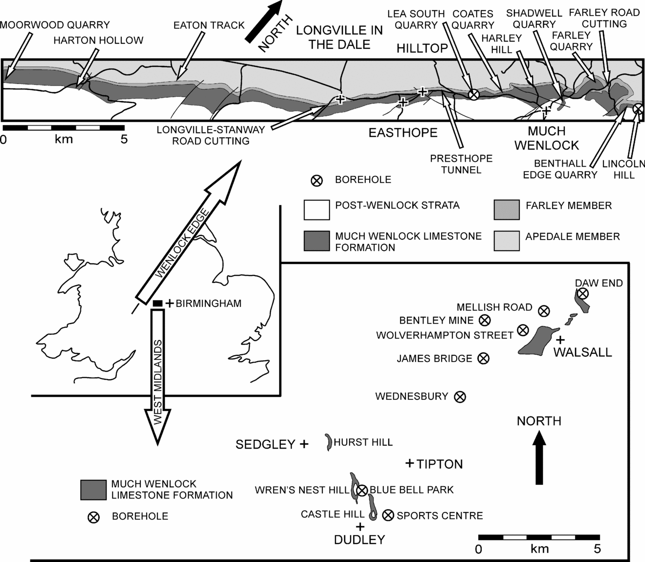
Figure 1. Location maps showing outcrop and borehole positions within the West Midlands and along Wenlock Edge. West Midlands: Wren's Nest Hill (SO 937 920), Blue Bell Park (SO 941 917), James Bridge (SO 992 975), Bentley Mine (SO 993 990), Daw End (SK 034 009), Mellish Road (SP 019 995), Sports Centre (SO 952 908), Wednesbury (SO 982 957), Wolverhampton Street (SP 008 989). Wenlock Edge: Moorwood Quarry (SO 453 855), Harton Hollow (SO 480 877), Eaton Track (SO 500 900), Longville–Stanway road cutting (SO 540 927), Presthope Tunnel (SO 581 974), Lea South Quarry (SO 594 982), Coates Quarry (SO 605 993), Harley Hill (SJ 609 004), Shadwell Quarry (SJ 625 010), Farley Quarry (SJ 630 015), Farley road cutting (SJ 637 026), Benthall Edge Quarry (SJ 664 034), Lincoln Hill (SO 681 037).
Regional differences in lithostratigraphy have complicated comparisons between Wenlock Edge and the West Midlands. Briefly, the Much Wenlock Limestone Formation of the West Midlands is divided into the Lower Quarried Limestone, Nodular Beds and Upper Quarried Limestone members (Dorning, Reference Dorning1983), and is approximately synchronous with the uppermost Apedale and Farley members of the Coalbrookdale Formation and the Much Wenlock Limestone Formation on Wenlock Edge (Dorning & Harvey, Reference Dorning and Harvey1999). There, the Much Wenlock Limestone Formation is divided into reef and off-reef tracts, based on the presence or absence of reefs in the upper 17 m of the formation (Scoffin, Reference Scoffin1971; Bassett, Reference Bassett, Holland and Bassett1989). The off-reef tract succession is divisible into the Longville and Edgton members (Bassett, Reference Bassett, Holland and Bassett1989). Within this framework, details of correlation are presently equivocal.
Graptolite biostratigraphy has shown the lithostratigraphical divisions of the late Wenlock Series to be diachronous in part (Bassett, Reference Bassett1976). In the West Midlands, the base of the Much Wenlock Limestone Formation lies within the lundgreni Biozone (Bassett, Reference Bassett1974), with the lower half of the Nodular Beds Member tentatively placed within the nassa Biozone on the basis of carbon isotope studies (Corfield et al. Reference Corfield, Siveter, Cartlidge and McKerrow1992). These data indicate equivalence with the uppermost Apedale (lundgreni Biozone) and Farley (nassa to lowest ludensis Biozone) members of the Coalbrookdale Formation on Wenlock Edge (Bassett, Reference Bassett1976, Reference Bassett, Holland and Bassett1989).
Attempts to correlate the top of the Much Wenlock Limestone Formation have suggested that it youngs from east to west. Using graptolite data, Bassett (Reference Bassett1974) initially suggested that the formation in the West Midlands was contained within the lundgreni Biozone, while on Wenlock Edge it was confined to the ludensis Biozone. However, limited graptolite faunas from within the overlying Lower Elton Formation later led Bassett (Reference Bassett1976) to conclude that the top of the formation in the West Midlands probably terminated within the ludensis Biozone, resulting in at least part of the Lower Elton Formation of that area being of latest Wenlock age. In contrast, Hurst (Reference Hurst1975) used brachiopod palaeocommunity data to suggest the top of the Much Wenlock Limestone Formation to be synchronous between Wenlock Edge and the West Midlands. Acritarch (Dorning & Bell, Reference Dorning, Bell and Hart1987) and carbon isotope excursion data (Corfield et al. Reference Corfield, Siveter, Cartlidge and McKerrow1992) also have cast doubt on a substantial degree of diachronism at the upper boundary.
The lithofacies identified in the Much Wenlock Limestone Formation allow only for the correlation of larger-scale lithological trends (Shergold & Bassett, Reference Shergold and Bassett1970; Scoffin, Reference Scoffin1971; Ratcliffe & Thomas, Reference Ratcliffe and Thomas1999). Individual lithofacies are prone to diachronism and lateral thickness variation, and may be discontinuous (Scoffin, Reference Scoffin1971, fig. 2, p. 179; Ratcliffe & Thomas, Reference Ratcliffe and Thomas1999, fig. 2, p. 191). On Wenlock Edge this problem is most noticeable within the reef tract (Scoffin, Reference Scoffin1971; Bassett, Reference Bassett, Holland and Bassett1989), while comparisons with the West Midlands are complicated further by the presence there of oncoid-bearing limestones (Lower Quarried Limestone Member) that are absent elsewhere.
Given the currently equivocal nature of late Wenlock stratigraphy in the northern Midland Platform, the purposes of this paper are firstly to improve correlation between Wenlock Edge and the West Midlands, and secondly to establish an accurate record of relative sea-level (RSL) change for the late Wenlock Series in its type area. We do not present comprehensive lithological descriptions or seek to redefine the lithofacies previously defined, but rather to identify and highlight the synchronicity of depositional events within the late Wenlock as a means of correlation.
1.a. Localities and resources
Along Wenlock Edge, the key sections identified in the establishment of the stratotype area (see Shergold & Bassett, Reference Shergold and Bassett1970; Bassett et al. Reference Bassett, Cocks, Holland, Rickards and Warren1975; Bassett, Reference Bassett, Holland and Bassett1989; Siveter, Owens & Thomas, Reference Siveter, Owens and Thomas1989; Aldridge et al. Reference Aldridge, Siveter, Siveter, Lane, Palmer and Woodcock2000, pp. 234–53) were logged in detail. These include Harton Hollow, Eaton Track, Longville–Stanway road cutting, Presthope Tunnel, Coates Quarry, Harley Hill, Shadwell Quarry and Farley Quarry (Fig. 1). In many instances, access to sections has been greatly reduced owing to increased vegetation cover, the infilling of quarries or changes in land ownership. However, the deterioration of some sections has been compensated for by more recent road cuttings and quarries. In particular, the recent excavation of Lea South Quarry and access to associated gamma ray logs has provided a near-continuous section through the Much Wenlock Limestone and basal Lower Elton formations. The Farley road cutting, created by a slight re-routing of the A4169 northeast of Much Wenlock, provides access to a significant proportion of the Farley Member and the Much Wenlock Limestone Formation, as has recent improvement to the Harley Hill section. A total of twelve significant of sections have been logged, from Moorwood Quarry, some 3 kms northeast of Craven Arms, northeastwards along Wenlock Edge to Benthall Edge Quarry and Lincoln Hill overlooking the Ironbridge Gorge, a distance of approximately 28 km (Fig. 1). Logging of several additional small quarries, between key sections, has further aided correlation.
Within the West Midlands, exposure is poor outside the Dudley inliers, but geophysical borehole data, originally obtained to investigate the stability of the numerous limestone caverns, are plentiful. Gamma ray, electrical resistivity logs and associated core descriptions, which allow limestone and mudstone variations to be identified, have been used to correlate from the exposure at Wren's Nest Hill through the subsurface to Daw End, a distance of approximately 13 km (Figs 1, 2, 4). Such data have allowed bentonite and silty mudstone beds as little as 40 mm thick to be traced, greatly improving correlation.

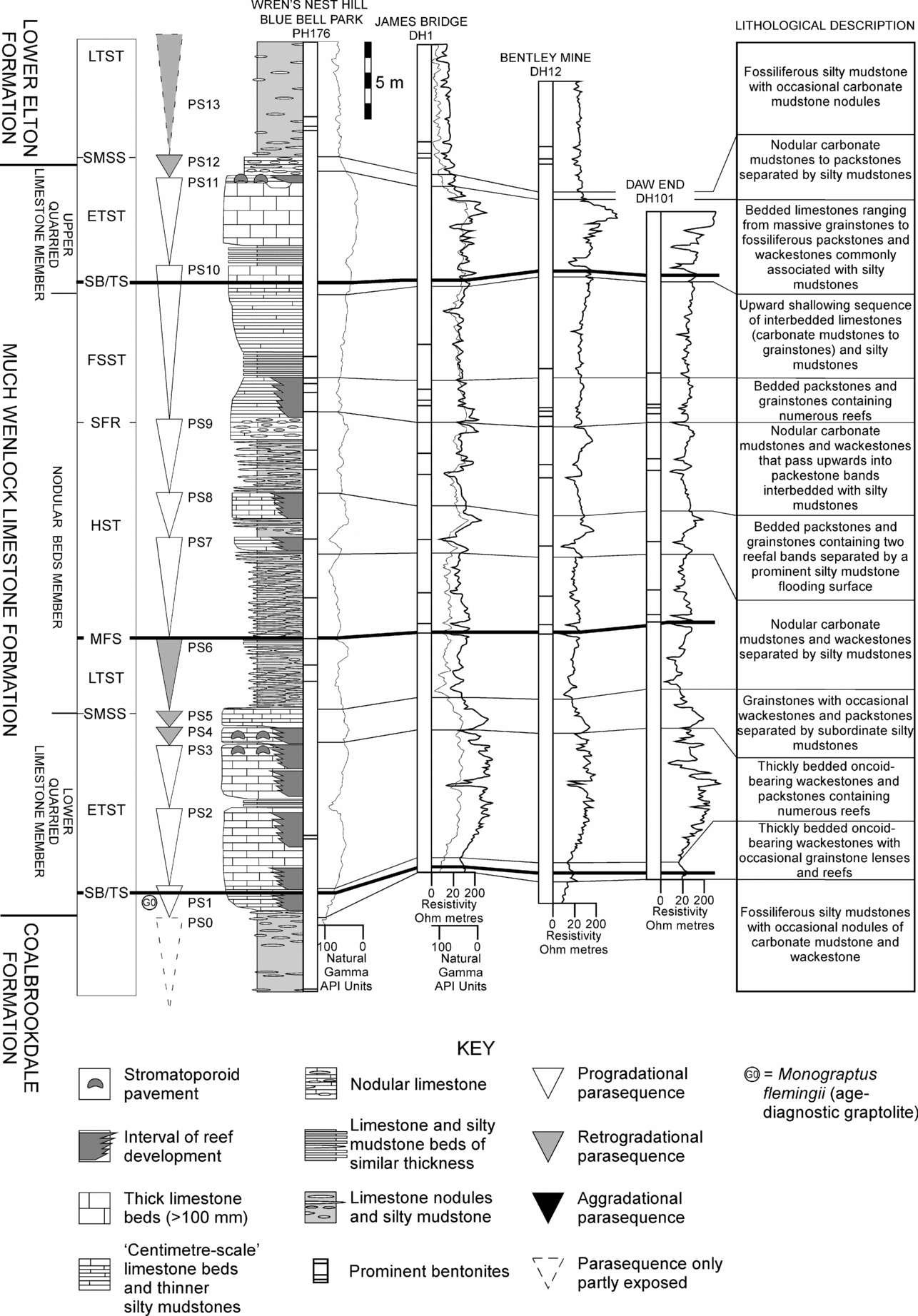
Figure 2. Correlation of the Much Wenlock Limestone Formation across the West Midlands. Within the West Midlands are the following systems tracts and their bounding surfaces: SB/TS – sequence boundary and combined transgressive surface; ETST – early transgressive systems tract; SMSS – surface of maximum sediment starvation; LTST – late transgressive systems tract; MFS – maximum flooding surface; HST – highstand systems tract; SFR – surface of forced regression; FSST – falling stage systems tract. As explained in the text, the lower sequence boundary is taken at a slightly higher level than before, and the upper sequence boundary is taken at a slightly lower level (see Ray & Thomas, Reference Ray and Thomas2007, p. 199, fig. 2).
1.b. Methods
The wealth of publications and research addressing the correlation of the late Wenlock in the study area demonstrate that a new approach is required to refine the stratigraphy further. Based upon the sequence stratigraphy developed for the Dudley inliers (Ray & Thomas, Reference Ray and Thomas2007), it is clear that the late Wenlock Series contains numerous parasequences (small-scale cycles), along with the bounding surfaces and systems tracts that make up a third-order cycle of RSL change. Assuming a similar subsidence history for the rest of the northern Midland Platform (Woodcock et al. Reference Woodcock, Butler, Davies, Waters, Hesselbo and Parkinson1996), some expression of the RSL changes identified in the Dudley inliers should be detectable across the study area. In order to detect the facies response to RSL change, attention has been paid to the identification of erosive surfaces, condensed sections, parasequences, flooding surfaces and indicators of palaeobathymetry such as faunal assemblages, sedimentary structures and lithology (see Brett, Boucot & Jones, Reference Brett, Boucot and Jones1993). Having established the net shallowing (progradational), stillstand (aggradational) or deepening (retrogradational) trend of parasequences, consideration has been given also to regional variations in palaeobathymetry. This is particularly important when considering the response of benthic carbonate production to sea-level change. For example, carbonate production, established during a period of relatively slow transgression may keep up with or exceed the rate of sea-level rise, resulting in aggradational or progradational parasequences, rather than the retrogradational pattern expected. Moreover, minor variations in seafloor topography will determine where carbonate production is first initiated. The main carbonate interval within the study area, the Much Wenlock Limestone Formation, developed first within the West Midlands and then along Wenlock Edge; the shallower water reef tract there was the likely area of initial carbonate production, followed by the off-reef tract.
Having established the lithological response to RSL change within any given section, features such as distinctive lithologies associated with prominent flooding surfaces, bentonites, and the number, thickness and stacking patterns of parasequences were used for correlation. Correlation has been achieved between sections containing age-diagnostic graptolites and the rest of the study area, thereby improving our stratigraphical knowledge significantly.
2. Correlation of the upper Wenlock Series
Owing to the limited biostratigraphical evidence for the exact correlation of the late Wenlock between Wenlock Edge and the inliers of the West Midlands, it is appropriate first to discuss the two areas separately. After establishing the stratigraphical framework within each of these, the potential for regional correlation will be discussed.
2.a. The West Midlands
The Much Wenlock Limestone Formation of the West Midlands consists of two shallow water limestones (Lower Quarried Limestone and Upper Quarried Limestone members), separated by a deeper-water nodular limestone and silty mudstone-rich interval (Nodular Beds Member), with a total thickness of 46.2–57.4 m. On the basis of a specimen of Monograptus flemingii collected 2.4 m above the base of the Lower Quarried Limestone Member (Butler, Reference Butler1939), an age no younger than the lundgreni Biozone has been inferred (Bassett, Reference Bassett1974) for that part of the sequence. No precisely located graptolites have been recovered from the remainder of the formation or the overlying Lower Elton Beds. However, graptolite specimens that are presumed to have originated from the exposed basal 10 m of the Lower Elton Formation at Dudley, suggest a Neodiversograptus nilssoni to Lobograptus scanicus biozone age (Bassett, Reference Bassett1976). It therefore seems likely that the upper parts of the Much Wenlock Limestone Formation there extend into the ludensis Biozone and most probably into its higher part.
The recent sequence stratigraphical interpretation of the formation at Dudley (Ray & Thomas, Reference Ray and Thomas2007, pp. 216–20, fig. 2), and correlation herein, across the West Midlands, recognizes twelve parasequences (PS1–12) displaying a mixture of progradational and retrogradational stacking patterns (Fig. 2). These parasequences and their associated bounding surfaces allow the formation to be described in terms of a third-order cycle of RSL change. Briefly, the sequence boundaries that constrain the sequence and most of the formation are situated near the base of the Lower Quarried Limestone Member and within the Upper Quarried Limestone Member. As explained below, correlation of the Much Wenlock Limestone Formation across the West Midlands has resulted in these boundaries being placed at slightly different levels than described in Ray & Thomas (Reference Ray and Thomas2007).
Although both of these members are characterized locally by upward-shallowing, their origins with respect to RSL change are different, representing the transgressive (TST) and falling stage (FSST; the late highstand systems tract (LHST) of Ray & Thomas, Reference Ray and Thomas2007) systems tracts, respectively. The Lower Quarried Limestone Member lacks evidence of significant terrigenous sediment input, suggesting the landward sequestration of sediment during transgression. By contrast, the upper part of the Nodular Beds and the lower half of the Upper Quarried Limestone members are characterized by limestones interbedded with silty mudstones, suggesting a basinwards progradation of terrigenous sediment. The Lower Quarried Limestone Member is therefore the result of a relatively slow rate of RSL rise during the early TST, allowing carbonate production initially to outpace RSL rise.
Above the basal parasequences of the early TST there was a marked increase in the rate of RSL rise, resulting in the termination of carbonate production at the surface of maximum sediment starvation (SMSS) and the transition into the lower Nodular Beds Member (late TST). Overlying the maximum flooding surface (MFS) the HST (early HST of Ray & Thomas, Reference Ray and Thomas2007) is associated with a gradual shallowing, ushering in increasingly winnowed nodular limestones and culminating with hardground development about the surface of forced regression (SFR). The FSST of the upper Nodular Beds Member and lower half of the Upper Quarried Limestone Member (late HST of Ray & Thomas, Reference Ray and Thomas2007) reflects a marked regression, finally terminating with massive grainstones and an erosional sequence boundary, above which the transgressive grainstones of the upper half of the Upper Quarried Limestone Member and the silty mudstones of the Lower Elton Formation are developed. Based on this framework, and its relationships to the component members of the Much Wenlock Limestone Formation, an assessment of the degree of synchronicity across the West Midlands has been made.
2.a.1. Lower Quarried Limestone Member
The Lower Quarried Limestone Member is confined to the West Midlands and consists primarily of thickly bedded (40–300 mm) oncoid-bearing wackestones and packstones, above which are crinoidal grainstones separated by subordinate silty mudstones. Thickness varies between 9.8 and 16.2 m (Butler, Reference Butler1939; Aldridge et al. Reference Aldridge, Siveter, Siveter, Lane, Palmer and Woodcock2000, pp. 191–8), with greater thicknesses attributed to variations in compaction and lithification caused by the presence of reefs (Ratcliffe, Reference Ratcliffe1988). The base of the member shows an abrupt transition from the underlying Coalbrookdale Formation and displays little evidence of erosion. Based upon the presence of occasional grainstone lenses and small reefs dominated by corals and stromatoporoids, rather than the microbial reefs surrounded by oncoid-bearing wackestones, typical of the member (Ratcliffe & Thomas, Reference Ratcliffe and Thomas1999), the most likely position of a sequence boundary (correlatable conformity sensu stricto) is within PS1. This is slightly higher than considered previously (Ray & Thomas, Reference Ray and Thomas2007, p. 199, fig. 2).
Analysis of oncoid morphology revealed considerable vertical variation and has been used as a means of correlation (Ratcliffe, Reference Ratcliffe1988). The oncoids range from large (< 70 mm), highly irregular branched forms to small (5–10 mm) subspherical forms. Ratcliffe (Reference Ratcliffe1988) attributed these variations in morphology to the degree of rolling during formation and, using a simple classification of oncoid morphology (types A, B and C), determined the vertical and lateral distribution of morphotypes between Dudley and Walsall. Broadly there is a vertical transition from irregular Type C oncoids below to subspherical Type A forms above, indicating an overall increase in depositional energy brought about by a reduction in water depth. Such a pattern exists across the region and is in general agreement with the overall upward shallowing identified by Ray & Thomas (Reference Ray and Thomas2007).
A refinement of Ratcliffe's (Reference Ratcliffe1988) oncoid stratigraphy can be made using wire-line logs (Fig. 2) and their associated lithological reports, which allow the increase in silty mudstone associated with flooding surfaces to be identified and correlated across the region. Of the four parasequences that make up the Lower Quarried Limestone Member (Ray & Thomas, Reference Ray and Thomas2007), the flooding surface capping PS2 is notable. This flooding surface represents the most prominent lithological and geophysical change within the Lower Quarried Limestone, and is identifiable within the oncoid stratigraphy also as a traceable zone lacking oncoids in the upper half of the member (Ratcliffe, Reference Ratcliffe1988, fig. 9, p. 124). Directly above the flooding surface occur 0.5 m of silty mudstones and nodular wackestones that commonly pinch out when associated with reefs. Reefs have not been observed to pass through the flooding surface which, along with the absence of oncoids, suggests that the sea floor may then have been below the euphotic zone.
The upper half of the Lower Quarried Limestone Member shows a considerable degree of lithological and thickness variation. The wire-line logs (Fig. 2) have an increasingly spiky profile from Dudley northwards to Walsall, reflecting heterolithic lithologies including the presence of silty mudstones. This is associated with a thinning or localized absence of marker bands such as the stromatoporoid beds (Butler, Reference Butler1939) and the thin interval containing the trilobite Trimerus delphinocephalus (Ray & Thomas, Reference Ray and Thomas2007). The thinning or absence of these features, together with the presence of rolled stromatoporoids and silty mudstone clasts in packstone and grainstone beds, suggests non-uniform deposition and erosion at the top of the member. However, the erosion need not necessarily indicate a drop in RSL: it could reflect localized redistribution of sediment as carbonate production reduced accommodation space, bringing the sea floor increasingly under the influence of storms. A broader overview, including equivalent strata on Wenlock Edge, is therefore needed to distinguish between RSL and eustatic sea-level change.
The boundary between the Lower Quarried Limestone and Nodular Beds members is marked by a prominent deepening event that, over two thin retrogradational parasequences (PS4 and PS5), increased water depth from about fair-weather wave base to below average storm wave base and the euphotic zone (Ray & Thomas, Reference Ray and Thomas2007; Fig. 3a). This relatively abrupt facies dislocation represents at the very least a 10–20 m increase in water depth (see Brett, Boucot & Jones, Reference Brett, Boucot and Jones1993) and, along with the preceding much slower rate of transgression suggested by the progradational parasequences, shows the Lower Quarried Limestone Member to reflect a rather distinctive pattern of RSL change.

Figure 3. Outcrops of the late Wenlock Series. (a–c) Wren's Nest Hill (SO 937 920). (a) The NCC cutting exposing the marked lithological transition between the Lower Quarried Limestone and Nodular Beds members (PS3–6); (b) hilltop section above the Fossil Trench exposing the Nodular Beds Member, note the reefal limestone bands separated by a prominent flooding surface (PS7/8); (c) the Snake-pit Quarry, Wren's Nest Hill, exposing the flooding surfaces between PS10, PS11 and PS12, which includes the boundary between the Much Wenlock Limestone formation and the Lower Elton formations (scale on field notebook 15 cm).
2.a.2. Nodular Beds Member
The Nodular Beds Member comprises 27.8–31.0 m of silty mudstones containing nodular carbonate mudstones and wackestones that pass upwards into packstones and grainstones interbedded with silty mudstones. Like the Lower Quarried Limestone Member, the constituent parasequences are identifiable in the wire-line logs and associated lithological reports, and can be traced across the region with little change in thickness (Fig. 2). Furthermore, the Nodular Beds Member contains ten prominent (4–20 cm) traceable bentonite horizons, many of which are associated with flooding surfaces. Such an association reflects a lack of non-volcanic sedimentation and reduced reworking by storms during periods of transgression. These bentonites are easy to identify by geophysical means and are recorded in associated lithological reports, thereby facilitating detailed correlation across the region.
A particularly distinctive feature of the Nodular Beds Member is associated with the flooding surface that caps PS7 (Fig. 3b). There, the thickest (200 mm) bentonite in the formation is overlain by 0.5 m of nodular limestone and silty mudstone. Straddling this interval are the first prominent limestone bands (packstones to grainstones) to have developed since the termination of the Lower Quarried Limestone, and the first interval of significant reef growth (Ray & Thomas, Reference Ray and Thomas2007). Reef development suggests that the sea floor was once again within the euphotic zone and, based on the similarities in the shape of the wire-line log signatures, this shallowing seems to have taken place synchronously across the region, thereby providing an excellent marker horizon. Additionally, PS10 is distinctive in its substantial thickness (9.2 m) and conspicuous upward shallowing. PS10 shows a gradational lithological change from nodular limestones through interbedded limestones and silty mudstones (mudstones to grainstones), to thickly bedded crinoidal grainstones. This represents the most prominent change within any parasequence, and is traceable across the West Midlands.
2.a.3. Upper Quarried Limestone Member
The Upper Quarried Limestone Member consists of massive crinoidal grainstones and thinner bedded limestones (carbonate mudstone to grainstone) interbedded with silty mudstones (Ray & Thomas, Reference Ray and Thomas2007). The thickness varies from 8.6 to 10.2 m (Aldridge et al. Reference Aldridge, Siveter, Siveter, Lane, Palmer and Woodcock2000, pp. 191–8; Butler, Reference Butler1939), with most variation in the upper portion of the member. Correlation of the Upper Quarried Limestone Member and overlying basal Lower Elton Formation (10 m) has been aided by the presence of a single prominent flooding surface (PS10/11), several silty mudstone marker bands, and three closely spaced bentonites in the Lower Elton Formation, some 3–4 m above its base (Collings, Reference Collings1989; Figs 2–4).

Figure 4. Correlation of the Upper Quarried Limestone Member across the West Midlands, illustrating erosion at the top of the Much Wenlock Limestone Formation.
PS11 makes up most of the Upper Quarried Limestone Member. It consists in part of massive crinoidal grainstones that vary considerably in thickness, from a maximum of 4.2 m at Wren's Nest Hill (Figs 3c, 4) to zero in the Walsall area, where they are replaced by bedded wackestones, packstones and grainstones (Collings, Reference Collings1989). This most likely reflects localized erosion and redistribution of sediment as the sea floor came within fair-weather wave base, an interpretation further supported by the occurrence of silty mudstone clasts, small channels and rolled corals and stromatoporoids within the crinoidal grainstones. Additionally, the massive crinoidal grainstones in the Dudley area are overlain by approximately 2.5 m of silty mudstones interbedded with limestone nodules and bands (Figs 3c, 4; PS12; the ‘Passage Beds’ of Butler, Reference Butler1939). These are absent between Wednesbury and Walsall, where there is an abrupt facies change from the underlying limestones into silty mudstones. This indicates non-deposition, and the presence of a sea floor gently sloping towards Dudley from a more proximal setting around Walsall.
Such features indicate a sequence boundary near the top of the strongly progradational PS10, above which sediment starvation, redistribution and erosion characterized the initial phase of transgression (PS11) (see McLaughlin & Brett, Reference McLaughlin and Brett2007). Above PS12 the rate of transgression increased, resulting in the shutdown of carbonate production and the deposition of the Lower Elton Formation, consisting of silty mudstones and occasional limestone nodules.
2.b. Wenlock Edge
The upper Wenlock sequence at Wenlock Edge has been interpreted previously as a single upward-shallowing cycle beginning within the uppermost 10 m of the Apedale Member, encompassing the whole of the Farley Member, and terminating at the top of the Much Wenlock Limestone Formation (Siveter, Owens & Thomas, Reference Siveter, Owens and Thomas1989, fig. 19, p. 30), a total thickness of 55–66 m. The Wenlock Series in the type area yields age-diagnostic graptolites, but these are restricted to a relatively few key sections. Graptolites associated with the lower boundaries of the Apedale and Farley members of the Coalbrookdale Formation, and the overlying Much Wenlock Limestone Formation, are all from the deeper water setting of the off-reef tract. The Eaton Track section contains the stratotype for the base of the (upper) Gleedon Chronozone of the Homerian Stage (Bassett et al. Reference Bassett, Cocks, Holland, Rickards and Warren1975). There, the lundgreni/nassa biozone boundary is 9.5 m below the first limestone bands that mark the base of the Farley Member. The boundary between the Farley Member and the Much Wenlock Limestone Formation is exposed in the Longville–Stanway road cutting. Monograptus ludensis and Pristiograptus jaegeri were recorded there from 0.9 m below the top of the Farley Member, and M. ludensis and other graptolites from 0.6, 3.9 and 5.7 m above the base of the Much Wenlock Limestone Formation, indicating that the formation's lower boundary lies within the ludensis Biozone (Bassett et al. Reference Bassett, Cocks, Holland, Rickards and Warren1975).
Age-diagnostic graptolites have not been collected from the upper part of the Much Wenlock Limestone Formation. North of Much Wenlock (SJ 6302 0069), however, Monograptus uncinatus orbatus was recorded 3–5 m above the top of the formation (White, Reference White1974). Additionally, Colonograptus colonus has been found in fallen blocks at Shadwell Quarry (Loydell & Fone, Reference Loydell and Fone1998), which exposes up to 15 m of the overlying Lower Elton Formation. These graptolites indicate that the basal Lower Elton Formation is at or near the base of the lowest Ludlow nilssoni Biozone and that the Much Wenlock Limestone Formation is contained mostly within the ludensis Biozone. Based upon this graptolite biostratigraphy, and the identification of traceable marker bands (e.g. parasequences), correlations have been made from these sections to the remainder of the type area (Figs 5–7).

Figure 5. Correlation of the Farley Member of the Coalbrookdale Formation, Much Wenlock Limestone Formation and basal Lower Elton Formation between Harley Hill and Lincoln Hill, Wenlock Edge. For legend see Figure 2.

Figure 6. Correlation of the Farley Member of the Coalbrookdale Formation, Much Wenlock Limestone Formation and basal Lower Elton Formation between Presthope Tunnel and Coates Quarry, Wenlock Edge. For legend see Figure 2.

Figure 7. Correlation of the Farley Member of the Coalbrookdale Formation and Much Wenlock Limestone Formation between the reef and off-reef tracts, Wenlock Edge. The log showing the typical reef tract succession (southwest of Much Wenlock) includes the identified systems tracts and their bounding surfaces, as well as an estimate of water depth relative to storm and fair-weather wave base. For details of abbreviations, see Figure 2 caption. For legend see Figure 2.
2.b.1. Coalbrookdale Formation (Farley Member)
The Farley Member consists of alternating bands of limestone nodules (mostly carbonate mudstone) and silty mudstone. It lacks current-generated bedforms and contains few body fossils, suggesting that deposition occurred mostly around the lower limit of storm wave base and the euphotic zone. The Farley Member thins from 27 to 24 m from the reef tract to off-reef tract, and has been investigated at five key locations: the Farley road cutting, Harley Hill, Presthope Tunnel, the Longville–Stanway road cutting and Eaton Track (Figs 1, 5–7). Wire-line logs associated with Lea South Quarry have been studied also.
The boundary between the Apedale and Farley members is exposed only at Eaton Track, which lies 9.5 m above the lundgreni/nassa biozone boundary. Exposure is currently poor, with vegetation and soil cover obscuring 19.5 m of the original 45 m of exposed strata. At the top of the track, 3.3 m of Farley Member occur, consisting of silty mudstone containing limestone (carbonate mudstone) nodules and bands. There are few potentially traceable features apart from two thin bentonites (20 mm) 2.0 and 3.2 m above the base. Within the blocky non-calcareous mudstones of the underlying Apedale Member are two additional bentonites (30 and 50 mm) and very occasional nodular limestone bands. Poor exposure means that the increase in abundance of nodular limestone bands towards the Apedale/Farley member boundary noted by Bassett (Reference Bassett, Holland and Bassett1989) cannot now be seen.
The Farley road cutting and associated Ackland Coppice section exposes 24.5 m of Farley Member and 10.7 m of Much Wenlock Limestone Formation. The most obvious features of the Farley Member there are the numerous flooding surfaces marked by mudstones 80–200 mm thick and typically containing pyritized burrows and bentonites (Figs 5, 8). Between the flooding surfaces are six weakly upward-shallowing packages of silty mudstone and limestone nodules (PS0 to PS5). The stacking pattern of these parasequences is difficult to interpret, owing to a lack of current generated bedforms, the uniformity of composition and the rarity of body fossils. Based upon the extent to which nodular limestone bands coalesce at the top of each parasequence, they can be described as retrogradational and aggradational to weakly progradational. However, the lack of diagnostic features below storm wave base and the euphotic zone makes only the abrupt changes in water depth associated with flooding surfaces easily identifiable.

Figure 8. Outcrops of the late Wenlock Series. (a–c) the Farley road cutting (SJ 637 026); (a) boundary between the Farley Member and Much Wenlock Limestone Formation (MWLF) just below bench cut back into the hillside; note the flooding surfaces exposed as prominent notches (height of road cutting is approximately 30 m); (b) typical Farley Member flooding surface (tfs, PS0/1); (c) prominent flooding surface (pfs) overlain by limestone and pyrite nodules (PS6/7) within the basal Much Wenlock Limestone Formation (hammer length 28 cm).
Throughout the Farley road cutting there is little evidence for deposition above storm wave base or within the euphotic zone. However, in the Presthope Tunnel section, two thin (10–20 mm) crinoidal grainstone beds and isolated corals occur 4.9 and 5.6 m below the top of the Farley Member (PS3) (Fig. 6). The grainstones show graded (storm) bedding and suggest a slightly shallower depositional setting than the parasequences directly above and below. Similarly, PS3 within the Farley road cutting appears weakly progradational, and is overlain by a retrogradational parasequence (PS4), suggesting a minor phase of regression, while such a pattern is not discernable at Harley Hill.
2.b.2. Much Wenlock Limestone Formation
The Much Wenlock Limestone Formation consists of a variety of limestone lithofacies that in Shropshire make up the Wenlock Edge, Gleedon Hill and Benthall Edge escarpments. The maximum thickness of the formation (33 m) is attained within the reef tract, from where there is a gradual southwestwards thinning to about 21 m (Shergold & Bassett, Reference Shergold and Bassett1970; Scoffin, Reference Scoffin1971; Bassett, Reference Bassett, Holland and Bassett1989). The thinning is accompanied by an increase in silty mudstone content which, along with the absence of reefs (off-reef tract), indicates a deeper-water setting (Scoffin, Reference Scoffin1971). Within the reef tract, a more gradual increase in silty mudstone content is observed from Easthope northeastwards towards Benthall Edge (Scoffin, Reference Scoffin1971), suggesting a transition into a slightly deeper-water, more sheltered setting. The abundance of reefs making up the top 17 m of the formation also indicates variations in bathymetry and depositional energy (Scoffin, Reference Scoffin1971, fig. 1, p. 174). Between Easthope and Hilltop, a distance of approximately 1 km, reef abundance within vertical rock faces jumps from 0% to 80%, and then gradually decreases northeastards over a distance of 10 km to 10% at Benthall Edge. Such a pattern suggests the presence of a shelf-break between the off-reef tract and reef tract, with water depths presumably most shallow and conducive to rapid reef growth around Hilltop, before giving way to more scattered patch reefs in a slightly lower energy environment towards Benthall Edge (Scoffin, Reference Scoffin1971).
Because of the variations in lithofacies and thickness found in the reef and off-reef tracts of the Much Wenlock Limestone Formation, it is appropriate first to establish the stratigraphy within the reef tract and then discuss correlations with the off-reef tract.
2.b.3. The Much Wenlock Limestone Formation: reef tract
Within the reef tract, the boundary between the Farley Member and Much Wenlock Limestone Formation is best observed in the Farley road cutting, from where it can be correlated to the type section at Harley Hill. In the Farley road cutting, the base of the Much Wenlock Limestone Formation is exposed just below a prominent bench cut back into the hillside (Fig. 8a). There, the nodular limestones and silty mudstones of the Farley Member are overlain by 1.2 m of increasingly well-bedded carbonate mudstones (PS6), marking the base of the Much Wenlock Limestone. Above the bedded limestones (Fig. 8c) is an extremely prominent flooding surface marked by a 0.38 m thick mudstone containing two bentonites, the lower of which is more prominent (40 mm). The mudstone bed is overlain in turn by a distinct 0.7 m band of large (50–250 mm) irregular limestone and pyrite nodules containing occasional stromatoporoids and corals. This highly distinctive sequence can be observed across the reef tract area, at Harley Hill and Presthope Tunnel, as well as being identifiable as the lowest of three prominent mudstone-associated flooding surfaces from wire-line logs at Lea South Quarry (Figs 5, 6). Dorning & Harvey (Reference Dorning and Harvey1999, fig. 4, pp. 158–61) identified this flooding surface and the lower bentonite as beds 500a and 500 in the Farley road cutting, and recorded a marked shift in the acritarch assemblage from that typical of the Farley Member around this level. They further noted the occurrence of overlying bioclastic limestones, attributing these to shallowing to within storm wave base.
Above this distinctive basal succession there is much evidence of storm deposition and continued shallowing. This is clearly reflected in the lithofacies identified by Shergold & Bassett (Reference Shergold and Bassett1970), Scoffin (Reference Scoffin1971) and Ratcliffe & Thomas (Reference Ratcliffe and Thomas1999). These lithofacies are broadly equivalent (see Ratcliffe & Thomas, Reference Ratcliffe and Thomas1999, table 1, p. 190) and represent a generally coarsening-upward sequence associated with an increase in corals, stromatoporoids and crinoid allochems, and a decrease in silty mudstone content. Above the basal mudstone bed described, the formation is broadly divisible based upon the correlation of five flooding surfaces and the lithofacies contained within the intervening parasequences.
The lower half of the Much Wenlock Limestone Formation (PS7–PS9) consists of weakly upwards-shallowing parasequences, mostly of nodular carbonate mudstone and wackestone beds alternating with thin silty mudstones. Such a lithology is equivalent to the bluestone lithofacies of Shergold & Bassett (Reference Shergold and Bassett1970), Facies A of Scoffin (Reference Scoffin1971) and the Nodular Limestone lithofacies of Ratcliffe & Thomas (Reference Ratcliffe and Thomas1999). However, in the slightly shallower water setting of the Presthope Tunnel section, PS8 is capped by packstones and grainstones interbedded with silty mudstones, and overlain by a flooding surface associated with nodules and bands of carbonate mudstone interbedded with silty mudstone and locally preserved bentonites (Fig. 6). This flooding surface is clearly identifiable throughout the reef tract approximately 10 m above the base of the formation, and appears to occupy the same position as the transition from facies A to B identified by Scoffin (Reference Scoffin1971, figs 2, 3, pp. 178–9). Scoffin (Reference Scoffin1971) considered Facies B to be compositionally similar to Facies A, but with a higher clay content, fewer organic remains and nodules rather than beds. Facies B is broadly equivalent to the ‘Jack's Soap’ lithofacies of Shergold & Bassett (Reference Shergold and Bassett1970) and the silty micrite lithofacies of Ratcliffe & Thomas (Reference Ratcliffe and Thomas1999). The presence of Facies B reflects a lower energy setting, below the influence of storms (Ratcliffe & Thomas, Reference Ratcliffe and Thomas1999). It is commonly associated with flooding surfaces developed within the lower third of the reef tract succession, and the leeward sides of reefs in the overlying PS10. There, Facies B is associated with increased bentonite preservation, as observed within Coates Quarry.
Much of the upper half of the formation lies within PS10, making it the thickest (10–13 m) of the parasequences, as well as being the most strongly progradational. Lithologically it ranges from nodular limestones through interbedded limestones (mudstones to grainstones) and silty mudstones, to massively bedded crinoidal grainstones (Fig. 9a). Such a succession broadly equates to the bluestone, measures and gingerbread lithofacies of Shergold & Bassett (Reference Shergold and Bassett1970), facies A, C and D of Scoffin (Reference Scoffin1971), and the nodular limestone, interbedded limestone and silty mudstone, and crinoidal grainstone lithofacies of Ratcliffe & Thomas (Reference Ratcliffe and Thomas1999). Reefs are a characteristic of PS10, being common throughout much of the parasequence, though in some instances reef growth has continued from the parasequence below (e.g. Lea South Quarry, Hilltop and Harley Hill). Towards the top of the formation most reefs undergo an abrupt widening and additionally become established in what was formerly a non-reefal deeper water setting immediately southwest of Hilltop (Scoffin, Reference Scoffin1971). These features, along with the erosive truncation of some reef tops (Scoffin, Reference Scoffin1971), massively-bedded crinoidal grainstones containing silty mudstone clasts, rolled corals and stromatoporoids, further support a marked regression associated with PS10.

Figure 9. Outcrops of the late Wenlock Series. (a, b) Farley Quarry (SJ 630 015). (a) Upward-coarsening sequence (PS10) within the Much Wenlock Limestone Formation; note the prominent grainstone (pgs) band near the top of the section (height of cliff is approximately 12 m); (b) prominent grainstone (pgs) band at the top of PS10 overlain by small reefs and limestones interbedded with silty mudstones (PS11/Lower Elton Formation). The reefs are in turn overlain by the increasingly nodular limestones marking PS12 (length of field notebook is 20 cm).
Based on the lithological criteria established originally by Murchison (Reference Murchison1872), and further refined by Pocock et al. (Reference Pocock, Whitehead, Wedd and Robertson1938), Shergold & Bassett (Reference Shergold and Bassett1970) and Bassett et al. (Reference Bassett, Cocks, Holland, Rickards and Warren1975), the Wenlock/Ludlow boundary in the Wenlock Edge area coincides with the top of the crinoidal beds (gingerbread or crinoidal limestone lithofacies) of the Much Wenlock Limestone Formation. This lithofacies terminates at the top of PS10 northeast of Much Wenlock, while to the southwest of the town this lithofacies continues to the top of PS11, indicating minor diachronism at the top of the formation. The presence of the additional massively-bedded crinoidal grainstones can be explained best by variations in palaeobathymetry associated with the shelf-break. At Hilltop, shallower waters and the close proximity of the nutrient-rich open sea appear to have allowed carbonate production to continue apace, or at least to recover quickly following the minor deepening associated with the flooding surface at the top of PS10, while elsewhere carbonate production was diminished. Accordingly, PS11 to the northeast of Much Wenlock consists of small reefs and limestones (wackestones, packstones and occasional grainstones) interbedded with silty mudstones (Fig. 9a) and has been described by Shergold & Bassett (Reference Shergold and Bassett1970) as the limestone/siltstone lithofacies of the Lower Elton Formation. Based upon the abundant evidence for regression and erosion towards the top of PS10 and transgression in the overlying PS11, the upper sequence boundary is contained within the upper portion of PS10.
With the onset of PS12, the rate of transgression exceeded the rate of carbonate production across the region and significant limestone production ended. PS12 to PS14 consist of nodular limestones (mudstone to packstone), with numerous bentonites, and are progressively dominated by silty mudstones. These retrogradational parasequences are further overlain by the mudstones of the shelly olive mudstone lithofacies (PS15; Shergold & Bassett, Reference Shergold and Bassett1970) which, based on the preservation of four closely spaced bentonites in association with an Atrypa-rich (brachiopod) limestone band, can be traced across the reef tract between Shadwell and Lea South quarries (Figs 6, 7).
2.b.4. The Much Wenlock Limestone Formation: correlation with the off-reef tract
Shergold & Bassett (Reference Shergold and Bassett1970) considered the boundary between the Farley Member of the Coalbrookdale Formation and the Much Wenlock Limestone Formation to occur at a constant level in the reef and off-reef tracts. However, within the type off-reef tract section (Longville–Stanway road cutting), the distinctive succession associated with the reef tract is absent, and the boundary is taken at the first continuous limestone bed above the mudstones and limestone nodules of the Farley Member. Furthermore, the Much Wenlock Limestone of the off-reef tract consists of only three parasequences (PS9–11), compared with the six of the reef tract (PS6–11), indicating that the base of the formation is diachronous, younging from the reef tract to the off-reef tract. Below, we refer mainly to the lithofacies identified by Shergold & Bassett (Reference Shergold and Bassett1970), as both Scoffin (Reference Scoffin1971) and Ratcliffe & Thomas (Reference Ratcliffe and Thomas1999) focused mostly on the sedimentology of the reef tract.
Within the off-reef tract (Fig. 7), the Longville–Stanway road cutting contains 1.1 m of the Farley Member and 15.4 m of the Much Wenlock Limestone Formation, which is divided into the Longville and Edgton members (Bassett, Reference Bassett, Holland and Bassett1989). The Longville Member consists of platy carbonate mudstones and wackestones interbedded with silty mudstones of similar thickness (40–80 mm) and is equivalent to the tabular limestone lithofacies of Shergold & Bassett (Reference Shergold and Bassett1970). According to Bassett (Reference Bassett, Holland and Bassett1989), the Longville Member ranges from 12 to 18 m and is thickest in its type section. The boundary between the Longville and Edgton members is marked by a transition into nodular wackestones and a reduction in the proportion of silty mudstone: the nodular limestone lithofacies of Shergold & Bassett (Reference Shergold and Bassett1970). This boundary occurs in the middle of the Longville–Stanway road cutting, but lies only 8.8 m above the base of the Longville Member. The upper half of the Edgton Member is absent from the Longville–Stanway road cutting, but can be observed in the Harton Hollow and Moorwood Quarry sections. At Harton Hollow the Edgton Member shows a transition from nodular wackestones, containing finely comminuted pelmatozoan debris below, to a fine-grained crinoidal grainstone above. These grainstones are equivalent to the crinoidal limestone lithofacies of Shergold & Bassett (Reference Shergold and Bassett1970). Unfortunately, the junction with the overlying Lower Elton Formation is not currently exposed. However, according to Bassett (Reference Bassett, Holland and Bassett1989), the lower nodular wackestones of the Edgton Member are 5–9 m thick, while the upper crinoidal grainstone beds are > 3–4 m. This compares well with the 15.7 m of the Edgton Member reported herein for the combined Longville–Stanway road cutting and Harton Hollow sections. The combined thickness of the Longville and Edgton members (24.5 m) also agrees closely with that reported by Shergold & Bassett (Reference Shergold and Bassett1970) for the whole formation near Longville in the Dale (24 m).
In terms of RSL change, the formation shows a gradual regression from the upper Farley Member, and consists of three progradational parasequences (PS9–11) associated with flooding surfaces within the Longville and Edgton members. The lowest exposed flooding surface is associated with a 60 mm thick bentonite overlain by a 0.33 m silty mudstone band, and occurs 3.4 m above the base of the Longville Member. The boundary between the Longville and Edgton members is gradational over 1.5 m, suggesting continued slow regression rather than an abrupt change in RSL. Within the Edgton Member, a single well-defined flooding surface marked by a 0.8 m thick silty mudstone interval with limestone nodules occurs within the nodular wackestones containing finely comminuted crinoidal debris, marking the top of an unusually thick (~13.5m) parasequence (PS10). The overlying parasequence (PS11) consists of fine-grained crinoidal grainstones that were presumably shed from the reef tract.
The presence of crinoidal grainstones in the uppermost Much Wenlock Limestone of the reef and off-reef tracts led Shergold & Bassett (Reference Shergold and Bassett1970) and Scoffin (Reference Scoffin1971) to consider them as time equivalents, and an important marker horizon. PS10 contains only finely comminuted crinoidal debris in the off-reef tract, while PS11 contains crinoidal grainstones. This may be explained by the abrupt widening of reefs within the reef tract and appearance of several reefs southwest of Hilltop (Scoffin, Reference Scoffin1971) towards the top of PS10. The development of these reefs, particularly seaward of the main reef complex at Hilltop, could have sequestered sediment during the later stages of regression, before the reefs were overwhelmed by the deepening associated with the flooding surface at the top of PS10. The loss of barrier provided by these reefs could then have allowed crinoidal sands to be shed across the off-reef tract area during PS11. Above PS11 is the limestone/siltstone lithofacies, which is traceable along the length of Wenlock Edge (Shergold & Bassett, Reference Shergold and Bassett1970) and marks the base of the Lower Elton Formation.
3. Correlation between the West Midlands and Wenlock Edge
Having established the responses to RSL change observed in the upper Wenlock sequences of the West Midlands and Wenlock Edge, it is clear that there are significant similarities that can be used for correlation. Of the features identified, PS10 is the most obvious candidate for regional correlation, because it contains characteristics that are unique in any given vertical section and are therefore easily traceable. PS10 is by far the thickest of the parasequences seen, ranging from 9.2 m in the West Midlands to 13.5 m in the off-reef tract at Wenlock Edge; this is about 25% thicker than the next-thickest parasequence studied within any given section. Moreover, PS10 is the most strongly progradational of the parasequences investigated, with a range of lithofacies representing environments from the lower limits of storm wave base and the euphotic zone to around fair-weather wave base. As PS10 represents an interval of regression and erosion, we now place the upper sequence boundary within it, rather than within PS11 (Ray & Thomas, Reference Ray and Thomas2007, fig. 2, p. 199), which represents the beginning of regional transgression. Finally, at Coates Quarry, Wenlock Edge, a radiometric date of 416 ± 9 Ma (Ross et al. Reference Ross, Naeser, Izett, Obradovich, Bassett, Hughes, Cocks, Dean, Ingham, Jenkins, Rickards, Sheldon, Toghill, Whittington and Zalasiewicz1982; Bassett, Reference Bassett, Holland and Bassett1989, fig. 41G, p. 60) has been obtained from a bentonite preserved on the flooding surface between PS9 and PS10, providing an age for the onset of regression. Based upon these features, PS10 is an ideal regionally traceable interval from which the rest of the succession can be investigated (Figs 2, 5–7, 10).

Figure 10. The correlation of lithofacies, depositional sequences and associated surfaces, graptolite biozones, radiometric ages, sea-level and δ13C isotopic curves within the late Wenlock Series between the West Midlands and Wenlock Edge. δ13C isotopic curve for the West Midlands is taken from Corfield et al. (Reference Corfield, Siveter, Cartlidge and McKerrow1992), but has been modified to account for the non-exposure of the uppermost Nodular Beds Member in quarries on the eastern side of Wren's Nest Hill. The positions of age-diagnostic graptolites are taken from Butler (Reference Butler1939), Bassett (Reference Bassett1974) and Bassett et al. (Reference Bassett, Cocks, Holland, Rickards and Warren1975) and the graptolite biozones are after Bassett et al. (Reference Bassett, Cocks, Holland, Rickards and Warren1975). Radiometric ages are taken from Ross et al. (Reference Ross, Naeser, Izett, Obradovich, Bassett, Hughes, Cocks, Dean, Ingham, Jenkins, Rickards, Sheldon, Toghill, Whittington and Zalasiewicz1982). MWLF – Much Wenlock Limestone Formation; LQLM – Lower Quarried Limestone Member; UQLM – Upper Quarried Limestone Member.
3.a. Coalbrookdale and Much Wenlock Limestone formation boundary
In the off-reef tract (Longville–Stanway road cutting), the base of the Much Wenlock Limestone occurs within PS9, at least 10 m and three parasequences above the base of the Much Wenlock Limestone in the reef tract (PS6). PS9 occurs in the middle of the Nodular Beds Member in the West Midlands, and represents a transition from nodular to bedded limestones (Ray & Thomas, Reference Ray and Thomas2007), much like the boundary between the Farley Member and Much Wenlock Limestone Formation in the off-reef tract. In the West Midlands, PS9 is capped by a hardground, above which there is a progressive increase in terrigenous sedimentation. Notably, a bored hardground occurs at an equivalent level at Harley Hill. Such an arrangement appears to mark a surface of forced regression (SFR), indicating the onset of a regional lowering of sea-level and the falling stage systems tract (FSST). Based on the correlation with the West Midlands, such a sea-level fall can be related also to increased carbonate production in the off-reef tract and the onset of abundant reef growth within the reef tract (PS10).
Graptolites constrain the age of the boundary between the Farley Member and Much Wenlock Limestone Formation, and the flooding surface between PS9 and PS10, in the Longville–Stanway road cutting. These graptolites confirm that the middle of the Much Wenlock Limestone within the reef tract is well within the ludensis Biozone, as is the upper half of the Nodular Beds Member within the West Midlands. However, the position of the base of the Much Wenlock Limestone relative to the PS9/10 flooding surface differs by at least 10 m in the reef and off-reef tracts. This suggests that the base of the Much Wenlock Limestone Formation may fall within the nassa Biozone in the thicker reef tract succession, although the boundary between the nassa and ludensis biozones has not been mapped precisely along Wenlock Edge, but lies within the Farley Member in the off-reef tract.
A further implication of the thinning and diachronism of the Much Wenlock Limestone is that the Farley Member could be diachronous also. However, the situation here is less clear, as only the lower and upper boundaries are exposed in the off-reef tract, and the base is unexposed in the reef tract. However, only 9.5 m of the uppermost Apedale Member are above the lundgreni/nassa biozone boundary in the Eaton Track section, suggesting that the base of the Farley Member may lie within the late lundgreni Biozone in the reef tract. Such a correlation would make the base of the Much Wenlock Limestone in the West Midlands synchronous with the base of the Farley Member at Wenlock Edge, within the constraints of the graptolite biostratigraphy. Comparisons between the number and nature of the parasequences in the West Midlands and the reef tract, however, suggest that the flooding surface at the base of the Lower Quarried Limestone Member (PS0/PS1) occurs above the Apedale/Farley Member contact (~9.6m) in the Farley road cutting. Furthermore, there is little to suggest the presence of a sequence boundary within PS1, as this interval is associated with a succession of apparently aggradational parasequences, though deposition below storm wave base and the euphotic zone could mask the sea-level signature observed in the West Midlands.
3.b. Much Wenlock Limestone and Lower Elton Formation boundary
The synchronous nature of this Much Wenlock–Elton formation boundary (Shergold & Bassett, Reference Shergold and Bassett1970; Scoffin, Reference Scoffin1971; Bassett, Reference Bassett, Holland and Bassett1989) is well established along Wenlock Edge, where it occurs at or very close to the top of the ludensis Biozone. Based upon the correlation of PS10 and the sequence boundary, this should now also apply to the West Midlands, confirming the near-synchronicity of deposition within the upper Much Wenlock Limestone Formation inferred by Hurst (Reference Hurst1975), Dorning & Bell (Reference Dorning, Bell and Hart1987) and Corfield et al. (Reference Corfield, Siveter, Cartlidge and McKerrow1992).
Ratcliffe & Thomas (Reference Ratcliffe and Thomas1999, p. 199) interpreted the crinoidal grainstones at the top of the Much Wenlock Limestone Formation to have been deposited as a westerly migrating carbonate sand-body. This interpretation was based on an assessment of facies patterns combined with the evaluation of the graptolite biostratigraphical data current at the time, which were taken to indicate that the top of the formation in the West Midlands lay in the middle part of the ludensis Biozone. The crinoidal grainstone interval involved is just a few metres thick, but it extends from the West Midlands to Wenlock Edge, a distance of some 70 km perpendicular to strike. High-energy wave-influenced conditions are unlikely to have prevailed simultaneously over such a wide area of shelf (Ratcliffe & Thomas, Reference Ratcliffe and Thomas1999, p. 195). Thus a degree of diachronism is likely, but must have been less than Ratcliffe & Thomas envisaged; it cannot be greater than the time taken to deposit PS11.
3.c. Correlation of the Nodular Beds and Lower Quarried Limestone members
Having established the degree to which the graptolite biostratigraphy can be extended across the study area, other boundaries, such as that between the Nodular Beds and the Lower Quarried Limestone members, can also be traced. Of particular interest is the distinctive succession (PS4 to PS7) developed either side of the Farley Member/Much Wenlock Limestone Formation boundary in the reef tract. Three thin parasequences (PS4 to PS6) are developed below a prominent mudstone, which is overlain in turn by a band of limestone and pyrite nodules. All these features suggest a considerable degree of sediment starvation, condensation and anoxic conditions, at least below the sediment–water interface (Kemp, Reference Kemp and Bassett1991), and when compared with the West Midlands, correspond to the boundary between the Lower Quarried Limestone and Nodular Beds members. This includes the most condensed part of the succession, containing the surface of maximum sediment starvation (SMSS) and, slightly above, the maximum flooding surface (MFS). The MFS within the reef tract lies between two progradational parasequences (PS6/7) and above a transgressive interval consisting of a retrogradational and an aggradational parasequence, which appears to represent a period of unusually short-lived and pronounced RSL rise and fall. This is particularly striking when compared to the much thicker parasequences developed above and below. A subdivision based upon this marked transgression has already been made along the lines of systems tracts within the West Midlands, allowing the Much Wenlock Limestone to be divided into TST and HST/FSST (Ray & Thomas, Reference Ray and Thomas2007). This framework can now be extended to synchronous strata along Wenlock Edge. However, while the upward shallowing of the Lower Quarried Limestone Member could, in isolation, be attributed to carbonate production initially outpacing RSL rise (Ray & Thomas, Reference Ray and Thomas2007), the presence of a single weakly progradational parasequence (PS3) within the Farley Member, well above the sequence boundary, is more difficult to explain as part of the TST. Consequently, while the description of the upper Wenlock Series as part of a third-order cycle of sea-level change still holds, it is clear that superimposed upon this cycle is an additional higher-order (fourth-order) sea-level signature. Hence the late Wenlock of the area can be described as consisting of two upward-shallowing subsequences (A and B) separated by an interval of transgression. The latter, owing to its coincidence with the base of the Much Wenlock Limestone (reef tract), is contained within the nassa or lowest ludensis Biozone.
4. Discussion
Having determined the degree of synchronicity of deposition across the study area it is clear that the upper Wenlock Series contains a distinctive record of sea-level change (Fig. 10) that should be identifiable more widely. Subsequence A and the early TST began with regression associated with the basal sequence boundary in the late lundgreni Biozone, and this was followed by a period of slow transgression or standstill allowing shallower water carbonate environments to prograde. A minor phase of regression followed, resulting in the generation of the shallowest water deposits of both the Lower Quarried Limestone and Farley members (PS3). The overlying Subsequence B and the late TST are marked by transgression and a period of rapid sea-level fluctuation. Assuming the base of the ludensis Biozone is closely associated with PS9, this transgressive interval and much of Subsequence A are likely to be contained within the nassa Biozone. The rest of Subsequence B consists of an initial phase of weak progradation (HST) followed by a marked regression (FSST) culminating in the upper sequence boundary at or close to the top of the ludensis Biozone. Above Subsequence B is a marked transgression into the Lower Elton Formation and the Ludlow Series.
Across the southern Midland Platform and Welsh Basin, tectonic activity has resulted in variations in sea-floor topography, subsidence rates and clastic sediment supply; accordingly, lithofacies are commonly diachronous and highly localized (Siveter, Owens & Thomas, Reference Siveter, Owens and Thomas1989; Ratcliffe & Thomas, Reference Ratcliffe and Thomas1999; Cherns et al. Reference Cherns, Cocks, Davies, Hillier, Waters, Williams, Brenchley and Rawson2006). In spite of these complicating factors, the late Wenlock is typically associated with regression, and in a number of instances, two regressive episodes are reported or can be inferred. In particular, the Much Wenlock Limestone Formation of the May Hill Inlier, southern Midland Platform, is divisible into a lower oncolite-rich limestone, an intermediate nodular interval and an upper crinoidal grainstone (Lawson, Reference Lawson1955; Ratcliffe & Thomas Reference Ratcliffe and Thomas1999), reflecting the same RSL change as observed across the West Midlands. Along the eastern margin of the Welsh Basin (Brecon, Builth and Llandovery districts), late Wenlock regression is widely reported and associated with the progradation of shallower-water sandstones over deeper-water muddy clastic sediments (Barclay et al. Reference Barclay, Davies, Humpage, Waters, Wilby, Williams and Wilson2005; Schofield et al. Reference Schofield, Davies, Waters, Wilby, Williams and Wilson2004; Schofield et al. Reference Schofield, Davies, Jones, Leslie, Waters, Williams, Wilson, Venus and Hillier2009). Near Llandovery the Ffinnant Sandstone Formation contains numerous smaller-scale upward-thickening and -coarsening cycles, with the thickest (12 m) of these contained within the middle of the formation (Schofield et al. Reference Schofield, Davies, Jones, Leslie, Waters, Williams, Wilson, Venus and Hillier2009). Towards the top of the Ffinnant Sandstone Formation, argillaceous and bioclastic limestones are also present and appear regionally equivalent to the limestones of the Halfway Farm Formation, representing the initiation, during the latest Wenlock, of transgression, which culminated in pronounced deepening in the early Ludlow (Barclay et al. Reference Barclay, Davies, Humpage, Waters, Wilby, Williams and Wilson2005; Schofield et al. Reference Schofield, Davies, Jones, Leslie, Waters, Williams, Wilson, Venus and Hillier2009). Such variations in lithofacies and cycle stacking may be correlated tentatively with those observed in the late Wenlock of the northern Midland Platform. However, much more detailed work is required to confirm such correlations both there and in the southern Midland Platform.
Outside eastern Avalonia, the two regressive episodes that correspond to subsequences A and B have been reported from a number of palaeocontinents. In summarizing such works, Loydell (Reference Loydell1998) considered the onset of the first upper Wenlock regression to begin in the late lundgreni Biozone, with sea-level lowest in the early part of the nassa Biozone, and the remainder of that Biozone associated with transgression. The second and more pronounced regression was considered to span most of the ludensis Biozone, followed by an early Ludlow Series transgression (nilssoni–scanicus biozones). Since Loydell (Reference Loydell1998) initially proposed this double regressive episode separated by transgression, additional works have further refined the duration and magnitude of sea-level change and confirmed its occurrence in North America (Cramer, Kleffner & Saltzman, Reference Cramer, Kleffner and Saltzman2006), southern Europe (Brett et al. Reference Brett, Ferretti, Histon and Schönlaub2007), southern Scandinavia and the Baltic region (Baarli, Johnson & Antoshkina, Reference Baarli, Johnson, Antoshkina, Landing and Johnson2003), validating its eustatic nature (Highstands 5A and 6 of Johnson, Reference Johnson2006).
Of the coeval sections, those on Gotland, Sweden, are particularly well documented (e.g. Calner, Reference Calner1999, Reference Calner2005; Calner & Säll, Reference Calner and Säll1999; Calner & Jeppsson, Reference Calner and Jeppsson2002; Calner, Jeppsson & Eriksson, Reference Calner, Jeppsson and Eriksson2004) and show a remarkable degree of similarity with the Midland Platform. On Gotland, from the basal sequence boundary, the Fröjel Formation represents a late lundgreni Biozone stillstand (Svarvare Member), followed by regression and the progradation of siliclastics (Gannarve Member), finally resulting in erosion and the development of a rocky shoreline by the latest lundgreni Biozone (Calner, Reference Calner1999; Calner & Säll, Reference Calner and Säll1999). This late lundgreni Biozone stillstand and regression is similar to that associated with Subsequence A, though the more distal setting results in an absence of siliclastic sediments and erosion. Micaceous sandstones are developed at a number of intervals below the Much Wenlock Limestone Formation in the southern Midland Platform, around Usk (Bassett, Reference Bassett1974), however, suggesting progradation of siliclastic material from a nearby landmass during deposition of Subsequence A.
Following the latest lundgreni Biozone regression on Gotland, the topography of the rocky shoreline was transgressed by the Bara Oolite Member of the Halla Formation, indicating a minimum sea-level rise of 16 m (Calner & Säll, Reference Calner and Säll1999; minor highstand 5A of Johnson, Reference Johnson2006). Such a pronounced and short-lived transgression (Pristiograptus parvus–nassa Biozone) fits in well with that reported here for the transgression (10–20 m) from the Lower Quarried Limestone to Nodular Beds members of the Much Wenlock Limestone Formation, and suggests glacioeustasy was the most likely cause (Caputo, Reference Caputo, Landing and Johnson1998; Loydell, Reference Loydell1998; Calner & Säll, Reference Calner and Säll1999; Johnson, Reference Johnson2006).
Overlying the Bara Oolite Member, the remainder of the Halla Formation (Mulde Brick-clay and Djupvik members) consists dominantly of argillaceous limestones and marls, which reflect continued transgression, maximum flooding and the onset of the HST. The succeeding Klinteberg Formation consists of reefs and crinoidal limestones, representing the ludensis Biozone regression that terminated at or near the Wenlock–Ludlow boundary (Calner & Jeppsson, Reference Calner and Jeppsson2002). Thus, the upper members of the Halla Formation and the Klinteberg Formation represent lithological and sea-level change that closely mirror that of Subsequence B and the Much Wenlock Limestone Formation.
Further, evidence for global events in the late Wenlock provides additional support for correlation of the Much Wenlock cycles with those seen on other continents. Notably, a double-peaked positive δ13C isotopic excursion, originally documented from the Much Wenlock Limestone in the West Midlands (Fig. 10) (Corfield et al. Reference Corfield, Siveter, Cartlidge and McKerrow1992), corresponds to the double-peaked excursion recognized from Arctic Canada (Lenz et al. Reference Lenz, Noble, Masiak, Poulson and Kozłowska2006), the Baltic (Kaljo & Martma, Reference Kaljo and Martma2006) and the United States of America (Cramer, Kleffner & Saltzman, Reference Cramer, Kleffner and Saltzman2006). The lower and typically most pronounced of the positive δ13C isotopic excursion peaks (δ13C values of up to 4‰) corresponds in time to the Mulde Bioevent (Calner & Jeppsson, Reference Calner and Jeppsson2002; Calner, Jeppsson & Eriksson, Reference Calner, Jeppsson and Eriksson2004; Calner, Reference Calner and Elewa2008), a major late Homerian graptolite extinction event and one represented in some areas by a substantial change in benthic faunas. Across the Midland Platform and Welsh Basin, anomalous facies appear at this time and suggest a significant environmental disturbance. Of particular note are microbially mediated carbonate facies characterized by oncoids and stromatoporoids, such as the Lower Quarried Limestone Member and the lower part of the Much Wenlock Limestone at May Hill (Ratcliffe & Thomas, Reference Ratcliffe and Thomas1999). Similar facies are documented from a number of Palaeozoic extinction events, including the Mulde Bioevent, and are thought to represent either an increase in cyanobacteria owing to lowered grazing pressure by vagrant benthos, or a change in ocean chemistry to one favouring microbial carbonate production (see Calner, Reference Calner and Elewa2008). Additional evidence for a disturbance in the carbon cycle at this time can be inferred from the Welsh Basin, the Lake District (England) and the Matapedia Basin (Quebec, Canada), where lowered graptolite diversity coincided with the occurrence of intervals of grey mudstone within otherwise black shale sequences (Kemp, Reference Kemp and Bassett1991). These grey shales may record improved circulation and ventilation of the deep ocean floor.
Finally, while there is considerable agreement between the timing and nature of sea-level events described herein, published sea-level curves show a good deal of variation in geometry. In some cases, the curves show fluctuations that are highly asymmetrical in cross-section (Haq & Schutter, Reference Haq and Schutter2008, fig. 2, p. 66). Others, like the curves of Johnson (Reference Johnson2006, fig. 1, p. 118), show changes occurring very smoothly, and in a symmetrical manner about the inflection point. Johnson's curves were based mainly on the study of replacement patterns in benthic communities from cratonic settings, and he (2006, p. 120) considered the cross-sectional shape of the curves to reflect gradual changes in sea-level.
Eustatic sea-level changes arise from a range of causes that change the volume of water in the oceans, and the volume of the ocean basins themselves (for a recent review, see Miller et al. Reference Miller, Kominz, Browning, Wright, Mountain, Katz, Sugarman, Cramer, Christie-Blick and Pekar2005). Rises and falls in sea-level stemming from these factors occur at rates that vary from 10 m ka−1 to 10 m Ma−1. In principle, the cross-sectional shape of a change in sea-level plotted against time may vary from symmetrical to highly asymmetrical, depending on the forcing mechanism(s) involved. Determination of the rate of sea-level change from the evidence preserved in the rock record is complicated by geological processes. The sediment starvation and condensation associated with flooding, for instance, can make a sea-level rise appear more rapid than was actually the case. At least in part, the asymmetrical nature of our curves is a reflection of this factor.
Thus, despite differences in the appearance of various sea-level curves, the general agreement of the late Wenlock curve generated in this study with those of previous workers in other continents strongly suggests that eustatic sea-level variations of up to tens of metres occurred during mid-Silurian times. Despite its general interpretation as a greenhouse-interval, the magnitude and duration of these changes suggests that at least some are of glacioeustatic origin.
Acknowledgements
We acknowledge M. Ford and Barron Aggregates for access to quarries and associated geophysical logs along Wenlock Edge. Additional geophysical logs were obtained from Dudley, Sandwell and Walsall Metropolitan Borough Councils and Shropshire County Council as part of the Department of the Environment Derelict Land Grant scheme. Z. Edwards is thanked for proof-reading numerous early drafts. We are grateful to referees R. Hillier and an anonymous referee for numerous helpful suggestions. Brett's research is supported by NSF grant EAR 0516511 to C. Brett and W. Huff.