Antarctica played a critical role in the development and acceptance of the concept of continental drift during the first half of the twentieth century. It is important today in our attempts to understand the configuration of the late Precambrian supercontinents Rodinia and Pannotia and hence of what has come to be known as the ‘supercontinental cycle,’ as well as the palaeogeography of the planet during the critical Neoproterozoic interval of extreme climate change and the emergence of multicellular life. This overview article provides background emphasising the historical importance of the East Antarctic craton in ideas regarding supercontinental evolution with emphasis on Palaeozoic Gondwana and considers various hypotheses for the configuration of the supercontinental entity known as Rodinia that is widely believed to have come into existence as a result of global latest Mesoproterozoic to earliest Neoproterozoic ‘Grenvilllian’ orogenesis. It also examines various clues and puzzles as to the extent and configuration of the East Antartic craton, pointing to new evidence that a modification of the 1991 Southwest US–East Antarctica (SWEAT) hypothesis juxtaposing the Pacific margins of East Antarctica and Laurentia may be correct. Moreover, recent recognition of the extent of Grenvillian deformation and metamorphism in South America reinforces earlier suggestions that Laurentia was ‘sandwiched’ between fragments of East and West Gondwana, India–Australia–East Antarctica and South America–Africa respectively, prior to the opening of the Pacific and Iapetus ocean basins. It should be noted that West Antarctica comprises several crustal blocks accreted to the East Antarctic craton during Phanerozoic time, or rotated from the East Antarctic craton margin. Present Antarctic geography was only established in Late Cretaceous time (ca. 85 Ma; Dalziel & Lawver Reference Dalziel, Lawver, Alley and Bindschadler2000). Hence West Antarctica need not be considered here.
Finally, a testable time-space scenario is provided for the fragmentation of Rodinia and the amalgamation of Gondwana. It is suggested that the less well known and geologically emphemeral latest Precambrian supercontinent Pannotia, involving Laurentia and the amalgamating Gondwana (Dalziel Reference Dalziel, Butler, Holdsworth, Krabbendam, Law and Strahan2010, fig. 10), may actually have incorporated a higher percentage of the planet's continental lithosphere than Rodinia. However, it needs to be emphasised at the outset that while most workers agree that the various lithospheric components of today's East Antarctic craton are essential to the understanding of Rodinia, there is still no consensus regarding Earth's pre-Pangaea palaeogeography.
1. Historical perspective
“…the shield of East Antarctica constitutes the ‘keypiece’ … around which with wonderful correspondences in outline, the remaining ‘puzzle pieces’ of Gondwana can with remarkable precision be fitted.”
The quotation from the classic volume Our Wandering Continents (Du Toit Reference Du Toit1937; Fig. 1a) perfectly describes the reconstruction of the southern part of the Pangaea supercontinent. Not only did Du Toit's detailed comparison of South American geology with that of his native South Africa strongly support the highly debated and, until the 1960s, widely rejected hypothesis of continental drift, it also provided detailed structural and stratigraphic evidence in favour of Wegener's original reconstruction of the supercontinent with Antarctica at its core (Wegener Reference Wegener1912; Fig. 1a inset). Notably, with the exception of a ‘tighter’ fit of India between Africa and Antarctica, there is very little difference between these sketched reconstructions of the major continental fragments of Gondwana and the best we can produce today with a computer utilising marine and satellite geophysical data (Lawver et al. Reference Lawver, Gahagan and Dalziel1998; Fig. 1b). What is most remarkable, is that Du Toit actually projected correctly the rocks and structures of the Sierra de la Ventana in Argentina and the Cape Mountains in South Africa to eastern Australia, his “South America-Africa-Australia (SAMFRAU) geosyncline” through the Antarctic continent, where they were later found in areas unknown to him, namely the Ellsworth and Pensacola mountain ranges and part of the Transantarctic Mountains. The Ellsworths were only discovered in 1935, presumably as he was writing, but not shown on his map (Fig. 1a); the Pensacolas not until 1956.

Figure 1 (a) Du Toit, Reference Du Toit1937, figure 7: “Reassembly of Gondwana during the Palæozoic Era. The space between the various portions was then mostly land. Short lines indicate the pre-Cambrian or early Cambrian “grain.” Diagonal ruling shows the “Samfrau” Geosyncline of the late Palæozoic. Stippling marks out regions of late Cretaceous and Tertiary compression.” Inset: Pangaea reconstruction of Wegener (Reference Wegener1912). A=East Antarctica. (b) “Tight-fit” reconstruction of Gondwana using seafloor spreading data for large continental fragments (including Zealandia – New Zealand, Chatham Rise & Campbell Plateau), geologic and palaeomagnetic data for smaller ones, mainly in West Antarctica (Lawver et al. Reference Lawver, Gahagan and Dalziel1998). M=Madagascar.
Antarctica's place in the reconstruction of Palaeozoic–early Mesozoic Gondwana is therefore well established. However, Du Toit's geologically-based reconstruction fuelled the debate that raged prior to the 1960s seafloor spreading/plate tectonics revolution about the very existence of mechanisms that could have driven continental drift. Arthur Holmes had been the first to suggest any type of plausible mechanism for drift, arguing in a lecture before The Geological Society of Glasgow for a possible relation between the heat generated by radioactivity, convection currents in the mantle and tractions on the base of the continents (Holmes Reference Holmes1928). Du Toit's work doubtless ecouraged Holmes, with a background in African geology, to include a chapter on continental drift in his 1940s text book Principles of Physical Geology (Holmes Reference Holmes1944). Here he posed: “The often-asked question: How is it that Pangaea did not begin the break up and unfold until Mesozoic time?” From geological and palaeomagnetic evidence, we now know that Pangaea was a relatively young and emphemeral entity, geologically speaking. Du Toit himself stated (Reference Du Toit1937, p. 1): “There is furthermore nothing … to suggest that … drift would have been restricted to any particular period and would not have operated from an early stage in the earth's history, only such remote periods are too obscure to be elucidated just yet.” Indeed, in the absence of pre-Mesozoic oceanic lithosphere, determination of pre-Pangaea palaeogeography is not an easy task, even with modern data. This is frustrating, because the distribution of the continental masses and hence of land, sea, ocean currents and topographic influences on atmospheric flow on the planet are fundamental to the understanding of global environmental change throughout geological time.
One reason North American earth scientists were resistant to embracing the idea of continental drift was the presence on their own continent of an ancient Precambrian core surrounded by Phanerozoic orogenic belts. This led to the concept of continental accretion, namely that the present-day continents were formed over vast lengths of geological time by accretion in situ of material as a result of tectonic processes along their margins (Wilson Reference Wilson and Kuiper1954). This was not embraced by European geologists who lived on a continent with Archaean rocks on its northwesternmost extremity in Scotland and, subsequently, mapping and radiometric dating showed that Laurentia, the ancestral Precambrian core of North America, is surrounded by some 14,000 km of late Precambrian rifted margins (Hoffman Reference Hoffman1988). This, together with the study of the subsidence of these margins in latest Precambrian and Cambrian times, led Bond et al. (Reference Bond, Nickeson and Kominz1984) to conclude that Laurentia, rather than having steadily accreted through time, had ‘broken out’ from the interior of a supercontinent at the end of the Precambrian. The idea of a Laurentia-centric Rodinia supercontinent amalgamated during the global orogenic events of ca. 1·0 Ga, termed ‘Grenvillian’ after the beautifully exposed and well-studied eastern Canadian belt, has remained central to ideas about pre-Pangaea palaeogeography. On the title page of “Our Wandering Continents,” a volume dealing with Laurasia as well as Gondwana, Du Toit stated succinctly that “Africa forms the key.” As Antarctica is the key to Gondwana, and Africa the key to Pangaea as a whole, so for Rodinia clearly Laurentia is the key. The basic questions that must be answered before entering into consideration of possible effects on environmental and biological change are: how much of the planet's continental lithosphere was incorporated within this supercontinent that came to be called Rodinia (McMenamin & McMenamin Reference McMenamin and McMenamin1990), and in what configuration?
2. Reconstructing Rodinia 1991–2011
Antarctica plays a major role in the pursuit of answers to these questions because, as pointed out by Craddock (Reference Craddock and Craddock1982), its Precambrian shield is not, like North America's, surrounded by late Precambrian rifted margins and younger mobile belts. Instead, although surrounded in the eastern hemisphere by Mesozoic rifted margins reflecting its former “keypiece” position within the Gondwana supercontinent, only along the Transantarctic margin from Cape Adare to the Pensacola Mountains is it bordered by the earliest Palaeozoic Ross orogen that reactivated a late Precambrian rift system. Prior to Gondwana breakup, this margin extended into eastern Australia, where the earliest Palaeozoic Delamerian orogen reflects reactivation of the outboard part of a well developed and very well preserved segment of the same late Precambrian rift system. Thus, East Antarctica and Australia have a late Precambrian rifted Pacific margin that extends for over 4000 km, the same length as the Pacific rifted margin of Laurentia. Comparison of the geology of these margins led to the first testable hypothesis of palaeogeography prior to the opening of the Pacific Ocean basin, which in turn led to modifications and alternative hypotheses. In considering the various alternatives, it is worth pointing out that the fragments of the former Pangaea supercontinent, the continents of the present day, are large and have long late Mesozoic–Cenozoic rifted margins where they separated. There is no reason to expect that the Rodinian supercontinent would have broken up into a large number of small fragments, especially when some very long rifted margins such as those of the Pacific and proto-Appalachian margins of Laurentia and the Pacific margin of East Antarctica–Australia are preserved and do not appear to reflect any abrupt diachroneity in the age of rifting along their length. The difficulty is that all of the rifted margins of Rodinian continental fragments have subsequently been converted to plate boundaries that have been active for up to hundreds of millions of years. Thus, precise geometric fits such as those sought for the Pangaea fragments (e.g. Bullard et al. Reference Bullard, Everett and Smith1965; Lawver et al. Reference Lawver, Gahagan and Dalziel1998) should not be expected, nor are they likely to be achieved.
In summary, the approach to Rodinia reconstruction taken here is based on a ‘budget’ of late Precambrian rifted continental margins and on compatibility of individual reconstructions through geologic time, though it has to be acknowledged that some may have been destroyed. The individual reconstructions for specific times are strongly influenced by geologic relations between separate cratonic entities that the present author judges to be particularly compelling. The scope of this paper is not wholly global. Rather, it is limited to those cratons of direct relevance to East Antarctica and the margins of what is judged here to be the ‘core’ of Rodinia. The treatment of areas of continents remote to East Antarctica and Laurentia, i.e. India and Africa, is limited, mainly due to uncertainties of the timing of Pan-African/Braziliano suturing in space and time.
2.1. The Southwest US–East Antarctica (SWEAT) hypothesis
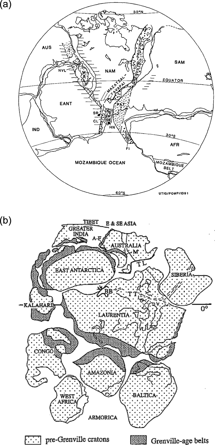
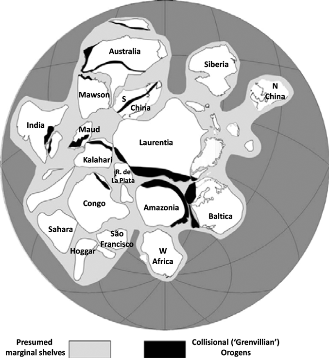
Motivated by reading of a correlation between the Neoproterozoic strata of western Canada and eastern Australia by Canadians Bell & Jefferson (Reference Bell and Jefferson1987) after participating in a field trip to Antarctica, Moores (Reference Moores1991) proposed the The Southwest US–East Antarctica (SWEAT) hypothesis. This juxtaposed the Pacific margins of Precambrian East Antarctica and Australia with that of western Laurentia. He pointed out in particular that the Proterozoic Yavapai and Mazatzal orogens of the southwestern United States might have continued into the long-enigmatic Shackleton Range at the head of the Weddell Sea, which trends at a high angle to the Transantarctic margin. The present author supported the SWEAT fit with a more geometrically accurate reconstruction with regard to scale (Dalziel Reference Dalziel1991; Fig. 2a), and suggested that the Grenville orogen of eastern and southern Laurentia might have continued into Coats Land to the immediate north of the Shackleton Range, where poorly exposed igneous rocks had been dated at ca. 1·0 Ga. Aware of palaeomagnetic data that indicated East and West Gondwana did not join until the end of the Precambrian or the earliest Palaeozoic, It was also suggested that Laurentia might have been located between the two, with the proto-Andean margin of South America juxtaposed with the proto-Appalachian margin of Laurentia (Dalziel Reference Dalziel1991). Hoffman (Reference Hoffman1991), presenting a similar reconstruction, suggested that the opening of the Pacific Ocean basin might indeed have turned Gondwana “inside out”, with the various cratons of East and West Gondwana amalgamating as they rifted and drifted from their positions juxtaposed with the Laurentian margins (Fig. 2b). He also made the critical observation that the Sunsas orogen of present-day western Amazonia might be the counterpart to the Grenville orogen along the eastern seaboard of Laurentia. This will be discussed further in section 4.
Figure 2 (a) Rodinia reconstruction of Dalziel (Reference Dalziel1991) based partly on the “SWEAT” fit of Moores (Reference Moores1991) for juxtaposition of Laurentia and East Antarctica–Australia and placing Laurentia between East and West Gondwana. Horizontal lines=Late Precambrian continental margins; dotted line=Grenvillian orogens; diagonal lines=Yavapai and Mazatzal orogens; short multidirectional dashes=accreted since late Precambrian breakup. Abbreviations: AFR=Africa; AUS=Australia; CL=Coats Land; EANT=East Antarctica; EWM=Ellsworth–Whitmore Mountains crustal block; FI=Falkland Islands/Lafonian microplate; HN=Haag Nunataks; IND=India; MBL=Marie Byrd Land; NAM=North America; NVL=North Victoria Land; PAT=Patagonia; SAM=South America; SR=Shackleton Range; T=Tasman orogen. (b) Rodinia reconstruction of Hoffman (Reference Hoffman1991) as redrawn by Li et al. (Reference Li, Zhang and Powell1995). Abbreviations: A–F=Albany–Fraser mobile belt; BB=Belt basin; M=Musgrave block; TL=Tasman line; TT=Thelon–Talston zone.
2.2. Alternatives to SWEAT
Alternative hypotheses to the SWEAT fit of the Pacific margins of East Antarctica–Australia and Laurentia have been proposed. They fall in four categories: (1) insertion of an intervening craton; (2) lateral offset of the two margins; (3) juxtaposition of a different craton with the proto-Pacific margin of Laurentia; and (4) radically different. They will be briefly described and discussed here, but the reader is referred to the articles cited for illustrations.
2.2.1. An intervening craton?
Li et al. (Reference Li, Zhang and Powell1995) suggested that the South China block was located between East Antarctica–Australia and Laurentia prior to the opening of the Pacific Ocean basin. This was primarily based on a suture zone they identified as being of Grenvillian age between the western Yangtze craton and eastern Cathaysian block. This palaeogeographic interpretation is incorporated into the ‘consensus’ Rodinia reconstruction agreed upon by the members of the International Geoscience Project #440 (Li et al. Reference Li, Bogdanova, Collins, Davidson, De Waele, Ernst, Fitzsimons, Fuck, Gladkochub, Jacobs, Karlstrom, Lul, Natapov, Pease, Pisarevsky, Thrane and Vernikovsky2008; Fig. 3).
Figure 3 ‘Consensus Rodinia’ reconstruction of Li et al. (Reference Li, Bogdanova, Collins, Davidson, De Waele, Ernst, Fitzsimons, Fuck, Gladkochub, Jacobs, Karlstrom, Lul, Natapov, Pease, Pisarevsky, Thrane and Vernikovsky2008) resulting from International Geosciences Programme Project #440.
However, the orogenic belt between the two basement blocks has now been identified as younger than Grenvillian (Zhao et al. Reference Zhao, Zhou, Yan, Zheng and Li2011), and the South China block reinterpreted on the basis of palaeomagnetic data as marginal to Rodinia rather than internal to the supercontinent (Yang et al. Reference Yang, Sun, Yang and Pei2004). Boger (Reference Boger2010) proposed the intervention of a ‘Beardmore–Curnamona “microcontinent” between East–Antarctica and Australia, apparently based on the distinction between the comparatively small Curnamona crustal block and the Gawler portion of the Mawson craton in Australia across a shear zone. However, he acknowledges that the boundaries of the block are unknown and, despite being depicted as approximately the size of Laurentia, all but the Curnamona block itself and a small supposedly continuous block in the central Transantarctic Mountains ‘disappear’ from his reconstructions after 580 Ma. Hence there seems to be no compelling case for a craton intervening between East Antarctica–Australia and Laurentia, especially if they were part of the same large craton until sometime in the Neoproterozoic, as discussed in section 3.
2.2.2. Lateral offset of the margins?
Various modifications of the SWEAT ‘fit’ of the East Antarctica–Australia and Laurentian margins involving limited lateral offsets have been suggested over the past two decades on the basis of detrital zircon populations (Ross et al. Reference Ross, Parrish and Winston1992), isotope geochemistry of basement rocks (Borg & De Paolo Reference Borg and DePaolo1994) and the age and geochemistry of igneous rocks (Goodge et al. Reference Goodge, Williams and Myrow2004). Several authors have suggested that the East Antarctic–Australian and Laurentian margins were indeed juxtaposed, but with major offsets, despite being equivalent in length. Karlstrom et al. (Reference Karlstrom, Harlan, Williams, McLelland, Geissman and Ahall1999) and Burrett & Berry (Reference Burrett and Berry2000) argue for a continuation of the Proterozoic orogens of southwestern Laurentia into southeastern Australia, a so-called AUS–WUS connection. Wingate et al. (Reference Wingate, Pisarevsky and Evans2002) point to a discrepancy between palaeomagnetic poles in Laurentia and western Australia and suggest that if a connection existed, it was between eastern Australia and Mexico, AUS–MEX. The difficulty with these reconstructions for the present author is that they leave thousands of kilometres of late Precambrian rifted margin in both Laurentia and East Antarctica with no juxtaposed craton. Moreover, given the limited ‘budget’ of late Precambrian rifted margins, these reconstructions seem to leave leave insufficient candidates for juxtaposition with the thousands of kilometres of widely accepted late Precambrian rifted margins of Laurentia and East Antarctica, even allowing for the destruction of some through subsequent subduction. There also seems to be some doubt about the relevance of the high-quality palaeomagnetic pole used from Western Australia, given the uncertain relation of the collection locality to the proto-Pacific margin craton or cratons.
2.2.3. Siberia–western Laurentia juxtaposition?
Sears & Price (Reference Sears and Price2003) have proposed, on several lines of evidence, that the Siberian craton was juxtaposed with the Pacific margin of Laurentia. However, this also would leave a large part of the length of the Laurentian Pacific margin and all of the East Antarctica–Australia margin with no obvious counterpart. Moreover, new palaeomagnetic data indicate that Siberia was located off the Arctic margin of Laurentia, as earlier proposed by several authors (Evans & Mitchell Reference Evans and Mitchell2011).
2.2.4. Radical alternatives
Evans (Reference Evans, Murphy, Keppie and Hynes2009) proposed a palaeomagnetically-based Rodinia model that is a radical departure from ‘standard models’ that generally place fragments of eastern Gondwana (East Antarctica, Australia, India) off the Pacific margin of Laurentia and fragments of western Gondwana (Africa, South America) off its proto-Appalachian/Grenvillian margin (Fig. 2). Rather, Evans' analysis leads him to place Amazonia, Rio de la Plata and West Africa off Laurentia's Pacific margin, the Congo craton off its Arctic margin and East Antarctica, Australia and Kalahari at some distance off the Greenland margin. Only Baltica is left in a more ‘standard’ position off Greenland. There is no counterpart to the proto-Appalachian margin, and he suggests this may be due to the difficulty in recognising a former ‘strip continent’ such as the Lomonosov Ridge and Lord Howe Rise/Zealandia. However, although he claims that this model permits a reasonable kinematic path to the well established assembly of Pangaea by the end of the Palaeozoic, the present author has difficulty in seeing this. This model is quite incompatible with the geologic relationships described below in section 3, most notably: the geochemical and geochronologic similarities of the Laurentian craton and the Precambrian rocks along the Transantarctic margin of East Antarctica and southeastern Australia (the Mawson craton, see sections 3·1 and 3·2); recognition of the rocks of Coats Land block as a likely continuation of the Keeweenawan province of Laurentia (section 3·1); and the evidence of tectonic interaction between the proto-Appalachian margin of Laurentia and the proto-Andean margin of Gondwana from Grenvillian through Palaeozoic times (section 4). Clearly, there is still a major discrepancy between some of the palaeomagnetic data and the geologic evidence, at least as interpreted here.
3. Testing East Antarctica–Laurentia juxtaposition and fit
In the two decades since publication of the SWEAT hypothesis, it has become clear that several of the cratonic entities considered in the original papers of Moores (Reference Moores1991), Dalziel (Reference Dalziel1991) and Hoffman (Reference Hoffman1991) may not have existed by the time of closure of Grenvillian sutures at ca. 1·0 Ga. This includes East Antarctica itself, let alone ‘East Gondwana’ as a whole (East Antarctica–Australia–India; Fig. 2). Laurentia was unaffected by orogenesis in the age range of 0·7–0·45 Ga that is widespread in the Gondwana continents and termed Pan-African by Kennedy (Reference Kennedy1964), and the extent to which these Pan-African orogens represent ocean basin closure is still debated (Boyd et al. Reference Boyd, Nordgulen, Thomas, Bingen, Bjerkgård, Grenne, Henderson, Melezhik, Often, Sandstad, Solli, Tveten, Viola, Key, Smith, Gonzalez, Hollick, Jacobs, Jamal, Motuza, Bauer, Daudi, Feitio, Manhica, Moniz and Rosse2010). Shackleton (Reference Shackleton1976) stated: “no convincing ophiolite or sutures have been recognized within the Pan-African domains,” and concluded that: “In situ deformation rather than collision orogeny seems probable.” It is no longer valid to say that there are no convincing ophiolites or sutures, though some belts of high grade metamorphism and ductile deformation are still problematic with regard to whether or not they represent the site of a former ocean basin (e.g. Key et al. Reference Key, Pitfield, Thomas, Goodenough, Waele, Schofield, Bauer, Horstwood, Styles, Conrad, Encarnacion, Lidke, O'connor, Potter, Smith, Walsh, Ralison, Randriamananjara, Rafahatelo, Rabarimanana, Van Hinsbergen, Buiter, Torsvik, Gaina and Webb2011).
In the case of East Antarctica, it is impossible to even trace Pan-African belts confidently across this “keypiece” of the Gondwana craton, because only its fringes are exposed. Nonetheless, ultramafic rocks in the Shackleton Range, for example, appear to mark a Pan-African suture (Schmädicke & Will Reference Schmädicke and Will2006; Romer et al. Reference Romer, Mezger and Scmädicke2009), trending at a high angle to the Transantarctic margin, that probably crosses the continent to the Indian Ocean margin. While it is currently impossible to tell how far it extends under the ice toward the interior of East Antarctica, there is mounting geochronological and geochemical evidence that the Gawler craton of southeastern Australia, the rocks of Terre Adélie and King George Land along the Wilkes Land coast along the opposed margin of East Antarctica, the Miller Range of the central Transantarctic Mountains and the Read Mountains of the southern Shacketon Range are all part of a single craton. This has been termed the Mawson craton after the great Australian Antarctic explorer and geologist (Fanning et al. Reference Fanning, Moore, Bennett, Daly and Kennard1996; Will et al. Reference Will, Zeh, Gerdes, Frimmel, Millar and Schmädicke2009). This means that the concept that there was a single Neoproterozoic rift along approximately 4000 km of the East Antarctic–Australian margin is still valid, even if the extent of the rifted craton under the East Antarctic Ice Sheet is uncertain.
Palaeomagnetism is recognised as the only quantitative tool for establishing the palaeogeographic relationships of different continental entities prior to the amalgamation of Pangaea in the late Palaeozoic. Nonetheless, given the absence of palaeolongitudinal control and the difficulty of obtaining high quality, well dated poles for Palaeozoic and Precambrian rocks, the palaeomagnetic method alone is unlikely to lead to completely satisfactory reconstructions of the Earth's pre-Pangaea geography. Equally, with similar and contemporaneous geologic processes frequently active on different cratons, correlation of coeval lithotectonic units is also unsuitable for uniquely identifying palaeogeographic relationships. However, even comparatively small geologic provinces or terranes can have characteristics distinctive enough to provide valuable constraints. The key here is identifying these distinctive geologic characteristics, matching them between two now separate cratons, provinces or terranes and, where possible, confirming the match with key palaeomagnetic poles.
One example is the Hebridean terrane of northwest Scotland whose Cambrian–Ordovician Olenellid benthic trilobite fauna and strata were recognised by Salter (Reference Salter1859) and Peach et al. (Reference Peach, Horne, Gunn, Clough, Hinxman and Teal1907) as distinctively North American. Marine and satellite geophysical studies of the North Atlantic Ocean basin subsequently made it clear that the Hebridean terrane was indeed once part of Laurentia, the ancestral core of the North American continent. This small terrane can therefore be regarded as a ‘tectonic tracer’ for Laurentia sensu Dalziel (Reference Dalziel1993); it provided a significant clue to Pangaea reconstruction prior to knowledge of the nature and age of the intervening ocean basin. The Cuyania terrane of northwest Argentina also contains the Olenellid trilobite fauna. Together with stratigraphic correlation, the age and the Pb isotope characteristics of its basement rocks, and its high quality palaeomagnetic data, also point to a Laurentian origin. As discussed in section 4, the Cuyania terrane provides a clear clue to the relationship of Laurentia and the proto-Andean margin of Gondwanaland during Ordovician times (section 5; see Dalziel Reference Dalziel1997 and Reference Dalziel, Butler, Holdsworth, Krabbendam, Law and Strahan2010 for reviews).
Obviously, no faunal evidence exists with which to correlate Precambrian cratonic entities. However, there are two particularly distinctive igneous suites in southwestern Laurentia that can provide clues as to the craton or cratons formerly juxtaposed with its Pacific margin. These are the ca. 1·4-Ga anorogenic granite suite and the 1·1-Ga mafic and less common felsic rocks associated with the mid-continent rift system, the Keeweenawan large igneous province (LIP). Both have now been discovered along the Pacific margin of East Antarctica, though separated by the Pan-African suture through the Shackleton Range. At least one clast of the anorogenic granite suite has been found in a moraine on the Mawson craton and must have been derived from beneath the ice sheet, and felsic rocks of Keeweenawan age and distinctive geochemistry occur in the small Coats Land crustal block immediately to the east of the Shackleton Range suture (Fig. 4).
Figure 4 Palaeogeographic relations of Laurentia and East Antarctica–Australia prior to opening of the Pacific Ocean basin during the Neoproterozoic according to Goodge et al. (Reference Goodge, Williams and Myrow2004, Reference Goodge, Vervoort, Fanning, Brecke, Farmer, Williams, Myrow and DePaolo2008), with geologic provinces and geochronological and geochemical characteristics common to the two cratons. The following have been added by the present author to illustrate the discussion in the text (section 3·1): 1 – The possible extension of the Mawson craton to the southern Shackleton Range (red line with question marks to indicate uncertainty in inland boundary); 2 – The approximate location and extent of the Curnamona craton (gold); 3 – The location of the Coats Land block of East Antarctica and the Franklin Mountains of west Texas; and 4 – The location of the East Antarctic Grunehogna block of the Kalahari craton. Abbreviations: C=Curnamona craton; CL=Coats Land; EAO/M=East African orogen/Mozambique orogen; FM=Franklin Mountains; G=Gawler craton; GSM=Gamburtsev Subglacial Mountains; G=Grunehogna block; Mo=Mojavia; MR=Miller Range; PM=Pensacola Mountains; Pr=Prichard Formation; R=Ross (Antarctica)/Delamerian (Australia) orogen; SR=Shackleton Range; TA=Terre Adelie.
3.1. Juxtaposition
Goodge et al. (Reference Goodge, Vervoort, Fanning, Brecke, Farmer, Williams, Myrow and DePaolo2008) found a glacial clast of A-type granite in a moraine along the Transantarctic margin of the East Antarctic craton that has a uranium-lead zircon age of ∼1440 Ma, an █-hafnium initial value of +7, and █-neodymium value of +4. These data indicate the presence in the Mawson craton area of East Antarctica of granites having the same age, geochemical properties and isotopic signatures as the highly distinctive A-type granites of Laurentia. Granites of this type and age are known in situ only from Laurentia and Baltica. In addition, they report that the neodymium isotopes of Neoproterozoic rift-margin strata along the Mawson craton and Laurentian Pacific margins are similar, and that the hafnium isotopes of 1·4 Ga Antarctic-margin detrital zircons match those in Laurentian granites of similar age (Fig. 4). They therefore regard their study as representing “A positive test of East Antarctica–Laurentia juxtaposition within the Rodinia supercontinent.”
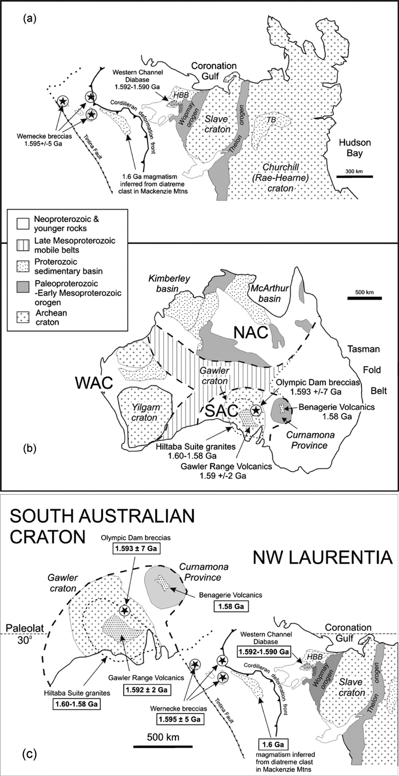
Supporting this evidence for juxtaposition of the Mawson and Laurentian cratons is the correlation of the coeval 1·59-Ga Olympic Dam and Wernecke breccias in the Gawler craton of South Australia and the Wernecke inlier of the Yukon respectively (Thorkelson et al. Reference Thorkelson, Mortensen, Davidson, Creaser, Perez and Abbott2001; Hamilton & Buchan Reference Hamilton and Buchan2010; Fig. 5). Apart from their contemporeneity at locations along the Pacific margin, there are remarkable similarities between these unusual mineralised breccia provinces (Corriveau Reference Corriveau2008).
Figure 5 Correlation by Hamilton & Buchan (Reference Hamilton and Buchan2010) following Thorkelson et al. (Reference Thorkelson, Mortensen, Davidson, Creaser, Perez and Abbott2001) of the Wernecke breccias of northwestern Laurentia (1·595+/−5 Ga) with the Olympic Dam breccias of southern Australia (1·59+/−2 Ga): (a) Ca. 1·59 Ga rocks in the Wernecke inlier and Wopmay orogen of northwestern Laurentia; (b) the Gawler craton and Curnamona block of the South Australia craton. Abbreviations: HBB=Hornby Bay basin; NAC=North Australian Craton; SAC =South Australian Craton; TB=Thelon basin; WAC=West Australian Craton; (c) South Australian Craton reconstructed to northwestern Laurentia based on the closest palaeomagnetic fit and the assumption that the Gawler Range palaeopole is primary.
The small Coats Land block (Fig. 4), identified by Dalziel (Reference Dalziel1991) on the basis of the then existing geochronometric data as a possible continuation of the Grenville orogen of Laurentia, is now recognised as a geologically distinct and geophysically defined crustal entity within East Antarctica (Gose et al. Reference Gose, Helper, Connelly, Hutson and Dalziel1997; Studinger & Miller Reference Studinger and Miller1999; Kleinschmidt & Boger Reference Kleinschmidt and Boger2009). Bertrab and Littlewood nunataks at Vahsel Bay, the only two accessible outcrops in Coats Land, are composed of undeformed rhyolites and granophyres with a U–Pb zircon age of 1112+/−4 Ma (Gose et al. Reference Gose, Helper, Connelly, Hutson and Dalziel1997). Felsic magmatism in Coats Land occurred at the same time as emplacement of the 1112–1106-Ma Umkondo LIP in the Kalahari craton of southern Africa (Hanson et al. Reference Hanson, Crowley, Bowring, Ramezani, Gose, Dalziel, Pancake, Seidel, Blenkinsop and Mukwakwami2004). The Umkondo LIP comprises widespread diabase intrusions, basaltic lavas and locally abundant felsic igneous rocks (Hanson et al. Reference Hanson, Crowley, Bowring, Ramezani, Gose, Dalziel, Pancake, Seidel, Blenkinsop and Mukwakwami2004). Equivalents of the Umkondo LIP have been identified in East Antarctica in the Grunehogna terrane (Fig. 4), which remained part of Kalahari until the Mesozoic break up of Gondwana (Jacobs et al. Reference Jacobs, Pisarevsky, Thomas and Becker2008). Although marine and satellite data demonstrate that Coats Land was close to Kalahari within the Gondwana supercontinent, the Coats Land rocks yield Pb isotope compositions strikingly distinct from those of the Umkondo province, yet indistinguishable from rocks of the Keweenawan province (Loewy et al. Reference Loewy, Dalziel, Pisarevsky, Connelly, Tait, Hanson and Bullen2011). The anorogenic Red Bluff granitic suite, along the present-day southern Laurentian margin in the Franklin Mountains (Fig. 4), is of comparable age, general rock-type and Pb-isotope composition to rocks of Coats Land, and may provide a piercing point for a Coats Land–Laurentia link by means of a large igneous province. Palaeomagnetic poles permit the Coats Land block to lie close to this part of Laurentia at ca. 1100 Ma, as pointed out by Jacobs et al. (Reference Jacobs, Pisarevsky, Thomas and Becker2008).
Thus, the evidence that the Pacific margin of East Antarctica rifted from the Pacific margin of Laurentia in the initiation of the Pacific Ocean basin is mounting. However, with evidence from Coats Land and the Pan-African suture through the Shackleton Range, the relationship between the margins is more complex than envisaged in the SWEAT hypothesis (Fig. 2). The Mawson craton was juxtaposed with the proto-Cordilleran margin of Laurentia, but the Coats Land block, separated from the Mawson craton by the suture in the Shackleton Range, appears to have been attached to the present southern tip of Laurentia off west Texas, and to have been united with the Mawson craton during a Pan-African collisional event through the present Shackleton Range, after the latter separated from Laurentia during the Neoproterozoic to open the Pacific Ocean basin. Moreover, the Mawson craton is now recognised as extending along the Transantarctic margin as far as the southern part of the Shackleton Range. Hence, the basement correlation between the Mojavia province of southwestern Laurentia and the Miller Range of the central Transantarctic Mountains assumed by Borg & DePaolo (Reference Borg and DePaolo1994) and by Goodge et al. (Reference Goodge, Vervoort, Fanning, Brecke, Farmer, Williams, Myrow and DePaolo2008) and shown in Figure 4 is open for reevaluation, especially as it leaves ca. 1500 km of the rifted margins of both East Antarctica and Laurentia without counterparts.
3.2. Fit
As shown in Figure 2 and discussed in section 2, the Neoproterozoic Pacific margins of East Australia–Antarctica and Laurentia are of very similar length (Dalziel Reference Dalziel1991). Nonetheless, Borg & DePaolo (Reference Borg and DePaolo1994) and Goodge et al. (Reference Goodge, Vervoort, Fanning, Brecke, Farmer, Williams, Myrow and DePaolo2008) suggested considerable offset of these margins to account for the distribution of basement radiometric age and isotopic provinces (Fig. 4). Most critically, the presence of basement rocks of southwestern Laurentian characteristics in the central Transantarctic Mountains led to their reconstructions that leave over 1500 km of the rifted margin of the Mawson craton (Miller Range to the Shackleton Range, Fig. 4) with no obvious counterpart. However, the basement rocks of the Shackleton Range also have a history and chemistry comparable to that of parts of southwestern Laurentia, though not entirely as envisaged by Moores (Reference Moores1991) in his ‘SWEAT’ hypothesis..
The rocks of the Read Mountains of the southern Shackleton Range are mainly characterised by Archaean Nd signatures (Will et al. Reference Will, Frimmel, Zeh, Le Roux and Schmädicke2010; Fig. 6b) and contain zircons that are at least as old as Palaeoproterozoic. They experienced a major late Palaeoproterozoic (ca. 1·8 Ga) orogenic event that was accompanied by upper amphibolite to granulite facies metamorphism (Will et al. Reference Will, Zeh, Gerdes, Frimmel, Millar and Schmädicke2009).
Figure 6 (a) Location of the Mojavia province (M – indicated by arrow) on a map showing the distribution of Nd-model age provinces in Laurentia; the dashed curve adjacent to Mojavia is the inferred location of a Proterozoic shear (from Bennett & DePaolo Reference Bennett and DePaolo1987). Abbreviations: Gr=Grenville orogen; Mz=Mazatzal orogen; Y=Yavapai orogen. (b) Initial █Nd versus crystallisation age of rocks from the Shackleton Range (red lines) and Miller Range (blue) of the Mawson craton, Antarctica, superimposed on the fields for the Nd-model age provinces of the southwestern United States (Bennett & DePaolo Reference Bennett and DePaolo1987; Rämö & Calzia Reference Rämö and Calzia1998; see Fig. 6a. Fields 1 & 1* – Mojavia province (2·0–2·3 Ga); Field 2 – Yavapai orogen (1·8–2·0 Ga); Field 3 – Mazatzal orogen (1·7–1·8 Ga). See text for discussion.
Moores (Reference Moores1991) proposed in the initial paper on the ‘SWEAT connection’ that the rocks of the Shackleton Range might be a continuation of the Yavapai and Mazatzal provinces of the southwestern United States. The geochemical characteristics of the Read Mountain basement, however, indicate that of all the southwest United States Nd isotopic provinces, they look most like the Mojavia province, which separates the Yavapai province from the ancient cratonic margin (Fig. 6a). There appears to be an increase in the older crustal component of the Mojave crust in a present-day westerly direction (Rämö & Calzia Reference Rämö and Calzia1998; Fig. 6b), and the westward increase in model Nd ages may reflect the presence of an Archaean block. To date, no ca.1·4-Ga anorogenic granites have been found in the Shackleton Range (see discussion below).
It is notable that this fit is geometrically compatible with the conclusion of Thorkelson et al. (Reference Thorkelson, Mortensen, Davidson, Creaser, Perez and Abbott2001) that the 1·59-Ga Wernecke breccias of the northern Yukon, Canada may be the equivalents of the mineralised breccias of the Olympic Dam deposit of the Gawler craton and adjacent Curnamona Province of South Australia. Palaeomagnetic data from a large 1·59-Ga magmatic province in the Northwest Territories of Canada and the 1·93-Ga Gawler Range Volcanics of South Australia are permissive of this correlation (Hamilton & Buchan Reference Hamilton and Buchan2010; Fig. 5b & 7). This fit is essentially that shown by Payne et al. (Reference Payne, Hand, Barovich, Reid, Evans, Reddy, Mazumder, Evans and Collins2009) for Laurentia and the Mawson craton from the central Transantarctic Mountains to the Gawler craton.
Figure 7 ‘Diachronous reconstruction’ of core elements of the Rodinia supercontinent through the initial opening of the Pacific Ocean basin (ca. 700–550 Ma), shown in present-day North American coordinates. Present-day continental outlines are shown as ‘shadows.’ Triangles show localities on the greater Mawson craton (Australia and East Antarctica) and the Coats Land crustal block (East Antarctica) suggested as ‘piercing points’ with the Laurentian craton; designation ‘1’ for a locality indicates position relative to Laurentia at ca. 700 Ma, and ‘2’ indicates position relative to Laurentia at ca. 550 Ma – see text for discussion. Localities: C=Coats Land igneous province of Antarctica; F=Franklin Mountains in Laurentia, SW end of suggested correlative Keeweenawan large igneous province; MJ=suggested correlative Mojavia province of Laurentia); MR=Miller Range basement of central Transantarctic Mountains; OD=Olympic Dam breccias of Australia; SR=Read Mountains of Shackleton Range; W=suggested correlative Wernecke inlier in Laurentia; WY=suggested correlative Wyoming province of Laurentia.
The initial position of the greater Mawson craton (Mawson craton in Antarctica, MAW 1, plus Gawler craton of Australia, GL1, and including the adjacent Curnamona block), juxtaposed with the Pacific margin of Laurentia, shows the core of Rodinia at ca. 1·0 Ga, following the Grenvillian suturing of South American parts of west Gondwana against the proto-Iapetan margin of Laurentia (following Ramos Reference Ramos2010), and of the greater Kalahari craton (i.e. including the Grunehogna crustal block of Antarctica) against present southernmost Laurentia (Loewy et al. Reference Loewy, Dalziel, Pisarevsky, Connelly, Tait, Hanson and Bullen2011). Palaeomagnetic poles for the Western Channel diabases of Laurentia (wcd) and the Gawler Range volcanic (grv) at ca. 1·6 Ga (assuming magnetisation to be primary) are shown with their alpha 95 circle of confidence (Hamilton & Buchan Reference Hamilton and Buchan2010; see discussion in text). There is some overlap of the Mawson craton (MAW 1) with Mojavia, as the proto-Pacific margins cannot now be restored accurately as east–west Basin and Range extension in the SW United States is estimated at a mean of 100% across 800 km. Also, the greater Kalahari craton (core, K, plus Grenvillian/Kibaran belts) is showing total overlap with Patagonia, which is believed to be allochthonous (Ramos Reference Ramos2008, Reference Ramos2010) or subsequently accreted. Note that the reconstruction of Loewy et al. (Reference Loewy, Dalziel, Pisarevsky, Connelly, Tait, Hanson and Bullen2011) for Coats Land and Kalahari with respect to Laurentia is compatible with that of Cawood et al. (Reference Cawood, Strachan, Cutts, Kinny, Hand and Pisarevsky2010) for Baltica with respect to Laurentia with the intervening Neoproterozoic Valhalla orogen (VO). Dashed line=presumed continuation of Texan Laurentia to the Coats Land crustal block (actual extent unknown, may be basement to part of northern Mexico).
The final position of the greater Mawson craton (MAW2 plus GL2 and adjacent Curnamona block) shows its position at the end of Precambrian times following suturing with the Coats Land block of Texan Laurentia along the Pan-African suture (PAO) exposed in the Shackleton Range of Antarctica (a presumed continuation of the East African orogen). This reconstruction reflects the incipient completion of the Gondwana supercontinent by closure of Pan-African orogens. The hypothetical ‘Pannotia’ supercontinent comprises Laurentia and amalgamating Gondwana, and would have existed prior to the opening of the Iapetus Ocean basin between proto-Appalachian Laurentia and proto-Andean South America.
Laurentian orogens, provinces and boundaries: G–R=Grenville front, northwestern boundary of Grenville province (grey); H=Hearne province; M=Mazatzal orogen; MJ=Mojavia province; P=Penokean orogen; R=Rae province; SL=Slave craton; SUP=Superior; T–H=Trans-Hudson orogen; TO=Talston orogen; W=Wernecke inlier; WP=Wopmay orogen; Y=Yavapai orogen (B=Baffin Island and GRN=Greenland).
Kalahari craton (red, K) with green Namaqua–Natal Maud or ogen (Loewy et al. Reference Loewy, Dalziel, Pisarevsky, Connelly, Tait, Hanson and Bullen2011).
Cratonic South America: AM=Amazonian craton; WP=Western Pampianas terrane; crosses indicate ‘autochthonous’ Grenvillian orogens of South America (Ramos Reference Ramos2010).
Other terranes of South America are shown in present-day positions as ages of sutures are unclear: CDP=Cuchilla Dionisio–Pelotas terrane; LA=Luis Alvez craton; P=Paraná terrane; RA=Rio Apa; RP=Rio de la Plata; SF=Säo Francisco craton.
Allochthonous and exotic terranes of Laurentia and South America with Grenvillian basement: AF=Antofalla terrane; AQ=Arequipa terrane; CU=Cuyania terrane (restored to Ouachita embayment of Laurentia); EP=Eastern Pampianas terrane; F=Famatina terrane; O=Oaxaquia terrane of Mexico (restored to South American margin after Ramos Reference Ramos2010).
BAL=Baltica (positioned as in Cawood et al. Reference Cawood, Strachan, Cutts, Kinny, Hand and Pisarevsky2010 after 1·0 Ga).
Given the extent of the Mojavia province along approximately 1000 km of the Pacific margin of Laurentia, it seems quite reasonable to reconstruct East Antarctica–Australia juxtaposed with the Mojavia province opposite the Mawson craton in the vicinity of the Shackleton Range, thus satisfying the geometry of the rifted margins as well as the geochronological and geochemical signatures. Moreover, the Nd signature of the Miller Range is more like that of the Wyoming craton than the Mojavia province (Fig. 6b). Both have model Nd crustal residence ages exceeding 2·5 Ga rocks (Borg & De Paolo Reference Borg and DePaolo1994: Frost Reference Frost1993). Goodge & Fanning (Reference Goodge and Fanning1999) and Goodge et al. (Reference Goodge, Fanning and Bennett2001) pointed out that orthogneisses of the Nimrod Group in the Miller Range have an Archaean igneous protolith, the only known Archaean crust of the Transantarctic Mountains margin of the East Antarctic craton. Restoration of the Miller Range opposite the Wyoming craton therefore provides a third ‘piercing point’ along the juxtaposed East Antarctic–Australian and Laurentian margins, the correlation points being spread out along the entire length of the matched ca. 4000-km rifted margins (Fig. 7).
An outstanding puzzle with regard to Laurentia–greater Mawson craton reconstruction, lies in the fact that so few examples of the ca. 1·4-Ga anorogenic granites so common in southwestern Laurentia have been found in East Antarctica, and then only as clasts in moraines in the central Transantarctic Mountains. With the reconstruction shown in Figure 7, they would be expected in or near the Shackleton Range. However, the older rocks of the Shackleton Range are found in the Read Mountains that cover only ∼25 km×8 km. They are separated by over 1500 km from the Miller Range and no attempts have been made to find additional detrital samples in moraines between these outcrops. Moreover, the catchment basins from which the glacial clasts were derived are very large, and the exact location of the body or bodies of anorogenic granite of course remains unknown.
The undeformed rhyolitic rocks of the Coats Land block, with the same age and Pb isotope signature as the Keeweenawan LIP, were most likely erupted northwest of the Grenville front in a continuation of the ca. 1·1-Ga mid-continent rift system. Palaeomagnetic data permit reconstruction in a position close to the present southwestern extremity of the rift in the Franklin Mountains just north of El Paso, Texas (Loewy et al. Reference Loewy, Dalziel, Pisarevsky, Connelly, Tait, Hanson and Bullen2011; Fig. 7). If identification of the Coats Land block as a Laurentian fragment and reconstruction close to the Franklin Mountains are correct, then Laurentia collided with the Kalahari craton at ca. 1·0 Ga, and the intervening Namaqua–Natal–Maud orogen was a continuation of the Grenvillian orogen of eastern and southern Laurentia (Loewy et al. Reference Loewy, Dalziel, Pisarevsky, Connelly, Tait, Hanson and Bullen2011, fig. 3). Thus, the Mawson craton and the Coats Land block formed part of Rodinia, together with Laurentia and Kalahari, prior to the opening of the Pacific Ocean basin and a Pan-African suturing event between them.
4. The proto-Appalachian and Arctic margins of Laurentia: how extensive was Rodinia?
Early ideas regarding the reconstruction of the Rodinian supercontinent took into account both the similar lengths of the proto-Appalachian and proto-Andean late Precambrian rifted margins of Laurentia and West Gondwana (Dalziel Reference Dalziel1991; Fig. 2a), and the presence of the Grenvillian-age Sunsas belt along the present-day western margin of Amazonia (Hoffman Reference Hoffman1991; Fig. 2b). The proto-Andean margin is, however, much more difficult to discern than its Laurentian counterpart, probably due to a tectonically-convergent history of over 500 My. Moreover, West Gondwana has a network of Pan-African orogenic belts, and it is not everywhere clear when its different cratons and other crustal blocks were sutured together. Nonetheless, it has become clear over the past several years that a Grenvillian age is common to the basement of many of the lithospheric fragments along the proto-Andean margin. Thus, the reconstructions in Figure 2 may indeed be close to providing a reasonably accurate, if greatly over-simplified, picture of the Laurentian craton as the core of Rodinia, sandwiched between parts of what became East and West Gondwana before it ‘broke out’ with the opening of, first, the Pacific Ocean basin during the Neoproterozoic, and then the Iapetus Ocean basin in the latest Precambrian to earliest Palaeozoic. The Grenville orogen seems to be represented today by the type Grenville of Laurentia, and by autochthonos belts along the Andean margins of Amazonia (the Sunsas belt) and western Sierras Pampeanas, and by various terranes with their origin on either side of Iapetus, sometimes having been subsequently “exchanged” across that ocean basin (Ramos Reference Ramos2010), notably the Cuyania terrane of northwest Argentina and the Grenvillian basement of the southern Appalachians (see also section 5).
This Grenvillian belt that resulted from collision between proto-Appalachian Laurentia and several individual fragments of what became West Gondwana continued into the Namaqua–Natal–Maud belt along the margin of the Kalahari craton opposed to Laurentia, including the Coats Land crustal block (Loewy et al. Reference Loewy, Dalziel, Pisarevsky, Connelly, Tait, Hanson and Bullen2011; Fig. 7). It also apparently continued into Baltica across the present southern margin of the Rockall Plateau. In Figure 7, Baltica is shown in the post-1·0 Ga position of Cawood et al. (Reference Cawood, Strachan, Cutts, Kinny, Hand and Pisarevsky2010). It is notable that the Loewy et al. (Reference Loewy, Dalziel, Pisarevsky, Connelly, Tait, Hanson and Bullen2011) and Cawood et al. (Reference Cawood, Strachan, Cutts, Kinny, Hand and Pisarevsky2010) reconstructions of Laurentia–Kalhari and Laurentia–Baltica respectively, following the Grenvillian orogeny, are compatible if the allochthonous nature of Patagonia is accepted (Ramos Reference Ramos2008), or if the Patagonian basement was accreted to the Pacific margin of Antarctica like that of West Antarctica.
The full extent of the Rodinian supercontinent is unclear at this time. The present author argued for the inclusion of the following: Laurentia; the greater Mawson craton; the Kalahari craton that was accreted along Grenvillian/Kibaran orogens; western Pampeanas; Amazonia; Grenvillian terranes along the interface of Laurentia and West Gondwana and Baltica. Siberia apparently broke away from the Arctic margin of Laurentia prior to the Grenvillian orogeny (Evans & Mitchell Reference Evans and Mitchell2011), and was therefore never part of the Rodinia assembly. Only with better data on the time of suturing along the Pan-African orogens will we know whether or not other cratons, provinces and terranes of East and West Gondwana were amalgamated with that core prior to the opening of the Pacific Ocean basin, and hence the fragmentation of Rodinia.
5. Fragmentation of Rodinia: towards Gondwana and Pangaea in time and space
Essential to the understanding of pre-Pangaea palaeogeography are compatibility of relative continental positions through time and accordance with the amalgamation of the Gondwana supercontinent by Cambrian times and of Pangaea by the end of the Palaeozoic, without requiring excessively high rates of plate motion. The separation of the Mawson craton from the Pacific margin of Laurentia, and hence of the initial opening of the Pacific Ocean basin, seems to have taken place between 725 Ma and 660 Ma (Goodge et al. Reference Goodge, Vervoort, Fanning, Brecke, Farmer, Williams, Myrow and DePaolo2008). The Shackleton Range suture between the Mawson craton and the Coats Land block. Maud orogen and Kalahari craton reflects a collision close to the end of Precambrian times (Schmädicke & Will Reference Schmädicke and Will2006; Romer et al. Reference Romer, Mezger and Scmädicke2009; Will et al. Reference Will, Zeh, Gerdes, Frimmel, Millar and Schmädicke2009; Fig. 7). Dalziel (Reference Dalziel, Butler, Holdsworth, Krabbendam, Law and Strahan2010) demonstrated that if the rifting took place at 750 Ma and suturing at 545 Ma, the velocity of the Mawson craton relative to Laurentia need not have been in excess of measured rates of Mesozoic–Cenozoic plate motion. Rifting between 725 Ma and 660 Ma need not therefore have required an extraordinarily fast motion.
As pointed out by Loewy et al. (Reference Loewy, Dalziel, Pisarevsky, Connelly, Tait, Hanson and Bullen2011), the so-called Natal embayment between Africa and East Antarctica in Gondwana, as reconstructed using seafloor spreading data (Fig. 1b), is extremely complex tectonically. It has been the site of rigid crustal block rotation of the Falkland (Lafonian) microplate and the Ellsworth–Whitmore mountains crustal block during the Gondwana break up (Dalziel & Lawver Reference Dalziel, Lawver, Alley and Bindschadler2000), and may have been the original location of the Cuyania terrane of northwestern Argentina within or close to the Ouachita embayment of Laurentia (see Dalziel Reference Dalziel1997 and Ramos Reference Ramos2010 for reviews). Moreover, the origin of Patagonia is uncertain (Ramos Reference Ramos2008). Hence, it is impossible to make a latest Precambrian reconstruction of that area with any confidence in details. The assumption underpinning that shown in Figure 7 is that Coats Land was still attached to Laurentia until the end of the Precambrian (Loewy et al. Reference Loewy, Dalziel, Pisarevsky, Connelly, Tait, Hanson and Bullen2011).
This would mean that a supercontinental entity involving at least Laurentia, Kalahari and the Mawson craton existed briefly at that time before Laurentia rifted off. Depending on the exact timing of suturing along the many Pan-African/Brazilide orogens in the southern continents and India, it is therefore possible that this ephemeral supercontinent that has been called Pannotia could have incorporated a higher percentage of the planet's continental crust than did Rodinia. Critical additional clues to the former presence of Laurentia off the Pacific margin of Gondwana margin during the late Precambrian and early Palaeozoic are the presence of the exotic Cuyania terrane, a tectonic tracer for Laurentia, in northwestern Argentina that ‘docked’ along the Gondwana margin in mid- to late Ordovician times (Dalla Salda et al. Reference Dalla Salda, Dalziel, Cingolani and Varela1992; Thomas & Astini Reference Thomas and Astini1996; Ramos Reference Ramos2004) and the Grenvillian basement of the southern Appalachians that is a ‘tectonic tracer’ for Amazonia (Tohver et al. Reference Tohver, Bettencourt, Tosdal, Mezger, Leite and Payolla2004; Fisher et al. Reference Fisher, Loewy, Miller, Berquist, Van Schmus, Hatcher, Wooden and Fullagar2010). The rate of motion of Laurentia with respect to Gondwana during the Palaeozoic, in order to reach the position within Pangaea indicated by seafloor spreading data, need not have been higher than measured Meozoic–Cenozoic plate velocities (Dalziel Reference Dalziel, Butler, Holdsworth, Krabbendam, Law and Strahan2010). This exchange of terranes seems to indicate a narrow Iapetus Ocean basin in Ordovician times (Dalziel Reference Dalziel1997, Reference Dalziel, Butler, Holdsworth, Krabbendam, Law and Strahan2010).
6. Conclusions
In addition to being Du Toit's “keypiece” within the Gondwana supercontinent, Antarctica is critical to understanding the early Neoproterozoic supercontinent of Rodinia. It is also impotant in reconstructing the temporally intervening, loose and emphemeral supercontinetal assembly of Pannotia that seems to have existed in latest Precambrian times (Dalziel Reference Dalziel, Butler, Holdsworth, Krabbendam, Law and Strahan2010). Evidence is mounting that the greater Mawson craton extended along the present Transantarctic margin of East Antarctica–Australia from at least 1·6 Ga, and that it was juxtaposed with the Pacific margin of Laurentia. The core of Rodinia seems to have mainly comprised: Laurentia, the greater Mawson craton, Kalahari, western Pampeanas, Amazonia and Baltica. Other lithospheric entities may have amalgamated with this core prior to the opening of the Pacific Ocean basin and the fragmentation of Rodinia between 725 Ma and 660 Ma. If Laurentia was still attached to the Kalahari craton until the end of the Precambrian or earliest Cambrian, the Pannotia supercontinent may have contained a higher proportion of the contemporary continental lithosphere than Rodinia.
7. Acknowledgements
I am greatly indebted to my colleague Lisa Gahagan, Manager of the PLATES project at the Institute for Geophysics, The University of Texas at Austin, for her insightful help with creating illustrations for this contribution, not least the ‘diachronous reconstruction’ of Figure 7. Stacy Loewy of California State University Bakersfield (and now at the University of Texas at Austin) assisted by plotting and discussing the geochemical data shown on Figure 6b. Scott Borg, Carol Frost, John Goodge and Mark Helper provided insights into the basement of the central Transantarctic Mountains, the Wyoming craton and the Mojave province, but the conclusions presented here are the responsibility of the author.
The manuscript benefitted from the constructive criticisms and suggestions of Simon Harley and an anonymous reviewer. The work was supported by NSF Grant #DPP911796 to Ian Dalziel. The University of Texas, Institute for Geophysics Contribution #2421.