


In his recent call for a multidisciplinary approach, Shimada (Reference Shimada2015:2) emphasizes a holistic and integrated vision of the Inka Empire that views provincial areas with similar interest as the heartland. At the turn of the sixteenth century on the northern frontier of Ecuador, the Inka emperors sought to extend their influence and establish a new base of power (Bray Reference Bray and Shimada2015). They built a series of fortifications in the late 1400s to combat a lengthy resistance by indigenous Caranqui-Cayambe groups forming the País Caranqui, which thwarted Inka movement northward (Athens Reference Athens1978, Reference Athens, Schortman and Urban1992; Betanzos Reference Betanzos1987[1551–1557]; Bray Reference Bray1991, Reference Bray1992, Reference Bray, Silverman and Isbell2008; Cabello Valboa Reference Cabello Valboa1951[1586]; Caillavet Reference Caillavet and Caillavet2000; Cieza de León Reference Cieza de León and von Hagen1959[1553]; Cobo Reference Cobo1979[1653]; Cordero Ramos Reference Cordero Ramos1998; D'Altroy Reference D'Altroy1992, Reference D'Altroy2002; de la Vega Reference de la Vega1961; Espinosa Soriano Reference Espinosa Soriano1988; Fresco et al. Reference Fresco, Colima and Espíndola1990; Hyslop Reference Hyslop1990; Jijón y Caamaño Reference Jijón y Caamaño1952; Montesinos Reference Montesinos1957[1644], Reference Montesinos2010; Oberem et al. Reference Oberem, Wurster, Hartmann and Wentscher1969; Ogburn et al. Reference Ogburn, Connell and Gifford2009; Plaza Schuller Reference Plaza Schuller1976, Reference Plaza Schuller1977, Reference Plaza Schuller1978; Ramón Valarezo Reference Ramón Valarezo1987; Salomon Reference Salomon1986; Sarmiento de Gamboa Reference Sarmiento de Gamboa, Bauer and Smith2007[1572]). As Father Bernabé Cobo related,
The Indians of those provinces were brave and warlike, and many times the troops of the Inca were defeated and routed, and not a few times the king himself fled. Cayambes, particularly, being men of valor and courage, made it difficult for the Inca Guayna Capac and his captains that in conquering them a great deal of time and blood were lost [Reference Cobo1979(1653):157].
Situated just south of Cayambe, the Pambamarca project area reveals this story of resistance and provides strong historical context to examine imperial formations—what Lori Khatchadourian (Reference Khatchadourian2016) aptly calls the “process of becoming” in her study of satrapy in the Persian Empire (see Stoler Reference Stoler2008; Williams Reference Williams1978)—and to move beyond “testing ethnohistorical assertions to address aspects of Inka imperialism not recorded by early writers” (Shimada Reference Shimada2015:7). Work in Pambamarca is helping us understand how imperial forces and local groups reacted to and experienced tremendous change during prolonged conquest. Our expectation is that these imperial moments include militaristic displays of power and attempts at direct control incorporated with more indirect tendencies under conditions of partial sovereignty (Khatchadourian Reference Khatchadourian2016), defined by “oblique relations to formal institutions” (Williams Reference Williams1978:117; see Stoler Reference Stoler2008), through which the materialization of empire is negotiated at the level of indigenous communities. Native populations often shaped frontier dynamics because Inka control strategies were frequently in flux based on their desired wants or needs from an area (Alconini Reference Alconini2016). In Pambamarca we find evidence of different types of imperial debris: (1) constructions of three types of large impressive enclosures and roadways consistently associated with (2) direct evidence of military preparedness and conflict and (3) local settlement continuity with an Inka and Spanish overlay.
Given this palimpsest of overlapping data that cannot all be described here, this article focuses on the direct phase of imperial contact, invasion, and forceful resistance by describing archaeological investigations at two of the largest installations in Pambamarca. Evidence from these sites shows intensive Inka military activity, reinforced by physically imposing installations. Our work gives supporting evidence for the Inka incursion, struggles, and eventual victory over groups in northern Ecuador, but only provides the merest taste of the overall imperial narrative.
Background
It is not well defined when the Inka began to establish control in Ecuador, so our investigations employ Athens’ (Reference Athens1978, Reference Athens2003) chronology of a Late Period (AD 1250–1505/1525) followed by the Inka Period (AD 1505/1525–1532). During the Late Period, the northern Ecuadorian highlands contained a loose confederation of peoples sharing a common language and unity of cultural forms, known academically as the País Caranqui (Figure 1; see Athens Reference Athens, Schortman and Urban1992; Bray Reference Bray1992, Reference Bray, Silverman and Isbell2008, Reference Bray and Shimada2015; Ogburn et al. Reference Ogburn, Connell and Gifford2009; Salomon Reference Salomon1986). Tribes or chiefdoms (variably called señoríos, cacicazgos, curacazgos, allyus, or parcialidades), which from north to south included the Imbabura, the Caranqui, the Otavalo, the Cochasquí, the Cayambe, and the Guayllabamba, competed for power during this period (Caillavet Reference Caillavet and Caillavet2000; Espinosa Soriano Reference Espinosa Soriano1988).
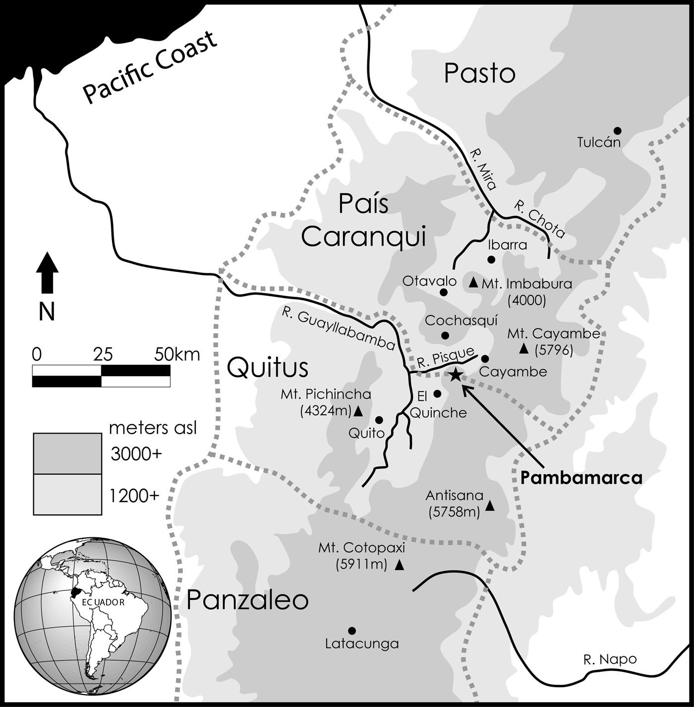
Figure 1. Regional map of northern Ecuador that includes locations mentioned in the text and the debated names of ethnic groups. Pambamarca is located along the proposed border between the peoples of Quito and the País Caranqui to the north (Map by C. Gifford).
The Inka are believed to have reached and conquered Quito in AD 1455–1460 under the reign of Topa Inka Yupanki. Huayna Capac led the Inka efforts to incorporate the peoples north of Quito during his reign from around AD 1490 until AD 1505/1525. Chroniclers allude to the importance of the region (Betanzos Reference Betanzos1987[1551–1557]:214–217; Cieza de León Reference Cieza de León and von Hagen1959[1553]:261; de la Vega Reference de la Vega1961:279; Espinosa Soriano Reference Espinosa Soriano1988; Montesinos Reference Montesinos1957[1644]:111; Murra Reference Murra and Steward1947). The new territory would have provided many economic gains to the empire: northern Ecuador had fertile farm land and resources, particularly in the upper reaches of the rainforest, and extensive preexisting trade routes with access to exotic goods (Alchon Reference Alchon1991:8; Salomon Reference Salomon1986).
According to chroniclers, most people on the northern frontier did not welcome the Inka: the País Caranqui groups banded together and ferociously resisted the Inka for a decade or longer (Betanzos Reference Betanzos1987[1551–1557]; Cabello Valboa Reference Cabello Valboa1951[1586]; Cieza de León Reference Cieza de León and von Hagen1959[1553]; Cobo Reference Cobo1979[1653]; de la Vega Reference de la Vega1961; Montesinos Reference Montesinos2010; Sarmiento de Gamboa Reference Sarmiento de Gamboa, Bauer and Smith2007 [1572]). We believe these groups were well positioned to offer stiff resistance because intraregional struggles were already part of the narrative (see Arkush Reference Arkush2011 on the Colla). These groups had been in “balanced opposition”: a power dynamic in which local feuds could be easily dropped in favor of confederations bound together to confront imperial invaders. The weakly integrated and decentralized País Caranqui may have been stronger precisely because of these heterarchical coalitions. Describing his concept of the tribal imagination, Fox (Reference Fox2011:78) contextualizes Arab resistance to western empires in terms of the Arab proverb, “I against my brother; my brother and I against my cousins; my cousins and I and my brothers against the world.” He argues that tribal states are, in a sense, the default form of social organization, providing the social glue necessary to make a sustained defense against larger complex imperial bureaucracies.
When the Inka arrived, Cieza de León noted, “Those of Otavalo, Cayambe, Cochasquí, Pifo, and other peoples north of Quito had made an alliance among themselves not to allow themselves to be dominated by the Inca” (Reference Cieza de León and von Hagen1959[1553]:48); Cabello Valboa corroborated this account (Reference Cabello Valboa1951[1586]:369). Guaman Poma de Ayala (Reference Guaman Poma de Ayala and Urioste1980:140) memorialized the resistance in a drawing depicting the gruesome visages of the indigenous Ecuadorian populations engaging in a pitched battle against the tenth Inka captain Challco-Chima (Figure 2). After initial setbacks, the Inka regrouped and sent mitimaes from southern Ecuador to construct fortresses along the frontier. Additional battles were fought over a period spanning at least a decade. In one battle Huayna Capac was almost killed at one of the Cayambe fortresses (Cobo Reference Cobo1979[1653]:157; see also Betanzos Reference Betanzos, Hamilton and Buchanan1996[1557]; Sarmiento de Gamboa Reference Sarmiento de Gamboa1960[1572], Reference Sarmiento de Gamboa, Bauer and Smith2007[1572]). Later, the Inka, using reinforcements from Cuzco and Tomebamba, tricked the indigenous soldiers into leaving their fortresses and deployed a surprise attack that ended the resistance. Twenty to thirty thousand País Caranqui soldiers then fled to Yaguarcocha (the Lake of Blood) near modern-day Ibarra where every able-bodied male was supposedly slaughtered (Cieza de León Reference Cieza de León and von Hagen1959[1553]; Cobo Reference Cobo1979[1653]; Sarmiento de Gamboa Reference Sarmiento de Gamboa, Bauer and Smith2007[1572]). Once victorious, the Inka continued northward into the Pasto territory of modern Colombia and ruled the area until the arrival of the Spanish.

Figure 2. El décimo capitán by Guaman Poma de Ayala (Reference Guaman Poma de Ayala and Urioste1980:140). The Cayanbi (Cayambe) are noted here as an enemy. The Inka soldier is swinging a slingshot, a common weapon from our excavations. Note the expression of fear on the faces of these Inka warriors.
The Pambamarca Complex
Located about 40 km east–northeast of Quito in the Cayambe Province, the Pambamarca complex consists of 18 installations spaced a kilometer or more apart on top of and around the ridges and peaks of the extinct Pambamarca stratovolcano (Figure 3; Table 1). Two basic environmental zones define the 150 km2 area of Pambamarca; the upland páramo above 3,000 m asl where 15 sites are found and the lower temperate zone below 3,000 m asl where 3 sites are found.

Figure 3. Topographic map of the Pambamarca complex. Pi26 in El Quinche lies just off the map to the southwest, and the highest fortress, Cangahua Pucara is farther up the ridge line on the continental divide to the southeast (Map by S. Connell and C. Gifford).
Table 1. Archaeological Sites of the Pambamarca Complex.

The Pambamarca Archaeology Project (Proyecto Arqueológico Pambamarca) began under the auspices of the Instituto Nacional de Patrimonio Cultural del Ecuador (INPC) with a goal of determining who built and used the sites, given that historic sources, chroniclers, colonial visitas, and even modern lore disagree on that subject. Chronicler accounts often referred to these installations as forts or pucaras, but attributed them to both Inka and indigenous builders, with no details given to differentiate the two (Cieza de León Reference Cieza de León and von Hagen1959[1553]:47; Cobo Reference Cobo1979[1653]:157; Espinosa Soriano Reference Espinosa Soriano1988; Ramón Valarezo Reference Ramón Valarezo1987; Salomon Reference Salomon1986; Sarmiento de Gamboa Reference Sarmiento de Gamboa, Bauer and Smith2007[1572]:141–144). For example, Cieza de León first noted, “Knowing of his (Huayna Capac's) presence in Quito… they (the indigenous) had built forts and stockades,” and then a page later wrote this: “The Inka and his army came as far as this region (north of Quito), and there he ordered stockades and fortresses, which they call pucaras” (Reference Cieza de León and von Hagen1959[1553]:47, 48). These accounts thus have proven to be useful but problematic tools, because many contain inherent colonial biases, Eurocentric descriptions, and chronological discrepancies (Julien Reference Julien and Malpass1993, Reference Julien2000; Morris Reference Morris, Collier, Rosaldo and Wirth1982; Rowe Reference Rowe1945, Reference Rowe and Steward1947; Stanish Reference Stanish2001). Part of the ambiguity noted in accounts about Pambamarca may also stem from a lack of understanding by the Spanish about what the term pucara actually encompassed, or bias may have existed regarding the features and functions that fortresses “should” have (Keeley et al. Reference Keeley, Fontana and Quick2007:56). Possibly the term “fortress” may be too limiting for the Pambamarca sites and many others within precontact South America (Arkush Reference Arkush2011).
Previous archaeological work in the northern Ecuadorian highlands began with site recording by Squier (Reference Squier1877), Uhle (Reference Uhle1926, Reference Uhle and Gonzalo Orellana1930, Reference Uhle1939, Reference Uhle1960[1925]), and Jijón y Caamaño (Reference Jijón y Caamaño1914, Reference Jijón y Caamaño1952). Pre-Inka Late Period sites are characterized by earthen hemispherical mounds (tolas) and massive truncated platform mounds, some with ramps hundreds of meters long. Although many mounds have been destroyed, evidence shows pre-Inka centers were located near Ibarra, Otavalo, Zuleta, Cochasquí, Cayambe, and El Quinche (Figure 1), with the last two sites being the closest to our study area (Cordero Ramos Reference Cordero Ramos1998; Jijón y Caamaño Reference Jijón y Caamaño1914). Survey and excavations were also completed in the Pambamarca complex (Fresco et al. Reference Fresco, Colima and Espíndola1990; Hyslop Reference Hyslop1990; Oberem et al. Reference Oberem, Wurster, Hartmann and Wentscher1969; Plaza Schuller Reference Plaza Schuller1976, Reference Plaza Schuller1977, Reference Plaza Schuller1978) and are discussed in detail later in the article.
Archaeological Survey
Initially funded by an NSF High Risk Grant (BCS-0331866), our work began with three survey phases: (1) ground-truthing existing site maps and remapping them if necessary, (2) locating previously unrecorded features, and (3) using geophysical techniques to look for early construction phases. We produced detailed site maps for each of the 18 sites (Figure 4; see Plaza Schuller Reference Plaza Schuller1977) and identified 3 site types (Table 1).

Figure 4. Survey maps of Type I, II, and III sites. (a) Pi17 Celda Pucara (Type I) and Pi16 (Type II) are connected by a sunken trench that runs through part of the fortress complex connecting the forts. (b) Pi24 Pucarito (Type III) is at 3,020 m asl in the temperate zone, with no standing structures and visible eroded architecture made of cangagua (Maps by C. Gifford and O. Wigmore).
Type I. Nine sites found in the páramo at an average elevation of 3,780 m asl are large installations all constructed of masonry stones that were mined from the immediate location and averaged 6.70 ha in area (excluding the partially mapped and largest, Cangahua Pucara; Table 1). These pucaras contain typical defensive features, such as multiple high concentric stone walls around a hilltop or ridge averaging 2–5 m in height, with deep fosses and adjacent parapets (noted in Keeley et al. Reference Keeley, Fontana and Quick2007). At least three Type I sites and one Type II site are connected by deep trenches measuring 1 m wide and 1–2 m deep that could be used to move soldiers quickly and safely between sites (Figure 4). Within the sites, entryways are baffled or tightly controlled or lead into open spaces that either contain numerous well-preserved stone structures, large boulders, or rock outcrops (interpreted as huacas) or nothing at all. Numerous rectangular house compounds, known as kanchas, contain two to four structures arranged around a patio. The typical structure size averages around 5 m2; many of these structures are protected from east-to-west winds by their leeward location. A combination of magnetometry, resistivity, and ground-penetrating radar (GPR) at two Type I sites did not uncover any buried architecture nor did excavations reveal any pre-Inka occupation phases, suggesting a single phase of construction and abandonment (Sullivan Reference Sullivan2007).
Most Type I enclosures have two significant Inka architectural features: an ushnu platform and a kallanka. Ushnus, strategically placed multitiered platforms, sometimes with a staircase, ramp, or shrine, were often found at the center of the site, in large open areas, or in main plazas. Although their exact function is debated (see Ramón Reference Ramón2017), they were thought to define sacred and political spaces (Hyslop Reference Hyslop1990; Meddens Reference Meddens1997; Meddens et al. Reference Meddens, McEwan and Pomacanchari2010; Meyers Reference Meyers, Burger, Morris and Mendieta2007; Moore Reference Moore1996; Staller Reference Staller and Staller2008). The second Inka feature is the kallanka, a long rectangular construction containing multiple entrances and sometimes gabled roofs (Hyslop Reference Hyslop1990). Again, ambiguity surrounds this term, which may possible refer more to the structure's architectural form than its function. Most times kallankas are characterized as meeting halls or officer barracks, and although there is no consensus around a standardized kallanka size, they are much larger than other structures and are often located near features such as the ushnu and away from kanchas (Hyslop Reference Hyslop1990).
Type II. Six high-elevation enclosures in the páramo (average elevation of 3,837 m asl) are smaller than the Type I installations, averaging 1.92 ha in area; they are defined by one or two low stone walls (less than 2 m high) surrounding central spaces containing few structures and few artifacts. Rather than being military in function, it appears that most Type II sites served ceremonial and/or economic functions within the Pambamarca complex (Anderson Reference Anderson2014).
Type III. Three large fortresses are found in the lower temperate zone at an average elevation of 2,943 m asl. These installations have an average size of 11.03 ha, are defined by high terrace walls and no visible standing architecture, and have suffered a high degree of damage from modern farming. Unlike Type I and II sites, a high density of living debris, including pottery, mammal bones, lithic and groundstone artifacts, was found on the surface. Excavations within the domestic terraces exposed local pre-Inka ceramic artifacts, sling stone caches, and the highest concentration of Inka-style pottery found at Pambamarca.
Architecturally, multiple construction phases are evident, suggesting continued use through time. Type III fortresses are composed of large shaped blocks mined from the local hard-packed, consolidated volcanic ash subsoil known as cangagua. Research from other sites in the País Caranqui (Athens Reference Athens2003; Bray Reference Bray1991; Cordero Ramos Reference Cordero Ramos1998; Currie Reference Currie2001) characterizes this construction method as a local indigenous architectural style, suggesting the possibility that these enclosures were built by the Cayambes before Inka contact or during the imperial process. A survey completed between the Type III sites showed the existence of previous and contemporaneous sites, and future research is needed to determine how they fit into the imperial narrative of Pambamarca.
Archaeological Excavations at Type I Sites: Quitoloma and Campana Pucara
Although all site types are vitally important to the holistic narrative of imperial formation at Pambamarca, our analysis in this article focuses on excavations at two Type I sites, Quitoloma (Pi10) and Campana Pucara (Pi23). Archaeology sites in the Pichincha province of Ecuador are given the designation Pi and a number, although we use site names recorded in historic records or noted by local communities where possible (Table 1).
Quitoloma (Pi10)
Characterized by high concentric walls with deep exterior ditches draped over a large hill (Figures 5 and 6), Quitoloma marks the southern extent of the Pambamarca complex and offers views south toward Quito. Initially investigated by Oberem and colleagues (Reference Oberem, Wurster, Hartmann and Wentscher1969), Quitoloma measures 450 m long by 280 m wide: the 10.9 ha area is divided by interior walls into seven spaces that contain structures, exposed bedrock outcrops, solitary boulders, a natural water source, and open sections devoid of settlement (Figure 5). Based on survey and five test excavations, Oberem determined that Quitoloma was an Inka fortress built to conquer the Cayambe. Excavations of one circular structure (S1), three rectangular structures (S2–4), and a unit in the open area to the south (S5) recovered surprisingly strong signatures of Inka life, including aribalo fragments, a flute, a spear point, spindle whorls, obsidian, and bola stones (Oberem et al. Reference Oberem, Wurster, Hartmann and Wentscher1969). Our research expanded on Oberem's work to investigate additional residential structures, the ushnu, kallanka, entranceways, and more open spaces. We also conducted a systematic survey of plowed fields outside the main walls, finding no evidence of structures or occupation other than the Inka roads discussed later (Sistrunk Reference Sistrunk2010).

Figure 5. Quitoloma survey map with points from the text labeled (1) entranceway location, (2) ushnu, (3) kallanka, (4) kanchas or patio groups, and (5) armory or munitions storehouse (Map by C. Gifford).

Figure 6. Quitoloma research photographs and plan drawings: (a) looking north from the middle of the site with the kallanka in the foreground to the left, the ushnu in the middle right, and along the distant ridge to Pambamarca pucara (Pi14); (b) plan drawing of a typical room block, marked #4 on Figure 5; (c) entranceway reconsolidation completed by Rudy Larios; (d) example of sling stone war bag from the Cochasquí site museum; (e) and (f) sling stone deposit or ammunition dump in Structure 14 interpreted as an armory or weapons storehouse (Photographs by D. Morin, S. Connell, and C. Gifford; drawings by Lucas Johnson, Ana Kim, and Brandon Lewis).
On the north end, Quitoloma is defined by three enclosed interior areas with standing architecture, contained by three successive concentric walls (Figures 5 and 6a). The incomplete defensive ditches and walls suggest abandonment of the site or termination of its need. To the south lies a partially enclosed section with kanchas abutting an open space containing the kallanka, after which a buffer zone exists before the main residential portion farther south. This section contains 104 mapped structures in patio groups, bisected by main avenues, alleys, or the water source; many have interconnected walls, suggesting densely packed living quarters (Figure 5). Closer to the kallanka, fewer residential structures are found, and their size (6 x 3 m in the interior; Figure 6b) differs markedly from that of room blocks located in the south (3 x 2 m in the interior, label #5 in Figure 5). The differences in structure size may indicate that high-status Inka lived in the north end, separated from the other soldiers.
To the south and east of the main living area there are walled-off empty spaces, some of which contain several large boulders thought to be huacas. Excavations by Oberem and colleagues (Reference Oberem, Wurster, Hartmann and Wentscher1969) at the southernmost point recovered a cache of Inka-style ceramic artifacts associated with a prominent rock formation. Testing by our team in these empty areas produced no artifacts, but it is possible that the area was used for herding, military practice, or activities associated with huacas.
A total of seven entrances are found in the outer walls. A single doorway on the northeast side offers the easiest point of access, but leads to a deep, walled-off dead space, perhaps constructed to lure combatants into a passageway designed for ambush. To the north a restricted entrance with a guard post leads to the inner areas. Four simple entrances are found on the southeast side, likely designed to allow warriors to stream out and overwhelm an opponent. Access to the main interior occurs via an entrance to the west (label #1 on Figure 5). The locale was excavated in some detail by Antonio Fresco and colleagues (Reference Fresco, Colima and Espíndola1990) and then reexposed in 2003 by Rudy Larios to reconsolidate and preserve the stairway (Figure 6c). This entrance to the west was heavily guarded: masonry walls extend north and south from the lower steps reaching 3 m in height. At the top of the stairwell a 1 m thick freestanding wall abuts the northeast corner, forcing entrants to turn left for site access. Inside the entranceway an embrasure was built to hide a sentry, and nearby a dense collection of more than 50 sling stones was recovered.
Quitoloma's Inka masonry style consists of roughly worked stone blocks carefully fit together with mortar and chinking stones, all of which can be mined at the site. Excavations showed no stratigraphic evidence of earlier construction or occupation, indicating that Quitoloma was constructed in a single phase and not over an indigenous settlement. Exposed charred material from construction fill at the interface with sterile soil (near #4 on Figure 5) was radiocarbon dated to 330 +/- 40 BP (Beta-240835; δ13C = −23.71%) or 1450–1650 cal AD (calibrated at 2σ with the program IntCal04), within the expected range for Inka construction and occupation. The calibration curve for northern Ecuador extends date ranges, yielding the misleading continuation of the date into Spanish colonial times.
Quitoloma's ushnu is located at the north end in a small enclosed plaza (label #2 in Figure 5), with two terrace levels and a central staircase leading down its south side. The quadrilateral mound, measuring 12 m x 16 m and 2.7 m high, was heavily looted, and salvage work within found no previous occupation layers. Access to the ushnu tier was possible via two 1 m wide doorways on the east and west sides. Small amounts of Inka ceramic vessels were found along the basal steps of the ushnu and alongside low walls of a structure in the plaza to the south.
In 2005 excavations also occurred at the kallanka, a large rectangular structure measuring 14 m x 7 m located in the central plaza area (label #3 in Figure 5). Initially identified as the Inka casa comunal by Oberem and colleagues (Reference Oberem, Wurster, Hartmann and Wentscher1969), the building had two doorways on the west side. GPR survey and excavations showed that a smaller adjoining room on the north side was added later (Sullivan Reference Sullivan2007). Two trenches across the kallanka's center produced a handful of Inka pottery forms such as arribalos (Form 1), one footed ollas (Form 10), and shallow dishes (Form 13; Bray Reference Bray1991: Figure 7.5; Meyers Reference Meyers and Oberem1981); a third trench exposed low masonry walls.
Our work within the residential area focused on expanding on what Oberem had recovered in an effort to better define the occupants of the site, use of the site, and length of occupation. We chose to excavate 12 rectangular structures and patio areas from across the site. All contained evidence indicative of daily activities, such as food preparation and weaving, with finds including different cooking and serving vessels, groundstone fragments, spindle whorls, faunal remains, and other artifacts associated with the mundane. These utilitarian findings do not occur in dense concentrations, indicating a shorter-term occupation, but they do provide evidence that families accompanied soldiers on their deployments. Several kanchas appear to have expanded as the number of occupants rose. For example, excavations at the north and west structures of a patio group nearest to the kallanka (label #3 in Figure 5) uncovered secondary filler walls abutting the original structures, creating a kitchen space with dense amounts of burned animal bone and cooking vessel fragments.
By far the most common artifact recovered within every residential structure excavated at Pambamarca was the sling stone. At many Andean fortified sites, sling stones tend to dominate because they are usually readily available and transportable (Topic Reference Topic, Tkaczuk and Vivian1989). In Quitoloma structures, they were often found in stacks of seven or more placed directly inside the doorway and in association with small obsidian blade fragments and a single nondiagnostic sherd (see the later discussion of the example from Campana Pucara). The consistency of this pattern suggests that warriors may have traveled with pouches (like a Scottish sporran) that contained these items. The broken sherd could provide extra support and strength to the bottom of the bag, and the obsidian blade fragments could have been inserted into clubs or mace heads. This interpretation of Inka “war bags” is supported by the discovery of a bag by Max Uhle at Jaquí in the Yauca Valley, Peru, now located in the Hearst Museum (artifact number 4-8306). Another example is on display at the nearby Cochasquí site museum (Figure 6d).
The most obvious example of militarism at Quitoloma was the discovery of an armory for ammunition storage. Excavations at Structure 14, in a patio group on the south side, exposed a top layer of pottery, a spindle whorl, a boleador, and a concentration of 171 sling stones in the southeast corner that was too dense to remove and likely covered still more ammunition beneath it (label #5 in Figure 5 and see Figure 6e and 6f). Charred material recovered from the living surface yielded a carbon date of 380 +/- 40 BP (Beta-240836; δ13C = −23.21%) or 1440–1640 cal AD (calibrated at 2σ with the program IntCal04). It is puzzling that so much ammunition was left behind at the site. The occupants of Quitoloma may never have had the opportunity to go to battle, or the need to carry ammunition lessened as the Inka moved northward. It also may have been common practice to leave everything behind when the soldiers went home, or perhaps Quitoloma was left stocked in case of future needs, befitting a defense in-depth strategy (D'Altroy Reference D'Altroy1992). Some chroniclers suggest the forts in Cayambe were still occupied during the reign of Atahualpa before the arrival of the Spanish (Betanzos Reference Betanzos, Hamilton and Buchanan1996[1557]:200). Whatever the reasons, Quitoloma continues to exist in an abandoned state of readiness.
Campana Pucara (Pi23)
Investigations at Pambamarca also focused on Campana Pucara primarily because of its excellent preservation and critical position as the northernmost Type I site (Figures 3 and 7). Campana Pucara was a strategically important locale for rebuffing enemy attacks and for maintaining vigilant oversight of troop movements because it overlooked the Cayambe basin and would have been the initial line of defense (Figure 8a). When compared to Quitoloma, the material record of the site is better preserved and contains similar, but more accessible, architectural patterning. The site is defined by five concentric walls divided into sections containing 23 structures on the leeward side below the ridge top (Figure 7). There are three aligned entrances on the north side and a single entrance to the south that link Campana Pucara by a trench to Pi17, Pi16, and Pi14 (Figures 3 and 4). Several of the outer walls are associated with defensive features: deep ditches and parapets. The absence of pre-Inka occupation phases, coupled with the presence of partially worked stone blocks, an ushnu with a ramp, a kallanka, several kanchas, and high counts of weaponry and Inka style pottery, suggests that the site is Inka (Figure 7).
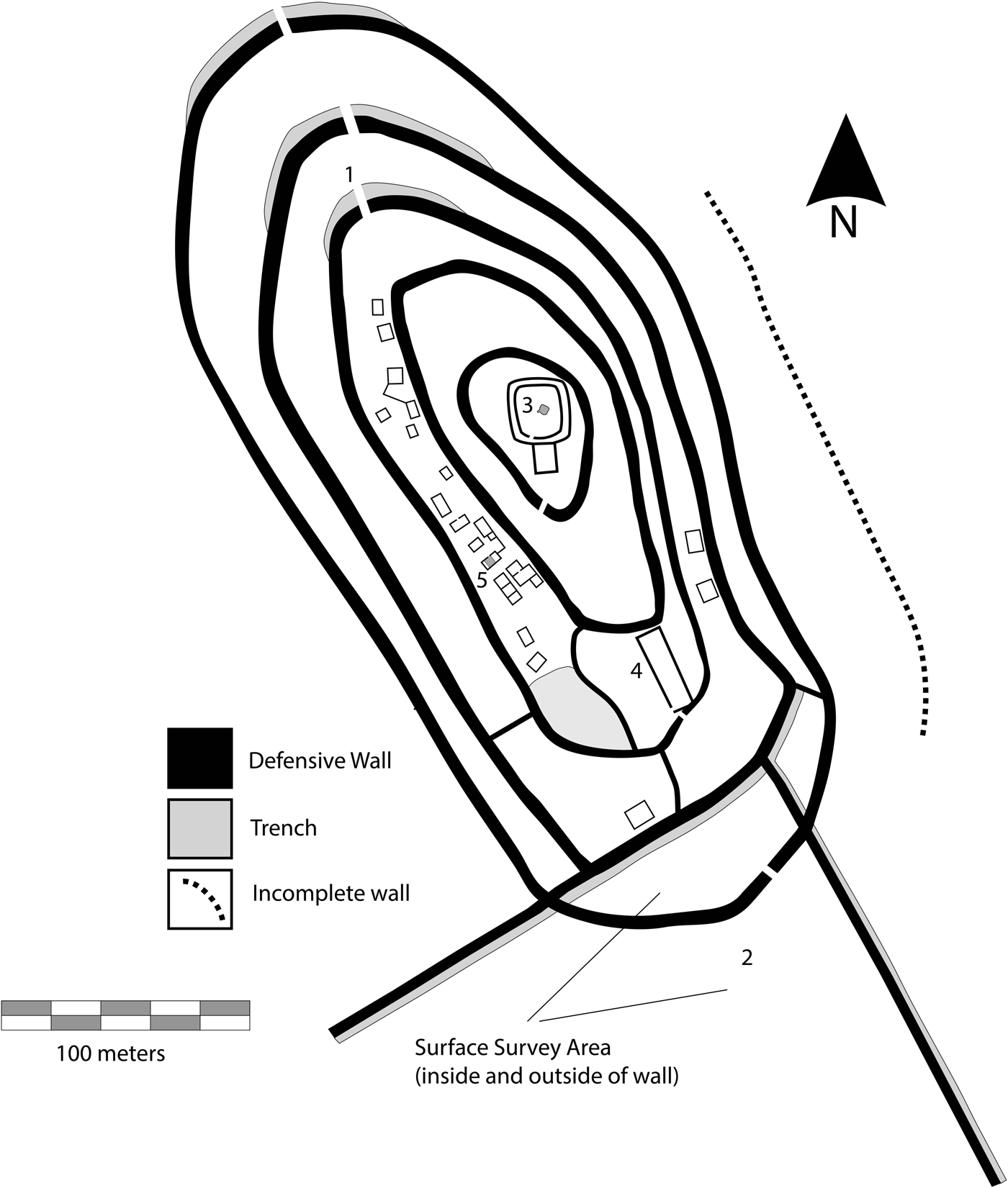
Figure 7. Campana Pucara survey map with points from the text labeled (1) entranceway and exterior wall excavations; (2) survey area for sling stones inside and outside of walls; (3) ushnu; (4) kallanka and area of GPR survey; and (5) room block excavations (Map by C. Gifford).
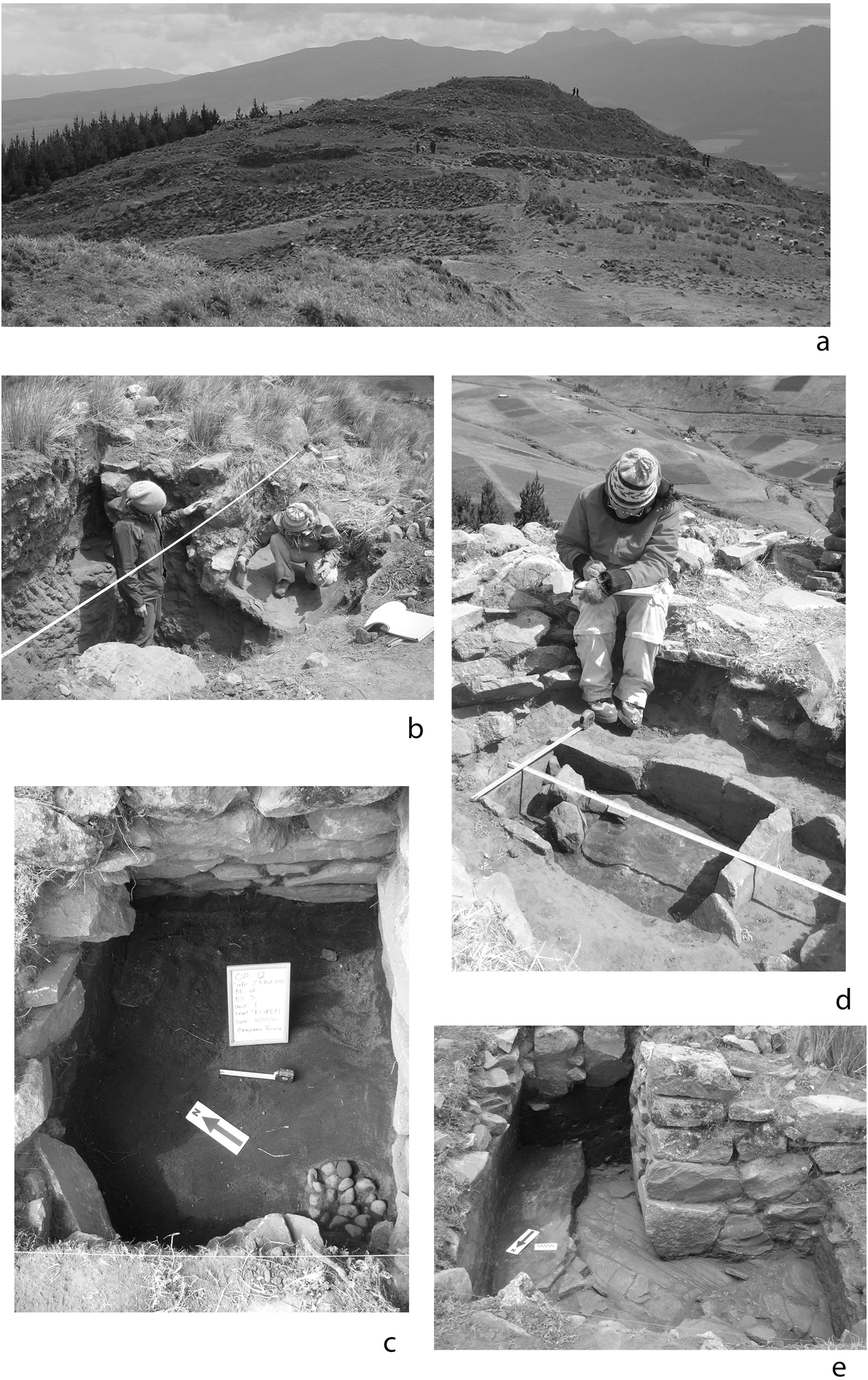
Figure 8. Campana Pucara research photographs: (a) Looking north into the main entranceway from the south, note the plowed areas that were surveyed, which have sling stones in the foreground field and none in the background field. People are standing at the kallanka inside the main gate; (b) students are cleaning the looter's trench, exposing wall construction and a tamped rampart sloping off the wall; (c) sling stone cache is found inside a residential structure; (d) documentation of the stone-lined box in the area marked #5 in Figure 7; (e) layer of charred material below the architecture marked by a north arrow. The standing Inka construction on the right cuts into the deposit, and a later wall addition is above the burned deposit at the back of the unit. Photographs by A. Anderson, S. Connell, and C. Gifford.
Our initial excavations were made along a northern inner defensive wall (label #1 in Figure 7) and a nearby looter's trench (Figure 8b) and were directed to identifying wall construction techniques and the existence and/or depth of a floor. They revealed that the wall was faced with large stones on each side, and a fill (uniform in color, content, and texture) was added, indicating it was erected in a single construction episode. An orange clay cap rested on top of the fill inside the wall, which may have (1) provided a hard surface between the uppermost courses of stones used to house sling stones or bolas and (2) served as a type of mortar that helped hold the wall together. Two compacted floors were recovered that abutted to the lowest course of stones on the inside face of the defensive wall. The older flat floor was connected to the lowest course of stones, and ceramic vessels from the floor surface showed evidence of burning. A sloped or ramped ephemeral second floor was added later, which likely served as a banquette to elevate interior combatants above the wall to better launch sling stones. It is possible that other walls on the north side have similar defensive features, especially given that many are lined with northern ditches that make access difficult.
Findings from additional excavations support the militarized nature of the site. Seven excavation units placed in residential structures on the western side produced caches of sling stones (label #5 in Figure 7). These were usually stockpiled near entrances, bastions, parapets, outer walls, or within structures, and the size, quantity, and placement of the stones are identical to those uncovered at Quitoloma (Figure 8c). Although we did not find a weapons storehouse, it is possible it remains hidden in an unexcavated structure. Not only were sling stones recovered in situ but they were also found outside the site during a salvage survey. Although the highland sites tend to have incurred less farming damage than the lowland sites, part of the southern perimeter wall was plowed between field seasons, which provided an opportunity to conduct a surface survey both on the interior and exterior of the wall (Figure 7, label #2, and Figure 8a). The difference in the collections from each area is striking. The interior collection was dominated by Inka ceramic forms and lithic artifacts, whereas the exterior collection had far more sling stones than other artifacts. Furthermore, these sling stones were found clustered toward the southern end of the plowed field, leaving a noticeable gap free of sling stones closer to the circuit wall, indicating that these stones were slung from inside toward groups on the outside (and not, for instance, slung toward the walls from outsiders). These findings are therefore some of the project's clearest evidence for possible acts of violence within Pambamarca.
Similar to Quitoloma, the cleaning of a deep looter's trench within the ushnu showed that it was built in a single phase (label #3 in Figure 7). Attempts to locate earlier construction phases were also made using a geophysical survey within the main plaza adjacent to and overlapping the kallanka (label #4 in Figure 7): it identified no subsurface architectural features. A combination of GPR, magnetometry, and resistivity survey did demarcate the kallanka limits, defined by its large rectangular shape and the presence of three doorways in the west wall. Four excavation units in the southern end revealed that the wall's fill contained embedded carbon deposits radiocarbon dated to the Inka Period. The conventional radiocarbon age for collected charred material is 340 +/- 40 BP (Beta-241879; δ13C = −23.9%) or 1450–1650 cal AD (calibrated at 2σ with the program IntCal04). Evidence from the area west of the kallanka suggests that an outside plaza abutted the second-lowest course of the kallanka wall. In contrast to the Quitoloma pottery, an excellent collection of finely decorated pieces and discarded Inka ceramic artifacts, including Forms 1, 10, and 13, were found in a small alleyway between the kallanka and the outer defensive wall to the south. Although ceramic artifacts dominate the collection, we also found lithic artifacts and sling stones; however, the quantity of munitions recovered here was far lower than in residential parts of the site.
We also conducted research at five stone structures and one patio area within the western residential sector of the site (label #5 in Figure 7). The structures, measuring between 2.5 m x 4 m to 5 m x 5 m, contained Inka and local País Caranqui ceramic wares, ammunition, spindle whorls, and lithic artifacts, suggesting that a variety of activities occurred within these buildings. Several of the structures had two living floors. Older floors extended beneath standing walls and were associated with burned artifacts and ash deposits, a sample of which yielded a date of 340 +/- 40 BP (Beta-240838; δ13C = −22.0%) or 1450–1650 cal AD (calibrated at 2σ with the program IntCal04). One structure contained a sunken stone-lined box filled with carbonaceous material, which was perhaps used for heating the room or cooking food (Figure 8d). Evidence of charred material from its last use dates to 400 +/- 40 BP (Beta-241878; δ13C = −22.9%) or 1430–1530 cal AD, 1560–1630 cal AD (calibrated at 2σ with the program IntCal04), and 1440–1490 cal AD (1σ calibration with a single intercept). These dates, like those from Quitoloma, coincide with activities primarily taking place during the transition from the Late Period to the Inka Period.
One anomalous feature was a sample of charred material either from a collapsed thatched roof or an estera (woven floor mat), which was found directly on the bedrock and below the architecture; it was associated with an extensive ash layer containing calcined bone, carbon, Late Period and Inka Period ceramic artifacts, burned soil, and extensive fibrous residue (Figure 8e). Our radiocarbon date was clearly pre-Inka Late Period, 550 +/- 40 BP (Beta-241839; δ13C = −19.0%) or 1310–1360 cal AD or 1380–1440 cal AD (calibrated at 2σ with the program IntCal04). This isolated evidence for Late Period activity, although tantalizing, does not tie to any architectural construction, but it does suggest that some places on Pambamarca were used before the Inka arrived.
Based on the evidence recovered and presented here, it is possible to make a few summary statements about the nature of the construction and occupation of Campana Pucara. First, evidence shows this site was constructed quickly but thoroughly. For example, the large concentric defensive walls were constructed with field stones that were cut or worked to form well-fitted masonry faces and were erected in one building episode. Second, evidence has emerged suggesting later, less monumental building (or rebuilding) episodes. As noted, an additional floor was constructed along the interior of a northern defensive wall, and some residential areas had walls added later that were built over soil deposits containing artifacts. There is no evidence that the site was abandoned between these episodes nor that it was immediately occupied by a new group of people: the architecture and material culture remained uniform. The second moment of building may have happened rapidly after a brief disruption, signified by the presence of ash in most units. For the moment, it appears that this disruption was caused by a Cayambe attack, after which the site was repaired. Third, we can solidly state that material evidence shows the population living in Campana Pucara was well equipped for battle. Sling stones were recovered both inside residential structures in small caches, similar to those found at Quitoloma, and scattered in the field outside the outermost defensive wall. When this evidence is considered in conjunction with other overt military features of the settlement, we can confidently state this site was on the leading edge of the Inka military attack against the País Caranqui.
Discussion
The Inka imperial process was multivariate in practice, and the northern frontier of Tawantinsuyu was no exception. Earlier discussions of soft versus hard power, although useful, often simplify complex narratives of imperial domination and resistance (Alconini Reference Alconini2008; D'Altroy Reference D'Altroy1992; D'Altroy and Schreiber Reference D'Altroy, Schreiber and Silverman2004; Hassig Reference Hassig1988; Khatchadourian Reference Khatchadourian2016; Shimada Reference Shimada2015), and recent work for the Inka has moved past these dichotomies (Alconini Reference Alconini2016). Our research at Pambamarca, although far from complete, is beginning to flesh out these variations in the imperial narrative. With its three site types, work at Pambamarca provides an opportunity to examine the range of tendencies that groups undergo during imperial moments. Although not presented in detail here and awaiting further research, the Type II and III sites at Pambamarca suggest an Inka strategy of partial sovereignty with hegemonic control dictated by indirect rule, in which power was delegated to the local elites and reinforced through imperial material culture. These low-control, low-extraction resource procurement strategies in the provinces relied on reciprocal trade routes between Cuzco and places where local elites were established (Alconini Reference Alconini2008, Reference Alconini2016; D'Altroy Reference D'Altroy1992; D'Altroy and Schreiber Reference D'Altroy, Schreiber and Silverman2004; Hassig Reference Hassig1988; Malpass and Alconini Reference Malpass and Alconini2010). Under these conditions preexisting interaction spheres were consolidated, commerce was incorporated or altered, and little investment was put into military facilities or imperial infrastructure outside key locales, with peripheral centers being maintained by local elites and societies (D'Altroy Reference D'Altroy1992; Luttwak Reference Luttwak1976).
Nevertheless, as Alconini (Reference Alconini2016) and others have noted, Inka control strategies were frequently in flux based on their desired wants or needs from an area, especially along the frontiers. We argue that in the face of staunch resistance the Inka quickly implemented high-control, high-extraction resource strategies and constructed military installations exhibiting a form of direct rule. As elsewhere, monumental state architecture and imperial features, such as administrative centers, storage facilities, or agricultural terraces, were constructed, and the Inka co-opted local trade routes and resources, thereby affecting interregional exchange systems (Alconini Reference Alconini2008; Arkush Reference Arkush2011; Bram Reference Bram1941; Bray Reference Bray1991; Bray and Echeverría Reference Bray and Echeverría2014; D'Altroy Reference D'Altroy1992; DeMarrais et al. Reference DeMarrais, Castillo and Earle1996; Fresco Reference Fresco2004; Hyslop Reference Hyslop1990; Malpass and Alconini Reference Malpass and Alconini2010; Salomon Reference Salomon1986; Sistrunk Reference Sistrunk2010). For example, research in obsidian procurement at Pambamarca points to the use of specific resources by the Inka and their discontinued use by the Cayambe (Ogburn et al. Reference Ogburn, Connell and Gifford2009). This control was aided by the construction of the Inka roads found in Pambamarca. A stone-lined roadway climbs from El Quinche west of our study area and forks at the base of Quitoloma, with one path heading north toward Mt. Cayambe and another heading east toward Cangahua Pucara, a newly discovered pucara (Figure 3; Table 1). Located east of Quitoloma, the site is the highest in the region at 4,200 m asl, and it offers the broadest viewshed found at Pambamarca. Although Cangahua Pucara has not been tested, it is possible this locale was used by the Inka for command and control of movement through the area. This road heading east likely connects with a second road discovered near the village of Oyacachi (about 18 km away) that connects to the Quijos region, which sits at the upper reaches of the Amazon rainforest (Sistrunk Reference Sistrunk2010). The network of roads supports the premise the Inka were interested in controlling trade routes, which is strengthened by archaeological discoveries of Inka storehouses at Molino Loma adjacent to the Hacienda Guachalá north of Pi24 (Figure 3; see Fries Reference Fries2010).
Although control of economic resources and movement was important, military strength was a key component of this imperial process, with efforts put toward physically controlling the region through fortress construction. More than 100 pucaras have been documented in northern Ecuador, with Pambamarca representing the highest concentration of fortifications (Alconini Reference Alconini2004; Bray Reference Bray and Shimada2015; Hyslop Reference Hyslop1990; Lippi Reference Lippi1998; Plaza Schuller Reference Plaza Schuller1976, Reference Plaza Schuller1977). Research presented here describes our efforts to determine the nature of the Type I enclosures built in the high páramo, specifically to determine if there were features of direct control. We describe here two Type I sites, Pi10 Quitoloma and Pi23 Campana Pucara, and the evidence recovered shows both contained the following elements:
• architectural patterning indicative of an immediate defensive need
• room for, and evidence of, permanent garrisons used to secure a border and defend it
• weapons storage and individual munition deposits
• examples of attack, such as large-scale burning and subsequent rebuilding, or artifacts associated with an impending engagement
The upland sites were very well defended because of their location, multiple concentric walls, baffled or protected entryways, parapets, and guardhouses. Excavations revealed they were constructed in a single phase, with radiocarbon dates placing them solidly during the Inka-País Caranqui conflict, and Inka structural elements such as the ushnu and kallanka were discovered at each. Furthermore, weaponry is ubiquitous: caches of sling stones were found in most residential structures excavated, and an ammunition storehouse was discovered at Quitoloma, attesting to the military use of this site. The presence of utilitarian wares at both sites also indicates household activities and showed that people, even families, were permanently living within these walls for a period of time.
We suggest that the Inka thought of these enclosures as self-contained communities designed for the business of war. They are built in out-of-the-way locations with little opportunity for the occupants to exploit the surrounding environments, especially at Pambamarca where the Inka settled at higher elevations than the local sites. Of note, several survey transects between the Type I and II sites and the lower-elevation Type III sites did not produce any evidence of occupation, suggestive of an empty “no man's land” or buffer zone between the two zones (Figure 3). From up high the Inka could be masters of all below and import supplies from well-controlled areas to the south, while also establishing new routes of transport, such as the road to Oyacachi. In addition, they could run soldiers and supplies between fortresses using several trenches or pathways found connecting some of the sites (Figure 4). By the sheer number of Type I sites constructed at the Pambamarca complex, we can infer that there was a long-term standoff in which the Inka invested a great deal of resources to stabilize their military gains and continue to press northward to conquer the region.
Of special interest was evidence indicating an attack or struggle at Campana Pucara: sling stone artifacts recovered from outside the exterior walls indicated they had been thrown out of the fort. Additionally, at both Campana Pucara and Quitoloma there is strong continuity between artifacts and construction materials and methods, indicative of no change in the occupants, even though it is clear that they remodeled their homes and defenses. It does appear the sites were abandoned in a state of readiness, given the types, quantity, and quality of artifacts recovered. Although we cannot be certain when, why, or how the sites were abandoned, the lack of Spanish-era pottery does suggest they were not used when the Europeans arrived and thus were likely already abandoned by AD 1532.
We believe our data can help archaeologists understand the nature of empire. The evidence for a military encounter and the creation of a densely packed defensive installation supports our assertion that some of the Pambamarca sites were built in the face of staunch resistance, as told by the chroniclers. It is apparent the Inka invested a great deal of resources to extend their military gains and continue their expansion northward during this prolonged struggle. Subsequent research will flesh out other imperial tendencies that are sure to have been part of the complex imperial narrative of the northern frontier. We feel certain that behind this imperial moment we will uncover a local indigenous landscape of intraregional competition and warfare, one that explains additional dynamics of the imperial process.
Acknowledgments
First and foremost, the authors would like to thank the hundreds of students who contributed to the project, and we also owe a debt of gratitude to a long and diverse list of people. To begin with, we must acknowledge the major force behind the genesis of this research program, Don Carlos Pérez. In Quito, many thanks to the wonderful team of professionals at the Instituto Nacional del Patrimonio Cultural del Ecuador (permits granted in 2002–2006 have no numbers; 059-2007, 054-2009, 070-2011, 089-2012, and 059-2014 extended to 2015, 2016, and 073-2017) and at the Departamento de Arqueología represented by Fernando Mejía, Mónica Bolaños, Francisco Sánchez, Maria Moreira, and Rosillo Murillo. In Cangahua we are grateful to Padre Roberto Neppas, Elena Tandayamo, Elena Gualavasí, Maria Gualavasí, David and Mario Quimbiulco, Anibal and Rita Charro, and Franklin Imbaquingo. Also, we extend a very warm thank you to the Hacienda Guachalá and Diego Bonifaz, Gabriela Bonifaz, and Cristóbal Cobo. Thanks also to the members of the communities of Pambamarca, especially those in Chumillos Central and Melchor Farinango. Many scholars directly contributed and are always welcome to visit; they include Stephen Athens, Kathryn Maurer, Tamara Bray, Ernesto Salazar, David Brown, Florencio Delgado, Rudy Larios, Dennis Ogburn, Karen Stothert, Mariuxi Cordero, Manuel Coloma, Rudi Colloredo-Mansfield, Pepe Echeverría, Patty Mothes, Peter Hall, Ronald Lippi, Marc Becker, Larry Conyers, Brandon Lewis, and Alejandra Gudiño. We also owe a large debt of gratitude to the Ecuadorian students who have contributed to the project, including Julio Mena, Oscar Cajas, y Carlos Montalvo. We are grateful for the contributions of our home institutions—Foothill College, UCLA, and Columbia University—and their representatives. Our research has been supported partly by the National Science Foundation (BCS-0331866), the Fulbright Ecuador program, and the US Ambassadors Grant-in-Aid program, but primarily by our student field school program. Finally, to our staff and graduate students without whom we would have never been able to succeed in the work, thank you so very much for all your help. We are especially grateful for the assistance of these individuals: Mo Carpenter, Zev Cossin, Mary Sullivan, Vanessa Muros, Allison Loewen, Allison Gray, Angus Lyall, Morgan Hoke, Adriana and Andrea González, Siobhan Boyd, Ana Kim, Ollie Wigmore, Eric Fries, Eric Dyrdahl, Scotti Norman, Hannah Sistrunk, David Morín, Will Pratt, Ryan Hechler, Hannah Dibner, Brian Kranzler, Colin Jaramillo, Douglas Smit, Matt Golsch, Lucas Johnson, Valda Black, Sandy Schreyer, Ted Neff, Linda Neff, Kaitlin Yanchar, Angela Matusik, Matt Schauer, and Curtis Campaigne. Without them the work would never have come close to being completed. Thanks for teaching, helping, and listening.
Data Availability Statement
A complete digital copy of the data presented in this article is available on request from the author: connellsamuel@foothill.edu.


