


INTRODUCTION
Located on the margin of the East Asian summer monsoon (EASM) domain, the arid and semiarid zones in north China and Mongolia are particularly sensitive to climate change. Prolonged droughts in these areas caused by the weakened EASM could result in crop failure, soil degradation, and even desertification, posing detrimental impacts on human livelihood and ecosystem functionality (Lu et al., Reference Lu, Yi, Xu, Zhou, Zeng, Zhu and Feng2013; Yin et al., Reference Yin, Fang and Su2016). Specifically, the northern and western parts of East Asia represent an important dust source, where dust can be lifted and transported for thousands of kilometers by the westerlies to Korea, Japan, north Pacific Ocean, and even as far as North America (Uno et al., Reference Uno, Eguchi, Yumimoto, Takemura, Shimizu, Uematsu, Liu, Wang, Hara and Sugimoto2009). Dust aerosols are considered to play an important role in the climate system, influencing the Earth’s radiative balance, marine biogeochemical cycle, and atmospheric chemical composition (Uno et al., Reference Uno, Eguchi, Yumimoto, Takemura, Shimizu, Uematsu, Liu, Wang, Hara and Sugimoto2009; Maher et al., Reference Maher, Prospero, Mackie, Gaiero, Hesse and Balkanski2010; Middleton and Sternberg, Reference Middleton and Sternberg2013). Many kinds of archives such as ice cores, loess-paleosol sequences, and marine sediment cores show that the average dust deposition rate was higher during glacials than that during interglacials (Rea and Hovan, Reference Rea and Hovan1995; Steffensen, Reference Steffensen1997; Nagashima et al., Reference Nagashima, Tada, Matsui, Irino, Tani and Toyoda2007). However, the existing dust records appear to be latitudinally asynchronous, probably modulated by the meridional shift of the westerlies (Nagashima et al., Reference Nagashima, Tada, Matsui, Irino, Tani and Toyoda2007; Kang et al., Reference Kang, Roberts, Wang, An and Wang2015). Therefore, the relative contributions of source area aridity over the atmospheric circulations to the variations in the atmospheric dust loading inferred from geologic archives remain a topic of debate.
Lacustrine sediment grain-size parameters have been widely used to infer past environmental and climatic changes in various geological settings, as they are closely related to changes in provenance, transporting energy, and sedimentary process (Sun et al., Reference Sun, Bloemendal, Rea, Vandenberghe, Jiang, An and Su2002; Xiao et al., Reference Xiao, Si, Zhai, Itoh and Lomtatidze2008; Dietze et al., Reference Dietze, Hartmann, Diekmann, Ijmker, Lehmkuhl, Opitz, Stauch, Wünnemann and Borchers2012). For example, a few studies suggest that lacustrine deposits are often derived from multiple sediment sources, which are transported by different processes (e.g., fluvial, alluvial, aeolian, or glacial) and are well-mixed after being deposited in the lake basin (Liu et al., Reference Liu, Dong, Yang, Herzschuh, Zhang, Stuut and Wang2009; Dietze et al., Reference Dietze, Hartmann, Diekmann, Ijmker, Lehmkuhl, Opitz, Stauch, Wünnemann and Borchers2012; Xiao et al., Reference Xiao, Chang, Fan, Zhou, Zhai, Wen and Qin2012; Xiao et al., Reference Xiao, Fan, Zhou, Zhai, Wen and Qin2013). Therefore, traditional approaches (e.g., moment-based descriptive statistics) are limited in scope and unable to unravel the complex transport and deposition processes from the spectrum of individual lacustrine sediment samples. Recently, many numerical methods, including curve fitting and eigenspace analysis, have been proposed to partition the grain-size components of sediments and retrieve proxy information sensitive to transport and deposition dynamics. Curve fitting using a prescribed kernel distribution function (e.g., lognormal or Weibull distribution function) requires some prior assumption of the grain-size distribution of the subpopulation, resulting in the interpretation of the fitting parameters might be not be geologically meaningful (Yu et al., Reference Yu, Colman and Li2016). In contrast, eigenspace analysis makes full use of all samples based on principles of numerical inversion to reduce information redundancy and takes into account the unit-sum constraints. In this case, the shapes of the end members do not have to be specified (Dietze et al., Reference Dietze, Hartmann, Diekmann, Ijmker, Lehmkuhl, Opitz, Stauch, Wünnemann and Borchers2012). Thus, eigenspace analysis should be particularly well-suited to the unmixing of grain-size distributions.
Lake Xingkai is the largest freshwater lake in northeast Asia and the climate is controlled by the interaction of the EASM and the westerlies systems. It is the only site chosen in northeast Asia for lake drilling in the Past Global Changes (PAGES) Pole-Equator-Pole program due to its critical location (Williams et al., Reference Williams, Kuzmin, Prokopenko, Karabanov, Khursevich and Bezrukova2001). During the past decade, the paleoenvironment and lake evolution have been reconstructed based on multi-proxy data from Lake Xingkai sediments and the formation of the surrounding sandy ridges (Wu and Shen, Reference Wu and Shen2009, Reference Wu and Shen2010a, Reference Wu and Shen2010b; Zhu et al., Reference Zhu, Shen, Lei and Wang2011; Long and Shen, Reference Long and Shen2017). However, the 30 ka sedimentary record is at, or just over, the limits of obtaining reliable radiocarbon ages. Accelerator mass spectrometry (AMS) 14C dates have been verified by an optically stimulated luminescence (OSL) dating study of Lake Xingkai sediments (Pigati et al., Reference Pigati, Quade, Wilson, Jull and Lifton2007; Long et al., Reference Long, Shen, Wang, Gao and Frechen2015). In addition, the patterns of paleoclimate inferred from the surrounding sandy ridges are inconsistent (Zhu et al., Reference Zhu, Shen, Lei and Wang2011; Long and Shen, Reference Long and Shen2017).
In this study, we apply the Bayesian end-member-modeling analysis (BEMMA) proposed recently by Yu et al. (Reference Yu, Colman and Li2016) to decompose the measured grain-size distributions into an optimal set of end members from Lake Xingkai in northeast China. The aim of the study was to interpret the environmental implications of the grain-size distributions of lacustrine deposits and reveal their links with changes in the EASM and the westerlies since the last interglaciation.
STUDY SITE
Lake Xingkai (44°32″–45°21″N, 131°58″–132°51″E, 65 m above sea level) is located on the border between China and Russia (Fig. 1a). Currently, the lake has a surface area of 4190 km2 with a catchment area of 16,890 km2. The lake is relatively shallow with a mean water depth of 4.5 m and a maximum water depth of 10 m. The lake is fed by five major rivers, including the Komissarovka, Mel’gunovka, Ilistaya, and Spasovka Rivers in Russia and the Baileng River in China, and it has only one outflowing river (the Songacha River), which flows into the Ussuri River (Fig. 1b). The lake basin is formed in a Cenozoic tectonic depression, which is filled by 200 m of Quaternary sediments (Wan and Zhong, Reference Wan and Zhong1997). Additionally, there are four sandy ridges ranging in width from 30 to 200 m located on the north side of Lake Xingkai in concentric arcs parallel with the lake present shoreline, known as Dahu, Taiyang, Er’dao, and Huang-Nan ridges in sequence from the lakeside. These are closely related to the lake evolution process (Long and Shen, Reference Long and Shen2017).
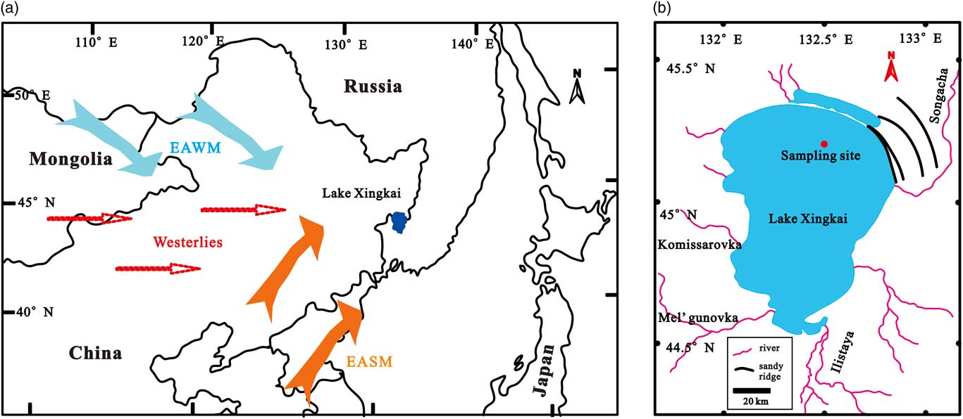
Figure 1 (a) Map showing the location of Lake Xingkai in northeast Asia (blue dot) and the dominant atmospheric circulation systems of East Asia (EASM, East Asian summer monsoon; EAWM, East Asian winter monsoon). (b) Map showing the catchment of Lake Xingkai and the drilling site (red dot). (For interpretation of the references to color inn this figure legend, the reader is referred to the web version of this article.)
The climate of Lake Xingkai has a distinct seasonality in both temperature and precipitation (Shen, Reference Shen2013; Wang et al., Reference Wang, Wang, Cheng, Fasullo, Guo, Kiefer and Liu2014; Long et al., Reference Long, Shen, Wang, Gao and Frechen2015). In the summer, warm and humid air masses are transported by southwesterly winds from the western tropical Pacific; while in the winter, the climate is affected by the extremely dry and cold northwesterly winter monsoon caused by the Mongolia-Siberian High. Instrumental data available from the adjacent Jixi meteorological station (~120 km east of Lake Xingkai) indicate a mean annual temperature of 3°C with a maximum monthly mean temperature of 21°C in July and a minimum monthly mean of temperature −18°C in January. Mean annual precipitation is ~540 mm, around 70% of which falls between June and September. From late October to April, Lake Xingkai is covered by ice.
MATERIAL AND METHODS
In summer 2008, two parallel and overlapping sediment cores (XK08-A1 and XK08-A2) were collected from a water depth of 7 m near the China-Russia boundary (Fig.1b; 45°12′21“N, 132°30′33” E) using a UWITEC piston corer. In the laboratory, core correlation between XK08-A1 (308 cm long) and XK08-A2 (336 cm long) was carried out using surface scanning magnetic susceptibility as well as core XK-1 retrieved previously from the same site in summer 2007 (Wu and Shen, Reference Wu and Shen2009) as a reference. Subsequently, core XK08-A1 was split under subdued red light in a dark room and sectioned at 5–10 cm intervals for optically stimulated luminescence (OSL) dating. A total of 49 OSL samples were obtained (Long et al., Reference Long, Shen, Wang, Gao and Frechen2015). Core XK08-A2 was split into two halves and visually described in the field. The cores are mainly composed of fine-grained, grayish, minerogenic, organic-poor sediments. Coarse sands appear at 251–255 cm deep in Core XK08-A2. The working half of Core XK08-A2 was sectioned at 1 cm intervals, and the samples were stored at 4°C in the repository prior to analysis.
Because radiocarbon dating using the AMS method might be problematic for samples older than 30 cal ka BP, the chronology of cores XK08-A2 and XK-1 is mainly based on the correlation of the magnetic susceptibility with Core XK08-A1 dated using the OSL method (Fig. 2). The relationship between OSL ages and depth of Core XK08-A1 suggests that there are at least four sedimentary hiatuses in Lake Xingkai. Within dating errors, these occurred at 86.5 ± 11.2–65.5 ± 8.6, 53.3 ± 7.0–31.6 ± 4.1, 19 ± 2.5–8.2 ± 1.1, and 8.2 ± 1.1–0.4 ± 0.5 ka, respectively (Long et al., Reference Long, Shen, Wang, Gao and Frechen2015). The upper 288 cm of sediments of Core XK08-A2 are well correlated with that of Core XK 08-A1 (Fig. 2). However, the OSL dating errors are relatively large for samples older than 55 ka, which may hinder assignment of the boundaries of MIS stages directly. It is worth noting that, during the last glacial-interglacial cycle, the sediment magnetic susceptibility of the cores shows low values during the warm periods (mid-Holocene and the last 0.4 ka) and high values during cold periods (MIS 4, early MIS 3, and MIS 2) . On the basis of this relationship, we further align the high magnetic susceptibility at 216–253 and 288–336 cm depth to MIS 5c and MIS 5e, respectively, and low magnetic susceptibility at 253–288 cm depth to MIS 5d (Table 1). In addition, a new AMS 14C age on twigs at 64 cm depth of core XK08-A2 was dated to about 26.5 cal ka BP, which is consistent with the OSL age, further supporting that the OSL signals are fully bleached and the OSL dates are reliable (Long et al., Reference Long, Shen, Wang, Gao and Frechen2015).
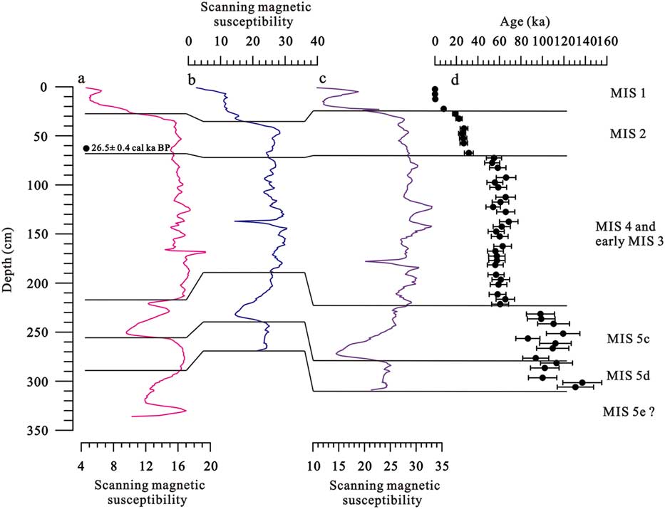
Figure 2 (color online) Correlation of (a) core XK08-A2 and(b) XK-1 with (c) the adjacent core XK08-A1, which was dated using the (d) optically stimulated luminescence method (Long et al., Reference Long, Shen, Wang, Gao and Frechen2015).
Table 1 Depth (cm) and the corresponding Marine Isotope Stage (MIS) of Lake Xingkai sediment cores.

Samples for grain-size analysis were taken from Core XK08-A2 at 1 cm intervals. The samples were first treated with 30% H2O2 at 75°C to remove organic matter, and then 10% HCl was added to remove carbonates and iron oxides. Subsequently, the samples were rinsed to neutral, and treated with 20 mL of 0.05 M (NaPO3)6 and dispersed using an ultrasonicator for 15 min. Grain-size distribution of the samples was measured using a Mastersizer 2000 laser grain-size analyzer ranging from 0.02 to 2000 μm and yielding 100 pairs of grain-size data. Every sample was measured three times and the mean was calculated and used for the analysis. The analytical error of the measurements is less than 1%. The median diameter (Md, the diameter at the 50th percentile of the distribution) and the percentages of clay (<2 μm), silt (2–63 μm), and sand (>63 μm) fractions of a sample were generated automatically. The original grain-size distributions of Core XK08-A2 were transferred into unmixed end members by BEMMA using a Markov Chain Monte Carlo algorithm (Yu et al., Reference Yu, Colman and Li2016). BEMMA is a hierarchical Bayesian model within the framework of Bayesian inference. To identify the number of end members, a birth-death process is used to browse the parameter space, while for the end member and fraction matrices, the Metropolis-Hastings-Green-within-Gibbs algorithm is used to deal with the move of the Markov chains and to update the model parameters and their hyperparameters (Yu et al., Reference Yu, Colman and Li2016). The end-member modeling was implemented in MATLAB R2012b.
RESULTS
The grain-size composition of lithic particles of Lake Xingkai sediments is shown in Figure 3a. The sediments are mainly composed of silt, with a content ranging from 61.9 to 93.8%, with a mean of 89.0%. The trend of the clay content is negatively correlated with that of silt, ranging from 5.1 to 19.8%, with a mean of 10.7%. The sand fraction is extremely low in Lake Xingkai sediments, but its content reaches as high as 33.0% at 254 cm deep. The Md values range from 5.0–15.6 μm, with a mean of 9.1 μm.

Figure 3 (color online) Results of grain-size analysis of core XK08-A2. (a) Variations in the median grain size, fraction of clay, silt, and sand, as well as the fraction of each EM 1-3 output from BEMMA. (b) Grain-size distributions of representative samples. (c) Grain-size distribution of EM 1-3 obtained from BEMMA.
Representative grain-size distributions from Lake Xingkai sediments are shown in Figure 3b. The data are characterized by polymodal and asymmetrical forms. The first one is composed of two overlapping fine-grained particle populations with a modal size of 2 μm and 8 μm, respectively. The second popualtion is mainly composed of silt with a modal size of 10–20 μm and a small amount of fine-grained material. The third population is discontinuous, and shows a silt mode similar to the second type and an extremely coarse component with a modal size of 400–500 μm. However, this kind of distribution is rare and it only appears in several samples.
After a short burn-in period, the BEMMA model converges at three grain-size end members for Lake Xingkai sediments (Fig. 3c). The first end member (EM1) is characterized by a bimodal structure with a dominant mode at around 13 μm and a minor mode at around 2 μm. The fraction of EM1 ranges from 2.4 to 89.5%, with a mean of 19.3% (Fig. 3a). The second end member (EM2) is marked by an asymmetrical monomodal structure with a mode at around 10 μm. The fraction of EM2 ranges from 2.0 to 95.3%, with a mean of 60.0% (Fig. 3a). The third end member (EM3) also exhibits an asymmetrical monomodal structure, but with a dominant mode at around 5 μm. The fraction of EM3 ranges from 1.5 to 94.7%, with a mean of 20.7 % (Fig. 3a).
DISCUSSION
Interpretation of the grain-size end members
The grain-size composition of lacustrine sediments is influenced by sources and transport processes (Xiao et al., Reference Xiao, An, Liu, Inouchi, Kumai, Yoshikawa and Kondo1999; Xiao et al., Reference Xiao, Chang, Si, Qin, Itoh and Lomtatidze2009; Xiao et al., Reference Xiao, Chang, Fan, Zhou, Zhai, Wen and Qin2012; Xiao et al., Reference Xiao, Fan, Zhou, Zhai, Wen and Qin2013; Dietze et al., Reference Dietze, Maussion, Ahlborn, Diekmann, Hartmann, Henkel, Kasper, Lockot, Opitz and Haberzettl2014). Determined by the geographic location and inflowing rivers, detrital particles in Lake Xingkai sediments would be expected to mainly be derived from materials transported by the rivers and streams during the rainy season and atmospheric dust deposits during the dry and windy spring season when the lake is covered by ice. To some extent, the unconsolidated sand near shorelines and reworked by the wind-driven waves could also contribute to the accumulation of clastic deposits in the lake.
Previous studies suggest that the two types of clastic sediments exhibit different fractions of mixing of specific grain-size components due to distinct transport dynamics. For example, fluvial sediments in northeast China are mainly composed of bed load sand with a dominant modal size of 100–400 μm and suspension fine silt with a dominant modal size of 10–15 μm (Xiao et al., Reference Xiao, Chang, Fan, Zhou, Zhai, Wen and Qin2012, Reference Xiao, Fan, Zhou, Zhai, Wen and Qin2013). However, the grain-size distribution of the fluvial component is also closely related to hydraulic conditions, so that the relative abundance would be highly modified by high and low hydrodynamics during the deposition process in the lake (Finney and Johnson, Reference Finney and Johnson1991). Generally, the sand component occurs only in the nearshore zone, where shallow water possesses high energy, and its relative abundance decreases significantly as water depth increases. The relative percentage of the fine silt component is considerably lower in the nearshore zone than the center of the lake (Xiao et al., Reference Xiao, Fan, Zhou, Zhai, Wen and Qin2013). In Lake Xingkai, EM1 and EM2, with a dominant modal size of 13 and 10 μm, respectively, are consistent with the modal size of fluvial source. This suggests that EM1 and EM2 were transported by the riverine inflows and can be used as proxies for the hydraulic dynamics of Lake Xingkai. Lake level variation history could also be reconstructed through beach ridges (Thomas et al., Reference Thomas, Bailey, Shaw, Durcan and Singarayer2009; Rades et al., Reference Rades, Hetzel, Xu and Ding2013). Based on the characteristics of the grain-size distribution, the ridges around Lake Xingkai are aeolian, not wave-built or lacustrine sedimentary formations, and the age of the ridges can be used as an indicator of regressional periods (Zhu et al., Reference Zhu, Shen, Lei and Wang2011; Long and Shen, Reference Long and Shen2017). New ages for the sandy ridges around Lake Xingkai suggests that a distinct period of lake lowstand occurred at ~32–15 ka (Long and Shen, Reference Long and Shen2017). However, the sediments from this period are dominated by EM2 and characterized by fine silt. Therefore, considering the absence of the nearshore sedimentary characteristics, the variation of lake level would not influence the hydraulic dynamics significantly at the coring location since the last interglaciation.
Increased precipitation could enhance the transport capacity of rivers and streams, leading to a coarser grain size in the center of the lake (Chen et al., Reference Chen, Wan, Zhang, Zhang and Huang2004). Thus, the modal size of the fine silt component may reflect precipitation intensity in the watershed of the lake: a higher percentage of the silt-size fraction and an increase in the grain size would reflect intensified precipitation rates (Peng et al., Reference Peng, Xiao, Nakamura, Liu and Inouchi2005). Because the precipitation at Lake Xingkai is mainly determined by the EASM, we infer that EM1 was transported to the lake by rivers and streams during heavy rainfall influenced by the intensified EASM, while EM2 was transported to the lake by meltwater in spring or during rainfall when the EASM retreated from the lake region. Assuming a similar content of suspended particles in the inflows, we interpret the ratio of EM1 to the sum of EM1 and EM2 fractions of Lake Xingkai sediments as a proxy index for past changes in the EASM intensity. Specifically, the higher the EM1 / (EM1 + EM2) ratio, the stronger the EASM and thus the summer precipitation in the lake region.
Modern observations and lacustrine varve characteristics suggest that atmospheric dust is also an important component of lacustrine sediments in middle latitudes of the northern Hemisphere (Liu et al., Reference Liu, Dong, Yang, Herzschuh, Zhang, Stuut and Wang2009; Xiao et al., Reference Xiao, Chang, Fan, Zhou, Zhai, Wen and Qin2012; Chen et al., Reference Chen, Qiang, Zhou, Xiao, Chen and Sun2013; Xiao et al., Reference Xiao, Fan, Zhou, Zhai, Wen and Qin2013; Dietze et al., Reference Dietze, Maussion, Ahlborn, Diekmann, Hartmann, Henkel, Kasper, Lockot, Opitz and Haberzettl2014). The particle size distribution of EM3 is similar to dust samples collected from recent dust events; for example, the 2002 dust storm in the Longgang area and the 2011 wet deposited dust in Harbin in northeastern China (Fig. 4a; Chu et al., Reference Chu, Sun, Zhaoyan, Rioual, Qiang, Kaijun, Han and Liu2009; Xie et al., Reference Xie, Chi, Meng, Guo and Wang2015). EM3 is also similar to the grain-size distribution of the fine component of the Chinese loess-paleosol deposits, aeolian sediments in Cheju Island, Korea, and North Pacific deep-sea sediments (Fig. 4b–d; Rea and Hovan, Reference Rea and Hovan1995; Lim and Matsumoto, Reference Lim and Matsumoto2006; Sun, Reference Sun2004; Serno et al., Reference Serno, Winckler, Anderson, Hayes, McGee, Machalett, Ren, Straub, Gersonde and Haug2014). These lines of evidence suggest that EM3 in Lake Xingkai sediments represents an aeolian dust origin. However, different grain-size fractions have been used to trace the dust deposits in lake sediment, such as sand fraction of 56–282.5 μm in Lake Sugan in the Qaidam Basin and fine silt (<10 μm) quartz particles in Lake Biwa in central Japan (Xiao et al., Reference Xiao, An, Liu, Inouchi, Kumai, Yoshikawa and Kondo1999; Chen et al., Reference Chen, Qiang, Zhou, Xiao, Chen and Sun2013). This difference may be attributed to different sorting mechanisms during wind transport and deposition processes. Theoretically, particles larger than 70 μm would retained in the aeolian source area; the fraction with average grain size 10–70 μm is transported by surface winds to a distance about 250 km; and the fine component (average grain size of <10 μm) is mainly transported by upper-level air flow in long-term suspension (Tsoar and Pye, Reference Tsoar and Pye1987; Sun et al., Reference Sun, Su, Bloemendal and Lu2008). Therefore, lakes near the dust source area would receive more of the sand fraction, while lakes in humid area are mainly influenced by fine dust. In addition, the surfaces of sandy ridges around the lake are covered by vegetation in summer and freeze from winter to spring, the near shoreline materials that could be transported by wind to the center of the lake would be limited. Lake Xingkai is blocked by Changbai Mountains and distant from the arid and semiarid zones in north China and the Mongolian Gobi in the west, thus, the fine silt component EM3 seems to be very sensitive and strongly related to dust activity, and this fraction can be used to indicate that the dust is derived from Mongolia and the northeastern Chinese sand areas.

Figure 4 (color online) Comparison of the grain-size distribution of EM3 with that of aeolian dust elsewhere. (a) Wet-deposition dust in Harbin, NE China (green line; Xie et al., Reference Xie, Chi, Meng, Guo and Wang2015). (b) Westerly-delivered dust in North Pacific Ocean (black lines; Serno et al., Reference Serno, Winckler, Anderson, Hayes, McGee, Machalett, Ren, Straub, Gersonde and Haug2014). (c) Loess from the Chinese Loess Plateau (red line; Sun et al., Reference Sun, Bloemendal, Rea, Vandenberghe, Jiang, An and Su2002). (d) Aeolian quartz in Cheju Island, Korea (red line; Lim and Matsumoto Reference Lim and Matsumoto2006). The dashed lines in (c) and (d) represent the fine and coarse components obtained by fitting using the Weibull distribution function. (For interpretation of the references to color inn this figure legend, the reader is referred to the web version of this article.)
Evolution of the East Asian summer monsoon
Aspects of the history of the EASM evolution since 130 ka BP can be inferred from the proxy defined as EM1 / (EM1+EM2) from Lake Xingkai (Fig. 5a). The moisture history can be divided into three stages: (1) a generally strong EASM interval during MIS 5 with a phase of weak EASM corresponding to MIS 5d; (2) an interval of weakening EASM from MIS 4 to MIS 2; and (3) a moist period during MIS 1. Pollen data from core XK-1 revealed a similar moisture history. For example, the rapid increase in tree pollen percentages from MIS 5d to 5c suggests that the climate became warm and humid; from MIS 4 to MIS 2, the forest in the adjacent mountains retreated and local vegetation was replaced by Chenopodiaceae-dominated steppe, indicating that the climate become cold and dry; the highest pollen percentages of thermophilous Quercus, Pinus, and Ulmus indicate a relatively strong EASM during MIS 1 (Wu and Shen, Reference Wu and Shen2010a). The pattern of changes in the EASM during the last glacial-interglacial cycle is consistent with other records from the EASM region. During the last interglaciation and the Holocene, for instance, high magnetic susceptibility values suggest intensified pedogenesis in the Chinese Loess Plateau (Fig. 5c; An et al., Reference An, Kukla, Porter and Xiao1991); high fluvial quartz fluxes indicate an increased amount of clastic material entering the Lake Biwa in Japan from the catchments (Fig. 5d; Xiao et al., Reference Xiao, An, Liu, Inouchi, Kumai, Yoshikawa and Kondo1999); paleo-shorelines dated by OSL show high lake levels occurring in northwestern China (Long et al., Reference Long, Lai, Fuchs, Zhang and Li2012; Lai et al., Reference Lai, Mischke and Madsen2014; Li et al., Reference Li, Jin, Duan, Madsen, Li, Yang, Wei and Chen2015); and the lower oxygen isotope values of cave carbonates in central China suggest increased summer monsoon precipitation (Fig. 5e; Wang et al., Reference Wang, Cheng, Edwards, An, Wu, Shen and Dorale2001, Reference Wang, Cheng, Edwards, Kong, Shao, Chen, Wu, Jiang, Wang and An2008). During the last glaciation, pedogenesis in the Chinese Loess Plateau was weakened, the amount of clastic materials entering Lake Biwa from the surrounding areas decreased, lakes in northwestern China were at very low levels, and a decrease in summer monsoon precipitation is also indicated by high oxygen isotope values from cave carbonates in central China (An et al., Reference An, Kukla, Porter and Xiao1991; Xiao et al., Reference Xiao, An, Liu, Inouchi, Kumai, Yoshikawa and Kondo1999; Wang et al., Reference Wang, Cheng, Edwards, An, Wu, Shen and Dorale2001, Reference Wang, Cheng, Edwards, Kong, Shao, Chen, Wu, Jiang, Wang and An2008; Long et al., Reference Long, Lai, Fuchs, Zhang and Li2012; Lai et al., Reference Lai, Mischke and Madsen2014; Li et al., Reference Li, Jin, Duan, Madsen, Li, Yang, Wei and Chen2015). Furthermore, there are numerous short-term abrupt changes superimposed on the long-term trend of EASM intensity. Within the dating error, the oscillations also correspond to the reported intervals of abrupt EASM fluctuations since the last interglaciation inferred from the records of speleothems and loess-paleosol profiles in China (Porter and An, Reference Porter and An1995; Wang et al., Reference Wang, Cheng, Edwards, An, Wu, Shen and Dorale2001, Reference Wang, Cheng, Edwards, Kong, Shao, Chen, Wu, Jiang, Wang and An2008; Sun et al., Reference Sun, Clemens, Morrill, Lin, Wang and An2012).
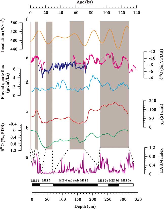
Figure 5 (color online) Comparison of the EASM index derived from core XK08-A2 grain size end members (a) with other climate records. (b) Reconstructed mean ocean water δ18O (Waelbroeck et al., Reference Waelbroeck, Labeyrie, Michel, Duplessy, McManus, Lambeck, Balbon and Labracherie2002). (c) Magnetic susceptibility from Luochuan in Chinese Loess Plateau (An et al., Reference An, Kukla, Porter and Xiao1991). (d) Fluvial quartz flux from Lake Biwa Japan (Xiao et al., Reference Xiao, An, Liu, Inouchi, Kumai, Yoshikawa and Kondo1999). (e) δ18O records of stalagmite from Sanbao and Hulu Cave in east China (Wang et al., Reference Wang, Cheng, Edwards, An, Wu, Shen and Dorale2001, Reference Wang, Cheng, Edwards, Kong, Shao, Chen, Wu, Jiang, Wang and An2008). (f) June insolation at 60°N (Berger and Loutre, Reference Berger and Loutre1991). Shaded intervals denote possible intervals during which EASM was reconstructed by Core XK08-A2.
Despite these changes inferred from fluvial processes, the sedimentary hiatuses of Lake Xingkai are in large part related to climate change. With weakened summer monsoon intensity, lakes in the monsoon region were characterized by low levels, which could trigger deflation and result in the formation of hiatuses in the sedimentary sequence (Jones et al., Reference Jones, Cook, Zhang, Langdon, Jordan and Turney2012). For Lake Xingkai, sedimentary hiatuses occurred at 8.2 ± 1.1–0.4 ± 0.5 ka and may be caused by the low lake level during the period 1.2–0.5 ka, which corresponds to the age of the sandy ridges (Long and Shen, Reference Long and Shen2017). The extreme droughts could have led to scouring of the lakebed and the renewal of lake sediment accumulation indicates the termination of the dry events. We therefore also infer that other sedimentary hiatuses of Lake Xingkai, which occurred at 86.5 ± 11.2–65.5 ± 8.6, 53.3 ± 7.0–31.6 ± 4.1, 19 ± 2.5–8.2 ± 1.1 ka, are possibly related to the significant weakening of the EASM during Heinrich events 6, 3, and 1 and the Younger Dryas, within dating uncertainties (Wang et al., Reference Wang, Cheng, Edwards, An, Wu, Shen and Dorale2001).
On the orbital scale, the grain-size record of the EASM from Lake Xingkai can be compared with summer insolation in the Northern Hemisphere during this interval (Fig. 5f; Berger and Loutre, Reference Berger and Loutre1991). In the study region, most of the annual precipitation falls in the summer when the monsoonal rain belt migrates to its northern limit. The increased solar insolation during the interglaciation would increase the sea-surface temperature of the west Pacific warm pool, and thus enhance the atmospheric pressure gradient between the ocean and the Eurasian continent, which, in turn, would intensify the penetration of the moist maritime airmasses into the interior of the continent. However, not only did solar insolation decrease during the glaciations, but the ice sheets in the high latitudes of the Northern Hemisphere also expanded (Fig. 5b; Waelbroeck et al., Reference Waelbroeck, Labeyrie, Michel, Duplessy, McManus, Lambeck, Balbon and Labracherie2002). During cold periods, the Arctic polar front and the westerlies moved southward as the ice sheets expanded, which would deflect the Intertropical Convergence Zone southward, leading to an anti-phased relationship between the EASM and the westerlies in the middle latitudes (An et al., Reference An, Colman, Zhou, Li, Brown, Jull and Cai2012). This interplay between the high- and low-latitude climate variability controls the hydroclimate regime in the middle latitudes of the Northern Hemisphere on orbital time scales.
Changes in the background atmospheric dust loading
As shown in Figure 6, the relative content of dust in the atmosphere from the last interglacial stage can be inferred using the changes in the fine fraction EM3 of Lake Xingkai sediments. The proxy indicates that dust was primarily deposited during the MIS 5d and from MIS 4 to early MIS 3. In contrast, dust loading in the atmosphere was generally low during MIS 2 and MIS 5e, 5c, and MIS 1. The generally higher atmospheric dust loadings from MIS 4 to early MIS 3 are consistent with the variation in sediment rate of loess-paleosol profiles in northeast China, the Chinese Loess Plateau, and northwest China based on high-resolution OSL chronology (Fig. 6d and f; Sun and An, Reference Sun and An2005; Yi et al., Reference Yi, Buylaert, Murray, Thiel, Zeng and Lu2015; Li et al., Reference Li, Rao, Duan, Xia, Wang, Madsen, Jia, Wei, Qiang, Chen and Chen2016), relatively high aeolian quartz flux in Lake Biwa in central Japan (Fig. 6e; Xiao et al., Reference Xiao, An, Liu, Inouchi, Kumai, Yoshikawa and Kondo1999), and high dust influx as recorded in marine sediments of the North Pacific (Rea and Hovan, Reference Rea and Hovan1995). During the weakened EASM period, decreased precipitation would significantly lower soil moisture and reduce vegetation cover on in the Asian arid areas, leading to higher rates of soil erosion (Fig. 6b). Meanwhile, many large lakes in northwestern China formed during the previous interglaciation dried, and deserts expanded in north China (Long et al., Reference Long, Lai, Fuchs, Zhang and Li2012; Lu et al., Reference Lu, Yi, Xu, Zhou, Zeng, Zhu and Feng2013; Lai et al., Reference Lai, Mischke and Madsen2014; Li et al., Reference Li, Jin, Duan, Madsen, Li, Yang, Wei and Chen2015), providing abundant fine silt and increasing dust emissions (Yang et al., Reference Yang, Yue and Li2008). In addition, the East Asian winter monsoon was greatly strengthened as indicated by the grain size of aeolian sediments in the Chinese Loess Plateau (Sun et al., Reference Sun, Clemens, Morrill, Lin, Wang and An2012). Therefore, large dust source areas and strong winter monsoon promoted the emission of dust, resulting in more dust deposition in the middle latitudes during cold periods.
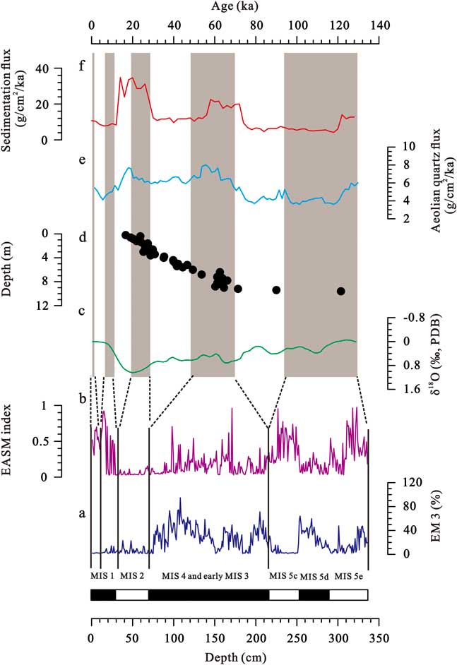
Figure 6 (color online) Comparison of the variations in atmospheric dust loading (a) with other regional conditions. (b) EASM index from Lake Xingkai (this study). (c) Reconstructed mean ocean water δ18O (Waelbroeck et al., Reference Waelbroeck, Labeyrie, Michel, Duplessy, McManus, Lambeck, Balbon and Labracherie2002). (d) Accumulation rate of Sanbahuo loess-paleosol profile in northeast China (Yi et al., Reference Yi, Buylaert, Murray, Thiel, Zeng and Lu2015). (e) Aeolian quartz flux from Lake Biwa, Japan (Xiao et al., Reference Xiao, An, Liu, Inouchi, Kumai, Yoshikawa and Kondo1999). (f) Sediment flux of Lingtai loess-paleosol profile from the central Chinese Loess Plateau (Sun and An, Reference Sun and An2005). Shaded intervals indicate possible intervals during which paleoenvironmental information was revealed by Core XK08-A2.
The EASM was weak and the resultant Asian dust source conditions were more favorable for dust emission during MIS 2. However, reduced vegetation cover under the weakened monsoonal circulation could not fully account for the inconsistent results of Lake Xingkai. In the Northern Hemisphere middle latitudes, the high-altitude westerlies were suggested to be the major carrier of fine dust (Nagashima et al., Reference Nagashima, Tada, Matsui, Irino, Tani and Toyoda2007; Kang et al., Reference Kang, Roberts, Wang, An and Wang2015). Nowadays, blocked by the Qinghai-Tibetan Plateau, the axis of the high-altitude westerlies is located to the south of the Himalayas from December to April, and then it moves to the northern margin of the Qinghai-Tibetan Plateau in early summer (Schiemann et al., Reference Schiemann, Lüthi and Schär2009). During the glacials, the southward migration of the mean position of the westerlies could affect the provenance and transport of aeolian dust in downwind of the Asian dust source areas (Nagashima et al., Reference Nagashima, Tada, Matsui, Irino, Tani and Toyoda2007; Kang et al., Reference Kang, Roberts, Wang, An and Wang2015). As the mean position of the axis of the westerlies is closely related to the Northern Hemispheric ice volume, the annually averaged westerlies axis during MIS 2 should be deflected southward when compared with that during MIS 5d, MIS 4, and early MIS 3 (Fig. 6c; Kitoh et al., Reference Kitoh, Murakami and Koide2001; Waelbroeck et al., Reference Waelbroeck, Labeyrie, Michel, Duplessy, McManus, Lambeck, Balbon and Labracherie2002). Therefore, it is reasonable to infer that there may have a lack of effective westerlies over Lake Xingkai during MIS 2, so the dust was mainly deposited in the Chinese Loess Plateau and the North Pacific between 35°N and 40°N. In contrast, during MIS 5d, MIS 4, and early MIS 3, the relative northward migration of the westerlies over the Mongolia Gobi and northeast China may have delivered a large amount of dust to Lake Xingkai.
CONCLUSIONS
The grain-size end-member unmixing program, BEMMA, was used to partition the polymodal grain-size distributions of Lake Xingkai sediments since the last interglaciation. The results suggest that the lacustrine deposits contain three overlapping end members with a modal size of 13, 10, and 5 μm, respectively. EM1 and EM2 are related to fluvial processes and the ratio of EM1 / (EM1+EM2) was sensitive to the variation of local hydroclimatic conditions, which are closely related to the EASM variations. The coherence between the EASM evolution and Northern Hemispheric insolation since the last interglaciation indicates that solar insolation may have regulated the hydroclimatic change in northeast Asia. EM3 is derived from atmospheric dust loading, and it reflects the background dust input to the lake. High atmospheric dust concentration in this area generally occurred in MIS 5d, MIS 4, and early MIS 3, when the climate was dry in the Asian dust source region. Low dust input prevailed in this area during MIS 2, due to the southward displacement of the westerlies driven by maximum ice-sheet expansion in the high latitudes. Our results suggest that the BEMMA method represents a powerful tool for the unmixing of the polymodal grain-size distributions of lacustrine sediments, which, in turn, deepens our understanding of the sedimentary processes of clastic materials in lake systems and the environmental conditions of the catchment during the geological past.
ACKNOWLEDGMENTS
We would like to express our gratitude to the editor and two anonymous reviewers for helpful comments that improved the quality of this manuscript. We also want to thank Dr. Yong Wang for field assistance and Dr. Jie Chang for correcting the English language. This research was supported by the National Natural Science Foundation of China (Grant Nos. 41430530 and 41621002) and the international partnership program for creative research teams of the Chinese Academy of sciences (No. KZZD-EW-TZ-08).


