

Introduction
The Tunisian–British Bulla Regia Project was established as a Society for Libyan Studies Flagship Project in 2014. It aims to investigate the Late Antique and early medieval history of the town of Bulla Regia in northern Tunisia. The site lies in the Medjerda Valley on the route between Carthage and Hippo in Africa Proconsularis (Figure 1). Probably one of the residences of the Numidian kings, it dates back to at least the fourth century BC. Bulla Regia became an ‘oppidum liberum’ with the creation of the province Africa Nova in 46 BC (Pliny HN 5.25), and was elevated to municipium probably under Vespasian, and to colonia under Hadrian. As a wealthy town which provided Rome with many senators and equestrians, it contains all the usual monuments of a Roman town but is perhaps more renowned for its lavishly decorated fourth to fifth century AD houses with cool underground rooms, floored with mosaics (Thébert Reference Thébert1973). Christianity is attested at the site as early as 256 when one Therpaius is mentioned as bishop (Sent. Episc. 61), and by the late fourth century, Bulla seems to have had a substantial Christian population: just before Easter 399, its Christian inhabitants were famously rebuked by Augustine (Serm 301A) for attending the theatre and holding lavish theatrical spectacles too frequently, and both Donatist and Catholic bishops from the city attended the Council of Carthage in 411. In total, eight bishops are attested in the written sources between the third and early eighth century, attesting to a long and complex Christian history that also continued after the Arab conquest of Carthage in 697/8.Footnote 1

Figure 1. Plan of Bulla Regia based on excavations and geophysical survey (Corisande Fenwick).
Despite the obvious importance of Bulla Regia for the history of Christianity in northern Tunisia and the transition from Late Antiquity to the Middle Ages, this aspect of the town has received little archaeological attention. Dr L. Carton was the first to find evidence of Christian activity while excavating the so-called ‘Church of Alexander’ in 1914, an enigmatic building of the sixth to seventh century which had a door lintel inscribed with Psalm 120 (line 8) and a variety of finds including a Byzantine cross dedicated by the priest Alexander and a reliquary (Carton Reference Carton1915). He later identified a second possible church (now reburied) and a handful of Christian graves in a bath complex in the NE of the site (Carton Reference Carton1922, 175). In 1952–54, an ‘episcopal’ complex of two churches (Church 1 and Church 2) was excavated by P. Quoniam, but published 15 years later by N. Duval (Reference Duval1969) only in summary form, based on the excavation archive and his own observations. In 2010, a preventative excavation directed by M. Chaouali uncovered a hitherto-unknown church and Christian cemetery to the west of the large pagan cemetery on the west side of the town. Further evidence for the Christian population comes from a mosaic decorated with the four rivers of Paradise and a biblical inscription (Gen. 28, 17) in House 10, probably dating to the fifth century (Hanoune Reference Hanoune and Beschaouch1983), and a possibly Christian cemetery consisting of a series of graves cut into various houses in the north of the site at some point after the second half of the sixth century (Leone Reference Leone, Stone and Stirling2007, 175–76). Significantly, Bulla Regia continued to be occupied in some manner until at least the twelfth century, as is attested by medieval ceramics and coin hoards (Thébert Reference Thébert1983). The continued practice of Christianity under Muslim rule, already suggested by the eighth-century bishop from Bulla Regia, is lent further support by the discovery of a late infant burial in Church 1 that contained a small hoard of Umayyad coins (Duval Reference Duval1969, 220, 229).
To explore these issues, a collaborative project between the Institut National du Patrimoine (INP) and University College London (UCL) was established. It combines multiple techniques – remote sensing, photogrammetry, excavation and bioarchaeological analysis – to reconstruct the urban development of Bulla Regia from Late Antiquity to its abandonment in the Middle Ages, the development of Christianity at the site, and to understand the diet, nutrition, health, lifestyle, origins and mobility of its Late Antique inhabitants. In response to the challenges of conducting fieldwork in Tunisia at present, our methodology prioritises non-invasive rapid documentation techniques such as photogrammetry and geophysics, inventory of excavated finds, supplemented by targeted small-scale excavations where possible. Fieldwork was postponed several times in 2014 and 2015 because of the security situation in the region of Jendouba. A short campaign of geophysical prospection and topographic survey was conducted in 2016 and the first season of rapid documentation with limited excavation in 2017. This report presents the preliminary results of our fieldwork at the newly discovered Christian complex and cemetery. It provides an example of the possibilities that new, inexpensive technologies such as photogrammetry offer archaeologists for rapidly documenting and analysing monuments when it is impossible to conduct long fieldwork campaigns.
The church and the western cemetery
The newly-discovered church is located outside the protected site of Bulla Regia in an area which contains several visible funerary monuments, including early Roman mausolea, a recently excavated funerary enclosure with a mixture of inhumation and cremation burials, and a Muslim cemetery and marabout. This zone is known as the western cemetery: it lies north of the modern main road where it comprises a large, uncultivated field and extends up into the olive tree-covered lower slopes of the hills behind the site, below a Roman temple. A wadi diverted into a modern spring runs down its eastern flank, but the cemetery seems to have extended beyond it.
The earliest explorers to the site in the 1850s (C. Tissot, A. Winkler, H. Saladin and R. Cagnat) recognised the presence of a large pagan cemetery in this area and described or marked on their plans a series of Roman mausolea outside the walls of the town (the existence of these walls is disputed; see Antit et al. Reference Antit, Broise, Thébert and Beschaouch1983, 137–41), near the main roads west and south to Chemtou (Figure 2). Most of our knowledge of the western cemetery comes from Carton's excavations in 1899, 1890 and 1892 (Carton Reference Carton1890a; Reference Carton1890b). He excavated several mausolea and tombs (perhaps as many as 175) in a series of as yet unlocated trenches on the plain and lower slopes. The mausolea and graves of this early cemetery were marked by masonry and stone cupulae, steles or cippi, and sometimes placed in walled enclosures (areae). Most of the cupulae, steles and cippi had funerary inscriptions, of which he recorded 144. Whilst Carton did uncover some inhumations, most of the burials had been cremated in situ (Carton Reference Carton1889). The use of this cemetery extends from the first century AD (and perhaps earlier) into at least the first quarter of the fourth century (Carton Reference Carton1890a, 183).

Figure 2. Carton's plan of the western cemetery (Carton Reference Carton1890a, 151, fig. 1).
During the 1960s and 1970s, further work took place under the auspices of a French–Tunisian team. A further 10 cupola tombs covering cremation burials dated to the early second century AD were excavated near the wadi by R. Hanoune in 1968 and M. Khanoussi in 1974 and 1978 (Khanoussi Reference Khanoussi and Beschaouch1983). The French–Tunisian survey planned and mapped much of the environs of Bulla Regia: they (re-)identified multiple standing mausolea in the western cemetery, many of which had previously been noted by Carton and Winckler (Antit et al. Reference Antit, Broise, Thébert and Beschaouch1983, 148–51). Their survey showed that the cemetery extended as far as the Roman temple to the north and continued on to the eastern side of the wadi as far as the modern road that bounds the site. In addition, they identified a small mound (C31) in the far west of the field, about 15 metres in diameter, with no visible architecture, but containing fragments of marble slabs, a bowl of Chemtou marble (now lost) and African sigillata (A and D) (Antit et al. Reference Antit, Broise, Thébert and Beschaouch1983, 150). The remains were interpreted as a farm on the outskirts of the cemetery, rather than a mausoleum.
Rescue excavations directed by M. Chaouali in 2010 in the area of the western cemetery in response to a proposed housing development produced two discoveries: (1) a large church complex and cemetery enclosure on the mound (C31), surrounded by further tombs and at least one Late Antique below-ground mausoleum; (2) a Roman funerary enclosure with a mixture of inhumation and cremation burials, probably first to fourth century in date, in the east of the cemetery. These discoveries raised important questions about the extent of the pagan cemetery and the size of the church complex and Christian cemetery.
In September 2016, we undertook a geophysical survey of 6.49 ha with a modified fluxgate magnetometer on a quadbike (Figure 3). The results were disrupted in the zone around the church by modern ferrous debris and spoil, and as yet, we do not understand the spatial or chronological relationship between the Christian church and cemetery in the west and the Roman mausolea and graves excavated in the east. Nonetheless, the survey revealed a complex funerary landscape consisting of further mausolea, graves and funerary enclosures that extend significantly to the west and south of Carton's excavations and the standing mausolea. The strongest anomaly corresponds to a large quadrangular structure (20 × 54 m) and open to the SE, which we interpret this as a funerary enclosure similar to Z4 to its north-east, and located on the same orientation. A second small rectangular structure of 7 × 6 m with a positive magnetic anomaly at its centre may be a cremation. To the north, a group of three significant anomalies represent stone-built mausolea similar to those that still are visible above ground. Numerous smaller circular anomalies in the south likely correspond to graves with cremations in situ. The survey also revealed three linear parallel anomalies in the direction N 330. They are separated by 57 m. If one extrapolates to the north, there is no trace of a fourth line, but a fifth line is visible 106 m away. Whilst these do not correspond to a multiple of the actus (35.5 m), we identify these as either traces of cadastration that pre-date the pagan cemetery and church or later medieval or pre-modern field boundaries. The results thus reveal an extensive cemetery, which we estimate covers approximately c. 16–22 ha.

Figure 3. Plan of western cemetery showing church and geophysics (Michel Dabas).
The church
The church and cemetery lie 475 m to the west of the Byzantine fort and are oriented ENE-WSE, the same orientation as the ‘episcopal’ complex inside the town some 525 m away (Figure 4). The rescue excavations in 2010 uncovered a church with several funerary annexes and chapels. Many of these were used for burial and several important tomb mosaics and inscriptions were uncovered and lifted during the rescue excavations, including those of two priests and two bishops, and a double mosaic depicting scenes from the story of Jonah and the whale. Our primary aim in the short 2017 season was to fully document and analyse the church, its decoration and the surrounding cemetery in order to understand its phasing.

Figure 4. Plan of church and cemetery (Corisande Fenwick).
The church and cemetery were recorded in their totality in high-resolution photographs and transformed into three-dimensional models using the photogrammetric software Agisoft Photoscan 1.3.4. In order to ensure that the models were accurate, we undertook a targeted topographic survey. In the post-excavation season, georeferenced orthomosaics from the photogrammetry were used to produce full plans. The potential of basic photogrammetric techniques to rapidly document and monitor the condition of excavated buildings is demonstrated by the high quality of the plans; however, it must be emphasised that the processing and digitisation of the 3-D models on high-speed computers took considerable time and labour in the UK.
The church follows the typical plan of North African basilica: the quadratum populi (Room 5; length 14; width 12 m) is divided into three naves of identical width leading onto a central apse (Figure 5). It is constructed in opus africanum. The dominant stone is a local grey limestone with many thin brown veins and the occasional quartz inclusions. However, architectural elements are in a variety of different stones, including a local dark beige limestone, a local dark green schist, a hard green slate, or a brownish red limestone with thin light veins and large grey patches. Many of the architectural elements (columns, capitals, architraves), as well as some of the material for the walls, were reused from earlier Roman buildings and the pagan cemetery (fragments of pagan funerary stele or altars are visible in some of the walls).
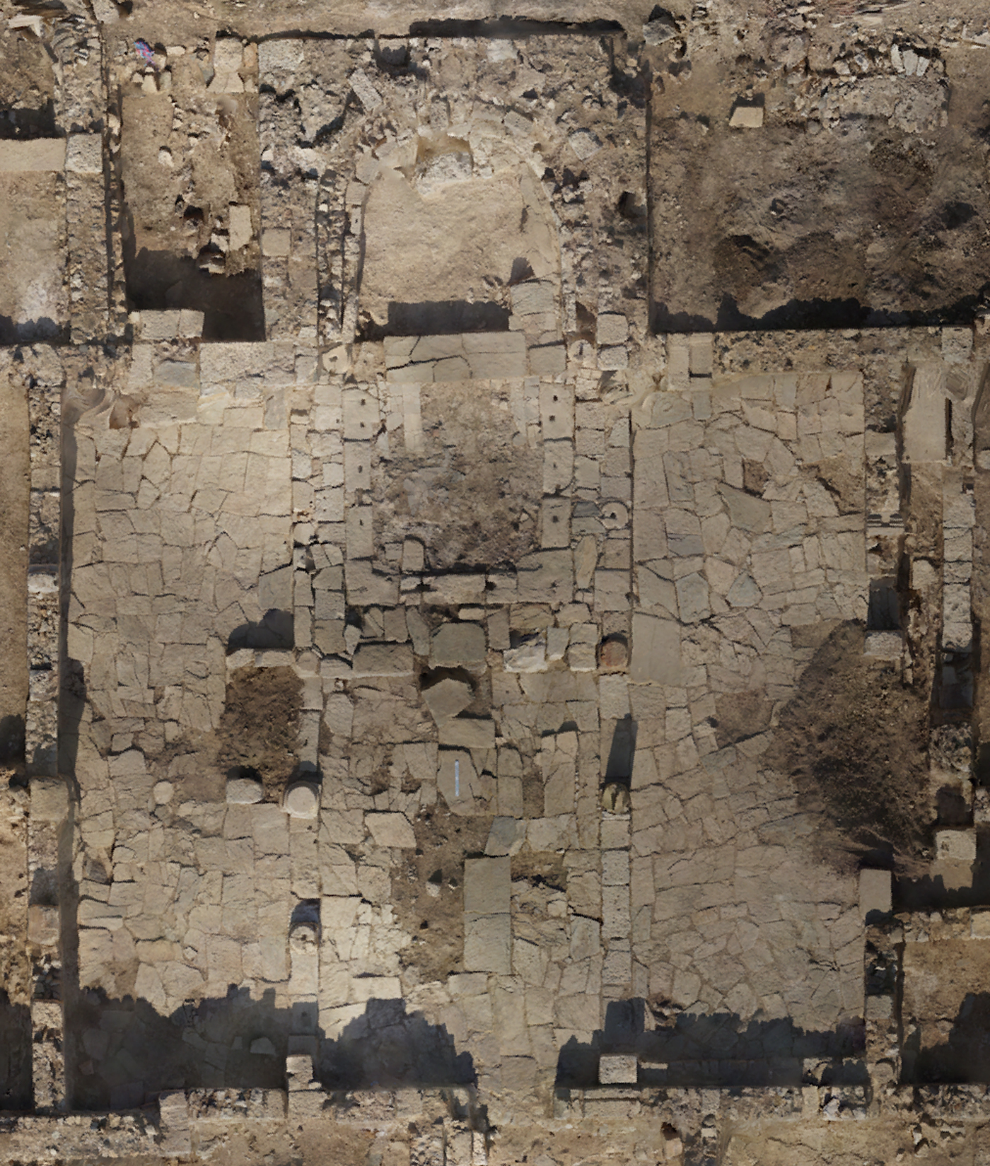
Figure 5. Orthophoto of the church and three naves. (Photo: Gai Jorayev)
The naves are divided by two stylobates, each originally holding six columns. Six column bases, all Attic, have survived in situ, while the bottom parts of two columns erected without a base are also still present. Most of the columns were in the local medium grey limestone with brown veins and quartz inclusions, though some are in white marble (most likely Proconnesian) and one in cipollino. Four identical composite capitals said to come from this area of the church probably belonged to one single building, before their reuse. The bases, however, were in four different materials, and of widely varying dimensions, supporting the interpretation that most, if not all, of the bases and columns were reused.
The raised choir in front of the apse has several phases (Figure 6). The earliest of these consisted of a central ciborium. This is located at the NE end of the central nave, comprising a square foundation with dowels for the placement of columns at the four corners (Figure 7a). The square area defined inside the ashlar foundation of the ciborium had a mosaic floor (of which only traces survive) where, presumably, the altar stood, and marble opus sectile covered a step into the apse. In a next phase, a chancel screen (the grooves for the posts are visible in the foundation) replaced the ciborium, whose raised foundation was encapsulated in a larger platform that also integrated six of the 12 nave columns. The core of the platform, where originally the mosaic floor had been, was now covered in reused fragments of marble opus sectile. It is likely that at this time also the apse took its current form, either being built newly or monumentalised from the earlier phase (Figure 7b and 7c).

Figure 6. The interior of church showing the three naves of the quadratum populi with the chancel arrangement and the apse behind. (Photo: Corisande Fenwick)

Figure 7. A: Reconstruction of ciborium in phase 2. B: Reconstruction of chancel in phase 3. C: Reconstruction of church in phrase 3 (Dirk Booms).
The apse was entered from the platform by a large step in green-grey slate, flanked by two columns. It contains a synthronos of two steps in ashlar blocks. Part of the pavement survives; it consists of irregularly sized large coloured slabs (green and red). One of these contains a graffito of a kantharos. Towards the rear of the apse, a feature of large ashlar blocks might have been a throne or steps to get to the tabernacle, the base of which is still visible at the back of the apse.
The pavement of the quadratum populi is one of the latest additions and consists of thin slabs of varying size. No graves seem to have been cut through this new pavement, which is unusual for North African churches. However, below the flagstone pavement, a modern robber pit (cleaned up as Sondage 3) revealed a fragment of a mosaic tomb cover approximately 5 cm below the slabs, while much deeper, at a depth of 1.8 m, several layers of cist tombs are visible in the section. It seems likely that there are substantial numbers of tombs below the current pavement of the church and that in an earlier phase burials did take place within the quadratum populi.
The main entrance is in the south and comprises an entrance corridor (Room 11) with threshold stones still in situ. We hypothesise, however, that the church may originally have had one or three entrances on the west side, opposite the apse, which were destroyed when the funerary chapel of the bishop Procesius (Room 12) was constructed. This is one of the latest additions to the church (Figure 8). It is an almost square room of 6 × 5.5 m with bonded walls in opus africanum, built on the west side of the quadratum populi, off-centre. Its construction, which entailed a complete rebuilding of the church's western façade, damaged several graves with mosaic covers in the cemetery enclosure outside. In the centre of the room was a large, cracked grave slab with an epitaph marking the burial of the bishop Procesius who died at the age of 30 years and is otherwise unknown to historical record (Chaouali Reference Chaouali, Bockmann, Leone and von Rummelforthcoming). Further tombs, including one in a lead sarcophagus filled the remainder of the room, but unlike most of the other annexes, there are no mosaic tomb covers in this room.

Figure 8. Chapel of Procesius (Room 12) with epitaph in situ in 2010. (Photo: Moheddine Chaouali)
Southern annexes
To the south, the main entrance corridor is surrounded by a group of three or four rooms serving as ancillary chapels or funerary annexes to the church.
An entrance leads off the south nave of the church into a small anteroom (Room 7) with fragmentary mosaics, which gave onto an apsed chamber (Room 8). Room 7 is a rectangular room with internal measurements of 7.5 by 3.75 m, with fragmentary traces of funerary mosaics. Whilst most of its walls are in opus africanum, its northern wall incorporates an earlier thickly mortared stone wall with deep foundations of a completely different masonry type. A monumental entrance, consisting of two flanking piers with two columns in between, framed the apse, which had a synthronos of one step (Figure 9). None of the original pavement survives: the apse was given over to burials in a series of stone cist graves and sarcophagi. Most of these were excavated in 2010 and some have subsequently been vandalised. Our current interpretation sees these rooms as the earliest surviving structures of the complex, since they incorporate the earliest datable walls so far discovered. It is therefore possible that these two rooms were part of an earlier church complex, a baptistery, or a monumental funerary chapel or mausoleum, which we hope to clarify through further excavations.

Figure 9. Interior of side chapel (Rooms 7 and 8). (Photo: Corisande Fenwick)
The entrance corridor gave on to a small room (Room 11) of c. 3.5 by 6 m which served as a funerary chapel. Partially excavated in 2010, a funerary mosaic of Victorianus is still in situ. Far more enigmatic is Room 10, a walled structure that abuts the main church but appears to have been damaged by tombs in the cemetery enclosure. The form and function of this space is poorly understood: it contains a piece of collapsed vault in its centre.
Northern annexes
To the north, four subsidiary funerary annexes in opus africanum were built, in different phases. In a first phase, perhaps contemporary with the original building of the quadratum populi, Rooms 2 and 3 were built. An entrance led off the church into Room 2, a roughly square chamber of c. 5 × 5 m, in which several tombs were placed. At some later point, the entrance into the church was blocked and this room was used as a depot for columns. A door in its north-eastern wall opened into a second funerary chamber of c. 6.5 × 4.5 m. The room was floored in funerary mosaics, most of which were lifted in 2010 for conservation reasons, but the underlying tombs have yet to be excavated.
Subsequently, annexes Rooms 1 and 4 were constructed, possibly but not necessarily in the same phase. They could be accessed only through Room 3. At the time of their excavation in 2010, both rooms were found to contain a large number of tombs, covered either by stone slabs or funerary mosaics, including a double marker depicting the story of Jonah in Room 1. Most of the mosaics were lifted in that season, to preserve them.
Preliminary phasing
We can currently distinguish four different construction phases of the church and annexes, which need to be further refined through excavation: (1) an apsidal structure in the south-west corner which may have served as an early funerary chapel; (2) the building of the quadratum populi with central ciborium, later converted into a chancel; (3) the addition of funerary annexes with mosaic tombs to the north; (4) a rebuilding of the western façade, linked to the construction of the bishop's chapel (Room 12), and possible contemporary to the laying of the surviving flagstone floor.
In a final phase, every entrance to the funerary annexes was blocked and a new opening was created to the outside for Room 2 at its north-west corner, as it had started to function as a depot for columns (Figure 10). Seven complete or broken shafts were found in this room, neatly stacked for reuse. Perhaps at the same time, two makeshift entrances were cut through the walls on either side of the apse; these were made with large reused building blocks (two of which are intact Roman funerary altars with inscriptions), to function as steps into the much lower lying church floor from the higher ground level outside.

Figure 10. Funerary annex (Room 2) converted into a depot for columns. (Photo: Moheddine Chaouali)
The church seems to have met a catastrophic end, as evidenced by the collapse of the tiled roof, the upper walls and traces of burning and ash in the quadratum populi (identified and removed during the 2010 excavations). At least four columns were found in the rubble as well as pieces of the architrave of the chancel, where they had fallen in situ. The date is less clear, though it must postdate the sixth and possibly the seventh century.
The cemetery
Immediately to the west of the church is a walled cemetery enclosure of 26.3 × 24.3 m containing at least 98 tombs. The enclosure abuts the outer wall of the church, but predates the construction of Room 12, where Bishop Procesius is buried. The tombs are oriented WSW-ENE on the same orientation as the church (or WNW-ESE) and there is evidence of intercutting and superimposed burials. The majority are stepped masonry tombs, which typically cover either an unmortared stone-slab burial cist or a simple undecorated sarcophagus, though they vary in quality of construction. Funerary stelae of the second to third century are found reused in the walls of some tombs, usually turned inwards. Some of the graves have markers in stone with a basic inscription, while others were covered by a mosaic marker or caisson. Two possible mensae, offering tables to the deceased, have also been noted (Figure 11). The tombs contain both males and females, ranging from young children to mature adults. A mosaic panel dedicated to a second unknown bishop, Armonius, by the contibernius cristianorum was found to the south of Room 12 (Chaouali Reference Chaouali, Bockmann, Leone and von Rummelforthcoming). There were few grave goods in the tombs excavated in 2010, but coins, glass beakers and lead-wick holders found around the graves suggest that the cemetery was in use between the fourth and sixth/seventh centuries.

Figure 11. Possible funerary mensa – Aurelianus In Pace. (Photo: Moheddine Chaouali)
The full extent of the Late Antique cemetery has yet to be determined. A further 47 tombs outside the church and cemetery enclosure have been identified so far within the limits of the 2010 excavations. In places, they are superimposed to at least three levels and there is a great deal of diversity in tomb construction type, including the use of bricks and tiles. There may also have been more elaborate Late Antique funerary monuments, as is suggested by the discovery of a below-ground mausoleum (perhaps a converted cistern) containing four graves, just 13 metres to the west of the enclosure. A small hoard of bronze nummi of Justin II (r. 565–74) and jewellery was found in one of its graves, giving the burial a terminus post quem of the second half of the sixth century.
Mosaics
So far, over 25 whole or fragmentary mosaic tomb covers have been identified in the church annexes and cemetery. The majority were grave markers cut into or forming the pavement over the sarcophagus in the annexes of the church, though in the open-air cemetery a few decorated tops and sides of free-standing masonry tombs. Most are vertically oriented tripartite or bipartite panels framed by decorative borders, though there are a handful of examples of horizontally oriented panels. They are usually divided into registers, the uppermost containing a chrismon (usually with apocalyptic letters of alpha and omega) in a crown or wreath, while the epitaph is generally below it, at the bottom, or in the centre in the case of three registers (Figure 12). The complementary bottom panel then usually contains one or more geometric motifs, or vegetal or figural patterns (generally doves or peacocks). The chrismon and epitaph are sometimes made with glass tesserae, having a more lustrous effect than stone (though they weather easily). Thus far, the only example of a figural scene is a depiction of scenes from the life of Jonah on a double tomb mosaic at the centre of Room 1, which incorporated Latin crosses, rather than the chrismon used on other mosaic panels. Firm dating of the mosaics awaits a full analysis of the panels and the graves, though a range from the mid-fourth through to the fifth century seems reasonable.

Figure 12. Funerary mosaic. (Photo: Moheddine Chaouali)
The finds
We are still in the process of evaluating the finds from the 2010 season. The ceramic finds from stratified contexts are inevitably small, often residual, and include very few finewares or lamps. Several sherds of painted coarseware with vegetal and geometric patterns characteristic of the late fifth to seventh century were found in the upper layers of the cemetery and church (see Bonifay Reference Bonifay2004, 301–3). Coins were usually found in unstratified contexts and are primarily low-value coins of the fourth and fifth centuries, aside from the cache of nine sixth-century coins discovered in the mausoleum to the west of the cemetery enclosure. Both the enclosed cemetery and the church yielded a large amount of diagnostic glass fragments (from beakers, lamps with tubular feet, and goblets), which may offer some opportunity to refine the date. Goblets are a characteristic find of the sixth and seventh centuries in North Africa, and do not appear before the end of the fifth century (Foy Reference Foy2003, 73). Similarly, many lead wick holders were discovered, which are characteristic of sixth-century church contexts such as at Bir Ftouah and Sidi Jdidi (Foy Reference Foy2011; Stevens Reference Stevens, Kalinowski and vanderLeest2005).
Conclusion
To date, the project has only been able to conduct one geophysical campaign in 2016 and one season of photogrammetry, finds inventory and limited excavation in 2017. Though short, the combination of photogrammetric recording and targeted topographic survey has proved remarkably effective as a means of rapid documentation; the methodology offers considerable potential for recording North African monuments in the future. The complex is now mapped, the majority of the standing remains of the church and cemetery complex analysed, and the human remains and finds from the 2010 project sorted and catalogued. In future seasons, we intend to conduct targeted excavations to refine the different chronological phases of the church and define its relationship with the surrounding pagan cemetery and so begin to understand how funerary practices changed at Bulla Regia with the emergence of Christianity. At the same time, anthropological and scientific analysis on the human remains will be able to contribute to our understanding of the demography, diet and mobility of the population of Bulla Regia in Late Antiquity.
Acknowledgements
We acknowledge in particular the permission and support of the Institut National du Patrimoine, the financial support from the Society for Libyan Studies, the Loeb Foundation and the American Philosophical Society. We are also very grateful to the Garde Nationale of Jendouba, who ensured our security in the field. Fieldwork was postponed several times in 2014 and 2015 because of the security situation in the region of Jendouba. The 2016 season took place on 18–21 September with a team including Moheddine Chaouali (co-director, INP), Michel Dabas (geophysics, Geocarta) Corisande Fenwick (co-director, UCL) and Jean-Marc Valet (geophysics, Geocarta). The 2017 season took place on 7–22 September. The team in the field were Sihem Aloui Naddari (University of Tunis), Walid Ammouri (INP), Amira Absidi (University of Tunis), Mehdi Arifa (University of Tunis), Abir Ben Moussa (University of Tunis), Dr Dirk Booms (Roman architecture specialist), Dr Gabriella Carpentiero (building specialist, University of Siena), Mahres Brinsi (Roman archaeologist, INP), Dr Moheddine Chaouali (co-director, INP), Dr Samantha Cox (anthropologist, UPenn), Dr Corisande Fenwick (co-director, UCL), Guy Hopkinson (GIS specialist, UCL), Dr Gaygysz Jorayev (photogrammetry specialist, UCL), Rihab Mzoughi (University of Tunis), Manel Nasri (University of Tunis), Dr Efthymia Nikita (anthropologist, University of Cyprus), Dr Aleida Ten Harkel (archaeologist, University of Oxford) and Sonia Wertani (University of Tunis). Our work was made possible by a team of 18 workmen, managed by Mounir Abidi.


