1. INTRODUCTION
With its rapid development, the BeiDou Navigation Satellite System has attracted increasing attention from the Global Navigation Satellite System (GNSS) community. The end of 2020 will complete the full BeiDou system deployment with a constellation of five Geostationary Earth Orbit (GEO) satellites, twenty-seven Medium Earth Orbit (MEO) satellites and three Inclined Geosynchronous Satellite Orbit (IGSO) satellites (CSNO, 2012). Since 27 December 2012, a regional navigation service has been officially operational with a constellation of five GEO, four MEO and five IGSO BeiDou navigation satellites (http://www.beidou.gov.cn). The GNSS user community will benefit from combined GPS/BeiDou positioning due to improved positioning accuracy, reliability and availability. But to achieve the best positioning solutions, precise weighting of the GPS and BeiDou observations is important as it involves the processing of measurements from two different satellite systems whose measurement quality is different in terms of noise level and residual errors. Currently, a priori variances are mostly used to determine the weights of different types of observations. Such an approach however may not be precise since many un-modelled errors are not taken into account. For instance, the residual satellite orbit and clock errors are not included in the a priori variances.
Many weighting approaches have been proposed to improve the GNSS positioning solutions such as the weight model based on the carrier-to-noise ratio (Brunner et al., Reference Brunner, Hartinger and Troyer1999; Hartinger and Brunner, Reference Hartinger and Brunner1999; Wieser and Brunner, Reference Wieser and Brunner2000) and the elevation-dependent weight model (Euler and Goad, Reference Euler and Goad1991; Shen et al., Reference Shen, Li and Xu2009). But these weight models are designed only for use with the same type of observations. For weighting of different types or groups of observations, the Helmert (Reference Helmert1907) variance component estimation (VCE) method has been widely used, e.g. Koch (Reference Koch1986), Kizilsu and Sahin (Reference Kizilsu and Sahin2000), Kusche (Reference Kusche2003) and Wang et al. (Reference Wang, Gopaul and Scherzinger2009). Although the Helmert VCE is a rigorous weighting approach, it requires high redundant observations in order to obtain reliable weight solutions. This may not be the case in the field since there are often times when there are insufficient numbers of visible satellites. To solve this problem, a weighting approach is proposed by combining the Helmert method and a moving-window average filter. Both static and kinematic tests in open sky and under tree environments are conducted to assess the performance of the new weighting approach. The results have indicated significantly improved positioning accuracy.
2. A HELMERT WEIGHTING METHOD WITH A MOVING-WINDOW AVERAGE FILTER
In this section, the observation equations for combined GPS/BeiDou single point positioning (SPP) are firstly presented. Afterwards, the error corrections and compatibility issues between GPS and BeiDou systems are addressed. Finally, a Helmert weighting method with a moving-window average filter is proposed.
2.1. Observation models for combined GPS/BeiDou SPP
The combined L1/B1 GPS/BeiDou single point positioning is based on the following observation model:
 $$\ell ^g = \rho ^g + cdt - cdT^g + d_{orb}^g + d_{trop}^g + d_{ion}^g + d_{TGD}^g + \varepsilon ^g $$
 $$\ell ^b = \rho ^b + cdt + cdt_{sys} - cdT^b + d_{orb}^b + d_{trop}^b + d_{ion}^b + d_{TGD}^b + \varepsilon^b $$
where “g” refers to GPS and “b” to BeiDou;  $\ell $ is the measured pseudorange on L1/B1 frequencies in metres; ρ is the geometric range in metres; c is the speed of light in metres per second; dt is the receiver clock offset in seconds; dt sys is the GPS-BeiDou system time difference (GBSTD) in seconds; dT is the satellite clock offset in seconds; d orb is the satellite orbit error in metres; d trop is the tropospheric delay in metres; d ion is the ionospheric delay on L1/B1 frequencies in metres; d TGD is the time group delay (TGD) bias on L1/B1 frequencies in metres; ε includes the multipath error and measurement noise in metres.
The ionospheric and tropospheric errors in Equations (1) and (2) are corrected using the Klobuchar model (Klobuchar, Reference Klobuchar1987) and the Saastamoinen model (Saastamoinen, Reference Saastamoinen1973), respectively. The satellite position and clock offset are computed using the broadcast ephemeris data. The BeiDou system adopts the Chinese Geodetic Coordinate System 2000 (CGCS2000), which differs from the WGS-84 GPS coordinate system at several centimetres (Shi et al., Reference Shi, Zhao, Hu and Liu2012). Their difference is therefore considered negligible for pseudorange-based SPP. Regarding the time reference, the BeiDou system has adopted an independent BeiDou Timing System (BDT), which differs from GPS Time. In addition to a constant offset of 14 s (Shi et al., Reference Shi, Zhao, Hu and Liu2012), there exists a fractional second difference that varies in time (CSNO, 2012; IS-GPS-200F, 2011). As a result, an additional unknown parameter is needed to estimate the system time difference between BeiDou and GPS along with three other coordinate components and one receiver clock offset parameter. The TGD corrections are made using the navigation message data (CSNO, 2012; IS-GPS-200F, 2011). Based on the observation equations in Equations (1) and (2), the position coordinates can be independently estimated epoch-by-epoch using the Least Squares method.
2.2. Variance component and weight matrix estimation
In this section, a weighting approach is presented which combines the Helmert method and a moving-window average filter. The Helmert VCE method is first described to estimate the variance components of each observation group using the measurement residuals obtained from the Least Squares for combined GPS/BeiDou SPP. A moving-window average filter is then introduced to improve the precision and reliability of the weight estimates.
Let  $\hat \sigma _{01}^2 $ and
  $\hat \sigma _{02}^2 $ denote the variance component estimates of the unit weight for GPS and BeiDou observations, respectively. They can be determined by the following equations using the Helmert VCE method (Kizilsu and Sahin, Reference Kizilsu and Sahin2000; Wang et al., Reference Wang, Gopaul and Scherzinger2009):
 $$\hat \theta = S^{ - 1} W_\theta $$
where
 $$\hat \theta = \left[ {\matrix{ {\hat \sigma _{0_1} ^2} & {\hat \sigma _{0_2} ^2} \cr}} \right]^T $$
 $$W_\theta = \left[ {\matrix{ {V_1^T P_1 V_1} \tab {V_2^T P_2 V_2} \cr}} \right]^T $$
 $$S = \left[ {\matrix{ {a_{11}} & {a_{12}} \cr {a_{21}} & {a_{22}} \cr}} \right]$$
In Equation (5), V is the observation residual vector from the Least Squares, and P is the scaled weight matrix of the observations. The matrix P can be expressed as a product of a scale factor λ and an unscaled weight matrix  $\tilde P$, as shown below:
 $$P_i = \lambda _i \cdot \tilde P_i $$
 $\tilde P$ is a weight matrix dependent on the satellite elevation angles and the following has been widely applied (Gerdan, Reference Gerdan1995):
 $$\tilde P_i = \left[ {\matrix{ {(\sin E_1 )^2} & 0 & \cdots & 0 \cr 0 & {(\sin E_2 )^2} & \cdots & 0 \cr \vdots & \vdots & \ddots & \vdots \cr 0 & 0 & \cdots & {(\sin E_{n_i} )^2} \cr}} \right]$$
where E is the satellite elevation angles; n is the number of satellites. The elements in the matrix S can be obtained by the following equations:
 $$a_{11} = n_1 - 2tr(N^{ - 1} N_1 ) + tr(N^{ - 1} N_1 )^2 $$
 $$a_{12} = a_{21} = tr(N^{ - 1} N_1 N^{ - 1} N_2 )$$
 $$a_{22} = n_2 - 2tr(N^{ - 1} N_2 ) + tr(N^{ - 1} N_2 )^2 $$
where n 1, n 2 are the number of the GPS and BeiDou measurements, respectively; N is the coefficient matrix of the normal equation for all GPS and BeiDou observations; N 1, N 2 are the coefficient matrices of the normal equation for GPS and BeiDou observations, respectively.
The computation procedure includes the following steps (Kizilsu and Sahin, Reference Kizilsu and Sahin2000):
(1) Assign an initial equivalent scale factor (λ1=λ2) to GPS and BeiDou groups of measurements.
(2) Compute
 $\tilde P_i $ (i=1, 2)
(3) Compute VT iPiVi (i=1, 2) after performing the Least Square estimation, where
$P_i = \lambda _i \cdot \tilde P_i $.(4) Estimate the variance components for each measurement group using Equation (3) and determine their scale factor:
(12)where c is a constant, and it is set to$$\hat \lambda _i = \displaystyle{c \over {\hat \sigma _{0_i} ^2 \lambda _i^{ - 1}}} $$$\hat \sigma _{0_1} ^2 $.(5) Update λ i by
$\hat \lambda _{\it i} $ and repeat the steps (3) and (4) until the following equation is satisfied:(13)$$\hat \sigma _{0_1} ^2 = \hat \sigma _{0_2} ^2 $$


After step (5) is fulfilled, the final weight matrix of GPS and BeiDou observations is given as:
 $$P_i = \hat \lambda _i \cdot \tilde P_i $$
The weight ratio between the GPS and BeiDou measurements is determined by:
 $$Q = \hat \lambda _1 /\hat \lambda _2 $$
Since the epoch-by-epoch estimates for the variance components are not always available due to an insufficient number of visible satellites and the weight solutions based on single-epoch data may also not be precise due to low redundancy, a moving-window average filter is applied to determine the weight ratio as follows:
 $$Q_{MW} (k) = \displaystyle{1 \over m}\sum\limits_{i = k - m + 1}^k {Q(i)} $$
where m is the size of the smoothing window in number of epochs.
The average weight ratio estimate Q MW(k) is a smoothed solution over m multiple epochs within a time window from epoch (k−m+1) to epoch k. A suitable window size m is 10∼15, whose effectiveness will be demonstrated through the case studies later in the paper. When a larger window size is used, more weight solutions from previous epochs will be needed in order to obtain a reliable filtered weight ratio solution.
To further enhance the reliability of the smoothed weight ratio solutions, only the weight ratio solution Q at an epoch with more than six visible GPS satellites and six visible BeiDou satellites will be applied to calculate Q MW(k). For an epoch with fewer than six GPS and six BeiDou satellites, the Q estimate from the last epoch will be applied as the solution for this epoch to calculate the average Q MW(k). Compared to the weight ratio estimation approach on a single epoch basis, the proposed approach has two advantages. First, it improves the estimation precision of the weight ratio solution. Second, it ensures a precise weight ratio estimate is available at every epoch even with an insufficient number of visible satellites at some epochs.
3. FIELD TESTS AND PERFORMANCE ANALYSIS
3.1. Data acquisition
In order to test the proposed weighting approach for combined GPS/BeiDou SPP, both static and kinematic experiments were conducted in open sky and under trees, respectively. Figure 1 displays the static tests where the open sky test (left) was conducted on the roof of a tall building near the Central South University (CSU), China and the test under trees (right) was conducted in an area with trees before the Mining Building of the CSU. The kinematic tests were carried out near the Meixi Lake in Changsha as shown in Figure 2. For both static and kinematic tests, few GPS/BeiDou signals were blocked around the receiver in open sky conditions while signals were partially blocked when the observations were made under trees. In the kinematic test, the same mode receiver as the rover receiver on the vehicle was set up as a base station to help determine the required reference coordinates of the moving vehicle at cm-level accuracy using the double difference RTK (real-time kinematic) approach. The baseline length between the base station and the rover station on the moving vehicle was less than 150 m.

Figure 1. Static test in open sky (Left) and under trees (Right).
Figure 2. Kinematic test in open sky (Left) and under trees (Right).
Two “SOUTH S82-C” receivers, manufactured by South Surveying and Mapping Instrument Inc., China, were used for the field tests. The receiver is capable of outputting observation data at 1 Hz and supports BeiDou B1/B2 and GPS L1/L2 signal reception. The static datasets were collected in open sky on 8 December 2012 and under trees on 24 March 2013, respectively. The kinematic experiments were carried out on 24 December 2012 for both open sky and tree observing conditions. All static observations were obtained at a sampling interval of 30 s while all kinematic observations were collected at 1 Hz. The elevation mask angle was set to 10°. The L1/B1 pseudorange observations are used for combined GPS/BeiDou SPP.
3.2. Results and analysis
Three different weighting scenarios are assessed for combined GPS/BeiDou SPP. The first one is the “a priori variance” weighting approach in which the a priori variances of the GPS and BeiDou observations are provided to determine the initial weight of the observations. The second scenario is to determine the weight ratio between GPS and BeiDou observations using the Helmert weighting approach on a single epoch basis. The third scenario is to determine the weight ratio between GPS and BeiDou observations using the proposed Helmert weighting method with a moving-window average filter.
GPS precise point positioning (PPP) (Zumberge et al., Reference Zumberge, Heflin, Jefferson, Watkins and Webb1997; Kouba and Héroux, Reference Kouba and Héroux2001) solutions are used as coordinate references to assess the accuracy of the pseudorange-based SPP in the east, north and up directions. The P3 software package (Gao, Reference Gao2004) developed at the University of Calgary is used for the PPP processing in which the final satellite orbit and clock products from the International GNSS Service (IGS) are adopted. In the kinematic test, the reference coordinates of the rover station are determined using RTK baseline processing technique after the position of the base station is obtained by the PPP technique.
Figure 3 shows the root mean square (RMS) of the three-dimensional positioning errors using a 24-hour static dataset in open sky on 8 December 2012 but applying four different initial weight ratios, namely 1:1, 4:1, 9:1 and 16:1, between GPS and BeiDou measurements. It is clearly seen that the positioning accuracy degrades when the weights of the GPS pseudorange observations increase from 1:1 to 16:1. An initial weight ratio of 1:1 is therefore adopted for the first scenario, i.e. identical a priori variances are assigned to the GPS and BeiDou observations.
Figure 3. RMS of positioning errors using different weight ratios between GPS and BeiDou measurements.
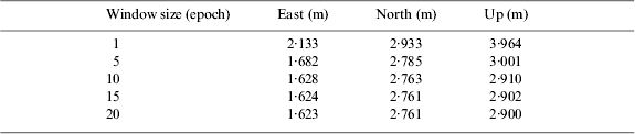
Figure 4 shows the epoch-wise positioning errors of combined GPS/BeiDou SPP based on the three weighting scenarios for the static open-sky test on 8 December 2012. Figure 5 indicates the corresponding number of satellites and PDOP. The results indicate that the positioning errors using three different weighting scenarios are quite consistent. But an examination on the time window that is defined by two vertical dashed lines in Figure 4 demonstrates that the positioning errors using the proposed weighting approach are significantly smaller than using the other two weighting approaches. The largest position errors in the east, north and up directions are −2·086 m, 4·085 m, 11·843 m and −3·966 m, 5·825 m, 8·887 m, respectively, when the first two weighting scenarios are used. By contrast, the largest position errors are −0·854 m, 1·617 m and 4·370 m when the proposed approach is applied, which are considerably smaller. After an examination on the number of visible satellites and PDOP within the time window in Figure 5, it is found that the number of GPS satellites is only six and that is why the new method can improve the positioning accuracy. In this case study, the smoothing window size is set to 10. In order to test the effect of applying different window sizes on positioning accuracy, Table 1 provides the results using the different window sizes of 1, 5, 10, 15 and 20. It is seen that the position accuracy can be improved by only several centimetres when the window size is increased from 5 to 10. When the window size is further increased to 15, the improvement becomes even less significant. This suggests that the window size of 10 is suitable, which will be applied for the rest of our data analysis.
Figure 4. Epoch-wise positioning errors for static test in open sky on 8 December 2012.
Figure 5. Number of satellites and PDOP for static test on 8 December 2012.
Table 1. RMS of positioning errors using the proposed weighting approach with different smoothing window sizes.

Figure 6 further illustrates the weight ratios between GPS and BeiDou measurements for three different weighting scenarios. The weight ratio solutions range from 0·96 to 1·83 for the Helmert approach while the weight ratio estimates vary in a range of 1·38 to 1·77 using the new approach. There are some abnormal small weight ratios at some epochs indicated by the green lines, which are caused by the instability of the Helmert method. The instability is attributable to the failure of convergence due to insufficient redundant observations at these epochs. Compared to the Helmert weighting scenario, the new method is more stable and thus improves the positioning accuracy.
Figure 6. Weight ratios between GPS and BeiDou measurements for static test on 8 December 2012.
To test the effectiveness of the new weighting approach under limited satellite visibility conditions, an experiment was conducted in an area with trees on 24 March 2013, as shown on the right of Figure 1. Figure 7 shows the epoch-wise positioning errors of the combined GPS/BeiDou SPP. The PDOP and number of satellites are provided in Figure 8. The average number of visible GPS and BeiDou satellites are 7·2 and 9·0, respectively, leading to an average PDOP of 1·3 in the combined GPS/BeiDou SPP. When the time window from GPS time of 5:55:30 to 6:53:00 defined by two dashed lines in Figure 7 and Figure 8 was examined, it was found that the new weighting approach improves significantly the positioning accuracy in the case of fewer visible GPS satellites.
Figure 7. Epoch-wise positioning errors for static test under trees on 24 March 2013.
Figure 8. Number of satellites and PDOP for static test on 24 March 2013.
Kinematic experiments were carried out on 24 December 2012 in open sky and under trees, respectively. Figure 9 shows the positioning errors in open sky. During the test period of three hours, an average number of 7·4 GPS and 10·0 BeiDou satellites were available, which results in an average PDOP of 1·1. The positioning results using three different weighting scenarios agree with each other well. The positioning errors with the proposed weighting scenarios are slightly smaller for most of the time than those using the other two weighting scenarios. The degraded quality for the period 4:15∼4:40 is due to the decreased number of visible satellites when the vehicle approached a building. Figure 10 provides the weight ratios between GPS and BeiDou measurements for three different weighting scenarios. The weight ratio solutions are more stable using the new weighting approach than the Helmert method. The hand-held kinematic positioning results under trees are illustrated in Figure 11. It is clear that the new approach shows slightly smaller positioning errors in comparison to the other two weighting methods, especially for the vertical component.
Figure 9. Kinematic positioning errors in open sky on 24 December 2012.
Figure 10. Weight ratios between GPS and BeiDou measurements for the kinematic test in open sky on 24 December 2012.
Figure 11. Hand-held kinematic positioning errors under trees on 24 December 2012.
In order to analyse whether the smoothing window size of 10 used in the new weighting method is suitable for the kinematic test under trees, Table 2 lists the positioning accuracy using different window sizes of 1, 5, 10, 15 and 20. Similar to Table 1, the improvement of the position accuracy is insignificant when the window size is further increased from 10 to 15. This suggests again that the window size of 10 is reasonable.
Table 2. RMS of kinematic positioning errors using the proposed weighting approach with different smoothing window sizes.

To further test the effectiveness of the new weighting method under the tree environment, a car-borne kinematic test was conducted on the campus road towards the west gate of the Central South University, China, on 22 December 2013. The test started at the local time 15:45 (GPS time 7:45) and lasted one and a half hours. The car carried a “Trimble NetR9” receiver with a “TRM55971.00” antenna, which allows concurrent tracking of both GPS and BeiDou signals. The same sampling rate 1 s and elevation mask angle 10° are adopted as those applied in the previous kinematic test. A similar mode of receiver as the rover receiver was set up on the roof of the Mining Building of the Central South University as a base station to help determine the reference coordinates of the rover moving vehicle. The distance between the base and rover stations is less than 1 km. The car was driven back and forth on the road along the same route. The road condition and the setup of equipment are shown in Figure 12.
Figure 12. Car-borne kinematic test under trees on 22 December 2013.
The car-borne kinematic positioning results under trees are depicted in Figure 13. The accuracy improvement in the horizontal directions by the new weighting scenario is clearly seen during the GPS time 7:45∼8:30. The improvement in the vertical direction is especially significant for almost the entire session compared to the results using the Helmert weighting scenario. In this test, the average number of GPS and BeiDou visible satellites are 5·9 and 8·6, respectively, which results in an average PDOP value of 1·4.
Figure 13. Car-borne kinematic positioning errors under trees on 22 December 2013.
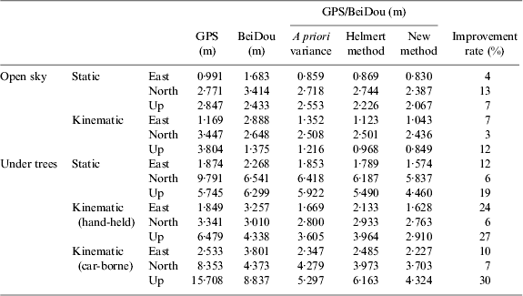
Table 3 summarises the RMS of positioning errors for combined GPS/BeiDou SPP with three different weighting scenarios as well as GPS-only and BeiDou-only SPP for all static and kinematic tests. Comparing to GPS-only or BeiDou-only SPP, the combined use of GPS and BeiDou measurements significantly improves the positioning accuracy in three coordinate components in almost all cases. For all static and kinematic tests, the proposed weighting scenario significantly improves the positioning accuracy when compared to the other two scenarios. The improvement rate with respect to the Helmert method is listed for three coordinate components in the far right column of Table 3 in which the largest improvement rate reaches 30%. Compared to the open sky environment, the improvement under trees is more significant.
Table 3. RMS of positioning errors for GPS-only, BeiDou-only and combined GPS/BeiDou SPP with three different weighting scenarios.
4. CONCLUSIONS
Proper weighting of GPS and BeiDou observations is important in order to achieve the best combined GPS/BeiDou positioning accuracy. Although the Helmert variance component estimation method is widely used for weight determination of different types of measurements, the method requires high redundant observations for each observation group, which cannot often be satisfied for navigation and positioning applications in the field. To solve this issue, a Helmert weighting method with a window-moving average filter is proposed. This approach makes good use of the weight estimates at previous epochs to provide a more precise and reliable weight ratio. Static and kinematic experiments have been carried out in open sky and under tree environments and the results indicate that the new weighting approach significantly improves the positioning accuracy in comparison to the Helmert approach on a single epoch basis. The maximum improvement reaches 30% in the vertical component for the kinematic test under trees. The improvement in the horizontal directions is less significant, mostly at a level of less than 15%. The improvement of combined GPS/BeiDou positioning accuracy has also been assessed with a comparison to GPS-only and BeiDou-only to demonstrate the benefit of the combined use of GPS and BeiDou measurements. Future work includes the application of the proposed weighting approach to GPS/GLONASS, GPS/GALILEO and multi-GNSS combinations.
ACKNOWLEDGEMENTS
The financial supports from National Natural Science Foundation of China (No: 41004011), National Basic Research Program of China (No.2013CB733303) and China Postdoctoral Science Foundation (No. 2014M550425) are greatly appreciated. The contribution of precise products from IGS is also appreciated.