


The emergence of social complexity during the Bonito Phase (ca. AD 850–1150) in Chaco Canyon, New Mexico (Figure 1), attested to by massive construction projects and possible hierarchical social structure, was supported by agricultural production—primarily maize (Zea mays) but also squash (Cucurbita pepo), beans (Phaseolus vulgaris), and a wide range of nondomesticates that were likely cultivated or encouraged in field areas (Mathien Reference Mathien2005; Toll Reference Toll and Lekson2006; Toll et al. Reference Toll, Toll, Newren, Gillespie and Mathien1985; Windes Reference Windes2015). However, the exact nature of agricultural strategies in Chaco during this time remains difficult to define. The location of agricultural fields within the canyon has been an especially vexing question.
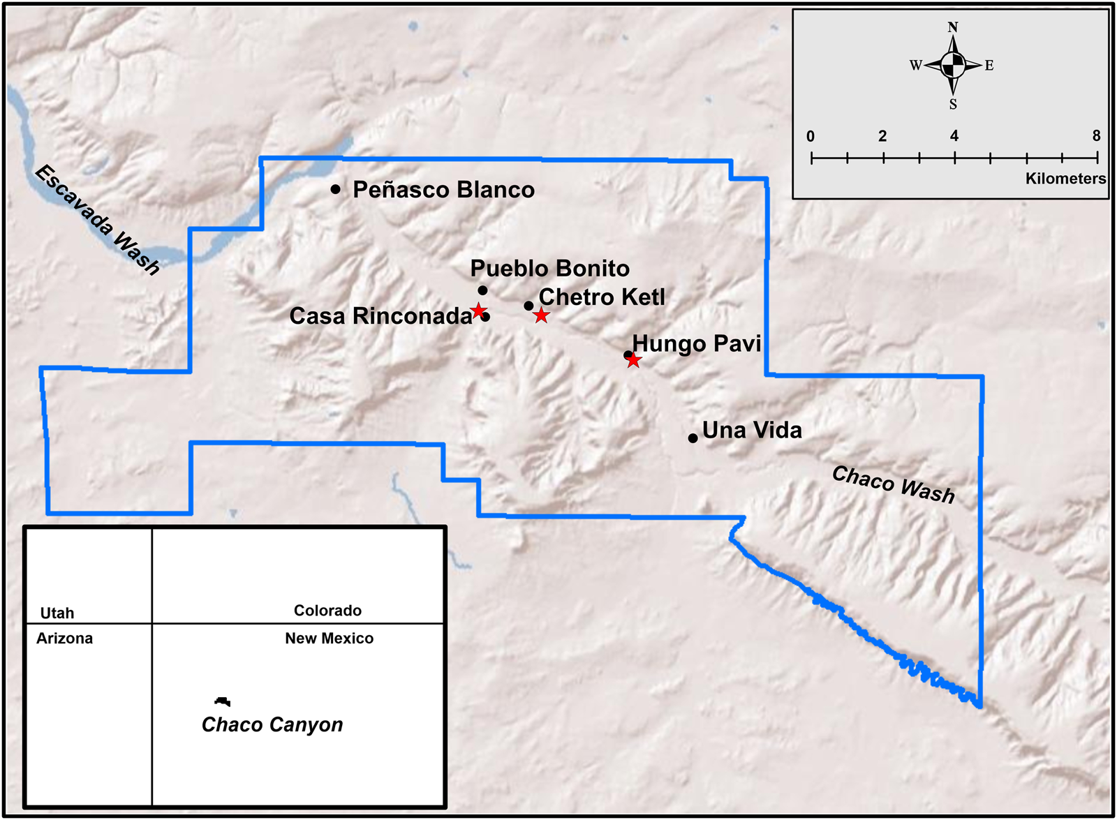
Figure 1. Chaco Canyon, New Mexico, showing the current boundaries of Chaco Culture National Historical Park. Major great-house sites within the canyon are noted, with stars representing the three study areas presented in this article. (Color online)
R. Gwinn Vivian (Reference Vivian and Longacre1970, Reference Vivian, Downing and Gibson1974, Reference Vivian1990:310, Reference Vivian and Doyel1992:51; Vivian and Watson Reference Vivian, Watson, Heitman and Plog2015; Vivian et al. Reference Vivian, Van West, Dean, Akins, Toll, Windes and Lekson2006:50) recognized that Chaco farmers probably employed different types of agricultural fields according to local conditions but believed that the development of large gridded fields with associated irrigation ditches was critical to the evolution of social inequality during the Bonito Phase. In Vivian's formulation, the construction and management of extensive formal field systems required the ability to coordinate large numbers of workers during brief but intensive periods of summer thunderstorms in order to allocate water effectively. Gridded fields were assumed to have been owned and controlled by great-house residents, especially on the north side of the canyon, and great-house leaders used surpluses from these field systems to underwrite nascent social differentiation between communities (Figure 2).

Figure 2. Schematic drawing of a gridded field system in Chaco, which is based on observable grid patterns near the Chetro Ketl great house. This field pattern is hypothesized to exist throughout the canyon floor, particularly on the north side, encompassing an area of approximately 900 acres of valley floor. (Images adapted from Vivian Reference Vivian1990:Figure 8.38 and Vivian et al. Reference Vivian, Van West, Dean, Akins, Toll, Windes and Lekson2006:Figure 2.2.)
Gridded fields are common features in the agricultural economies of many historical societies in the American Southwest, typically featuring large areas subdivided into smaller plots to facilitate water distribution and crop growth (Dominguez Reference Dominguez2002; Maxwell and Anschuetz Reference Maxwell, Anschuetz and Killion1992). In southern Arizona, gridded fields occur along the floodplains of major rivers by 1000 BC, and there is no doubt that, for millennia, farmers in this region intensified agricultural production through the diversion of water in carefully maintained arrays of fields (Berlin et al. Reference Berlin, Salas and Geib1990; Fish and Fish Reference Fish and Fish1992; Schaafsma and Briggs Reference Schaafsma and Briggs2007). In contrast, gridded field systems are rare in the archaeological record of the northern U.S. Southwest and especially the Colorado Plateau. In Chaco Canyon, the only clearly visible example of a gridded feature (Figure 3) is found southeast of the Chetro Ketl great house (Loose and Lyons Reference Loose, Lyons and Lyons1976a; Love Reference Love1980; Sturm Reference Sturm2016; Wills Reference Wills2017). Models that show gridded fields throughout Chaco Canyon (e.g., Vivian et al. Reference Vivian, Van West, Dean, Akins, Toll, Windes and Lekson2006) rely on features such as masonry headgates and associated ditches as proxies for fields rather than physical evidence for the presence of agricultural plots.
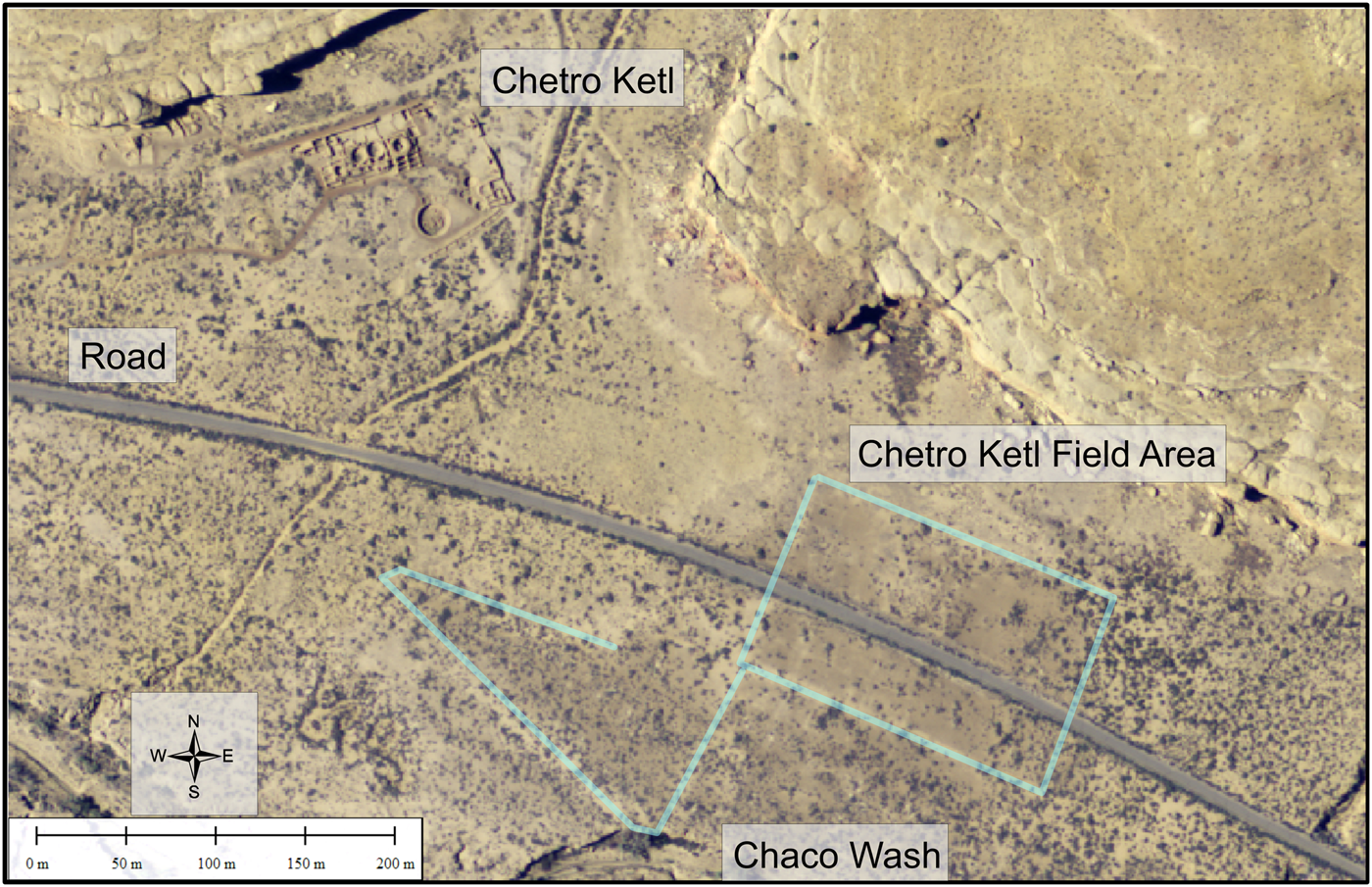
Figure 3. Orthophoto from the Chetro Ketl great-house area. The Chetro Ketl field area, southeast of Chetro Ketl, is highlighted. Faint interior lines that constitute a grid pattern are visible within the overall rectangular area. (Color online)
Since no areas in Chaco other than the floodplain southeast of Chetro Ketl exhibit visible grid patterns, it makes sense to ask whether geophysical remote sensing, including ground-penetrating radar (GPR) and magnetometry, might locate buried features in areas of predicted gridded fields that conform to an array of field plots separated by irrigation ditches. In fact, researchers at the National Park Service's (NPS) newly formed Division of Remote Sensing first asked this question in the 1970s. Created to assess the effectiveness of various remote-sensing techniques for American archaeology, the Division of Remote Sensing systematically conducted some of the earliest remote-sensing experiments in Chaco Canyon (Aikens Reference Aikens1980; Avery and Lyons Reference Avery and Lyons1978, Reference Avery and Lyons1981; Baker and Gumerman Reference Baker and Gumerman1981; Camilli and Cordell Reference Camilli and Cordell1983; Drager and Lyons Reference Drager and Lyons1985; Ebert and Hitchcock Reference Ebert, Hitchcock and Reher1977; Loose and Lyons Reference Loose, Lyons and Lyons1976b; Lyons and Avery Reference Lyons and Avery1977; Lyons et al. Reference Lyons and Mathien1980; Morain et al. Reference Morain, Budge and Lyons1978, Reference Morain, Budge and Komarek1981; Potter and Kelley Reference Potter, Kelley, Lyons and Mathien1980; Wood et al. Reference Wood, Nickel and Griffin1984). Many of these efforts included the Chetro Ketl field area, involving some of the first applications of GPR and magnetometry in American archaeology (Loose and Lyons Reference Loose, Lyons and Lyons1976a; Lyons et al. Reference Lyons, Hitchcock, Pouls and Lyons1976; Vickers and Dolphin Reference Vickers and Dolphin1975; Vickers et al. Reference Vickers, Dolphin, Johnson and Lyons1976). Unfortunately, these pioneering efforts lacked the technological and computing power necessary to identify any subsurface features corresponding to the visible grids (Ebert and Lyons Reference Ebert, Lyons and Lyons1976; Lyons Reference Lyons1977; Lyons and Mathien Reference Lyons, Hitchcock and Wills1980).
Archaeologists today routinely employ a range of nondestructive remote-sensing techniques that have realized the original NPS Division of Remote Sensing goals of mapping complex and spatially expansive sites prior to expensive excavations (e.g., Burks and Cook Reference Burks and Cook2011; Herrmann et al. Reference Herrmann, King and Buikstra2014; Thompson Reference Thompson2014). In this study, we offer a contribution to another of the Division of Remote Sensing's major objectives—using nondestructive remote sensing to evaluate specific hypotheses derived from prior archaeological research.
Methods
We selected three study areas previously identified as locations of gridded field systems: the Chetro Ketl complex, the area northwest of Casa Rinconada, and the area southeast of the Hungo Pavi great house (see Figure 1). GPR was the primary geophysical method used, with magnetometry applied selectively as a comparative method. All GPR data were collected using a GSSI SIR-3000 data controller with 400 MHz and 270 MHz antennas. Data were collected in rectilinear grids and individual transects in select locations of each study area that had been staked out with a real-time kinematic global navigation satellite system (RTK GNSS) to maintain sub-centimeter-level spatial control. Data in grids were collected using 50 cm transect spacing and a sampling rate of 40 reflection traces per meter. The time window within which reflections were recorded ranged from 40 to 50 nanoseconds (ns), filtered between 135 MHz and 800 MHz depending on the antenna frequency being used. The data were processed to generate both reflection profiles and amplitude slice-maps using the programs GPRViewer+ and GPR-SLICE. To convert time measurements to depth, a velocity analysis was performed (Conyers Reference Conyers2013). This resulted in an average relative dielectric permittivity (RDP) ranging from 8.4 to 5.2, or approximately 10–13 cm/ns in two-way travel time.
Magnetometry was used as a secondary geophysical method in areas previously collected with GPR. The magnetic data were collected using a Bartington Grad601 fluxgate gradiometer, with transects collected using a 50 cm spacing and eight samples per meter. The data were processed to generate magnetic gradient maps using the program Terrasurveyor.
The geophysical survey grids were placed throughout the selected study areas to evaluate as much area as possible while also avoiding surface obstacles such as heavy vegetation, which could not be removed within the national park. In all three study areas, additional grids were collected after the initial results from the surveys had been obtained. This iterative approach not only allowed us to adjust our collection strategy based on each survey's results but also generated a wealth of knowledge about the geophysical data collected during different seasons and over multiple years. The total surface area surveyed ranged from approximately 5,250 m2 to 8,875 m2 per study area.
All geophysical data were integrated into a GIS database to maintain spatial control over the survey areas and analyze the data in relation to the broader landscape. Because the majority of patterns being mapped are linear in nature, maintaining a high level of spatial control was critical for analyzing the layout and orientation of those features. Historic aerial photos housed at the University of New Mexico (UNM) and NPS Chaco Archives were utilized to assess land modifications from the historic period and aid in interpretations. Further information regarding data collection and processing procedures can be found in Sturm (Reference Sturm2016).
The Study Areas and Survey Results
Chetro Ketl Field Area
The Chetro Ketl field area, first photographed from the air by Charles Lindberg in 1929, is defined by a large, rectangular area with noticeably different soil and vegetation properties than the land surrounding it. A number of highly uniform grids are faintly apparent in modern aerial imagery (see Figure 3). In addition to its notable grid pattern, several other visible features are often interpreted as part of the overall field system. These include long, narrow features that form a triangular shape west from the field area to the nearby Chaco Wash (Figure 3). The function of these features has been the subject of speculation, although they are most commonly explained as large earthen berms (Loose and Lyons Reference Loose, Lyons and Lyons1976a; Stein et al. Reference Stein, Friedman, Blackhorse, Loose and Lekson2007:210). Other features considered standard components of a field system, such as headgates, are hypothesized to exist in relation to the field area, but they have not been definitively located.
Geophysical remote sensing by UNM researchers began in 2014, and initial results were reported by Sturm (Reference Sturm2016). A total of 19 GPR grids, 19 GPR transects, and two magnetometry grids have been collected in this area (Figure 4). The first results from the GPR surveys showed a complex series of buried linear and circular features below the grid pattern visible on the ground surface. The overall layout of this buried pattern includes long linear features that are oriented northwest-southeast (approximately 45 degrees from the orientation of the surface pattern) with shorter linear features that intersect the others at varying angles (Figure 4). The overall pattern has some elements of a grid pattern but with far less uniformity than seen in the surface pattern. Most of the newly identified linear features are approximately 50 cm wide. Based on records from excavations conducted in this field area in the 1970s, it is likely that these buried linear features are small earthen berms (Loose and Lyons Reference Loose, Lyons and Lyons1976a; Sturm Reference Sturm2016). In addition to these earthen berms, numerous circular features were identified in the GPR maps (Figure 4). These range in size from about 2 to 5 m, and extend no deeper than about 90 cm. Each exhibits a slight concavity in the reflection profiles, which gives them a basin-like appearance, although their function is unknown. In the magnetometry data, a number of very shallow linear features were mapped that show a similar orientation to the surface grid pattern but that are not visible at the surface. Some of these very shallow linear features are also identifiable in the GPR (Figure 4). It may be that both the GPR and magnetic data are capturing transitional building episodes that culminated in the final grid pattern visible on the surface.
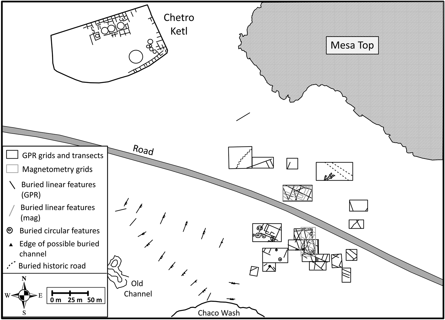
Figure 4. The Chetro Ketl field study area, showing locations of the geophysical data collected as well as the interpretations made from the geophysical data analysis. The depths of features identified range from the ground surface to approximately 90 cm.
In addition to the geophysical grids collected within the main field area, 18 GPR transects were collected over the triangular area in order to determine whether these long linear features were earthen berms. Fifteen of the GPR transects show evidence of three distinct linear features, possibly channels, the edges of which are visible as slight hyperbolic reflections with sloping concave-shaped reflections in between (Conyers Reference Conyers2012; Goodman and Piro Reference Goodman and Piro2013). These possible channels consistently measure approximately 3 m in width and approximately 80 cm in overall depth (Figure 5).

Figure 5. Reflection profiles collected in the triangular area of the Chetro Ketl field area showing the reflections from possible buried channels throughout this area. These possible channels are visible in the reflection profiles from both the 400 MHz antenna (top) and 270 MHz antenna (bottom) and consistently measure approximately 3 m across and extend approximately 80 cm below the ground surface.
One GPR transect was collected over a hypothesized channel just north of the grid area that might have been the main channel diverting water from the mesa top onto the field area, according to reconstructions by Vivian (Reference Vivian1990) and others (Loose and Lyons Reference Loose, Lyons and Lyons1976a). This transect was inconclusive in confirming a channel, but it is possible that a nearby historic road has obscured it, if it existed (see Figure 4). The edges of other possible small channels, however, were mapped in the northeasternmost grid, but again, a nearby historic road has likely destroyed any additional sections of these possible channels. Another historic road is visible in the northwesternmost grid (Figure 4), and several trenches excavated in this area by the NPS during the 1970s have been georeferenced and accounted for in the interpretations for this area (Supplemental Figure 1).
In sum, the Chetro Ketl field area is the most complex of the three study areas and exhibits both lateral extensiveness and evidence of substantial remodeling (Figure 4). It is also clear that we have not mapped its full extent. Additional future geophysical mapping should help further define this extensive complex.
Casa Rinconada Complex
The landscape northwest of Casa Rinconada is one of the few areas on the south side of the canyon that is explicitly described and drawn as having a gridded agricultural field system (Loose and Lyons Reference Loose, Lyons and Lyons1976a; Vivian Reference Vivian, Downing and Gibson1974). A small section of this gridded field area is shown on unpublished field maps (Vivian Reference Vivian1980). This gridded field, however, has not been confirmed through testing, and it is not visible on the ground surface today. Furthermore, it has not been relocated or remapped since it was first recorded by Vivian. Vivian (Reference Vivian1990:313; Reference Vivian and Lekson2000:6) also described the area as having a canal irrigation system, and he excavated several headgates in the area that had been remodeled while in use. Several excavated headgates are exposed on the surface, but no canals are visible.
Nine GPR grids, six GPR transects, and one magnetic grid were collected in the Casa Rinconada area (Figure 6). Several of the northernmost grids showed no evidence of archaeological features or only revealed features related to historic activity, including historic roads. This area was heavily utilized in the twentieth century, and it is likely that such activity has obscured or destroyed some land use features related to earlier Bonito Phase occupation. Multiple features, however, were identified in the southernmost geophysical grids and transects (closest to the landform on which Casa Rinconada sits), and these have been interpreted as possible features of archaeological interest.

Figure 6. The Casa Rinconada study area showing the locations of all geophysical data collected as well as the features identified from the geophysical surveys. A possible channel appears to run the length of the survey areas. The depths of the identified features range from the surface to approximately 85 cm. GPR grids A–C are shown in Figure 7.

Figure 7. GPR amplitude slice-maps from Grids A, B, and C. These show the reflections from numerous features, including the edges of possible buried channels, linear features, circular features, and a possible architectural feature. Also noted are the locations of headgates visible on the ground surface. These slice-maps represent a depth of approximately 20–35 cm. (Color online)
High-amplitude linear reflections in the GPR slice-maps represent possible edges of buried channels (Figure 7; Supplemental Figure 2). Additionally, a number of lower-amplitude linear features and circular features were mapped with GPR, particularly in Grids A–C (Figure 7). The differences in amplitude strength in this area are likely associated with different materials or phenomena (Conyers Reference Conyers2013; Goodman and Piro Reference Goodman and Piro2013). The lower-amplitude linear and circular features may have a higher clay content (thus attenuating the radar energy more quickly) or may be less substantially built and generating less physical contrast than other nearby channel and masonry features (Conyers Reference Conyers2012). The linear features measure approximately 50 cm in width (Supplemental Figure 3), and the circular features average between 2 and 4 m in diameter. These measurements are similar to the linear and circular features mapped in the Chetro Ketl field area as well. The possible buried channels are also visible in the reflection profiles as a set of concave reflections that match the location of the high-amplitude reflections seen in the slice-maps (Conyers Reference Conyers2012, Supplemental Figure 2). The edges of channels were identified in four of the GPR grids and in all six GPR transects. At least two separate possible channels were mapped in the westernmost grid, although it is unclear if the channels mapped in the other grids and transects represent the same main channel or multiple channels. It seems likely that these possible channels are associated with the excavated headgates. A possible channel identified in Grid D seems to divert directly into a headgate (Figure 6), which is evident both on the surface and in the GPR slice-maps (Supplemental Figure 2). A buried feature in Grid C, seen as a concentration of high-amplitude reflections in the amplitude slice-maps and associated with a buried channel, may be another masonry headgate (Figure 7; Supplemental Figure 3).
Two primary features in the magnetic data were mapped at shallower depths than the features identified with GPR (Figure 6), but given their very shallow depth, these may represent historic impact of the ground surface.
Hungo Pavi
The Hungo Pavi great house is located at the confluence of the northern main canyon floor and Mockingbird Canyon. Various economic models and maps suggest that a gridded field system should be located to the southeast on the tributary outwash fan (Sebastian Reference Sebastian1992a, Reference Sebastian and Doyel1992b; Vivian and Watson Reference Vivian, Watson, Heitman and Plog2015; Vivian et al. Reference Vivian, Van West, Dean, Akins, Toll, Windes and Lekson2006:50). Twelve GPR grids and two magnetic grids were collected in this area, which is divided by a park road (Figure 8). While most of the grids did not show evidence of features of archaeological interest, several possible architectural and linear features were identified in several grids (Figure 8).

Figure 8. The Hungo Pavi study area, showing the locations of all geophysical grids collected as well as the features identified from the geophysical data analysis. The depths of the interpreted features range from the ground surface to approximately 75 cm. No features of archaeological interest were identified in the grids north of the park road. (Color online)
In the GPR data, two clear concentrations of high-amplitude reflections indicate possible architectural features (Supplemental Figure 4). The distinct hyperbolic point source reflections commonly associated with walls are visible in the reflection profiles at a depth of about 40 cm and spaced approximately 6 m apart (Conyers Reference Conyers2012; Sunseri and Byram Reference Sunseri and Byram2017). A planar reflection in between these hyperbolic reflections may relate to a floor surface (Supplemental Figure 4). Linear features were also identified in the GPR slice-maps and are visible in the magnetic data with a low magnetic intensity, indicating only subtle physical differences from the surrounding sediments (Kvamme Reference Kvamme and Johnson2006; Figure 9). These linear features show some similarities to a grid pattern (see Figure 8) but with far less uniformity than the surface pattern seen in the Chetro Ketl field area. The full extent of these linear features has not been ascertained, but it is possible that only a small portion was mapped and that features extend to the south and west (Figure 8). There are also no indications of potential remodeling or realignment as is found at Chetro Ketl, and none of the architectural features identified in the GPR data are superimposed on these linear features, which suggests that they may be associated and/or contemporaneous.

Figure 9. Magnetic gradient maps from the Hungo Pavi study area showing subtle linear features that appear to form part of a grid pattern.
Discussion
Test excavations by the NPS in 1974 in the Chetro Ketl field complex were instrumental to our comparative study of possible field areas at Casa Rinconada and Hugo Pavi. Profile drawings from the NPS backhoe trenches recorded buried earthen berms (Loose and Lyons Reference Loose, Lyons and Lyons1976a:141; Supplemental Figure 5), and the description of these features helped us interpret many of the buried linear features identified in the GPR maps as earthen berms. In addition, GPR profiles collected over small channels currently visible in the sides of the Chaco Wash allowed us to develop expectations for how channels would appear in other GPR profiles, consistently seen in the reflection profiles as sets of sloping concave reflections (see Figure 5; Conyers Reference Conyers2012, Reference Conyers2013; Sunseri and Byram Reference Sunseri and Byram2017).
The widths of the linear features (earthen berms) identified at all three areas are similar at about 50 cm, and all three areas have linear features that form at least partial sections of what can be described as a grid pattern (Figure 10). The depths of the linear features identified at all three study areas are similarly shallow, most occurring within the first 50 cm of subsurface. In addition, all three areas show evidence of other possible features among the linear features. At Chetro Ketl and Casa Rinconada, these are evident as numerous buried circular features. These circular features are consistently 2–5 m in width, and they extend to a maximum depth of about 90 cm. The nature of these buried circular features is unknown, but their reflectivity, distinct edges, and slight concave appearance in the GPR data suggest that they may be pits (Conyers Reference Conyers2012). Pit features have been recorded in archaeological agricultural field systems in the American Southwest, and they are often interpreted as borrow pits for constructing the grid berms or small reservoirs for storing water (Dominguez Reference Dominguez2002; Maxwell and Anschuetz Reference Maxwell, Anschuetz and Killion1992; Wills et al. Reference Wills, Baker, Baker, Duran and Kirkpatrick1990). However, buried archaeological sites and features are common in this part of the canyon, and subsurface testing will be needed to determine the nature of the features identified in the GPR data.

Figure 10. The main land-use patterns identified with geophysics at the three study areas, with the surface grid pattern at the Chetro Ketl field area for comparison. None of the newly identified buried patterns shows the same remarkable uniformity as the surface pattern near Chetro Ketl.
At Chetro Ketl and Hungo Pavi, there are features that appear to be single-room or other small structures on the surface, and several more were identified in the GPR data. Historical structures occur on the surface throughout this part of the floodplain, and currently, there is no way to date these features or assess any possible association with other buried features. Finally, evidence of multiple possible buried channels is present at Chetro Ketl and Casa Rinconada. At Chetro Ketl, these channels appear to be on the edges of the main linear pattern, while at Casa Rinconada, at least one main channel appears to run through the primary pattern where the headgates are located. No likely channels were identified at Hungo Pavi.
None of the newly identified patterns show the same remarkable uniformity and layout visible at the surface of the Chetro Ketl complex (Figure 10), with its well-defined series of surface grids that each measures approximately 22.5 m × 13.5 m (Loose and Lyons Reference Loose, Lyons and Lyons1976a; Vivian and Watson Reference Vivian, Watson, Heitman and Plog2015), although the geophysical remote-sensing data does reveal some buried features that express roughly grid-like patterns in some limited areas. And although we recognize that headgates and small man-made ditches were built for water control during the Bonito Phase, there is no indication in the geophysical remote-sensing data that these features were part of large formal fields or that the floor of the canyon along the margins near great houses was heavily farmed by constructing extensive arrays of irrigated rectangular plots.
Implications
These geophysical analyses and results represent one aspect of a larger research program at Chaco Canyon undertaken by the University of New Mexico to investigate socioeconomic change during the Bonito Phase (Drake et al. Reference Drake, Wills, Hamilton and Dorshow2014; Wills and Dorshow Reference Wills and Dorshow2012; Wills et al. Reference Wills, Scott Worman, Dorshow and Richards-Rissetto2012, Reference Wills, Love, Smith, Adams, Palacios-Fest, Dorshow, Murphy, Sturm, Mattson and Crown2016). Much of this research has been about the interdependent roles of water and food production in the development of Chacoan society. Although agricultural production has been a focus of research in Chaco since the 1920s, Mills (Reference Mills2002) noted that explanatory models have been predicated on a remarkably limited amount of empirical evidence for the nature of farming. Our research program is designed to generate relevant data about food production from new fieldwork. We have been surprised, given the deep interest in these issues, that no conclusive Bonito Phase agricultural field or field system has yet been discovered in Chaco, and that there are only 18 known headgates that might be indicators of cultivated areas (or small reservoirs)—all of which are small enough to have been built and operated by a family (Sebastian Reference Sebastian1992a:56; Wills Reference Wills2017). Moreover, excavations of headgates in the 1970s produced associated ceramics that date to the AD 1100s, after the peak of great-house construction, which postdate most of the development of great-house society (Force et al. Reference Force, Gwinn Vivian, Windes and Dean2002; Wills Reference Wills2017).
The Chetro Ketl grid pattern visible at the surface today is clearly analogous in configuration to historical field systems among Pueblo, Navajo, and Hispanic farmers, including a modern Navajo field complex located approximately 16 km away (Wills Reference Wills2017:376). It is also the case that the Chetro Ketl grid array is located at the upstream end of a massive earthen horseshoe-shaped dam and reservoir built in the early twentieth century. Consequently, it may have been associated with the approximately 200 acres under cultivation by the Wetherill Trading Post at that time. Several researchers have even questioned any agricultural function for the Chetro Ketl grids. Their alternative suggestions include a ground plan for an unbuilt great house (Stein and Fowler Reference Stein, Fowler and Adler1996:120), frog ponds (Love Reference Love1980:345), or ceremonial performance areas (Stein et al. Reference Stein, Friedman, Blackhorse, Loose and Lekson2007:210). This ambiguity about when the Chetro Ketl pattern was produced and what it represents is why nondestructive remote sensing is a valuable approach to evaluating how well the gridded agricultural field model predicts the location and stratigraphic context of similar features in other parts of the canyon.
In our investigation, all three study areas have subsurface features but none conforms to the highly formalized large gridded pattern at Chetro Ketl. Based on these data, we can hypothesize that Chaco farming was largely based on methods that did not leave much physical evidence. To the extent that Chaco farmers might have utilized formal gridded fields for agricultural production, such features may have been a relatively small part of the overall farming economy, as originally argued by Loose and Lyons (Reference Loose, Lyons and Lyons1976a), rather than the primary mode as proposed by Vivian and colleagues (Reference Vivian, Van West, Dean, Akins, Toll, Windes and Lekson2006). Historical Pueblo groups with extensive irrigated field systems much larger than the gridded area at Chetro Ketl practiced field cultivation at the household level (Ford Reference Ford and Ortiz1972; Levy Reference Levy1992), so the elusiveness of such systems at Chaco is consistent with a reliance on relatively ephemeral plots managed by small kin groups as the main local source of agricultural production (Wills Reference Wills2017; Wills and Dorshow Reference Wills and Dorshow2012).
We are not arguing that farming areas in Chaco during the Bonito Phase were too limited to have been a significant part of the canyon economy, as some researchers have recently done (Benson and Grimstead Reference Benson and Grimstead2019). Maize and squash pollen are common in both the alluvium and residential contexts, and there is no question that crops were grown throughout the canyon and adjacent mesa tops (Hall Reference Hall1977, Reference Hall1988, Reference Hall, Fassett, Zeigler and Lueth2010; Mathien Reference Mathien2005; Toll et al. Reference Toll, Toll, Newren, Gillespie and Mathien1985). Moreover, local potential agricultural productivity was much higher than is often assumed if areas other than the active floodplain are included in such measurements (Dorshow Reference Dorshow2012). Rather, our analyses suggest that extensive formal gridded field systems were probably not as important to the Chaco economy as less costly and more flexible cultivation tactics were, such as dispersed plantings and seasonal ditching on outwash fans.
The next step in our research program is to utilize the high-resolution geophysical and geospatial evidence to conduct test excavations to determine the nature of these complex buried features. We have been able to identify the complex buried land patterns along the canyon floor only by collecting geophysical data multiple times per field session, in different conditions and seasons, and over multiple years. It is unlikely that a single survey—or even a single field season—would have allowed us to generate such a robust database from which to make these interpretations. The NPS Division of Remote Sensing anticipated that the evolution of remote-sensing technology would one day give archaeologists a powerful tool for accessing complex subsurface archaeological records. It seems fitting that the fruition of those technologies has allowed us to generate new insights about a long-standing debate in Chaco archaeology.
Supplemental Materials
For supplementary material accompanying this paper, visit https://doi.org/10.1017/aaq.2019.98.
Supplemental Figure 1. Georeferenced locations of the 1970s trenches excavated in the Chetro Ketl Field Area.
Supplemental Figure 2. GPR amplitude slice-map (top) from Grid D in the Casa Rinconada study area showing the reflections from a possible buried channel leading into a partially buried headgate that extends to the surface.
Supplemental Figure 3. Reflection profiles collected with a 400 MHz antenna in the Casa Rinconada study area.
Supplemental Figure 4. GPR amplitude slice-map from the Hungo Pavi study area showing the high-amplitude reflections from possible buried architectural features.
Supplemental Figure 5. An earthen berm identified in the Chetro Ketl field area.
Acknowledgments
This research was conducted under NPS permit # CHCU 16-01 and as part of a cooperative agreement between Chaco Culture National Historical Park (CCNHP) and the University of New Mexico. This work was funded by a National Science Foundation Doctoral Dissertation Improvement Grant (Award #1649264). Our sincerest thanks go to the personnel at CCNHP, especially Dabney Ford (ret.), Roger Moore (ret.), Wendy Bustard, Aron Adams, and Hilary Grabowska. We gratefully acknowledge colleagues who have helped with various aspects of this work, including Chet Walker and Scott Gunn. Several anonymous reviewers provided helpful insights on earlier drafts of this article. We are also pleased to recognize the original staff of the Division of Remote Sensing—especially Tom Lyons, Richard Loose, Dwight Drager, Gretchen Obernauf, Jim Ebert, Bob Hitchcock, and Dedi Snow—whose pioneering work made ours possible. And finally, enormous thanks to R. Gwinn Vivian for his generosity and insights.
Data Availability Statement
All geophysical data (as processed and presented) and associated records are available at Chaco Culture's National Historical Park (CCNHP) Museum Collection. The museum collection is open 9:00 a.m.–4:00 p.m. Monday–Friday by appointment only. Researchers interested in accessing the collections should submit a formal research request detailing their research project. Research requests may be mailed, faxed, or e-mailed to:
NPS Chaco Museum Collection
Hibben Center, Room 307
450 University Boulevard NE
Albuquerque, NM 87106
Fax: 505-346-2523
Email: CHCU_Curation@nps.gov


