Professor Barry Cunliffe's 20-year programme of excavation at Danebury, Hampshire, is one of the most comprehensive investigations of an Iron Age settlement ever undertaken in the British Isles and has established this hillfort as a key type-site for our understanding of the period. This is perhaps surprising given that Danebury is a relatively unremarkable hillfort in Wessex and certainly not one of the largest, even in Hampshire. In part, the impact of Cunliffe's Danebury excavations has been similar to that of Bersu's Little Woodbury (Reference Bersu1940) by successfully making an intensively occupied, but otherwise atypical, settlement into one of the best-known Iron Age sites in Britain. This has certainly been a result of the quality of those excavations, but more importantly, the presentation of the data to both a professional and public audience. Whereas Bersu's Little Woodbury became synonymous with the typicality of Iron Age farmsteads in southern Britain (Hawkes & Piggott Reference Hawkes and Piggott1948; Hawkes and Hawkes Reference Hawkes and Hawkes1948), Danebury has been established as typical of the Iron Age hillforts, particularly in the popular literature (see especially Pryor Reference Pryor2004; Reference Pryor2005; James Reference James2005; Dyer Reference Dyer2003; Cunliffe Reference Cunliffe2003).
Yet Danebury is not a typical Iron Age hillfort, even in Hampshire. Whereas many other hillforts in the county such as St Catharine's Hill and Bury Hill were periodically abandoned and reoccupied (Hawkes et al. Reference Hawkes, Myers and Stevens1930; Cunliffe & Poole Reference Cunliffe and Poole2000a), Danebury appears to have been occupied throughout the Early and Middle Iron Age. Even so, there are interesting continuities and discontinuities of use suggested by the excavated detail, and subtle differences of interrupted sequences of activity. These are likely to indicate the establishment and reproduction of various senses of community and identity among the people who used and visited Danebury.
The aim of this paper is to re-assess the Danebury structural assemblage in order to question why Iron Age people came together in this place, and how those that did come perceived their place within wider group identities. Danebury is not a type-site and the need to consider the hillfort settlement in relation to the surrounding landscape and as part of a network of complex relationships between Iron Age groups will be stressed. Initially the structural sequence and chronology as suggested by the excavator (Cunliffe Reference Cunliffe1984; Reference Cunliffe1995) will be reviewed, followed by a (re)examinination of sequences of activity within the hillfort to question how Iron Age people went about building and maintaining a hillfort community. In particular the paper will examine what is meant by the term ‘a hillfort community’ and how this may change over time. It will be argued that the working and reworking of ditches and ramparts may have been of particular importance as a means of community action, which came to represent the group itself. Finally, it will be suggested that the biographies of households became intertwined with Danebury hill. Building ramparts, cleaning out ditches, storing grain, and feasting were all mechanisms for families or groups to create a sense of place and reproduce a sense of community.
Cunliffe's Danebury
For this discussion it is important to outline the key aspects of Cunliffe's (1984) interpretation of Danebury and other hillforts. In particular, the following will focus upon Cunliffe's development of a chronological model and his interpretation of spatial patterns of activity and occupation.
Chronology
The Danebury chronological model is based on the validity of the relationship between the structural sequence and the pottery typology. Cunliffe (Reference Cunliffe1984) identified a series of well-stratified deposits preserved immediately behind the ramparts. These sequences could be divided into quite narrow time bands which, he argued, corresponded to the refurbishments of the ramparts (1995, 16). Associated pottery enabled archaeological features to be assigned a phase within the sequence. However, most of the interior of the hillfort had been subject to significant erosion and the deeply stratified layers were restricted to areas in the lee of the ramparts. As a consequence, an overall stratigraphic phasing of the interior was not possible, although the quarry hollows provided useful local sequences which could be cross-compared. The ceramic phases correlated with the main stages of the development of the defensive sequence, although the problem here is that one has to question whether the construction events were one-offs, or were the culmination of many years work.
Cunliffe's (1984; 1995) model recognised nine ceramic phases (cps 1–9) spanning the latter half of the 1st millennium bc in Hampshire. These ceramic phases were used to help define the different ‘periods’ of activity within the hillfort, which were numbered 1–8 (with many sub-periods), and related to the observed stratigraphic sequence. Radiocarbon dating was used to provide broad date brackets for the ceramic phases. Seventy radiocarbon samples were taken which represented, at the time, one of the largest programmes of sampling on any site in Britain. Samples were selected from well-sealed deposits related to either a distinctive ceramic assemblage or clearly defined structural phase. This allowed for the dating of the ceramic phases although it was clear that there was considerable overlap between the dates from each phase (see Cunliffe & Orton Reference Cunliffe and Orton1984, fig. 5.1). A statistical test (the k sample generalisation of the Wilcoxon-Mann-Whitney test) was carried out which they claimed showed that the distribution of dates in each phase differed significantly from those in other phases and thus the postulated order of the ceramic phases was correct (ibid., 193–4). Despite this the original analysis of the Danebury radiocarbon dates had two serious flaws; it was based on uncalibrated dates and it was unable to give interval estimates of the various phases (Orton Reference Orton1995). With the establishment of reliable calibration curves and the introduction of Bayesian statistical analysis, by the time of the publication of the sixth and final volume of the Danebury excavations (Cunliffe Reference Cunliffe1995) the chronology had changed significantly (Table 1). The overall effect was to suggest a later beginning for the hillfort and drastically shortening cp 4–5 and cp 6. A generalised correlation of site chronology as it is currently understood is presented in Table 2.
Table 1 The danebury chronology as it was understood in 1984 and 1995

Based on Cunliffe (Reference Cunliffe1984, table 23) and (1995, table 3)
Table 2 Chronology of danebury as currently understood showing relationship between period and ceramic phase

Based on Cunliffe (Reference Cunliffe1995, table 3)
The development of the hillfort
Spatial patterns of activity and occupation were set against this chronological sequence (Fig. 1). The outer earthwork was argued to have been part of a major phase of land division in the 8th or 7th centuries bc, which involved the construction of the Danebury Linear. Cunliffe (Reference Cunliffe1995, 19) suggested a simple functional explanation of the early enclosure, perhaps for corralling livestock that had been driven along the Linear. The early univallate hillfort was built wholly within the territory defined by the hilltop enclosure, with two entrances, one in the east and the other in the south-west. At a later stage, foreworks were added at the south-west entrance and rampart 2 was constructed. Finally, the south-west gate was blocked, the inner earthwork was heightened, and the east gate became the focus for elaborate earthworks. The ramparts were subject to periodic modification, but sections excavated through the ditch fills showed more regular cleaning out (Cunliffe Reference Cunliffe1991, 577). Cunliffe also investigated the counterscarp in section, which showed a series of tips of material (1995, 23). The implication is that major rampart construction was episodic, but maintenance was likely to have been more regular.

Fig 1 The chronological development of Danebury (based on Cunliffe Reference Cunliffe1995, fig. 3)
Interior organisation
The interior of Danebury was densely packed with pits, rectilinear post structures, and round-houses. The majority of the identified round-houses clustered in the peripheral areas of the hillfort immediately behind the ramparts, rather than in the centre. The problem of course is that the deep stratigraphy in the area behind the ramparts may have biased the pattern, especially since the ephemeral evidence for the presence of circular structures may have been destroyed by the medieval and post-medieval cultivation trenches observed cutting into the bedrock within the interior of the hillfort (Cunliffe Reference Cunliffe1984, 14).
Nevertheless, Cunliffe (Reference Cunliffe1995) proposed that in the early and middle periods (periods 1–4) the houses in the southern half of the hillfort were arranged into a number of occupation zones running concentrically with the ramparts (Fig. 2). In the northern periphery of the hillfort, evidence for occupation in periods 1–4 had been largely destroyed by the creation of quarry hollows behind the rampart in period 5, which provided the material for the heightening of the inner rampart. Nine separate quarries were identified, which Cunliffe argued was indicative of gang work, perhaps even the activities of individual families each responsible for a defined length of rampart renovation. Subsequently eight phases of structural activity could be distinguished (periods 6i–6viii) with the construction of a number of houses and post structures. For Cunliffe the spatial arrangement of these structures represented the continuation of ownership of space first defined by the quarries.

Fig. 2 Occupation zones at Danebury during the early and late periods (based on Cunliffe Reference Cunliffe1995, figs 18 & 19)
A distinctive linear arrangement of rectilinear post-built granaries along roadways was identified. The spacing of these buildings was fairly regular with occasional wider gaps, the implication being that these groupings may have represented family holdings or lineages. Presentation also appears to have been important. Cunliffe argued that the structures along the roads appear to have been re-built more frequently than those in between.
Cunliffe further argued that the interior of the hillfort was divided bilaterally, creating a left/right distinction, by the main through road running from the east entrance to the south-west gate. It was suggested that this left/right divide was reversed over time. In the early period (cps 3–5) he argued that the area to the right of the main road (viewed from the eastern gate) was characterised by a dense concentration of pits. The left-hand section contained fewer pits, which were scattered rather than grouped, and a number of houses. It was proposed that the right-hand sector was primarily for the storage of seed grain in pits, while occupation was concentrated in the left hand sector and the periphery. In the late period (cps 6–7) the pattern was more sharply focused. Occupation was concentrated in the peripheral zones of both the left- and right-hand sectors, but storage, in the form of rows of four-post granaries was largely to the left-hand side of the main road.
Activity patterns
Osgood (Reference Osgood1995) has analysed the distribution of artefacts within the interior of Danebury in an attempt to identify activity patterns during the early and late period. In the early period, the highest concentrations of the majority of artefacts appeared to be located in the central area of the hillfort, while in the late period, artefacts were concentrated in the periphery of the site. Osgood also concluded that there was a slight concentration of finds to the north of the main road and suggested that this side may have been concerned with consumption (1995, 200).
However, there are two basic problems with the interpretation of these distribution patterns and how they relate to the organisation of activities. Firstly, the distributions are distorted because not all of the pits were excavated in the centre of the hillfort. This means that artefacts may have been under-represented in this area. Secondly, evidence of early period occupation had been dug away by the creation of the quarries around the periphery of the site. Clearly this brings into question whether there really was a higher concentration of artefacts in the centre of the site in the early period. Given the size and extent of the Danebury excavations it is perhaps surprising that restricted distributions of craft activities have not been identified in the hillfort, especially given the patterns from smaller enclosures such as Winnall Down (Fasham Reference Fasham1985).
A Re-Examination of The Evidence: Houses and Households
The nature of the community that resided within Danebury has been a matter of some debate (Cunliffe Reference Cunliffe1984; 1995; Hill Reference Hill1996; Stopford Reference Stopford1987; Sharples Reference Sharples2010). The remarkable sequence of stake-built (and one plank-built) circular structures preserved in the stratified deposits behind the ramparts provides the best evidence for attempting to understand the organisation of households and communities. However, such deeply stratified deposits highlight just how partial the preservation is within the interior of the hillfort and it is possible that many more houses existed in those areas considered to have been set aside for storage. Indeed, this also brings into focus just how much archaeological evidence is likely to have been lost from other, smaller enclosures on the chalk which have been subject to significant erosion and plough damage.
Nevertheless, the stratified layers are of value because they allow a sequence of superimposed buildings and their contemporary occupation deposits to be examined in detail. In total, nine individual sequences (A–I) are considered here (Fig. 3). In the southern periphery of the hillfort, silting and structural activity in and around a series of small quarry scoops relating to rampart periods 1 and 2, have produced about 1 m of stratified deposit (Cunliffe & Poole Reference Cunliffe and Poole1991, 163). As there was no further quarrying in this area this is likely to represent the entire range of occupation from the construction of rampart period 1 to the end of the occupation. The northern periphery was different, since the continuous quarry dug to provide material for rampart period 3 destroyed much of the earlier stratigraphy. However, once the quarry was dug it was intensively used with thick layers of washed-in silt protecting the structural and occupational deposits.

Fig. 3 Location of the stratified sequences A–J (based on Cunliffe Reference Cunliffe1995, fig. 55)
Cunliffe's phasing of the sequences in the early and middle period (periods 1a–5) is conditioned entirely by the construction of the ramparts (ibid., 228–9). Occupation following each phase of rampart construction can be correlated across many of the sequences. The problem of course is that the rampart construction and heightening were not necessarily one-off events, which means that subtle changes in the nature of occupation cannot be detected. Around the northern periphery Cunliffe was able to recognise up to eight phases of activity following the digging of the quarries. Significant similarities between some of the phases allowed them to be broadly correlated from one area to another. The correlation of phases in the stratified sequences is summarised in Table 3. This allows for the cross matching of the local sequences to produce an overall stratigraphic phasing of these areas.
Table 3 the correlation of phases within stratified sequences to designated period

*Unable to correlate phase to period
Spatial arrangement of houses
Cunliffe (Reference Cunliffe1995) has argued that during the early period (1a–4b) the southern zone of the hillfort was used for habitation, and the northern zone for grain storage. During the late period (5–6b) he suggests that there was an intensification of activity and that this pattern was reversed. The excellent preservation of the stratified deposits within the quarry hollows has made it possible to produce detailed comparative plots of round-houses and other occupation activity to analyse this interpretation (see Fig. 7). The plots are presented in sequential order by period (1–7). Where possible the phases of each sequence have been correlated with each period.
It is clear that almost 80% of the evidence recovered for round-houses, pits, and post structures, from the peripheral areas of the hillfort in the lee of the ramparts, can be attributed to periods 5–6viii. This broadly coincides with the use of pottery of cp 6 and cp 7, which can be approximately dated to the period 270–50 bc. This is a considerable period of time, which emphasises that when examining the spatial plots of each period, we are not comparing patterns of activity that were the result of equal periods of time. Periods 1a–4b for instance, represents the duration of around 200 years from 470–270 bc. The stratified phases recognised in the periods 5–7 represented approximately 220 years, with each sub-period (6i–viii) averaging around 20–30 years.
We are able, however, to observe patterns of settlement activity that change significantly over the duration of occupation of the hillfort. Periods 1a–4b appear to be characterised by single round-houses separated by at least 10–15 m, each closely associated with a number of pits and post structures. There is a range of house sizes (4.7–10 m in diameter) and variable entrance orientations. The implication is that these represent complete household units, which emphasised their distinctiveness by spatial isolation and variability in round-house design. Many of the round-houses are positioned next to, or set back into, the rampart tail. This suggests that domestic space was deliberately confined to and concealed within the lee of the ramparts. The residential areas during periods 1a–4b were characterised by their internal permeability, low density of built space, and the existence of open space between the houses.
After the construction of rampart 3, there is little evidence for round-houses during sub-periods 6i–iv (after 270 bc), which may suggest limited occupation of the hillfort at this time. Within the quarry hollows a number of pits were dug and rectangular post structures were erected. It is clear that within sequences A/D, E, and F the post structures tended to be rebuilt frequently, although successive structures did not occupy exactly the same standings. This may suggest that only a very small caretaker population inhabited the hillfort at this time, although it continued to be used for communal storage.
Sub-period 6v marks the first point of a major change. Most of the quarry hollows were still occupied by regular spaced rectangular post structures, but a number of round-houses, some surrounded by penannular gullies, colonised sequences A/D, E, B, and F. This suggests an increase in the density of occupation and a reordering of domestic space. The construction of the gullies is interesting. Similar gullies surrounding houses and rectangular post structures have been identified on other large enclosed Middle Iron Age sites in Hampshire, such Oram's Arbour (Qualmann et al. Reference Qualmann, Rees, Scobie and Whinney2004), and have conventionally been interpreted as drainage ditches. It is certainly possible that they functioned as eaves-drip gullies around round-houses, but it is unlikely that they could have functioned in the same way surrounding rectangular post structures. Pope (Reference Pope2003) has argued that they were storm-water gullies, but an alternative interpretation could be that they defined and enclosed a specific domestic space, or areas where domestic activities were allowed to take place, within the hillfort enclosure.
The most dramatic change came in sub-period 6vi when almost all the quarry hollows were filled with circular structures. The number of round-houses suggests this was a period of intense occupation. The nature of the occupation was very different to that which preceded it. The round-houses were tightly packed together in the available space within the quarry hollows and arranged into rows. Interestingly they were all very similar in size and their entrances were predominantly orientated towards the east or south-east. Some archaeologists have argued that this orientation of round-house doorways was a cosmological structuring device which was consistent across Britain throughout the duration of the Iron Age (Fitzpatrick Reference Fitzpatrick1994; Oswald Reference Oswald1997; Parker Pearson Reference Parker Pearson1996). It is clear that at Danebury this is not the case and only during sub-period 6vi do we encounter a consistent orientation of round-house entrances in this direction. This is likely to be significant and may indicate that the inhabitants at this time were subject to rigid architectural rules (see below). Throughout sub-period 6vii there was continuity in the arrangement and spacing of circular structures, some of which were rebuilt on the same spot, while others were abandoned with further round-houses constructed on alternative standings. Sub-period 6viii marks another major restructure of residential space and the intensity of occupation appears to have decreased by this time. The round-houses were no longer organised into rows following the line of the rampart. Within sequence E for instance, round-houses CS 38 and CS 39 (Cunliffe Reference Cunliffe1995, fig. 71) appear to have been deliberately positioned so as to visually and physically emphasise this change to the organisation and permeability of domestic space. It is also significant that the doorways to these houses were orientated to the west, opposite to the predominant eastern orientation of doorways during the preceding periods. By period 7 (50 bc) there was very little evidence of occupation, which suggests that the hillfort may have been largely abandoned as a settlement.
It is clear that habitation at Danebury was concentrated in the peripheral zone in the lee of the ramparts. However, there is no reason to suppose that occupation was concentrated in the southern zone of the hillfort during periods 1a–4b and in the northern zone in periods 5–7 (cf. Cunliffe Reference Cunliffe1995). The digging of the quarry hollows is likely to have destroyed much of the evidence for early occupation in the northern zone. In the southern zone during the late period it is interesting that wherever excavation was extended up to the tail of the rampart, round-houses were identified, some terraced into the rampart itself. This suggests that intensive occupation similar to the northern zone may have been observed had excavation been extended beyond the line of road 3 (ibid., fig. 11). This observation raises the possibility that road 1 marked a line of asymmetry, running from the east entrance to the north-west corner, by which activity could be arranged rather than defining functional zones.
There are two important observations about the residential activity at Danebury. Firstly, the arrangement of round-houses appears to change rapidly. Some were rebuilt on the same spot while others were constructed on different standings. These episodes of construction and abandonment are similar to the variable occupation evidence from the smaller enclosures surrounding Danebury. For instance, as part of the Danebury Environs Programme, Cunliffe exacavated six Early Iron Age round-houses in the enclosure at Houghton Down (Cunliffe & Poole Reference Cunliffe and Poole2000b). Two were of more than one build while the overall plan showed a degree of overlapping suggesting not all the round-houses could have been in use at any one time. Brück (Reference Brück2007) and Sharples (Reference Sharples2010) have suggested that round-houses may have had only a limited lifespan related to that of important family members. As the life of an important individual within the household came to an end, so did the occupation of the house (see also Gerritsen Reference Gerritsen1998; Reference Gerritsen2003).
Secondly, there is little reason to suggest, from the evidence of round-house construction, that Danebury was not permanently occupied. Indeed, there is little evidence to suggest that agricultural or craft activities at Danebury were any different to non-hillfort sites in Hampshire. This implies that the resident population was little different to those inhabiting the non-hillfort settlements.
If this is the case then how were household space and labour organised, and why did some people live within the confines of the hillfort? In the early period (1a–4b) the spacing of the houses could be taken to imply individual households emphasising their distinctiveness through spatial isolation. A household was physically defined by a house and associated yard. Many household members would have undertaken activities within this specific physical space, which was often defined by gullies and shallow ditches. Jones's (1995) analysis of plant remains at Danebury has demonstrated that, in the early period, grains, chaffs, and weeds were distributed evenly across the site. This suggests that cereal processing took place in all areas of the hillfort, and could be taken to imply that individual households were emphasising some independence through their engagement in certain tasks.
It is unlikely, however, that the households were independent units in any real sense and were probably linked together by a web of relationships and mutual obligations. The variable evidence for hearths and ovens within the round-houses suggests overlapping sets of people who participated in meal sharing and other activities. We should envisage the people inside Danebury representing a larger social institution – the neighbourhood group (cf. Fleming Reference Fleming1985). A neighbourhood group is the result of both locality and regular actualised social involvement between multiple nearby households who, by virtue of their proximity, are ideally placed for the pooling of labour and resources (Tullett Reference Tullett2010, 65–6). Individual households and individual people could, therefore, define their identities through their participation and non-participation in agricultural and craft practices.
By the late period, the similarity of round-house size and entrance orientation may have been a deliberate attempt to blur the distinction between households (Sharples Reference Sharples1991). The arrangement of houses into tightly packed rows suggests that individual household space was restricted to the interior of the house itself. The area outside the house was no longer defined as household space. It is interesting that the arrangement of houses in rows is similar to that at some non-hillfort sites at this time such as Winnall Down (Fasham Reference Fasham1985). Other smaller enclosures appear to have been abandoned during the Middle Iron Age (Cunliffe Reference Cunliffe2003, 162; Davis Reference Davis2010) and the sudden increase in the intensity of occupation at Danebury during period 6vi may indicate that households were moving into the hillfort from the surrounding farmsteads. Other households, such as those at Winnall Down, were allowed to maintain their independence as long as they conformed to the architectural rules of the community (Sharples Reference Sharples2010).
The reorganisation of domestic space within Danebury during the late period is likely to reflect changes to the nature of the hillfort community. The experience of residential space emphasised collective cooperation and interdependence. Individual household space was ill-defined, and the notion of households existing independently of the community may have disappeared at this time. The distribution of the products and by-products of cereal processing may reflect this. Jones (Reference Jones1995, 46) has shown that, in the late period, grains and chaff are distributed to the south of road 1 while weeds were distributed to the north. This suggests that different processing of agricultural produce took place in different areas of the fort and implies collective pooling of labour for activities that were, in the early period, undertaken by individual households. There may also have been segregation of craft activities such as spinning and weaving. The distribution of spindle whorls, loomweights and bone combs in the late period is concentrated in the north-east of the hillfort (see Osgood Reference Osgood1995, fig. 100). In this sense people were literally weaving together the fabric of community through engineered social engagement.
Permanent houses? Size and construction
Cunliffe has argued that the intensity of activity in the form of pit digging and house building suggests that Danebury was in continuous use from cp 3 to cp 7 (470–50 bc), with little indication of periods of inactivity (Cunliffe & Poole Reference Cunliffe and Poole1991, 235–7). In this sense, the hillfort represented a domestic setting of houses and associated pits and post structures. For Cunliffe (Reference Cunliffe2003, 161) the houses represented the permanent residences of a secular or religious elite. Stopford (Reference Stopford1987) has challenged this interpretation and argued that the small, lightweight stake-built houses suggest that occupation was limited to relatively short periods of time. Hill (Reference Hill1996) also advocates seasonal occupation of Danebury and other hillforts, even suggesting that this was by a particular part or age group of the wider population, but not an elite.
Both Stopford and Hill view the size and the ‘ephemeral’ nature of the Iron Age houses at Danebury as the principal archaeological evidence for seasonal or semi-permanent occupation. Lock et al. (Reference Lock, Gosden and Daly2005) have also put forward this view during their excavation of the hillfort of Segsbury, Berkshire. Originally, the excavators proposed that Segsbury was a permanent settlement. However they subsequently reconsidered that view and are no longer convinced that the structures they interpreted as substantial houses were permanently occupied, especially when compared with contemporary post-ring houses from other settlements (ibid., 144). Yet there are a number of problems with the interpretation that the houses within Danebury and some other hillforts were not permanent structures.
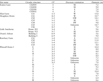
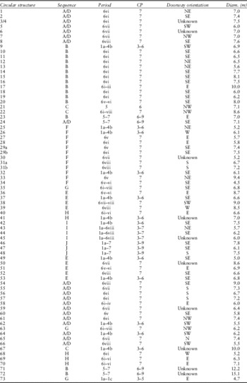
If we begin by examining the suggestion that stake-built houses identified inside Danebury were smaller than contemporary post-ring houses within the surrounding farmsteads, the evidence for this is not as clear-cut as Hill and Stopford imply. The diameters of 35 Iron Age round-houses identified during excavations of the non-hillfort enclosures surrounding Danebury were measured along the longest axis between the outer rings of post-holes (see Appendix). This illustrated that all the houses possessed a diameter in the range of 5.6–15 m. The mean diameters by ceramic phase are presented in Table 4. More than 70 circular structures were identified at Danebury (Appendix). When the diameters of the outer rings of stake-holes were measured, the mean house size was 7.2 m, well within the range of house sizes on non-hillfort sites.
Table 4 mean diameters of round-houses at danbury (n = 73) and non-hillfort sites (n = 35) in hampshire

Yet, if we compare the mean house sizes by ceramic period, the evidence implies that the houses on non-hillfort sites were much larger than at Danebury during cps 1–5. However, this is likely to be a result of the absence of very substantial houses at Danebury, belonging to the Earliest Iron Age (cps 1–2) like those that have been identified in some of the surrounding farmsteads such as Flint Farm (Cunliffe and Poole Reference Cunliffe and Poole2008). Given that there is no occupation at Danebury until cp 3, if the measurements of the large Earliest Iron Age houses (cps 1–2) are removed from the non-hillfort house sample, then the mean diameter is only 8.3 m, much closer to the Danebury houses.
The variation of constructional techniques used to build round-houses on hillfort and non-hillfort sites also needs to be considered. There were no convincing post-ring round-houses identified during the Danebury excavations and the majority of circular structures were stake-built. By contrast, the ground plans of post-ring round-houses have regularly been recorded at smaller, non-hillfort, enclosed settlements such as Winnall Down (Fasham Reference Fasham1985) and Little Somborne (Neal Reference Neal1980). That is not to say, however, that stake-built circular structures could not work as habitable structures. Cunliffe (Reference Cunliffe2003, 86) has argued that stakes, interwoven with wattle work and finished with daub, could create a substantial and rigid wall, quite strong enough to support the weight of a conical roof or allow some of the verticals to be taken up to form a roof. The resulting house at Danebury was, then, potentially a permanently occupied structure similar to contemporary post-ring round-houses.
It seems reasonable to suggest, therefore, that at least some of the houses at Danebury were occupied all year round. If this is the case then it is interesting to question why there was variation in the constructional techniques of round-houses at Danebury and the surrounding smaller enclosures. One possibility is that stake-built houses were much more widespread than is currently thought, but they have not survived to be recovered by archaeology within the heavily ploughed interiors of the smaller enclosures. An alternative is that different construction techniques were a means of expressing different constructions of identity. In particular, the way in which raw materials for building were obtained and used may have made important statements about ethnicity, locality, and social relationships. For instance, a wide variety of timber would have been required for the construction of a round-house. Post-ring structures would have required a large number of complete or cleft trunks whereas stake-built structures would have needed many coppiced poles. The embodied processes of obtaining materials would have created a web of relationships between people and places and have been a key mechanism for creating placedness.
House orientation
The orientations of Iron Age round-house doorways have conventionally been viewed as a result of environmental factors such as shelter from prevailing winds or maximising the penetration of light (Hingley Reference Hingley1984, 63). Yet, in the late 1980s and 1990s the social and symbolic aspects of house construction became an important new focus (Wait Reference Wait1985; Boast & Evans Reference Boast and Evans1986; Hill Reference Hill1996; Oswald Reference Oswald1997; Parker Pearson Reference Parker Pearson1996). In particular, the structuring of domestic space according to cosmological principles was emphasised (Parker Pearson Reference Parker Pearson1996). One pattern to have emerged from these studies is a preference for house entrances to face between east and south-east. The cosmological model has been critiqued in more recent years (e.g. Pope Reference Pope2003; Reference Pope2007), but the idea that houses were built to a social or cosmological template is convincing (see especially Oswald Reference Oswald1997, fig. 10.4; Sharples Reference Sharples2010, chap. 4). Parker Pearson (Reference Parker Pearson1996) has even argued that it was the porch or doorway of the house, and not the hearth, which was the prime element in house form.
An analysis of Iron Age house doorway orientations from non-hillfort settlements in Hampshire confirms this pattern with around 75% of entrances facing east or south-east (Fig. 4). However, a far greater proportion of houses were orientated to the east or south-east during the Middle–Late Iron Age (cps 6–9) than during the Early Iron Age (cps 1–5), which may suggest an increasing concern with following socially accepted architectural conventions. But what of the Danebury houses? Hill (Reference Hill1996, 104) has argued that hillforts were places outside the normal daily structures and practices and so we should expect the breakdown of the rigid spatial rules governing entrance orientation. Parker Pearson and Richards (Reference Parker Pearson and Richards1994, 54) have even suggested that within hillforts the eastern orientation of round-house doors was replaced by an arrangement where most entrances faced towards the centre of the hillfort, although this is clearly not the case.

Fig. 4 Round-house doorway orientations from non-hillfort sites in Hampshire (n = 35)
Fig. 4

If we plot the orientations of all the Iron Age round-house entrances at Danebury, it is clear that more than 60% of doors faced east or south-east (Fig. 5). This is broadly consistent with the evidence for entrance orientations from non-hillfort sites, and suggests that widely held rules structuring domestic architecture may have existed. Some houses, such as CS 1, even appear to have been deliberately located so that their doors were orientated east, even if it meant facing the tail of the inner rampart (Cunliffe & Poole Reference Cunliffe and Poole1991, fig. 4.110). This seems to go against the ideas mentioned above promulgated by Hill (Reference Hill1996) and Parker Pearson and Richards (Reference Parker Pearson and Richards1994).

Fig. 5 Round-house doorway orientations from Danebury (all periods) (n = 73)
However, Figure 6 shows the orientation of Danebury round-house doors by period. This illustrates that during periods 1a–4b around 54% were orientated somewhere between east and south-east. There were also 27% orientated south-west. These figures are consistent with those from contemporary smaller enclosures (see Fig. 4, cps 1–5). However, by period 6i the proportion of doors orientated in a westerly direction was only 13% while there was a particularly high proportion of doors orientated to the east. This pattern is consistent until period 6vi when almost 90% of house entrances were orientated somewhere between north-east and south-east. This may suggest a desire to emphasise the conformity of structuring domestic space. It may be significant that the two houses with house doors orientated to the north-west had diameters of around 9 m, which is approaching the maximum range of house sizes and marks them out as different (cf. Parker Pearson Reference Parker Pearson1999). After period 6vi there appears to have been a reversal of this pattern and a less rigorous eastern orientation of doorways.

Fig. 6 Round-house doorway orientations from Danebury by periods 1–7 (Period 1a–4b n = 11; Period 5 n = 4; Period 6i–6iv n = 8; Period 6v n = 14; Period 6vi n = 26; Period 6vii n = 8; Period 6viii n = 12; Period 7 n = 2)

Fig. 7 Comparative plots of occupation in stratified sequences arranged by period (1–7) (based on Cunliffe Reference Cunliffe1995, figs 56–88)
The orientation of round-house entrances at Danebury clearly expressed certain structuring principles, although these did not remain unchanged. For Parker Pearson (Reference Parker Pearson1996) eastern entrances to round-houses were focused on the rising sun, which equated to rebirth, life, and good as well as men and women, domestic tasks, and animal species. Structuralist logic would therefore dictate that western entrances were considered the opposite. According to these principles, the changes over time we observe at Danebury to round-house doorway directionality were associated with subtle alterations to the relationships between men, women, animals, and practices. For Parker Pearson and Richards (Reference Parker Pearson and Richards1994, 54) the purposeful manipulation of cosmological principles brought together concerns with place and the localised control of space and people.
The cosmological model has begun to be critiqued in recent years, although an adequate alternative has not been forthcoming. Brück (Reference Brück1999) and Webley (Reference Webley2003) have stressed that the structural principles that underlie the model deny human agency and they highlight the diversity in the archaeological record, while Woodward and Hughes (Reference Woodward and Hughes2007) and Pope (Reference Pope2003) have challenged the validity of the model when tested against large datasets. Pope (Reference Pope2007) has rightly highlighted that the cosmological model relies heavily on the uncritical use of analogy. She has even suggested that people designing round-houses had both structural and spatial concerns in mind, which allowed for multiple conscious and subconscious possibilities of organising space. Yet, this fails to provide an adequate explanation for the orientation of doorways, particularly in those cases where the doorway was positioned awkwardly in order to follow an easterly orientation.
Can we envisage an alternative explanation for the orientation of doorways at Danebury? One possibility is that the increase in the proportion of houses with east or south-east facing entrances in period 6i reflected an increasing desire to emphasise the similarity of domestic space. By period 6vi, almost 90% of house doors conformed to an eastern orientation. This manipulation of entrance orientation may have been a strategy to blur the distinction between the houses and identities of individual families and emphasise the importance of the hillfort community. If we extend the logic to periods 6vii–viii then the decrease in the proportion of doorways orientated to the east may have reflected a change in the nature or articulation of the identity of the hillfort community.
Danebury: Building a Hillfort Community
The final volume of the Danebury excavations report is subtitled ‘a hillfort community in perspective’ (Cunliffe Reference Cunliffe1995). But, what exactly is meant by the term ‘hillfort community’? For Cunliffe (Reference Cunliffe1995; Reference Cunliffe2003) the Danebury hillfort community was composed of a resident religious or secular elite who lived in the hillfort and controlled a large territory of surrounding fields and farmsteads. Relationships of clientage linked the hillfort dwellers to the lower status farmers of the countryside. This community of nobles and their clients made up the tribe whose boundaries were defined by the linear ditch systems. Others see Wessex hillfort societies as being very communal in emphasis (Bowden & McOmish Reference Bowden and McOmish1987; Hill Reference Hill1995; Sharples Reference Sharples1991; 2010; Barrett Reference Barrett2000). For Sharples (Reference Sharples1991) power was associated with communities and derived from agricultural production, and manifested itself in the defence of the community and the storage and control of its produce. These were large self-sufficient communities of economically and socially interlinked settlements. Hill (Reference Hill1995, 53) has argued that we should consider hillforts as symbols of the community. Barrett (Reference Barrett2000, 319), on the other hand, has suggested that the way in which the ramparts of some hillforts were refashioned increased the social isolation of the hill and emphasised the residents’ identity as enclosed and withdrawn from the wider community.
Given the paucity of evidence for a highly stratified Iron Age society in Wessex, it is unlikely that hillforts were the residences of an elite. Rather, they were the results of considerable communal investment of labour and resources. Hillfort communities for Fleming (Reference Fleming1985) were at the tertiary level of social organisation. These were large socio-political groups that could organise labour to defend a territory or construct a hillfort. If this was the case, then how were such communities organised? In particular, who lived in and visited hillforts, and what motivated people to construct and maintain their defences? This paper has emphasised how fluid the complex webs of social relationships and mutual obligations were between households and their neighbours. The concept of a hillfort community, the people who lived in, used, and visited Danebury, therefore necessarily involves the convergence of locality, place, social relations, and collective identity (cf. Tullett Reference Tullett2010).
To explore this concept, let us begin by examining the evidence for the people who lived in and visited Danebury. It has already been argued that there was likely to have been a permanent resident population. This need not necessarily have been very large, especially in the Early Iron Age. Cunliffe (Reference Cunliffe1984) identified only 14 houses belonging to periods 1a–4b. An analysis of the available floor area, assuming one person to every 10 m2, gives an estimated population of around 44 persons. If we assume that an equal number of houses remain unidentified in the unexcavated parts of the hillfort, then an Early Iron Age population of around 80–90 persons seems reasonable. Of course, this number may be significantly fewer if we consider that not all the circular structures may have been in use at the same time or were necessarily for habitation. However, this number suggests the presence of multiple households, and a population size representative of a neighbourhood group. Using similar logic, the resident population during the Middle Iron Age was likely to have been around 230–250 persons, although a population of this size was unlikely to have been maintained consistently and the variable evidence for houses during this period indicates a fluctuating population.
It is not easy to unravel the age and gender composition of the resident hillfort group. A considerable variety of deposits of human bone were recovered during the Danebury excavations. At least 91 individuals were represented by various deposits of whole bodies, incomplete skeletons, partial articulated skeletons, and skulls (for a detailed review of human remains see Cunliffe & Poole Reference Cunliffe and Poole1991, 418–9). Cunliffe has argued that the human remains deposited within the hillfort do not represent the totality of the population since it is likely that the bones that found their way into pits and ditches were selected by certain processes unrecoverable to archaeology (ibid., 424). However, an examination of deposited human remains by age and sex shows that, after a neonatal peak, the death rate was consistent for the first 30–50 years of life (Fig. 8). Very few individuals were older than 50 years. The mortality profiles are similar to those identified at other Iron Age sites throughout Hampshire (see especially Fasham Reference Fasham1985) where few adults survived beyond 30 years of age.

Fig. 8 Human remains recovered from Danebury (all periods) (n = 68) (based on Cunliffe Reference Cunliffe1995, table 13)
However, there is a considerable disparity between the numbers of males and females. Interestingly this pattern is the opposite of that observed at some non-hillfort enclosures such as Winnall Down, where the majority of burials were neonatal infants and 80% of the adult burials were female (Bayley et al. Reference Bayley, Fasham and Powell1985, 119–22). Analysis of osteoarthritic lesions on human bones from Danebury is also instructive. At Winnall Down, numerous instances of oesteoarthritis were observed in the vertebrae, arms, and shoulders of all the adult female skeletons (ibid., 120). However, at Danebury instances of spinal oesteoarthritis were rare or mild suggesting some individuals were not involved in repetitive heavy manual labour (Cunliffe & Poole Reference Cunliffe and Poole1991, 427). That some of the individuals buried appear to have suffered severe and violent wounds immediately before death (see Cunliffe Reference Cunliffe2003, fig. 41) should remind us that violence would have been endemic and social relationships between households and their neighbours may in some cases have led to violence, vendettas, and blood feuds (see also Craig et al. Reference Craig, Knüsel and Carr2005).
Taken together, the evidence indicates that burial of human remains at Danebury was the outcome of a socially controlled selection process of individuals who probably did not all reside permanently in the hillfort. That a large non-resident population used Danebury is attested by the plant remains recovered during the excavations. Weed seeds such as sheep's sorrel (Rumex acetosella) and corn marigold (Chrysanthemum segetum) were identified in the cereal grain assemblage. These weeds are intolerant of the chalk and are associated with acid soils such as clay-with-flints (Jones Reference Jones1984). These deposits can be found around 5 to 10 km to the north of Danebury and suggest that cereals were brought in from a wide range of environments, some beyond the optimal distance for practical farming from the hillfort (Jones Reference Jones1984).
It is very likely, therefore, that there was movement of grain and people from the surrounding farmsteads into the hillfort at certain times of the year. Cunliffe (Reference Cunliffe2003, 112) has suggested that some of the grain may have come into the hillfort after initial stages of preparation, such as threshing, had been completed. This has important implications for the way that Iron Age peoplehood, or community, was constituted through agricultural practices. For some agricultural practices such as harvesting, threshing, and storage it is likely that the labour and resources of a neighbourhood group would have been pooled. Labour was probably further organised into small groups of family, kin, and neighbours in which personhood was related to the performance of specific tasks in specific localities. Threshed grain would, therefore, have been the result of a series of mutually dependent relationships of several households and their neighbours. In this sense, threshed grain brought to Danebury would have been considered as the produce of a neighbourhood group and a referent of collective household identities.
Cunliffe (Reference Cunliffe1984) has argued that this grain was brought to Danebury as a tithe or tribute and subsequently redistributed to the surrounding population. This seems unlikely and Hill (Reference Hill1996) has convincingly argued that non-hillfort settlements could have stored ample cereals so that they were not dependent upon grain redistributed from hillforts. Sharples (Reference Sharples1991) has suggested that the vast grain stores at Maiden Castle were used to feed the large number of labourers who came to the hillfort from the surrounding communities to work on the ramparts. For Sharples, the removal of grain supplies from the surrounding communities would have been a means for the community at Maiden Castle to control their lives and actions (1991, 90).
Can we envisage a similar situation at Danebury? In the Early Iron Age (periods 1a–5) the enclosed settlements surrounding the hillfort were clustered together into neighbourhood groups that were cross-cut with kinship ties and webs of cooperation. In turn, these groups would have been combined into a larger community of shared interests, such as the defence of communal and individual household resources and people. The construction and maintenance of Danebury's defences may have been a way for a dispersed population to see themselves as sharing localities and identities, and to reproduce a sense of community. However, the defensive aspect of the ramparts should not be dismissed out of hand in favour of such a nuanced symbolic interpretation. Recent analysis by Armit (Reference Armit2007) has emphasised that Iron Age communities did attack one another and the fortified settlements should be considered as defensive within the historically specific conventions of the time. In this sense the impetus for the reworking of the ramparts may have been the threat of inter-communal violence.
People associate the idea of community with people they know, with whom they have shared practices, experiences, places, and histories. The experience of community would have occurred through commonplace events and everyday practices, but was reinforced through unusual activities such as rampart construction and maintenance. The ramparts at Danebury were subject to periodic modifications, although the ditches show evidence of more regular cleaning out. A single section excavated through the main defences (rampart 1) in 1969 showed a series of tips of material built up as a counterscarp (Cunliffe Reference Cunliffe1995, 23). Around 17 tips were identified, although more may have been destroyed by the progressive widening of the ditch over time. At least four episodes were discernible from the counterscarp of the rampart 2 ditch. It is not possible from this single section alone to give the precise number of clearance episodes, but a conservative estimate based on 450 years of occupation would suggest one event every 26 years, or each generation. This suggests that boundary renewal was integrated into the rhythms of individual and family lifetimes.
The evidence for boundary maintenance suggests that the labour forces would have been assembled on a periodic basis. Taking part in such projects was one way that networks of debt and obligation could be created between members of the hillfort community, as well as a means of establishing and affirming the social standing of households and their rights of access to particular land. Co-operative labour organisation would have been common and well developed. Fleming (Reference Fleming1985, 142) has argued that, within such a collective system, most members would have had an interest in strengthening or maintaining the system. Economic or socially dominant households would have wanted to consolidate their position, while poorer groups would have struggled to maintain their share in community. In this sense repeated acts of rampart care and maintenance brought these groups together for one communal purpose that confirmed alliances and claims to place. As claims over particular places changed from one generation to the next, groups could close down access to land by withdrawing their co-operation from these projects.
The biographies of particular households would have become attached to Danebury through the tending and reworking of the defences. The embodied practices of shared labour would have produced a sense of place and a place relation between households and the hillfort. In this sense rampart maintenance confirmed and reaffirmed reciprocal relationships between kin, neighbours, and the broader community, but also reinforced a sense of belonging and place.
Changing places, changing community
One of the most important changes that took place over the Middle Iron Age was the degree to which land and resources were shared communally. The relatively enclosed landscape of the Early Iron Age was increasingly opened up, reflecting a change of land tenure from the neighbourhood group to the broader community. Some neighbourhood groups that had exploited land within about a 10 km radius of Danebury in the Early Iron Age, combined together and clustered into the hillfort into a single co-resident community (Davis Reference Davis2010).
The pottery evidence suggests that this hillfort community regularly used resources from a long distance away. Morris (Reference Morris1997, 37) has argued that the proportion of non-locally produced pottery vessels made from glauconitic sandy fabrics increased during the Middle Iron Age and came to dominate the entire ceramic assemblage. The source of the clay for these vessels was probably the Upper Greensand clays around Compton Chamberlayne, 30 km west of Danebury. This suggests increased intra-regional (10–40 km) exploitation of clay resources or ceramic exchange in the Middle Iron Age. It is difficult however to assess the role of Danebury within this since glauconitic fabrics are common in Middle Iron Age saucepan pottery throughout Hampshire (see especially Holmes et al. Reference Holmes, Matthews and Rees2004; Hawkes Reference Hawkes1985).
The pottery evidence reminds us that, rather than seeing hillfort communities as neat units with clear spatial limits, households and communities may have simultaneously been part of fluid networks of co-operation and associations. Some of these networks may have been short-lived, but others would have been of longer duration. Investment of time, labour, and resources in the construction and maintenance of hillfort defences may have been one way of maintaining networks in the long term. At Danebury, after period 5 (c. 270 bc), however, the defences were not increased in size. This is interesting given that period 6 (c. 240 bc) coincided with a major reorganisation of settlement within the interior of the hillfort. Although minor refurbishments and cleaning of the ditches may have occurred during period 6, it would appear that the principal phases of rampart construction had come to an end. This indicates a change in the articulation of community by individuals and households.
Cunliffe (Reference Cunliffe1995) has argued that occupation in the quarry hollows may reflect specific ownership of domestic space established during the construction of rampart 3 when material was won from these areas. Yet ownership implies responsibility and exclusive rights and control over property. I think ownership in these terms is unlikely to have existed. The evidence from Danebury actually suggests frequent reordering of the domestic space in the lee of the ramparts. As we have already seen, the association between Iron Age people and place was established through the performance of embodied practice. The digging of ditches around houses, such as at Early Iron Age Winnall Down, was just such a means of creating placedness. At Danebury, the digging of the quarries was a means of creating a place relationship between people and the hillfort. Subsequent occupation in these localities did not reflect ownership, but referenced the biographies of individuals and households who had become intertwined with this place.
Conclusion
This paper began by examining Cunliffe's interpretation of Danebury and has emphasised the continuities and discontinuities of use to highlight that Danebury is not a type site. By examining patterns of activity within the interior of the hillfort it has been possible to demonstrate that the nature of the community that resided in Danebury changed considerably over the course of the Early and Middle Iron Age. In particular, it has been argued that Danebury was occupied by a permanent population, which was likely to have been swelled at particular times of the year, such as after harvest, by seasonal visitors. The organisation of domestic space, however, was tightly managed. In the early period (470–270 bc) occupation was characterised by single round-houses separated by 10–15 m. These were individual household units emphasising their distinctiveness by spatial isolation and variability in round-house design. A dramatic change in the nature and intensity of occupation came in the late period (270–50 bc). A large number of identikit round-houses were tightly packed into the quarry hollows in the lee of the ramparts. This probably represents households from the surrounding settlements moving into the hillfort. The similarity of round-house size and entrance orientation may have been an attempt to blur the distinction between households.
Finally, it has been argued that the communal construction and maintenance of Danebury's defences would have been a way for a dispersed population to have reproduced a sense of community. The biographies of particular households would have become attached to this place through their participation in the occasional reworking of the defences, reinforcing links to an ancestral past when previous generations helped to build the communal monument. Participation may also have been a mechanism for maintaining networks and relationships with other households in the long term.
Acknowledgements
My thanks are extended to Alisdair Whittle, Tom Moore, and Niall Sharples who all read and provided detailed comments on previous versions of this paper.
APPENDIX: ROUND-HOUSE DATA
a. Round-houses at Danebury
b. Round-houses at non-hillfort sites