INTRODUCTION
Paleosols buried under archaeological sites are natural “archives” where information about past environments is stored. The overwhelming majority of studies in archaeological pedology are focused on burial mounds (kurgans) in Russia (Gennadiev, Reference Gennadiev1990; Ivanov, Reference Ivanov1992; Demkin, Reference Demkin1997; Dergacheva, Reference Dergacheva1997; Alexandrovskiy, 1996; Alexandrovskiy, Reference Alexandrovskiy2000); while in Europe, the studies of this kind are less common (Limbray, Reference Limbray1975; Goldberg and Macphail, Reference Goldberg and Macphail2006). In the studies of paleosols buried under kurgans, the obtained data on paleoenvironments characterize only a rather short time interval immediately preceding the burial of the studied paleosols. Studies of kurgans of different ages provided materials for compiling a chronosequence of the buried soils and for paleoenvironmental reconstructions covering a longer time interval in the second half of the Holocene. The cases of kurgan assemblages (cemeteries) confined to a limited area, with kurgans being raised successively through the entire period of the kurgan ritual existence, from 6000yrBP to the early Middle Ages, are extremely rare (Morgunova et al., Reference Morgunova, Golyeva, Kraeva, Meshcheryakov, Turetskiy, Khalyapin and Khokhlova2003; Demkin et al., Reference Demkin, Kashirskaya, Demkina, Khomutova and El’tsov2008; Pesochina, Reference Pesochina2013). Even in such cemeteries, there are considerable time intervals when no kurgans were constructed. To fill the gaps—the time intervals when kurgans were not constructed— we have to interpolate the available data into the intervals lacking data (Khokhlova et al., Reference Khokhlova, Khokhlov and Morgunova2004).
There are known, however, earthen sites built by early human (settlements) where material accumulated over a considerable time interval (for instance, from the middle Holocene to the present day). Though some sedimentary layers may have been eroded at one time or another, still they may still contain almost continuous records since the beginning of the sites’ existence (Sorokin, Reference Sorokin2012). Such sites are of special importance, as they shed light on the Holocene intervals poorly represented in the paleosol sequences below kurgans, in particular, the Atlantic period of the Holocene (7500–5000 yr BP). The kurgan rite arose in interfluves of the Volga and Ural rivers rather late in the Atlantic period (Merpert, Reference Merpert1974). Besides, kurgans dating back to such an early age are exceedingly rare.
In the present study, the multi-layered Turganik settlement in the Tok River valley (steppe area of the Cis-Urals, Orenburg Region, Russia) was investigated using an integrated (paleopedological and paleobotanical) approach. The study is aimed at reconstructing paleoenvironmental conditions, climate and vegetation in particular, for the entire period of the settlement’s existence.
LOCATION AND SETTING
The Turganik settlement in the Orenburg Region constitutes part of the so-called Ivanovo microregion of cultural heritage monuments, along with the Mesolithic Starotokskaya site; an Ivanovskoye multi-layered settlement (Neolithic, Eneolithic [or Chalcolithic], Late Bronze Age); Toksky I and Toksky II settlements attributed to the Late Bronze Age (the Timber-Grave archaeological culture); an Ivanovsky ground burial dated to the Eneolithic; and the Ivanovsky kurgan cemetery of the Early Iron Age (Fig. 1).
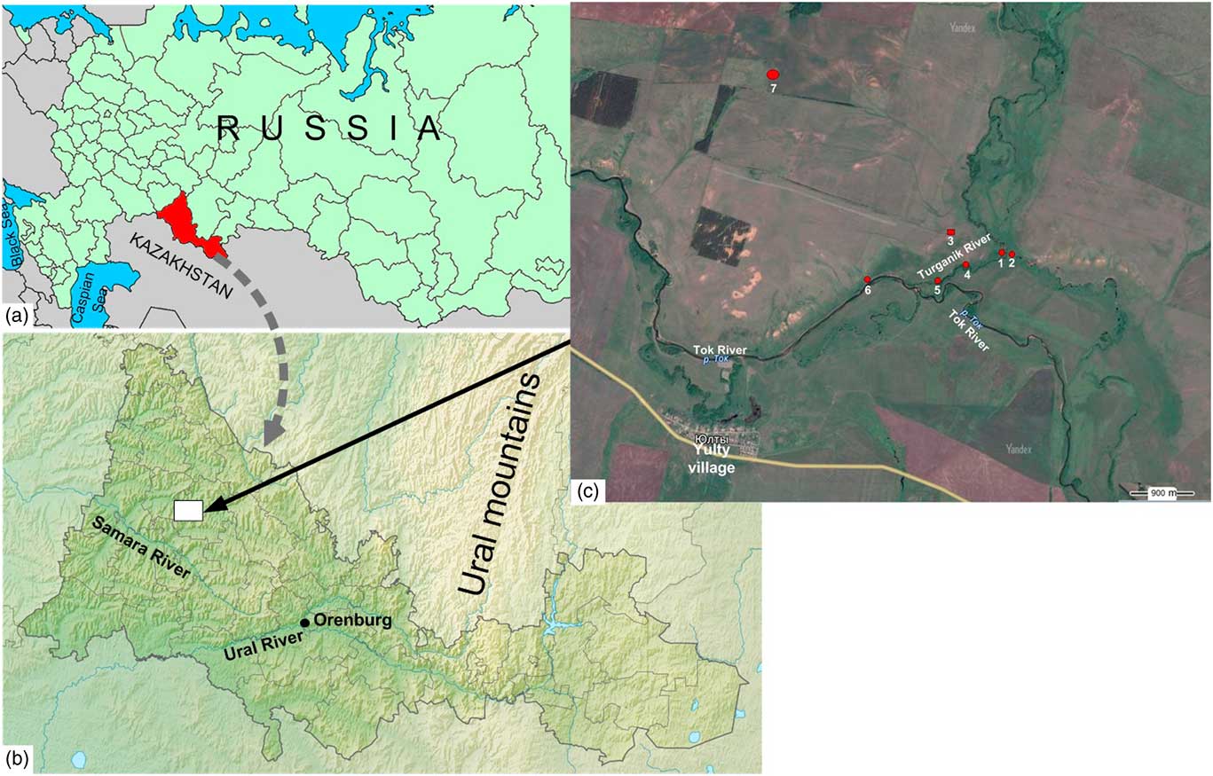
Figure 1 (color online) (a and b) Location of the studied region and (c) the objects of the cultural heritage in the microregion: 1, Turganik settlement; 2, Toksky II settlement; 3, Ivanovsky dune with Ivanovsky ground cemetery; 4, Ivanovskoye II multi-layered settlement; 5, Staro-Tokskaya site; 6, Toksky I settlement; 7, Ivanovsky I kurgan cemetery.
The ancient settlements are located at the Turganik River mouth, where the river joins the Tok River (the Samara River drainage basin). The Turganik River enters an old channel of the Tok which continues to flow due to that fact. Both valleys are wide and dissected by multiple river channels. The floodplain landscapes are mostly wet meadows with rich herb and grass vegetation, pastures, and hay fields. On both sides of the Turganik River, and farther along the right side of the Tok valley there are flat-topped elevations, with occasional forests (Chibilev, Reference Chibilev1996). The Turganik settlement was positioned on a slightly elevated surface at the confluence of the Turganik and Tok rivers, on the right side of the valley. The settlement was inhabited in the Eneolithic and the Late Bronze Age, the fifth to fourth millennia BC.
The studied area is at the extreme east of the East European Platform, within the limits of Obshchiy Syrt Upland. The latter is a kind of stepped structural surface with some residual outliers of planation surface typical of the studied region (the central Orenburg Region). The soil parent rocks are the Quaternary loams and clays. Among the parent rocks, there are some admixtures of red rocks attributed to the Tatar Stage of the Permian System; that accounts for the brownish or reddish hue of the soil horizons that developed in the region.
The studied region belongs to the subzone of northern herb and grass steppe with sheep’s fescue (Festuca sp.) and feather grass (Stipa pennata) on Ordinary Chernozems (Erokhina, Reference Erokhina1959) or on Calcic Chernozems (IUSS Working Group WRB, 2014). The proportion of ploughed area is high (more than 63%), while the percentage of forested land area is very low and amounts to 0.7% at present. The climate is continental, with average long-term temperatures varying over a wide range (about 15°C). The mean temperature is 21°C in July and –15°C in January. Mean annual precipitation is 360 to 410 mm. The snow cover lasts for 145–150 days; its depth at the end of winter is 30–40 mm. The frost-free period is 130 days long on average. The sum of temperatures above 10°С exceeds 2600°С (Geographic atlas of Orenburg Region, 1999).
MATERIALS AND METHODS
Archaeological excavations
The excavations of the site were performed in two stages. The settlement was first excavated in 1981–1982, when cultural layers were identified as belonging to the Eneolithic, Bronze Age, and early Middle Ages. There was a dark-gray humus horizon with pottery described above the lower Eneolithic layer and tentatively assigned to the Early Bronze Age; its cultural and chronological position was not determined conclusively due to its difference from previously known cultures of that stage (Morgunova, Reference Morgunova1984). Later on, after some ceramic fragments had been radiocarbon dated, the cultural remains were attributed to the Early Bronze Age (Morgunova, Reference Morgunova2014). Still, a few problems as to the ceramics chronology and its cultural attribution remained unsolved. The most serious doubts were raised in connection with the radiocarbon ages being older than formerly accepted ages (Kuznetsov, Reference Kuznetsov2013). Thus, the excavations of the settlement were resumed in 2014–2015. About 800 m2 have been excavated altogether (including the area opened in 1982). The stratigraphy is uniform all over the area, as is the thickness of cultural and barren layers. Six paleosol horizons have been identified; the four upper ones, up to 60 cm thick, are completely devoid of artifacts. The only exception is the uppermost layer yielding some medieval pottery fragments.
The lower part of the sedimentary sequence appears to include two cultural layers: the lower one contained predominantly Eneolithic ceramics, while the ceramic items recovered from the upper layer are confidently attributed to the Early Bronze Age. Judging from the morphological and technological characteristics of the Eneolithic ceramics, they were definitely related to the Samara culture (the second stage in the evolution of the latter). That, together with the presence of some objects directly imported from the Khvalynian culture typical for the steppes in the Volga drainage basin, gave grounds to correlate the layer with the Khvalynian culture (Morgunova et al., Reference Morgunova, Turetskii, Kulkova and Nesterova2016b). The data obtained from integrated studies of the early Bronze ceramics confirmed its attribution to the early (Repino) stage of the Pit-Grave culture (Morgunova and Salugina, Reference Morgunova and Salugina2016; Morgunova et al., Reference Morgunova, Salugina and Turetskii2016a).
A series of 32 radiocarbon ages obtained on animal bones and various ceramic fragments collected from all the excavated areas and taken from different depths permitted the cultural layers and related materials to be reliably dated (Morgunova et al., Reference Morgunova, Turetskii, Kulkova and Nesterova2016b). The ages formed three groups, two of them falling within the Eneolithic epoch. The older of the two (4898–4440 ВС) corresponds chronologically to the Khvalynian burial grounds, the ceramics recovered from the latter closely resembling those from the Turganik cultural layer (Shishlina, Reference Shishlina2007; Chernykh and Orlovskaya, Reference Chernykh and Orlovskaya2010), as well as the materials of the Khvalynian type found at the settlements of the Samara region of the Volga drainage basin (Korolev and Shalapinin, Reference Korolev and Shalapinin2014). The second interval was dated by radiocarbon to 4237–3790 ВС on samples of the Toksky type ceramics (the late stage of the Samara culture). The same stage is distinguished by the presence of Surtandy and Novoilyinka type ceramics typical of the Transuralian regions and the Kama drainage basin at that time. Both may be assigned to the late stage of the Eneolithic epoch. The cultural layer attributed to the Early Bronze Age was dated to the interval of 3800–3360 BC, correlatable with the early (Repion) stage of the Pit-Grave culture in the Cis-Ural steppe (Morgunova, Reference Morgunova2014).
Analysis of paleosols
The studies of paleosols were performed on the Turganik settlement in 2015. The excavation wall was hidden under 50 cm layer of waste left by the previous excavations. The wall was described in details, photographed, and sampled for various kinds of analysis.
Analytical studies were performed at the Center of Common Facilities of the Institute of Physicochemical and Biological Problems in Soil Science, Pushchino, Russia. The grain-size analysis for fine earth (<1 mm) was performed by conventional pipette method with sodium pyrophosphate pretreatment (Kachinskiy, Reference Kachinskiy1965) to appropriate texture classes. Particle size distribution was established according to the Russian conventional fraction groups, physical sand (fraction >0.01 mm), physical clay (fraction <0.01 mm), and clay (fraction <0.001 mm). The organic carbon content was determined according to the Tyurin method of wet combustion with potassium dichromate and concentrated sulfuric acid. The carbonate CO2 was determined by chromatography in sealed vessels with rubber stoppers in which the samples reacted with 10% HCl solution and were then converted to C. The content of SO4 gypsum was analyzed by weighing: the method is based on the precipitation of the sulfate ion by barium chloride, the weight of the calcined BaSO4 precipitate is recalculated to SO4. The sum of exchange bases was determined by way of replacement with ammonium acetate, K, and Na to be determined subsequently by flame-photometer, and Ca and Mg by complexometry (Vorobieva, Reference Vorobieva1998). Soil acidity was determined in water extract (soil and water are in a ratio of 1:5) and loss on ignition at 900°C (Arinushkina, Reference Arinushkina1970).
The concentrations of macro- and microelements were measured by the X-ray fluorescence analysis (XRF) using the sequential (wavelength dispersive) vacuum spectrometer, Axios mAX model, produced by PANalytical Company (the Netherlands, 2012). The macro- and microelements were analyzed in the Laboratory of the Mineral Matter Analysis, Institute of the Ore Geology, Petrography, Mineralogy, and Geochemistry, Russian Academy of Sciences. The geochemical coefficients were calculated from the data on the bulk composition for every studied layer. Samples with undisturbed structure were taken from every described layer and thin sections were prepared. They were studied using a polarized-light microscope (Carl Zeiss HBO 50, Germany) at the Center of Common Facilities of the Institute of Physical, Chemical and Biological Problems in Soil Science, Russian Academy of Sciences located in Pushchino, Russia, and described according to Stoop’s (Reference Stoops2003) terminology.
Microbiomorphic analysis
Microbiomorphic analysis is the microscopic investigation of detritus, phytoliths, sponge spicules, and other remains of biota for the reconstruction of ancient pedogenic conditions. Each microbiomorph is associated with certain types of landscape, and provides information on conditions of soil development and on landscape evolution (Golyeva, Reference Golyeva2001). The main method of microbiomorphic analysis is the consecutive study of individual kinds of biomorphs under the microscope. The amount of 50 g of samples were treated with a hot 30% solution of H2O2, separated from sand and clay, and subjected to flotation in a heavy liquid (cadmium iodide and potassium iodide with a specific gravity of about 2.3 g/cm3). After a 10-minute centrifugation, the floating siliceous and other biomorphs were collected into a tube and washed with distilled water several times, then immersed in oils (silica oil or glycerin), and studied under the optical microscope at 200–900× magnification. Quantitative content of silica microbiomorphs was assessed following the methodology published by Albert and colleagues (Albert and Weiner, Reference Albert and Weiner2001; Albert et al., Reference Albert, Bar-Yosef, Meignen and Weiner2002). We counted all the morphotypes we found per whole slide. Analyzing the entire complex of soil microbiomorphs enables one to determine the entire spectrum of particles from one sample. Interpretation of the phytolith assemblages in terms of ecology and environments is given according to Golyeva (Reference Golyeva2007), who characterized phytolith assemblages from different ecological zones of the Russian Plain. In addition, the results of the microbiomorphic analysis were compared with pollen analysis data obtained in the 1980s, when the Turganik site was first excavated (Lavrushin and Spiridonova, Reference Lavrushin and Spiridonova1995).
RESULTS
Profile description
The studied column was designated in the field as Tr1b-15 and included seven layers (Fig. 2). The column was described from the top downward, with the boundary between the buried surface and the overlying dumped soil being taken as the initial point.
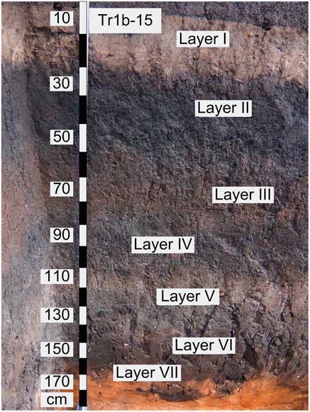
Figure 2 (color online) Morphology of the studied sequence, Tr1b-15, and the position of the identified layers.
Layer I, 0–20 (22) cm or 50–70 (72) cm from the dump surface (henceforth, the depths of layers are indicated without regard for the dump thickness), is a medium loam with granular structure, densely penetrated with roots, and is gray-brown (10 YR 5/2) with a pale yellowish hue (10YR 6/4).
Layer II, 20 (22)–50 (55) cm, is a very dark gray (7.5 YR 3/1) medium loam with a coarse crumby and granular structure; roots are less abundant compared to layer I.
Layer III, 50 (55)–70 (80) cm, is dark gray with a brown hue (7.5 YR 4/3) and very dense, with nutty structure easily destroyed to dust under pressure; boundaries are quite indistinct (due to appearance of carbonates in the lower part). The presence of the carbonate efflorescence makes visible an indistinct columnarity. Roots are rare and do not penetrate into the lower layer.
Layer IV, 70 (80)–100 (105) cm, is dark gray with whitish efflorescence of carbonates (10 YR 4/2). Stone rubble is present in abundance and is traceable to the bottom. Both the soil consistency and structure show columnar features, at least in fragments; the deposits become more clayey downward.
Layer V, 100 (105)–135 cm, is whitish due to abundant carbonates (7.5 YR 6/3) and columnar structure is distinctly seen when dried.
Layer VI, 135–150 (155) cm, is dark gray with a whitish hue (10 YR 4/3), locally black with a hint of blue (10YR 2/1), and poorer in carbonates. The structure is nutty-columnar and easily crushed into small crumbs when scraped.
Layer VII, 150 (155)–180 (185) cm. The color abruptly changes from dark gray to brown, with a reddish hue (2.5YR 4/6). There are holes of burrowing animals filled with dark matter, the latter having a well-pronounced bluish hue. In general, the material is structureless.
Total phosphorus
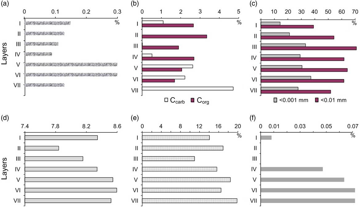
As follows from the chemical analysis results, elevated concentrations of the total phosphorus (Р2О5) are found in layers V and VI only. The phosphorus concentrations in those layers are as high as 0.30%, while in the uppermost horizon (that may be considered as background, or normal) and in all the other layers they amount to 0.09-0.15% (Fig. 3a). Judging from the distribution of that element, indicative of a human impact (Leonardi, Reference Leonardi1999; Holiday and Gartner, Reference Holiday and Gartner2007), only layers V and VI can be considered cultural layers, whereas the remaining identified units are interpreted as natural formations without human interference.

Figure 3 (color online) The distribution of soil characteristics over the studied layers of the Tr1b-15 sequence: (a) total Р2О5 ,%; (b) Corg and Ccarb, %; (c) fractions <0.001 mm and <0.01 mm, %; (d) pHwater; (e) loss on ignition, %; (f) SO4 of gypsum, %.
Organic and carbonate carbon
The distribution of the organic (Corg) and carbonate carbon (Ccarb) indicates that the deposition of Corg definitely exceeding that of Ccarb in layers I to IV (Fig. 3b), the carbonates being completely absent from layers II and III. Therefore, the upper part of the sequence, layers I–IV, developed mostly in the absence of carbonates under conditions favorable to humus formation.
The cultural layers are characterized by slightly lower Corg content when compared to the overlying horizons. The Сorg content presumably diminished after the soil burial due to diagenetic biomineralization processes (Ivanov, Reference Ivanov1992): the longer a soil stays buried, the less humus it contains. To compare the Corg content in the studied layers, it is necessary to take into consideration the fact that layers V and VI stayed buried for a much longer time than the overlying layers, and the diagenesis and decrease in the Corg content proceeded longer in them. Therefore, it should be admitted that the Corg content in the cultural layers is not very low and could be formerly comparable with (or even exceed) its content in layers III–IV at the moment of the burial of the cultural layer.
The cultural layers display a higher proportion of Ccarb in comparison with Corg content (Fig. 3b, layers V, VI). That is not particularly surprising, taking into consideration that Corg loss is expected in deposits that have been buried for a long time. It should be stressed that the carbonate content in cultural layers is four to five times higher than in the overlying layer IV, the latter being also carbonate-bearing. Finally, layer VII may be considered to be essentially lithogenic (parent rock), it is completely devoid of Corg and features the maximum concentration of Ccarb (up to 5%, i.e., more than 40% of the total mass of the material in terms of CaCO3). The reddish hue noticeable in layer VII suggests solid calcareous red rocks of the Tatarian stage (Permian) to take part (or are predominant) in the layer formation.
Only the uppermost layer I shows the carbonate concentration increasing due to warming and summer droughts recorded by instrumental meteorological observations over the last decades (Platova, Reference Platova2008). It is not inconceivable that the uppermost layer I in the studied area was formed partly of redeposited carbonate-enriched horizons of soils from the vicinities. The surface soils of the vicinities are Haplic qGypsic Calcisols (Endosalic, Sodic).
Particle-size distribution
As follows from the granulometric analysis (Fig. 3c), the uppermost layer is of medium loam, layer II is fine loam, layers III and IV are composed of silty clay, and layer VII is of fine loam in common with layer II. As for the clay proportion (light gray stripes in Fig. 3c), it is the greatest (up to 40%) in the cultural layers V and VI.
Soil pH (H2O)
The obtained values of pH in the water extract vary from 7.8 to 8.6, that is, between weakly alkaline (рН=7–8) and alkaline (рН=8–9) values (Fig. 3d). The values thus obtained are correlatable with data on the carbon content, both organic and carbonate. The least alkalinity (рН=7.8) was recorded in layer II, noted for the highest content of Corg and total absence of carbonates. The cultural layers V and VI show the highest рН (8.5–8.6).
Loss on ignition
The loss on ignition was found as the difference of the soil sample weight before and after heating to 900°C with free access to air. The loss under those conditions includes chemically bound water, humus, CO2 of carbonates, adsorbed gases, and chlorides (Arinushkina, Reference Arinushkina1970). Maximum losses on ignition were recorded in layers V and VII (Fig. 3e), which is in good agreement with the highest proportion of carbonates in those layers.
Gypsum content
Layers II and III are noted for the absence of gypsum, which cannot be detected by the chemical analyses (Fig. 3f). The maximum concentrations of gypsum are recorded in the lower part of the studied sequence, in the lowermost layer VII in particular, which may be attributed to the gypsum presence in abundance in the parent (Permian) rocks. It is worth noting, however, that gypsum content is only slightly lower in the cultural layers.
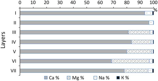
Exchangeable bases
The studied layers differ notably from each other in the composition and proportion of the exchangeable bases. Exchangeable Ca is dominant in the two upper layers, which are completely devoid of exchangeable Mg. The latter first appears in layer III, its proportion is 15–16% in layers III and IV, and reaches its maximum in the cultural layers and in layer VII (up to 28%; Fig. 4). According to data in the literature (Mikhailichenko et al., Reference Mikhailichenko, Parakshin and Tychina1972; Slavnyy and Mel’nikova, Reference Slavnyy and Mel’nikova1977), the exchangeable Mg in common with the exchangeable Na may be the cause of the soil solonetzicity. In the considered case, the most important point is a difference in the exchangeable base composition between the modern upper layers (I, II) and the older, lower ones (III–VII), with the cultural layers being of particular interest. The modern layers are practically depleted of solonetzicity (except for rare cases attributable to the presence a very small quantity of Na), while the exchangeable Mg may be mostly responsible for the solonets properties in the lower layers.

Figure 4 (color online) Distribution of the exchangeable bases over the studied sequence Tr1b-15.
Geochemical indices
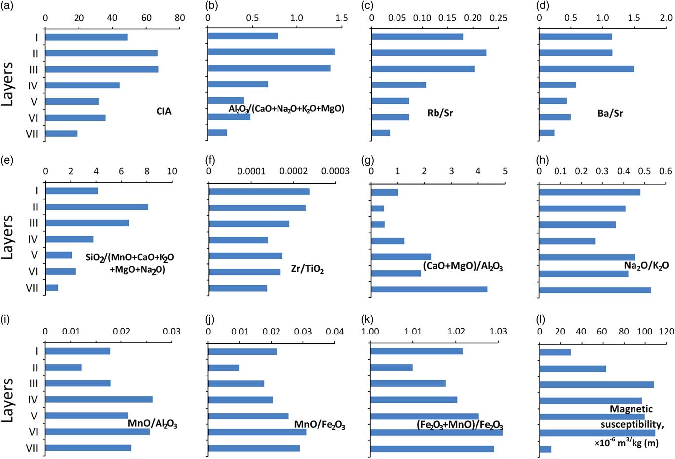
Geochemical indices based on bulk composition and on ratios of macro- and microelements in soil mass (Nesbitt and Young, Reference Nesbitt and Young1982; Gallet et al. Reference Gallet, Borming and Masayuki1996; Retallack, Reference Retallack2001; Pieter et al. Reference Pieter, Vlag, Kruiver and Dekkers2004; Driese et al. Reference Driese, Nordt, Lynn, Stiles, Mora and Wilding2005; Starr and Lindroos, Reference Starr and Lindroos2006; Whitfield et al. Reference Whitfield, Watmough, Aherne and Dillon2006) can be divided into several groups. The first one includes the following known as indices of weathering (Fig. 5):
(a) СIA (chemical index of alteration) is calculated by the formula CIA=[Al2O3/(Al2O3+CaO+Na2O+K2O)]×100; it shows a relationship between primary and secondary minerals in the bulk composition.
(b) Al2O3/(CaO+Na2O+K2O+MgO) displays clay constituent relationship to the major cations removed into soil solutions.
(c) Rb/Sr is the relation of micas and feldspars (with which Rb is associated) to the carbonates associated with Sr.
(d) Ba/Sr is essentially close to the preceding index, except Ba is only associated with feldspars.
(e) SiO2/(MnO+CaO+K2O+MgO+Na2O) characterizes the eluviations processes.

Figure 5 (color online) Distribution of the geochemical indices (a–l) and magnetic susceptibility, ×10–6 m3/kg (m), over the studied layers in the Tr1b-15 sequence.
The above-listed (first) group of the indices of weathering characterizes the processes of leaching and hydrolysis. The result of these processes is that certain chemical compounds are dissolved and removed, while others remain fixed in the soil profile. As follows from the data obtained (Fig. 5a–e), the weathering indices in cultural layers (V–VI) are extremely low when compared with the lowest values of layer VII (slightly weathered parent rock). The weathering indices calculated for layers I–IV show the maximum values, especially in layers II and III.
The only index included into the second group, Zr/TiO2, makes it possible to estimate the homogeneity of the material constituting the layers (Retallack, Reference Retallack2001; Schilman et al., Reference Schilman, Bar-Matthews, Almogi-Labin and Luz2001). Noteworthy is that the greatest values of the considered index are observed in layers I and II (Fig. 5f). The distribution of that coefficient over the layers suggests the two upper layers contain an admixture of some material different in composition from the lower layers. This conclusion is in agreement with the earlier conclusion regarding the exchangeable Na and Mg distribution in the layers under study.
Indices СаО+MgO/Al2O3 and Na2O/K2O form the third group and point to the processes of enrichment in carbonates and salinization (with readily soluble salts). The distribution of the carbonate content index (Fig. 5g) correlates well with the Ccarb distribution over the studied layers (Fig. 3b). This supports the validity of usage of the geochemical index for estimating process of carbonate accumulation. As for the salinity index (Fig. 5h), the readily soluble salts prevail in the lowermost and upper layers (VII and I) as could be expected, as those layers are notable for the greatest proportion of exchangeable Na (Fig. 4). The cultural layers VI and V are also rich in the easily soluble salts. This agrees well with the distribution of losses on ignition. It may be tentatively ascribed to the chloride salt presence in the layers, though they have not been specially analyzed. The “grayish” hue was most characteristic of the cultural layers in particular. It should be kept in mind, however, that the hue may be related not only to a high proportion of carbonates, but to the presence of readily soluble salts (Fig. 2).
The indices attributed to the fourth group are related in one way or another to the redistribution of iron and manganese compounds (Fig. 5i–l). According to the published data (Vlag et al., Reference Vlag, Kruiver and Dekkers2004), these indices are indicative of the level of bioactivity and biological productivity in the sedimentary rocks. We also placed the magnetic susceptibility (MS) of the rocks in this group, as its value depends directly on the presence of iron-containing magnetic minerals, which may be produced by micro-organisms under certain conditions (Schüler and Frankel, Reference Schüler and Frankel1999).
The highest values of the above-cited indices are found in the cultural layers (Fig. 5i–k), and slightly lower values are found in layers IV and VII. The measured magnetic susceptibility values agree with those data (Fig. 5lm). That seems to be at variance with the cited characteristics indicative of a greater carbonate content and salinity in the cultural layers; the data suggest a greater aridity at the time of the deposition of layers, so that the freshly deposited material was hardly subject to physical and chemical weathering in situ. On the other hand, the layers are greatly enriched with Mn and Fe compounds and magnetic minerals, which attest to a high level of bioactivity and bioproductivity and to a considerable supply of moisture to the layers. The micromorphological studies of the layers in section Tr1b-15 shed new light upon that contradiction.
Micromorphology
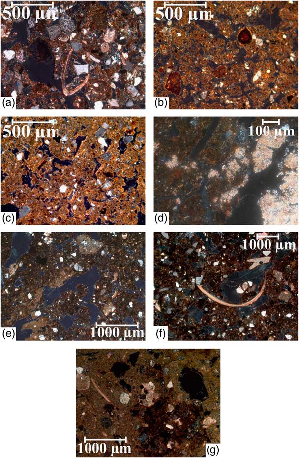
The general microstructure of all the layers under study is displayed in Figure 6. When considered in succession, the gradual changes in the layer structure are well traceable: the upper layers (I and II) present granular structure, coprogenic, with distinct traces of mezofauna activities (Fig. 6a and b); downward the structure is coarser and the soil mass becomes more compact and closely packed, though individual granular aggregates are still visible and traces of faunal activities are discernible in layers III and IV (Fig. 6c and d). Cultural layers V and VI are noted for a drastic change in structure: the soil mass is broken into blocks outlined with regular (subparallel) fissures and cracks (Fig. 6e and f). Layer VII is completely structureless and Fe-Mn dark spots are well-pronounced (Fig. 6g).
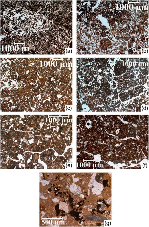
Figure 6 (color online) The microstructure of the studied layers in the Tr1b-15 sequence. See the text for explanations. All the photographs were taken with plane polarized light (PPL) at the same magnification, except for (e) and (g).
The elements of structure, and first of all carbonate features, when considered in detail, reveal specific characteristics giving an insight into the cause of conflicting data obtained from the studies of the layer composition (see above). The fine matter in layer I is clayey-ferruginous in composition, with carbonate accumulations found in pores, voids, and present as micrite concentrations around pores, or as undifferentiated nodules. Occasional presence of shell fragments of presumably aquatic mollusks (Fig. 7a) suggests the river periodically flooded the layer. Soil fine material in layers II and III is clayey-ferriferous in composition, weakly anisotropic, optically oriented around skeletal particles, and mottled with spots of iron compounds and small-size Fe nodules (Fig. 7b and c). Such microstructure is typical of medium (not superficial) horizons of Meadow Chernozems (Stagnic Chernozems) with sufficient water supply; usually such soils develop under conditions of a leaching water regime. Carbonates are completely absent from layer II, while in the lower layer (III) they are found in a small proportion as limestone fragments in pores. The calcareous material of the fragments is recrystallized, which agrees well with meadow type of soil formation easily identifiable from the morphology and composition of the two layers.

Figure 7 (color online) Elements of microstructure of the studied layers in the Tr1b-15 sequence. See the text for explanations. All the photographs were taken with cross polarized light (XPL).
Considering microstructures of the lower lying layers IV, V, VI (Fig. 7d–f), the microstructure is noted for much darker color as compared with the three others considered above. The fine materials in layers IV, V, and VI is clayey-calcareous, so that carbonates are present in abundance. The carbonates with clay are overlain with clayey-ferruginous material, as particularly clear in Figures 7d and e. When viewed in reflected light, the samples show the presence of organic matter and manganese, besides Fe and clay, in the overlying material. Some fragments of calcareous shells are also quite distinct in the overlying material (Fig. 7e and f). Evidently, that was a case of two-phase formation of the fine material in the layers under consideration: the initial clayey-calcareous material was later overlain with ferruginous-clayey matter with organics and manganese admixture. The presence of mollusk shells suggests fluvial deposits taking part in the overlying material formation.
The microstructure of layer VII does not reveal any signs of soil formation; diversified carbonate features, from recrystallized calcareous rubble to cryptocrystalline nodules in fine material and large fragments of shells (Fig. 7g), are conspicuous. The mineral skeleton of the layer is quite different from the overlying layers in both composition and the size of fragments. That is indirect evidence that the Permian red rocks noted for a high content of carbonates took an active part in the formation of that layer.
Microbiomorpic analysis
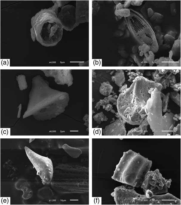
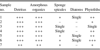
The microbiomorphic analysis revealed a great amount of plant detritus and amorphous organics present practically in all the layers (except for the lowermost layer VII, where its proportion is slightly lower); sponge spicules (Fig. 8a) are also present in abundance (Table 1). Cultural layers V and VI differ from the other layers by the greatest proportion of charred wood detritus. The spicules recovered from the layers have no signs of corrosion and their canals are not filled with mud, so they have not been redeposited and their deposition was apparently synchronous to the formation of the layers. Similar, undamaged spicules are present, though in smaller amounts, in layers I and VII. Samples from layers III and IV yielded spicules only occasionally, the latter being partially destroyed, with canals well-silted with redeposited older sediments. In addition to spicules, the samples contained diatom frustules (Fig. 8b). It is of interest that the diatom distribution is close to that of spicules: diatoms are found in those samples only where the spicules seem to be well-preserved (like those in layers I, V, and VI). The best-preserved diatom frustules were recovered from the uppermost sample.

Figure 8 Different forms of silica microbiomorphs: (a) sponge spicula; (b) diatom; (c) phytolith of stipa grasses; (d) phytolith of reed; (e) phytolith of meadow grasses; and (f) phytolith of coniferous.
Table 1 Comparative semi-quantitative contents of microbiomorphs. Estimated content of the microbiomorphs: +++, high; ++, medium; +, low.
The greatest number of phytoliths was recorded in layer VI (Table 2). The sample taken from the layer differs conspicuously in phytolith abundance from adjacent samples. It may be suggested that the layer richest in phytoliths is a result of superposition of the cultural layer characteristics on the alluvial deposits. Another possible explanation is that a human dwelling existed there with various herb and grasses, or probably reed, used in its construction.
Table 2 Distribution of siliceous microbiomorphs (counted/%) and diagnostic groups of phytoliths (%). Numbers 1 to 6 designate the diagnostic groups of phytoliths as follows: 1, herbs; 2, coniferous needles; 3, forest grasses; 4, meadow grasses; 5, steppe grasses (mostly Stipa sp.); 6, reed and sedges.
a Number per gram (millions).
b Particles found in amounts less than 1% of the total.
The number of phytoliths in layers V and IV is much less (almost by an order of magnitude) than in layer VI. It is only in samples from those three layers that the presence of steppe gramineous plants (Fig. 8c) together with reed (Fig. 8d) and sedge phytoliths was recorded, along with a considerable proportion of meadow grasses (Fig. 8e).
The samples with minimum number of phytoliths (layers II and III) are also noted for the absence of diatoms and a scarcity of sponge spicules. It may be assumed that those layers resulted from the movement of sediments on the slope, phytoliths being probably involved in the movement only occasionally. It is also possible that originally those layers did not occur on the surface and were exposed after the overlying layers had been removed by erosion. Layer I also features an abundance of phytoliths, their assortment is close to that in the cultural layers. A distinguishing feature of layer I is the presence of coniferous phytoliths (besides that layer, coniferous phytoliths [Fig. 8 f] were found only in layer VII, their abundance being there ever greater); those of reed or sedge are completely absent.
Phytolith assemblages recovered from fluvial sediments or from deposits of slope wash or those of intermittent streams provide information on the regional vegetation. As follows from those data, the region was dominated by forest and meadow coenoses at all times; small amounts of steppe grass phytoliths were found in layers IV, V, and VI only.
Pollen analysis, comparison with data obtained from microbiomorpic analysis
Pollen analysis was performed on the Turganik site by Spiridonova (Lavrushin and Spiridonova, Reference Lavrushin and Spiridonova1995) during the first excavation of the settlement. The radiocarbon ages were widely used when interpreting the pollen assemblages. In case a particular layer had not been dated by radiocarbon, its age was conjectured on the basis of geological and paleogeographic correlations. To give one example, layer VII, extremely deficient in pollen and spores and composed mostly of solid rock fragments, was tentatively dated by the authors to the final stage of the late glacial (Younger Dryas). After that, the processes of erosion and denudation were dominant. Much later, at the second part of the Atlantic period of the Holocene (as was confirmed by radiocarbon dating of archeological materials), the pollen assemblages suggest steppe vegetation of herbs and grasses, or purely grass steppe, with small amount of pine. This conclusion agrees with the data on phytoliths and with the xeromorphic properties of paleosols dated to that time (the earlier phase of the layer VI deposition).
Pollen assemblages of the Atlantic optimum ~5500 yr BP indicate some increase in moisture supply and related afforestation of the floodplain (Lavrushin and Spiridonova, Reference Lavrushin and Spiridonova1995). As follows from our data, the site was abandoned at that time and the no-longer-functioning cultural layer VI was gradually buried under deposits of frequent floods. According to the 14C ages obtained on archeological materials, the age of layer VI (or the second stage of the Eneolithic epoch on the Turganik settlement) may be dated to 4237–3790 cal yr BC, that is, somewhat earlier than the Holocene optimum suggested by palynologists.
Layer V shows another interval marked by increasing climate aridity and the dominance of grass steppes. As stated by the above-cited authors, the climate at the time that layer V was functioning was even dryer than during the formation of layer VI. That is confirmed by our data on the layer V composition, was formed during early Pit-Grave culture (the Early Bronze Age), in the range from 3800–3360 BC, according to the dates obtained on archeological materials (Morgunova et al., Reference Morgunova, Turetskii, Kulkova and Nesterova2016b). As follows from the above, the maximum of aridity coincided with the Atlantic optimum. The above-cited authors (Lavrushin and Spiridonova, Reference Lavrushin and Spiridonova1995) obtained the age of 4250 ± 200 14C yr BP on humus from layer V; that date may be taken as the end of the functioning of the layer and the beginning of its burial under later deposits.
Later on, in the Subboreal interval, the authors noted a cooling, development of meadow-chernozem soils or Luvic Chernozems (Stagnic; IUSS Working Group WRB, 2014), and proportion of arboreal pollen in the assemblages rising up to 40%. Quite possibly, it was at that time that layers IV, III, and II formed. The humus horizons of the soils, however, developed at that time could be completely destroyed by wind erosion activated during dry intervals.
Finally, there are interlayers in layer I indicative of a drastic increase in aridity that probably took place in the Middle Ages; occasional fragments of medieval pottery have been recovered from the layer where pollen assemblages are dominated by Chenopodiaceae with Artemisia and grasses, with some sedge pollen near the top of the layer. Most likely, the layer I formation was a complicated process, as might be inferred from its composition as well as from pollen and spore assemblages.
On the whole, there is certain compatibility between the data obtained from the phytolith analysis and those from pollen assemblages; both strongly suggest the dominance of open landscapes (indicated by prevalence of meadow plant communities) through the entire period of the deposition. Varying relation between tree species and steppe (dry steppe) grasses may be interpreted in terms of the climate aridity and humidity. Each of the considered methods provides additional information on the landscapes and vegetation, in particular, that existed at the time of the deposition, functioning, and burial of the layers under study.
DISCUSSION
The analysis of the geologic and geomorphic context of the Turganik settlement performed during its initial excavations led Yu.A. Lavrushin to the conclusion on the deluvial-proluvial character of its deposits, despite the fact that the settlement is located near the riverbed of the Тоk River (Lavrushin and Spiridonova, Reference Lavrushin and Spiridonova1995). The archeological objects are enclosed into an apron composed of materials brought by sheetwash or ephemeral streams from the adjacent elevated surfaces to the base of the valley side. Deposits of the settlement may be a source of information on environments during the entire period of the accumulation of sediments. We focused our attention precisely on the processes of sediment accumulation together with the environments of accumulation, considering the morphology and composition of the layers in the Tr1b-15 section on the Turganik settlement.
Clear signs of human activities are found in two out of seven layers of the studied section; those are layers V and VI, noted for increased contents of total phosphorus as compared with the background values. Only those units may be considered as cultural layers bearing strong evidence of human permanent habitation, not just of a short-time stay. In case of a short-term human stay, some artefacts could be probably found, but changes in the chemical composition of deposits (an increased content of phosphorus) are highly improbable.
Among distinctive features of the morphology of cultural layers are: a whitish hue clearly pronounced in the deposit color, a high carbonate content, clayey composition, and columnar or nutty-columnar structure (Table 3). The cultural layers display an abundance of carbonates and gypsum, the greatest proportion of fine fractions (<0.001 and <0.01 mm) in their granulometric composition, the dominance of Mg in the exchangeable bases, and the highest values of pH, while geochemical coefficients of weathering are relatively low. Only those cultural layers indicate the presence of readily dissolved salts. Of course, such properties as alkalization and carbonatization may be partly attributed to the results of human activity. That was noted, for instance, in the soils of antique cities in comparison with virgin natural soils (Alexandrovskiy et al., Reference Aleksandrovskiy, Aleksandrovskaya, Dolgikh, Zamotaev and Kurbatova2015). But the whole set of the listed characteristics can be conditional on natural processes only and suggests highly arid environments at the time of accumulation of those layers and transformation by soil-forming processes. The soils formed at that time were probably of chestnut type (or Kastanozems [Endosalic Protosodic]; IUSS Working Group WRB, 2014), bearing distinct traces of salinization and solonetzicity. These conclusions are supported by the data on phytoliths and pollen assemblages, the latter being clearly indicative of the dominance of grass and herb steppes at the time of functioning of the cultural layer.
Table 3 The age of the layers, main indices of soil processes, pollen and phytolith assemblages, and paleoclimatic reconstruction.

At the same time, the cultural layers under consideration feature high contents of Corg, along with high values of geochemical coefficients of bioactivity and bioproductivity of the ecosystems, as well as magnetic susceptibility. As follows from the micromorphological studies, the fine material rich in Fe, Mn, organic matter, and shell fragments overlies and conceals the clayey-calcareous material. The phytolith assemblages recovered from the layers include sponge spicules and diatom frustules.
The observed characteristics of the microstructure and composition of layers V and VI (cultural layers) may be interpreted as follows. The layers were supposedly formed in the course of prolonged and quiet stages of the slow sedimentation, the deposits being gradually changed by processes of the arid soil formation. Every stage of the deposition ended with an episode of catastrophic floods that left the poorly sorted overlying material. Those episodes were short when compared with long-lasting period of the site (or settlement) existence near the quietly flowing river, where floods did not occur even in spring. That accounts for an apparent contradiction in the composition of cultural layers V and VI: on one hand, they contain carbonates and gypsum, readily soluble salts, exchangeable Na and Mg, and, on the other, iron compounds (including magnetic ferriferous minerals), manganese, and organic carbon. So, the long-lasting dry periods when cultural layers developed and were functioning came to an end with catastrophic floods that could force ancient people to leave the habitable area. The floods were probably high-energy but short-term: they left only limited amounts of non-sorted material enriched in the above-listed constituents and could not completely conceal traces of arid soil-forming processes.
The aforementioned interpretation is supported by the diversity of phytolith assemblages retrieved from the cultural layers. These assemblages contain phytoliths of forest, meadow, and steppe grasses on one hand and indicators of aqueous environments of deposition (such as sponge spicules, diatoms, reed, and sedges) on the other. The main body of a cultural layer could be formed in comparatively arid environments but, at the final stages, the river water bringing minor amounts of alluvial material flooded the site. The earliest stages of the sequence formation were marked by the presence of coniferous trees in the vegetation, which seem to be gradually restored at present.
Layer IV, dated to the final Atlantic-early Subboreal periods of the Holocene, is similar to the cultural layers (V and VI) in its composition and assortment of phytoliths. This means that the processes of accumulation and transformation of materials in layer IV were largely similar to those in the older cultural units. A more thorough analysis of layer IV, however, revealed signs of a long-lasting increase in humidity since the Subboreal period. When compared with layers V–VI, layer IV is noted for a less distinct columnar structure and a less pronounced whitish (grayish) hue in its color. Traces of mesofauna activities are more noticeable in micromorphology and granular aggregates appear. The Corg accumulation prevails markedly over that of Ccarb, while the pH of water extract and gypsum content are lower. Layer IV is also noted for a higher proportion of exchangeable Ca in the exchangeable bases, as well as for greater indices of weathering and lower rate of carbonate accumulation and salinity. The coefficients of biological activity and bioproductivity as well as the value of magnetic susceptibility are the highest in this layer (Table 3).
For reconstruction of environments at the second half of the Holocene recorded in the studied layers, most important is a dramatic change in the soil formation process after the formation of layer IV had been completed. Unlike the lower ones, layers II and III display characteristics of humid soil formation: they are devoid of carbonates, gypsum, and easily soluble salts, Corg content is rather high, and the exchangeable bases differ from the above in that Mg is completely absent or present in negligible amounts. Those layers show well-pronounced signs of biological activities and soil aggregation: granular structure is clearly discernible in macro- and micromorphology and the iron-clayey carbonate-free fine material bears characteristics of mobility and anisotropy. All those features are evidence of humid soil formation of the meadow-chernozem type (or Luvic Chernozems [Stagnic]; IUSS Working Group WRB, 2014) in the case under consideration. Frequent floods regularly occurring since then made the high floodplain surface unfit for habitation.
Layer I seemingly developed at the time of the surrounding area being actively used as arable land. The tilling caused accelerated erosion. The layer composition gives an integrated picture of the modern background soils resulting from mixing of the upper humus horizons with the underlying calcareous ones. Layer I is noted for the lightest gray color (Table 3). As follows from the palynological data, the lower interlayers within the layer contain information on a short interval of increased aridity marked by Chenopodiaceae pollen dominance (with sagebrush and grasses as codominants), replaced by sedges in the upper part of the layer.
It follows from the above that the Atlantic period of the Holocene was mostly characterized by arid environments; the peak of aridity fell on the early Bronze Age, the time of the early (Repino) stage of the Yamnaya culture in the Cis-Ural steppes. The Subboreal and Subatlantic periods were relatively colder and more humid, though short episodes of aridity could occur and some of them happened to be recorded in the sequence under study.
The reconstructed history of the climate changes in the Cis-Ural steppes during three intervals of the Holocene is in a good agreement with the results obtained in other regions. According to Alexandrovskiy (1996, Reference Alexandrovskiy2000; Alexandrovskiy et al., Reference Alexandrovsky, Sedov and Golyeva1999, Reference Alexandrovskiy, Glasko, Krenke and Chichagova2004), the Atlantic period was the most arid one in the south of Russia, the subsequent intervals being comparatively wetter and colder. The extreme aridity was recorded on the Ukraine territory at the final Atlantic period, a few less arid chrono-intervals having been identified over the entire period (Kotova, Reference Kotova2009). There are, however, other schemes of climate fluctuations in the central part of the Russian steppe zone; a few of them consider the Atlantic period to be humid, or even the most humid, as compared with the second half of the Holocene (Ivanov, Reference Ivanov1992; Demkin, Reference Demkin1997). Also acceptable is a scenario of climatic fluctuations occurring at different times in different regions (Chendev et al., Reference Chendev, Ivanov and Pesochina2010). Further investigations and accumulation of empirical data would help to gain a better insight into the problem.
CONCLUSION
The studies of the multi-layered settlement Turganik (Cis-Ural steppe region) permitted the development of a scheme of climatic fluctuations and changes in regional vegetation for the second half of the Holocene (beginning from the Atlantic); the scheme is based on the data on paleosols and phytolith analysis, some earlier publications on pollen assemblages also being widely used.
The ancient people inhabited the place from 5000 to 4000 BC (actually throughout the Atlantic period), when the place was not subjected to flooding. At the time of human habitation, the climate was mostly arid. Paleosols of that time are attributable to the Kastanozems (Endosalic Protosodic). They developed under grass (or herb and grass) steppes. The peak of aridity falls on the final Atlantic period. At the end of Eneolithic epoch (the fifth millennium BC) and in the Early Bronze Age (the fourth millennium BC) there were short-term but violent floods, which forced people to leave the habitable place.
During the Subboreal and Subatlantic periods of the Holocene, the climate became more humid, the floods became regular, the vegetation was dominated by meadow forbs and herbs growing on meadow-chernozem soils (Luvic Chernozem [Stagnic]), and the settlement was completely abandoned. In general, the studied sedimentary record at the Turganik archeological site reveals traceable climate change towards lower temperatures and increasing humidity in the second part of the Holocene, with occasional episodes of aridity that did not affect the general trend.
ACKNOWLEDGMENTS
The archeological excavations and dating were performed with the financial support from the Department of Education and Science RF, Project No 33.1389.2017. The paleosol investigations were funded by the RSF, Project No 16-17-10280; the works on phytolith analysis had supported from the RSF Project No 14-27-00133. We also thank two anonymous reviewers for their constructive criticism of the manuscript and their valuable suggestions.