
A revisionist view of urban fortunes in post-Black Death England has emerged. Rather than a picture of ‘decline’, urban historians instead see evidence for resilience in towns and cities of the late fourteenth and fifteenth centuries, where some places gained in population, through in-migration and investment, while others waned.Footnote 1 As Britnell observed, although the overall population declined after 1350, and was lower in 1500 than it had been two centuries earlier, ‘there is no reason to suppose that the urban proportion was reduced’.Footnote 2 Moreover, urban wealth generally increased at the expense of rural wealth in England during the later Middle Ages.Footnote 3 This trend is reinforced by contemporary accounts, such as John Leland's Itineraries, as well as by localized and regional cases of urban prosperity in the two centuries after the Black Death.Footnote 4
There was, it seems, an uneven geography to urban decline in later medieval England.Footnote 5 However, despite a more critical and nuanced view of urban decline, the idea that urban planning ceased in post-Black Death England, and the formation of new urban landscapes stopped during the later Middle Ages, nevertheless persists. The picture presented of built environments in this period remains typically one of ‘decay’, not planning and development. According to Platt, for example, ‘empty plots and ruined tenements blighted most fifteenth century townscapes’, and English urban landscapes after 1350 shrank in extent as the areas that had been added to towns and cities in earlier more prosperous times were abandoned.Footnote 6
This view, that the Black Death marked the end of urban planning schemes in medieval England, owes much to the long-lasting legacy of Beresford's New Towns of the Middle Ages.Footnote 7 Here, Beresford had marshalled documentary evidence that seemed to show that the foundation of towns in England peaked in the 1220s but subsequently tailed off dramatically in the fourteenth century. According to his assessment, following the founding of Queenborough on the Isle of Sheppey (Kent) by Edward III in 1368, the ‘plantation of towns ceased for nearly three hundred years’, and ‘when it was revived by James I and the London Corporation it was for the soil of Ulster not England’.Footnote 8
Urban planning in the Middle Ages encompassed more than just founding ‘new towns’, however, as detailed urban morphological studies of particular towns and cities have shown.Footnote 9 It included the redevelopment and renewal of existing urban landscapes – what M.R.G. Conzen described as ‘augmentative’ development – as well as distinct phases of urban expansion and extension – through processes of ‘additive’ development – described by urban morphologists as ‘plan-units’.Footnote 10 Moreover, urban planning is not solely revealed by the presence of regularities in plan-form, as Conzen noted.Footnote 11 With this greater complexity in mind, there is reason to look again at the period considered by many to be one characterized by urban decay rather than planning and development, to see what evidence there is for the transformation of townscapes during the later fourteenth and fifteenth centuries, and consider urban planning in England after the Black Death from a morphological perspective.
A reappraisal of post-Black Death urban planning has significance that goes beyond English urban history and historiographies, for it also offers scope to reconsider the contrast often drawn between England's urban experience and that of continental Europe. In particular, those standard textbook accounts of European urban history, such as Morris’ History of Urban Form, and Hohenberg and Hollen Lees's Making of Urban Europe, promote an impression that while through the period 1350–1550 Europe witnessed an ‘urban renaissance’, England's urbanism, on the other hand, languished during these ‘un-urban centuries’, as Beresford once described them.Footnote 12 On this basis, the lack of any new towns – or indeed urban planning – for two centuries following the Black Death, seemingly stands in stark contrast to the situation described elsewhere for Europe at this time, in France, Italy and Spain, for example. Here, idealized and geometrically ordered plans for new towns and cities, such as those by Francesco di Giorgio Martini and Antonio di Pietro Averlino of the fifteenth century, are used as exemplars to point not only to new forms of urbanism but also new modes of cartographic representation.Footnote 13 Sometimes, these plans were realized on the ground, sometimes not.
Either way, this symbiotic and symbolic linkage forged between map-making and planning, between map-makers and urban planners, is seen by historians to reflect a tangible divide between the urban experience of (‘medieval’) northern Europe, after 1350, compared to that of the (‘Renaissance’) south.Footnote 14 Here again, then, some reconsideration of the English evidence seems overdue, not least because England in the later Middle Ages, and its towns and cities, had close connections with European counterparts, providing potential for urban prosperity of course, as well as having implications for English urban planning and development.
To look afresh at English urban planning after the Black Death, this article seeks to re-examine the nature and character of planning itself, asking ‘what is it to plan?’ To explore this, the aim is to go beyond the usual conventions used by archaeologists and historians where, following Beresford, ‘new towns’ are typically seen as evidence of ‘ideas of what may be termed medieval town-planning’.Footnote 15 This has become a standard model used to define medieval urban planning, the origin of which is to be traced beyond Beresford's New Towns, to the early twentieth century and works such as Hughes and Lamborn's (1923) Towns and Town Planning: Ancient and Modern, Tout's (1934) Mediaeval Town Planning, as well as contemporary English architect-planners, such as Patrick Abercrombie and Raymond Unwin.Footnote 16 This is a rather restricted view of what constituted medieval urban planning, so what is offered in the discussion that follows is a broadening out of ‘planning’ as a process, encompassing the foundation of new towns, yes, but also other forms of urban development and redevelopment.
By focusing on some examples drawn from England after 1350, a case is made not only for recognizing continuities occurring in urban planning across the fourteenth, fifteenth and into the sixteenth centuries, but also that the characteristics of planning ought to be defined more broadly to include ‘augmentative’ as well as ‘additive’ types of urban development. In so doing, the article seeks to show that while conventional kinds of planning acts can be identified in this period, such as the foundation of new towns, there were other post-Black Death transformations taking place in townscapes in English towns and cities. Such redevelopment schemes and improvements similarly constituted acts of urban planning, often centrally led by civic, aristocratic or royal authorities. To this end, the article first considers evidence for the continued creation of ‘new towns’ and suburbs, additive in nature, and the morphological character these took, before, then, secondly, focusing on augmentative redevelopment such as ‘civic improvement’, and how this can reveal other forms of urban planning in the later Middle Ages as well as those involved in the planning processes.
Urban planning and the ‘new towns’ of the later Middle Ages?
Beresford's statement, that ‘after Queenborough in 1368 there is no certain evidence for a new town [in England] until the creation of Falmouth in 1613’, seems unequivocal.Footnote 17 With its broadened market street leading up to the castle-gates, Queenborough's layout seems to fit into an earlier tradition of new towns, such as those ‘castle-towns’ founded by Edward III's grandfather in Wales some 60 years earlier.Footnote 18 A case can be made, however, to see Queenborough not as the end of a line of medieval new towns but as one of the first post-Black Death examples, so representing continuity in the formation of new towns in later medieval England. Another of these urban successors was Bewdley in Worcestershire, a county Beresford had glossed over in his otherwise extensive gazetteer in New Towns of the Middle Ages, commenting that ‘no medieval plantations have been found in this county’.Footnote 19 However, following the morphological approaches established by Conzen, in a careful study of the ‘composite plans’ of medieval new towns in the Midlands that includes Bewdley, Slater provides not just an interesting and important corrective to Beresford's gazetteer, but evidence too that towns were being founded in England in the later fourteenth and fifteenth centuries.Footnote 20
The origins of Bewdley were commented upon by John Leland in his Itinerary: ‘of old tyme there was but some pore hamelet’, he wrote, ‘and that apon the buildinge of a bridge there apon the Severn, and the resorte of people onto it, and comoditye of the pleasaunt site, men began to inhabite there’.Footnote 21 The sequence of urban development at Bewdley as mapped by Slater shows the earlier focus of the town was on higher ground away from the Severn, close to the park belonging to Philippa de Montagu (1332–81), countess of March, who founded this ‘street borough’, as Slater puts it, by the later fourteenth century, following the death of her husband, Roger de Mortimer.Footnote 22 Subsequently, in 1446, a market charter is granted and in 1472 a grant is made by King Edward IV to the burgesses and inhabitants of Bewdley whereby ‘the town with its precinct shall be a free borough.Footnote 23 Coupled ‘with the building of a new bridge over the Severn, in 1447’, Slater surmises, ‘a developing river trade moved the economic emphasis to the riverside and, by 1472, all the main streets of the modern town are recorded in documents’.Footnote 24
The morphological sequence at Bewdley reveals stages of development from the late fourteenth century and through the fifteenth (Figure 1). ‘Additive’ in nature, to use Conzen's terminology, each phase of development is evident as distinct plan-units (as defined by Slater) observable in the town's plan. Some of these plan-units are regular in layout, while others are not, the whole ‘new town’ being ‘composite’ in form. In this respect, Bewdley is just like those new towns founded in earlier times, before the Black Death, during the eleventh, twelfth and thirteenth centuries, which also share composite plans reflecting similar processes of additive development and phased planning.Footnote 25

Figure 1 The composite plan of late medieval Bewdley (Worcestershire) showing the areas developed in the fifteenth century (plan-units III, IV, V and VI), from T.R. Slater, ‘English medieval new towns with composite plans: evidence from the Midlands’, in T.R. Slater (ed.), The Built Form of Western Cities (Leicester, 1990) (reproduced by permission of T.R. Slater).
Bewdley is no isolated case. In this same ‘sterile period’, as Beresford characterizes the two centuries after the foundation of Queenborough, another new town was established, also in the English Midlands, further to the north from Bewdley. This was Sutton Coldfield, where early in the sixteenth century, in 1528, John Harman (Vesey), bishop of Exeter, ‘induced’ King Henry VIII ‘to incorporate the inhabitants, by the name of the Warden and Society of the Royal Town of Sutton Coldfield, and grant them his town, manor, or lordship, free chase and park of Sutton Coldfield at an annual farm of £58’.Footnote 26 As part of this new initiative, Harman ‘laid out the market place’ and ‘erected 51 stone houses’ there, clearly demarcating the old Sutton from the new.Footnote 27 Again, the temptation might be to see Harman's guiding hand here but the king's surveyors were at Sutton at this time too, dividing up parts of the adjacent park and chase for the king, a sign that there were others on the spot who had the necessary expertise to assist Harman in the process of laying out a new market place and siting new houses for creating the new ‘royal town’ of Sutton. Although there are no contemporary plans showing Harman's urban venture, elsewhere similar newly designed settlements, contemporary with Sutton, were being mapped by Henry VIII's surveyors, not in England but in northern France, such as the surveyed plan made for laying out a projected settlement near Calais, in 1541.Footnote 28
As examples, Queenborough (1368), Bewdley (1446–47) and Sutton Coldfield (1528) reflect a continuing tradition of urban planning spanning the period 1350–1530. They indicate how creating new towns remained a feature of England's economic and political landscape after the Black Death. As well as ‘new towns’ persisting across the fourteenth century, there were also existing towns and cities at this time that saw the addition of new suburban areas, as a further Midlands example demonstrates.
Using part of the park of Cheylesmore manor, a new suburb was planned for the southern fringes of Coventry. This further reveals the role played by landholders in shaping urban landscapes, though again not without local support. The process began with a block of land comprising 88 roods, granted by Queen Isabella to 88 prominent Coventry citizens and confirmed a year later in an inspeximus of Edward III in 1348.Footnote 29 Scholars working on medieval Coventry have variously attempted to locate this apparent act of royal urban planning.Footnote 30 Recently, it has been suggested that the block of land mentioned in the charters lay in an area of the park known as Little Park, but that the whole scheme was quickly abandoned, apparently due to the impact of the Black Death on the city. Footnote 31 The intended new streets and associated plots were left undeveloped it seems (Figure 2).
Figure 2 The suggested layout of the mid-fourteenth-century new suburb of Queen Street, Coventry (Warwickshire), situated to the south of the built-up area and beyond the town walls in Cheylesmore Park, from N.W. Alcock, ‘Queen Isabella's new suburb in 1348’, Midland History, 33 (2008), 240–8 (reproduced by permission of N. Alcock).
At first, it might appear that Isabella's new extra-mural suburb in Coventry, named Le Quene-strete in her honour, was a case of bad timing, a failure on the grounds that a post-Black Death city surely contracted in population rather than expanded? This view fits the conventional picture presented of urban decay in the later fourteenth and fifteenth centuries, a contraction of suburbs not expansion. Yet, as Phythian Adams has shown, Coventry's economy bucked the trend among many English towns and cities in this period, and positively prospered because of its cloth production, such that by 1377 Coventry ranked fourth in its taxpaying population, after London, York and Bristol.Footnote 32 With local prosperity and rising population, a new suburb created under royal patronage in a location close to one of the city's most important thoroughfares surely stood a reasonable chance of success? Perhaps, instead, its early demise as a suburb was due to preferences of local townsfolk wishing to remain within the circuit of walls (then being built), and closer to the civic and mercantile core of the city. Whatever the reasons for the failure of this ‘infant town planning enterprise’ in Coventry, it demonstrates a desire to plan and build for the future at a time when the future must have looked increasingly bleak.Footnote 33
Applying Conzen's approach, a more complex morphological and historical pattern of urban planning and development emerges. Distinct phases of additive growth are revealed, sometimes regular in their form, sometimes not. This makes any distinction between ‘new towns’ and ‘organic towns’ overly simplistic, as Conzen himself contended: ‘careful study of individual cases and of groups of medieval towns in various parts of Europe has rather discredited the opposition of “irregular” versus “regular” plans and the unhistorical equation of these with spontaneously-grown [i.e. ‘organic’] and “planned” towns’.Footnote 34 As the examples of late medieval Bewdley and Coventry both show, ‘urban planning’ can take many forms, resulting in irregular or regular layouts on the ground, and these forms of planning persisted both during and after the years of the Black Death in England. Further work may well reveal similar cases elsewhere, beyond the examples of towns from the Midlands identified here.Footnote 35
As well as questioning ‘what is it to plan?’, and undermining models of urban planning based simply upon regularities in form, urban morphologists following Conzen's approach have drawn attention to the roles played by ‘agents of change’ in shaping medieval towns and cities.Footnote 36 To examine this, the article turns to consider ‘augmentative’ forms of development in urban landscapes of the post-Black Death period, and the planning processes and ‘planners’ involved. Spanning various urban improvement schemes and civic projects of the fourteenth and fifteenth centuries, including planning new defences, roads and waterways, a sample of different forms of urban planning provides evidence on the role of individuals, or ‘agents of change’, acting as urban ‘planners’, including surveyors, masons, patrons and officials. Through their activities in transforming townscapes certain parallels can be drawn between the changes taking place in English towns and cities after 1350 and those seen in continental Europe at this time.
‘Agents of change’ and the planning process
From the smallest of boroughs to the largest of cities, contemporary accounts reveal details of certain ‘agents of change’ whose expertise was sourced and funded by local authorities to assist in the planning process. At Norwich, for example, extracts from the city treasurer's accounts after the Black Death yield evidence that outside assistance was sought. Leading up to the appointment of a mayor in the city in 1404, the late fourteenth century in Norwich sees a series of interlinked corporate projects of improvements and public works being initiated by local officials.Footnote 37 There is an account in 1399 of ‘one man coming from [King’s] Lynn to examine the defects of the Common River’, presumably acting to advise the municipality on what could be done to the Wensum to improve the situation, at a cost of 6s 8d.Footnote 38 Two years later, in 1401–02, this initial survey was followed up, as a certain William Fulkes was sent to Colchester in order ‘to consult there with a man called Blaumester’.Footnote 39 This name probably indicates his Flemish origins; bouwmeester, an architect or master mason, someone with particular competence in matters of construction, planning and design. Blaumester must have appeared knowledgeable (or convincing) for in the same year he was brought up to Norwich and paid 20s ‘for examining the place for the water mills to be newly built’.Footnote 40
It was in the interests of medieval urban governments to be involved with planning and development, for the wealth and vitality of a town or city was outwardly reflected in its buildings and streets, and in its civic programmes and improvement schemes. While such schemes existed in England in the thirteenth century, as at Bristol for example, more numerous accounts of expenditure and administration concerning various townscape initiatives and improvements appear in later municipal and state records, in the fourteenth and fifteenth centuries.Footnote 41 As well as seeking to undertake self-improvement, those urban governments engaged in townscape transformations at this time were also meeting demands placed by the crown and this too required careful planning and negotiation between different parties. A case in point concerns the impetus to bolster defences of coastal towns and cities of England to defend them from French attack during the Hundred Years War.Footnote 42
From the 1360s onwards, substantive new building projects were undertaken along the south coast of England in improving urban defences. A number of port towns where this occurred, such as Winchelsea, Southampton and Portsmouth, reveal how planning and surveying played an important role in shaping new urban infrastructure. At Winchelsea, for example, a royal commission was set up in 1414, and an inquisition held in 1415, regarding ‘the proposal of the mayor and commonalty of Winchelsea for enclosing the town. . .making it of a lesser circuit than the present site of the town because that site is now too large for the inhabitants’.Footnote 43 In making their proposal, the line for the new defences (for which ‘five yards are needed’) was set out and reported, street by street, house by house, including which properties would be affected by the work and what land would be required. This survey was used for planning the town's defences therefore, before the alignments were dug. How much the new circuit enclosed the shrunken built-up area of the town, just as the mayor and commonalty had first proposed, can be seen from a map of the defensive circuit drawn by David Martin (Figure 3).Footnote 44 Through the commission and inquisition, and surviving archaeology, some sense of the planning process – and those involved – is revealed by the construction of Winchelsea's new defences in 1415. This was achieved through a process of negotiation, where surveying was the key not only to recording what was on the ground but also setting out what was planned.
Figure 3 The L-shaped alignment of the 1415 defences at New Winchelsea (Sussex) encompassing the shrunken core of the town, from D. Martin and B. Martin, New Winchelsea Sussex. A medieval port town (London, 2004) (reproduced by permission of D. Martin).
Winchelsea had by this time suffered from decline, yet still its harbour was of particular importance to the crown, hence the investment made in upgrading its urban defences.Footnote 45 The role of surveying in townscape transformations in the fifteenth century is further revealed in similar works carried out further along the south coast at larger and more prosperous towns, such as Portsmouth and Southampton. Again, this required the appointment of surveyors. Numerous writs and commissions of this period make mention of surveyors and surveying in the context of planning new works, such as the writ de intendendo ‘directed to the Sheriff of Southampton and others of that county’ in 1386 to appoint certain men ‘to survey Portsmouth and take order for its defence against. . .invasion’.Footnote 46 A similar writ was served on Henry Peverell, keeper of the town of Southampton, in 1360, ‘to inquire as to the obstruction of the defence of the town by porches and gardens adjoining the wall’.Footnote 47 Here, as a consequence, a detailed inquisition was undertaken by three juries who made recommendations for ‘a common way’ to be ‘made within the walls and enclosures of the town of the width of twelve royal feet’, requiring ‘every man having gardens within the town’ (adjoining the walls) to clear them, and those outside the walls to be ‘destroyed from the town ditch to the ditch of the Saltemarch’.Footnote 48 These improvements included adding garites (sentry boxes) to the walls, and also ‘a cutting. . .to the town ditch so that running water may have its way to the ditch’, all of which must have required careful survey, as well as negotiations on the part of the keeper, Henry Peverell. Things did not go well on this account, and Peverell reported back to the crown that ‘the people of the town are very angry because of what has been pulled down’, and proposed, ‘if it please you, discharge me of this office and appoint others in my place as I can no longer endure the labour’.Footnote 49
Urban planning can be usefully conceptualized as a process, therefore, involving a range of individuals, potentially, from land-holders, to civic officials, to paid experts and so on; each of whom had an input into decision-making.Footnote 50 Details about such individuals are often rather better documented in the later Middle Ages in England than they are for earlier periods, providing an opportunity to establish more clearly who was involved in particular civic planning schemes. A case in point concerns London, where evidence for surveys and plans in shaping new urban developments are to be found well before the city had set its sight on ‘the soil of Ulster’, as Beresford had put it, in founding Londonderry in 1613.Footnote 51
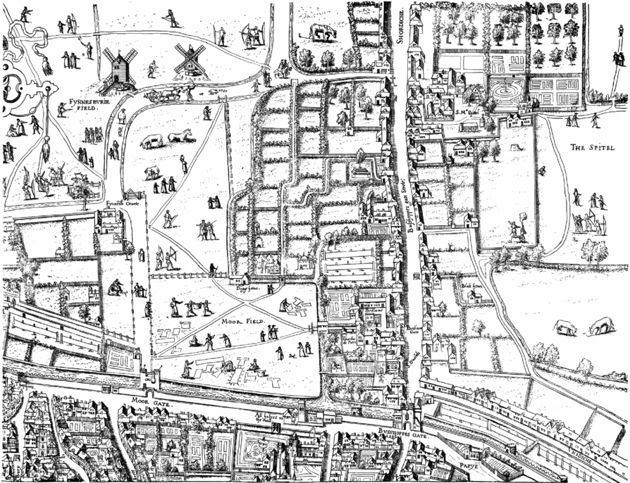
Moorfields is an area north and outside of the city walls of London. Here, in 1415, the mayor of London, Thomas Fauconer, and aldermen, together with ‘an immense congregation of very reputable men of the city’, set about dividing up the moor into gardens ‘to be let out to the profit of the city chamber’ (Figure 4).Footnote 52 These ‘agents of change’ included both civic officials and citizens, led it seems by Fauconer as mayor. What makes this example of urban planning by committee all the more remarkable is the entry made in the Letter Book for that year, which states:Footnote 53
Figure 4 Moorfields as shown on Frans Franken copperplate map of London, 1559. The area referred to in 1415 lies to the north of the city wall, shown in 1559 as an area of gardens with narrow alleys running ‘lengthwise and across’, as described in the Letter Book account. Image © Museum of London.
And that upon the Moor aforesaid there should be laid out divers gardens, to be let at a proper rent to such persons as should wish to take them, alleys being made therein lengthwise and across; as more plainly depicted and set forth on a certain sheet of parchment, made by way of pattern for the plans aforesaid, and shown to the said Common Council, and exhibited.
The planning process captured here by contemporary written accounts shows individuals working together, dividing up lands and setting out alleys (seemingly to a grid-plan), as well as using a visual depiction ‘by way of pattern for the said plans’.
The ‘certain sheet of parchment’ drawn to show the plans for Moorfields no longer appears to survive, a warning to those who might use surviving medieval maps and plans as a basis from which to calculate the historical development of English cartography. Indeed, the Moorfields example seems to counter the view held among historians of English cartography, that ‘the development of surveying in medieval England and the drawing of local maps and plans followed courses that were quite independent of one another’, until the sixteenth century when ‘a union was effected. . .between separate traditions of surveying and map-making’.Footnote 54
The Moorfields evidence shows instead that urban planning in the later Middle Ages required not only the input of surveyors, for measuring the land and calculating the size and extent of new plots, but also the use of drawn plans for the purpose of planning. This is more akin to the modern meaning of ‘planning’, that is, working from plan, and its presence in London in 1415 diminishes the distinction often drawn by historians between medieval and later town-planning. Fauconer's plan offers a glimpse of an urban-planning process at work in England in the first century after the Black Death. It was a process that required various ‘agents of change’ (as urban morphologists term them) working together in planning for the future, and using techniques such as surveying and cartography to help them in their work. Footnote 55
Plans and planners in later medieval England
Harvey has noted that ‘in the fourteenth and fifteenth centuries no new techniques were applied to surveying nor is there any trace of the growth of a class of professional surveyors in England’.Footnote 56 Yet, by the fifteenth century, London had salaried officials including a ‘city surveyor’ as well as a planner, engineer and architect.Footnote 57 The planning work being undertaken at Moorfields in 1415 reveals something of the surveying roles performed by such local and civic officials in the city. At Southampton, too, the town was carefully and minutely surveyed, in 1454, street by street, property by property, ‘for the reperacons and stopping of loops in the towne walls and who was chardged there vnto’.Footnote 58 Such surveys of towns were as much a state concern as a municipal one. For example, in the 1360s at Calais a royal commission was appointed to survey the town and ‘all the tenements. . .measured by the commissioners by the English yard of four quarters’ in the presence of a jury of 11 burgesses.Footnote 59 These careful (textual) surveys of urban lands were occurring at around the same time as (visual) plans and drawings were being made, either of proposed changes to existing urban landscapes, as seen at Moorfields, or in recording what was there, as in the case of plans surveyed in London for the city's bridgewardens, recording lands in Deptford and Lambeth in the 1470s.Footnote 60
In undertaking their tasks and duties – as surveyors to measure and calculate as well as to record – those ‘agents of change’ commissioned during the later fourteenth and fifteenth centuries, seem strikingly familiar. Indeed, nowadays their surveys and plans might be regarded as typical for ‘urban planning’ work, yet in modern histories of European urban planning these medieval planners have been somewhat overlooked.Footnote 61 The activities of such planners in England also compare with others working elsewhere in Europe at this time on engineering and planning in urban improvement projects, such as the new port proposed at Valencia in 1492 and led by John Cabot.
Cabot ‘designed and painted plans’ of his proposals for Valencia, and also subsequently, significantly, resided in England as a merchant in Bristol in the 1490s, in order ‘to sail to all parts, regions and coasts of the eastern, western and northern sea’, under letters patent issued by Henry VII in 1496.Footnote 62 With his Venetian origins, his abilities in navigation and map-making, his expertise in civil engineering and planning projects, and familiarity with English towns and cities, John Cabot – and doubtless others like him – formed part of a European-wide network of ideas and practices relevant to urban planning.Footnote 63 A basis existed for fostering such knowledge exchange through the influence of Italian engineers and technologies on coastal works in southern England and their associated maps and plans of Henry VIII's reign.Footnote 64 There were Italian mercantile communities and enclaves that existed in London, Southampton and Bristol, acting not just as conduits of trade and commerce but as cross-cultural networks transferring ideas too.Footnote 65 Cabot's activities were indeed well known among civic authorities both in London and Bristol, and reported on by local chroniclers.
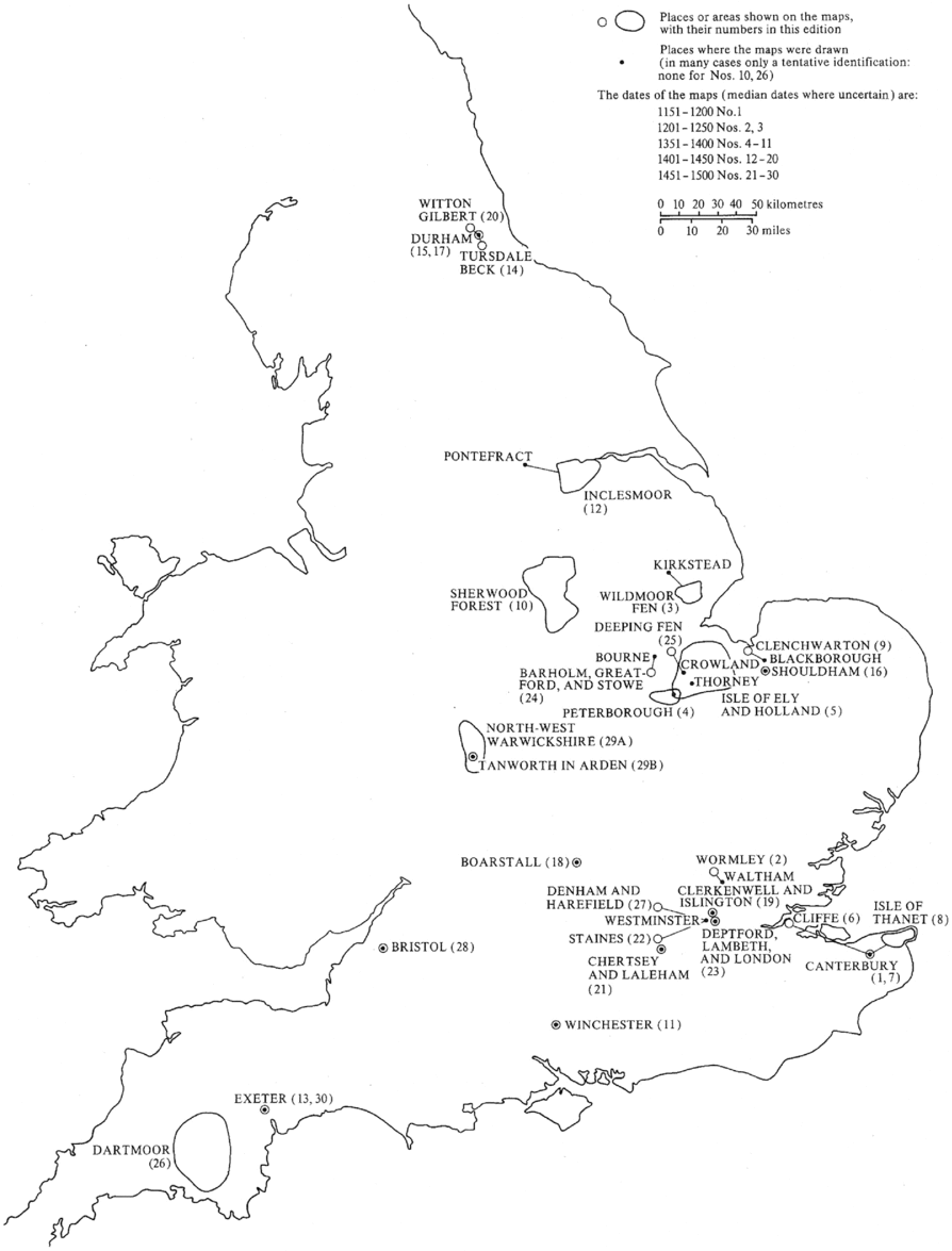
One possible reflection of this potential in trading cartographic ideas and surveying practices within urban spheres is a marked preponderance towards localities in the south and east of England for those surviving examples of ‘local maps and plans’ from the fifteenth century, notably for places in and around London (Figure 5).Footnote 66 The geographical provenance of these local maps and plans, and perhaps the expertise that went into creating urban surveys and planning from plans, might thus be linked with traditions of survey being used elsewhere, in the neighbouring Low Countries, or from Italy, for example, where similar civil and civic planning projects were being carried out. Cabot's circuit of operation – between Italy, Spain and England – is a reminder of the broad geographic compass individual ‘agents of change’ had in English towns and cities, through whose planning and cartographic expertise were forged closer connections between ‘Renaissance’ Europe and ‘Tudor England’. The plans and planning being carried out in England after the Black Death provide but one reflection of this expanding inter-connected urban ‘world’ of the later Middle Ages. While the idea of employing ‘professional’ surveyors may have been alien, there were all the same commissioned individuals working in English towns and cities who were clearly expert in matters of planning and using surveying as a part of the planning process.
Figure 5 A ‘map of maps’: the incidence of surviving local maps and plans from medieval England, from R.A. Skelton and P.D.A. Harvey (eds.), Local Maps and Plans from Medieval England (Oxford, 1986), frontispiece (reproduced with permission of P.D.A. Harvey). Since publication of this map, further examples of local maps and plans from medieval England have emerged, including one further map from Lincolnshire, and two of Romney Marsh (Kent): see P.D.A. Harvey, ‘Medieval local maps from German-speaking lands and central Europe’, in G. Holzer, T. Horst and P. Svatek (eds.), Die Leidenschaft des Sammelns, Österreichische Akademie der Wissenschaften, Philosophisch-historische Klasse, Edition Woldan 3 (Vienna, 2010), 113–32, at 114.
From the indicative examples considered here, the role of using drawings and plans as part of surveying and planning work was certainly present in England in the fifteenth century. This suggests some re-evaluation is required in how surviving maps and plans of the period are understood. For example, Harvey and Skelton contend that ‘given the medieval unfamiliarity with maps, it seems most unlikely that anyone could even think of making a plan from a survey’, and that ‘the end product of the surveyor's work was not a map, but a written description, giving the area of each piece of land and identifying the lands that adjoined it’.Footnote 67 While in some cases, as at Winchelsea and Southampton, for example, this is borne out, there are other cases, notably those plans in London of lands at Moorfields and Lambeth, which show that some maps and plans of this period were being prepared from survey for planning purposes. There are grounds, therefore, to begin to reappraise the connections between urban planning and urban plans and surveys of the later Middle Ages, and to explore further the kinds of techniques and expertise required for making these.
Historians of cartography generally see in the sixteenth century a ‘cartographic revolution’, in which plans and maps become more widely used in government, law and exploration, while England in the fifteenth century is often portrayed as a bit of a back-water in cartography.Footnote 68 Yet, the fifteenth century might be seen instead as a fertile period in English map-making and planning new urban landscapes. Surveying what was there, as well as what was intended, provided some of the context and perhaps even stimulus for this use of plans in planning. Furthermore, contra Beresford, far from being a ‘sterile period’ of two and a half centuries between the foundation of Queenborough and Falmouth, the period after 1350 reveals English towns and cities undergoing continued urban change, just as was the case in continental Europe.
The nature of urban planning in this period, through the creation of new towns and suburbs, as well as civic improvements, points to parallels between English and European urban experiences, drawing connections between Atlantic and Mediterranean worlds.Footnote 69 Such townscape transformation was not simply limited to corporate prestige projects and public works – such as guild halls, urban defences, or mills – but encompassed urban planning at different scales and with different forms, from large areas made available for new urban development, through to the localized renewal of building fabric.Footnote 70 All of these were overseen by various authorities and decision-makers, such as civic officials and royal agents, planners and surveyors, and through their combined activities townscapes in late medieval England were transformed in a coordinated and planned way.
Conclusion
The civic improvements taking place in Norwich after 1350 seem to pay no heed to the assumed impact of the Black Death. As at Coventry, the later fourteenth century instead sees prosperity and continued urban planning, with investing for the future being a sign perhaps of optimism rather than pessimism in urban fortunes. The activities of those involved in urban planning after the Black Death in England, men such as Fauconer, Blaumester and Peverell, shared in the common enterprise of transforming townscapes, reflecting, evidently, a decision-making process that involved a variety of individuals, with varying specialisms and expertise, from surveying streets and plots, to setting out defences, and from negotiating between different parties and factions, to providing written and in some cases drawn plans and proposals. The evidence, then, whether from the creation of new towns as at Bewdley, or more subtle forms of planning, as in Moorfields and Winchelsea, indicate a concern for and interest in urban development and planning after the Black Death in England across the urban hierarchy.
The application of morphological ideas and concepts from geographers such as Conzen and Slater help to conceptualize the townscape transformations that resulted from urban planning after the Black Death. Urban landscapes were physically shaped through both ‘additive’ and ‘augmentative’ processes, both of which had shaped towns and cities for centuries throughout the Middle Ages. As such, urban planning after the Black Death was largely little different in form to that which had existed before. While certain contemporaries bemoaned how there were, in some English towns and cities, ‘desolate and void groundys, with pittys, sellers and vaultes lying open’, the two centuries after the Black Death also saw ‘new towns’ being successfully formed and various planning schemes for civic improvements and public works being put in place.Footnote 71 Further local studies of particular places, especially those that were prospering rather than declining, may well yield examples that lend support to the picture outlined here of urban planning continuing to transform medieval townscapes in England after 1350.
What does seems to change in the period after 1350 is the visibility that urban planning has in civic and state records. Rather than a surge in urban planning itself, this trend perhaps reflects the more careful, corporate documenting of activities of certain ‘agents of change’, particularly under civic and royal officials and administrators with an eye on financial accountability. As far as additive or augmentative processes of urban development in English towns and cities are concerned, the Black Death seems to have had less negative impact than is often supposed. Instead, in England, as in Europe more widely, contemporary visual depictions and textual accounts reveal urban landscapes characterized not by urban stasis and restraint in the later Middle Ages but on-going renewal, transforming townscapes. As such, it is surely time to reconsider the post-Black Death centuries as a formative period in English planning history and to begin to rewrite some of those urban histories that have for too long overlooked it.