


INTRODUCTION AND PREVIOUS WORK IN THE AREA
The Norwegian Archaeological Survey in the Karystia (NASK) was a five-year field project focused on the Katsaronio plain, a part of southern Euboea centred around the town of Karystos (i.e. the Karystia). The project took place over the course of five field and study seasons (2012–16) and was organised under the aegis of the Norwegian Institute at Athens with a permit granted by the Hellenic Ministry of Culture. The aims of the project were to: (1) conduct a systematic archaeological study of a previously uninvestigated part of southern Euboea; (2) look for diachronic evidence of occupation, use and social structuring of this economically important section of the Karystian landscape; (3) recover additional evidence for the earliest recorded human presence in the Karystia – currently dated to the Late Neolithic phase (cf. Mavridis and Tankosić Reference Mavridis, Tankosić and Tsirtsoni2016a) – and thereby contribute to the issue of the first permanent settlement of southern Euboea and the Cycladic islands; and (4) provide an opportunity for students of archaeology and related fields to gain fieldwork experience.
The general fieldwork related to the project began in 2012 and was completed in 2014. In 2015–16 we revisited several known sites; this revisit, however, also revealed five new findspots. While the collected data is undergoing further analysis, we present here a preliminary but comprehensive account of what we have learned thus far. Following the discussion of the survey methods, we present the main archaeological materials collected by NASK: pottery and lithics dated to prehistoric phases (Final Neolithic and Early Bronze Age) and pottery dated to the historic phases (Archaic, Classical, Hellenistic, and Roman). These materials were the predominant finds recovered during the survey and the most important materials for providing chronological control of the findspots. We have found no evidence of other prehistoric phases, and the amounts of post-Roman surface materials are very limited, testifying to different habitation and use patterns than in other parts of the Karystia.
NASK adds to the long history of archaeological survey in southern Euboea. Several scholars under the leadership of Hugh Sackett conducted the first systematic survey of the entire island of Euboea including the Karystia, the results of which were published in a seminal 1966 paper (Sackett et al. Reference Sackett, Hankey, Howell, Jacobsen and Popham1966). The Karystia was also a part of extensive surveys organised by Dimitrios Theocharis (Reference Theocharis1959) and Adamantios Sampson (Reference Sampson1981), which specifically targeted the prehistoric remains on the island.
The systematic archaeological research targeting the Karystia only commenced in the late 1970s, with Donald Keller's (Reference Keller1985) diachronic survey of the area around Karystos for his doctoral dissertation at Indiana University. Keller's work was continued by the Southern Euboea Exploration Project (SEEP), which was founded in 1984 by Keller and the late Malcolm Wallace of the University of Toronto, to promote research into the Karystian past. Since its establishment, SEEP has conducted three systematic surface surveys in the area: the survey of the Paximadi peninsula (Cullen et al. Reference Cullen, Talalay, Keller, Karimali and Farrand2013); the ‘route survey’ of the portions of the Bouros-Kastri region located east of the Bay of Karystos (Wickens Reference Wickens, Rupp and Tomlinson2011; Wickens et al. Reference Wickens, Rotroff, Cullen, Talalay, Perlès and McCoy2018); and the survey of the Karystian plain, also known as the Kampos (Tankosić and Chidiroglou Reference Tankosić and Chidiroglou2010). These surveys discovered and mapped hundreds of previously unrecorded archaeological sites. Finally, the Ephorate of Antiquities of Euboea has conducted several rescue excavations over the years that have greatly augmented the knowledge obtained from surface surveys about the area's past.
NASK AREA
The target area in the Katsaronio plain, situated between the villages of Marmari and Katsaroni, occupies about 20km2 of the valley itself and the foothills of the surrounding hills and mountains (Fig. 1). To remain within the limits proscribed by the Greek antiquity law, to avoid arbitrariness, and to emphasise the agricultural nature of the region, we defined the survey area as land below 12 per cent slope, as this is the inclination commonly considered as the maximum for unaided agriculture (i.e. without constructing agricultural terraces). This boundary remains arbitrary for later prehistoric and post-prehistoric periods when such improvement works were common, but it is still a valid criterion for earlier prehistoric phases (e.g. pre-Middle Bronze Age; French and Whitelaw Reference French and Whitelaw1999), for which the evidence for such improvement works is ambiguous.

Fig. 1. Location of the NASK area in the Karystia, southern Euboea. Map by R.M. Seifried.
According to the 1:50,000 Karystos-Platanistos Sheet Geological Map of Greece (Institute of Geology and Mineral Exploration), nearly the entire survey area consists of alluvial deposits and schists, including quartzite and amphibolitic schists. The area is well-watered by two perennial streams and a number of smaller seasonal streams that flow into them. The most important stream, Megalo Rema, collects all the water in the area and flows north, meeting the Aegean Sea at Giannitsi beach, just east of Filagra bay. Numerous springs and wells – as well as runoff from rain and winter snow that accumulate in the surrounding mountains – supply water to the plain, especially from Mt Ochi, located east of the Katsaronio plain. The Katsaronio can roughly be divided into two subsections: (1) northern, consisting of a narrow strip of alluvial land along the course of the Megalo Rema, starting 3.5km north of the village of Chania, and (2) southern, which includes the rest of the plain and forms a shallow bowl-like depression (Fig. 2). To the south, the plain is separated from the rest of the Karystia by the relatively low Lykorema ridge, while the ground elevation along the Giannitsi-Figias ridge (to the north-west) and the Keratoura-Taboukia ridge (to the north-east) is considerably steeper.

Fig. 2. NASK area, with major place names and geographical features. Map by R.M. Seifried.
Three important modern communication routes pass through the Katsaronio plain today. They connect Karystos with the rest of Euboea and Chalkida on one side, as well as the northern shores of southern Euboea and the villages of Giannitsi and Kallianou on the other. There are three principal settlements in the area: the villages of Katsaroni, Paradeisi, and Chania, in addition to several smaller hamlets or individual farmsteads. The land along the Karystos–Chalkida road is officially zoned off for industrial purposes and was not entirely surveyable as a result, since it is heavily disturbed or paved over. The rest of the Katsaronio plain is presently used for activities connected to agriculture and animal husbandry.
Modern vegetation cover includes plants grown for their subsistence or economic importance (chiefly wheat, olives, and grapevines, but also a variety of vegetables); phrygana consisting of short thorny shrubs and herbaceous vegetation that covers most of the slopes of the surrounding hills; and pockets of oak, fir, and other trees. Hemp is often found along the perennial or seasonal riverbeds, but we are unsure whether it was introduced there for economic reasons, and if so, when.
The plain's agricultural potential, its favourable position along the main land route connecting southern Euboea with the rest of the island, and the absence of systematic archaeological research in the area were among the main reasons this area was targeted for systematic survey. We expected to find rich evidence of past human presence in the Katsaronio, since agriculture has been the main economic and subsistence activity of the people living in the Karystia from prehistoric to modern times. Overall, the project set out to discover the long-term change of agriculture- and husbandry-related economic activities in a delimited and clearly bounded geographical area.
We particularly expected that the Katsaronio plain's agricultural potential would be attractive to early agriculturalists and horticulturalists from Neolithic times, hoping to solve a long-standing issue of the original peopling of the Karystia and the Cycladic islands, which seem to be chronologically related: namely, the known population history of southern Euboea, where the earliest evidence for human presence does not predate the Late Neolithic (LN), follows the pattern observable in the neighbouring Cycladic islands. This contrasts with the rest of Euboea, where human habitation was well established at least in the Early Neolithic, if not before (Mavridis and Tankosić Reference Mavridis, Tankosić and Tsirtsoni2016a). In connection to this, the earliest LN evidence in the Karystia has been found at one site only so far, the Agia Triada cave (Mavridis Reference Mavridis, Tankosić, Mavridis and Kosma2017; Mavridis and Tankosić Reference Mavridis, Tankosić and Tsirtsoni2016a; Tankosić and Katsianis Reference Tankosić, Katsianis, Sarris, Kalogiropoulou, Kalayci and Karimali2017), which is not suitable for habitation. The Karystia is considered one of the potential staging points for the colonisation of the Cycladic islands at the end of the Neolithic – or at least a contributor to the populations that permanently settled them (e.g. Broodbank Reference Broodbank2000). Hence, we hoped that the Katsaronio would give us evidence for contemporaneous habitation, since such data has not been forthcoming from elsewhere in the Karystia thus far. We also hoped to find evidence for post-Early Bronze Age prehistoric activities, which has thus far been very limited or entirely absent.
In terms of the historic periods, we expected to find plentiful evidence of exploitation due to the favourable agricultural potential of the area, its relative proximity to the sources of the Karystian cipollino marble, and its position along the main communication routes leading into and out of the Karystia. Based on the survey of the Kampos plain to the south (Tankosić and Chidiroglou Reference Tankosić and Chidiroglou2010), we anticipated finding substantial evidence from the Roman and Early Byzantine phases in particular.
SURVEY METHODS
We designed the survey fieldwork and recording methods around the desire to achieve total and efficient coverage of the entire target area and, whenever possible, to record evidence of ephemeral and/or seasonal habitation and use of the landscape. In 2012 we obtained 50cm resolution satellite images of the area from European Space Imaging that showed in great detail the natural and manmade structures existing at that time. We used these maps as the primary tool for orientation in the field, with handheld Garmin GPSMAP 62st receivers used for navigation. We adopted the method of arbitrary transect survey, with transects spaced 10m apart and walked in straight lines, irrespective of modern field boundaries. This approach allowed us to eliminate potential bias introduced by relying on modern landscape divisions and to expedite the fieldwalking process, especially as many of the field boundaries were not clearly visible in fallow parts of the survey area.
We employed two different transect methodologies over the course of the project: a grid-based survey in 2012 (limited to the area south of the Karystos–Chalkida road), and a free-flowing survey in 2013–14 (all area north of the road). The project began by establishing an arbitrary grid oriented north–south over the survey area, dividing the area into 100 x 100m squares that were then walked by teams of up to 10 surveyors at a time. Surveyors counted every artefact or feature in their transect and recorded them on specially designed paper forms. Non-diagnostic fragments of pottery were counted but left in situ, while diagnostic pottery and all stone tools were both recorded and collected. The distinction between diagnostic and non-diagnostic pottery was made in the field, under the supervision of the field directors. This method allowed us to collect rough counts of artefacts for each grid square covered by the surveyors (Figs 3 and 4).
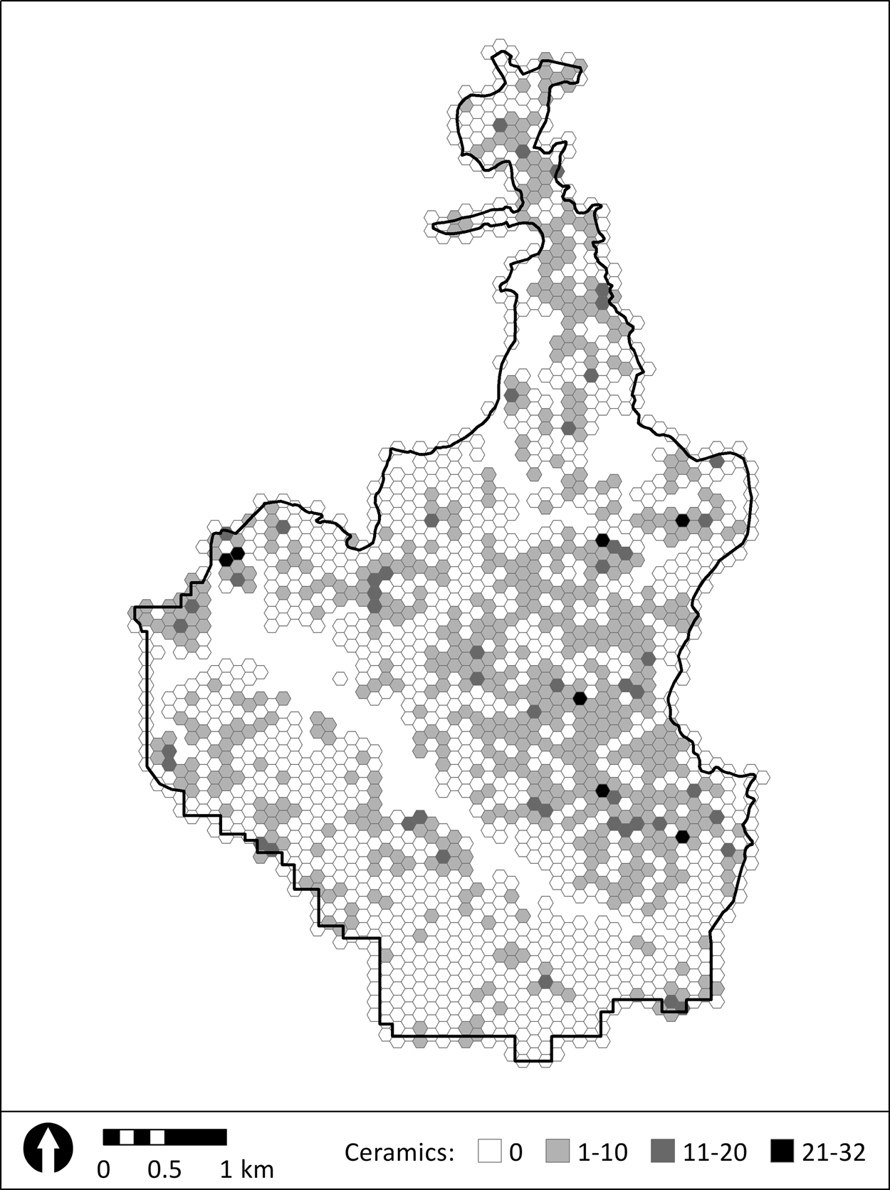
Fig. 3. Distribution of off-site ceramics collected during transect survey, generalised in 1-ha tessellations. Finds collected during intensive findspot survey are not shown. Unsurveyed areas are absent of tessellations. Map by R.M. Seifried.

Fig. 4. Distribution of off-site lithics collected during transect survey, generalised in 1-ha tessellations. Finds collected during intensive findspot survey are not shown. Unsurveyed areas are absent of tessellations. Map by R.M. Seifried.
This process was greatly improved and accelerated in the 2013 season, when we introduced a new recording method using Android-based tablets operating ‘ODK Collect’ software. Each surveyor was issued one tablet pre-loaded with a digital recording form. Taking advantage of the tablets’ built-in GPS capability, every artefact found on the surface was tagged with a GPS coordinate with 5m accuracy, regardless of whether it was collected or not. With the new tool, we were able to adopt a free-flowing survey method, in which transects were continuous and could cut through multiple arbitrary survey squares, natural or man-made boundaries, and vegetation zones. The correct spacing of such transects and the complete coverage of designated survey areas was ensured by team leaders who followed behind the surveyors and marked off the survey areas on the 50cm satellite maps. The free-flowing method greatly increased the speed and precision of the recording process as well as the quantity of collected off-site data.
When concentrations of artefacts large enough to be termed ‘findspots’ were found, the general survey was stopped and a more detailed recording method employed (Fig. 5). Team leaders defined findspots during the survey process based on real-time feedback from the surveyors. We considered a findspot to be any concentration of material greater than 10 fragments of ceramics or five fragments of lithics within a 50 x 50m area. We also recorded any architectural remains or other features (e.g. pits, quarries, rock cuts) as separate findspots. We believe that such an expansive definition allowed us to record material evidence left by even short-term past activities. Findspots were assigned an identification comprised of year in which they were recorded followed by a continuous number (e.g. 12–8). During later revisits, we concluded that some of the individually recorded findspots were part of larger contiguous scatters, and we updated their identification accordingly (e.g. 12–8/9). In this text, when referring to a findspot, we use only its number and omit the year unless necessary to resolve ambiguities.

Fig. 5. Findspots identified during NASK according to broad chronological period. Map by R.M. Seifried.
Findspots were recorded by surveyors walking in transects spaced 2m apart (approximately arm's length). During the process, surveyors followed natural or artificial landscape features or, where those were not available, cardinal directions. All visible artefacts were collected, and all features were recorded. When the surveyors walked at least 50m without a significant (10+ pieces) number of artefacts, this was considered the boundary of the findspot and detailed survey was stopped. All the artefacts were pooled and counted, but only diagnostic pottery and all lithic artefacts were kept. Our goal was to record the variability of surface artefacts and obtain a representative sample for further study. At the end of each day in the field, the collected data was uploaded to an ODK data collection tool to eventually be transferred to a FileMaker Pro database, and artefacts were deposited in the Archaeological Museum of Karystos for further processing by the museum team.
Ground visibility and the extent of plant cover varied across the landscape and likely influenced the results of the survey. The visibility ranged from nearly 100 per cent (mostly in agricultural areas under current cultivation) to near 0 per cent in overgrown fallow fields. The influence of visibility on the results could easily be observed even in the field, where rich findspot scatters would abruptly cease at the terminating edge of cultivated areas. One of the drawbacks of the arbitrary transect method, especially during the post-2012 seasons, was the inability to collect detailed field data about surface visibility. Since the continuous transects cut across multiple vegetation/cultivation zones, it was impractical to record them using the survey forms which focused on the recovery and recording of cultural remains. Fortunately, however, most of the survey area consisted of fields under cultivation, and we believe that uneven visibility did not affect our results too adversely. Nonetheless, it should not be discounted as a limiting factor that could have introduced a degree of bias. We plan to ameliorate this issue during the final analysis by using satellite vegetation overlay maps in combination with archaeological survey data.
In this way, we examined c. 78 per cent of the total designated survey area. The dark-shaded areas on Fig. 2 show the sections of the Katsaronio plain we did not survey for various reasons. For example, we generally skipped the areas that were paved over, usually due to industrial development, particularly along the Karystos–Chalkida road. We also did not survey inside the areas that were part of inhabited settlements, along the heavily eroded or overgrown stream beds, the parts with very steep ground inclination, especially if heavily overgrown, and otherwise inaccessible areas with 0 per cent ground visibility.
In the following pages, we present the results of the Katsaronio survey chronologically. Following this, we offer an interpretation of the gathered data. This report is not intended to be exhaustive, but rather to provide a general overview of the most important results in expectation of the completion of data analysis and of the final comprehensive publication.
The project recorded 99 findspots ranging in date from the end of the Neolithic to the Early Modern periods (see Fig. 5). There were, however, substantial gaps in the archaeological record that cover several millennia (e.g. no Middle and Late Bronze Age and Geometric, and little Archaic, Roman, Byzantine, and post-Byzantine material). In absolute and relative terms, the greatest number of finds, whether from findspots or survey transects, can be dated to the following phases: Final Neolithic (FN), Early Bronze Age (EBA), Classical, and Hellenistic.
SURVEY FINDS FROM THE PREHISTORIC PERIODS
At least 21 prehistoric findspots were recorded in the Katsaronio plain, with the total number possibly as high as 33 (see Fig. 5). The findspots vary considerably in the size and composition of the surface scatter. All identifiable prehistoric material found during the Katsaronio survey can be dated, with greater or lesser degrees of certainty, to either the FN or the EBA phases. Generally speaking, both pottery and lithics – the latter by far the most dominant type of find – appear very worn and weathered, which is not unexpected when dealing with surface scatters.
Pottery
Although found in relatively large quantities at some findspots, the prehistoric ceramic material is very fragmented, with a small number of diagnostic or otherwise chronologically distinctive sherds. A large number of findspots did not yield any ceramic material at all, making their chronological designation difficult. The largest amounts of pottery come from findspots 2/4 (Choni), 8/9 (Gourimadi), and 21/22 (Dexameni), all of which are located along the southern edge of the Katsaronio plain. Additional (and more ambiguous) ceramic evidence comes from findspots 26, 53, 72, and 75. This summary does not include several individual finds of prehistoric pottery recovered throughout the survey area.
The FN pottery is represented by approximately 50 fragments. Typical shapes include rounded bowls with vertical or spreading thinned rims (found at 2/4, 21/22; Fig. 6a) and cheesepots (2/4, 8/9, 21/22; Fig. 6b). Structural or decorative elements such as elephant lugs (21/22; Fig. 6c), small strap handles (8/9; Fig. 6d) and perforated lugs (8/9; Fig. 6e), rows of incised lines (2/4, 8/9; Fig. 6f), spool-shaped perforated (2/4; Fig. 6g) or plain lugs (8/9), taenia bands with finger impressions (8/9; Fig. 6h), and red-slipped and burnished surfaces (21/22) are indicative of this prehistoric phase. Several joints found on the surface indicate the presence of footed vessels – primarily bowls, judging by their size. Unfortunately, their poor preservation prevents any reconstruction attempts. These pottery features, however, are reminiscent of the later section of the FN or even a FN/EBA I transition, as suggested by some authors (Caskey and Caskey Reference Caskey and Caskey1960; Cullen et al. Reference Cullen, Talalay, Keller, Karimali and Farrand2013, 71–4; Tzavella-Evjen Reference Tzavella-Evjen1985). The presence of a possible sherd belonging to a rolled-rim bowl (2/4; Fig. 6i) and the absence of pattern burnishing, which is usually associated with earlier FN subphases, seem to support this assertion (cf. Pullen Reference Pullen2011, 20, 25).

Fig. 6. Sample of the prehistoric pottery recovered from the survey. Drawings by A. Djordjević and A. Kapuran.
Ceramics from the mature EBA phase (EBA II) seem to be even less well represented in the Katsaronio assemblage. Several sherds from findspot 25 are the most likely candidates for an EBA II date; however, this is far from certain as it is based on their general appearance and not on any specific EBA features. There is also a possibility that some of the footed vessels and vessels decorated with taenia bands can be dated to this phase, since they are commonly found throughout the FN–EBA continuum.
The fabric of the prehistoric pottery was macroscopically examined using a 10x magnification geological lens for consistency. There are no observable changes in the fabric between the FN and EBA phases, which is consistent with observations made elsewhere in the Karystia (e.g. Cullen et al. Reference Cullen, Talalay, Keller, Karimali and Farrand2013; Mavridis and Tankosić Reference Mavridis and Tankosić2009; Reference Mavridis, Tankosić and Tsirtsoni2016a; Reference Mavridis and Tankosić2016b; Tankosić and Mathioudaki Reference Tankosić and Mathioudaki2011). All pottery collected from prehistoric findspots was made of local clays, either medium or coarse in quality. The clay contains inclusions commonly found in prehistoric (and later) pottery from the Karystia and also found locally in abundance, such as whitish rock (most likely quartzite), schist, and silver mica. The ceramics were generally well fired, producing surface colours ranging from red (Munsell 2.5YR 5/8) to reddish yellow (Munsell 7.5YR 6/6), with most sherds falling in the yellowish red (Munsell 5YR 5/6–5/8) group.
Lithics
In this section we present a holistic picture of the lithic assemblage that was collected both as individual finds and from concentrated findspots. A total of 9,481 lithics were recovered (Table 1), the vast majority of which were made of obsidian. This constitutes one of the largest obsidian lithic assemblages ever recovered via archaeological survey in Greece. While obsidian is the primary raw material, several other raw materials are present, including quartz, reddish-brown chert, grey flint, low-quality reddish-brown chert, low-quality brown chert, crystal quartz, and white/beige flint.
Table 1. Total counts of lithics recovered during the survey.

The vast number of lithic finds made the exposition of detailed information about each piece impractical. Instead, the analysis focused on aggregates of findspot material. For each group, the pieces were sorted, counted, and examined macroscopically. Basic information was recorded about reduction techniques and diagnostic types using the European lithic typology, with some variations tailored to the needs of the study (Cherry and Torrence Reference Cherry, Torrence, MacGillivray and Barber1984; Perlès Reference Perlès1987; Karimali Reference Karimali1994; Kardulias and Runnels Reference Kardulias, Runnels, Runnels, Pullen and Langdon1995; Inizan et al. Reference Inizan, Reduron-Ballinger, Roche and Tixier1999; Parkinson and Cherry Reference Parkinson and Cherry2010; Pelegrin Reference Pelegrin and Desrosiers2012). Specifically, platform preparation, knapping techniques (where feasible), blank types, tool types, and some auxiliary remarks, when necessary, were recorded for each piece.Footnote 1 This allowed for the identification of areas where reduction took place, the extent to which reduction occurred, and the dating of each assemblage.
Ten of the 21 certain prehistoric findspots contained more than 100 lithics each (Table 2). From findspot 8/9 (Gourimadi) – the most abundant of the 10 – we recovered 3660 pieces, the majority of which are obsidian. This assemblage contains 413 spalls, 373 blade fragments, 16 cortical flakes, 11 core fragments, 14 technical pieces, and thousands of flake fragments, indicating that reduction took place in the area. We identified a total of 180 tools, a large part of which constitutes heavily eroded arrowheads (53 in total; Fig. 7). Most of the arrowheads are tanged and barbed with bifacial retouch, bearing typological characteristics encountered on other points from the LN and FN periods at a number of sites in Greece (Perlès Reference Perlès2004; Sørensen Reference Sørensen, Diez and Moschos2006; Moundrea-Agrafioti Reference Moundrea-Agrafioti and Zachos2008). From findspots 21/22 (Dexameni) and 2/4 (Choni) – the second and third most abundant – we recovered 1742 and 1289 pieces, respectively, with obsidian making up 99 per cent of the two assemblages. Both are also characterised by large amounts of debitage and tools. The blades from findspot 21/22 are predominantly irregular in shape, which indicates the possible application of indirect percussion. The largest percentage of tools was found at findspot 71 (Mantra 2) (45 out of 164 pieces). The remainder is comprised of 68 flake fragments, 34 blade fragments and 15 spalls. The presence of thin parallel-sided blades in this industry is a clear indication of pressure technique; most of the blades also have flat and linear butts.
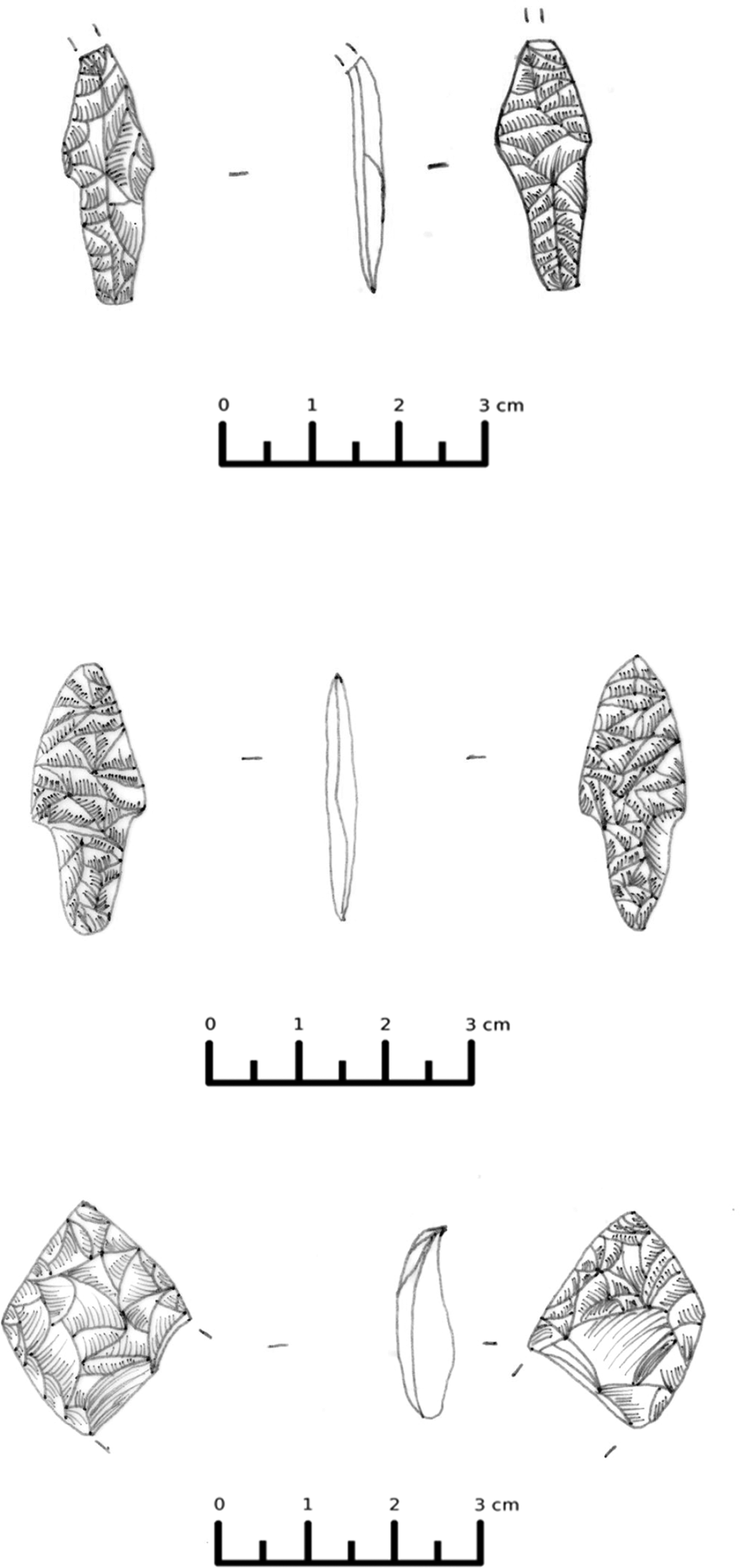
Fig. 7. Obsidian arrowheads. Drawings by A. Psoma.
Table 2. Findspots with the highest density of lithics.

The analysis of this impressive assemblage provides us with clues regarding the use and procurement of lithics in the area. The large quantity of obsidian artefacts, which constitute the vast majority of the assemblage, indicates that obsidian was the primary raw material for lithic production, as at other FN (Cullen et al. Reference Cullen, Talalay, Keller, Karimali and Farrand2013; Mavridis and Tankosić Reference Mavridis, Tankosić and Tsirtsoni2016a) and EBA sites in Euboea (Tankosić Reference Tankosić2011; Mavridis and Tankosić Reference Mavridis and Tankosić2016b; Tankosić and Katsianis Reference Tankosić, Katsianis, Sarris, Kalogiropoulou, Kalayci and Karimali2017). Moreover, judging by the large numbers of debitage pieces at some of the findspots, paired with evidence of most of the phases of the reduction sequence, we can conclude that extensive reduction did occur in these areas. These findspots seem to have played a central role in the production and redistribution of the artefacts (e.g. findspot 8/9 [Gourimadi]). Further analysis will help determine the role of these sites in the circulation of obsidian in the wider area. While we are able to identify some of the loci where reduction took place, it is difficult to conclude unequivocally in which form the raw material arrived at the sites.
Pressure flaking was the preferred knapping technique for obsidian blade production, although some of the blades may have been manufactured using indirect percussion. Moreover, the composition of the lithic assemblage from some of the findspots suggests that they were very active in the lithic exchange network. The findspots that were characterised by the largest number of artefacts and by an advantageous (i.e. defensible) geographical location – such as 8/9 (Gourimadi), 21/22 (Dexameni), and 2/4 (Choni) – also revealed large numbers of debitage and flake fragments, with only relatively fewer blade fragments. This marker of intense manufacturing, together with the geomorphological characteristics of the findspots and their position in relation to the coast, may suggest that they acted as intermediary nodes in the obsidian exchange network, where raw material underwent some degree of preparation, before being supplied to surrounding areas (Cullen, Talalay and Tankosić Reference Cullen, Talalay, Tankosić, Rupp and Tomlinson2011; Cullen et al. Reference Cullen, Talalay, Keller, Karimali and Farrand2013). Moreover, the important role that site 8/9 (Gourimadi) played in the production of chipped stone at the end of the Neolithic period is confirmed by the exceptional amount of debitage recovered during subsequent excavations (Gourimadi Archaeological Project, 2018–19) which have yielded more than 7000 obsidian artefacts (Tankosić et al. Reference Tankosić, Mavridis, Zafeiriadis and Psomaforthcoming).
A considerable number of tools were identified in certain findspots, with marked variation in typology. Tool types include becs, splintered pieces, denticulates, end-scrapers and retouched blades (Fig. 8). Numerous arrowheads were collected as well, particularly at findspot 8/9 (Gourimadi). There, arrowheads constitute the largest percentage of tools. As of this writing, a total of 171 LN/FN obsidian arrowheads from Gourimadi have been analysed (from both the NASK and the Gourimadi excavation), making this the largest collection of obsidian arrowheads ever uncovered in Greece. The exceptional amount of debitage and large number of arrowheads confirms that the knapping process was related to specialised activity. All the above, in conjunction with the site's privileged geographic position, indicate that this site played a significant and central role in the specialised craft production and exchange network of the region.
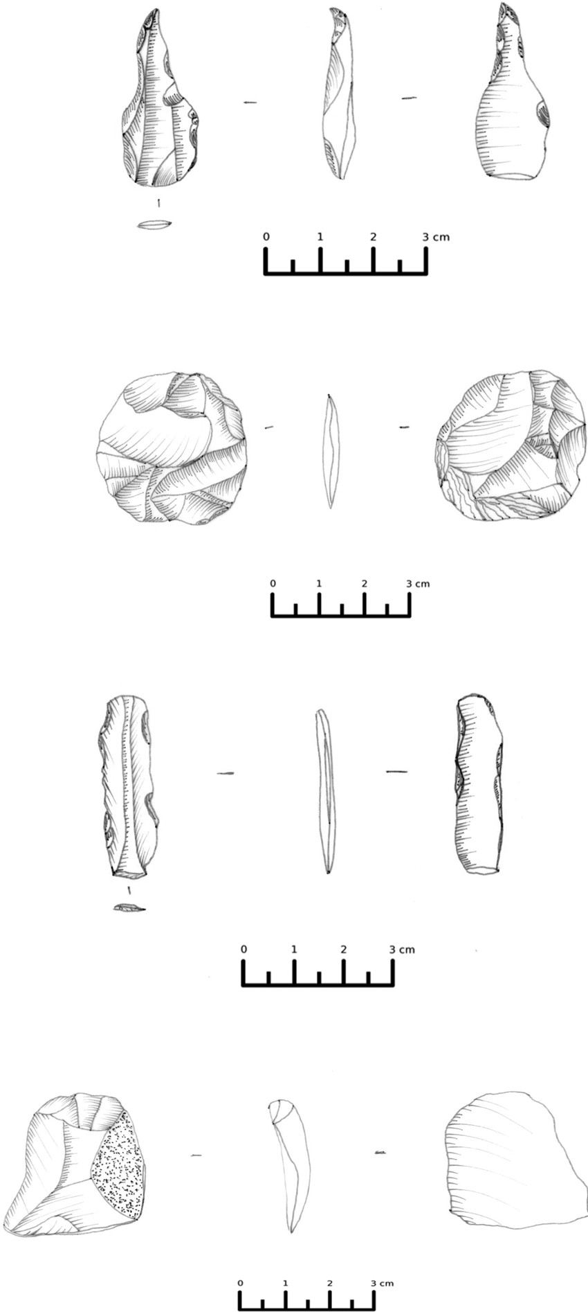
Fig. 8. Sample of lithic tools from the survey. Drawings by A. Psoma.
Metals
Although large quantities of slag were detected throughout the survey area, only one metal find can be attributed to the prehistoric phases with any degree of certainty. The artefact in question is a copper axe or adze collected from the surface at findspot 8/9 (Gourimadi). The object, approximately 10cm in length and probably produced by casting, was found in a nearly perfect state of preservation covered by a stable patina (Fig. 9). Stylistically, it belongs to Branigan's type III (Branigan Reference Branigan1974), with the earliest occurrence in the LN, although these kinds of axes continued to be produced until the end of the EBA. This dating fits well into the proposed FN/EBA I date for findspot 8/9 that is based on the pottery style and lithics. The dating is further supported by the scientific analysis of the object, conducted by colleagues from the Demokritos Institute (Mastrotheodoros et al. Reference Mastrotheodoros, Filippaki, Tankosić and Mavridis2019). The results of this analysis indicate that the axe was made of almost pure copper, suggesting that it predates the introduction of true (i.e. tin-alloyed) bronzes in the western Aegean at the end of the EBA (e.g. Nakou Reference Nakou1995, 15; Papadimitriou Reference Papadimitriou and Tzachili2008, 280).
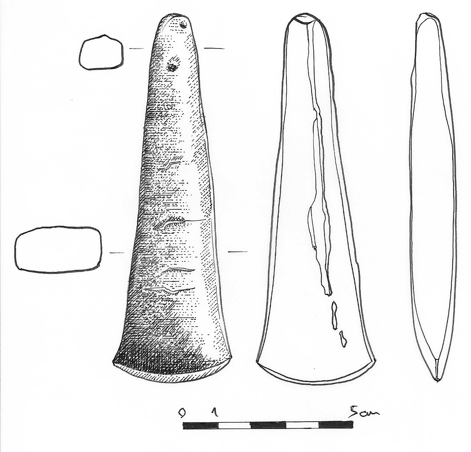
Fig. 9. Copper axe found at findspot 8/9 Gourimadi. Drawing by A. Djordjević.
Gourimadi (findspot 8/9)
Due to the potential recognised in the surface assemblage from findspot 8/9 (Gourimadi), this site became the subject of an independent excavation project (the Gourimadi Archaeological Project) that began in 2018 under the aegis of the Norwegian Institute at Athens. As of summer 2020, the project has opened four excavation trenches at the summit of the hill around which the surface artefacts were found in the largest concentration (Fig. 10).
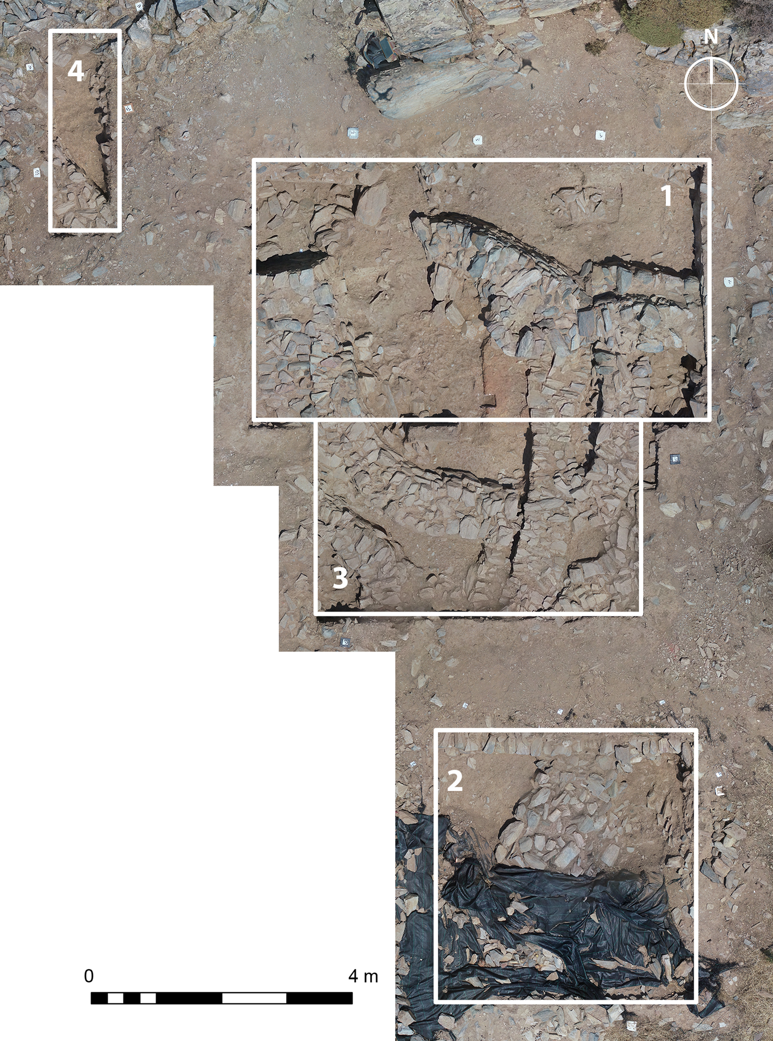
Fig. 10. Gourimadi trenches in 2020. Author: D. Nenova.
The excavation confirmed the existence of a substantial prehistoric site on this location, a likely settlement. The four trenches produced large quantities of obsidian, prehistoric ceramics that span at least three phases (LN through EBA I) and possibly also a fourth (EBA II), and substantial architectural remains consisting of both curved and straight walls and pits (Tankosić et al. Reference Tankosić, Mavridis, Zafeiriadis and Psomaforthcoming). A limited number of terracotta anthropomorphic figurines, ground stone tools, and stone-made ornaments complete the artefact assemblage. Animal bones were also encountered in smaller quantities, but it appears that the chemical composition of the soil is detrimental to bone preservation. Particularly significant is the identification of pottery that resembles the Saliagos-style ceramics, which was found at the Karystian Agia Triada cave (e.g. Mavridis Reference Mavridis, Tankosić, Mavridis and Kosma2017). Although the evidence currently consists of only several sherds, it is indicative of the presence of an earlier prehistoric phase in the Katsaronio plain that was not encountered among the surface remains. No evidence of metallurgical activities on the site has been found thus far.
SURVEY FINDS FROM THE HISTORICAL PERIODS
The survey located and recorded at least 39 confirmed findspots dated to historical periods (see Fig. 5). The findspots range in date mainly from Archaic to Late Roman, with only one example having a possible Byzantine date. There are at least another 10 findspots that are likely historical in date, judging by the general appearance of the ceramics found in these areas, but there was no way to confirm this as chronologically sensitive material was absent. Pottery is by far the most common artefact from findspots dated to historical periods. Metallic slag follows as the second most common material. Several large concentrations were recorded, the largest having been identified at findspot 18. Lithics found at historical sites are generally considered to be prehistoric, since none of them show evidence of re-use in historical contexts (e.g. as part of threshing sledges).
Pottery
The historical pottery provides critical information that helps to fill the gaps in the archaeological knowledge of the area. Although southern Euboea is represented in the bibliography of the Archaic, Classical, Hellenistic, and Roman pottery (Chatzidimitriou Reference Chatzidimitriou2003–4; Reference Chatzidimitriou and Mazarakis-Ainian2006; Reference Chatzidimitriou and Kazakou2011; Chidiroglou Reference Chidiroglou and Kazakou2011a; Reference Chidiroglou, Rupp and Tomlinson2011b; Reference Chidiroglou2012, 584–617; Reference Chidiroglou2014; Chidiroglou and Chatzidimitriou Reference Chidiroglou and Chatzidimitriou2006; Langridge-Noti Reference Langridge-Noti and Drougou2004; Moutsopoulos Reference Moutsopoulos1960; Rotroff Reference Rotroff, Rupp and Tomlinson2011; Wickens et al. Reference Wickens, Rotroff, Cullen, Talalay, Perlès and McCoy2018, 93–109), this additional material significantly improves our understanding of the region in terms of habitation patterns, commercial connections, and subsistence strategies. The survey collected more than 9000 historical sherds, from which a collection of about 4340 diagnostic sherds was analysed. This assemblage mainly includes fragments of bases, handles, and rims, while parts of bodies were collected only when they bore typologically or chronologically significant features. Those bearing glaze and/or various types of decoration complement the group. The vast majority of the diagnostic sherds are coarse wares (89.3 per cent), with fine wares accounting for 10.7 per cent. Individual sherds are identified in the text by their assigned inventory number (e.g. NASK 15 4036), where the first number represents the year in which the sherd was collected and the second is an arbitrary consecutive number. The findspot number and toponym are added for further clarification.
Vessel shapes
Vessel shape can be identified (with any degree of certainty) for only 1168 diagnostic sherds from the Archaic, Classical, Hellenistic, and Roman periods. This is due largely to the poor preservation of the sherds, which in many cases makes even the identification of potter's wheel traces impossible. This leaves the examination of the fabric the sole factor for distinguishing between prehistoric and historic sherds. NASK14 1454 (findspot 76, Ag. Nikolaos 2) (Fig. 11a) is an instructive example of the usual state of preservation: the entire glaze on the sherd is fugitive, while only shallow traces of the rouletting decoration are preserved.
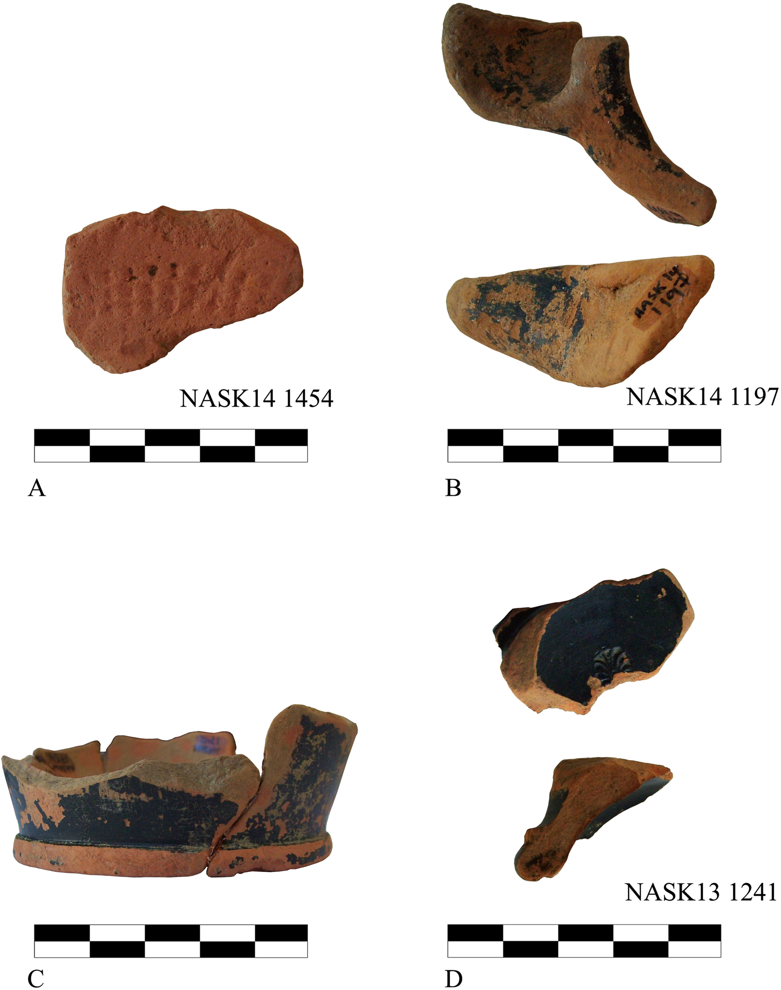
Fig. 11. Fragments of (a) plate with rouletting decoration, (b) lamp, (c) Attic-type skyphos, and (d) Classical-type kantharos. Photos by A. Laftsidis.
The pithos is the most common shape among the coarse wares, a fact to be partly explained by the higher visibility of and greater degree of survival of this type of pottery (Fig. 12). Most of these sherds are rim fragments, though a large number also come from bases. Body fragments are also common, often bearing decoration consisting of plastic rings. The second most common shape is the trade amphora. Most of the amphorae are easily recognisable by their distinctive handles, which form the majority of this shape's fragments. There are, however, several examples from their pointed ends, and some – though much fewer in number – from the neck. Body and handle sherds of Roman-period trade amphorae form a small group, easily identifiable from their distinctively hard-fired fabric. Furthermore, there are numerous fragments of lekanai, which almost exclusively come from the upper part of the body and the rim, and which represent several different types of this shape. The next most common shape is the hydriai; the majority of these are represented by parts of handles (either horizontal or vertical), and there are also a few fragments from the shoulder, neck, and rim of the vase. Jugs are identified most frequently by vertical strap handles, but fragments from the rim are also present in much lower frequency. Finally, there are many examples of cooking vessels, particularly small and large chytrai with either one or two handles, and there are also a few examples of lopades. These vessels are most often recognised by their distinctive rims and handles and their gritty fabric, which contains many inclusions. Additional coarse ware shapes occur in considerably fewer numbers, including storage vessels, lagynoi, mortars, plates, small bowls, and a single lamp.

Fig. 12. Representation of coarse ware shapes from historic periods. Chart by A. Laftsidis.
An equally large variety of shapes is observed among the fine wares, despite their significantly smaller number in comparison with the coarse wares (Fig. 13). The prevalence of drinking vessels is evident, accounting for 65 per cent of the total number of fine wares. The most numerous is the skyphos of the Attic type, with 18 examples. Almost all of these fragments come from the base and lower part of the body. There are also plentiful handle fragments of bolsals and/or one-handlers – although the function of the latter as either drinking cups or food bowls is debatable (Rotroff Reference Rotroff1997, 155), and most possibly their use could vary depending on the occasion. However, a definitive identification with any of these shapes is difficult due to the sherds’ fragmentary state of preservation. Furthermore, nine examples of the skyphos of the Corinthian type are present, similarly coming from the distinctive lower part of that shape and characterised by a flaring foot and a strongly upward body. Kylikes can also be seen, though in only four examples; these are identified by pieces coming from the high swung handles and the base. In addition, there are five examples of kantharoi, which are easily identified through their distinct moulded bases and spur handles, typical for kantharoi of the classical type. A small part of a handle (NASK15 4036, findspot 106, Ag. Antonios), however, speaks to the presence of the kantharos type with swung handles. One example of a bowl-kantharos is also present. A parabolic cup (mastos) completes the group of drinking vessels. It is notable that there are only two examples of small handleless bowls (NASK14 0397 and NASK13 1255, found outside of recorded findspots), which are typically among the most common fine ware shapes in pottery assemblages especially from the Hellenistic period onwards (Rotroff Reference Rotroff1997, 156 nn. 38–40; Laftsidis Reference Laftsidis2018, 726–37). In contrast, eight fragments come from kraters, most of which are from handles, but also from bases and one that preserves part of the rim of a calyx-krater. Other fine ware shapes that can be identified in smaller numbers include amphorae, hydriai, plates, deep bowls, lekanides, oinochoai, lamps, and a single fragment of a lekythos.

Fig. 13. Representation of fine ware shapes from historic periods. Chart by A. Laftsidis.
Fabrics and decoration
Several different fabrics are present in the assemblage. The most common type among the coarse wares is a plain reddish fabric with many schist-like inclusions and abundant mica. The colour is usually reddish yellow (Munsell 5YR 6/8, 5YR 7/8, or 7.5YR 8/6). Pithoi and cooking vessels, on the other hand, tend to have a coarse reddish fabric with more schist-like inclusions and mica, many grits, and often many small grinds of roof tiles (grog), which together form a much more resilient fabric. This fabric colour is usually also reddish yellow (5YR 6/8, 5YR 7/8, or 7.5YR 8/6), while the core often has a different colour ranging from white (7.5YR 8/1) to light grey (7.5YR 7/1). The clay of both fabrics is usually brittle, likely a result of the firing conditions. Both of these fabrics were observed in the pottery from the Bouros-Kastri peninsula (characterised there as Plain Red Fabric [PRF] and Coarse Red Fabric [CRF]), although the colour of the clay recorded in that case does not seem to correspond directly to the one stated above. However, the fact that the Bouros-Kastri types are interpreted as most likely local (based on their abundant presence in the nearby kiln site of Akrotiri) could point to a local origin for the fabrics considered here as well (Wickens et al. Reference Wickens, Rotroff, Cullen, Talalay, Perlès and McCoy2018, 93–4). A few Roman amphorae represent a third fabric type which is very hard-fired and reddish yellow in colour (5YR 6/8–7/8), and includes a modest quantity of shiny particles and white inclusions (possibly quartzite).
The fabric of the fine wares is almost devoid of inclusions, with at times only a small amount of mica. The colour of the clay can vary, but in most cases it falls within different tones of reddish yellow (5YR 7/8 or 7.5YR 7/8), with some examples of pink (5YR 8/3 or 5YR 8/4). All the fine wares (about 75 in number) bear glaze, which is usually fugitive. When still preserved, it is usually shiny black or, less frequently, dull black. Only in a handful of examples is the glaze brown in colour. Assigning a place of origin to them is not easy, but three are most probably Attic (Fig. 11cd). The possibility of a local origin for some of the fine wares should not be excluded, since local pottery production in the area of Karystos has already been verified (Chatzidimitriou Reference Chatzidimitriou and Mazarakis-Ainian2006, 1070; Reference Chatzidimitriou and Kazakou2011). Lastly, a red (2.5YR 5/8) hard-fired fabric with some lime inclusions and voids is attested and can be attributed to the much later Incised Sgraffito Ware, which is mentioned below.
Only a small number of sherds bear any kind of decoration (4.9 per cent of the total collected historic sherds). Among these, several different decorative techniques can be identified. The most frequent, found on pithoi and less frequently on lekanai, consists of plastic rings. In the first case, they surround the vase at the transition from the base to the body, in the middle of the body, or at the transition to the rim. In the case of lekanai, they are found only below the rim. Another type of decoration consists of multiple parallel horizontal incised lines that surround the vase, usually some distance below the rim. Surprisingly, relief decoration, often combined with incision, appears 11 times on sherds deriving from pithoi (Fig. 14). These sherds mostly come from raised panels in the body, probably helping the transition between separately made parts of the vessels, while at the same time better ensuring their cohesion. In one case, however, the decorated fragment derives from the rim of a vase. There is a relative variety of non-figured patterns, consisting mostly of tongue motifs and palmettes (NASK14 1114 and NASK14 1140, from findspot 67, Oikopedo Spasis), single guilloche (NASK14 1121 and NASK13 0007 from 67 and 13–23,Footnote 2 Oikopedo Spasis and Ag. Petros and Pavlos, respectively), and Ionic cyma (NASK14 1201, findspot 67). This type of decoration on pithoi is not uncommon for the area. Similar examples have been found in Karystos, as well as at the neighbouring sites of Filagra and Zarakes.Footnote 3 Rope decoration is found on only one sherd (NASK12 0084 from findspot 08/09, Gourimadi), which probably belongs to a pithoid vase. Stamped decoration appears twice: kantharos NASK13 1241 (findspot 43, Xokklisi) preserves one stamped palmette on its bottom (Fig. 11d), and the bowl NASK14 0397 has traces of two palmettes, in this case surrounded by rouletting. The rouletting decoration can also be seen on the plate fragment NASK14 1454 (findspot 76, Ag. Nikolaos 2), though it is impossible to say whether it was accompanied by stamped decoration due to the state of preservation (Fig. 11a).
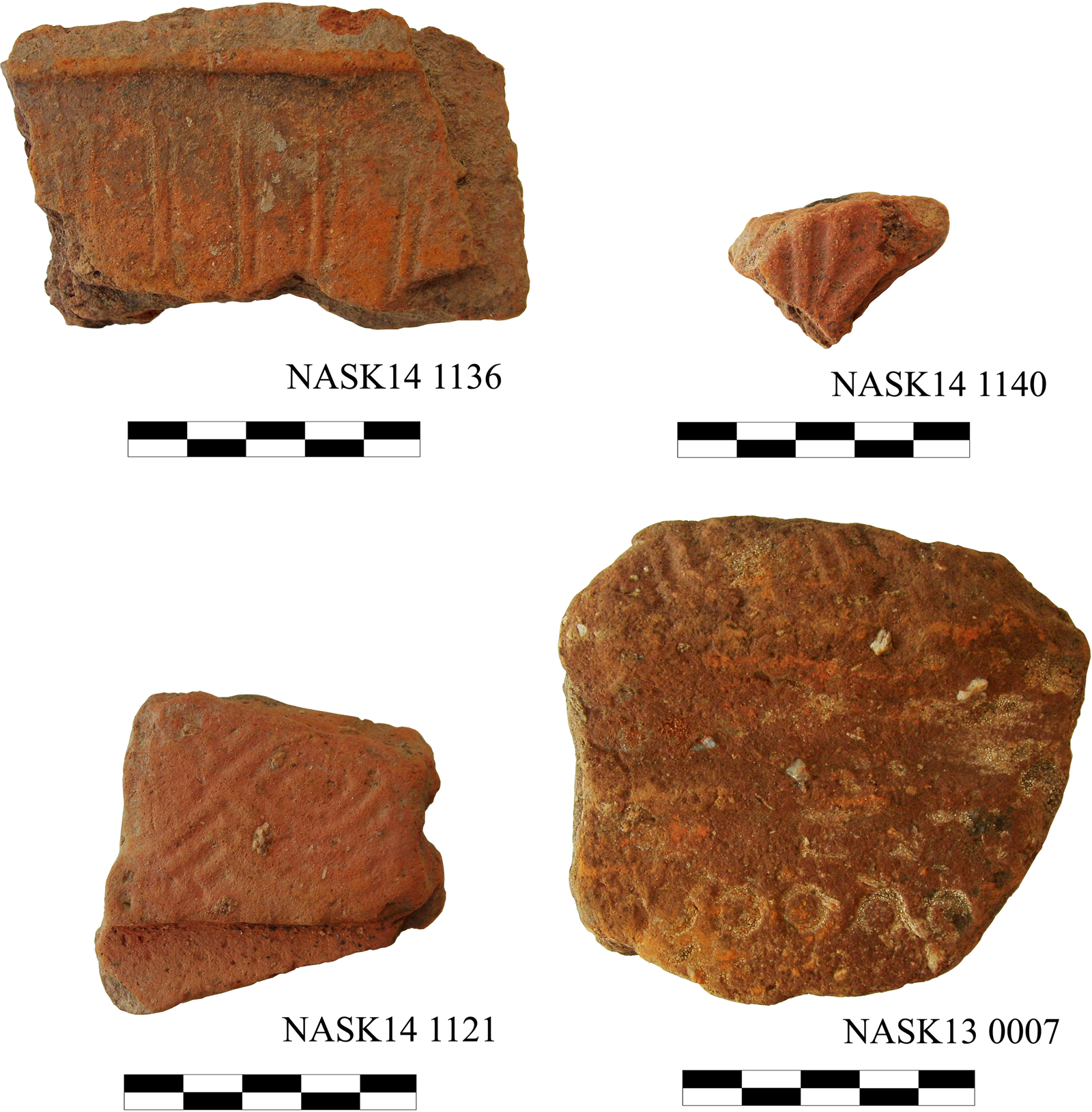
Fig. 14. Relief decorated pithoi. Photos by A. Laftsidis.
A very distinct type of decoration, appearing in the assemblage only once, is modelling in the form of an ivy-leaf thumb rest which decorated the upper part of the strap handle of the bowl-kantharos NASK13 1083 (findspot 44, Ag. Taxiarches) (Fig. 15c). There is only one example of possible red-figure decoration: krater rim NASK14 1749 (findspot 77, Mantra), on which the outline of possible laurel leaves is preserved (Fig. 16a). Burnished decoration is found in a single instance (NASK13 0502; findspot 35, Ag. Thimotheos and Mavra) and consists of several thin radial lines starting from the lower part of the vase, possibly a bowl. Finally, there is a single stamped handle of a trade amphora (NASK14 0530, findspot 67); it is broken precisely at the beginning of the sealing, making the recognition of the decorative motif difficult, but a tripod identification seems very possible (Fig. 16b).

Fig. 15. (a) Fragments of a parabolic cup, (b) Attic-type skyphos, (c) bowl-kantharos, and (d) mortar. Photos by A. Laftsidis.

Fig. 16. Fragments of (a) red-figure krater and (b) stamped amphora handle. Photos by A. Laftsidis.
Datable examples
To date such fragmentarily preserved material with precision is a difficult task. This is particularly true for the pithoi, the most numerous category (27.2 per cent of all the diagnostic historical pottery). Aside from being preserved only as sherds, according to Giannopoulou (Reference Giannopoulou, Papanikola-Bakirtzi and Kousoulakou2010, 66–7) they retained the same form over time, and no true technological differences can be seen in their way of production. Any precise dating is thus very difficult. Rotroff, on the other hand, presents a typological organisation of the material from the Bouros-Kastri survey based on the form of the rims and the presence (or not) of necks. A generic chronology is assigned to these types on the basis of similarly shaped examples found elsewhere and on other chronological indicators found at the same findspots as the pithoi fragments (Wickens et al. Reference Wickens, Rotroff, Cullen, Talalay, Perlès and McCoy2018, 105–7). We focus here on the pithos fragments which offer more readily accessible chronological evidence, as well as some of the more important sherds from other types of vessels.
The earliest dated group of sherds concerns 11 sherds of pithoi that bear relief and incised decoration (see Fig. 14). They are a rare exception to the general challenge of dating pithoi. Based on comparisons with other similar examples from the Aegean area, we can place them in the period spanning from the late seventh to the early fifth century bce (Chidiroglou Reference Chidiroglou2012, 597 n. 2627). It is true that a few isolated examples from Attica or the Aegean area can be dated even deeper into the fifth century bce because of their inclusion in later deposits, but the possibility cannot be excluded that at the time of their last use they were already several generations old.Footnote 4 Further, the coexistence of relief Archaic pithoi and Hellenistic period pottery has been noted in several areas of eastern Crete (Englezou Reference Englezou and Drougou2000, 62 n. 9; Whitley Reference Whitley, Nevett and Whitley2018, 62–3, fig. 4:3).
Second comes a fragment of a black-glazed lamp NASK14 1197 from findspot 67 (Oikopedo Spasis) (Fig. 11b). The narrow nozzle, which is set too close to the body, and the extremely large filling-hole that occupies most of the upper part, place the lamp in Howland's Type 16 B. Its particular morphological features, such as the narrow rim, date it to the last quarter of the sixth century bce (Howland Reference Howland1958, 31–2 n. 94, pls 4 and 32).
The most numerous fine ware shape, the skyphos of the Attic type, offers several more datable examples. The best preserved is a skyphos from findspot 77 (Mantra) consisting of the joining fragments NASK14 1742, 1754, 1741, 1752 and 1745, while the fragment NASK14 1751 belonged to the same vase, though it cannot be joined with the others (Fig. 11c). Its form, despite being fragmentarily preserved, places it around 400 bce. Even though the wide torus ring foot comprises an element of an early date, the straight profile of the lower part of the body with diagonal upward direction reveals that the vase belongs to a next, middle stage of the shape's development.Footnote 5
Kantharos fragment NASK13 1241 (findspot 43, Xokklisi) is one of the most important examples for dating purposes (Fig. 11d). Its profile and, most importantly, the stamped palmette on its floor constitute critical chronological features that place it before 325 bce; according to Rotroff (Reference Rotroff1997, 37) that shape was not stamped after that time. Furthermore, the form of the base and the height and profile of the stem put it close to examples from the Athenian Agora, which are dated to the third quarter of the fourth century bce (Sparkes and Talcott Reference Sparkes and Talcott1970, 286 n. 700, fig. 7). Another datable kantharos fragment (NASK15 4032 from findspot 106, Ag. Antonios) is placed slightly later, in the last quarter of the fourth century bce. This date is indicated by the form of the moulded base and the narrow, slightly elongated stem (Sparkes and Talcott Reference Sparkes and Talcott1970, 283, no. 662, 287, no. 714).
Fragment NASK14 0223 (findspot 51, Dyo Aloga) from a parabolic cup (mastos) must be placed in a slightly later period (Fig. 15a). It finds a close parallel in the mastos Z21 from Tomb Z at Derveni, Macedonia, which is dated to the transition from the fourth to the third century bce (Themelis and Touratsoglou Reference Themelis and Touratsoglou1997, 121, 125, no. Z21, pl. 139). Its best comparanda, though, are a mastos from Messene, which is placed in the early third century bce (Themelis Reference Themelis and Drougou2000, 412–13, pl. 186a), and another from Keryneia, Achaea (Dekoulakou Reference Dekoulakou2011, pl. 1d). The only elements that set them apart are the absence of a nipple in our example, as well as the straighter profile of the body. It is not possible to establish whether these elements constitute chronological criteria.
A fragment from the base and lower body of a skyphos of the Attic type (NASK15 4025; findspot 106, Ag. Antonios) can be placed at about the same time (325–275 bce; Fig. 15b). This date is indicated by the narrow torus ring foot and the almost vertical lower part of the body (cf. Rotroff Reference Rotroff1997, 257–8 nn. 151–2, fig. 12, pl. 14).
NASK13 1083 (findspot 44, Ag. Taxiarches), which derives probably from a bowl-kantharos (Fig. 15c), appears to be slightly later. It is comparable to an example from the Athenian Agora dated to the second quarter of the third century bce (Rotroff Reference Rotroff1997, 257 n. 148, fig. 12, pl. 14). Even though a dating exclusively based only on the form of the handle is far from secure, its placement in the third century bce seems quite safe, since almost all of the examples of this Hellenistic type of bowl-kantharos belong in this century (Rotroff Reference Rotroff1997, 934).
Another vase that can offer some chronological evidence is NASK14 2062 (findspot 90, Ag. Nikolaos 1) (Fig. 15d). It is part of a mortar, which is also the best-preserved fragment in the collection and the only one that retains its entire profile. Despite the undeniable fact that coarse wares are much more difficult to date than fine wares, this fragment offers a wide chronological frame. The lack of a ridge at the inner edge, as well as of the distinctive piecrust handles, categorises it under the Classical type of the shape, which was still in use in the second half of the fourth century bce, while it can also sometimes be found in contexts belonging to the early third century bce (Rotroff Reference Rotroff2006, 101 n. 139).
A relatively small number of sherds can be assigned to the Roman period. A precise dating can be determined for even fewer, as most of them come from locally made and difficult-to-classify vessels. Nevertheless, some of them, such as NASK14 0042 from findspot 48 (Ag. Ioannis) (Fig. 17a) could belong to eastern sigillata C (ESC) ware or locally made imitations, dating to the second or third centuries ce (Hayes Reference Hayes1972, 321–2, type 4). The amphorae sherds NASK14 0230 and 1253 from findspots 51 and 68 (Dyo Aloga and Paradeisi 1, respectively) (Fig. 17bc) are also of interest. Their heavy, round-sectioned and ribbed handles, with their reddish yellow fabric, places them under the amphora type identified at Benghazi as Middle Roman 5 or Zeest 80, a type with a widespread distribution in the Aegean and Black sea regions and generally dated to the second and third centuries ce (Riley Reference Riley and Lloyd1979, 188–9).
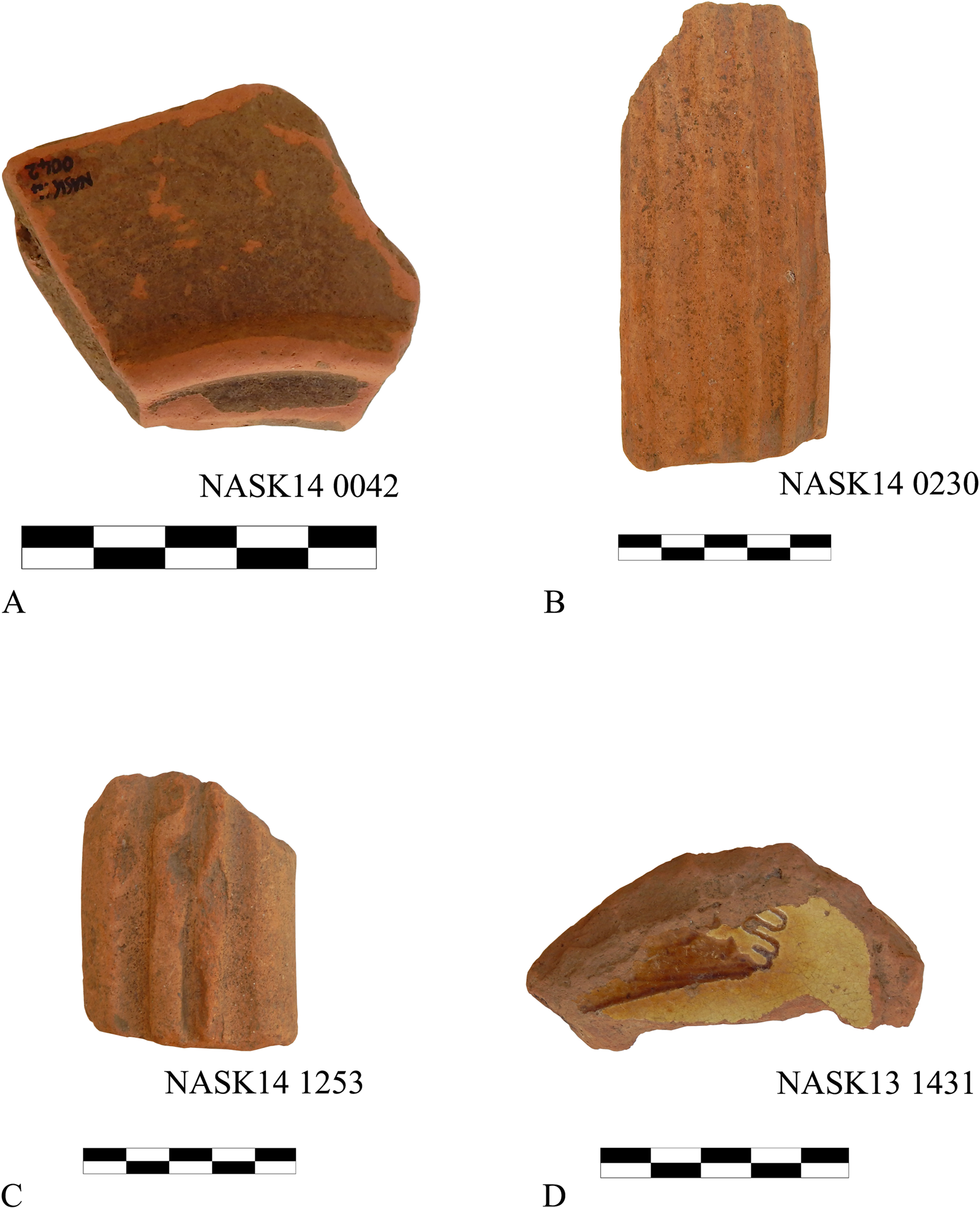
Fig. 17. Fragments of (a) an eastern sigillata C (ESC) ware, (b–c) type Zeest 80 amphorae, and (d) an Incised Sgraffito Ware. Photos by A. Garyfallopoulos.
Finally, as far as the Byzantine period is concerned, only one sherd (NASK13 1431, findspot 44, Ag. Taxiarches) can provide us with chronological indications (Fig. 17d). This sherd has a characteristic red, hard-fired fabric with lime inclusions and voids, the application of white slip (both on the interior and exterior surface), and a yellowish glaze on the interior surface. These features place it under the Incised Sgraffito Ware category, with a possible date in the second half of the twelfth or the early part of the thirteenth century ce (Morgan Reference Morgan1942, 146–57; Vroom Reference Vroom2005, 91).
While it is difficult to draw definite conclusions based on this assemblage, it seems that most of the material can be placed in the Classical period and, more specifically, in the late fifth and fourth centuries bce (Fig. 18). This conclusion is in accordance with the small number of handleless bowls. From the Hellenistic period onwards, handleless bowls are usually the most abundant category of vases found in both residential and funerary contexts; handleless bowls are not, however, as common before the late fifth century bce (Sparkes and Talcott Reference Sparkes and Talcott1970, 128). If this image is not simply coincidental or a result of preservation bias, it could indicate the expansion of habitation during the late fifth to early fourth century bce and, possibly, the increase in population in the areas under investigation.

Fig. 18. Spatial and temporal distribution of dated vases/sherds from historic periods. Chart by A. Laftsidis.
Summary of the historical pottery
The historical pottery not only gives us the opportunity to complement the archaeological map of the Karystia, but it also provides us with important information about habitation patterns, local economy, and commercial connections, about which some preliminary remarks are made here. In all but one case, the findspots should be interpreted as sites with residential aspects. This conclusion stems from the enumeration of the identified shapes, which include pithoi, storage vessels, trade amphorae and cooking vessels, as well as fine wares. Most of the above shapes could also be found in funerary contexts; however, their high percentages do not support such a view. The only shape that could be associated with higher probability with a cemetery is the lekythos fragment NASK15 3086 from findspot 12–23 (Ag. Isidoros) (Fig. 19). Lekythoi, however, are often found in residential contexts as well, such as various types of lekythoi from the Athenian Agora (see Sparkes and Talcott Reference Sparkes and Talcott1970, 150–5 nn. 1097–146, fig. 11, pls 38 and 48), so the existence of a cemetery at this location in the Katsaronio cannot be ascertained with certainty.

Fig. 19. Lekythos fragment (NASK15 3086). Photo by A. Laftsidis.
It is noteworthy that pithoi comprise a very large percentage (almost one third) of the coarse wares. This fact may imply the existence of several farms or settlements with extended storage facilities. It also underlines the agricultural production capabilities of these communities, as these containers usually held grain and wine. The indication of production activities is further emphasised by the discovery of other objects, such as five collected fragments of wine presses, with several additional elements also left in situ, as they were too large to transport. Furthermore, the identification of two fragments of kiln furniture – a teardrop-shaped support (NASK13 0676) and a stacking ring (NASK 13 6890) – indicates the presence of local pottery workshops.Footnote 6
Last but not least, the extremely high percentage of fragments of trade amphorae (21.4 per cent of the coarse wares) demonstrates the degree to which the area was involved in commercial activities. Due to the fragmentary state of the material and the fact that most of the trade amphorae are identified only through their handles, it is difficult to identify an area of origin for these vessels. A fortunate exception is the stamped handle NASK14 0530 (Fig. 16b) from Oikopedo Spasis (findspot 67), whose origin was the island of Thasos, in the northern Aegean. Trade connections with the northern Aegean or the Black Sea area are attested, furthermore, by the Benghazi Middle Roman 5 or Zeest 80 type amphorae (NASK14 0230, 1253), a type linked to those regions. The type was identified in Karystia itself, in the nearby Bouros-Kastri peninsula (Wickens et al. Reference Wickens, Rotroff, Cullen, Talalay, Perlès and McCoy2018, 218) and, recently, in significant quantities in Dion, Macedonia (Fragoulis, Minasidis and Mentzos Reference Fragoulis, Minasidis, Mentzos, Poulou-Papadimitriou, Nodarou and Kilikoglou2014, 298, figs 6–7).
As far as the fine wares are concerned, the Athenian origin of several vessels seems possible. This is corroborated by the reddish yellow inclusion-free clay of many of the examples, as well as their shiny black glaze, whenever it is preserved. This is the case, for instance, with the kantharos fragment NASK13 1241. To pinpoint the origin of these vessels with any degree of certainty, petrographic analysis must be undertaken. It is noteworthy that the close connection between Athens and the Karystia has been observed in the case of cooking wares and some coarse wares (e.g. Rotroff Reference Rotroff, Rupp and Tomlinson2011, 179; Wickens et al. Reference Wickens, Rotroff, Cullen, Talalay, Perlès and McCoy2018, 94), as well as by the abundance of products from the Athenian kerameikos found in two cemeteries in the area, one in Karystos (the Papachatzis’ plot; Chidiroglou Reference Chidiroglou, Rupp and Tomlinson2011b) and one found west of the modern town (Chatzidimitriou Reference Chatzidimitriou and Mazarakis-Ainian2006, 1067–71). Finally, the abovementioned example of Incised Sgraffito Ware (NASK13 1431) appears also to be imported from elsewhere in the Aegean (Morgan Reference Morgan1942, 146–57; Vroom Reference Vroom2005, 91).
Finally, in spatial terms, it is apparent that findspots datable to historic periods tend to cluster in the central, northern, and north-eastern sections of the Katsaronio plain (Fig. 5). This roughly mirrors the modern distribution of settlements and agricultural fields, suggesting a relatively consistent habitation/use pattern. The weather conditions are surely at least partly the reason for this, as those areas are more sheltered from the prevailing strong north-easterly winds, the intensity of which can be particularly abrasive along the southern edges of the plain. In addition, the main water sources can be found in the upper two thirds of the Katsaronio, which makes this area more suitable for agriculture, whereas the southern third could have been used in the past chiefly for husbandry (as is the case today), an activity which would have left fewer material traces.
Metals
Large amounts of slag were found throughout the survey area, often in concentrations associated with specific findspots, but also as off-site scatter (Fig. 20). This material is currently under study by Ole F. Nordland from University College London. Based on preliminary analysis, the most frequently encountered type of slag is tap slag, followed by furnace and smithing slags (O.F. Nordland, pers. comm.). The largest concentration of slag was encountered at findspot 18 where, based on slag and burnt soil distribution, we were able to identify the existence of at least six distinct furnaces. We also identified some technical ceramics used in metallurgy (e.g. furnace lining, crucibles, blowpipes). Findspots 44 and 106 also produced evidence of substantial metallurgical activities, and we recorded an abandoned iron mine (findspot 27), which according to locally obtained information was exploited in modern times.
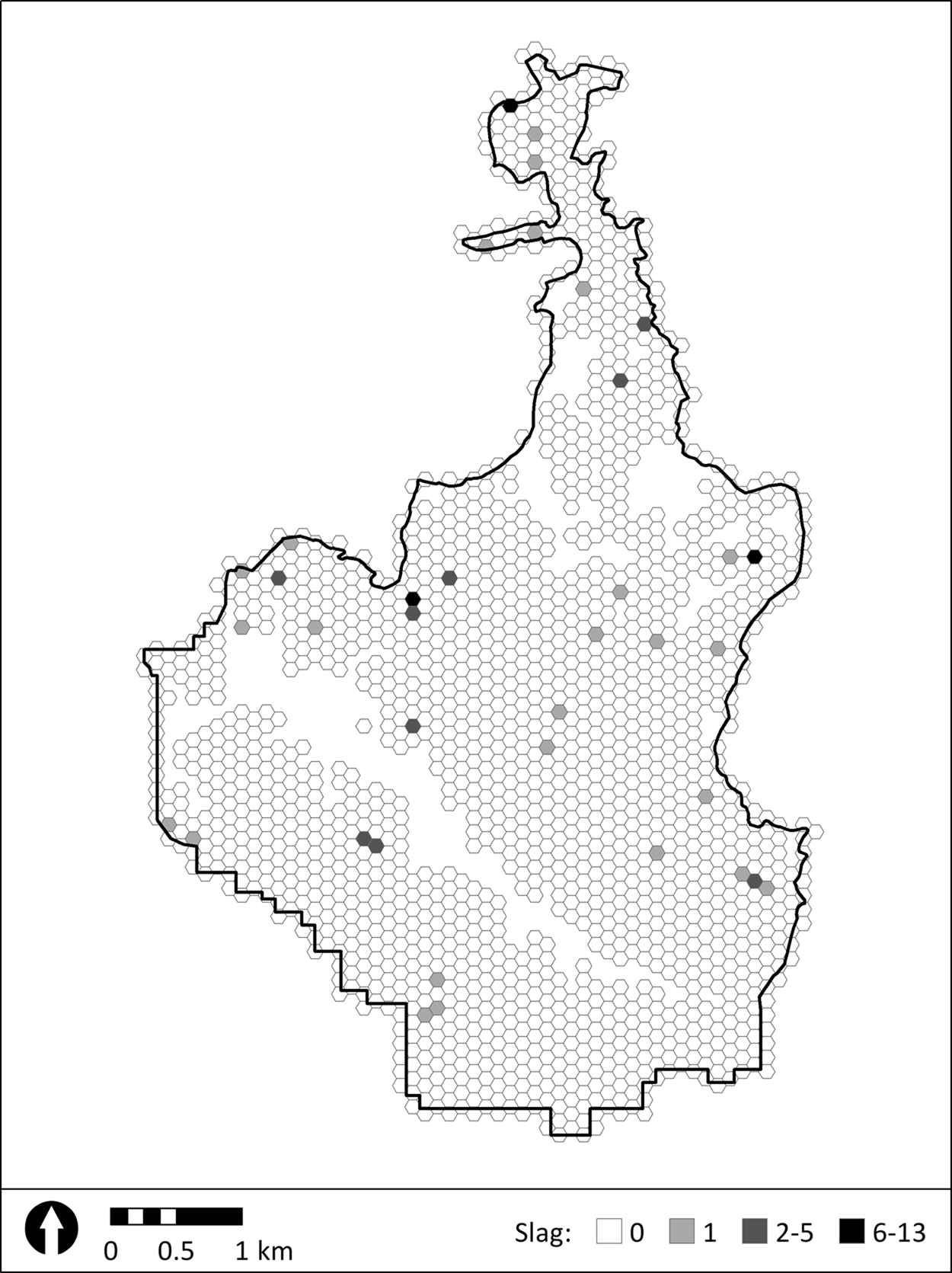
Fig. 20. Distribution of off-site slag collected during transect survey, generalised in 1-ha tessellations. Finds collected during intensive findspot survey are not shown. Unsurveyed areas are absent of tessellations. Map by R.M. Seifried.
Most of the slag found during the survey appears to be of post-prehistoric date, as macroscopic assessment suggests it is a by-product of iron-based metallurgy. This interpretation is supported by the occasional discovery of slag at findspots where Classical and Hellenistic pottery were dominant. Unfortunately, we are unable to date the largest slag concentration at findspot 18. We encountered no datable material there whatsoever, despite repeated revisitations. Samples for thermoluminescence dating have been collected but not yet analysed.
DISCUSSION
The results of NASK allow us to offer some tentative interpretations of the diachronic nature of the human exploitation and structuring of the landscape in this section of the Aegean. The data point to the Katsaronio plain as an actively lived-in and exploited landscape from at least the late fifth millennium bce up until modern times. This occupation and use, however, does not appear to have been continuous. There are some gaps in the surface record that are difficult to explain as a consequence of survey methods, especially since they are comparable to data from elsewhere in southern Euboea.
Despite our expectations, we did not encounter any surface material that was unambiguously older than the FN phase, leading us initially to conclude that the LN phase is absent from the Karystia, with the exception of the Agia Triada cave (Mavridis Reference Mavridis, Tankosić, Mavridis and Kosma2017; Mavridis and Tankosić Reference Mavridis, Tankosić and Tsirtsoni2016a). This conclusion, however, needs to be modified under the weight of (albeit limited) evidence from the Gourimadi excavation, which suggests that the finds from the LN phase might be obscured by later human activities or geological processes in the Katsaronio. The post-EBA II prehistoric phases (EBA III, Middle and Late Bronze Age) are also missing from the surface assemblage. Even the very end of the EBA II, the EBA IIB Lefkandi I/Kastri phase (e.g. Renfrew Reference Renfrew and Kline2010, 89; Rutter Reference Rutter1979; Wilson Reference Wilson1999, 95) is absent from the record. This situation mirrors data from surface surveys conducted elsewhere in the Karystia (Cullen, Talalay and Tankosić Reference Cullen, Talalay, Tankosić, Rupp and Tomlinson2011; Cullen et al. Reference Cullen, Talalay, Keller, Karimali and Farrand2013; Keller Reference Keller1985; Tankosić and Chidiroglou Reference Tankosić and Chidiroglou2010; Wickens Reference Wickens, Rupp and Tomlinson2011; Wickens et al. Reference Wickens, Rotroff, Cullen, Talalay, Perlès and McCoy2018) and from the limited number of excavated prehistoric sites (K. Boukaras, pers. comm.; Crielaard and Songu Reference Crielaard, Songu, Tankosić, Mavridis and Kosma2017; Mavridis and Tankosić Reference Mavridis and Tankosić2016b; Sapouna-Sakellaraki Reference Sapouna-Sakellaraki1992; Tankosić et al. Reference Tankosić, Mavridis, Zafeiriadis and Psomaforthcoming). Together the results of this work suggests that the entire Karystia could have been severely depopulated during those particular prehistoric phases, or that population centres (cf. Tankosić and Mathioudaki Reference Tankosić and Mathioudaki2011) were located outside the areas hitherto targeted by intensive archaeological survey, such as in the rugged and mountainous central and northern parts of the Bouros-Kastri peninsula. The results of the recently completed archaeological survey conducted in that part of the Karystia under the aegis of the Netherlands Institute at Athens might contribute to changing this perspective.
The Sub-Mycenaean phase is scarcely attested in southern Euboea. There is solid evidence for Iron Age activities, although localised at the north-western part of Karystos bay at the site of Plakari (Crielaard and Songu Reference Crielaard, Songu, Tankosić, Mavridis and Kosma2017). We found no contemporaneous material in the Katsaronio plain, suggesting that either the human activity during this period was centred on the part of the Karystia located closer to the sea or that the material dated to this phase is difficult to separate conclusively from that of other phases.
The Katsaronio plain re-emerges in the archaeological record in connection with the Archaic period, albeit barely, and it seems to have been continuously inhabited ever since, with varying intensity. Archaic evidence is present but scarce in the rest of southern Euboea, too (e.g. Charalambidou Reference Charalambidou, Tankosić, Mavridis and Kosma2017; Crielaard and Songu Reference Crielaard, Songu, Tankosić, Mavridis and Kosma2017; Seifried and Parkinson Reference Seifried and Parkinson2014). The strongest evidence for human activity in the Katsaronio comes from the Classical period and continues into the Hellenistic. Roman and Byzantine activity is also attested, although not with the same intensity. These later historical developments contrast with the other large agricultural area in the Karystia, the Kampos plain, which saw the greatest amount of human activity during the transition from the Roman to the Early Byzantine times (Tankosić and Chidiroglou Reference Tankosić and Chidiroglou2010). At the same time, the Katsaronio developments are similar to those in an agriculturally marginal section of the Karystia, the Bouros-Kastri peninsula, where a decrease in human activity is observed from the Middle Hellenistic through the Roman period, with some improvement during Late Roman times, and with almost no pre-middle Byzantine evidence (Wickens et al. Reference Wickens, Rotroff, Cullen, Talalay, Perlès and McCoy2018, 112–14).
A salient characteristic of the Katsaronio archaeological evidence seems to be its connection to activities related to agriculture and husbandry. This is to be expected, as the plain is arguably the section of southern Euboea best suited for agriculture. Agricultural and husbandry activities are reflected, in Classical and Hellenistic times particularly, in the abundance of remains of large storage vessels and, during the prehistoric times, in the apparently deliberate avoidance of major habitation in the plain itself, presumably to maximise yields during the times when extensive agricultural practices were used (Tankosić and Katsianis Reference Tankosić, Katsianis, Sarris, Kalogiropoulou, Kalayci and Karimali2017).
The fact that activities other than agriculture and animal husbandry were also practiced in the area can be seen in the presence of prehistoric metal objects, as well as stone quarries and massive amounts of slag at several locations throughout the area, most of which are likely connected to the historical periods. The substantial amount of obsidian tools and debitage, found in prehistoric contexts both on- and off-site, and the large number of obsidian arrowheads at findspot 8/9 (Gourimadi), testify to the complexity of human activities in this particular section of the Aegean landscape. Findspots 8/9 (Gourimadi), 21/22 (Dexameni), and 2/4 (Choni), which are scattered along the defensible south-western ridge of the valley, evince intensive manufacturing that could, in turn, elevate these sites to significant waypoints in the local obsidian trade network, where raw material could have been prepared prior to distribution. Their strategic location, combined with a large number of arrowheads (at findspot 8/9) could even be seen as indicators of conflict or warfare, although this hypothesis is hard to substantiate using existing evidence and can only be addressed through future excavations. Whatever the case, long-range connections between the people living in the Katsaronio plain and the wider Aegean are well established in the region's prehistory through the presence of Melian obsidian and copper objects, the raw materials for which must (in the case of obsidian) or could (copper) have been obtained through maritime contact. These connections continue – and intensify – in later periods as well, judging by the presence of Classical trade amphorae (one of which is possibly identifiable as coming from the northern Aegean island of Thasos) and amphorae from the Roman period. This reflects the known historic connections between the people from the Karystia and their contemporaries elsewhere in the Mediterranean (e.g. Chidiroglou Reference Chidiroglou, Tankosić, Mavridis and Kosma2017).
When placed in the wider southern Euboean context, there are perceptible differences and similarities in the ways that the Katsaronio plain was exploited which may have their basis in the geomorphological properties of its soils, its location, and also in the shifting socio-political environment. For example, the patterning of the extant prehistoric evidence is in many ways similar with the rest of the Karystia, where most lowland findspots consist only of lithics. The same pattern is seen in the Kampos, for example. Conversely, most of the findspots with lithics and pottery – and, in some rare cases, architectural remains – tend to be placed in more rugged sections of the landscape or closer to the sea (Tankosić and Katsianis Reference Tankosić, Katsianis, Sarris, Kalogiropoulou, Kalayci and Karimali2017). The absence of surface evidence in the Katsaronio for the post-EBA prehistoric presence, with Agios Nikolaos as the only current Karystian exception, is also comparable with the rest of southern Euboea.
The situation diverges when we enter the historical phases. There is a scarce Archaic presence throughout the Karystia, but the intensity of exploitation during the Classical through Early Byzantine times is regionally varied. The Katsaronio evidence shows robust occupation and exploitation during the Classical times and only slight evidence for Roman and Byzantine presence. This stands in contrast with the Kampos, where Roman, Late Roman and Early Byzantine presence is well attested. The limited Classical/Hellenistic data from that area is chiefly connected to sanctuaries (Tankosić and Chidiroglou Reference Tankosić and Chidiroglou2010). In terms of the sheer number of Classical/Hellenistic sites, the data from the Katsaronio plain compare better with those from the rugged Paximadi peninsula, although the Roman and Byzantine sites there are also found in abundance (Seifried and Parkinson Reference Seifried and Parkinson2014, table 1). At the same time, while there is a large number of towers on the Paximadi (Seifried and Parkinson Reference Seifried and Parkinson2014) and in the Bouros-Kastri area (Gardner and Seifried Reference Gardner and Seifried2016), most of which date to the Classical/Hellenistic period, we have not found a single similar structure in the Katsaronio.
All this indicates a chronological but also functional difference in occupation and exploitation of different parts of the Karystia. The location of the Katsaronio plain, relatively far from the coast, likely reduced the need to construct possibly defensive structures (i.e. towers). Although the area lies on the main land route between the Karystia and the rest of Euboea, it seems that land-based communication may not have played a primary role for the Classical/Hellenistic Karystians. Moreover, since the relationship between the Karystian and the Eretrian and Styran polities to the north seems to have been generally amicable, there would have been little need to construct structures such as towers, if those served a militaristic purpose (e.g. defence, shelter, lookout, or similar), which is far from certain (Gardner and Seifried Reference Gardner and Seifried2016; Morris and Papadopoulos Reference Morris and Papadopoulos2005). In fact, we have not found evidence of any defensive structures in the Katsaronio dated to the periods represented in the archaeological record. The scarcity of towers in both the Katsaronio and the Kampos plains could indicate, on the other hand, a similarity of exploitation of these geomorphologically similar areas that would not have required the construction of towers, regardless of their true function.
The concentration of the Late Roman and Byzantine remains in the lower reaches of the Karystia and their scarcity in the Katsaronio plain is an interesting issue. One of the possible explanations for this pattern could be the intentional concentration of the population closer to the only urban centre in the region (Karystos) at the end of the Roman period, possibly for safety. In case of a depopulation, the reduced number of Karystian inhabitants may not have needed to rely on resources other than those available in the Kampos, which is immediately adjacent to Karystos. At the same time, it is also possible that the surface record represents different ownership patterns between the Classical/Hellenistic and Roman/Byzantine times. During the latter, larger swaths of land could have been owned by fewer individuals or families and exploited in a way that would not have left many material traces behind (e.g. by people not permanently living in the plain). This seems plausible, since most of the substantial Classical/Hellenistic surface scatters in the Katsaronio can be interpreted as remains of farms or, at most, very small hamlets, suggesting a more fragmented land ownership based on family-owned plots and demonstrating a much more lived-in landscape during that time. Regardless of the historical period under discussion, however, Karystos does not seem to have had any competition for the position of the principal population and political centre of the region.
CONCLUSIONS
The results of the Norwegian Archaeological Survey in the Karystia show that the Katsaronio plain comprises a complex cultural landscape, likely reinvented and constructed de novo more than once by the communities that (re-)inhabited it. These communities were (directly or indirectly) connected to both their immediate neighbours in southern Euboea and the larger Aegean and Mediterranean world surrounding them. The data also reveal evidence for population fluctuations and changes in the importance of certain natural and economic resources to the inhabitants of southern Euboea as a whole. These fluctuations, perhaps, best explain the presence or absence of surface scatters – and the intensity thereof – representing certain (pre)historic phases in the Katsaronio plain in relation to the wider Karystia. To investigate this further, we are currently building on the results of the survey by way of targeted archaeological excavations, allowing us to dig deeper (both literally and metaphorically) into the past of this important section of the Aegean. Despite some methodological shortcomings recognised in hindsight, we are confident that our results, to the extent possible using archaeological surface survey as the tool, reflect the true diachronic nature of the human presence and exploitation of the Katsaronio plain.
ACKNOWLEDGEMENTS
First and foremost, we would like to thank the wonderful teams of international volunteers from more than a dozen different countries who participated in the NASK field and study seasons and who made the entire project possible and enjoyable. We are grateful to the E.A. Schrader Endowment for Classical Archaeology at Indiana University and the Norwegian Institute at Athens for their financial backing. The staff of the Ephorate of Antiquities of Euboea and the Archaeological Museum of Karystos have been supportive and welcoming hosts to our work. We thank Pari Kalamara, then Ephor of Euboea, for her backing of the project. Special thanks are due to Elizabeth Watts Malouchos and Paschalis Zafeiriadis (NASK's field directors), Karen D. Vitelli, Renate Storli, and Sanja Vučetić (museum directors), and Nikos Lagonikos, Kyriakos Moutsis, Giannis Malouchos, Dimitris Bournous, Aca Djordjević, Aleksandar Kapuran, Evangelia Athanasiou, the late Maria Kosma and the communities and individuals living in and around the Katsaronio plain who allowed us to work among them. We apologise to all individuals and institutions that we cannot thank by name here due to lack of space, and we assure them of our deepest gratitude. All errors in this paper remain exclusively our own.


