


1. Introduction
The Zagros mountain range of Iran is an important example of a continental fold-and-thrust belt (Fig. 1). It is one of the major global sources of hydrocarbons (e.g. Beydoun, Reference Beydoun1991). It is also an important component of the active tectonics of Iran and accommodates ~8 mm/yr of the ~25 mm/yr total N–S shortening between Arabia and Eurasia at longitude ~53°E (Tatar et al. Reference Tatar, Hatzfeld, Martinod, Walpersdorf, Ghafori-Ashtiani and Chéry2002; Vernant et al. Reference Vernant, Nilforoushan, Hatzfeld, Abbassi, Vigny, Masson, Nankali, Martinod, Ashtiani, Bayer, Tavakoli and Chry2004; Walpersdorf et al. Reference Walpersdorf, Hatzfeld, Nankali, Tavakoli, Nilforoushan, Tatar, Vernant, Chéry and Masson2006). Active deformation in the Zagros appears to be confined, at present, to the Simple Folded Zone (Fig. 1), which is thought to have initiated ~5–8 Ma ago (Allen, Jackson & Walker, Reference Allen, Jackson and Walker2004; Homke et al. Reference Homke, Verges, Garces, Emami and Karpuz2004; Mouthereau et al. Reference Mouthereau, Tensi, Bellahsen, Lacombe, De Boisgrollier and Kargar2007). Much of the deformation within the Simple Folded Zone of the Zagros consists of folding of sediments into whaleback anticlines with lengths often in excess of 100 km (Fig. 2). Earlier stages of Arabia–Eurasia shortening are represented north of the Simple Folded Zone in the faults and folds of the High Zagros and the Central Iranian Plateau (Fig. 1). The morphology of these, now inactive, regions is dominated by isolated mountain ranges, sited within internally drained basins, and drowning in ponded accumulations of sediment.
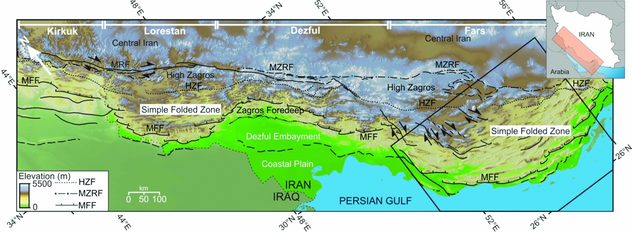
Figure 1. (Colour online) (a) Shaded-relief SRTM topography of the Zagros Mountains (inset shows location within Iran). The Zagros are divided along strike into the Kirkuk, Lorestan, Dezful and Fars domains. Across strike, the mountains are divided into five morphotectonic units (Berberian, Reference Berberian1995). The five units are the High Zagros, the Simple Folded Zone, the Zagros Foredeep, the Zagros coastal plain, and the Persian Gulf–Mesopotamian lowland. The units are separated by basement faults, as inferred by Berberian (Reference Berberian1995), which are the Main Zagros Reverse Fault (MZRF), the High Zagros Fault (HZF) and the Mountain Front Fault (MFF). Most of the present-day deformation occurs within the Simple Folded Zone (e.g. Tatar et al. Reference Tatar, Hatzfeld, Martinod, Walpersdorf, Ghafori-Ashtiani and Chéry2002; Walpersdorf et al. Reference Walpersdorf, Hatzfeld, Nankali, Tavakoli, Nilforoushan, Tatar, Vernant, Chéry and Masson2006). In Lorestan the overall north–south shortening is partitioned onto parallel NW–SE trending folds in the Simple Shear Zone and the right-lateral Main Recent Fault (MRF). This map is adapted from Ramsey, Walker & Jackson (Reference Ramsey, Walker and Jackson2008). It is in a Mercator projection and is rotated 40° from north. The box marks the region represented in Figure 2.

Figure 2. (Colour online) (a) SRTM topography, including the major through-going rivers. Knickpoints identified from longitudinal river profiles are marked by stars. The towns of Jahrum, Lar and Darab encompass a region of internally drained basins (outlined by a dot-dashed line). Major basement faults proposed by Berberian (Reference Berberian1995) are the Main Zagros Reverse Fault (MZRF), the High Zagros Fault (HZF) and the Mountain Front Fault (MFF). (b) The distribution of seismicity and GPS velocities relative to central Iran for the same region as in (a). Earthquake epicentres are from the catalogue of Engdahl, Van der Hilst & Buland (Reference Engdahl, Van der Hilst and Buland1998). Fault-plane solutions of earthquakes are from Talebian & Jackson (Reference Talebian and Jackson2004, and references therein). Light-grey solutions represent those determined from first-motion polarities. Dark grey are from the Harvard CMT (Centroid Moment Tensor) catalogue. Black solutions represent those whose parameters are delimited by P and SH body-waveform modelling. Note the general absence of seismicity in the northeast of the region, typical of central Iran, which extends southwards into the region of internal drainage. GPS velocities are from Walpersdorf et al. (Reference Walpersdorf, Hatzfeld, Nankali, Tavakoli, Nilforoushan, Tatar, Vernant, Chéry and Masson2006) and have been divided into those showing relatively large velocities relative to central Iran (> 3 mm/yr; black triangles, blue in colour version), those that are moving slowly (<3 mm/yr) relative to central Iran (grey triangles, green in online colour version), and those which show, within the uncertainties of the measurements, no motion relative to central Iran (white triangles). This, and all maps in subsequent figures, is in a UTM zone 39 projection.
In the following sections, we describe a large region within the Zagros Mountains of Fars province in SE Iran that is not drained by any through-going river system. Within this region, which was first identified by Mouthereau et al. (Reference Mouthereau, Tensi, Bellahsen, Lacombe, De Boisgrollier and Kargar2007), the landscape is dominated by small internally drained basins separated from one another by anticlinal ridges. We describe how this internally draining region is likely to have formed from the gradual abandonment of a through-going river system in response to fold growth. As the region is now deforming at only very slow rates, our observations imply that the distribution of shortening has changed at some point in the past, providing a potential means of tracking the evolution of deformation within the Zagros over relatively long timescales, and showing a potential intermediate stage in the transition from active folding and thrusting in the Zagros Simple Folded Zone through to the low-relief morphology of the non-deforming and topographically high Central Iranian Plateau.
2. Internally draining basins of the SE Zagros
We describe a part of the SE Zagros, roughly 10000 km2 in area, which is composed of small internally draining basins. The area is confined to a triangle bordered by the towns of Darab, Jahrum and Lar (Figs 2, 3). The region of internal drainage is unique within the Simple Folded Zone of the Zagros as through-going drainage networks exist in the Kirkuk, Lorestan and Dezful regions (Fig. 1). The region that we describe is bounded to the northwest by several prominent right-lateral strike-slip faults including the Kazerun, Karehbas, Sabz-Pushan and Sarvestan faults (Fig. 2). The seismically active Surmeh reverse fault, which intersects at its western end with the Karehbas strike-slip fault, runs along the southern margin of the internally drained region (Fig. 2). A detailed description of the faulting in this part of the Zagros can be found, for example, in Mouthereau et al. (Reference Mouthereau, Tensi, Bellahsen, Lacombe, De Boisgrollier and Kargar2007).

Figure 3. (Colour online) (a) SRTM 90 m DEM of the region of internally drained basins (see Fig. 2a for location). Areas of ponded drainage are outlined by a dotted line. Dry valleys floored by alluvial sediment are marked by black stars. (b) Local slope map for the same area as shown in part (a). White pixels delineate regions of very low slope (0–0.5°). A belt of continuously low slope is marked out by the arrowheads. The very low slope regions are highlighted in orange on the colour version.
The folds that bound this part of the SE Zagros are predominantly Oligo-Miocene Asmari-Jahrum limestone and partially hollowed out ridges of Miocene and Plio-Pleistocene sediments. Their flanks are incised by consequent low-order streams. None of the folds are cut by regional through-going rivers, and no large drainage system incises the flat-lying basins. A few of the anticline crests are, however, cut by minor rivers that incise steep gorges (e.g. Figs 3, 4) and suggest that greater through-flowing rivers existed at some point in the past (see Section 3).

Figure 4. (Colour online) MrSID Landsat TM+ mosaic (the location is marked by a black box in Fig. 3a). Note the areas of ponded drainage and the deep, sediment-floored gorges cutting north to south through the crests of anticlines. The gorges contain only minor streams at the present day.
At present, drainage collects in shallow ponded lakes, and the basins are filled by Quaternary sediments that isolate peaks of the resistant Asmari (Tertiary) and Bangestan (Mesozoic) limestone formations. The fold crests both inside and outside the internally drained region are at similar elevations (1200–1500 m; Fig. 3a). The internally drained basin floors, however, are elevated by ~200 to 400 m with respect to basins along strike that have through-going drainage within them (profile II–II′ in Fig. 5).

Figure 5. Topographic profiles from NE to SW and from NW to SE; locations are marked in Figure 3a. The slope of the valley floors of profile I–I′ step down to the south and are gently tilted southwards (compare to the river profiles in Fig. 6). The slope of profile II–II′ remains flat and roughly constant from east to west across the region of internal drainage.
3. Evidence for an ancestral through-going drainage network
At present, the Mand and Kul rivers are the only two through-going rivers to transverse the folds of the SE Zagros and are separated by the wide internally draining region described in Section 2 (Fig. 2; Mouthereau et al. Reference Mouthereau, Tensi, Bellahsen, Lacombe, De Boisgrollier and Kargar2007). We now consider whether other through-going drainage once existed within the region of internally drained basins, either in the form of a more extensive tributary network to the Mand and Kul rivers, or as a separate through-going river system.
Although the internally drained basins are elongated roughly E–W, along the structural grain, a number of dry valleys floored by alluvium mark out an almost continuous N–S route from the headwaters of the Kul river to the Shur 1 (Fig. 3b). The route is highlighted by a virtually continuous belt of very low local slope (arrowheads in Fig. 3b). Wind gaps are found at locations where the line of low-slope pixels intersects with anticlinal ridges (compare Fig. 3a and b) and presumably mark points where adjacent basins were once linked by an incising river channel.
A NE–SW topographic profile through the internally drained basins (profile I–I′, Fig. 5) shows flat-lying sediment perched at elevations of ~1100 m and ~800 m. Once the profile crosses the basins drained by the longitudinal Almarvdasht and Shur 1 rivers (Fig. 3a), the topography abruptly steps down to the south, and the slope of the valley floors is tilted very gently southwards. This geometry is reminiscent of the stepped channel profiles of the Mand and Kul rivers (Fig. 6, as discussed below).

Figure 6. Longitudinal river profiles along the Mand and Kul rivers (the two major transverse catchments of the SE Zagros, see Fig. 2). Sections marked as longitudinal represent places where the rivers flow parallel to structure. Knickpoints (kp) in the profiles correlate with gorges through limestone fold axes and are numbered in the same order as in Figure 2a. Low gradient areas are likely to represent regions of forced sediment aggradation. (HZ – High Zagros, SFZ – Simple Folded Zone, ZF – Zagros Foredeep, CP – Coastal Plain, see caption to Fig. 1.)
Two large E–W-oriented basins are also dominated by low-slope pixels and contain extensive regions of ponded drainage (see Fig. 2a). A roughly NW–SE profile (profile II–II′, Fig. 5) across the area puts these E–W basins at a constant height of ~800 m that drops to lower elevations as they cross the Mand and Shur 2 river valleys to the east and to the west.
In summary, the presence of an almost continuous line of low-slope pixels that are linked by wind gaps in anticlinal ridges indicates that at some point in the past drainage, similar to the present-day Mand and Kul rivers, once flowed in transverse and parallel river segments through these basins. In Figure 7 we reconstruct the original drainage network of the Fars Zagros based on the observations provided above. Wind gaps preserved on fold crests delimit the location of rivers as they traversed anticlinal ridges. The course of the rivers in the interior of the basins is not certain, as the basins are filled in with sediments, and the original channels have been covered. We have, therefore, inferred the river to have taken the most direct route between successive wind gaps.

Figure 7. (Colour online) Reconstruction of the ancestral through-going drainage of the Zagros. Presently abandoned river systems are marked by thickened, dotted black lines (red lines on the colour version). Locations where the river courses are preserved as wind gaps are marked by black stars. Drainage paths between the wind gaps are somewhat conjectural, as all evidence of the channels has been covered by ponded sediment. The clearest route through the mountains is for the river system to turn to the east, through Lar, to connect with the headwaters of the Shur 2 river. It is possible, however, that it instead followed a southward, more direct route that is no longer preserved as wind gaps.
By comparison with presently active drainage in the Kul and Mand catchments (Fig. 2), we infer that tributaries of the abandoned river network would have flowed transverse to structure along the fold-bounded basins to join a single trunk stream (Fig. 7). The linear alignment of wind gaps in the more inland parts of the palaeo-drainage network suggest that the trunk stream flowed to the southwest in its upper reaches. The alignment of four wind gaps parallel to the fold trend near Lar suggests that the trunk stream then bent abruptly to the east to eventually join with the Shur 2 river. However, wind gaps within the southwestern part of the internally drained region suggest a connection to the westward-flowing Shur 1 river (Fig. 7). It is possible that the main trunk river once flowed either westward into the Shur 1 river, or even directly south into the Persian Gulf, but no evidence for these paths is preserved in the geomorphology. Ramsey, Walker & Jackson (Reference Ramsey, Walker and Jackson2008) proposed a similar drainage evolution for the Mehran river (Fig. 2), which now flows eastwards along a fold-parallel valley to reach the Persian Gulf, but which is likely to have once flowed southwards in a direct course to the Gulf. Lateral fold growth, and linkage of segments to form a continuous fold train ~100 km in length (in a manner described in Section 4.b), is thought to have caused the eastward deflection of the original course of the Mehran river. It is likely that other E–W river courses in the Zagros are caused by diversion around the ends of coalescing fold segments (Ramsey, Walker & Jackson, Reference Ramsey, Walker and Jackson2008).
4. Structural influence on the abandonment of drainage
4.a. Present-day and late Quaternary deformation in the Fars Zagros
Having established that a large through-going river system once existed in a now internally drained part of the Zagros, we now investigate possible causes of the abandonment. The internally draining region is substantially higher than along-strike parts of the Zagros and parts of the range located across strike to the south (see Figs 3, 5). Most of the seismicity associated with thrust faulting in the Zagros, apart from some earthquakes of small magnitude that are not included in the catalogue of Engdahl, Van der Hilst & Buland (Reference Engdahl, Van der Hilst and Buland1998), is limited to areas with elevations < 1000 m (e.g. Talebian & Jackson, Reference Talebian and Jackson2004; Allen, Jackson & Walker, Reference Allen, Jackson and Walker2004; Hatzfeld et al. Reference Hatzfeld, Authemayou, van der Beek, Bellier, Lave, Oviesi, Tatar, Tavakoli, Walpersdorf, Yamini-Fard, Leturmy and Robin2010; Allen, Blanc & Saville, Reference Allen, Blanc and Saville2010). An exception to this general pattern is a series of thrust-faulting events at ~28°15′ N, 54°E in July 2003, with the two largest earthquakes having moment magnitudes of 5.5 and 5.7 (see Fig. 2b) at an elevation of ~1100 m. Other earthquakes do occur within high (> 1000 m elevation) ground in other parts of the Zagros, but these are generally strike-slip events within the range (e.g. fig. 15 of Talebian & Jackson, Reference Talebian and Jackson2004). The aseismic nature of our study area conforms to this general pattern, and there are no obvious strike-slip faults within it.
GPS studies by Walpersdorf et al. (Reference Walpersdorf, Hatzfeld, Nankali, Tavakoli, Nilforoushan, Tatar, Vernant, Chéry and Masson2006) showed, within the resolution of their measurements, that at least 75% of the shortening in the Fars Zagros occurs at low elevations close to the Persian Gulf shore (Fig. 2b). In particular, an along-strike variation is noted in the velocities of GPS stations FAR2 and LAR2 (which are located outside the region of elevated topography and have GPS velocities of > 3 mm/yr relative to central Iran) and stations QIR2, ISL2 and BIG2 (which are located inside the region of elevated topography and show very little motion relative to central Iran). Neither the seismicity (representing deformation throughout the thickness of the brittle crust), nor the GPS measurements (representing strain at the Earth's surface) show appreciable amounts of deformation. Together, the GPS and seismicity suggest (1) that deformation in the lower and upper parts of the brittle crust are not decoupled, and (2) that the internally draining region of Fars province is not rapidly deforming, either seismically or aseismically, at the present day.
A similar pattern of strain distribution, with deformation concentrated in regions of lower elevation closer to the coast, was determined by Oveisi et al. (Reference Oveisi, Lave, van der Beek, Carcaillet, Benedetti and Aubourg2009) and Oveisi, Lave & van der Beek (Reference Oveisi, Lave, van der Beek, Lacombe, Lave, Roure and Verges2007) who measured the deformation of fluvial and marine terraces from the last ~100 ka to determine rates of shortening across individual folds in transects perpendicular to the strike of the Fars Zagros and found a concentration of deformation across folds closer to the Persian Gulf. It therefore appears that the concentration of shortening at lower elevations is a characteristic of the Zagros deformation over the last 100 ka, and is not an anomaly resulting from the short timescales over which GPS and seismicity have been recorded (e.g. Hatzfeld et al. Reference Hatzfeld, Authemayou, van der Beek, Bellier, Lave, Oviesi, Tatar, Tavakoli, Walpersdorf, Yamini-Fard, Leturmy and Robin2010; Hatzfeld & Molnar, Reference Hatzfeld and Molnar2010).
4.b. Fold growth and drainage abandonment
Disruption to the drainage network within the Zagros Mountains has been used by a number of authors to try to gain insights into the tectonic history (e.g. Oberlander, Reference Oberlander, Morisawa and Hack1985; Simpson, Reference Simpson2004; Mouthereau et al. Reference Mouthereau, Tensi, Bellahsen, Lacombe, De Boisgrollier and Kargar2007; Burberry, Cosgrove & Liu, Reference Burberry, Cosgrove, Liu, Leturmy and Robin2010). For instance, Mouthereau et al. (Reference Mouthereau, Tensi, Bellahsen, Lacombe, De Boisgrollier and Kargar2007) noted that the absence of linear river networks transverse to structure suggests a strong structural control on the development of the drainage networks. Ramsey, Walker & Jackson (Reference Ramsey, Walker and Jackson2008) used the topography of the Zagros folds, and remnant drainage patterns preserved within them, to interpret the > 100 km long fold trains as resulting from the merger of several relatively short segments, each ~20–40 km long, that have propagated laterally towards one another (see Fig. 8). Figure 8 highlights the interplay between lateral fold growth and the development of the present-day drainage of the Zagros: rivers are deflected along individual fold segments, become trapped at segment boundaries, form deep gorges by down-cutting, and eventually are defeated with the original courses preserved as dry valleys and wind gaps within central parts of the fold chains.

Figure 8. A cartoon, after Ramsey, Walker & Jackson (Reference Ramsey, Walker and Jackson2008), showing a mechanism of fold growth and linkage that is compatible with observations of the geomorphology of the Zagros. A to D represent the lateral propagation (or the gradual emergence of resistant lithology) of two fold segments through time. Rivers are diverted around the tips of the growing folds. As the folds continue to propagate towards one another the tips begin to form a continuous structure. The rivers have increased their stream power by joining together and incise a gorge through the now continuous anticline. The narrowed outlet prevents the efficient removal of sediment from the basin. A potential consequence of this model is that the rivers might eventually be defeated by continued fold growth, thus leading to the development of internally drained regions. See Ramsey, Walker & Jackson (Reference Ramsey, Walker and Jackson2008) for further details.
Presumably, the extensive deposition of sediment within the internally drained part of Fars was associated with an imbalance between stream power, sediment supply and uplift rate. For example, the river system may have been choked by large amounts of soft sediment removed from the outer flanks of the Asmari folds, and the entire region may have become isolated simultaneously. However, it is clear that the abandonment of drainage, which was once through-going, must have resulted in some way from the uplift, growth and exhumation of anticlinal folds.
Stream profiles along the Mand and Kul rivers (Fig. 6) show the probable mechanisms of drainage abandonment. The headwaters of both rivers show a series of low gradient sections punctuated by steep knickpoints. The knickpoints correspond to places where the rivers cut gorges through resistant rocks exposed in the fold axes (the locations of knickpoints are marked as stars on Fig. 2a). The river is forced to deposit sediment upstream of each gorge. Continued uplift and coalescence of fold segments may eventually result in the defeat of the river system (Ramsey, Walker & Jackson, Reference Ramsey, Walker and Jackson2008). This process appears to have occurred within the internally draining part of the Zagros, and may well occur in the catchments of the Mand and Kul rivers in the future. Defeat of the Mand and Kul rivers will increase the area of internally drained basins within the Zagros.
The relatively simple scenario for the development of internal drainage, described above, requires continued fold growth to defeat the through-going drainage systems. Once the internally drained basins have formed, the deposition of sediments within them decreases the relief between these basins and adjacent peaks, and thus reduces the stresses in the elastic upper crust required to maintain the topography (e.g. Jackson & White, Reference Jackson and White1989). Those stresses concentrate at the edge of high relief, and hence regions of present-day sediment accumulation may be expected to correlate with a reduced level of active deformation and a migration of shortening to regions with steeper topographic gradients. The regions of sediment accumulation in the Fars Zagros show little GPS-derived crustal deformation and reduced levels of seismicity relative to surrounding parts of the range. Thus, although active folding is likely to be important in the generation of internally draining regions by acting as barriers to through-going river systems, the ponding of sediment within these regions may subsequently act to reduce rates of active deformation.
5. Ponding of sediment, increased elevation and the distribution of active shortening in the Zagros
A correlation between the higher elevations and the apparent cessation of active faulting within this part of the Zagros was first noted by Jackson & McKenzie (Reference Jackson and McKenzie1984). The observation that deformation in the Fars Zagros concentrates in particular places appears to be at odds with descriptions of the Zagros as a tapering orogenic wedge (e.g. Ford, Reference Ford2004; Mouthereau, Lacombe & Meyer, Reference Mouthereau, Lacombe and Meyer2006), as all of the critically-tapering wedge should be at the point of failure, and hence deformation should occur throughout the wedge irrespective of elevation (but note that the major active faults within a critical wedge 25 km thick and with an angle of internal friction of 30° could be separated by up to ~85 km; Mouthereau, Lacombe & Meyer, Reference Mouthereau, Lacombe and Meyer2006). A progressive basinward migration of activity, with the initiation of new thrusts in the footwall of the older reverse faults, is another possible reason for the present inactivity of folding in inland, higher parts of the range (e.g. Sattarzadeh, Cosgrove & Vita-Finzi, Reference Sattarzadeh, Cosgrove, Vita-Finzi, Clift, Kroon, Gaedicke and Craig2002; Sepehr & Cosgrove, Reference Sepehr and Cosgrove2004). The geomorphology of the Fars region appears, however, to be inconsistent with a progressive basinward migration of activity as the formation of the large internally drained region requires that folding was active in the geologically recent past.
Mouthereau et al. (Reference Mouthereau, Tensi, Bellahsen, Lacombe, De Boisgrollier and Kargar2007) suggested that the abandonment of through-going drainage within the Fars Zagros results from the lowering of surface gradients in the hanging wall of the active Surmeh fault to the south (e.g. Fig. 2). This suggestion is feasible, though it does not account for the apparent cessation of folding within the hanging wall of the Surmeh fault implied by the geomorphology of this region. Talebian & Jackson (Reference Talebian and Jackson2004) and Allen, Jackson & Walker (Reference Allen, Jackson and Walker2004) instead speculated that the increased elevation in the Fars Zagros, and the corresponding increase in isostatically compensated crustal thickness, have caused the migration of deformation to lower elevations by the generation of lateral variations in vertically averaged stress (termed buoyancy forces, e.g. Dalmayrac & Molnar, Reference Dalmayrac and Molnar1981; England & Jackson, Reference England and Jackson1989). Buoyancy forces associated with compensated topography are proportional to the gradient of crustal thickness squared (England & McKenzie, Reference England and McKenzie1982). Deformation is thus concentrated at abrupt changes in compensated crustal thickness (e.g. England & Jackson, Reference England and Jackson1989). The edges of the elevated, internally drained part of the Fars Zagros are abrupt and we might, therefore, expect deformation to be concentrated at these edges. The extent to which the elevated topography within the internally drained region is isostatically compensated is not, however, known. Crustal thickness estimates obtained by Paul et al. (Reference Paul, Kaviani, Hatzfeld, Vergne and Mokhtari2006) from receiver functions in a NE–SW profile perpendicular to the strike of the Zagros at Shiraz (e.g. Fig. 2), showed a relatively constant crustal thickness across both the Simple Folded Zone and the High Zagros of ~45 km. Any increase in crustal thickness beneath the topographically high parts of the Fars Zagros should, therefore, be less than the resolution of these crustal depth estimates. The ~80 km maximum lateral extent of the elevated region (Fig. 3) may, in any case, be too small a wavelength to allow full compensation (Watts, Reference Watts2001).
Allen, Blanc & Saville (Reference Allen, Blanc and Saville2010) proposed a continual southward expansion of the Central Iranian Plateau, with shortening within the inland parts of the Zagros range ceasing once a threshold surface elevation is reached. In the model of Allen, Blanc & Saville (Reference Allen, Blanc and Saville2010), the incorporation of parts of the Simple Folded Zone that have reached elevations of > 1 km into the non-deforming Central Iranian Plateau results in a lowering of surface gradients, which will reduce the power of southward flowing rivers, and will promote the abandonment of through-going drainage. The incorporation of inner parts of the Zagros into the Central Iranian Plateau might, therefore, play an additional role in controlling the surface processes and producing the morphology of internally drained basins that typifies the plateau regions.
6. Conclusions
We have shown that folding, drainage abandonment and sediment accumulation all play roles in shaping the topography of the Zagros Mountains. Our observations suggest that higher elevations in parts of the Fars Zagros are due to the ponding of sediment within internally drained basins. The sediment ponding results from the abandonment of a through-going drainage system: the original course of which is preserved as an aligned series of wind gaps in the crests of anticlinal folds. The abandonment of through-going drainage and the development of internally drained regions within the Zagros hence appear to be a direct result of deformation. However, we note that the region of internal drainage now correlates with an apparent reduction in present-day tectonic activity. The correlation between drainage abandonment and slow rates of deformation, which is the opposite to what would be expected from our analysis of the geomorphology, leads us to speculate that changes in the drainage history may have influenced the present-day distribution of deformation. We speculate that the slowing of rates of shortening in this part of the Zagros may be related to buoyancy forces associated with the elevated topography, though the exact nature of the link remains unclear.
The morphology of the Central Iranian Plateau, which is apparently not deforming apart from on rare strike-slip faults, is dominated by wide low relief desert regions in which the drainage pools within internally drained basins. Further south, these wide plains merge gradually with the High Zagros, in which segmented, isolated mountain ranges of Mesozoic rocks are drowned within continuous basins of sediment. The High Zagros is poorly drained and has extensive marshlands and elongated lakes that eventually flow into Central Iran. Therefore, the internally draining basins identified in this paper could be an early phase in a gradual process of drainage abandonment, with earlier phases recorded in the drowned folds of the High Zagros region. As deformation continues to step southwestwards, and localized uplift on faults wanes in the presently active parts of the Simple Folded Zone, we speculate that the present-day internally draining parts of the Zagros may evolve to a similar topography to that of the High Zagros, and eventually Central Iran.
Acknowledgements
RTW is supported by a University Research Fellowship from the Royal Society of London. This research is supported by NERC in the form of the Centre for the Observation and Modelling of Earthquakes and Tectonics (COMET). Figure 2 was made using the GMT software of Wessel & Smith (Reference Wessel and Smith1998). We thank Yopan Takada and Mike Leeder for discussions, Mark Allen and Peter van der Beek for comments on an early manuscript, and Denis Hatzfeld, John Cosgrove and Olivier Lacombe for detailed and helpful reviews.


