


Introduction
The dispersal of crops and farming techniques across prehistoric Eurasia led to profound social transformations and ecological impacts across the continent (Jones et al. Reference Jones2011; Liu et al. Reference Liu2019). Between the sixth and the second millennia BC, the cultivation of wheat and barley expanded from its centre of origin in South-west Asia into East Asia, while the cultivation of broomcorn millet (Panicum miliaceum) and foxtail millet (Setaria italica) dispersed in the opposite direction: from northern China into Central and South-west Asia and Europe (e.g. Zhao Reference Zhao2011; Lightfoot et al. Reference Lightfoot, Liu and Jones2013; Liu et al. Reference Liu2017). Research on such episodes of prehistoric ‘food globalisation’ initially focused on the dispersal of particular crops, but more recently has shifted attention to the associated spread and development of knowledge about crop management and cultivation strategies, and the social and economic contexts into which these crops were integrated (e.g. Liu & Reid Reference Liu and Reid2020; Vaiglova et al. Reference Vaiglova2021). One of the major distinctions between these two broad agricultural systems is their variable seasonal demand for water. Broomcorn and foxtail millets are generally sown in the spring and harvested in the autumn, requiring a steady supply of water during the summer growing season, but otherwise tolerate water stress and poor soil conditions. In contrast, wheat and barley are predominantly autumn-sown and grow through the winter; they are tolerant of frost but require much higher amounts of water and soil nutrients compared with millets.
Exactly how the early farmers of wheat and barley in ancient China managed these new crops remains unclear: either by adopting the strategies originally developed in South-west Asia for the cultivation of these crops or by relying on the established and more familiar strategies used for local millet cultivation. To address this gap in our understanding, we investigate whether the eastward dispersal of wheat and barley into ancient China was accompanied by the associated cultivation strategies that originated in South-west Asia. To do so, we employ macrofossil and stable isotope analyses, which permit direct assessment of the growing conditions of these crops—in particular, watering regimes and soil status. We focus on Zhuanglang, a county in Gansu Province, on the western Loess Plateau in China, which lies at the crossroads between the eastern and western movements of prehistoric crops. We analyse recently collected archaeobotanical assemblages from 50 sites spanning in date from 6000 BC to the nineteenth century AD.
Stable isotope analysis of plant remains
The growing conditions of crops can be investigated through the measurement of the stable carbon (δ13C) and nitrogen (δ15N) isotope values of (charred) plant remains. In particular, δ13C values can be used to infer crop water status (i.e. water use efficiency during plant growth), where lower δ13C values signal the greater availability of water during the grain filling period—that is, the crucial stage in seed formation (e.g. Farquhar & Sharkey Reference Farquhar and Sharkey1982; Araus et al. Reference Araus1999; Flohr et al. Reference Flohr, Müldner and Jenkins2011; Wallace et al. Reference Wallace2013). Meanwhile, measurement of δ15N values allows the assessment of the 15N enrichment of soils, which can be caused by either natural (e.g. salinity or denitrification) or anthropogenic (e.g. the application of animal manure or organic waste) factors (Bogaard et al. Reference Bogaard, Heaton, Poulton and Merbach2007; Fraser et al. Reference Fraser2011).
The interpretation of δ13C and δ15N values from charred crops relies on principles established through measurements taken from controlled experiments and traditional non-mechanised farming settings in Europe and the Eastern Mediterranean, North Africa and South Asia (Bogaard et al. Reference Bogaard, Heaton, Poulton and Merbach2007; Fraser et al. Reference Fraser2011; Styring et al. Reference Styring2016; Jones et al. Reference Jones2021). These studies provide comparative estimates of the degree of 13C and 15N enrichment produced by varying water and soil fertility regimes. Isotopic analyses of δ13C and δ15N values from archaeobotanical materials have illuminated early crop management in Europe and the Middle East, providing insight into the antiquity of manuring practices and systematic water management as early as the sixth millennium BC (e.g. Bogaard et al. Reference Bogaard2013; Wallace et al. Reference Wallace2015). Here, we use a similar approach to address the growing conditions and cultivation strategies employed by early farmers of wheat and barley in China.
Zhuanglang County
Zhuanglang County is located in the western Loess Plateau. Situated in the western foothills of the Liupan Mountains, it covers an area of approximately 1500km2 (Figure 1). It is characterised by a continental monsoon climate, with mean annual temperatures of 7.9°C and mean annual precipitation of approximately 550mm, peaking between July and September. Across Zhuanglang County, elevation declines gradually from north-east to south-west, from 2857m asl at Peach Hill to 1405m at Zhangjiawan. Two main rivers, the Hulu and Shuiluo, flow through the region.

Figure 1. Locations of sites under investigation at Zhuanglang: 1) Nanhugucheng; 2) Wowoping; 3) Dujiagoumen; 4) Tijiaping; 5) Buziping; 6) Yujiawan; 7) Shangping; 8) Dongshanzui; 9) Taijiazui; 10) Caojiayuan; 11) Yuliaobuzi; 12) Gaozhuang; 13) Shaojiaping; 14) Xiaodunshan; 15) Jiajiaping; 16) Jiuyuan; 17) Shidongmen; 18) Sumiaoyuantou; 19) Dazuiliang; 20) Duanshanping; 21) Wanerwa; 22) Daping; 23) Taijiguan; 24) Xuanmaoding; 25) Wanjiayuan; 26) Yaping; 27) Yejiabuzi; 28) Hexianzui; 29) Dadichuan; 30) Guanqianmen; 31) Yujiayuan; 32) Chuankouliujia; 33) Guajiazhuang; 34) Liubuping; 35) Caiziwa; 36) Guajiazhuang; 37) Siping; 38) Yumushuwan; 39) Lishuwa; 40) Shuiluocheng; 41) Xulinian; 42) Wujiachuan; 43) Jiajiahewan; 44) Zhangjiayuan; 45) Ximianyuan; 46) Xujiacheng; 47) Shimenkou; 48) Yaerzui; 49) Guandi; and 50) Xihe (map by the authors).
Palaeoenvironmental reconstruction suggests that the western Loess Plateau became increasingly arid over the course of the Mid to Late Holocene due to the weakening of the East Asian Summer Monsoon and the effects of the 4.2ka BP aridification event (Dykoski et al. Reference Dykoski2005; Wang et al. Reference Wang2005). At a local level, the analysis of sediment cores from the nearby Tianchi Lake—a unique, high-altitude freshwater lake situated in the Liupan Mountains—shows a highly complex climate history, with a relatively wet environment between 6200 and 2900 cal BP, followed by increased aridification, peaking c. 1100 cal BP (Zhou et al. Reference Zhou2010).
The local prehistoric cultural phases include: the Dadiwan phase I (6000–5300 BC); the Early (4300–4000 BC) and Middle–Late Yangshao (4000–2300 BC); the Qijia (2300–1500 BC); and the Siwa (1500–300 BC) periods (Bureau of National Cultural Relics 2011; Wang Reference Wang2012). The historical era can be divided into several sequential periods, including the Han–Tang (202 BC–AD 907), the Song–Yuan (AD 960–1368) and the Ming–Qing (AD 1368–1911) Dynasties (Dong et al. Reference Dong2012). For this study, we employ a six-phase sequence (from Middle–Late Yangshao to Ming–Qing) as a general chronological framework, which is defined by 39 radiocarbon measurements (see below). Figure 2 provides details of the prehistoric and historic chronological sequences.

Figure 2. Thirty-nine radiocarbon determinations from the four types of cereal (wheat (Triticum cf. aestivum), barley (Hordeum vulgare), broomcorn millet (Panicum miliaceum) and foxtail millet (Setaria italica)) found at the study sites. These fall into six prehistoric and historic phases, which span eight millennia. Dates were calibrated in OxCal v4.4.2, using the IntCal20 atmospheric curve (Bronk Ramsey Reference Bronk Ramsey2020; Reimer et al. Reference Reimer2020) (figure by the authors).
Materials and methods
In 2013, 50 archaeological sites were excavated in Zhuanglang (for locations, see Figure 1; for site information, see Table S1 in the online supplementary materials (OSM)). A total of 124 soil samples from these sites were collected for flotation; these were processed in the field using a ‘Flote-Tech’ machine, as described by Rossen (Reference Rossen1999) (see OSM1 & 2). The collected light fractions were subsequently analysed at the Institute of Archaeology, Chinese Academy of Social Sciences. Thirty-five charred cereal remains (including wheat, barley, broomcorn millet and foxtail millet) were selected for AMS radiocarbon measurements at the Ministry of Education Key Laboratory of Western China's Environmental Systems, Lanzhou University (n = 12) and the Radiocarbon Accelerator Laboratory, Peking University (n = 23). An additional four samples were radiocarbon dated by Beta Analytic (OSM3 and Table S2). Sample pre-treatment for isotopic measurement was carried out at the McDonald Institute for Archaeological Research, Cambridge, using the gentle acid protocol described by Vaiglova and colleagues (Reference Vaiglova2014). Stable isotope measurements were carried out at the Godwin Laboratory, Cambridge, using an automated Costech elemental analyser coupled with a continuous flow mode to a Thermo Finnigan MAT253 mass spectrometer (for complete details, see OSM4).
Archaeobotanical assemblages
Over 35 000 charred seed remains were identified from the 124 flotation samples. The most abundant grains are cereals, including: foxtail millet; broomcorn millet; free-threshing wheat (Triticum cf. aestivum); barley (Hordeum vulgare) (Figure 3); oat (Avena sativa); buckwheat (Fagopyrum esculentum); and sorghum (Sorghum bicolor). Identified pulses include pea (Pisum sativum), lentil (Lens culinaris), mung bean (Vigna radiata) and cowpea (Vigna unguiculata). Other economically important plants present include flax (Linum usitatissimum), sesame (Sesamum indicum), hemp (Cannabis sativa), rapeseed (Brassica napus) and Sichuan pepper (Zanthoxylum bungeanum); 53 species of weedy/herbal plants were also identified (for a complete list, see Figure S1 and Table S1).

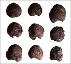
Figure 3. Charred plant remains recovered from sites in Zhuanglang County: a–c) foxtail millet (Setaria italica) from Xuanmaoding-H1 (a), Shaojiaping-H1 (b) and Dongshanzui-H2 (c); d–f) broomcorn millet (Panicum miliaceum) from Shangping-H2-1 (d), Dadichuan-H1 (e) and Caojiayuan-H2 (f); g–i) wheat (Triticum cf. aestivum) from Hexianzui-H1 (g), Liubuping-H1 (h) and Dongshanzui-H2 (i); j–l) barley (Hordeum vulgare) from Gaozhuang-H1 (j), Yujiayuan-H1 (k) and Shangping-H2-1 (l); scales in mm (images taken by Haiming Li).
Variation in the taxonomic composition of the flotation samples between periods reflects long-term shifts in cropping systems across eight millennia (Figure 4). While the complete assessment of the archaeobotanical assemblage is ongoing, it is clear that two indigenous millet crops dominate the assemblages dated to the Yangshao (4300–2300 BC) and the Qijia (2300–1500 BC) periods. South-west Asian crops (wheat and barley) first appeared during the Qijia period, becoming more abundant by the Siwa (1500–300 BC) period, at which point barley became more common than wheat. The crop assemblages of the historical periods are increasingly diverse, beginning with the Han–Tang Dynasties (220 BC–AD 907). By the time of the Song–Yuan (AD 960–1368) and the Ming–Qing (AD 1368–1911) Dynasties, wheat and barley had become the dominant cereals.

Figure 4. Diachronic changes in the taxonomic combination of major cereals throughout the prehistoric and historical phases (figure by the authors).
Stable isotope results
The present study applies the interpretative framework established by Wallace et al. (Reference Wallace2013), which uses the Δ13C values of plants (converted from δ13C values to account for fluctuations in atmospheric δ13CCO2, as detailed in OSM4) to assess crop water status. This framework accounts for the physiologically mediated differences in carbon isotope assimilation between wheat and barley, such that barley tends to have Δ13C values that are 1–2‰ higher than wheat when grown under the same watering conditions (Voltas et al. Reference Voltas1999; Wallace et al. Reference Wallace2013). Here, Wallace et al.'s (2013) original division between ‘poorly watered’ and ‘moderately watered’ plants is referred to as the ‘optimal watering threshold’ (16.0‰ for wheat and 17.0‰ for barley), while the division between ‘moderately watered’ and ‘well-watered plants’ is referred to as the ‘superfluous watering threshold’ (17.0‰ for wheat and 18.5‰ for barley). These thresholds are taken to indicate whether or not crop water status limited plant growth (e.g. Vaiglova et al. Reference Vaiglova2021). For millet crops, a positive relationship between δ13C and water availability has been previously documented (e.g. An et al. Reference An2015a; Reid et al. Reference Reid, Lalk, Marshall and Liu2018). Despite this, the relatively small differences between millets grown under varying watering conditions (<2.0‰), as well as large intra-plant variation in stable carbon isotope values, mean that millet δ13C values are more challenging to interpret in relation to past water management strategies (Lightfoot et al. Reference Lightfoot2016, Reference Lightfoot2020; Sanborn et al. Reference Sanborn, Reid, Bradley and Liu2021).
Stable isotope results from the analysed plant samples are summarised in Table 1 (for full details, see Table S1). Over half of the wheat samples (n = 26) yielded Δ13C values above the optimal watering threshold, with six samples above the superfluous watering threshold (Figure 5a), suggesting that water availability did not pose a limitation to the successful cultivation of wheat. In contrast, all of the barley samples but one (n = 21) have values below the superfluous watering threshold, with just under two-thirds (n = 13) yielding Δ13C below the optimal watering threshold. This suggests that barley was cultivated under conditions where water was limited. The results do not show significant changes in the Δ13C values of either wheat or barley over time (analysis of variance, wheat: F(4, 21) = 1.924, p = 0.144; barley: F(4, 16) = 0.686, p = 0.612). There is no clear patterning of chronological shifts. Similarly, no statistically meaningful differences can be identified among the samples of foxtail millet and broomcorn millet in different periods through time (foxtail millet: F (5, 72) = 1.122, p = 0.356; broomcorn millet: F(5, 72) = 0.442, p = 0.818).

Figure 5. The Δ13C (a–d) and δ15N (e–h) values of archaeological wheat, barley, foxtail and broomcorn millet grains from Zhuanglang County. Dashed lines represent the optimal watering threshold and superfluous watering threshold for wheat and barley (a & b), and low, medium and high manuring thresholds, as well as local vegetation baseline (e–h) (figure by the authors).
Table 1. A summary of Δ13C (wheat and barley), δ13C (foxtail and broomcorn millet) and δ15N values (all species) measured from distinct periods at the study sites.

To assess the potential application of manure during crop cultivation, we employ the framework established by Styring et al. (Reference Styring2016), which takes into account variation in precipitation levels in the interpretation of δ15N values as indicators of manuring. Given that the current mean annual precipitation in Zhuanglang is approximately 550mm, the estimated threshold of plant δ15N values for low, medium and high manuring levels is approximately 2.5‰, 3.5‰ and 8.5‰, respectively. The local vegetation baseline is estimated to be approximately 1.9‰, based on average δ15N values of herbivores from prehistoric contexts on the western Loess Plateau, using a diet-to-tissue offset of 4.5‰ (Barton Reference Barton2009; Ma et al. Reference Ma2014, Reference Ma2016).
All of the crop samples (apart from one outlier) have δ15N values that are above the estimated medium manuring level and are significantly higher than the local vegetation baseline. An analysis of variance shows no statistically meaningful differences in the δ15N values of crop species between the periods (wheat: F(5, 24), α = 0.05, p = 0.786; barley: F(5, 24), α = 0.05, p = 0.517; foxtail millet: F(6, 72), α = 0.05, p = 0.25; broomcorn millet: F(6, 74), α = 0.05, p = 0.068). The lack of statistically meaningful differences in the δ15N values of wheat and barley suggests that both crops continued to be cultivated in similar soil conditions throughout the long timespan under investigation.
Discussion
The results from Zhuanglang County suggest that farmers over the past eight millennia employed water management strategies to facilitate the cultivation of crops. The majority of the wheat samples from all periods have values above the optimal watering threshold (Figure 5), indicating that growth was not limited by water availability. Given the arid local environment and the water requirements for the cultivation of wheat, this could not have been achieved without some form of intentional water management. This does not necessarily imply channel irrigation or deliberate hand watering, however, and evidence for such techniques is currently lacking in the archaeological record. Instead, wheat crops may have been strategically sown in areas with the best water availability—either close to local springs or in soils with high water retention. In the latter scenario, this would imply a spring–autumn growth cycle (the seasons with higher soil water retention) for wheat crops and lends support to our previous hypothesis of the biodiversity of flowering time responses adapting to eastern environments (Liu et al. Reference Liu2017). These results indicate that, as far back as the Qijia and Siwa Cultures of the second millennium BC, strategic cultivation or deliberate irrigation was already used by the first wheat farmers in the study region.
In contrast, barley Δ13C values demonstrate pronounced water stress, with most barley samples falling below the optimal watering threshold, indicating that plant growth was constrained by water availability. This suggests that wheat and barley were probably cultivated under different water regimes or planted at different locations. Figure 6 shows the locations of sites where wheat grains outnumber barley in the archaeobotanical assemblages and vice versa. This demonstrates that most of the sites are located close to local springs and rivers. The sites where barley predominates, however, are more frequently situated at higher altitudes in the hilly areas close to the Liupan Mountains, while sites where wheat predominates are located at lower altitudes, such as the Hulu and Shuiluo river valleys (for examples of typical landscapes of river and hill sites, see Figure 7a–b). Ecologically, barley is more tolerant of drier growing conditions than wheat, and we interpret the cultivation of these two crops in different environmental zones as a strategy to maximise overall yields and optimise land use in a region where water availability was a major limitation.

Figure 6. Site locations where wheat (Triticum cf. aestivum) grains outnumber barley (Hordeum vulgare) (○) and barley grains outnumber wheat (Δ): 1) Gaozhunang; 2) Shangping; 3) Dadichuan; 4) Hexianzui; 5) Nanhugucheng; 6) Shuiluocheng; 7) Xujiacheng; 8) Guajiazhuang; 9) Caiziwa; 10) Yujiayuan; (11) Jiajiahewan; 12) Sumiaoyuantou; 13) Dongshanzui; 14) Chuankouliujia; 15) Zhangjiayuan; 16) Shimenkou; 17) Jiuyuan; 18) Liubuping; 19) Yuliaobuzi; 20) Guandi; 21) Wujiachuan; 22) Guanqianmen; 23) Taijiguan; and 24) Yejiabuzi (figure by the authors).

Figure 7. Examples of: a) the typical landscapes of ‘river sites’ where wheat (Triticum cf. aestivum) outnumbers barley (Hordeum vulgare) (view near Dongshanzui, no. 13 in Figure 6); and b) ‘hill sites’ where barley outnumbers wheat (view near Shangping, no. 2 in Figure 6); c & d) Δ13C values of archaeological wheat and barley from these two types of sites (photographs courtesy Haiming Li and Guanghui Dong).
The distinct strategies for the cultivation of wheat and barley are reflected in the carbon isotope values of these two cereals, which indicate that barley was under water stress regardless of location (Figure 7d). As far as wheat is concerned, however, grains from hill sites are shown to have higher Δ13C values compared with those from lower locations (Figure 7c). This suggests that wheat crops at hill sites benefited from strategic water management in order to provide a buffer against otherwise naturally dry conditions. The use of distinct cultivation strategies for different crops is also attested in the archaeological record of northern Mesopotamia, where barley was cultivated in drier locations, while wheat and pulses were sown near wadis (Styring et al. Reference Styring2017).
In Zhuanglang County, the archaeobotanical record indicates that millets were present, often in large quantities, at almost every site, regardless of topography, signifying that they were an important component of local subsistence systems during all periods. As noted above, the use of δ13C values to infer water status is more challenging for C4 plants. It has been postulated, however, that early Neolithic farmers in the Loess Plateau initially cultivated broomcorn millet and foxtail millet on the foothills of the mountains in order to take advantage of seasonal fluctuations in soil moisture during the summer monsoons (Liu et al. Reference Liu, Hunt and Jones2009). Archaeologically attested sites in the hills surrounding the Liupan Mountains are classic examples of this type of farming system (Figure 7b exemplifies a typical ‘millet’ landscape, where barley became more archaeologically visible than wheat from c. 4000 BP). Thus, if barley was cultivated under similar conditions to millets, which had been grown in the region for thousands of years prior to the introduction of barley, then our research suggests that barley was incorporated directly into locally developed farming systems. Wheat, on the other hand, was introduced to this region alongside the knowledge required for its optimal cultivation (i.e. concerning the management of soils and water availability), which allowed farmers to explore landscapes that were previously deemed untenable during the Neolithic when growing solely millet.
Arable weeds are often used to infer crop growing conditions and can complement the evidence from stable carbon isotope indicators of water status (e.g. Bogaard et al. Reference Bogaard2016). In the assemblages studied here, however, water-demanding taxa are virtually absent (Table S1). Carex (sometimes used as an indicator of field irrigation due to its adaptation to open and well-watered soils (Rühl et al. Reference Rühl, Herbig and Stobbe2015), Malva, Polygonum and Cyperaceae all appear in very low numbers, while Stellaria is absent. This disparity between the isotopic and archaeobotanical evidence may indicate intensive weeding activities or the removal of weeds during crop processing, which would support the idea of the labour-intensive nature of wheat cultivation, with irrigation, weeding and processing all requiring high labour inputs. A more detailed analysis of the weed ecology and crop-processing activities represented at the study sites will help further illuminate this issue.
The wide range of δ15N values for the crops grown in Zhuanglang County indicates that all four cereals (wheat, barley, broomcorn millet and foxtail millet) were cultivated in variable soil conditions throughout the six periods under study. This variability might be the result of several natural and/or anthropogenic causes of soil 15N enrichment, including aridity, soil denitrification and manuring. Aridity would be expected to influence the values of both cultivated crops and herbivore forage. In the current dataset, however, the δ15N values of all four cereals are higher than the local vegetation baseline, suggesting that aridity is unlikely to be the main cause of 15N enrichment. Denitrification may cause 15N enrichment of soils that are affected by seasonal high-volume floods (Finlay & Kendall Reference Finlay, Kendall, Michener and Lajtha2008). This could explain the high δ15N values of wheat, which may have been cultivated on seasonally flooded riverbeds. Barley, which retains equally high δ15N values, however, was probably cultivated on dry soils at higher elevations. Thus, seasonal flooding is unlikely to explain the elevated δ15N values of both crops.
Soil can be enriched with 15N as a result of the application of animal manure or organic waste (such as middening), and this practice has been suggested for wheat and barley cultivation in both South-west Asia and Europe since at least the sixth millennium BC (e.g. Bogaard et al. Reference Bogaard2013; Styring et al. Reference Styring2017; Vaiglova et al. Reference Vaiglova2020). Data from the present study suggest that similar practices, employing manuring/middening of wheat and barley fields, formed an integral part of agricultural strategies from the introduction of these crops to prehistoric China.
In the case of millet, controlled experiments have shown no direct correlation between millets (Setaria and Pennisetum) δ15N values and water availability (Lightfoot et al. Reference Lightfoot2020; Sanborn et al. Reference Sanborn, Reid, Bradley and Liu2021). Experiments using foxtail millet, for example, show significant variability (up to 6‰) in δ15N values between the grains of plants grown under varying water regimes (Lightfoot et al. Reference Lightfoot2020), while studies of pearl millet (Pennisetum glaucum) showed comparatively lower variability (approximately 2‰; Sanborn et al. Reference Sanborn, Reid, Bradley and Liu2021). This lack of correlation between the δ15N values of millets and water availability is consistent with the observation that the general trends at the global level are the consequence of environmental parameters affecting soil δ15N values, rather than results of plant physiology (Reid et al. Reference Reid, Lalk, Marshall and Liu2018; Sanborn et al. Reference Sanborn, Reid, Bradley and Liu2021). In other words, water availability cannot be equated with either high or low δ15N values in millets, but it may potentially enlarge the variability of isotopic values. As a result, the observed high nitrogen isotope values in millet crops require an explanation that goes beyond the availability of water. Results from the Zhuanglong assemblages show that the δ15N values of millet are significantly higher than those of not only the local vegetation baseline, but also of modern foxtail grass—a feral/ancestral relative to foxtail millet—in this region (An et al. Reference An2015b). Although experimental manuring data for broomcorn millet and foxtail millet are currently scarce, our results do suggest that manuring may be a likely explanation for the observed δ15N values.
Overall, the results suggest that anthropogenic activities, such as manuring, are the most parsimonious explanation for the 15N enrichment observed in wheat and barley, and may also be a possible explanation for that observed in broomcorn and foxtail millet. The current isotopic evidence is unambiguous in supporting the first of these scenarios, but further data are required to support the second. The lack of significant variation in crop δ15N values through time implies that cultivation strategies remained relatively stable in terms of soil conditions over the eight millennia represented in the dataset. This contrasts with the situation in the Middle East, where a general trend of decreasing cereal grain δ15N values has been observed, which has been attributed to a decrease in soil fertility caused by changing labour organisation (Styring et al. Reference Styring2017).
Conclusions
The Zhuanglong County archaeobotanical and isotopic data presented here enable three main inferences, each of which has implications extending beyond the immediate study region on the western Loess Plateau. First, pioneering farmers who cultivated wheat in this region managed water resources to meet the demand of this newly introduced crop. This management may have been achieved either by deliberate watering or by strategic planting in soils with higher capacity for water retention. The latter scenario would imply a summer cultivation season that was different from the original winter/spring growth in South-west Asia. Second, distinct strategies were employed to cultivate barley in drier locations at higher elevations and wheat in valleys nearer to rivers. These strategies may have been practised to optimise land use and crop yield by taking advantage of the different water demands of these two crops. Third, the high δ15N values observed for the cereal from Zhuanglang County indicate that these crops were cultivated using manure, which has a positive effect on soil and plant δ15N values. Collectively, these observations resonate with recent discussion of the novel relationship between non-local domesticates and indigenous customs—that is, were the newly introduced resources transformed by local customs (e.g. Vaiglova et al. Reference Vaiglova2021)? On the western Loess Plateau, farmers made use of the local, established rain-fed practices to grow newly introduced barley in dry, hilly environments. In contrast, wheat was cultivated using novel water management strategies introduced alongside the new crop. The former represents continuity, while the latter is a departure from the long-standing rain-fed farming practices that had first been used on the Loess Plateau from 8000 years ago (Liu et al. Reference Liu, Hunt and Jones2009). As such, our results raise an awareness that the spread of crop taxa and the knowledge of how best to cultivate them can be traced independently across time and space. The dispersal of each different crop type in the context of ‘food globalisation’ may have been accompanied by different levels of knowledge about cultivation practices. The latter was acted upon in variable ways in local contexts.
Acknowledgements
We would like to thank Martin Jones, Tamsin O'Connell and Zhijun Zhao for their guidance and expertise, Catherine Kneale for assistance with laboratory work at Cambridge, and Jingang Yang for laboratory assistance at CASS Institute of Archaeology.
Funding statement
We acknowledge several funding bodies for financial support of the excavations and post-excavation analyses, including the National Natural Science Foundation of China (grant nos 41825001, 419912251, 41871076 and 42101152), Fundamental Research Funds for the Central Universities of China (grant nos lzujbky-2018-43, 2019jbkyzy014, lzujbky-2021-kb01, SKYC2021011 and KYYJ202111), the State Key Laboratory of Loess and Quaternary Geology, Institute of Earth Environment, CAS (grant no. SKLLQG2015), the European Research Council (FOGLIP, grant no. 249642) and the National Science Foundation, USA (grant nos 1826727 and 2052932).
Supplementary material
To view supplementary material for this article, please visit https://doi.org/10.15184/aqy.2022.138.


