


INTRODUCTION
Climate change and its effects loom large in the consciousness of twenty-first century archaeologists. The introduction of new scientific techniques for the reconstruction of ancient climate has been a most welcome development in our efforts to understand the past and has undoubtedly contributed to the increasing interest in paleoenvironmental impacts on ancient societies. Yet, all too often in the process of attempting to link archaeological phenomena to what is imagined to be a well-established climate narrative, scale is mismatched, chronological indeterminacy is papered over, anthropogenic impacts are ignored, sociopolitical institutions and economic-environmental entanglements go unmodeled, and generally correlation is confused with causation (Berglund, Reference Berglund2003; Kintigh and Ingram, Reference Kintigh and Ingram2018; Jaffe et al., Reference Jaffe, Bar-Oz and Ellenblum2019; Drennan et al., Reference Drennan, Peterson and Berrey2020). Mismatches of scale can be seen with respect to types of climatic proxies being used to recreate the past as well as how they are applied to the archaeological data, itself of varying temporal resolution (Barnes et al., Reference Barnes, Dove, Lahsen, Mathews, McElwee, McIntosh and Moore2013; Brooke, Reference Brooke2014; Castree et al., Reference Castree, Adams, Barry, Brockington, Büscher, Corbera and Demeritt2014; Contreras, Reference Contreras2016; Holmgren et al., Reference Holmgren, Gogou, Izdebski, Luterbacher, Sicre and Xoplaki2016; Izdebski et al., Reference Izdebski, Holmgren, Weiberg, Stocker, Büntgen, Florenzano and Gogou2016; Xoplaki et al., Reference Xoplaki, Fleitmann, Luterbacher, Wagner, Haldon, Zorita and Telelis2016).
The complexity of addressing the issues of scale and resolution, as well as the inability to clearly correlate the archaeological and climatic trajectories, are directly impacting reconstructions of the past in the field of Early China, where an ever-increasing number of paleoclimate papers have been published in recent years. The application of new data and research avenues are a welcome addition to the study of Early China, yet we argue that many of these papers presume that past climatic change events are fully understood in their magnitude and spatiotemporal extension, taken to be the causal mechanisms determining social processes such as civilizational growth and collapse. Hence, the main argument we present in this paper is twofold: (1) although China offers a rich and well-studied palaeoclimatological record, such proxies are often limited in scope, resolution, and geographical distribution and thus the magnitude of past events and their potential effect on human societies is unclear; and (2) the archaeological data mustered in these studies is often problematic and neither provides the resolution nor the robusticity to make claims on processes such as demographic changes, let alone about the environmental impact on past societies.
This is most notably seen in studies on the so-called 4.2 ka BP event—though not limited to it—where archaeological data are used to demonstrate the effects of climate events on Eastern Asia Neolithic societies. Originally proposed in Western Asian archaeology several decades ago (Weiss et al., Reference Weiss, Courty, Wetterstrom, Meadow, Senior, Guichard and Curnow1993; see Kuzucuoğlu and Marro [Reference Kuzucuoğlu and Marro2007] for a critique) and soon after applied to a much broader geographic ambit (Dalfes et al., Reference Dalfes, Kukla and Weiss1997; Meller et al., Reference Meller, Arz, Jung and Risch2015), this climate-driven narrative is currently dominating the archaeological discussion of the so-called collapse of Neolithic societies and the transition to the Bronze Age in China. Many such papers argue that the deterioration of ecological conditions caused by the 4.2 ka BP event are the driving force behind the assumed collapse of well-established Neolithic societies in various parts of China (Zhang et al., Reference Zhang, Fang, Ren and Suo1997; Stanley et al., Reference Stanley, Chen and Song1999; Wu and Liu, Reference Wu and Liu2004; An et al., Reference An, Tang, Barton and Chen2005; Han et al., Reference Han, Liu, Fang, Yi, Li and Zhao2007; Huang et. al., Reference Huang, Pang, Zha, Su and Jia2011; Wang et al., Reference Wang, Sun, Chen, Xu, Wang and Wang2016; He et al., Reference He, Lu, Zheng, Zhang, Xu, Huan, Wang and Lei2018; Pei et al., Reference Pei, Lee and Zhang2018).
The problem with many attempts to link climatic events to sociopolitical change stems from a fundamental misunderstanding of what archaeological data is and is not, and the limitations of different kinds of archaeological data. Especially problematic in Chinese archaeology, in this regard, is the growing use of archaeological data compiled in the Atlas of Chinese Cultural Relics (中国文物地图集). Many studies uncritically use sites that are recorded in this atlas and align them to climatic changes in order to generate causal models explaining extensive shifts in economic practices or sociopolitical collapse (e.g., An et al., Reference An, Feng and Tang2004, Reference An, Tang, Barton and Chen2005; Li et al., Reference Li, Dodson, Zhou and Zhou2009a, Reference Li, Shang, Dodson and Zhou2009b; Liu et al., Reference Liu, Zhang, Feng, Hou, Zhou and Zhang2010; Huang et al., Reference Huang, Pang, Zha, Su and Jia2011; Dong et al., Reference Dong, Jia, An, Chen, Zhao, Tao and Ma2012; Liu and Feng, Reference Liu and Feng2012; Dong et al., Reference Dong, Jia, Elston, Chen, Li, Wang, Cai and An2013a, Reference Dong, Wang, Cui, Elston and Chen2013b; Jia et al., Reference Jia, Dong, Li, Brunson, Chen, Ma, Wang, An and Zhang2013; Li et al., Reference Li, Wu, Zhu, Zheng, Sun, Wang, Shao, Zhou, He and Li2013; Wagner et al., Reference Wagner, Tarasov, Hosner, Fleck, Ehrich, Chen and Leipe2013; Xie et al., Reference Xie, Evershed, Huang, Zhu, Pancost, Meyers and Gong2013; Guo et al., Reference Guo, Mo, Mao, Jin, Guo and Mudie2014; An et al., Reference An, Dong, Chen, Li, Shi, Wang, Zhang and Zhao2015; Chen et al., Reference Chen, Dong, Zhang, Liu, Jia, An and Ma2015; Hosner et al., Reference Hosner, Wagner, Tarasov, Chen and Leipe2016; Jia et al., Reference Jia, Lee, Zhang, Wang, Sun, Zhao, Yi, Huang and Lu2016; Yu et al., Reference Yu, Wu, Finke and Guo2016; Dong et al., Reference Dong, Yang, Liu, Li, Cui, Wang, Chen, Dodson and Chen2017; H. Li et al., Reference Li, Liu, Cui, Ren, Storozum, Qin, Wang and Dong2017; J. Li et al., Reference Li, Han, Zhang, Su and Zhao2017; Jia et al., Reference Jia, Li and Fang2018; Tan et al., Reference Tan, Cai, Cheng, Edwards, Gao, Xu, Zhang and An2018; J. Zhang et al., Reference Zhang, Xia, Zhang, Storozum, Huang, Han and Xu2018; Leipe et al., Reference Leipe, Long, Sergusheva, Wagner and Tarasov2019; Liu et al., Reference Liu, Yang, Shi, Storozum and Dong2019; Lü et al., Reference Lü, Mo, Zhuang, Jiang, Liao, Lu, Ren and Feng2019; Shi et al., Reference Shi, Chen, Storozum and Liu2019; Yang et al., Reference Yang, Ren, Dong, Cui, Ren, Liu, Chen and Wang2019; Zhang et al., Reference Zhang, Pollard, Rawson, Huan, Liu and Tang2019; Lancuo et al., Reference Lancuo, Hou, Xu, Liu, Zhu, Wang and Zhang2019; Pei, Reference Pei2020). Misunderstanding the nature of the data represented in these atlases (and similar kinds of data presented elsewhere) is the cause of many unsubstantiated and even manifestly incorrect reconstructions of sociopolitical and economic trajectories, which are then uncritically correlated to paleoclimate events.
After presenting the underlying limitations of existing models of social responses to climate change in China in light of inadequate archaeological data, we provide an example from Northeast China where research over the past three decades has provided ample evidence with which to begin working on these questions in a more robust manner. Finally, in the last section of this contribution, we outline some general methodological and theoretical considerations on the nature of the archaeological evidence itself. A more nuanced understanding of the archaeological dataset will allow a critical consideration of their suitability (or unfitness) to the reconstruction of demographic and population trends, which in turn will provide a more solid basis to investigate the interrelationship between cultural and environmental dynamics. These recommendations will be of value to scholars working both in and out of China. Indeed, we hope this paper will significantly contribute both to the better understanding of climate and society in Early China and, at the same time, will foster attempts to develop more systematic approaches to its reconstruction.
THE 4.2 KA BP CLIMATIC EVENT IN THE CHINESE PALAEOCLIMATOLOGICAL RECORD
The so-called 4.2 ka BP climatic event represents one of the most debated topics in Holocene paleoclimatology (Rousseau et al., Reference Rousseau, Zanchetta, Weiss, Bini and Bradley2019). In addition to the allegedly widespread sociocultural impact of this climatic anomaly (Meller et al., Reference Meller, Arz, Jung and Risch2015), the controversy on the issue remains first and foremost on the nature, extension, and chronology of the climatic event itself (Jones et al., Reference Jones, Fleitmann and Black2016). Although identified worldwide in several proxies (Mayewski et al., Reference Mayewski, Rohling, Stager, Karlen, Maasch, Meeker and Meyerson2004; Walker et al., Reference Walker, Head, Lowe, Berkelhammer, BjÖrck, Cheng and Cwynar2019), in other paleoclimatic archives a major climatic disruption around the end of the third millennium BC is undetected (Arz et al., Reference Arz, Kaiser, Fleitman, Meller, Arz, Jung and Risch2015). Local and regional dynamics, proxy-specific response times and sensibility, flawed chronologies, and inadequate sampling resolutions are (at least in part) possible explanations of those discrepancies. Furthermore, the forcing factors underlying a climatic change at 4.2 ka are still poorly understood (Carolin et al., Reference Carolin, Walker, Day, Ersek, Sloan, Dee, Talebian and Henderson2019) considering the coeval relatively stable levels of CO2 (Monnin et al., Reference Monnin, Steig, Siegenthaler, Kawamura, Schwander, Stauffer, Stocker, Morse, Barnola, Bellier and Raynaud2004), solar output (Steinhilber et al., Reference Steinhilber, Abreu, Beer, Brunner, Christl, Fischer and Heikkilä2012), and volcanic emissions (Global Volcanism Program, 2013).
In the past two decades, high-resolution proxies have allowed us to significantly increase our knowledge of Holocene climatic variability. A millennial-scale trend has been determined by a progressive decrease of summer insolation in the Northern Hemisphere (precession cycle), causing a progressive southward migration of the Intertropical Convergence Zone (ITCZ) and associated monsoonal precipitation belts (Wang et al., Reference Wang, Wnag, Cheng, Fasullo, Guo, Kiefer and Liu2014; Goldsmith et al., Reference Goldsmith, Broecker, Xu, Polissar, deMenocal, Porat, Lan, Cheng, Zhou and An2017). Overlying this general trend, a number of centennial to decadal-scale climatic fluctuations are detected (Bond et al., Reference Bond, Kromer, Beer, Muscheler, Evans, Showers and Hoffmann2001; Wanner et al., Reference Wanner, Solomina, Grisjean, Ritz and Jetel2011), defined in a seminal work by Mayewski et al. (Reference Mayewski, Rohling, Stager, Karlen, Maasch, Meeker and Meyerson2004) as Holocene rapid climatic change (RCC) events. Although less ubiquitously attested than some others, the RCC associated with the 4.2 ka BP event (4200 to 3800 cal yr BP in Mayewski et al. [Reference Mayewski, Rohling, Stager, Karlen, Maasch, Meeker and Meyerson2004]) has been connected to a reorganization of ocean and atmosphere circulation patterns (Paasche et al., Reference Paasche, Løvlie, Dahl, Bakke and Nesje2004; Paasche and Bake, Reference Paasche and Bakke2009), ushering in a phase of climatic instability characterized by a generalized cooling at the upper latitudes and a drying trend at the mid and low latitudes.
Considering worldwide evidence and relevance for broader Holocene climatic history, the 4.2 ka BP event as recorded in the speleothem KM-A from Mawmluh Cave (Meghalaya, India; Berkelhammer et al., Reference Berkelhammer, Sinha, Stott, Cheng, Pausata and Yoshimura2012) is currently accepted (Walker et al., Reference Walker, Head, Lowe, Berkelhammer, BjÖrck, Cheng and Cwynar2019) as the stratigraphic boundary (GSSP) between the Middle and Late Holocene. In speleothem KM-A the onset of the 4.2 ka BP event is dated at 4303 ± 26 yr, marked by an increase of the δ18O, interpreted as signal of weakening of the Indian summer monsoon (ISM). A second, more severe, increase in δ18Ovalues is located at 4071 ± 31 yr, followed by a return to lower isotopic values at 3888 ± 22 yr (dates obtained from an age-depth model constrained by U/Th dating, as discussed in Berkelhammer et al., Reference Berkelhammer, Sinha, Stott, Cheng, Pausata and Yoshimura2012; Figure 1a). Two more recently analyzed speleothems from the same cave (ML.1 and ML.2; Kathayat et al., Reference Kathayat, Cheng, Sinha, Berkelhammer, Zhang, Duan and Li2018) overall confirms the KH-A record, although suggesting a more prominent multi-decadal variability. The evidence from Mawmluh Cave is matched by several other proxies from the Northern Hemisphere, among which are the dust record from core M5-422 in the Gulf of Oman (Cullen et al., Reference Cullen, Demenocal, Hemming, Hemming, Brown, Guilderson and Sirocko2000), dripstone data from northern Iran (Carolin et al., Reference Carolin, Walker, Day, Ersek, Sloan, Dee, Talebian and Henderson2019), and core GeoB 5836-2 from the Red Sea (Arz et al., Reference Arz, Lamy and Patzöld2006).
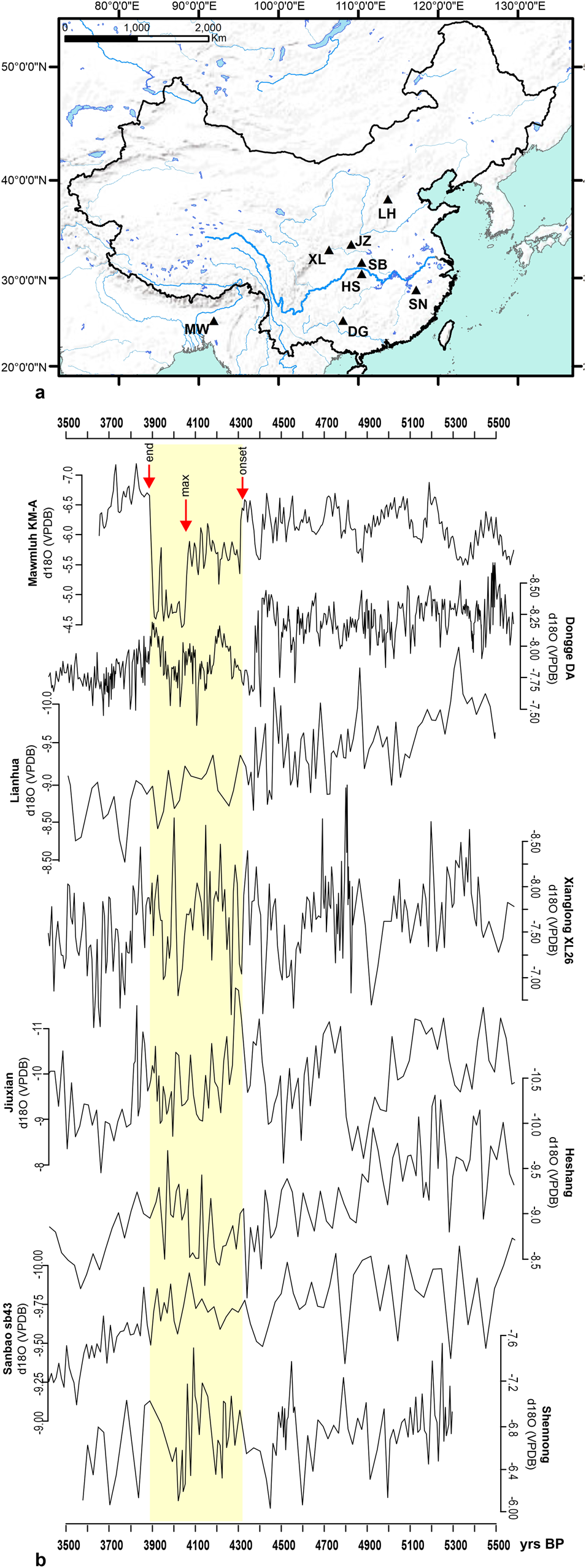
Figure 1. (a) Location and (b) δ18O records of selected speleothems. After H. Zhang et al. (Reference Zhang, Cheng, Cai, Spotl, Kathayat, Sinha, Edwards and Tan2018). MML, Mawmluh Cave speleothem KM-A (Berkelhammer et al., Reference Berkelhammer, Sinha, Stott, Cheng, Pausata and Yoshimura2012), the red arrows indicate onset, maximum, and end of the 4.2 ka event; DG, Dongge Cave speleothem DA (Wang et al., Reference Wang, Cheng, Edwards, He, Kong, An and Wu2005); LH, Lianhua Cave (Dong et al., Reference Dong, Chuan-Chou, Xinggong, Hao-Cheng and Xiuyang2015); XL, Xianglong speleothem XL26 (L. Tan et al., Reference Tan, Han, Cao, Chang-Huang, Mao, Liu and An2018); JX, Jiuxian (Cai et al., Reference Cai, Tan, Cheng, An, Edwards, Kelly, Kong and Wang2010); HS, Heshang (Hu et al., Reference Hu, Henderson, Huang, Xie, Sun and Johnson2008); SB, Sanbao speleothem sb43 (Dong et al., Reference Dong, Wang, Cheng, Hardt, Edwards, Kong and Wu2010); SN, Shennong (H. Zhang et al., Reference Zhang, Pollard, Rawson, Huan, Liu and Tang2019). (For interpretation of the references to color in this figure legend, the reader is referred to the web version of this article.)
East Asia gained a central position in palaeoclimatological studies in light of the relevance of the East Asian summer monsoon (EASM) to the global climatic system and the rich paleoclimatic record available for its study (Wang et al., Reference Wang, Wnag, Cheng, Fasullo, Guo, Kiefer and Liu2014). Major issues still remain, however, such as the case of the phase/out-of-phase relationship between the arid and monsoonal regions of East Asia (Chen et al., Reference Chen, Yu, Yang, Ito, Wang, Madsen and Huang2008), or the synchronous/asynchronous evolution between the ISM and EASM (Li et al., Reference Li, Mo, Kidder, Zhang, Wang and Wu2014). At least in part, those problems stem from the nature of the available evidence itself. The rich speleothems record from China provides high-resolution and well-dated sequences, but the climatic interpretation of this record remains debated (Maher, Reference Maher2008; Wang et al., Reference Wang, Wang and Wu2008; Pausata et al., Reference Pausata, Battisti, Nisancioglu and Bitz2011; Z. Liu et al., Reference Liu, Wen, Brady, Otto-Bliesner, Yu, Lu and Cheng2014). On the other hand, limnic deposits often rely on poor chronologies in terms of the number of radiocarbon dates available and/or materials subjected to AMS determination (i.e., bulk samples in Xiao et al. [Reference Xiao, Zhang, Fan, Wen, Zhai, Tian and Jiang2018]), making a chronological synchronization between different sequences highly problematic, as is the evaluation of the underlying spatiotemporal patterns at a fine chronological scale. In short, even if a climatic disruption associated with the 4.2 ka BP event might be expected in East Asia, the nature, intensity, and spatiotemporal variations of the phenomenon are still not fully understood.
H. Zhang et al. (Reference Zhang, Cheng, Cai, Spotl, Kathayat, Sinha, Edwards and Tan2018) recently reviewed speleothems data from East Asia in relation to the 4.2 ka BP event. In agreement with L. Tan et al. (Reference Tan, Han, Cao, Chang-Huang, Mao, Liu and An2018), the authors proposed the presence around 4.2 ka of dry events in northern (Linhua and Nuanhe caves) and southwestern (Dongge, Dark, Shigao, and Xianren caves) China, to be contrasted with a wet phase in the southcentral (Jiuxian, Xianglong, Sambao, and Heshang caves) and southeastern (Shennong and Xiangshui caves) regions. The border between those contrasting patterns is located by the authors between the northern rim of the Qinling mountains and the lower reaches of the Yangtze River (H. Zhang et al., Reference Zhang, Cheng, Cai, Spotl, Kathayat, Sinha, Edwards and Tan2018; Figure 1b). The southward migration of the ITCZ and of the Northern Hemisphere westerlies jet, due to changes in the Atlantic circulation system, are proposed as the underlying causes of the weakening of the ISM and EASM. Consequently, the rain belt associated with the latter migrated southward, stationing longer in central and southern China (wet) but reaching only in a limited extent regions more inland to the north and west (dry). The reconstruction offered by H. Zhang et al. (Reference Zhang, Cheng, Cai, Spotl, Kathayat, Sinha, Edwards and Tan2018) must be considered against the still open debate on the climatic interpretation of the Chinese speleothem isotopic record (e.g., Maher, Reference Maher2008). Pending further studies, it remains crucial to delineate spatiotemporal patterns, pointing to the presence of different macroregional and regional trajectories, reflecting the complexities and systemic nature of the climatic system. Furthermore, within this complex picture, even for those regions such as northern China, if a climatic disruption associated to the 4.2 ka BP event was detected (H. Zhang et al., Reference Zhang, Cheng, Cai, Spotl, Kathayat, Sinha, Edwards and Tan2018) the magnitude of the event and its impact on local ecologies are far from clear.
A CRITIQUE OF THE CURRENT ARCHAEOLOGICAL APPLICATION OF THE 4.2 KA BP CLIMATIC EVENT
Themes and problems
In linking climate change to human response in East Asia we have to ask what changed? When? Where and for how long? Was it a 4.2 ka or a 4.0 ka event? If there was a global or hemispheric climatic event what were its local effects? Were these compounded or ameliorated by millennial-scale climate processes? Are north, central, and south China in phase or out of phase? All of these questions are points of contention. Just how well understood is the ancient climate to which archaeologists are attempting to link their human behavioral residues? At what resolution does it need to be understood to model the rise or fall of a regional tradition, a polity, or an urban center? Turning the larger question of climate change and human response around, if we start with people, the climate effects that matter are local, the main point of contact is food production systems, and the major factor in resilience is sociopolitical organizations. In other words, to reconstruct human response to change in rainfall or temperature, we need to model what impact those changes had on the environment, including on agricultural production. Thus, a thorough understanding of ancient agricultural systems is a fundamental requirement and not just a desirable accessory. Moreover, if human response is meant to include more than just food production choices, sociopolitical organization is crucially relevant. One cannot talk about the causes of collapse after all, if the thing that purportedly collapsed was never understood in the first place. Recent archaeological approaches to collapse and resilience show that sociopolitical institutions have a spectrum of robustness, and responses to challenges show a range of flexibility and effectiveness (McAnany and Yoffee, Reference McAnany and Yoffee2010; Cowgill, Reference Cowgill, Nichols and Pool2012; Faulseit, Reference Faulseit2016). If climate impacts are an input and migration, demographic decline or collapse are outputs, the sociopolitical institutions in between cannot be left as a black box or the result is correlation, not causation. A related conceptual problem with much of the literature on the 4.2 ka BP event in Chinese archaeology is the loose understanding of collapse. What actually collapsed? Is it the highest stratum of society, leading to a more egalitarian (but less archaeologically visible) reorganization in a scenario where elite excess became too expensive in the face of economic pressure? Or perhaps deurbanization when the demands of provisioning large-scale population centers overwhelmed food production and distribution mechanisms. Or is it a regional demographic decline with people starving to death and/or migrating? Each of these possibilities has different material cultural correlates and could potentially be documented. They should not, however, be treated as if they were the same phenomenon (Renfrew, Reference Renfrew1984, pp. 367–369).
Case studies
To illustrate these points, let us consider three regions spanning the end of the late third millennium and the early second millennium BC—i.e., during the period hypothetically corresponding to the 4.2 ka BP event and its aftermath (Figure 2). The first is the Lower Yangzi River area, where the 4.2 ka BP event is claimed to had a prominent role in culture change narratives. This area was home to the Liangzhu culture, which flourished from ca. 3300 to 2200 BC, its 1000-yr-old civilization apparently disappearing with the onset of the 4.2 ka BP event. A huge literature has grown up linking the demise of Liangzhu to everything from floods, marine regression and rising ground water, to cool temperatures and droughts (e.g., Yu et al., Reference Yu, Zhu, Song and Qiu2000; Zhang et al., Reference Zhang, Zhu, Liu and Jiang2005; Wu et al., Reference Wu, Li, Zhu, Li and Li2012; Long et al., Reference Long, Qin, Atahan, Mooney and Taylor2014; Wu et al., Reference Wu, Zhu, Zheng, Ma, Wang, Li, Li and Li2014; Liu et al., Reference Liu, Wang, Chen, Wu, Mo, Liu, Xu and Zhuang2017; Renfrew and Liu, Reference Renfrew and Liu2018). Thus, Wu et al. (Reference Wu, Zhu, Zheng, Ma, Wang, Li, Li and Li2014, p. 683) claim that, “The cold and drought caused by this climatic event had extremely adverse effects on rice growing”, while Long et al. (Reference Long, Qin, Atahan, Mooney and Taylor2014) claim that profound hydrological changes manifested in the formation of Lake Taihu ca. 4600 cal yr BP indicate an increased risk of flooding. On the other hand, Wu et al. (Reference Wu, Li, Zhu, Li and Li2012) note that current research indicates that Lake Taihu did not form until 3000–2000 cal yr BP, more than 1000 yr after the disappearance of Liangzhu. Clearly, Liangzhu's demise seems to attract environmental explanation, no matter the kind, no matter the evidence. At the same time, although Liangzhu culture was first named in the 1930s, the recognition of its complexity and scale has only begun to be appreciated with the discovery of Liangzhu's walls and regional water control system (Liu et al., Reference Liu, Sun, Thomas, Zhang, Finlayson, Zhang, Chen and Chen2015; Reference Liu, Wang, Chen, Wu, Mo, Liu, Xu and Zhuang2017; Renfrew and Liu, Reference Renfrew and Liu2018). The nature of the polity and the regional political economy, moreover, is in its infancy, as is work on its agricultural systems. Indeed, the most thorough multi-proxy study of field systems (albeit at a single location) published to date (Zhuang et al., Reference Zhuang, Ding and French2014; Weisskopf et al., Reference Weisskopf, Qin, Ding, Sun and Fuller2015) showed an intensification of agricultural production in the late Liangzhu period and the development of paddy field rice production toward the end of this phase under wetter conditions. Zhuang et al. (Reference Zhuang, Ding and French2014) claim the paddyfield dates at Maoshan mostly fall into the 4700–4200 cal yr BP period, but give 4500–4000 cal yr BP for the late Liangzhu period. Qin (Reference Qin and Underhill2013), on the other hand, gives 2600–2400 BC for the late Liangzhu, calls 2400–-2200 BC “epi-Liangzhu,” and claims that the occupation of the Liangzhu site cluster “reached its peak in during the middle Liangzhu (c. 3000–2600 BC)”. Liu et al. (Reference Liu, Wang, Chen, Wu, Mo, Liu, Xu and Zhuang2017, p, 13640) claim that Liangzhu's massive dam system was completed in the early Liangzhu phase and “the construction of most of Liangzhu city dated at 4900–4600 cal B.P.,” the middle Liangzhu period to which most of the elite cemeteries date and when the regional system centered on Liangzhu was at its apogee (Qin, Reference Qin and Underhill2013, pp. 581–584). The late Liangzhu period saw a proliferation of small sites, diversity, and a breakdown of the regional system (Qin, Reference Qin and Underhill2013, p. 586). Liu et al. (2018) associate the end of Liangzhu center with clay deposits that “represents massive flooding in the region, possibly occurring in multiple events starting around 4,200y B.P. or shortly thereafter” with small-scale occupation until “approximately 3,800 cal B.P.” (p. 13641).
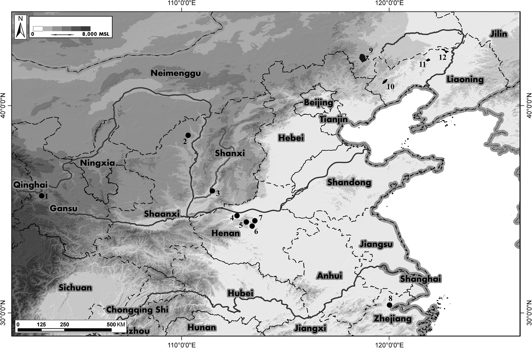
Figure 2. Modern-day provinces and sites mentioned in the text: (1) Qijiaping, (2) Shimao, (3) Taosi, (4) Erlitou, (5) Wangchenggang, (6) Wadian, (7) Xinzhai, (8) Liangzhu, (9) Chifeng survey, (10) Daling survey, (11) Fuxin survey, and (12) Zhangwu survey.
To summarize, it appears that the Liangzhu center and its regional political economic system were possibly in decline centuries before the 4.2 ka BP event while population increased and agriculture intensified. In this flood-prone area, flooding, the ultimate cause of which remains controversial, is associated with the ultimate decline of the site and this regional culture which had been intensively occupying the landscape for approximately 1000 yr before its decline. At this point, with so much unknown, the particular linkages between climate change, environmental stress, agricultural impacts, and human response are unclear. Currently we know next to nothing about the nature of the political system, economic mechanisms, or food production regimes. The anthropogenic impact on the environment of a millennium of logging and burning has not been addressed (see also Zhuang et al., Reference Zhuang, Ding and French2014). Furthermore, the nature of the environmental change remain unclear: catastrophic flooding or droughts (or both)? Much basic, systematic work is needed before the apparent demise of the Liangzhu culture can be understood, and certainly before linking it to a specific climatic cause.
The second case is the site of Shimao at the northern edge of the Shaanxi loess plateau at what is now the north-western margin of the EASM domain. Recent, systematic archaeological work has uncovered a massive walled center at Shimao and a regional system of thousands of related sites dating to 2300–1800 BC, a cultural florescence in what should have been an environmentally vulnerable area in the middle of the purported 4.2 ka BP climate apocalypse. Paleoclimatic research and OSL dating in the nearby Mu Us desert shows that, despite a general cooling and drying trend beginning at 4.6 ka, 4.1–3.7 ka was relatively warm and wet (B. Liu et al., Reference Liu, Jin, Sun, Sun, Niu, Xie and Li2014). The return to dry, cool conditions at 3.7 cal ka BP is then said to be the cause Shimao's decline (Sun et al., Reference Sun, Shao, Liu, Cui, Bonomo, Guo, Wu and Wang2018), and, remarkably, B. Liu et al. (Reference Liu, Jin, Sun, Sun, Niu, Xie and Li2014, p. 117) claim that the drying episodes were related to a weakened EASM and that: “the Holocene millennial-scale dry events were possibly controlled by the climatic changes in the low and high latitudes of the Northern Hemisphere, reflecting a prominent synchronism in the climatic and environmental changes at the regional and global scales”. In other words, the authors are claiming that not only was 4.1–3.7 ka a warm and wet period between “dry events”, but that this pattern was due to forcing mechanisms of global extent.
Clearly there is a problem with aligning the Mu Us OSL data with other proxies for the 4.2 ka BP event that is being papered over, or at least its characterization as a cool, dry period. On the archaeological side of things, the linkage of Shimao's eventual decline to climate change, while plausible, is at best a preliminary correlation given its location, albeit one that seems to have nothing to do with a putative 4.2 ka BP event. With archaeological work in its infancy at the site (Jaang et al., Reference Jaang, Sun, Shao and Li2018; Owlett et al., Reference Owlett, Hu, Sun and Shao2018; Sun et al., Reference Sun, Shao, Liu, Cui, Bonomo, Guo, Wu and Wang2018), we currently understand little about Shimao's food production regime and therefore are in no position to model the impact of temperature and rainfall changes on it (even if we knew what they were). Eventually, factors such as anthropogenic impacts on the environment through deforestation and over-grazing need to be incorporated. What was the social and political organization of Shimao like? What strategies were available to deal with bad economic years? What was the response of food producers and political leaders to cooling, drying conditions? What are the other possible factors that might have led to Shimao's decline? Basically, at this stage of research, answers to any of the questions above are necessarily speculative and the 4.2 ka BP event functions as little more than a convenient narrative frame, and not even one that lines up chronologically. Shimao, was, after all, the largest site of its time discovered thus far in East Asia, located in an environmentally fragile area and yet it reached its zenith during the time of the supposed 4.2 ka BP event.
If Shimao rose and flourished and Liangzhu disappeared around 4.2 ka, the Central Plains trajectory, the third case, seems to be one of unbroken development. Large sites such as Wangchengang, Wadian, Xinzhai, and Erlitou arose and flourished in the period between 2200 and 1600 BC against a background of increasing regional site density in the areas that have seen systematic survey (Underhill et al., Reference Underhill, Feinman, Nicholas, Fang, Luan, Yu and Cai2008; Zhao et al., Reference Zhao, Zhang, Gu, Xie and Qian2009; Zhuang et al., Reference Zhuang, Zhang, Fang and Wang2017). In addition, due to the focus of Chinese archaeology on areas associated with the first dynasties of the historiographic record, the Central Plains has seen much more work than other areas and consequently we are in a better position to examine effect of climate on food production. The general pattern is one of diversification and extensification (Yuan et al., Reference Yuan, Campbell, Castellano and Chen2020). During this period, Eurasian exchange domesticates such as sheep, goat, cattle, and wheat were added to the original North China pig-dog-millets economy along with soy and rice (Yuan and Campbell, Reference Yuan and Campbell2008; Flad et al., Reference Flad, Li, Wu and Zhao2010; Cai et al., Reference Cai, Sun, Tang, Hu, Li, Zhao, Xiang and Zhou2014). The diversification of domesticates allowed risk mitigation as well as expanded the environmental niches utilized (d'Alpoim Guedes et al., Reference d'Alpoim Guedes, Manning and Bocinsky2016). This is especially true of cattle and sheep, which can more efficiently utilize grasses. Isotopic research has indicated that even sheep and cattle followed different husbandry strategies, and their introduction created new possibilities for field rotation systems and secondary products such as dung fuel, wool and traction (Makarewicz and Sealy, Reference Makarewicz and Sealy2015; Yuan et al., Reference Yuan, Campbell, Castellano and Chen2020). While more work is needed to link these agricultural developments to local political economies and both, in turn, to climate, it is uncontroversial to state that the 4.2 ka BP event either had little negative local climatic impact on the Central Plains or that its impact was thoroughly ameliorated by political economic responses.
Collectively, these three cases show that not only has the 4.2 ka BP event been invoked in an ad-hoc fashion, but the complexity of the problem of human response to environmental change has not been adequately appreciated in Chinese archaeology. Fundamental to many of these studies is the tendency to correlate diverse data sets of inadequate resolution or mismatching scale. This is nowhere more apparent than the widespread attempts to use the Atlas of Chinese Cultural Relics to tune paleoclimatic proxies with demographic change.
Archaeology and reality: Tuning and the Atlas of Chinese Cultural Relics
Tuning (aka wiggle matching or record and event aligning) is often used to inspect a range of paleoclimatic proxies and propose syncretism between events. There are a number of approaches to wiggle matching in climate data, each with their own set of challenges and limitations, themselves a product of the spatiotemporal resolution of climate proxies being used (Blaauw, Reference Blaauw2012; Lowe and Walker, Reference Lowe and Walker2014, pp. 366–367). As an off-shoot of this approach, archaeological and historical data can be subsequently plotted onto schematic representations of tuned climatic processes to reveal coinciding trends between social developments and climate changes (e.g., Zhang et al., Reference Zhang, Cheng, Edwards, Chen, Wang, Yang and Liu2008; Büntgen et al., Reference Büntgen, Tegel, Nicolussi, McCormick, Frank and Trouet2011; Kelly et al., Reference Kelly, Chipman, Higuera, Stefanova, Brubaker and Hu2013). Scholars have pointed out the limitations of these approaches and the difficulty in establishing synchronicity between climate events and social change to establish causal relationships between the two (e.g., Butzer and Endfield, Reference Butzer and Endfield2012; Kintigh and Ingram, Reference Kintigh and Ingram2018; Jaffe et al., Reference Jaffe, Bar-Oz and Ellenblum2019). Nevertheless, its application has been central to human-environmental studies in archaeological circles worldwide (Carleton and Collard, Reference Carleton and Collard2020).
In China, the most ubiquitous repository of archaeological data used for creating a demographic trajectory (i.e., correlated and integrated with the paleoclimate changes in wiggle matching models) comes from the Atlas of Chinese Cultural Relics. The Atlas is a crowning achievement of the State Administration of Cultural Heritage, amassing information obtained from previous surveys and major discoveries. Beginning in the 1950s, huge survey and excavation campaigns were initiated throughout the newly formed People's Republic of China. The atlases concisely document this data to provide maps of site location for the different periods as well as tables that briefly describe each site: archaeological cultures identified, a rough estimate of the site size, and a list of ceramic types found in it. In most cases, even such rudimentary information is incomplete. To date, 32 volumes have been published, one for each province, autonomous region, or municipality in China.
A growing number of studies in the past few years have utilized these data to provide insights into impacts of climate change on human societies in prehistoric China (see Introduction). The assumption of these studies is that by comparing the number of sites before and after an apparent paleoclimatic event it is possible to understand its effects on parameters such as the density of population as well as on settlement dynamics. The Qijia's 齐家 rise and demise provides an illustrative example for such use and the problems inherent in an uncritical use of Atlas data.
The Qijia archaeological culture refers to a shared ceramic production tradition dated to the late third and early second millennium BC and found in eastern Qinghai, Gansu, southern Ningxia, and parts of the Inner Mongolia autonomous region. The Qijia culture is the focus of studies investigating the introduction of new domesticates and commodities, such as sheep, goats, and metallurgy. Some have even proposed connections to the development of the supposed first state at Erlitou (overview in Liu and Chen [Reference Liu and Chen2012]). The so-called collapse of the Qijia culture has been dated to the end of the third millennium BC and identified archaeologically with the sharp decline in the number of sites attributed to the cultures that succeeded it in the same regions: namely Xindian, Kayue, Siwa, and Siba. The decline of the Qijia is often explained by the onset of the 4.2 ka BP climatic event. It is believed that the climatic deterioration caused the sedentary agriculturalist societies of the Qijia to transition to mobile and pastoral subsistence (Xu, Reference Xu1988; Mo et al., Reference Mo, Li, Li and Kong1996; Shui, Reference Shui2001; Wu and Liu, Reference Wu and Liu2004; An et al., Reference An, Tang, Barton and Chen2005; Hou et al., Reference Hou, Liu, Liu and Fang2009; Liu and Feng, Reference Liu and Feng2012; Dong et al., Reference Dong, Jia, Elston, Chen, Li, Wang, Cai and An2013a; Wagner et al., Reference Wagner, Tarasov, Hosner, Fleck, Ehrich, Chen and Leipe2013).
Hundreds of archaeological sites of the Qijia and later cultures have been identified over the past few decades. Yet, to date, very few Qijia habitation sites have been excavated and published (Womack et al., Reference Womack, Jaffe, Zhou, Hung, Wang, Li, Chen and Flad2017). While many Qijia sites are recorded in the Gansu (and other) volumes of the atlas of cultural relics, they were found through unsystematic surveys and sporadic salvage excavations. Consequently, despite the impression created by these papers (Figure 3 is an example of Atlas data tabulated for the Tao River valley in Gansu), namely that climatic change caused a demographic decline in the region previously populated by the Qijia communities, there are a number of methodological problems underlying this conclusion.

Figure 3. The number of late Neolithic and Bronze Age sites and their archaeological dates reported by the atlases in the Tao River valley region in Gansu province, the so-called center of Qijia culture.
Because of the unsystematic nature of the archaeological work, the suitability of the numbers provided by the Atlas of Chinese Cultural Relics for demographic trend reconstruction needs to be critically evaluated. Most sites have been found as a result of urban development projects, or target surveys along riverbanks. Thus, where roads and cities were constructed, many sites were found, while in others (where less development has taken place) few or no sites were found. Therefore, one cannot take existing data to faithfully mirror ancient settlement patterns. At best, this data provide a fragmented picture of possible changes in those limited areas where archaeological work has been done (Figure 4).
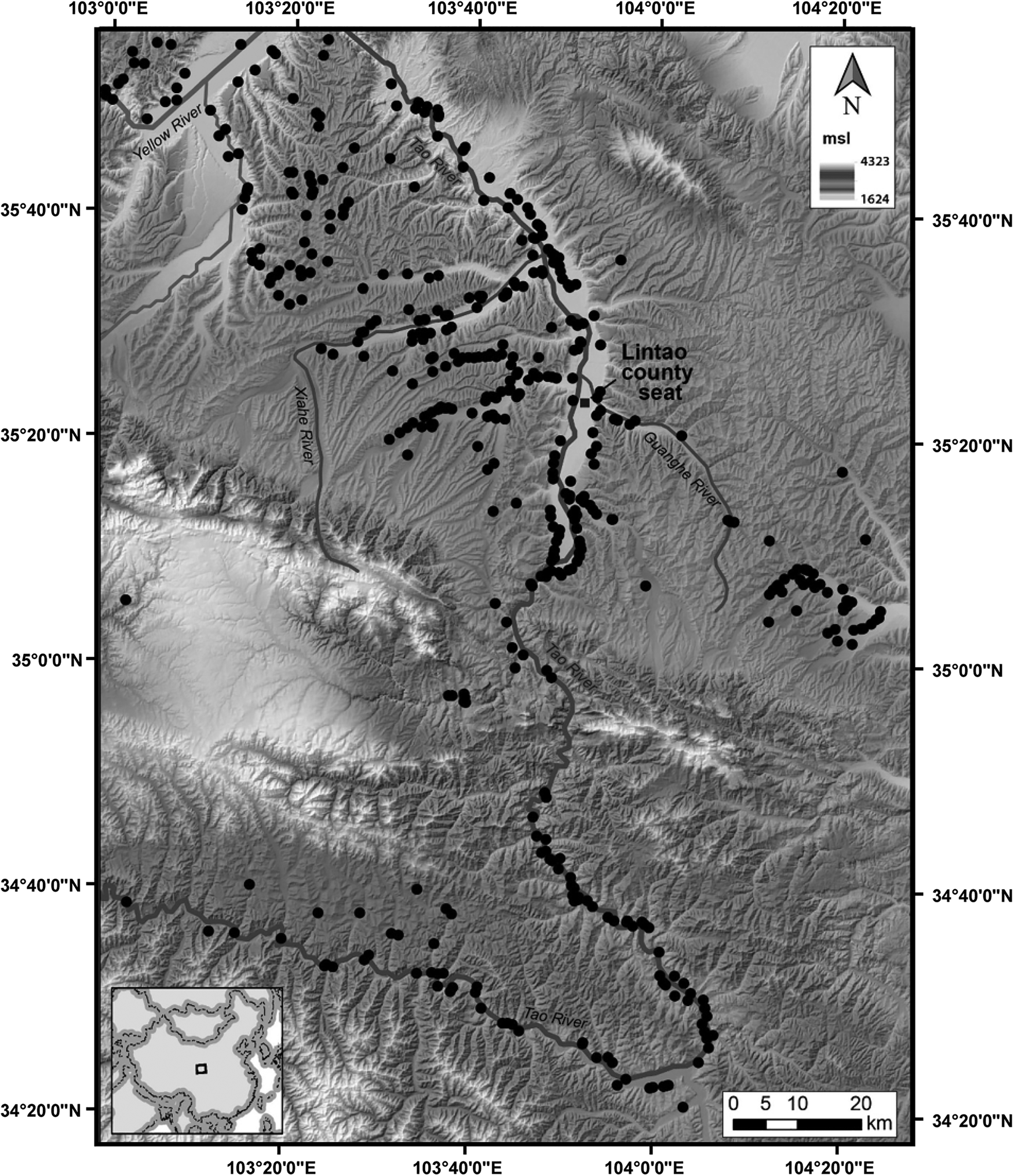
Figure 4. Atlas-generated sites from the Qijia and later periods in the Tao River. Note distribution of sites reflects where work has been done: mostly rivers, rather than actual ancient settlement preference. Work in Lintao has been more extensive than other counties in the region. After Jaffe and Flad (Reference Jaffe, Flad, Boivin and Frachetti2018, p.144)
A second problem is that atlases, and the majority of the above studies that use their data, treat the archaeological site as binary human occupation indicator. Hence, they are plotted on maps as mere points with no consideration given to the size of the site, the density of artifacts found, or the type of relics that were documented in that location. Few Qijia sites documented in the Atlas have been studied in any extensive or systematic way. Most are recordings of Qijia style ceramic finds and until excavated (or at least systematically and intensively surveyed) little can be said regarding social, political or economic information. For example, for the Qijiaping site (the Qijia culture type-site) the Atlas merely notes: size of 12,000 m2; a propensity for orange/brown ceramics color or dark-grey; cord marking decorations; and an ubiquity of guan, pen, and zun ceramic types (Bureau of National Cultural Relics, 2011, p.765). This information can represent many different things. Because archaeologists use the term “site” in a rather open-ended manner to denote: “a distinct spatial clustering of artifact, structures, or organic and environmental remains—the residue of human activity” (Renfrew and Bahn, Reference Renfrew and Bahn2018, p. 603), Qijiaping and any of the data points recorded in the atlases, can represent anything from a small ceramic scatter, several looted graves, large areas of dense finds and architectural remains, or a large excavated city.
Another connected problem has to do with the definition (and understanding) of archaeological cultures. The prevailing view in many studies is that the existence of similar ceramic styles is not only a chronological marker, but also reflects a neatly bounded group of people (usually shorthand for ethnic group), who shared similar beliefs and who were part of the same sociopolitical constellation. In other words, when ceramic styles change, people and polities (and even civilizations) are thought to have disappeared along with them or replaced by a new group of people. However, ceramic styles are rarely associated with ethnic or political affiliations. They usually reflect no more than shared production traditions, especially when the actual political, economic, and other basic organization of these communities who used them is almost never known (Terrel, Reference Terrell2001; Lucy, Reference Lucy, Díaz-Andreu García, Lucy, Babic and Edwards2005). Moreover, new ceramic styles are often the results of internal dynamics where no social collapse, site abandonment or a movement of a new group is needed as an explanatory model (Harris and Cipolla, Reference Harris and Cipolla2017).
Finally, and perhaps most problematic, the atlases provide limited info on the chronology of the sites they document. Studies often view sites that yielded a particular ceramic style to have been established and abandoned in exact correspondence to the chronological range of the archaeological “cultures” represented in the findings, thus giving the illusion that they all rose and collapsed at the same time. Such a picture lends itself to the reconstruction of very rapid and complete collapse as well as replacement of one culture by another culture. Because the Atlas provides a date range of 2200–2000 BC for the Qijia culture, studies that use Atlas data take this to mean that all Qijia period sites were abandoned, simultaneously, at the end of the third millennium BC, and suggest a sudden and total collapse of the Qijia. All survey data, systematic or not, struggle with these issues and only carefully excavated sites can address these limitations.
In reality, archaeological ceramic date ranges reflect only the total amount of time a ceramic style was used at all sites combined. It cannot provide, on its own, the precise date from the establishment to abandonment of any given site. This is to say, that without excavating a site, we have no way to know if most Qijia sites were abandoned several decades before the climate event rendering the actual effect of the 4.2 ka BP climate event irrelevant in comparison to internal social processes. The dating of the supposed Qijia collapse makes this effort all the more problematic, as there is a disagreement among scholars as to the chronological dates of the Qijia ceramic style. It is variously reported (in each study) to have been dated to cal. 4300–3900 cal yr BP (An et al., Reference An, Tang, Barton and Chen2005), or 4000–3800 cal yr BP (Liu and Feng, Reference Liu and Feng2012), and even to 4000 to 3600 cal yr BP (Liu et al., Reference Liu, Zhang, Feng, Hou, Zhou and Zhang2010; dates are reported here in the format provided in the original publications, although likely do not originate exclusively from radiocarbon dating). Consequently, if for An et al. (Reference An, Tang, Barton and Chen2005) Qijia cultural florescence collapses as a result of the 4.2 ka BP event, Liu and Feng (Reference Liu and Feng2012) view Qijia society to have existed, somehow, as agriculturalists, for another two centuries after it. Finally, for Liu et al. (Reference Liu, Zhang, Feng, Hou, Zhou and Zhang2010) Qijia people never enjoyed favorable environmental conditions and the prolonged effects of climatic change (over 400 yr!) brought about the subsequent transition to nomadic pastoralism.
In sum, none of these assumptions are based on much more than matching the number of Atlas-recorded-sites to a putative climatic event. As we demonstrated, the matching itself is problematic, because the dates of both the archaeological sites and the climatic event are not well defined, let alone the casual connections between the two. Indeed, to date only a handful of Qijia residential sites have been excavated, leading to only cursory information on the nature of Qijia sociopolitical characterizations. Most recently, work in the Tao River valley has questioned the ca. 2000 BC end date for Qijia archaeological culture as woefully inaccurate. Qijia culture ceramics are now viewed to have dates between 2300–1500 BC, as in the recent excavations at the Qijiaping site (Womack et al., Reference Womack, Jaffe, Zhou, Hung, Wang, Li, Chen and Flad2017), where direct C14 dating of samples obtained from carefully excavated strata have in fact yielded dates to the sixteenth century BC (Brunson et al., Reference Brunson, Ren, Zhao, Dong, Wang, Zhou and Flad2020, table 4). Thus, like Shimao, the Qijia archaeological culture seems to flourish during the so-called 4.2 ka BP event. In contrast to the commonly accepted image of the Qijia as a highly stratified society, cemetery remains (where almost all Qijia-related data derive from) point to a modest amount of inequality among Qijia communities and varying degrees of ceramic craft specialization between them (Chen Reference Chen and Underhill2013; Womack et al., Reference Womack, Jaffe, Zhou, Hung, Wang, Li, Chen and Flad2017; Jaffe and Flad, Reference Jaffe, Flad, Boivin and Frachetti2018). Consequently, when considering the “collapse” of the Qijia it is not at all clear what this entailed.
Lessons from systematic surveys in Northeast China
While we have laid out the problems regarding the use of Atlas data for the Qijia archaeological culture and highlighted the 4.2 ka BP event, such problems are not limited to this issue alone. For China's many other periods, Atlas data is mustered to establish casual mechanisms between environmental change and human responses throughout the Holocene (e.g., An et al., Reference An, Feng and Tang2004; Liu et al., Reference Liu, Zhang, Feng, Hou, Zhou and Zhang2010; Dong et al., Reference Dong, Wang, Cui, Elston and Chen2013b; Guo et al., Reference Guo, Mo, Mao, Jin, Guo and Mudie2014; Li et al., Reference Li, Liu, Cui, Ren, Storozum, Qin, Wang and Dong2017; Jia et al., Reference Jia, Li and Fang2018; Tan et al., Reference Tan, Cai, Cheng, Edwards, Gao, Xu, Zhang and An2018; J. Zhang et al., Reference Zhang, Wang, Yang, Li and Zhang2019).
The problems inherent in the data provided by the Atlas are made clearer by comparing it to data acquired through systematic regional surveys. Because systematic regional surveys use consistent methodology and fully cover the area on which they report, the data they generate is free from many of the biases of the Atlas data discussed above. The past two decades have seen a number of large, full-coverage, systematic pedestrian surveys of regions in Northeast China, notably the Chifeng International Collaborative Archaeological Research Project (CICARP; 2011) international survey project, the Upper Daling river valley project (Peterson et al., Reference Peterson, Lu, Drennan and Da2014) the Zhangwu regional survey in Liaoning province (Williams, Reference Williams2014) and the Fuxin regional survey (Shelach-Lavi et al., Reference Shelach-Lavi, Teng, Goldsmith, Wachtel, Ovadia, Wan and Marder2016). This is an unique situation, as nowhere else in China do systematic regional surveys exist at such a scale. It provides an exceptional dataset with which to examine dynamics of population change, the spatial distribution of habitation sites, economic strategies, and political make up of communities spanning more than 7000 yr. Moreover, comparing the results of this extensive dataset to that of the archaeological atlases highlights the problems inherent in relying on Atlas data alone.
A paper recently published by Jia Xin and his colleagues (Reference Jia, Lee, Zhang, Wang, Sun, Zhao, Yi, Huang and Lu2016) is a good example for the use (or perhaps misuse) of the data in the archaeological atlases to chart demographic trajectory and economic trends. Based on the Atlas of Chinese Cultural Relics, Inner Mongolia volume (Bureau of National Cultural Relics, 2003), Jia et al. (Reference Jia, Lee, Zhang, Wang, Sun, Zhao, Yi, Huang and Lu2016) argue for a dramatic change that took place at the end of the second millennium BC—corresponding to a global climatic event (3500–2500 cal BP in Mayewski et al. [Reference Mayewski, Rohling, Stager, Karlen, Maasch, Meeker and Meyerson2004]), the historical impact of which has already been extensively debated in other cultural and geographic contexts (in particular in the eastern Mediterranean scholarship, literature and critique is provided in Knapp and Manning [Reference Knapp and Manning2016]). According to Jia and colleagues’ reconstruction, at the beginning of this period, during the Lower Xiajiadian period (LXJD, ca. 2200–1200 BC), the region experienced an unprecedented zenith in the density of occupation. A dramatic decline in the number of sites and their density (from 3064 to 725) occurred around the end of the second or beginning of the first millennium BC, with the onset of the Upper Xiajiadian (UXJD, also known as Gaotaishan) period (Jia et al., Reference Jia, Lee, Zhang, Wang, Sun, Zhao, Yi, Huang and Lu2016, pp. 786–787). This dramatic change is associated, according to them, with the decline of millet-based agriculture and the deterioration of climatic conditions. However, the factual base of this reconstruction is contradicted by the findings of the four systematic regional surveys conducted in the same region (Figure 5).

Figure 5. (color online) Distribution of Xijiadian (lower left and upper right) collection units in four systematic surveys in Northwest China. (1) Chifeng, (2) Daling, (3) Zhangwu, and (4) Daling. Compare continuation of settlement occupation and increase of intensity for three of the four surveys, with Jia et al.'s (Reference Jia, Lee, Zhang, Wang, Sun, Zhao, Yi, Huang and Lu2016) reconstruction, based on Atlas data, which argued for a marked population decrease in the transition from the Lower to the Upper Xijiadian period. After Chifeng (Reference Chifeng2011), Peterson et al. (Reference Peterson, Lu, Drennan and Da2014), Shelach et al. (Reference Shelach-Lavi, Teng, Goldsmith, Wachtel, Ovadia, Wan and Marder2016), and Williams (Reference Williams2014). All data accessed from http://www.cadb.pitt.edu.
The CICARP, carried out between 1998 and 2007, focused on the Chifeng area (赤峰) of Inner Mongolia, located at the heart of the distribution of the Lower and Upper Xiajiadian cultures. The systematic regional survey conducted by this project is not only one of the largest ever to be conducted in China, covering an area of more than 1,000 km2, but also set the methodological standard for most of the surveys that have since been conducted in China (Chifeng, Reference Chifeng2011). Unlike the unsystematic nature of data collected for the Atlas of Chinese Cultural Relics, the Chifeng survey methods emphasize full pedestrian coverage of the entire survey area and systematic documentation not only of the number of sites but also the size of any concentration of artifacts (potsherds and stone tools) as well as the density of surface artifacts at those sites. This method resulted in a large data set that documents the distribution of artifacts over the landscape and allows, among other things, for relatively accurate demographic estimates (for methods of converting survey data to population estimates see Chifeng [Reference Chifeng2011, pp. 57–79] and Drennan et al. [Reference Drennan, Berrey and Peterson2015]). The results of the Chifeng survey demonstrate that in this region the Lower Xiajiadian (ca. 2000 to 1200 BC) was indeed one of the demographic peaks of the trajectory from the early Neolithic to the Imperial era. However, in contrast to the finds generated by the Atlas as reported by Jia et al., during the Upper Xiajiadian period (ca. 1200 to 600 BC), the region was even more densely populated. According to the estimates of the CICARP team, the regional population during the Lower Xiajiadian was between 40,000 to 80,000 while during the Upper Xiajiadian it was between 60,000 to 120,000 people (Chifeng, Reference Chifeng2011, pp. 57–79). The concrete numbers are not as important as the archaeological data that suggest an increase of about 50% in the regional population, in sharp contrast to Jia et al.'s (Reference Jia, Lee, Zhang, Wang, Sun, Zhao, Yi, Huang and Lu2016) model that suggests a decrease of about 400% (Table 1).
Table 1. Population number estimates as a factor of sherd density for each period in the four respective surveys.

Even more dramatic results were obtained by the Fuxin (阜新) regional project. Located west of Chifeng and on the westernmost extent of the distribution of the Lower and Upper Xiajiadian cultures, in eastern Liaoning province, the Fuxin survey used similar survey methods but covered a much smaller area of ca. 105 km2 (Shelach et al., Reference Shelach-Lavi, Teng, Goldsmith, Wachtel, Ovadia, Wan and Marder2016). While the general demographic trajectory is similar to that of the Chifeng region, the transition between the Lower Xiajiadian and Upper Xiajiadian (known locally as Gaotaishan) was even more dramatic: Lower Xiajiadian pottery was found in 105 collection units, while Gaotaishan pottery was found in 1101 collection units. In fact, Gaotaishan sherds were by far the most common sherds found during the Fuxin survey—among the pre-Imperial period sherds almost 80% were Gaotaishan sherds (Shelach et al., Reference Shelach-Lavi, Teng, Goldsmith, Wachtel, Ovadia, Wan and Marder2016, p. 10).
One of the advantages that data obtained by systematic surveys have over the Atlas of Chinese Cultural Relics is the ability to see not only the trajectory of the large-scale region, but also the differences that exist among the trajectories of sub-regions (Figure 5). The full-coverage survey of the Upper Daling (大凌) river valley in Liaoning province shows these results as well. Following a similar methodology practiced in Chifeng and Fuxin surveys, in the Daling survey the UXJD period represent a similar demographic highpoint. Additionally, settlement nucleation, described by Jia et al. (Reference Jia, Lee, Zhang, Wang, Sun, Zhao, Yi, Huang and Lu2016) as declining during the UXJD periods, has been shown to be wrong as well. Autonomies polities recorded for the previous LXJD period did not collapse, but continued to grow during this subsequent period. In fact, based on these finds, only 3% of the population is understood to have lived in outspread farmsteads during the UXJD periods; most people lived in large communities—some of which several thousand strong (Drennan et al., Reference Drennan, Peterson, Xueming, Da and Shenguang2014, pp. 77–79). This is hardly reflective of a nomadic society.
Only in the Zhangwu (彰武) region is a decline in settlement numbers observed during the UXJD period. Yet, this is not taken to reflect a situation of nomadic pastoralism by the surveyors: though total site numbers are smaller, the collection units making up these settlements show a continuation of the previous high densities of ceramic finds in them. In other words, highly nucleated sedentary sites were probably still the norm during the UXJD period in this region as well (Williams, Reference Williams2014, pp. 126–127). In fact, based on the Zhangwu survey results, Williams (Reference Williams2014) argues for a mixed economic strategy, where plant cultivation continued to be an important component of the agricultural economy. This is evidenced by the type and use of stone tools in the region as well as the location of settlements—namely their continued occupation of zones suitable for grain agriculture and proximal to water sources (Williams, Reference Williams2014, pp. 160–161, 166).
Although to date only a few UXJD habitation sites have been excavated, they have produced a large number of stone tools associated with agricultural production and processing of cereals (Zhongguo, Reference Zhongguo1974; Liu and Xu, Reference Liu and Xu1981; Liaoning, Reference Liaoning1983). If anything, stone tools associated with agricultural production increased during the first half of the first millennium BC, as did the number of storage pits (Shelach, Reference Shelach2009). Flotation done at excavated sites in the Chifeng region showed the importance of millet (foxtail and broomcorn) in at both Lower Xiajiadian and Upper Xiajiadian strata (Chifeng, Reference Chifeng2011, p. 33). Renewed analysis of zooarchaeological assemblages have shown that the ratio of sheep/goat to pig and other animals actually decreases during the Upper Xiajiadian period (Chifeng, Reference Chifeng2011, p.129). Thus Upper Xiajiadian societies most likely relied on millet agriculture and domesticated pigs, supplemented by sheep/goat products.
To summarize: the results of the Chifeng and Fuxin regions, as well as the Upper Daling river valley, negate the model that the transition from the Lower to the Upper Xiajiadian period, sometime in the late second or early first millennium BC, is a result of climatic change that caused the deterioration of agricultural production and the transition to a pastoral-based and mobile economy. The Zhangwa survey, which did find a decline of Upper Xiajiadian sites, highlights the importance of evaluating the local specific trajectory of developments. Indeed, the change in settlement numbers and density along with the persistence of agricultural tools hints at a greater social transformation than adoption of economic strategies. As Table 1 shows, when data from the four surveys are calibrated in the same way to estimate the amount of population in a given area over time, results are obtained that show this general trajectory. These results are very different from those reported by studies based on data from the archaeological atlases, and highlight the uniqueness of each one of the survey areas.
DISCUSSION: MOVING FORWARD
The critical evaluation of research on the effects of the 4.2 ka BP event has important repercussions on one of the most crucial issues in Chinese ancient history, considering the common attempt to link this climatic phase to the collapse of all major Neolithic cultures, save one, the Henan Longshan culture, which led to the uncontested development of the first Chinese state (Li Reference Li and Yang2004; Wu and Liu, Reference Wu and Liu2004; Liu and Chen, Reference Liu, Chen and Stark2006; Gao et al., Reference Gao, Zhu and Xu2007; Liu and Feng, Reference Liu and Feng2012; Li et al., Reference Li, Liu, Cui, Ren, Storozum, Qin, Wang and Dong2017; C. Zhang et al., Reference Zhang, Pollard, Rawson, Huan, Liu and Tang2019). However, as we argue, the data used to prove such trajectories are often poorly dated and unsystematically collected, thus the underlying reconstructed social and demographic trends that many identified cannot be substantiated (and see Campbell, Reference Campbell2014; Shelach and Jaffe, Reference Shelach and Jaffe2014). Moreover, the magnitude and perhaps even the existence of the 4.2 ka BP event itself, which are taken for granted in many of those studies, is far from being the “scientific fact” asserted by many authors, with several open questions concerning the nature, chronology, magnitude, and geographic declinations of this climatic event.
What the above cases demonstrate is that (1) the 4.2 ka BP event is often invoked by archaeologists and paleoclimatologists in East Asia when it is convenient and largely ignored when it is not; (2) the 4.2 ka BP event (possibly complicated by millennial-scale phenomena) either had more regionally variable climatic impacts than is normally claimed, or, the impacts were met with both ecological and sociocultural responses that had dramatically different outcomes; (3) we are not yet in a position to reconstruct local food production systems, social organization, or political economic institutions with sufficient granularity in any region of China to say what the human response was to climate change (even in the instances in which the latter can be unambiguously reconstructed with adequate resolution); and (4) a major methodology common to articles claiming paleoenvironment-related ancient Chinese societal collapse, namely the uncritical correlation of archaeological Atlas data with putative climate events is fundamentally problematic. The critique we are making is not exclusive of the 4.2 ka BP case, as we have shown with the UXJD study and the first millennium BC. Having recognized a general problem, we believe it is beneficial to address these issues in general terms by explaining what archaeological data actually are.
The limitations of Atlas (and other) archaeological data
As discussed in the previous sections, the use of data from the Atlas of Chinese Cultural Relics can be misleading. Even if the example we presented from northeastern China is extreme in the degree of discrepancies found between Atlas data and systematic surveys results, it suggests more generally that the Atlas data are not a reliable source to reconstruct the demographic, sociopolitical and economic trajectories of any region in China. This is not to say that the Atlas data is useless. The very fact that data are compiled and reported on is important and should indeed be the standard for all archaeological work. Moreover, the publication of the full data of any archaeological project (rather than mere summary and interpretation of it) in an open-access fashion is a basic step in our ability to correlate ecological conditions with socioeconomic processes (we point out that all data from the four systemic surveys we present above are catalogued in an open-access database and can be found at https://www.cadb.pitt.edu/).
Once we become conscious of the limitations of the data presented in the Atlas of Chinese Cultural Relics, we can use it as a source for information and the preparation for academic research, such as the initial identification of potential sites for excavations.
Understanding the nature of archaeological data, what they are and are not, is key in avoiding mismatches of scale and ultimately conducting better science. There are, in fact, several common misrepresentations of the archaeological data and misunderstandings of the reality they represent (Figure 6):
(1) Research based on Alas data too often assign equal value to sites, i.e., they are understood as equal representative loci of past habitation areas. The archaeological data—often several sherds collected in chance survey—must, however, be fully analyzed (preferably following systematic survey and excavation) in order to apprehend the actual scale and nature of the site (e.g. a graveyard, a hamlet, a workshop, a large city, or a chance broken vessel; Figure 6a).
(2) Research based on Atlas data too often use the data reported in it as representative of a large region, a whole province, or even all of China. These data, however, are not the product of systematic efforts to investigate a landscape evenly and thus they cannot be taken to faithfully reflect ancient settlement patterns or the intensity of occupation throughout the entire region. Archaeological data, must be systematically collected in full-coverage surveys for this argument to be made (Figure 6b).
(3) Research based on Atlas data too often view sites where similar ceramic styles were found as indication of coeval occupation of bounded ethnic groups, all part of the same sociopolitical constellation. Consequently, when ceramic styles change whole political systems and civilizations are thought to have disappeared with them. Archaeological data, however, must be analyzed to uncover sociopolitical aspects of past societies. Often ceramic styles represent little more than a prevalent production tradition consumed by disparate peoples (Figure 6c).
(4) Research based on Atlas data too often view sites that yielded a particular ceramic style to have been established and abandoned in exact correspondence to their date ranges, thus giving the illusion that they all collapsed at the same time. Archaeological data, however, must be analyzed to uncover the actual dates for the establishment and eventual abandonment of particular sites. Excavations are key. On their own, ceramic styles provide only a broad chronological range, namely the maximum possible extent when said style could have been used at the site (Figure 6d).

Figure 6. Common misconceptions of archaeological data.
Identifying mismatches of scale in paleoclimatic studies
Our purpose in this contribution is not to deny the importance of paleoclimatic studies to historical and archaeological research, or to minimize climate-motivated societal change, but to argue that the global evidence for the 4.2 ka BP event should point us to ask better questions rather than look for easy answers. If we do not, the danger is that in confusing loose correlations with a facile causal narrative and failing to recognize the complexity of the linkages between climate proxies and those for human behavior we will preempt the possibility of reconstructing them and advancing our knowledge of climate change and human response. In order to stimulate this turn, in this section we provide some suggestions for a more nuanced study of human responses to ancient climate change in the specific context of Ancient China.
Mismatches of climate and archaeological data
Both the geographical span as well as temporal resolution are mismatched in many paleoclimatic studies. Consequently, scholars should take great care when matching environmental events and phases to chronological time spans of archaeological “cultures” (Caseldine and Turney, Reference Caseldine and Turney2010; Nelson et al., Reference Nelson, Ingram, Dugmore, Streeter, Peeples, McGovern and Hegmon2016). While the notion that tuning will lead to the identification of long-term trends in the past, and possibly their causal links, is not without merit, the first stage of causal explanatory mechanisms must involve the establishment of correspondence between climate extremes and the cultural transitions (Kintigh and Ingram, Reference Kintigh and Ingram2018). Additionally, tracking multiple climatic episodes in a single region where solid data on diet, crop management, and population densities over time exist provides more compelling arguments for causal relationships between climate and society than does the existence and disappearance of archaeological cultures reflected only in changing ceramic styles (e.g., Bocinsky et al., Reference Bocinsky, Rush, Kintigh and Kohler2016; Schwindt et al., Reference Schwindt, Bocinsky, Ortman, Glowacki, Varien and Kohler2016; Carleton and Collard, Reference Carleton and Collard2019).
Mismatches of archaeological scales
Interpreting climate impacts on societies that range from changing economic strategies, settlement distribution patterns, to wholesale collapse should not be conducted with unsystematically collected data and should not be taken to reflect actual ancient locational preference or intensity. Nor should information generated from burial contexts alone be used to reconstruct the many facets of ancient sociopolitical realties. Careful excavations of multiple sites, each producing secure dates, should be pursued first in order to establish fine-tuned chronological frameworks (e.g., Marom et al., Reference Marom, Meiri, Tepper, erickson-Gini, Reshef, Weisbrod and Bar-Oz2019; Zhuang et al., Reference Zhuang, Zhang, Fang and Wang2017). Indeed, Atlas data provide only an identification of the archaeological culture as a large-scale dating range. Only with proper archaeological data, generated from both systematic survey (as described above) and excavation, can better records be established. Atlas data should only be used to formulate hypotheses and initial jumping-off points (Womack et al., Reference Womack, Jaffe, Zhou, Hung, Wang, Li, Chen and Flad2017). Wachtel et al. (Reference Wachtel, Zidon, Garti and Shelach-Lavi2018) provide an additional novel example for how Atlas-documented sites can be utilized to provide estimation for ancient settlement distribution, after which systematic survey data can be incorporated to better hone results and generate important information on intensity of occupation, site size, and firmer chronological control.
Mismatches of geographical scales
In addition to appropriately addressing temporal and spatial scales via archaeological data, there is the need for combining survey and excavation results to understand large geographic expanses. Each is an important tool of the archaeological toolkit and together can provide chronologically secure data across broad regions. To best approach the question of human anthropogenic reactions to climate, detailed site level work must be integrated at the regional scale. Zhuang and Kidder (Reference Zhuang and Kidder2014) provide a detailed analysis of human-climate interaction over several millennia in North China, where both on-site environment proxies and detailed excavation of single sites is followed by sediment analysis. Here paleoclimatic proxies recovered from the archaeological sites themselves are recorded as well as direct human responses to them. Indeed, geomorphological approaches combined with paleoclimatic data are a promising method to match the environmental chronological scale with that of the site-specific spatial scale (Li et al., Reference Li, Mo, Kidder, Zhang, Wang and Wu2014, Reference Li, Zhu, Qin, Storozum and Kidder2018; Storozum et al., Reference Storozum, Qin, Liu, Fu and Kidder2018)
Considering human response as agentive: mismatches of human and climate scales
Finally, it is important to reiterate that we unquestionably find climate to greatly impact, shape, and constrain human social action (Hsiang et al., Reference Hsiang, Burke and Miguel2013; Kelly et al., Reference Kelly, Chipman, Higuera, Stefanova, Brubaker and Hu2013; Carleton and Hsiang, Reference Carleton and Hsiang2016; Diaz and Moore, Reference Diaz and Moore2017). If anything, past human societies, lacking modern day technological tools, may have been more susceptible to effects of climate change. Yet, understanding climate's role alongside other natural and social factors in inducing change, is imperative if we are to account for the strategies that human groups implement in its aftermath (Haldon et al., Reference Haldon, Mordechai, Newfield, Chase, Izdebski, Guzowski, Labuhn and Roberts2018; Sörlin and Lane, Reference Sörlin and Lane2018). In fact, over the past few years scholars have shown that resilience was at least as common a response to climate change as collapse (Redman, Reference Redman2005; Tainter, Reference Tainter2006; McAnany and Yoffee, Reference McAnany and Yoffee2010; Costanza et al., Reference Costanza, Graumlich and Steffen2011; Butzer and Endfiled, Reference Butzer and Endfield2012; Middleton, Reference Middleton2017). Of note are Drennan et al. (Reference Drennan, Peterson and Berrey2020) who provide a novel approach to assessing risk buffering strategies during the Chinese Neolithic. Indeed, the entire concept of collapse should be better analyzed: what is it that ultimately collapses? Is it the demography, as suggested by some of the archaeological studies mentioned here? Is it the sociopolitical hierarchy? Even in times of societal “collapse,” what aspects survived and how quickly did the process take place? The scale and complexity of the “collapsed” society is also something to consider. The manner in which village communities deal with stress, including those of climatic nature, can vary considerably from those of centralized political actors, each possessing different abilities to support resilience. Small villages can often survive dramatic climatic changes with agile adaptation (Aggarwal et al., Reference Aggarwal, Jarvis, Campbell, Zougmore, Khatri-Chhetri, Vermeulen and Loboguerrero2018), while complex political entities have infrastructures in place that are able to move resources to those in need (Petrie et al., Reference Petrie, Singh, Bates, Dixit, French, Hodell and Jones2017).
CONCLUSIONS
Mismatches of scale are a facet of data interpretation, not its production. Even as many recent studies would like to advance the connection between climatic events and social response, the nature of the data —its resolution and quantity—must be improved if we are to assess them. Understanding the proper ways with which to incorporate paleoclimatic, archaeological, and historical data in reconstructions of the past must be a central focus of future work. Consilience of knowledge begins with better communication; We would argue that only better collaboration between disciplines will provide better science.
ACKNOWLEDGMENTS
This research did not receive any specific grant from funding agencies in the public, commercial, or not-for-profit sectors. The authors wish to thank the senior editorial board for expert advice on how to revise their paper. We are extremely grateful to Associate editor John Dodson for his many comments. His critical observations have resulted in a truly superior paper. Senior editor Derek Booth provided much appreciated feedback on how to make this paper more communicable and the arguments in it more compelling. The anonymous reviewers offered important suggestions on how to revise the paper as well as where changes and additions were needed. We are thankful for all their time and advice. Together they have made our paper significantly stronger and clearer.


