

A tsunami (30 cm) was predicted to invade Nagoya City 100 minutes after the outbreak of Nankai Trough Mega-earthquake.1 The Aichi Prefecture Disaster Defense Earthquake Committee2 revealed a detailed report of tsunami-predicted areas and tsunami heights. About 1/3 of the City of Nagoya, almost all of the areas of Minato ward and Nakagawa ward and parts of several other wards were predicted to be hit by a tsunami.
Union sets of tsunami height mesh data3 and census small community areas4 were calculated. Then the largest tsunami height of each small community area was identified as the tsunami height of the community. Results were presented using a choropleth map (Figure 1). Tsunami height is presented by black and gray colors. Thick lines represent bridges and tunnels.
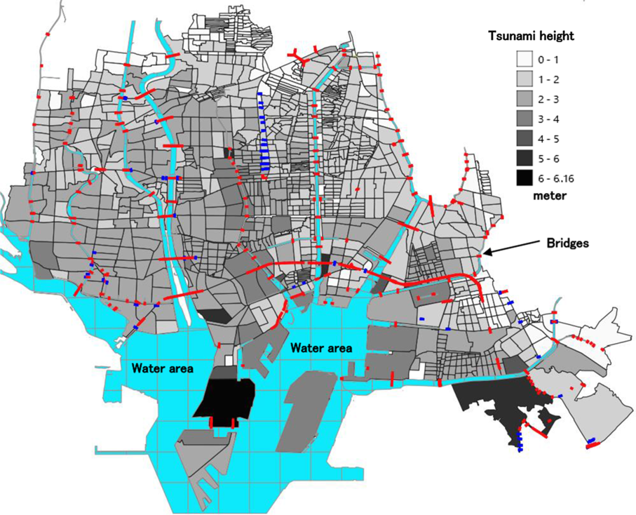
FIGURE 1 Prediction of Tsunami Invasion in the Nagoya City Coastal Area.
APPLICATION OF ESTIMATED DATA BY MACHINE LEARNING
Hattori and HattoriReference Hattori and Hattori5 developed a machine learning model to estimate the number of pregnant women in small community areas from 1737 record of nation-wide data. The estimation acquired by this model was applied to small areas of tsunami-predicted areas in Nagoya City, Aichi Prefecture. In this study, 40 (wks) /52(wks) were multiplied by population data because the original data were annual statistics. Figure 2 shows the estimated number of pregnant women in tsunami-predicted areas.

FIGURE 2 Estimated Number of Pregnant Women in Small Community Areas in the Coastal Ward of Nagoya City.
ESCAPABLE AREA FROM A TSUNAMI
Disaster evacuation on foot has been recommended before now, but the use of automobile for evacuation became acceptable after the Tohoku Earthquake Tsunami Disaster of 2011.6 There were cases where people escaped by automobile from an approaching tsunami. The speed of the automobile was advantageous.
GEOGRAPHICAL DEVELOPMENT OF THE CITY
The City of Nagoya has a vulnerability against a tsunami. The city was built by irrigation and landfills over an alluvial plain produced by several rivers coming from major mountain areas of Honshu Island. Coastal area wards had been farmlands but were changed to residential or industrial areas with urban sprawl. Sections are separated by rivers and canals, and they are connected by bridges. The bridges will be bottlenecks for evacuating traffic.
EVACUATION ON FOOT
Disadvantages of the use of automobile have been indicated. Traffic signals become dysfunctional by blackout or damages of signal systems. There is a possibility that so-called gridlock phenomena appear at multiple points of devastated areas simultaneously. Even in Tokyo, there were gridlocks after a Tohoku earthquake and a tsunami disaster.Reference Kiyota, Iwakura and Nonaka7 Emerging traffic moving toward the same direction generated jams at many intersections. There were many cases where a whole train of evacuating cars were caught by gridlock and swept away by a tsunami.8 Evacuation on foot, which is reliable in many situations, is assumed as a countermeasure for escaping a tsunami disaster.
Walking Speed and Walkable Distance of Pregnant Women
Pregnant women were presumed to be able to walk 30 meters per minute and continue to walk for 60 minutes. A 1-hour walk, total of 1800 meters (1.1 miles), was regarded as the longest evacuation distance. Road centerline data of Nagoya City Second Medical AreaReference Hattori and Hattori5 were introduced. From the terminal edge of the tsunami, 1800-meter road distances were measured by network analysis of QGIS.9 Areas presented using fine lines in Figure 3 are those escapable from the tsunami by evacuation on foot.

FIGURE 3 Area of 1800 Meters From the Terminal Edge of the Tsunami.
NUMBER OF PREGNANT WOMEN IN THE TSUNAMI-PREDICTED AREA
Areas were divided by administrative areas and possible evacuation routes. Evacuees were assumed to transport toward the north direction or toward areas with a higher altitude on the east side. Area borders are presented by thick lines, and a summary of evacuating pregnant women in each area is presented in Figure 4. An estimated total number of full-term pregnant women of 37 to 40 weeks is 261. Facilities for these women should be prepared. There are a total of 591 pregnant women of 28 to 36 weeks, when risk of early delivery increases. Estimated numbers of full-term pregnant women and those of high risk women are presented of each evacuation direction by a boxed number and underlined number, respectively, in Figure 4.

FIGURE 4 Summary of Estimated Number of Pregnant Women in 1800 Meters Distant From Safe Area, Total Number of Pregnant Women to Each Evacuation Direction, That of Full-Term Women, and That of High Risk Women.
SAFE AREA PASSED OVER
Through this GIS analysis, a safe area passed over became clear. There is a cargo container base (Arrow in Figure 5) in the middle of the tsunami-predicted area. The lowest altitude of the area is 5.4 meters, and the highest tsunami height of neighboring areas is 2.33 meters. The area is 35 hectares (0.135 mile2) wide. There are assumed problems such as operation of traveling trains, containers which may tip over by earthquake, strength of slope face of this high area, route to climb up to the high points, installation of gate, and so on. This area is expected to receive 625 pregnant women. The feasibility study on the use of the cargo container base for disaster evacuation and authorization based on the feasibility study are expected.

FIGURE 5 Added Number of Pregnant Women Who Can Evacuate If the Cargo Container Base is Open for Evacuation.
FACILITIES SUPPORTING PREGNANT WOMEN
There are medical facilities and individuals that will mobilize their functions to support pregnant women. They include the disaster base hospital (DBH), perinatal medical center, area health care center, obstetricians and gynecologists, and midwives. See Figure 6.

FIGURE 6 Facilities Able to Support Pregnant Women in Nagoya City After a Tsunami Invasion.
Disaster Base Hospitals
DBHs are hospitals that are able to provide emergency medical activities and to receive injured and sick patients. The hospitals have access to helicopter transports. Emergency medical teams, which are able to work with firefighter emergency teams or other rescue workers, must be organized. The hospitals must satisfy earthquake-resilient building standards and must have substitute electric power, water supplies, and ambulance cars. The hospitals must also have functions to dispatch their emergency medical teams to devastated areas. There are 11 DBHs in Nagoya City.10
Perinatal Medical Centers
Perinatal medical centers are established to support local obstetricians and gynecologists. The comprehensive perinatal medical center (CPMC) must install a neonatal care unit (NICU), growing care unit (GCU), and maternal-fetal intensive care unit (MFICU), and the CPMC must be able to carry out around-the-clock medical treatments for high-risk pregnant women, intensive care for preborn children pared, and newborn intensive care. The CPMC is expected to coordinate areal perinatal medical care network as a pivot. The areal perinatal medical center (APMC) has obstetrics and pediatric departments, and has a function to accept emergency transportation of patients from local obstetrics clinics and birth centers.11 There are 4 CPMCs and 3 APMCs in the city. Perinatal emergency medical centers (PEMCs) are installed at 7 hospitals, in addition to the CPMCs and APMCs.12
Area Health Care Centers
The area health care centers (AHCs) are core of medical administrations such as total health care planning, awareness programs for mother and children, and appraisal of local medical facilities. Pregnant women receive health care services and guidance legally designated to provide. The centers are expected to function as a core of health care services under a disaster. There are 23 AHCs.13
Obstetricians and Gynecologists, Midwives
There are 93 hospitals and clinics at which birthing equipment is installed14; 38 midwives are in private practices in the city. Further survey is needed about the functions of the obstetricians and gynecologists when disaster occurs. Traditionally, medical doctors tended to practice at their residences, but, recently, they commute to their offices in large cities from their residences.
FACILITIES IN TSUNAMI-PREDICTED AREAS
Three DBHs, 1 APMC, 2 PEMCs, and 11 facilities are located in tsunami-predicted areas (Figure 6). They may reduce their functions after an earthquake and cease the functions after a tsunami. It is rational to develop a plan to support pregnant women without these facilities.
EVACUATION FACILITIES
The best efforts must be made for the evacuation of pregnant women from tsunami-predicted areas. However, there are pregnant women who may not be able to evacuate from the predicted area. The women must be protected from invading tsunami water with a large amount of debris and heavy mud raised from the sea bed.
USE OF TSUNAMI EVACUATION BUILDINGS
There are areas that are too far from a high point to escape from a tsunami invasion. In order to increase the survival of residents, tsunami evacuation buildings, which are steel-reinforced concrete buildings and satisfy Quake-Resistance Standards of 2000, developed after Hanshin-Awaji Earthquake of 1995, have been promoted.Reference Office15 Prefectural and local governments are carrying out survey and designating buildings. In coastal area prefectures, specially designed tsunami evacuation towers have been built. City of Nagoya contracted building owners and designated tsunami evacuation buildings in areas where evacuations are difficult.16
DISPUTABLE QUESTION OF EVACUATION BUILDINGS
Although tsunami evacuation buildings have been designated, there are disputable questions. Two different kinds of tsunami height must be considered. Although regular tsunami height was used in this simulation, tsunami runup height must be considered. A tsunami increases its height when it runs up a long floor of sea slope, such as sea with shoals. It also increases its height when it comes into a convergent shaped bay. The energy of a tsunami is concentrated, and the height of a tsunami increases toward the closed section of the bay.
Tsunami Runup Height
Research on tsunami runup height is not yet sufficient, but it is known on an empirical basis that tsunami runup height is the same or 4 times the height of tsunami height. A recorded tsunami height in the 2011 disaster exceeded 15 m at Fukushima and Iwate prefectures.Reference Nyoumura17 The vestigial heights of tsunami runups were 40.5 m (134 ft), 32.4 m (107 ft), and 31.9 m (105 ft) at Miyako City, Kamaishi City, and Ofunato City, respectively.Reference Nyoumura17
STRENGTH OF EVACUATION BUILDINGS
Wooden residential buildings begin to break by a 1-m high tsunami. The buildings will be destroyed in full scale by a 2-m. high tsunami. Reinforced concrete buildings may not tolerate the tsunami if the tsunami height surpasses 5 m.18 Even a concrete building will be destroyed totally by a tsunami higher than 16 m.
In the case of the 2011 disaster, a GPS wave gauge installed offshore recorded a 6-m high tsunami multiple times. This means that a tsunami as high as 12 to 18 m invaded the coasts. Out of the tsunami heights in the coasts, it is estimated that there were about 40-m high tsunami runups.Reference Nyoumura17 The predicted tsunami height at Minato ward, located at the coast, will be 3 m (City of Nagoya, 2018). It is not incredible to estimate a 12-m high tsunami runup at the coastal area of Nagoya City.
It is not certain whether all of the evacuation buildings can tolerate the tsunami runup. At this moment of time, it is recommended to visit tsunami evacuation buildings near residences and make a judgment about the best selection. The Individual Evacuation Plan (IEP) is important, and efforts for self-help are significant.
PREGNANT WOMEN IN DIFFICULT-TO-ESCAPE AREAS
Approximately 1200 pregnant women will be left in areas where evacuation on foot from a tsunami is difficult. An available method to support them is to provide tsunami evacuation buildings for initial protection (Figure 7). The small dots in the figure represent tsunami evacuation buildings. After a tsunami recedes and aftershocks stop, the women should be transported to safer facilities or appropriate accommodations.

FIGURE 7 Estimated Number of Pregnant Women Living in Areas Where Evacuation From a Tsunami is Difficult on Foot and Tsunami Evacuation Buildings.
SUMMARY AND CONCLUSION
From this simulation, next research activity targets were revealed.
-
1. Planning of triage points in areas to which pregnant women are evacuating. The women will be transferred to facilities – CPMC, APMC – or to the care of obstetricians and gynecologists or to appropriate accommodations.
-
2. Training of staff, who engage in perinatal care rescue operation, to interpret information transmitted from disaster recon groups. (Recon groups equipped with helicopters and drones are being organized. Self Defense Force, police force, Geospatial Information Authority of Japan, and others are participating in the recon activities.)
-
3. GIS trainings for perinatal care rescue operation teams.
-
4. Development of an Individualized Evacuation Plan (IEP) for pregnant women and promotion of grassroot activity for self-help and mutual help.
-
5. Development of smartphone application for pregnant women. A large number of pregnant women will be left in tsunami-invaded areas. It is not possible to rescue all of the women simultaneously, and priority must be given to women who need urgent needs, such as delivery or a high risk of miscarriage. Information on these women are important to prepare a rescue plan and to determine rescue priority. If the women’s clinical conditions are properly conveyed to the perinatal rescue workers, the appropriate treatment will be provided.
Conflict of Interest Statement
The authors have no conflicts of interest to declare.


