

Introduction
In the twenty-first century, if someone asks for my address I give a house number, a street name, a suburb, the name of my state, and a postcode. And because I live in a rather out-of-the-way spot where the postman doesn’t visit I also give a post-office box number in case the said person wants to send me mail. Neither the language I use to express this information nor the taxonomy by which it is organized is mine. Each is the invention of a government bureaucracy. Although this formula is almost universally comprehensible—anyone on the planet can use it to locate me with utter precision—it says nothing whatsoever about who I am, what the place where I live is like, or my relationship with that place.
If one were able to ask a fifteenth-century Florentine for an address, they would not reflexively regurgitate the number, street name, suburb, state, and postcode formula. Instead one would hear an answer like: “I live in the parish of Santa Trinita”; “behind the Servites”; or “at the corner of the Millstone.” Or perhaps, “I live in the street that leads to the Piazza Vecchia and comes from the Piazza di Madonna.” A product of the kind of society in which everyone went where they needed to go on foot, talk such as this reflects what may be termed a prepositional relationship with the urban environment, whereby Florentines instinctively positioned themselves in relation to places that they knew firsthand and the people who filled them. They lived behind, in front of, opposite, over, and near neighbors; by churches, palaces, and shops; at corners and in piazzas or streets that came from place X and went to place Y.Footnote 1 One of the first things that Antonio Manetti did in his life of Filippo Brunelleschi was enumerate the houses owned by the Brunelleschi family. In doing so, however, Manetti did not simply recite a list of addresses: he plotted a network of spatial coordinates by which readers could temporally and physically locate his subject’s family on their mental map of the city: “The family to which Filippo belonged has presently, and had during his lifetime, houses in various parts of the city: opposite the Oratorio of Orto San Michele; near San Bartolomeo on Corso degli Adimari; near the Canto de’ Ricci; near San Marco, toward the end of Via Larga on the lefthand side coming from San Giovanni… . Filippo, whom we are discussing, lived and died in a house located obliquely opposite San Michele Berteldi in a cul-de-sac beyond the Piazza degli Agli, on the right side as one goes from the east toward the west.”Footnote 2
Although such data may seem mundane, they belong to the reality distilled so memorably in Italo Calvino’s 1972 novel Invisible Cities. The story contains a famous passage in which Marco Polo laments the difficulty of communicating to the emperor Kublai Khan a faithful account of what he has seen on his travels. Invoking Zaira, “city of high bastions,” Marco explains that he could easily supply the great Khan with raw facts about the place, such as “how many steps make up the streets rising like stairways, and the degree of the arcades’ curves, and what kind of zinc scales cover the roofs.” As Marco goes on to say, however: “I already know this would be the same as telling you nothing. The city does not consist of this, but of relationships between the measurements of its space and the events of its past: the height of a lamppost and the distance from the ground of a hanged usurper’s swaying feet; the line strung from the lamppost to the railing opposite and the festoons that decorate the course of the queen’s nuptial procession; the height of that railing and the leap of the adulterer who climbed over it at dawn; the tilt of a guttering and a cat’s progress along it as he slips into the same window.”Footnote 3 Calvino’s point was that, more than a physical fact, the city is a congeries of overlapping places whose significance is inseparable from the things that have happened in them, the ways they are used by their inhabitants, and the meanings that have attached themselves with the passing of time.
Many years before Calvino wrote his novel, Mikhail Bakhtin appropriated the concept of the chronotope from mathematics to express a similar idea. Bakhtin’s literary chronotope—literally “time” plus “space”—expresses in metaphorical terms the culturally thickening effect of temporal events, the process by which “space becomes charged and responds to the movements of time, plot and history.”Footnote 4 In Bakhtinian terms, every Florentine alley, street corner, and thoroughfare, every palace, monument, bridge, and piazza is a chronotope: a place produced by the intersection of history and physical space. Bakhtin’s metaphor is not some recondite amusement—it expresses very well the Florentine proclivity for using local language to describe urban reality, and for incorporating local history as functional nomenclature. It is probably a sign of the cultural distance that separates the twenty-first century from premodern Florence that one would not expect today to find evidence of the phenomena that Calvino, Manetti, and Bakhtin addressed in a tax return. In the fifteenth century, however, the elusive spaces that these writers conjure crop up repeatedly as one element of a bureaucratic formula in the controversial tax census known as the Catasto.
The Catasto and the Confini
Introduced by the Florentine government in 1427, the Catasto required every householder to submit a portata (notarized declaration) listing taxable assets, liabilities, and deductions. After the net value of the household was determined, the actual amount of tax to be paid by each declarant was calculated by means of a mathematical formula. In compiling the portata, the householder began by recording his or her name and, frequently (though not always), an occupation. Next came a list of the householder’s urban properties, followed by rural holdings, the value of business dealings, debts, credits, financial obligations, and liabilities. Last to appear was a list of bocche (mouths)—that is, dependent household members—given that each dependent entitled the declarant to a tax deduction on the sum for which he or she was liable.Footnote 5
As indicated, urban property ownership was usually the first category to appear in a portata after the name or occupation. When there were two or more urban properties to declare, these were usually presented as a list, with the family’s primary residence appearing first.Footnote 6 Each property was then defined by several subcategories of information. A typical example is the return submitted in 1427 by Vieri di Francesco del Bene. After supplying his name, Vieri identified his primary residence, displaying the prepositional consciousness described above by locating his house in relation to its borders or confini (confines), the buildings and spaces by which the house was surrounded. In doing so, Vieri turned his home into a chronotope: “A house in which he lives [chasa per suo abitare] located in the parish of Santo Apostolo, [bordered by] on the first and second side, the alley; third, Antonio di Messer Ricciardo; fourth, the heirs of Antonio di Pippo da Montebuoni and other [confini]; with household effects [maserizie] for the use of the said house.”Footnote 7 Nothing could seem less remarkable than this, until one considers that in ontological terms almost none of the data supplied were objective or given facts. Nearly every piece of information in the quoted passage was generated within the larger context of an official survey that was not merely a revenue-raising exercise but was also a political tool by which the commune mapped and ordered a complex urban reality in order to govern it.Footnote 8
In this article I pay close attention to the form and language of the confini, which until now have attracted no systematic analysis.Footnote 9 My reason for doing so is that the confini expose, at an extremely high level of magnification and from an unusual angle, social processes and spatial relationships responsible for producing the semiotically charged places that Calvino instinctively understood, and which Bakhtin theorized. In contrast to the ritualized behaviors and extraordinary events that often attract the attention of scholars because they excited comment among contemporaries,Footnote 10 the distinguishing feature of the confini is their utter banality. Because they reflect patterns of thought so deeply embedded that they provoked little if any conscious reflection, they merit consideration in the context of the so-called spatial turn, which has had such a profound influence on the recent historiography of the early modern city.Footnote 11 This movement, which traces its beginnings to the 1970s and 1980s, owes a particular debt to the revisionist work of French philosopher and sociologist Henri Lefebvre, as enunciated in his monumental work, The Production of Space.Footnote 12 One of the author’s principal concerns was to reject an earlier scholarly tendency to conceive of urban space in purely geometric terms, as a “passive receptacle” for social behavior.Footnote 13
Lefebvre proposed a tripartite schema in which space appeared instead as a dynamic quantity, constantly produced and renewed by a “multitude of intersections, each with its assigned location.”Footnote 14 In Lefebvre’s analysis, these intersections fall under three distinct but overlapping rubrics: (1) “spatial practice”: space as “perceived” in the citizenry’s negotiation of the patterns, rhythms, and activities that constitute everyday life; (2) “representations of space”: normative and ideological concepts by which space is “conceived” by the dominant intellectuals and technocrats in any society; (3) “representational spaces”: space as “lived” through the medium of a society’s “associated culture and symbols.”Footnote 15 Lefebvre insisted urgently on the fact that this schema was not a binary but a triad. He contended that the apparent rationality of the former promotes a species of either/or reasoning that too easily abstracts itself from reality. By contrast, the “perceived-conceived-lived triad … loses all force if it is treated as an abstract model.”Footnote 16 That fact, he argued, is its strength, for while the triad might not always amount to a coherent whole, it encourages consideration from three different conceptual vantage points of citizens’ collectively lived experience of urban space.Footnote 17 While my present objective is not to accommodate the Catasto to Lefebvre’s analysis, his layered way of thinking offers a useful heuristic approach to analysis of the confini.
The confini, in turn, offer an unusual opportunity to exploit highly focused analysis of a single element in a specific Florentine source to reflect on themes and issues currently of wider interest to historians of late medieval and early modern European urban space. Recently, scholars have traversed disciplinary boundaries by blending text and image, as well as by leavening study of architectural and intellectual history with political, economic, social, and cultural-historical sources. In the process, they have shed new light on subjects including the politics of urban space; the symbolic and practical significance of features such as city gates, walls, and towers; and anthropomorphic metaphors that figured the early modern house as a living entity.Footnote 18 Especially noteworthy are studies that address the complicated relationship between everyday life as it was actually lived in the city and as represented in a range of more and less idealizing contemporary maps and images.Footnote 19 This latter group includes large-scale online digital mapping projects such as the University of Toronto’s study of the Florentine decima tax of 1561 (Digitally Encoded Census Information and Mapping Archive [DECIMA]), which presents geo-coded data from three Florentine censuses (1551, 1561, and 1632) in an online version of the hand-drawn map of the city created by Stefano Buonsignori (d. 1589); the University of Victoria’s The Map of Early Modern London (MoEML), which presents the Agas woodcut map of London from 1561 as a graphic interface, complemented by an encyclopedia, descriptive gazetteer, and library; and Locating London’s Past, which relates a GIS compliant version of John Rocque’s map of London (1746) to the first historically accurate ordinance survey map of London (1869–80).Footnote 20 Still another group of pioneering scholars has in a quasi-literal sense broken the silence of the past by listening in to the distant world of the early modern European city. Confronting and challenging the Western academic tradition’s fixation on text and image, these protagonists of the “acoustic turn” have brought sound from the margins to the center of attention, establishing it as a dynamic and formative component of physical and historical space, every bit as important as sight, touch, and smell.Footnote 21
Study of the confini in the Catasto does not merely append the Florentine example to this wider discussion of European themes: it also creates different angles of vision that allow genuinely new insights to emerge. In the first place, it does this by facilitating unusually detailed analysis of the elusive mingling of everyday social activity and the physical setting in which it was enacted. Second, the potential for the fragmentary data of the confini to be blended with a range of other sources—social, political, economic, visual, and literary—provides the wherewithal to reconstruct a literally multifocal view of social experience. In other words, the confini represent an opportunity to ground Lefebvre’s theorization of space as a social production in the there and then of the fifteenth- and early sixteenth-century city. It is in this context that I hope the following discussion will be of use to students of early modern European urban culture in cities outside Florence and Italy.
Micro-neighborhood and Urban Identity
One obvious effect of the Catasto’s taxonomy was to map Florence as the sum of its tax-assessable households. Together, Vieri del Bene, his dependent wife, children, and the house in which they lived constituted the basic unit of a system of classification that self-evidently expressed and reinforced the values of the Florentine communal government. In this frame of reference, terms such as chasa per suo abitare (a house in which he lives), parish of Santo Apostolo, alley, the implicitly understood bordered by, maserizie (household effects), even use, cannot be treated as neutral. Here it must be emphasized that to characterize the Catasto as a Procrustean template imposed on a passive populace by an authoritarian government would be an exaggeration and an oversimplification. To be sure, the Catasto was framed in normative terms that are assimilable to Lefebvre’s “representations of space” (the second category in his triad). However, unlike the objectionable managerialese of so much twenty-first-century bureaucracy, the Catasto’s terminology was not alien to the citizens whom it regulated and classified. On the contrary, the Catasto spoke the language of everyday urban experience and family life—what is more, it allowed householders to do the same.
This last point emerges in the confini, which, for all that they formed part of a highly bureaucratic government census, preserve traces of the evanescent discursive process by which citizens evoked and reproduced the smallest of urban spaces in the pursuit of their everyday lives. Hence the richly evocative detail of the confini submitted by Filippo Bombeni in the Catasto census of 1457. Filippo declared that “I live in the palace [palagio] of the Bombeni, which came to me by testamentary bequest of my ancestors, and which I maintain purely for my habitation and it is mine.”Footnote 22 Describing a second house with a workshop that he let to tenants, and an additional property (terreno) that he rented himself from the Vallombrosan abbot of Santa Trinita, Filippo sketched the vivid thumbnail portrait of a concentrated little world whose unity resided in the concrete spatial relations of its individual elements. Lying “opposite [the church of] Santa Trinita,” all three properties were physically connected to each other. Filippo clarified that the first workshop, rented by a carpenter named Andrea, was located “under [sotto] the palace of the Bombeni” in which he lived himself. The second house at rent, occupied by a wool-comber named Lorenzo, was also “attached to the said palace.” Of the terreno, formerly a carpenter’s workshop, Filippo wrote that it was located “under the said palace, and it is next to the arch which is opposite the Tornaquinci [family], and it is above this terreno, that is, workshop, that I live.”Footnote 23 The more portate one reads, the more aware one becomes of a discursive feedback loop by which the Catasto utilized the everyday language of citizens to parse the city’s urban geography and then refract it through a governmental lens.
One of the noteworthy aspects of portate such as these is their emphasis on surrounding individuals and properties. Reports submitted by citizens like Vieri del Bene, Filippo Bombeni, and the thousands of others that fill the bound volumes of the Catasto in the State Archive of Florence testify to the way contemporaries intuitively defined and emplaced themselves in physical relation to the people who lived and worked next to, over, under, and near them.Footnote 24 The Catasto’s requirement that householders furnish numbered lists of their confini codified this impulse; at the same time it allowed citizens to speak in their own language, and in personal terms, about intimate connections with the urban environment that are often elided by the kind of official structures that have more usually attracted the attention of social historians: parish, gonfalone (neighborhood division),Footnote 25 quarter, sesto (sixth).
It may perhaps be objected that the confini were just one of many boxes to be ticked in a compulsory bureaucratic survey, not diary entries in which citizens confided their innermost thoughts. My response to this reservation would be that the habit of identifying urban property by its relation to surrounding buildings, people, features, and spaces is sufficiently alien to us that, like a Parisian cat massacre or a Balinese cockfight, it calls for explanation.Footnote 26 And the richest context for such an explanation is, precisely, the neighborhood culture about which, thanks to nearly half a century of scholarship, historians now know so much. What this literature tells us is that explaining the form of the confini with reference to the culture of neighborhood involves no category error. One of many possible supporting examples is the colorful satirical tale of The Fat Woodcarver, which has attracted much scholarly attention in the last few years.Footnote 27 Written down around 1480 by Antonio Manetti, the novella purportedly tells the true story of a group of talented friends, led by none other than Filippo Brunelleschi, who performed a cruel psychological hoax on a less-than-brilliant companion nicknamed Grasso, the tale’s eponymous woodworker. By a series of ingenious pranks and cons, Filippo’s brigata, his gang, so unbalanced Grasso’s sense of himself that he literally ceased to know who he was. What counts in the present context is the strategy underlying the deception: Grasso’s friends systematically alienated him from his habitual surroundings and associations by pretending to mistake him for another person. Filippo’s masterstroke was to burgle and occupy Grasso’s house while he was out. When Grasso arrived home and found his own door locked against him, Filippo spoke from inside, pretending to be him. Grasso was so disoriented by this and the other ruses perpetrated against him that he believed that he had become someone else.
Manetti’s story has an obvious subtext: cast out of the networks of your friends and acquaintances, deprived of your home, you cease to be. Conversely, it is in regaining these things that Grasso rediscovers his lost self. Hoodwinked, drugged, abducted, and dumped at home on his bed by his best friends in the world, he spent the entire night in a coma. Next morning, however, “awakening to the sound of the Angelus from Santa Maria del Fiore [the cathedral], when the effects of the potion had worn off and it was already daylight, he recognized the sound of the bell and, opening his eyes, saw some chinks of light in the room and realized that he was in his own house, and his heart was suddenly filled with great joy, for it seemed that he had become Grasso again and was master of all his possessions.”Footnote 28 Or to put it in the terms of the Catasto, Grasso is nothing—worse, he’s someone else—without his confini.Footnote 29 Central to this scene is the point emphasized in their different ways by Calvino and Lefebvre: that the city comprehended as the arithmetical sum of its measurable spaces is no city at all, that space only has historical meaning when understood in relation to “the events of its past.” Placed in the same setting, no stranger would have felt as Grasso did: his joy is produced by the realization that he has been repatriated amid an ensemble of familiar households, sights, sounds, objects, and neighborhood spaces that by long and intimate association have come to define him as a person.
As already suggested, spaces such as these are arguably the most difficult for the historian to analyze. They are hard to document because, intrinsic as they were to the ceaseless rhythms of everyday life, contemporaries tended not to comment directly on them. In addition, their elusiveness and complexity are easily lost if they are filtered through a priori formal categories. Binaries that figure the city as “planned” or “unplanned,” or which characterize space either as “private” or “public,” can reify false dichotomies that will not capture the fluid structures and experiences that Manetti describes.Footnote 30 In recent work, as Riitta Laitinen and Thomas V. Cohen have observed, some scholars have even suggested that in the premodern European urban setting there was no such thing as a defined “public” or “private” space in our terms.Footnote 31 Others, such as Daniel Jütte, have in a rather different sense cautioned against a romanticism that encourages historians to naturalize the early modern past as an age without privacy, when “doors [were] only seldom locked” and people presumably walked in and out of each other’s properties at will.Footnote 32 If Grasso’s tale tells us anything, it is surely that in certain contexts early modern urbanites had a highly developed sense of what one can only call private space. What is clear at least is that while historians are yet to come fully to grips with how notions of privacy worked in the premodern European city, privacy and publicness are not and have never been intrinsic properties of physical space; rather, they are contingent expressions of the power relationships that prevail in that space. As such, they can be identified and described in every urban setting.Footnote 33
Scholarship published under the rubric of the spatial turn tells us that the spaces of people’s everyday urban experience in medieval and early modern Europe were often porous in the literal sense, and that the mental categories by which citizens accommodated themselves to such irregular environments were correspondingly permeable. Emese Bálint’s analysis of the “hue and cry” in late sixteenth-century Kolozsvár explains how, for instance, in a town prone to public violence, shouting out the word Tolvaj (thief) in public summoned a “spontaneous” public to assist the victim of a crime while simultaneously triggering a legal process to prosecute the accused malefactor. Where the victim was a cuckolded husband and the accused an allegedly unfaithful wife, a conjugal dispute could be drawn out of the private home into the street, dissolving the barrier between domestic and public space and turning marital friction into a community event.Footnote 34 Speaking of late seventeenth-century Paris, David Garrioch has made it clear that in such cheek-by-jowl environments, “thin walls and narrow streets” allowed people to glean potentially embarrassing levels of knowledge about their neighbors’ intramural habits even when there was no legal crisis.Footnote 35 Building materials played a major role in this context: one side effect of replacing timber with brick as a building material in the wake of the Great Fire of London was to reduce such unwelcome intimacy.Footnote 36
Vanessa Harding’s fascinating study of the medieval London property market raises complementary themes that resonate with my own inquiry into the confini in the Florentine Catasto. In London between the twelfth and fourteenth centuries, she reveals, buyers of urban properties frequently acquired—along with the property that they purchased—liability for a host of financial obligations and regular payments to previous owners or stakeholders that might go back over many decades. Ownership of private property was a less autonomous experience than it is today, and, as Harding also shows, the matter of where one property ended and another began became more and more contested as plots were subdivided, re-sold, and modified over generations. The increasing physical complexity of these houses, and the customs and legal conventions governing what was socially acceptable, rendered the relationship between private property and public space an exceedingly complicated question.Footnote 37 Arguably there is no more sensitive example of the tensions that could erupt on the uncertain divide between public and private realms than that concerning the status of the doors and windows of Jewish houses in Europe’s overwhelmingly Christian early modern cities. Predictably, perhaps, such liminal zones were the object of frequent anti-Semitic violence, but as Daniel Jütte has powerfully argued, the situation could be less clear-cut than scholars have assumed. Not all of the violence at Jewish portals was enacted by Christians. One exception Jütte cites concerns social inequality within Jewish communities themselves, especially where Jewish people were forced to compete for resources in the overcrowded ghettos where many were forced to live. Internal strife fostered by such inequality and lack of room could on occasion play itself out at these same sites.Footnote 38
In a Europe-wide context, the confini offer an unexpected opportunity to engage with the historically contingent ways that Florentines constructed and represented the spaces that were closest to home. The example of Lionardo de’ Nobili, wealthy son of a knight, demonstrates how the confini begin to sketch the spatial coordinates of this microcosmic sensibility. Lionardo de’ Nobili owned two substantial residences in the heart of old aristocratic Florence, to each of which he devoted a separate entry in his Catasto report in 1427. These houses stood next to each other between the old church of San BiagioFootnote 39 and Via Por Santa Maria on the eastern side of the piazza where the palace of the conservative Parte Guelfa (Guelf Party) was located. The more northerly house was Lionardo’s residence, where he lived as the head of a large, extended ménage (see item 5a in fig. 1).Footnote 40 The first part of the entry in which Lionardo described this house reads as follows: “A house [una chasa] where we live, located in the parish of Santa Maria Sopra Porta on the piazza of the Parte Guelfa, with five workshops under the said house. On the first [side]: street. On the second: the said piazza. Third: street. Fourth: the guild of the bankers and money-changers and other true confini.”Footnote 41 Lionardo’s description strongly suggests that his residence faced west onto the piazza of the Parte Guelfa. Certainly, the building stood at the northeastern corner where the piazza met the Via Porta Rossa, because both the piazza and property owned by the Arte del Cambio (Guild of Moneychangers) appear as confini. The fourth confine suggests that part of the house was located opposite the headquarters of that guild, which stood directly across the street on the north side of the Via Porta Rossa. Also on the north side of Via Porta Rossa, in an area honeycombed by narrow laneways and tiny piazze, was a further cluster of properties belonging to kinsmen of the de’ Nobili lineage.Footnote 42

Figure 1. The houses of Lionardo de’ Nobili in central Florence, superimposed on Stefano Buonsignori’s map of Florence, 1584 (detail). Courtesy of the Harvard Map Collection. 1. Via Porta Rossa. 2. Piazza of the Parte Guelfa. 3. Mercato Nuovo. 4. Church of San Biagio (formerly Santa Maria Sopra Porta). 5a–b. Properties declared by Lionardo de’ Nobili in Catasto of 1427. 6. Location of headquarters of the Arte del Cambio.
Abutting Lionardo’s house on the southern side was the second chasa, occupied by a well-to-do tenant named Maestro Ridolfo da Cortona, who paid him the considerable rent of one hundred florins a year.Footnote 43 Notwithstanding the apparent gap shown on the later Buonsignori map, these two houses should not be conceived of as separate entities. Close analysis of the other urban properties named in Lionardo’s report makes apparent that they constituted the western end of a cluster of properties, all of which he owned, and which extended eastwards from the piazza of the Parte Guelfa toward the Mercato Nuovo. Lionardo declared these easterly properties in a third separate entry as “Two houses and a broken-down tower [toraccia] on the piazza of merchato nuovo.”Footnote 44 In 1427, the toraccia and the four houses huddled around it comprised much of the urban block bordered by the piazza of the Parte Guelfa, Via Porta Rossa, the northern end of the Mercato Nuovo, and, on the southern side, the chiassi (alleys) that Lionardo nominated as the second and third confini of the house occupied by Maestro Ridolfo.Footnote 45
As terse as they are, Lionardo’s descriptions have something to say about the relationship of these buildings to the capillary networks of streets that ran between and around them. The absence of a rigid divide between public and private realms in this porous urban environment means that the de’ Nobili’s complex could in no way have stood apart from its immediate environs. On the contrary, the multifarious uses to which Lionardo’s properties had been adapted guaranteed that the rising and falling commercial tides that nourished the square of the Mercato Nuovo would have flowed in and out of their entrances and exits every day. On the side facing the market square only two of Lionardo’s properties were family residences in 1427. One was inhabited by the household of his kinsman, Benedetto de’ Nobili, who rented “part of the said houses.”Footnote 46 The second was home to the less socially elevated family of Giovanni di Antonio Doni, who paid an annual rent of ten florins.Footnote 47 The remaining properties facing the piazza of the Mercato Nuovo were subdivided into business premises and let to a number of tenants who included citizens from among the city’s most eminent families. Vanni di Niccolò di ser Vanni paid a relatively high annual rent of thirty-five florins for one of the banking premises, or banchi, into which the ground floor was divided.Footnote 48 Luca Rinieri rented a second banco for thirty florins, while Nicola and Cambio, the sons of Vieri de’ Medici, rented a third for the same amount. At the northeastern corner, in a prime position where one could presumably have kept an eye on what was happening in the market while also looking up and down Via Porta Rossa, Lorenzo di Messer Palla Strozzi, a son of Florence’s wealthiest citizen in 1427, rented yet another of the banchi. As the center of Florentine banking and trade, the Mercato Nuovo was full of such shop fronts, as they might now be called. They occupied the ground floors of many of the buildings that surrounded the piazza, opening on to the street while at the same time offering more private internal spaces where clients could conduct their business with the necessary discretion.Footnote 49 Neither totally public nor entirely secluded, shops such as these had, like other kinds of commercial premises, served since ancient times as places where people, usually male, could meet informally to exchange news, gossip, and pass the time.Footnote 50
A Lynchean Reading of Florentine Micro-neighborhoods
While in literal terms the confini simply indicated a property’s physical proximity to other buildings, spaces, and people, the spatial relationships between these elements were vital components of personal identity, as the example of Grasso the woodworker underscores. In drawing out this dimension of the confini one may usefully invoke the concepts of “imageability” and “legibility” theorized by town planner Kevin Lynch to explain how people generate “mental maps” as a means to “read,” interpret, and negotiate the urban environment. Among the several elements of which such maps are constructed in Lynch’s analysis is the “district,” a relatively large area that citizens or visitors are aware of entering, occupying, or leaving because it is distinguished by a common character.Footnote 51 In reconstituting the evidence of the confini, hints emerge that, like the Vrijdagmarkt (Friday Market) in medieval Ghent or the area of the Venetian Rialto Bridge, the Mercato Nuovo may be described in Lynchean terms as a district—that is to say that contemporary Florentines would have perceived the area as a distinct entity within the larger city.Footnote 52 That they did indeed do so emerges in Catasto reports where it can be demonstrated that use of the name Mercato Nuovo was not restricted rigidly or literally to the market square itself. In these reports, citizens used the name to refer to the market and its environs as a loosely contained zone that merged seamlessly with surrounding neighborhoods. The market in any late medieval European town was a site specifically and officially allocated to commercial activity,Footnote 53 but it was also a place where, à la the Venetian lodgings that Anton Francesco Doni satirized in a private letter, residents could be aware of their immersion in a sensorium of activities, sounds, and smells that respected no impermeable barrier—physical, mental, or sonic—between public and private.Footnote 54
Altobianco Giandonati, one of Lionardo de’ Nobili’s neighbors, declared in 1427 that he lived in a house “in merchato nuovo in the parish of Santa Maria Sopra Porta.”Footnote 55 Agnolo degli Oriuoli did the same, asserting that he lived with his family in a rented house in Via Porta Santa Maria, “in merchato nuovo.”Footnote 56 Dino di Antonio Canacci explained that he had recently sold a goldsmith’s workshop, formerly a banco—once again, the location supplied was “in merchato nuovo.”Footnote 57 In each case, by dispensing with the definite article, the declarant transformed the literal descriptor of an actual marketplace into a metonymic signifier of an urban locale with a distinctive character. Cantino Cavalcanti used this formula with reference to his majority share of a large house, complete with ground-floor workshop, “in merchato nuovo” at the northeastern convergence of Via Calimala and Via Porta Rossa.Footnote 58 In addition, Cantino portrayed his house as a local landmark by adding that it had a name, being known as “the house of the Cavalcanti of the Monte Calvi branch.”Footnote 59 That the Cavalcanti’s collective presence was perceived by nearby residents as a distinguishing feature of this part of Mercato Nuovo was corroborated by three brothers of the Malatesti family. Not only did the brothers write that they lived at the corner “next to the Cavalcanti,” but they also used Cantino’s exact words to declare a minority share in the property next door, identifying it in their confini as “the seventh part of a house located in merchato nuovo, named for the Cavalcanti branch of Monte Calvi.”Footnote 60 Thirty years later, Betto and Andrea Betti, brothers and goldsmiths, were co-renting Cantino’s workshop, which they located “under the house of the Cavalcanti.”Footnote 61 In fact, the Cavalcanti owned so many properties in this zone in the fifteenth century that the stretch of Via Porta Rossa between Via Calimala and Via Calzaiuoli had become synonymous with the family’s presence and was named Via de’ Cavalcanti, while the alley now named Via dell’Arte della Lana was known as the sdrucciolo (passage) of the Cavalcanti.Footnote 62 The frequent recurrences of the family’s name among the confini listed by local residents—including the references over decades to a specific “house of the Cavalcanti”—are not casual shorthand. They suggest that the concentration of the Cavalcanti’s properties constituted an urban landmark in the Lynchean sense.Footnote 63
The general editor and director of MoEML, Janelle Jenstad, has explained how Elizabethan dramatists evoked the texture of London’s streets and landmarks in the collective mind of their audience by larding their dialogue with spatial references. In William Haughton’s Englishmen for My Money of 1598, three foreign visitors to London are conned into following an absurdly long itinerary through the city. For Londoners, simply naming the far-flung objectives on this tour was enough to satirize the foreigners’ ignorance of the city’s urban layout.Footnote 64 The Trecento satirist Franco Sacchetti employed a similar dialogic in an exquisitely shaming novella that reveals the extent to which the Cavalcanti were associated with the district of “merchato nuovo” in the Florentine public mind. Sacchetti’s tale, which mocked one of Cantino’s fourteenth-century antecedents, takes place on a hot summer’s day in Florence. A wealthy elder of the ancient Cavalcanti clan, Matteo di Cantino, was standing in the piazza of the Mercato Nuovo when a mouse being chased by some unruly boys fled up his leg and into his breeches. Driven frantic by the rodent at large in his nether regions, and attracting a delighted public audience, the seventy-three-year-old Matteo bolted into one of the banchi and stripped off his clothes to get the mouse out of his pants: “And there is no man alive who would not have exploded laughing if he had seen it, as did I, the author, who saw the whole thing.”Footnote 65 Sacchetti guaranteed maximum public humiliation for his victim, not merely by staging the action in the Cavalcanti’s ancestral district, but also by having it play out literally steps from his own front door. To a large extent, the shaming of Matteo is geographically constructed, and the success of Sacchetti’s satire turned on the convergence of the fiction with the materiality of the actual Mercato Nuovo. Readers of or listeners to the tale needed to be familiar with the market to get the joke fully. For that to happen the fiction, in its turn, needed to conjure the reality of the market in fine detail, and as faithfully as possible. It is no accident, therefore, that Matteo’s panic drives him to the risibly inadequate cover of one of the semipublic banchi that ringed the Mercato Nuovo, and which Lionardo de’ Nobili enumerated in the list of properties and confini that he supplied to the officers of the Catasto. This is also why the gleeful boys can see every second of Matteo’s humiliation from the piazza: they watch as he undresses; then they charge in, yelling at him to chase the mouse out to them; and as Matteo’s pants hit the ground and the mouse streaks out, they pursue it outside again, shrieking, “There it is! There it is! Get the mouse! Get the mouse!”Footnote 66
Fluid Names and Porous Space
Another phenomenon, the Florentine propensity to anthropomorphize the built environment, is so much to the fore in the confini that it may be said to hide in plain sight.Footnote 67 It manifests in microscopic linguistic slippages—so numerous that they cannot be counted—in which citizens blurred the distinction between urban spaces or structures and the people who inhabited them. Examples proliferate in virtually every Catasto return, as when three brothers of the aristocratic Acciaiuoli lineage declared a house abutting “the alley or, rather, Adovardo Acciaiuoli”;Footnote 68 or in 1457, when three of their kinsmen respectively named “the alley or, rather, Lodovico di Adovardo Acciaiuoli” and “Giovanni di Giusto Altoviti or, rather, the alley” as their second and fourth confini.Footnote 69 Just as often, citizens took an additional step, mentally conflating neighboring properties with their owners and occupants. A furrier’s widow named Caterina personified her second, third, and fourth confini as “Giovanni di Simone Altoviti.”Footnote 70 “Luchesino,” a tanner, named “the widow of Bartolomeo di Nello the slipper-maker [piannellaio]” as his second confine.Footnote 71 Francesco Betti’s third confine was “in part Ser Tommaso di Giovanni di Stefano the barber and in part the old via parione.”Footnote 72
Again and again, citizens casually effected a conceptual fusion that dissolved every distinction between the language of flesh and stone, of the city conceived on the one hand as the sum total of its human inhabitants and on the other as an agglomeration of buildings ringed by a defensive wall.Footnote 73 There was nothing casual or aleatory about such thinking. On the contrary, it expresses the concentrated reality of a city whose inhabitants lived every moment in the shadow of neighbors and where notions of privacy in the modern sense struggled to exist. Stefano di Matteo, a filatoiaio (threadspinner) who personified his fourth confine as Giusto di Marco (a fellow threadspinner), may have been chafing against exactly this sense of inescapable closeness when in 1457 he observed with unusual insistence that the only thing “between him and me is a narrow, narrow little alley.”Footnote 74 It was exactly this sensibility that Sacchetti lampooned in another of his novelle. Sacchetti’s antihero, the artist Bonamico, was kept from sleeping by his neighbor, a woman whose greedy husband sought to maximize his profits by forcing her to work at her spinning wheel by night as well as by day. Thin party walls and lack of privacy, the causes of Bonamico’s problem, turned out also to be his solution. As the fireplace where the woman cooked was separated from the artist’s bed by a single layer of bricks, Bonamico bored a hole and waited until she began cooking. Passing a hollow cane through the aperture, he secretly poured enormous quantities of salt into the woman’s cooking pot, ruining her—and more importantly, her husband’s—meals. When the domestic arguments produced by this stratagem reached such a pitch that everyone in the neighborhood could hear the couple fighting, Bonamico sallied forth as a white knight. He advised the husband to let his wife sleep at night so that she would avoid the exhaustion that was obviously the reason for her culinary lapses. Peace was restored.Footnote 75
In London, the so-called Assize of Nuisance dealt with hundreds of actual cases like this in the same period, as when William Kylshill, a fishmonger, complained about his widowed neighbor, Alice Gayton. According to William, rainwater from Alice’s tenement was falling on his dwelling along a length of thirty-six feet, rotting timbers and threatening to destroy his home. Worse, Alice’s tenement had three windows overlooking William’s premises, through which she, her servants, and her tenants could spy on his entire household.Footnote 76 In Florence and London alike in this period, cities where one could hear—and occasionally even see—the activities of one’s closest neighbors, the potential for social tension, litigation, even outright conflict, was highest at the physical margins of one’s property. Small wonder that neighbors fused with their physical settings in contemporary minds.
As the confini reveal, perceptual blending of the urban environment and the people who inhabited its constricted, irregular spaces was often embedded in the names of streets and local landmarks. Such naming is most noticeable in the plethora of informal appellations by which local residents identified features in the immediate vicinity of their own homes. Names like these were fluid, acknowledging recent or active relationships between prominent families, occupational clusters, and their physical environs. As the cultural property of a local community, many were probably unknown to people who lived elsewhere in the city or did not regularly engage with the reality that they describe. In this sense, by marking exclusion from and membership of local communities, they helped to produce what D. V. Kent and F. W. Kent once called the “atmosphere of neighbourhood,” and they reflect aspects of contemporary people’s attitudes to their immediate surrounds.Footnote 77 Names in this category are characterized by contingency, mutability, and variety, and by their capacity to evoke the spatial dimension of quotidian urban experience.
One example concerns Agnolo degli Spini’s declaration of his quarter share in a stoneworker’s workshop at the corner where Via Terme gave onto the large piazza that the Florentine citizenry at large was accustomed to call Piazza Santa Trinita. Tellingly, however, Agnolo did not use that name when he nominated the piazza as the property’s second confine. Instead, he singled out the section of open space immediately next to his workshop as “la piazza si dice degli Spinj,” an idiomatic formulation that resists literal translation but which may be freely rendered as “the piazza that is known as [that] of the Spini.” With the bulk of the Spini palace looming just a few paces to the south, it may be assumed that Agnolo was referring to the wedge of space on the eastern side of Piazza Santa Trinita where pedestrians entered and emerged from the Borgo Santi Apostoli (fig. 2). In other words, in their everyday talk, citizens familiar with this zone may have distinguished a putative piazza within the much larger space that the general population named for its principal church and eponymous parish. From Agnolo’s point of view, his “la piazza si dice degli Spinj” exudes an unmistakable sense of the writer’s prideful membership in a familial corporation whose collective presence—which included a massive medieval palace—had influenced the way the area was described.Footnote 78

Figure 2. Piazza Santa Trinita, Florence; aerial view indicating likely area of “piazza si dice degli Spinj” in gray highlight. © 2018 Google.
Then as now, the “piazza si dice degli Spinj” was linked with the Via Por Santa Maria by a major artery approximately 220 meters long. That the entire length of this thoroughfare was known by a single name, Borgo Santi Apostoli, is consistent with its supralocal purpose of funneling pedestrians from one part of the city to another. It is equally apparent, however, that those who lived in and around the Borgo thought about it in more contingent, geographically circumscribed terms. In the Catasto returns of these local householders the Borgo is not represented as an undifferentiated right of way through which people moved without stopping, but as a succession of small, unevenly clumped residential zones loosely connected by arrays of overlapping molecular relationships. Through the filter of the confini, Borgo Santi Apostoli emerges as a string of densely imbricated micro-communities that, like the sights, sounds, and places that defined Grasso’s identity, were inseparable from their physical setting.
Piazza Del Limbo
One of the places where these relations and associations clustered thickly was Piazza del Limbo, approximately eighty meters east of the Borgo Santi Apostoli’s western entrance. If one approaches on foot from that direction today, Piazza del Limbo reveals itself on the pedestrian’s right as an open space composed of two irregularly juxtaposed oblongs and enveloped on three sides by tall buildings (fig. 3). Looking south into this space from the Borgo, the piazza is framed on one’s left by the sixteenth-century Palazzo Borgherini-Rosselli del Turco.Footnote 79 Beside the palace is the Romanesque parish church of Santi Apostoli, the nave of which juts forward to create the southernmost and narrower of the two oblongs. At right angles to the church portal on the piazza’s southern side is the facade of the Palazzo della Canonica, bearing the Altoviti family’s coat of arms. In the far right corner the narrow arched alleyway of Chiasso Borgherini connects Piazza del Limbo with the Lungarno degli Acciaiuoli. Immediately to the right, the piazza is bounded by a large palace, which in the fifteenth century was the principal residence of the Altoviti lineage (today occupied by the Hotel Berchielli).
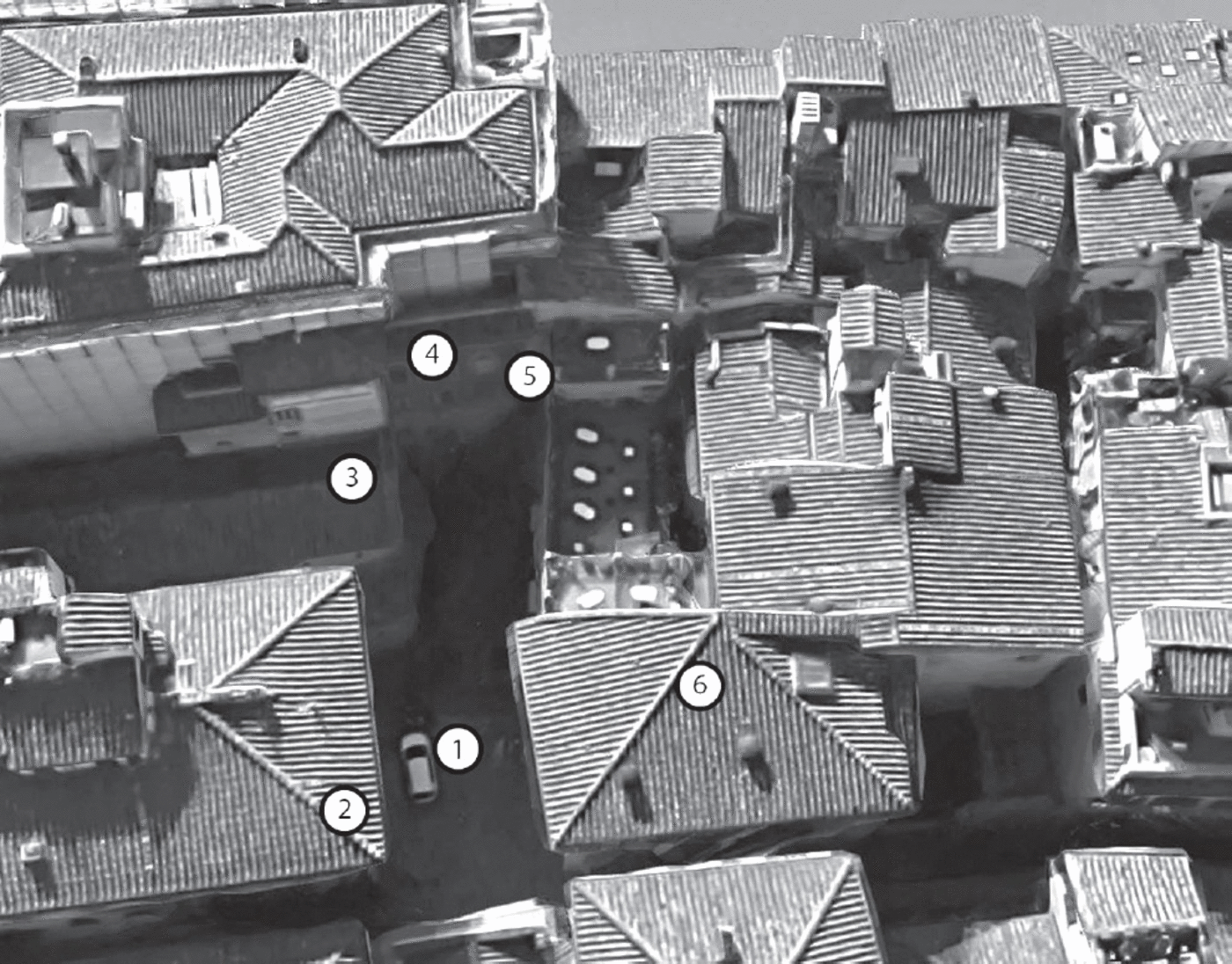
Figure 3. Piazza del Limbo, Florence; aerial view. 1. Piazza del Limbo. 2. Palazzo Borgherini-Rosselli del Turco. 3. Church of Santi Apostoli. 4. Palazzo della Canonica. 5. Chiasso Borgherini (entrance). 6. Palazzo degli Altoviti (Il Palagio—now Hotel Berchielli). © 2018 Google.
Piazza del Limbo, clearly visible on the celebrated Buonsignori map of 1584, already had a complicated history when the first Catasto was conducted in 1427 (fig. 4).Footnote 80 Originally the piazza was named Piazza Santi Apostoli in recognition of the parish. Next to the church in this period, however, was a cemetery for unbaptized infants, which may have been partly or entirely enclosed. Because such children were consigned to the limbus (edge or border) of hell where they were eternally cut off from God’s beatific vision, this site—itself excluded from the sanctified space of the parish church—was known as the Cimiterino del Limbo. Although the infants’ cemetery was eventually swallowed up by development of the church, the name “Limbo” persisted and in time attached itself to the piazza as a whole.Footnote 81

Figure 4. Stefano Buonsignori’s map of Florence, 1584 (detail). Courtesy of the Harvard Map Collection 1. Palazzo Spini. 2. Volta degli Spini. 3. Chiasso Altoviti. 4. Palazzo Altoviti, Il Palagio. 5. Piazza Santi Apostoli / del Limbo. 6. Via detta limbo. 7. Chiasso dei Del Bene. 8. Volte.
This does not mean, however, that a later association simply negated an earlier one, obliterating all memory of the first. The two names jockeyed and competed with each other in the confini of successive Catasti, while the public area directly in front of the church continued to be identified as Piazza Santi Apostoli. In the fifteenth century, as the association with the Cimiterino del Limbo imprinted itself on the local toponymy, it did so without immediately canceling recognition of the parish. The Catasto of 1427 includes numerous instances of householders who cited the parish to locate a property on or in relation to the piazza. Sandro di Vieri Altoviti, an elder who resided in one of his family’s palaces on the corner where the Palazzo Borgherini-Rosselli del Turco stands today, owned a property just across the Borgo, on the northern side, that he described as “a stump of a house opposite the piazza di Santo Apostolo.”Footnote 82 In the same year, Altoviti’s much younger kinsman, Antonio di Antonio Altoviti, also named the “Piazza di Santo Apostolo” when he declared the family palace in which he owned a 50 percent stake on the southern corner where the Borgo met the “Piazza di Santo Apostolo” (fig. 3).Footnote 83 The remainder of this palace belonged to Antonio’s young cousins, Giovanni and Lorenzo, who in addition to asserting their own 50 percent stake identified “a small house next to the said palace on the Piazza di Sancto Apostolo.”Footnote 84 Identification of the Piazza Santi Apostoli persisted alongside appearances of the name “Limbo” throughout the century whenever the Catasto was revived.
Other intriguing nuances surface on scrutinizing the confini’s references to this small area. It emerges, for instance, that the name “Limbo” resonated most strongly at the southern end of the piazza, so much so that it had actually become the name of the alley now named Chiasso Borgherini. A case in point is Caterina, a seventy-year-old former balia (wet nurse) who in 1457 lived next door to members of the Altoviti and Salviati lineages. Caterina located her residence on the “Piazza di Sancto Apostolo,” but she cited the alley as a confine, naming it “via detta limbo” (“the street called limbo”).Footnote 85 Another elderly woman, Spina, who lived in a rented house on the “Piazza di Santo Apostolo,” also listed the “via detta limbo” among her confini in that year.Footnote 86 As the Buonsignori map reveals, this via detta limbo, today more tunnel than street, was once wide enough to constitute a southerly extension of the piazza in front of the church of Santi Apostoli (fig. 4). In other words, the sharp transition from open square to narrow passage that is visible today simply did not exist. This fact helps to explain why several householders did not refer to “via detta limbo” at all, but instead identified “Limbo” as a species of urban micro-zone that Kevin Lynch called a “node.”Footnote 87 Understood thus, the open area between the main piazza and the Lungarno was a place that, having absorbed the name of a well-known local feature—the infants’ cemetery—expressed the genius loci of the neighborhood.Footnote 88
In Florence, the presence of the infants’ cemetery was sufficiently resonant that, in 1457, Benedetto Salviati referred to a knot of chasette (small houses) that he let out as being “in the place called ‘the limbo.’”Footnote 89 Agnolo Carducci used exactly this formulation in 1480 when he declared three chasette in the “place called the limbo.”Footnote 90 “Limbo” seems in an even more generalized sense to have become a colloquial appellation for this locale in the vocabulary of contemporary residents. In 1480, Giovanni di Simone di ser Simone did not even deem it necessary to define the area, and simply declared a property in “limbo.”Footnote 91 A notary, ser Bartolomeo Berti, singled the zone out from the slightly greater distance of his casa di abitazione (house of habitation) on the Lungarno, when he asserted that one of its walls was bordered by “the alley that is nearby limbo.”Footnote 92
Parish church and the lost souls of unbaptized children, however, were not the only contributing elements to the identity of the area that centered on this piazza. Florentine pedestrians arriving from Piazza Santa Trinita in the fifteenth century would have sensed, if they did not already know, that they were entering a zone dominated numerically and architecturally by the Altoviti, one of the city’s oldest aristocratic lineages. These days the only visible traces of the Altoviti’s massive presence are intermittent stretches of rusticated palace facade on both sides of Borgo Santi Apostoli, from just east of the Chiasso Altoviti to the point where a sequence of ground-floor arches terminates in what was once a domestic tower at the corner of Via del Fiordaliso. To stand in the Borgo at the northern edge of Piazza del Limbo in 1427, at the center of this zone, was to be completely encircled by Altoviti kinsmen, palaces, and houses. At the heart of the family’s collective presence was the earlier-mentioned palace now occupied by the Hotel Berchielli, a structure as important as the parish church and the adjacent Cimiterino del Limbo in defining the character of this region of Borgo Santi Apostoli (figs. 3 and 4). The palace was known to locals by a series of names whose resonant simplicity suggests its importance in helping to define the neighborhood’s image: “the palace of Messer Palmieri [Altoviti],” “The palace of the Altoviti,” or, more lapidary still, Il Palagio (the palace).
The Urban Honeycomb
Although it appeared under the name of the young Antonio di Antonio Altoviti and his cousins in the Catasto of 1427,Footnote 93 Il Palagio was not an impregnably segregated or unitary family fortress. Confini reveal the palace instead as a permeable aggregation of dwellings that filled much of the space between Borgo Santi Apostoli and the Lungarno, thoroughly integrated with its urban surrounds and inhabited by an economically diverse community of tenants, many of whom were not Altoviti kin. Among the dwellings that formed part of this complex were three chasette, all “joined together with the above-named palace” and let respectively to a chaplain of the church of Santa Maria Maggiore, the widow of a weaver, and a leather worker.Footnote 94 Directly adjacent, on the eastern side facing Piazza Santi Apostoli, were a fourth chasetta rented by one Margherita da Barga, and a fifth, also “next to the said palace,” which was standing empty in 1427.Footnote 95 An additional pair of chasette appears in the Catasto of 1457. The first, sold by the Altoviti to one Antonio da Pescia prior to 1457, was located on the ground floor sotto le volte (under the arches) of the palace.Footnote 96 The second, once again facing the Piazza Santi Apostoli, was inhabited by the family of the elderly Giovanni della Badessa.Footnote 97
As always, the language of the confini hints tantalizingly at the spatial sensibilities of the socioeconomically disparate community of men and women who inhabited this kaleidoscopic array of overlapping and interpenetrating spaces. Identifying Il Palagio as his residence in the Catasto of 1457, Antonio di Antonio Altoviti, now in his mid-thirties, asserted that he lived in “one half of a palace, among the Altoviti.”Footnote 98 Like Agnolo Spini, Antonio would have experienced a sense of familial pride when he used this locution to ensconce himself discursively in the bosom of his ancient family. One can guess at how someone like the wool weaver Antonio di Guglielmino felt about this reality. At very least he regarded the mass presence of the Altoviti as an inescapable fact of life. One of several tenants who lived on the south side of Il Palagio, Antonio expressed his sense of physical envelopment by Altoviti clansmen in the following words: “I live in a house in the limbo, surrounded on every side by the palace [palagio] of Messer Palmieri Altoviti.”Footnote 99
Cross-referencing the evidential fragments of the confini with a range of other sources sheds additional light on the concentrated spatial reality described in the previous paragraph. Looking at the bird’s-eye view of Il Palagio on the Buonsignori map, it is apparent that what might have appeared at ground level as an undivided edifice in the sixteenth century was in fact a roughly oblong cluster of buildings arranged around a series of connecting open spaces or courtyards (fig. 4). Widening the angle of vision, one sees that this configuration repeated itself. Much of central Florence consisted of these irregular clusters of development, separated from each other by wider thoroughfares. Examples of the latter found close to Il Palagio included the Chiasso Altoviti, far narrower today than formerly, and the Chiasso dei del Bene, which today does not directly link Borgo Santi Apostoli with the Lungarno. Also visible on the map at various points are yawning archways, known as archi or volte, by which citizens could negotiate the capillary networks of alleys and lanes that penetrated and linked these clusters. A number of these structures (examples include the Volta della Vecchia on Via del Parione, the vaults and arches in Via de’ Girolami, the Volta de’ Peruzzi on Via de’ Benci, the Volta San Pierino) have survived to the present day; many more have been lost.Footnote 100 Of the many volte that can be seen on the Buonsignori map, one was located against the southern side of the Spini palace at the corner where the Lungarno meets the southern extremity of Piazza Santa Trinita. A century before the drafting of the Buonsignori map, Domenico Ghirlandaio depicted this volta in the fresco of the Resurrection of the Roman Notary’s Son that he painted for the Sassetti Chapel in the church of Santa Trinita.Footnote 101 The volta is clearly visible in the left background of this fresco, at the far end of the monumental facade of the Spini palace, down which a young boy dressed in red is plummeting headfirst to his death (fig. 5). It can also be seen in the celebrated woodcut, the View with a Chain, executed around 1510 by Lucantonio degli Alberti (fig. 6).Footnote 102
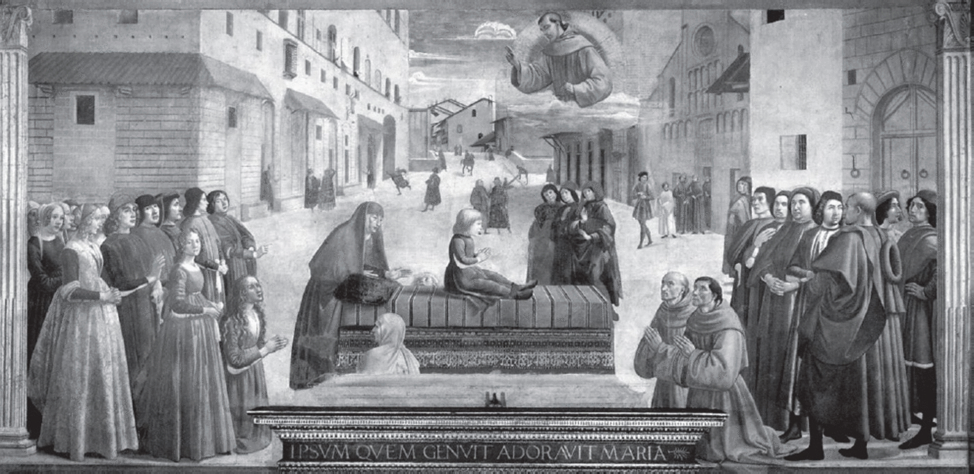
Figure 5. Domenico Ghirlandaio. Resurrection of the Roman Notary’s Son, 1485–86. Sassetti Chapel, Santa Trinita, Florence. Photo: Scala, Florence.

Figure 6. Lucantonio degli Alberti. View with a Chain (detail). Woodcut, ca. 1510. Berlin, Staatliche Museen Preußischer Kulturbesitz, Kupferstichkabinett. © bpk-Bildagentur. The Volta degli Spini is visible in the bottom right corner of the Spini palace.
This archway, which had a name, is specifically identified in an anonymous, unfinished survey of households in each of Florence’s four quarters, carried out in 1525. While the magistracy that ordered the survey and the purpose for which it was conducted are unknown, the written record that it produced evinces the prepositional logic of the confini, and the method of its compilation is clear.Footnote 103 In each quarter, one or more surveyors appear to have walked up and down each street, recording the names of householders, occupants, and their occupations as they went.Footnote 104 In each district of the city, the surveyorFootnote 105 got his bearings by standing in a major piazza, turning through 360 degrees and identifying each major point of access or bocca (mouth).Footnote 106 Thereafter, he plunged into the streets and alleys, recording the male occupants of individual households as he went. Each list consists of a title identifying the street in question and individual entries that name the householders selected for inclusion. One can track the surveyor’s gaze as he identified nine bocche leading in and out of the Piazza Santa Trinita: “The first mouth, of Santa Trinita… .Footnote 107 The Second Mouth is the street, it comes from the Ponte alla Carraia… . The Third Mouth is the Bridge of Santa Trinita… . The Fourth Mouth is the Vault of the Spini along the Arno [volta delli Spini lungo Arno]… . The Fifth Mouth is the street of the Borgo Sancto Apostolo.”Footnote 108
It is the fourth mouth, the “volta delli Spini,” that appears in Ghirlandaio’s fresco and the View with a Chain. On the Buonsignori map this appears as the western opening of a large building that reached roughly as far along the Lungarno as the southern facade of the Spini palace. From the vantage point offered by the Buonsignori map one sees that the palace, which like Il Palagio appeared from ground level to be a single edifice, was also a complex of structures surrounding a considerable amount of open space.Footnote 109 The nature of this openness emerges more clearly if the Buonsignori map’s visual testimony is supplemented with the information culled by the surveyor in 1525. This juxtaposition of sources reveals that, like Il Palagio, the Spini palace was a porous entity whose owners shared it with an unexpectedly diverse population of neighbors, several of them significantly less wealthy and less socially elevated guildsmen who were probably rent-paying tenants. The occupants of the Spini palace appear as a short list, just one of the many of which the survey of 1525 is composed (fig. 7). Like the others, the Spini list strongly recalls the Catasto’s confini, save that its individual entries are not preceded by an ordinal number. I translate it here in full:
The list, which excludes a significant number of women and young children of both sexes, almost certainly understates the size of the socially diverse community that inhabited and worked in the cluster of buildings that formed part of the complex identified with the Palazzo Spini.

Figure 7. 1525 survey of Florence showing list of households identified in Spini palace. The first line of the translated extract is indicated with an arrow. Biblioteca Nazionale Centrale di Firenze, Nuovi Acquisti 987, fols. 5v–6r.
Conclusion
As indicated by the examples cited in this essay, examination of the confini in the Florentine Catasto allows one to reach beyond familiar abstractions to explain how concepts and understandings of urban space emerged from spatial practice at the microscopic level of the individual street, piazza, street corner, or cluster of residential buildings. As the juxtapositions of examples from the Catasto with comparable instances from other towns and cities reveal, the resulting insights have implications beyond their immediate social context, for in composing the bare-bones lists of their neighbors for the Catasto officials, Florentines habitually articulated many of the fundamental terms and concepts by which not only they, but also the inhabitants of other premodern European urban centers, conceived, produced, and daily renewed their relationships with the places, people, buildings, and objects that lay closest to home. Comparing individual examples in this way exposes the connective fibers of small biographies of place in which neither the human protagonists nor the spaces being described make any sense without the other. From this operation, an unusually sharp appreciation emerges of how the fluid toponomastic vocabulary of small urban communities nested within even very large European cities evolved in the crucible of local tradition.


