1. Introduction
The ‘snowball Earth’ scenario of a series of deep and long-lived ice ages in Neoproterozoic time has incited sharp controversy and inspired many sub-hypotheses since it was first proposed by Kirschvink (Reference Kirschvink, Schopf and Klein1992). Particularly contentious are the questions of how extreme the ice ages were (e.g. Hoffman et al. Reference Hoffman, Kaufman, Halverson and Schrag1998; Peltier, Lu & Crowley, Reference Peltier, Lu and Crowley2007); where a photosynthetic biosphere could have persisted under extreme ‘icehouse’ conditions (e.g. Hyde et al. Reference Hyde, Crowley, Baum and Peltier2000; Hoffman & Schrag, Reference Hoffman and Schrag2002); what the oxidative state of the oceans was during and after the climate crisis (Canfield et al. Reference Canfield, Poulton, Knoll, Narbonne, Ross, Goldberg and Strauss2008); and whether the Earth's emergence from the deep ice ages was a result of steady accumulation of volcanic CO2 (Hoffman et al. Reference Hoffman, Kaufman, Halverson and Schrag1998; Hoffman & Schrag, Reference Hoffman and Schrag2002) or sudden release from gas hydrate deposits (e.g. Kennedy, Mrofka & von der Borch, Reference Kennedy, Mrofka and von der Borch2008).
A general consensus has formed that there were two primary intervals of late Neoproterozoic glaciation: one ending by c. 713 Ma (formerly referred to as the ‘Sturtian’ stage) and a second ending at c. 635 Ma (the ‘Marinoan’ stage) (Halverson et al. Reference Halverson, Hoffman, Schrag, Maloof and Rice2005; Bowring et al. Reference Bowring, Grotzinger, Condon, Ramezani and Newall2007). A third, less extensive, glaciation occurred at c. 565 Ma (the ‘Gaskiers’ stage), after the emergence of the oldest known animals but just before the appearance of the Ediacaran fauna (Condon et al. Reference Condon, Zhu, Bowring, Wang, Yang and Jin2005). Beyond this broad framework, however, there is disagreement about how many smaller climate oscillations may have occurred during the late Neoproterozoic and whether the resolution of the geological record is sufficient to correlate specific glacial stages on a worldwide basis (e.g. Allen & Etienne, Reference Allen and Etienne2008). By analogy with the Pleistocene record, it seems likely that there would have been many higher-frequency climate cycles, with repeated advance and retreat of ice sheets, during each of the major periods of glaciation (Pollard & Kasting, Reference Pollard, Kasting, Jenkins, McMenamin, McKay and Sohl2004; Rieu et al. Reference Rieu, Allen, Plötze and Pettke2007). What is clear, in any case, is that extraordinary sequences of glaciogenic rocks occur in Neoproterozoic terranes around the world and that each one can contribute to a clearer understanding of the Earth system at a time of persistent climate instability.
2. Geological setting of the Kapp Lyell Sequence
The Neoproterozoic metasedimentary rocks exposed between Bellsund and Dunderdalen in northern Wedel Jarlsberg Land, SW Spitsbergen, Svalbard (Fig. 1), were interpreted more than a century ago as ancient glacial deposits, and were among the first rocks to be recognized as records of the climate crisis now called the Cryogenian or ‘snowball Earth’ interval (Garwood & Gregory, Reference Garwood and Gregory1898). In spite of this early assignation, their place in the global stratigraphic framework of the Cryogenian Period has remained unclear. After a reconnaissance expedition with Sir Martin Conway along the coast of Spitsbergen in 1896, Edmund Garwood and John W. Gregory described clast-bearing rocks exposed inland from Fox Point in Bellsund (now Renardodden) as ‘tillites’, speculating that they had been deposited as moraines in a setting similar to that of modern Svalbard. Four decades later, however, in the first systematic mapping of the region, Orvin (Reference Orvin1940) examined the strata at Kapp Lyell several kilometres to the west and suggested the name Kapp Lyell Conglomerate, seeing no evidence for direct deposition by ice. Wilson & Harland (Reference Wilson and Harland1964) returned to the glaciogenic interpretation and referred to the sequence as the Kapp Lyell Tillites. Waddams (Reference Waddams1983a) characterized the rocks as ‘resedimented conglomerates’, while Kowallis & Craddock (Reference Kowallis and Craddock1984) suggested that they be called diamictites. All of these workers have been partly correct; the lack of consensus about how to describe these clast-bearing rocks simply reflects the heterogeneous character of the strata in a succession that is more than 2000 m thick. To resolve the nomenclatural confusion, the non-genetic name Kapp Lyell Sequence was formally proposed by Bjørnerud (Reference Bjørnerud1990).

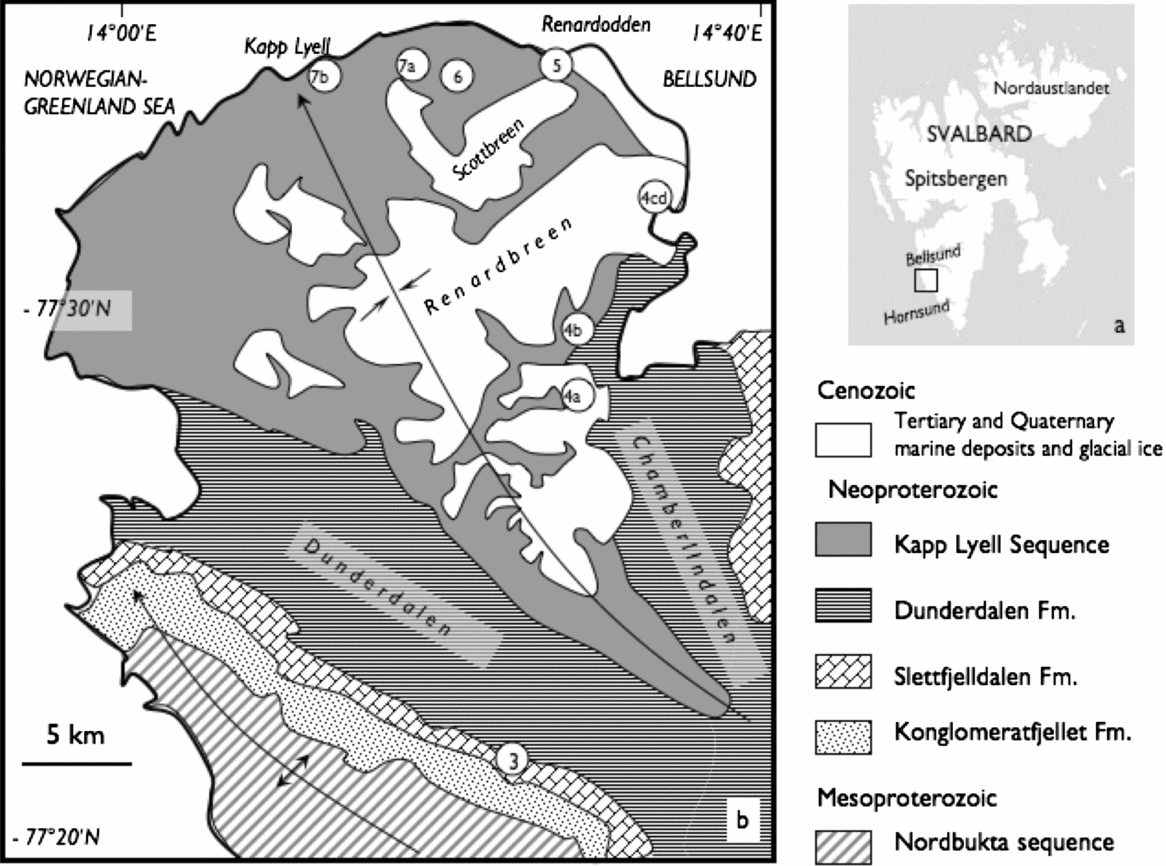
Figure 1. (a) Map of Svalbard archipelago showing location of study area. (b) Simplified geological map of northern Wedel Jarlsberg Land, southwest Spitsbergen showing outcrop area of the Kapp Lyell Diamictites and regional structural features. Circled numbers indicate locations where photographs in Figures 4–7 were taken.
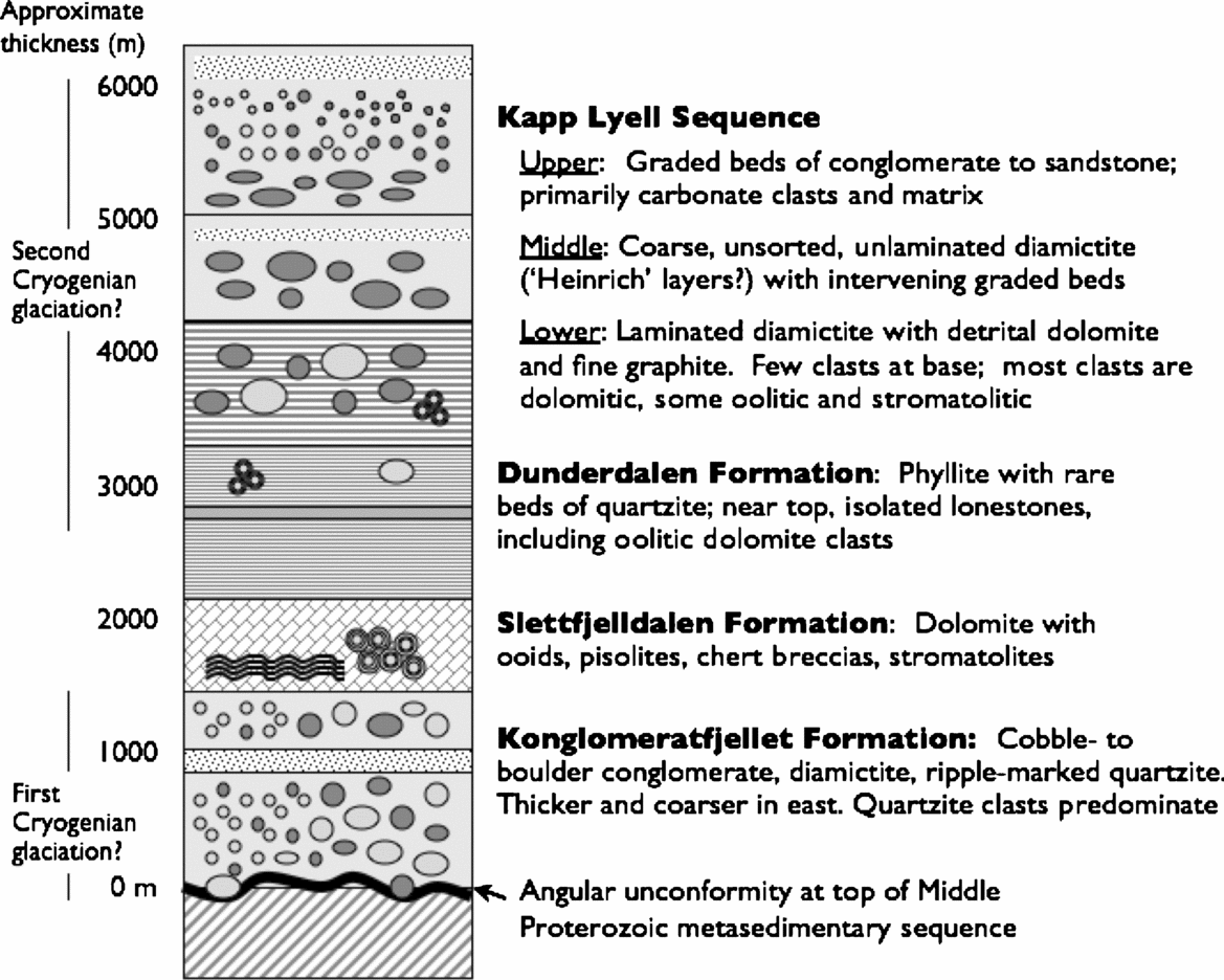
The Kapp Lyell Sequence is the stratigraphically higher of two diamict to conglomeratic Neoproterozoic units exposed in part of the Caledonian-age fold belt of SW Spitsbergen (Figs 1, 2). The lower of these, the Konglomeratfjellet Formation, lies with angular unconformity on an older Proterozoic metasedimentary complex (the Nordbukta Sequence) that experienced deformation and upper greenschist- to amphibolite-facies metamorphism in a tectonic event at c. 950 Ma that may correspond with the Grenville orogeny elsewhere in the North Atlantic region (Bjørnerud, Reference Bjørnerud1990; Bjørnerud, Craddock & Wills, Reference Bjørnerud, Craddock and Wills1990; Johannson et al. Reference Johannson, Gee, Larionov, Ohta and Teben'kov2005). The Konglomeratfjellet Formation is not obviously glaciogenic. It includes metre-thick beds of clast-supported cobble conglomerate; massive, unlayered horizons of boulder conglomerate; diamict layers with evidence of soft sediment deformation and also lenses of ripple-marked sandstone. The Konglomeratfjellet Formation varies in thickness from about 200 m in the western part of northern Wedel Jarlsberg Land, where it tends to be well-stratified, to as much as 1000 m in the east where it is more massive (Bjørnerud, Reference Bjørnerud1990; Dallmann et al. Reference Dallmann, Hjelle, Ohta, Salvigsen, Bjørnerud, Hauser, Maher and Craddock1990). The average size of clasts also increases from cobbles in the west to boulders in the east, suggesting a sediment source to the east. These stratigraphic characteristics were previously interpreted to reflect palaeotopography on the Proterozoic unconformity surface, together with possible syndepositional rifting (Bjørnerud, Reference Bjørnerud1990).

Figure 2. Stratigraphic column showing the position of the Kapp Lyell Sequence within the Proterozoic succession of northern Wedel Jarlsberg Land.
It is notable, however, that the Konglomeratfjellet Formation is topped conformably by dolostones of the Slettfjelldalen Formation (Fig. 2), with distinctive textures: cross-bedding, intraclasts, peloids, digitate stromatolites, mono- and polymict breccias, and outsized ooids or pisolites (Fig. 3), similar to those of ‘cap’ carbonate units in Neoproterozoic sequences elsewhere in the world (e.g. Kennedy, Reference Kennedy1996; James, Narbonne & Kyser, Reference James, Narbonne and Kyser2001; Jiang et al. Reference Jiang, Kennedy, Christie-Blick, Wu and Zhang2006; Hoffman et al. Reference Hoffman, Halverson, Domack, Husson, Higgins and Schrag2007). A limited number of carbon isotope analyses from the Sletfjelldalen formation suggest that δ13C values grow progressively lighter up-section, about 5.5 ‰ at the base to −9.4 ‰ near the top (Table 1). The Konglomeratfjellet Formation could therefore represent deposits from a stage of glaciation that preceded deposition of the Kapp Lyell Sequence, with local topography dictating sediment thickness and character.

Figure 3. Metre-thick bed composed of large ooids or pisolites in Sletfjelldalen dolomite, at type locality south of Dunderdalen (see Fig. 1b). Hammer is 32 cm long.
Table 1. Stable isotope analyses of specimens from Slettfjelldalen Formation and Kapp Lyell diamictite sequence (see Appendix 1. Methods)

The Slettfjelldalen carbonate unit is succeeded by an estimated 2000 m of poorly exposed black phyllite, the Dunderdalen Formation (Fig. 2), which underlies the two main valleys in the area (Dunderdalen and Chamberlindalen; Fig. 1b). The scarcity of outcrop and lack of distinctive marker horizons within this unit make it difficult to map the formation in detail, but in Chamberlindalen, near its contact with the overlying Kapp Lyell Sequence, the phyllite unit includes minor andesitic to basaltic lavas, graded quartzite beds that appear to be turbidite deposits, and rare lone stones of quartzite and dolomite (Bjørnerud, Reference Bjørnerud1990; Kowallis & Craddock, Reference Kowallis and Craddock1984).
3. Age and correlation
No absolute ages are available for the Kapp Lyell Sequence itself, but indirect evidence suggests that it records the second stage of the Cryogenian glaciations at c. 635 Ma. The Konglomeratfjellet, Slettfjelldalen and Dunderdalen formations of northern Wedel Jarlsberg can be unambiguously correlated with the Slyngfjellet Conglomerate, Høferpynten Dolomite and Gåshamna Phyllite formations of the Sofiebogen Group in southern Wedel Jarlsberg Land (Birkenmajer, Reference Birkenmajer, Nairn, Churkin and Stehli1981; Bjørnerud, Reference Bjørnerud1990), exposed north of Hornsund (Fig. 1a). Recently reported U–Th–total Pb monazite dates from the lower part of the Sofiebogen Group include a mode at c. 653 ± 39 Ma, interpreted to record a previously unrecognized pre- or early Caledonian metamorphic event (Majka et al. Reference Majka, Czerny, Manecki and Mazur2007), although no textural link between the monazites and metamorphic or deformational fabrics has been documented and many of the monazites are older detrital grains with thin overgrowths (J. Majka, pers. comm. Jan. 2009). If this monazite peak at 653 ± 39 Ma does represent a metamorphic age for the Sofiebogen group, then both the Konglomeratfjellet Formation and the Kapp Lyell diamictite sequence would have to be older than that age (with its large uncertainty), because there is no evidence for a metamorphic or tectonic break between the two clast-bearing units.
Using these observations to place the Neoproterozoic units of Wedel Jarlberg Land into the global chronostratigraphy of the Cryogenian Period, it seems most likely that the Konglomeratfjellet (and correlative Slyngfjellet) Formation, if glaciogenic, represents the early Cryogenian glacial stage (713 Ma or older) and the Kapp Lyell Sequence records the late Cryogenian stage (ending by 635 Ma) (Condon et al. Reference Condon, Zhu, Bowring, Wang, Yang and Jin2005). Neoproterozoic diamictite sequences elsewhere in Svalbard have traditionally been identified as ‘Vendian’ (Harland, Hambrey & Waddams, Reference Harland, Hambrey and Waddams1993), that is, younger than ‘Sturtian’, but this is based on few absolute ages. The Comfortlessbreen Group and Lågnesbukta sequence, exposed further north along the west coast of Spitsbergen on either side of Isfjorden, bear many similarities with the Kapp Lyell Sequence (Hjelle, Reference Hjelle1969; Waddams, Reference Waddams1983a,Reference Waddamsb). Halverson, Maloof & Hoffman (Reference Halverson, Maloof and Hoffman2004) concluded the Polarisbreen Group of northeastern Spitsbergen and Nordaustlandet (Fig. 1a) most likely records the c. 635 Ma glaciation, with the basal Russøya Member representing a possible cap carbonate to a ‘cryptic Sturtian glaciation’. Significantly, dolostones in the upper part of the Akademikerbreen Group, immediately below the Russøya beds, contain giant ooids (Grotzinger & Knoll, Reference Grotzinger and Knoll1995) very similar to those seen in the Sletfjelldalen Formation, an observation that is consistent with the inferred stratigraphic position of the Kapp Lyell Sequence.
An unnecessary complication to Neoproterozoic correlations within Svalbard has been the oft-cited but largely unsubstantiated hypothesis (Harland, Reference Harland1971; Harland & Gayer, Reference Harland and Gayer1972) that the western, central and eastern parts of the archipelago represent far-traveled Proterozoic terranes that were brought together by large-scale strike-slip displacement in Silurian and Devonian time. Detailed field studies (Dallmann et al. Reference Dallmann, Hjelle, Ohta, Salvigsen, Bjørnerud, Hauser, Maher and Craddock1990; Bjørnerud, Decker & Craddock, Reference Bjørnerud, Decker and Craddock1991; Manecki et al. Reference Manecki, Czerny, Kieres, Manecki and Rajchel1993; Gee & Teben'kov, Reference Gee, Teben'kov, Gee and Pease2004) have now shown that basement sequences can be readily traced across the alleged terrane boundaries. While there may have been some transcurrent displacement along major faults during Caledonian mountain building, there is no evidence that the Proterozoic sequences across Svalbard originated in vastly different parts of the world. Although Harland's hypothesis for the tectonic history of Svalbard has been superceded by later work, he was prescient (Harland, Reference Harland1964) in suggesting that the well-exposed Neoproterozoic sequences of Svalbard provide important information about a wide variety of depositional settings during a major global ice age. Renewed efforts should be made to correlate rocks of this age across the archipelago.
4. Lithostratigraphy of the Kapp Lyell Sequence
The diamictites of the Kapp Lyell Sequence are exposed over an area of approximately 150 km2 in the hinge of a regional NNW-trending synform of Caledonian age, bounded by outer Bellsund and Recherchefjorden on the north and east, Dunderdalen on the southwest and Chamberlindalen on the southeast (Fig. 1b). The total stratigraphic thickness of the Kapp Lyell Sequence is estimated to be 2000–3000 m; mesoscale folding and some internal repetition by thrust faulting preclude a more precise determination. In spite of superimposed deformational structures and lower greenschist facies metamorphism, however, the original sedimentary character of the rocks is generally well preserved and the internal stratigraphy can be reconstructed. Dramatic retreat of Renardbreen, Blomlibreen and other glaciers in the region has left behind ice-smoothed outcrops that were not exposed when the author first mapped the area in detail in the 1980s. This report integrates that previous work with new field observations and geochemical analyses of specimens from an expedition in the summer of 2007.
The contact between the Kapp Lyell Sequence and the underlying phyllites of the Dunderdalen Formation appears to be conformable and gradational, although the surface was a locus of significant shear strain during the early stages of Caledonian deformation (Kowallis & Craddock, Reference Kowallis and Craddock1984; Bjørnerud, Decker & Craddock, Reference Bjørnerud, Decker and Craddock1991), owing to contrasting mechanical properties of the two rock types. The strongest evidence for stratigraphic continuity between these units is the presence of lonestones of pisolitic dolomite within phyllites in the uppermost part of the Dunderdalen Formation that closely resemble clasts found in the lower one-third of the Kapp Lyell Sequence (Fig. 2). On the other hand, the occurrence in both the Dunderdalen Formation and the Kapp Lyell diamictites of carbonate clasts apparently derived from the Slettfjelldalen Formation (see next Section) suggests that disconformity or regressive sequence boundary may separate the Slettfjelldalen and Dunderdalen Formations.
4.a. Laminated diamictite
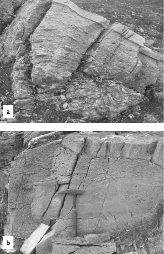
The lowermost part of the Kapp Lyell Sequence is fine-grained and almost clast-free but distinct from the underlying phyllites in having prominent millimetre- to centimetre-scale graded laminae in which sand- to silt-sized grains of quartz and dolomite alternate with submillimetre-thick films of fine white mica and graphite (Fig. 4a, b). The dolomite is clearly detrital in origin. Although somewhat recrystallized, rounded boundaries of original dolomite grains are commonly still visible in thin-section and range from fine sand to pebble size, covarying with the size of nearby quartz grains.

Figure 4. Images of laminated diamicite in the lower 500–1000 m of the Kapp Lyell Sequence. (a) Varve-like laminae in the lowermost, clast-poor part of the Kapp Lyell Sequence. Laminae (crenulated during Caledonian tectonism) are defined by sand- to silt-sized grains of quartz and detrital dolomite, and sub-millimetre-scale layers of fine phyllosilicates and graphite. Small white dolomite pebbles occur in some layers. Hammer is 32 cm long. Location: locally derived talus at base of Beckeaksla, western Chamberlindalen. (b) Closer view of laminae from lowermost Kapp Lyell Sequence. Open folds and a spaced pressure solution cleavage have been superimposed on the layers, but fine grading from sand to finer particles is still visible. In the specimen shown, stratigraphic ‘up’ direction is to the right. Metric ruler shows scale. Location: Activekammen. (c) Laminated diamictite in newly deglaciated outcrops in front of Renardbreen. Spaced cleavage (sub-horizontal) overprints laminae, but in vicinity of large clasts, original sedimentary textures are preserved. Coin at upper right is approximately 2 cm in diameter. (d) Larger view of same outcrop shown in (c), partly covered by recent moraine deposits. Rifle (~ 1 m long) indicates scale.
Within about 100 m of the base of the sequence, the first true diamictite appears. Pebble- to boulder-sized lonestones, presumably ice-rafted, begin to occur with increasingly spatial frequency, even though the rhythmic laminae remain uniform in thickness and composition. This laminated, matrix-supported diamictite subunit is 500–1000 m thick. Although the fine laminae are commonly crenulated and appressed against clasts as a result of Caledonian deformation, dropstone textures are preserved in the strain shadows around large cobbles (Fig. 4c). Dolomite clasts, typically in the range of 3–15 cm diameter, are the predominant type, and many of them have sedimentary features (ooids, pisolites, peloids and stromatolites) that suggest derivation from the underlying Slettfjelldalen formation (Figs 3, 5). Both the dolomite clasts and in situ samples of the Slettfjelldalen formation show considerable variability in δ13C and δ18O values (Table 1).

Figure 5. Large ooids in dolomite clasts within the lower laminated diamictite of the Kapp Lyell Sequence are strikingly similar to those seen in the underlying Slettfjelldalen formation. Coin is approximately 2 cm in diameter. Location: Calypsostranda, north of Scottbreen.
A few intervals within the laminated diamictite contain mainly quartzite cobbles and boulders, which tend to be notably larger than the dolomite clasts, up to a metre in diameter in some instances. Many of these quartzite boulders have ventifact-like polished and pitted surfaces. Minor clast types in the laminated diamictite include greenstone, black limestone, and white to grey marble. Kowallis & Craddock (Reference Kowallis and Craddock1984) also reported finding rare detrital pyrite, although this has not been observed by the author. Pyrite does occur as selvages along pressure solution cleavage surfaces and around the margins of clasts, especially quartzites. However, total S concentrations in several analysed samples of the laminated diamictite are less than 0.09% (Table 2).
Table 2. Carbon, sulphur and iron concentrations in matrix of laminated diamictite, lower Kapp Lyell Sequence

Values reported as weight percents. TIC = Total inorganic carbon; TOC = Total organic carbon; FeT = Total Fe; FeHR = Highly reactive Fe (principally in pyrite, magnetite, ferric oxides, carbonate minerals; Poulton & Raiswell, Reference Poulton and Raiswell2002). See Appendix 1. Methods.
All samples were collected from recently deglaciated outcrops at front of Renardbreen (Fig. 1b).
The fine-grained laminae in the lower one-third of the Kapp Lyell Sequence would appear to be suspension deposits, and their extraordinary uniformity points to repetitive (e.g. tidal or seasonal) depositional cycles that continued even as coarser ice-rafted debris began to enter the basin at an increasing rate. If these millimetre- to centimetre-scale layers were annual, the 500–1000 m thick laminated section would represent a minimum of 50 ka to as much as 1 Ma.
The consistent occurrence of graphite in the fine fraction of the rhythmic laminae is intriguing. Carbon isotope analyses of this graphitic material from samples collected from the lowest clast-bearing strata of the Kapp Lyell Sequence at Activekammen and Crammerbreen, just south of Renardbreen (Fig. 1b), yield δ13C values between −20 and −22 (Table 1), pointing to a biogenic origin. The total organic carbon content of the fine laminae is low, however (0.3–1.2%; Table 2), and the isotope values are somewhat higher than would be expected from typical phytoplankton production. It is likely, therefore, that greenschist-facies metamorphism led to some loss of light organic carbon. On the other hand, carbon and oxygen isotope values from dolomite clasts within this interval show a considerable range of values, with δ13C ranging from 1.84 to 6.4 ‰ (Table 1). This variability and the large difference in δ13C values between the graphite and carbonate samples (~ 24 ‰) indicates that limited isotope exchange has occurred between the carbonate and graphite phases and that metamorphic temperatures probably did not exceed 300°C (Morikiyo, Reference Morikiyo1984; Valley & O'Neil, Reference Valley and O'Neil1986; Scheele & Hoefs, Reference Scheele and Hoefs1992), which is consistent with observed mineral assemblages (Bjørnerud, Decker & Craddock, Reference Bjørnerud, Decker and Craddock1991).
Although metamorphism may have partly shifted their carbon isotope values, the repetitive graphitic laminae are most simply interpreted as evidence of the sustained presence of a seasonally active marine biosphere during the latter part of a ‘snowball’ cycle (cf. Corsetti et al. Reference Corsetti, Olcott and Bakermanns2006). It is possible that the carbon was derived from older organic matter that was delivered to the basin with other suspended sediments, but this would require that the ice delivered a uniform amount of recycled organic carbon to the basin year after year.
Iron speciation analyses of the matrix of the laminated diamictite yield very high ratios of highly reactive Fe (FeHR) to total Fe (FeT; Table 2). FeHR occurs as pyrite and phases reactive enough to form pyrite (magnetite, ferric oxides, carbonate minerals) during deposition or early diagenesis, while FeT includes FeHR as well as Fe in silicate phases, which are typically unreactive (Poulton, Fralick & Canfield, Reference Poulton, Fralick and Canfield2004). As such, FeHR/FeT is an indicator of the degree of anoxicity of the water column and sediment–water interface at the time of deposition (Poulton & Raiswell, Reference Poulton and Raiswell2002). FeHR/FeT values greater than 0.38 correspond to anoxic conditions (Poulton, Fralick & Canfield, Reference Poulton, Fralick and Canfield2004), and all of the samples from the laminated diamictite yielded values well above this (Table 2). The low S concentrations in the same samples indicate, however, that pyrite is not a major phase, and therefore suggest that the bottom waters of the basin in which the diamictites accumulated were low in oxygen but probably Fe(II)-rich, not sulphidic (Canfield et al. Reference Canfield, Poulton, Knoll, Narbonne, Ross, Goldberg and Strauss2008). Interpretation of the FeHR/FeT ratios for the laminated diamictite is complicated, however, by the fact that much of the matrix consists of detrital dolomite.
4.b. Massive diamictite and coarse-grained turbidites
The laminated diamictite interval ends abruptly with the appearance of unlayered, unsorted diamicite in beds 1–5 m thick. The volumetric ratio of matrix to clasts in these diamictites is significantly lower than that in the laminated interval. Clasts range from sand to boulder size. Dolomitic clasts remain the predominant type, and much of the finer sand-sized material is also dolomitic. Caledonian deformation has created a strain shape fabric that looks superficially like bedding, but there is no primary internal layering; intervening graded layers of conglomerate to sandstone provide the only indication of the orientation of bedding (Fig. 6). The massive diamictite interval is at least 500 m thick, with such graded beds becoming more and more common up-section.

Figure 6. Well-sorted sandstone bed overlain by an unsorted diamict layer. Strong tectonic flattening of black limestone clasts creates an illusion of layering in the diamictite. Compass near sandstone layer is 7 cm in diameter. Location: foot of Wijkanderberget.
The uppermost 1000–1500 m of the Kapp Lyell Sequence consists almost entirely of coarse graded beds, 1–2 m thick, with only rare unsorted intervals. These turbiditic deposits are apparently the rocks Waddams (Reference Waddams1983a) described as ‘resedimented conglomerate’, and they would seem to represent primarily ‘A’ and ‘B’ units of the canonical Bouma sequence. These beds typically include 20–30 centimetres of pebble-sized conglomerate that grades upward to sand (Fig. 7a). As in the lower parts of the Kapp Lyell Sequence, much of the sand-sized fraction is dolomitic. Most of the sandy intervals have planar internal layering, although 10 cm-scale cross-bedding occurs locally. The uppermost parts of the sandy intervals are commonly truncated by overlying conglomerate, suggesting high-energy scouring. Individual graded beds are traceable for hundreds of metres, although they are sometimes disrupted by metre-scale flame structures, suggesting that the sediments were very water-rich and incompletely compacted when the succeeding layers were deposited. The average grain size decreases up-section, with conglomeratic intervals gradually becoming less common. At Kapp Lyell itself, the rocks are mainly gritstones (Fig. 7b). These beds are the youngest preserved Neoproterozoic strata in the region.

Figure 7. Coarse, turbiditic beds become more and more prevalent in the upper part of the Kapp Lyell Sequence. Conglomeratic intervals (a) grade into coarse, plane-bedded sandstone layers (field of view about 2 m wide. Location: Blomlidalen). At Kapp Lyell itself (b), the rocks are mainly gritstones that commonly show flame structures. Hammer is 32 cm long.
The sedimentary characteristics of both the unsorted, massive diamictites and the coarse turbiditic beds in the upper part of the Kapp Lyell Sequence suggest rapid, energetic deposition. It seems likely that the upper half to two-thirds of the sequence may have been laid down in only a fraction of the time that it took for the lower laminated part to accumulate, perhaps as little as a few thousand years (Pollard & Kasting, Reference Pollard, Kasting, Jenkins, McMenamin, McKay and Sohl2004).
5. Interpretations and conclusions
The Kapp Lyell Sequence of diamictites, conglomerates and sandstones appears to be the glaciomarine record of the collapse of a land-based ice mass, probably during the second (‘Marinoan’) phase of Cryogenian glaciation. The lowermost, clast-poor, rhythmically laminated unit in the sequence seems to represent suspension deposits from subglacial discharge (Powell, Reference Powell1981) in a setting where calving from the icefront was suppressed, possibly because of buttressing by an ice shelf (Hulbe et al. Reference Hulbe, MacAyeal, Denton, Kleman and Lowell2004), multi-year shore-fast ‘sikussak’ ice (Dowdeswell et al. Reference Dowdeswell, Whittington, Jennings, Andrews, Mackensen and Marienfeld2000) or by ice grounded on the seafloor (Dowdeswell et al. Reference Dowdeswell, Otteson, Evans, Cofaigh and Anderson2008). The apparently biogenic films of graphite within these laminae, however, suggest that waters nearby were open and receiving enough light to support a community of photosynthetic micro-organisms.
The increasing number of lonestones in the laminated unit beginning about 100 m above the base of the sequence indicates that calving rates accelerated progressively even as background deposition of fine suspended sediment continued. The overwhelming predominance of carbonate clasts and the presence of detrital dolomite in the matrix indicates that the ice sheet had picked up much of its sediment load from a carbonate terrane and that chemical weathering was minimal. Much of the fine-grained matrix of the diamicite probably represents dolomitic ‘rock flour’ produced by glacial abrasion. It is interesting to note that Pleistocene ‘Heinrich’ layers were first defined in North Atlantic sediment cores as ‘percentage increases in detrital carbonate above ambient values’ (Bond et al. Reference Bond, Showers, Elliot, Evans, Lotti, Hadjas, Bonani, Johnson and Clark1999, p. 481). Distinctive sedimentary features (ooids, pisolite, stromatolites) in many of the dolomite clasts in the Kapp Lyell diamictites suggest that they were derived from the underlying Slettfjelldalen formation, a carbonate platform that may have been stranded above water as a result of sea-level fall during glaciation. Less common quartzite clasts are typically larger and show evidence of long-term exposure to wind. These very resistant clasts may have been derived from nunataks further inland and may have been carried by the ice mass in medial moraines of distinct composition.
The preservation of organic carbon, the high ratios of reactive to total iron, and the low sulphur content in the laminated diamicite matrix suggests that low-oxygen, but not euxinic, conditions prevailed on the floor of the basin in which the sediments accumulated. This is consistent with the hypothesis of Canfield et al. (Reference Canfield, Poulton, Knoll, Narbonne, Ross, Goldberg and Strauss2008) that the world's deep oceans returned to a ferruginous state at the close of the Proterozoic after a billion years of sulphidic conditions, perhaps as a result of decreased sulphate delivery to the oceans during the snowball Earth period.
The basin in which the Kapp Lyell Sequence accumulated must have been exceptionally deep, rapidly subsiding and/or deepening as a result of sea-level rise, to accommodate 2000 to 3000 metres of glaciogenic sediment. If the millimetre- to centimetre-scale layers in the laminated interval are annual varves, the lower part of the sequence would represent a period of 105 to 106 years. In contrast, the overlying massive diamictite and turbiditic deposits, which represent between one-half to two-thirds of the total thickness of the sequence, may have been laid down in only a few millennia.
The abrupt transition from laminated diamicite to coarse, unsorted, unlayered diamictite points to deposition by ‘iceberg armadas’ like those launched by the collapse of the Laurentide ice sheet (Broecker, Reference Broecker1994; Bond et al. Reference Bond, Showers, Elliot, Evans, Lotti, Hadjas, Bonani, Johnson and Clark1999). Break-up of an ice shelf, disappearance of buttressing sikussak ice, hydrological changes at the base of the glacier and/or sudden slippage of grounded submarine ice (Hulbe et al. Reference Hulbe, MacAyeal, Denton, Kleman and Lowell2004; Dowdeswell et al. Reference Dowdeswell, Otteson, Evans, Cofaigh and Anderson2008) may have unleashed flotillas of icebergs and large volumes of glacial sediment into the basin. Ice front calving, together with the break-up of the icebergs and dumping of massive amounts of detritus into the basin would have triggered turbidity flows that partly reworked and sorted the sediment into layered conglomerates and sandstones (Powell, Reference Powell1981).
While the collapse of the Kapp Lyell ice sheet seems, from the sedimentary record, to have been sudden, this stratigraphic section, like other Cryogenian sequences around the world, neither refutes nor supports the two prevailing hypotheses for the end of the second Cryogenian glaciation: (1) sudden volatilization of submarine methane clathrates (Jiang et al. Reference Jiang, Kennedy and Christie-Blick2003; Kennedy, Mrofka & von der Borch, Reference Kennedy, Mrofka and von der Borch2008) or (2) the more gradual accumulation of volcanic carbon dioxide (Hoffman & Schrag, Reference Hoffman and Schrag2002). The true story of the Cryogenian Period is likely to be far more complex (Rieu et al. Reference Rieu, Allen, Plötze and Pettke2007), and it may be unrealistic to assume that simple global patterns can be recognized in the surviving fragments of the Neoproterozoic geological record.
Although they were one of the first Neoproterozoic sequences to be recognized as glaciogenic, the Kapp Lyell diamictites probably record only the very end of an ice age. It seems likely that the story of full glacial conditions in the Cryogenian Period in this part of Svalbard may actually be found in the poorly exposed, undifferentiated black phyllites of the underlying Dunderdalen formation. The Kapp Lyell diamictites themselves would seem to chronicle the catastrophic collapse of an ice sheet, an ironic conclusion to be drawn from rocks named for the father of Uniformitarianism.
Acknowledgements
The author is deeply grateful to Noah Planavsky (UC-Riverside) and Chad Lane (Lawrence University) for providing geochemical and isotopic analyses; Jerzy Czerny and Maciej Manecki (AGH-Krakow) for logistical field support through an International Polar Year Grant; Prof. Jerzy Melke, Marte Melke, Nikolay Kuznetsov and Emily Thiem for their generosity and good humour. Funding for this study came from a Lawrence University Faculty Research Grant and the Walter Schober Professorship in Environmental Studies.
Appendix 1. Methods
Stable isotope analyses
Organic and carbonate carbon isotopes were determined using a Finnigan MAT Delta-plus isotope ratio mass spectrometer coupled to an elemental analyser and a gas bench, respectively. Carbonate analyses were carried out at the University of California–Riverside, and organic carbon analyses were done at the University of Tennessee. Sub-samples of the graphite laminae were removed from rock samples using a Dremel® tool. The graphite powder was reacted with a weak (10%) HCl solution to remove carbonate-derived inorganic carbon and neutralized with no fewer than three washesof distilled water. The graphite samples were then dried at 50°C overnight. All carbon isotopic compositions are reported in standard δ-per mil notation relative to the Vienna-Pee Dee belemnite (VPDB; Coplen, Reference Coplen2006). Precision, based on multiple analyses of international standards, is better than 0.2 ‰.
Geochemical analyses
Total sulphur and carbon concentrations were determined using an Eltra CS-800 carbon/sulphur determinator, which has a precision of better than 0.2%. Highly reactive Fe concentrations (FeHR) were determined using the ferrozine method (Stookey, Reference Stookey1970) after a one-minute boiling HCl extraction (Berner, Reference Berner1970; Raiswell & Canfield, Reference Raiswell and Canfield1998). Total sample Fe (FeT) was assumed to be extracted through exposure to boiling 12M HCl for 24 hours after sample ashing (12 hours at 800°C) (Poulton & Canfield, Reference Poulton and Canfield2005). Total Fe concentrations were also determined using the ferrozine method (Stookey, Reference Stookey1970). The error of the method is 4%.