


Precolonial mounds in Uruguay, Argentina, and the Brazilian state of Rio Grande do Sul that are related to aquatic environments are traditionally referred to as cerritos. In these mounds are found lithic, ceramic, and zooarchaeological artifacts; burial sites; and large hearth features (Figure 1).
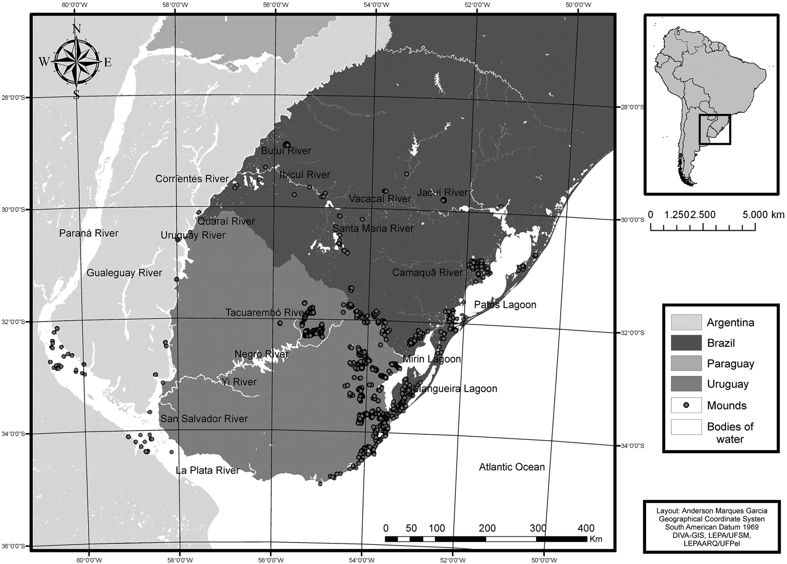
Figure 1. Map showing reported mounds within the Southern Cone (Garcia Reference Garcia2017).
The known dates for this type of archaeological structure of the Southern Cone indicate that the first cerritos were built approximately 5000 cal BP in Uruguay (Gianotti Reference Gianotti2016; López Mazz Reference López Mazz2001). The most recently obtained dates show that they were still being produced at a time close to the conquest of the region by Iberian settlers (Bonomo et al. Reference Bonomo, Politis and Gianotti2011; Iriarte Reference Iriarte2006; López Mazz Reference López Mazz2001; Schmitz Reference Schmitz1976; Schmitz et al. Reference Schmitz, Naue, Becker and Kern1991).
Based on local variations, these widely distributed structures have been interpreted in different ways—as cemeteries, means of demarcating territories, middens, central squares of villages, elevated habitation sites within wetland environments, or monuments linked to the memory and identity of the groups that built them (Bonomo et al. Reference Bonomo, Politis and Gianotti2011; Gianotti Reference Gianotti2016; Iriarte Reference Iriarte2006; López Mazz Reference López Mazz2001; López Mazz and Bracco Reference López Mazz and Bracco2010; Schmitz Reference Schmitz1976).
Since the nineteenth century, this type of archaeological site has attracted the attention of pioneers such as José Henriques Figueira in Uruguay and Estanislao Zeballos in Argentina (Figueira Reference Figueira1957; Zeballos and Pico Reference Zeballos and Pico1878). But research in Brazil has only been systematically conducted since the 1960s, primarily by the National Archaeological Research Program (PRONAPA). Working under the auspices of PRONAPA, Schmitz (Reference Schmitz1976) proposed the first synthesis on cerritos in Brazil, interpreting them as seasonal fishing grounds occupied for long periods and adapted for housing between summer and spring. Schmitz claimed that the marshy lowlands in the southwestern region of the Patos Lagoon attracted fish, mammals, and birds, providing a robust subsistence base for the builders of the cerritos. Between the 1960s and 1980s, additional studies were conducted on mounds in the coastal and interior regions of Rio Grande do Sul.
In Rio Grande do Sul, the use of the term cerrito traditionally referred to monticule archaeological phenomena, with which vestiges of the Vieira pottery tradition were associated. The Vieira tradition was classified as a late phase within the Umbu tradition, related to hunter-gatherers. Vieira material culture has been found within cerritos and dunes, near watercourses, and on hills; it typically consists of remnants of small, simple containers, usually without decoration (Brochado et al. Reference Brochado, Calderón, Chmyz, Dias, Evans, Maranca, Meggers, Miller, Nasser, Perota, Piazza, Rauth, Simões and Simões1969). Ricardo Ribeiro (Reference Ricardo Ribeiro2016) recently argued that these objects were not simple because of a lack of technical ability; instead, their design was the product of a deliberate choice, given that objects exhibiting a greater number of finishing details were also identified.
In Brazil, few studies were carried out on cerritos and Vieira material culture during the last two decades of the twentieth century. Studies of cerritos began to be conducted again in the first decade of the twenty-first century, following the emergence of new colleges in the region and mainly influenced by topics related to the New Archaeology discussed in Uruguay. Nevertheless, this region also exhibits mound features other than cerritos. These include Uruguayan stone mounds known as cairns, the builders of which are still uncertain (Soteldo Reference Soteldo2018), burial mounds associated with Jê groups from plateaus in Rio Grande do Sul (Copé Reference Copé2015), shell mounds on the north coast of Rio Grande do Sul related to the populations whose subsistence was primarily based on fishing (Schmitz Reference Schmitz1991), and subtle mounds in the central region of Rio Grande do Sul related to hunter-gatherer groups (Garcia Reference Garcia2016).
In a historical analysis of the development of archaeological research in Brazil, I discussed the diversity of mound sites in Rio Grande do Sul, showing how different kinds of sites were classified either as cerrito or Vieira (Garcia Reference Garcia2019). I continue this discussion in this article by analyzing material artifacts from two kinds of mound sites: (1) cerritos from the coast and (2) mounds from the interior of Rio Grande do Sul. This research began with the study of three sites located within the southwestern region of the Patos Lagoon in the county of Pelotas, which had been occupied by sedentary social groups that used ceramic technology. They had a mixed hunting-gathering-fishing economy and possibly domesticated certain plants. Many of these mounds are associated with human burials and were likely occupied between 2500 and 1000 cal BP (Milheira et al. Reference Milheira, de Souza and Iriarte2019; Milheira, Macario et al. Reference Milheira, Macario, Chanca and Alves2017; Von Mühlen Reference Von Mühlen2014). I also analyzed a mound from the interior of Rio Grande do Sul, within the highland region of the central portion of the state near the modern city of Pinhal Grande. It exhibited domestic features and evidence of use as a production area for stone tools, associated with a hunter-gatherer group (Garcia Reference Garcia2013, Reference Garcia2016, Reference Garcia2017).
Cerritos of the Southwestern Patos Lagoon
The first three sites studied are located in the southwestern region of the Patos Lagoon, in the county of Pelotas. This area was not investigated by PRONAPA. Within the county of Pelotas itself, there are two sites: PT 02 (Cerrito da Sotéia) and the multiple mounds that comprise Cerritos Pontal da Barra. In the city of Capão do Leão, there are the cerritos of Lagoa do Fragata (Figure 2; see also Supplemental Figures 1–3).

Figure 2. Map showing the location of cerritos within the southwestern Patos Lagoon region and adjacent to the cities of Pelotas and Capão do Leão, including vegetation and bodies of water.
The environment in which the cerritos of the Pelotas region are found consists primarily of flat wetlands encompassing a series of small ponds. Most of the mounds are less than 800 m from the current Patos Lagoon coast, with the exception of the cerritos of Lagoa do Fragata, which were built approximately 16 km from the Patos Lagoon.
The main watercourses of the region are the Pelotas Stream and the São Gonçalo Canal. The Pelotas Stream originates in Serra do Sudeste and crosses crystalline formations of the Escudo Sul-riograndense (South Riograndense Shield) and the plain, where it becomes a meandering river until it exits into the São Gonçalo Canal. This canal receives water from many local courses. It consists of a natural link between the Patos and Mirim Lagoons, to the southwest of this research area. Other important smaller courses, named based on their proximity to cerritos sites, include the Corrientes Stream, which flows into the Pequena Lagoon (west of the PT 02–Cerrito da Sotéia) and the Moreira Stream, which flows into the northeastern Fragata Lagoon. The ecology of the area predominantly comprises Atlantic forest and pampa, further classified as the phytoecological regions of steppe, semideciduous seasonal forest, and pioneer formations (Cordeiro and Hasenack Reference Cordeiro, Hasenack, Pillar, Müller, Castilhos and Jacques2009).
It is also worth noting that the archaeological sites in the southwestern Patos Lagoon are located within the coastal plain. This geomorphological region does not present rocky outcrops, but to the northwest of these sites can be found the Escudo Sul-riograndense, a pre-Cambrian geomorphological formation composed of different varieties of granite (Chemale Reference Chemale, Holz and de Ros2000; CPRM 2006).
PT 02–Cerrito da Sotéia
The archaeological site PT 02–Cerrito da Sotéia, located on the sandbanks of Feitoria Island, was the subject of Loureiro's (Reference Loureiro2008) master's thesis. Based on both ceramic and zooarchaeological artifacts and the ellipsoidal shape and low elevation of the structure, Loureiro interpreted the site as a base camp for the exploitation of lacustrine resources. He suggested that the artifacts collected from the site did not exhibit definite stylistic variations and that this space could have been used as a disposal area for small village materials. This latter hypothesis is based on the presence of low-elevation features that may have been housing areas.
The radiocarbon dates of otoliths recovered from the site yield a date of 1400 ± 40 BP (Beta-234207) at the base of the structure and 1360 ± 40 BP (Beta-234206) at the top, respectively calibrated (Marine 13 curve) with 2σ from 1256 cal BP to 1031 cal BP and from 1215 cal BP to 976 cal BP. Based on these data, Loureiro (Reference Loureiro2008) argued that Cerrito da Sotéia experienced an intense but brief occupation. This hypothesis was supported by the abundant faunal and pottery remains, despite the short time span between the dates from the top and bottom of the mound.
Belletti (Reference Belletti2010) studied the ceramic artifacts of this cerrito, finding that the pottery sherds came from small utilitarian pots, without molded decoration. Nevertheless, she argued that these specimens did exhibit different types of surface treatment. For example, she identified a part of a small vessel that was interpreted as a possible miniature used in the process of teaching and learning among the potters.
Ulguim (Reference Ulguim2010) analyzed the faunal remains found at this site. Of the 70,636 artifacts, Ulguim determined that 68% belonged to the Osteichthyes class. She also concluded that, of the total biomass represented by these fragments, 93% belonged to the class Osteichthyes, 4% to Mammalia, 2% to Reptilia, and 1% to Malacostraca. Among the Mammalia class, the noteworthy finds are a pendant made of a dolphin tooth (Tursiops truncatus) and projectile points from deer metapodia (Mazama).
In 2010, I reported the first observations of the lithic technology and revisited this collection with Milheira in 2011 (Garcia Reference Garcia2010; Garcia and Milheira Reference Garcia and Milheira2011). In 2017, I reported on same collection, along with materials from the two other sites of the southwestern Patos Lagoon discussed in this article (Garcia Reference Garcia2017). The collection of lithic artifacts from Cerrito da Sotéia consists of 501 objects. Quartz is the primary raw material (n = 364), particularly of the production debris. The remaining artifacts consist of basalt (n = 49), andesite (n = 46), granite (n = 37), and rhyolite (n = 5). The most common (>80% of artifacts) production technique was bipolar percussion using an anvil (Figure 3; see also Supplemental Table 1).

Figure 3. Example of an andesite cutting instrument.
Pontal da Barra
Pontal da Barra is located at the confluence of the São Gonçalo Canal and the Patos Lagoon. Eighteen cerritos were identified in this area between 2006 and 2009 (Milheira Reference Milheira2014).
A set of 24 dates was run on samples from the cerritos PSG01, PSG02, PSG03, PSG06, and PSG07. Based on the results of this assay, Milheira, Macario, Chanca, and Alves (Reference Milheira, Macario, Chanca and Alves2017) proposed a model for the length and nature of the occupation at Pontal da Barra. They interpreted the hearths found at the base of the cerritos as evidence of camps for the exploitation of seasonal fish. These base camps mark the initial occupation of the site at around 2200 BP.
Over time, the population increased, and a more permanent village settlement formed between 1800 and 1200 BP. The inhabitants practiced landscape management, constructing raised platforms for residences, secondary burial sites, and possible agricultural areas. These cerritos were simultaneously occupied by around 1500 BP, which suggests both stability and a sedentary lifestyle. Nevertheless, the occupation appears to have been interrupted around 800 BP, although the causes of the abandonment of the site are not clear (see the complete dating sequence in Milheira, Macario et al. Reference Milheira, Macario, Chanca and Alves2017:207).
The researchers performed a survey of the central area of these cerritos using ground-penetrating radar (GPR). This survey identified three circular or elliptical anomalies and a V-shaped feature, which have been interpreted as possible signs of building in the area beyond the mounds. The V-shaped feature may be the remnant of a canal made by the builders of Pontal da Barra, and the circular anomalies could be the remains of other domestic structures (Milheira et al. Reference Milheira, Ricardo Ribeiro, Garcia, Ulguim, Munsberg, Ulguim and Dias2015).
Ricardo Ribeiro (Reference Ricardo Ribeiro2016) analyzed 839 pottery sherds from PSG 03, PSG 04, and PSG 07: they corresponded mostly to basins and pots and exhibited different types of surface treatments and clay sources. Molded decorations similar to that of corrugated Guarani ware were identified, but the author emphasizes the originality and heterogeneity of this pottery. These decorations were not Guarani imitations, as is traditionally claimed in the regional literature.
Zooarchaeological data are limited to the PSG 02 sample, which nevertheless does suggest a slight similarity with that of Cerrito da Sotéia. In PSG 02, the sample is dominated by the Osteichthyes class. The representatives of the Mammalia class include two premolar teeth from domestic dogs (Canis lupus familiaris) and a pendant made of a dolphin tooth (Tursiops truncatus; Milheira et al. Reference Milheira, Ricardo Ribeiro, Garcia, Ulguim, Munsberg, Ulguim and Dias2015; Milheira, Loponte et al. Reference Milheira, Loponte, Esponda, Acosta and Ulguim2017; Milheira, Macario et al. Reference Milheira, Macario, Chanca and Alves2017).
In addition to the faunal remains, disjointed human bones were identified in PSG 01, PSG 02, PSG 04, PSG 06, and PSG 07. In PSG 02, a fragmented human jaw, corresponding to a male individual, was found in association with the dolphin tooth pendant (Ulguim and Milheira Reference Ulguim and Milheira2017). An analysis of palynological data is so far only available from PSG 01 and PSG 02, which exhibit Zea mays and Cucurbitaceae pollen, indicating the presence of corn and squash in these structures (Soares Reference Soares2014; Von Mühlen Reference Von Mühlen2014).
The lithic material from Pontal da Barra currently consists of 297 objects from PSG 01 to PSG 07. The lithic industry predominantly comprises quartz (n = 164) and granite (n = 128) artifacts, as well as the debitage resulting from the production and use of these instruments. Other production materials (n = 5) are rhyolite, friable sandstone, basalt, and an undetermined raw material (Figure 4).

Figure 4. (a) example of a fragment of a granite artifact with a semi-spherical depression, delineated by the white dashed circle, with a dash indicating horizontal fracture; (b) instrument used as a manual polisher with the flattened area indicated by the white arrow and with two semi-spherical depressions on one side delineated by white circles.
Bipolar flakes (n = 125) and angular shatter from bipolar percussion (n = 121) dominate the collection. This indicates that, just as with Cerrito da Sotéia, bipolar percussion was the primary production method at Pontal da Barra (see also Supplemental Table 2).
Lagoa do Fragata
Lagoa do Fragata is located in the northeastern portion of the city of Capão do Leão, practically bordering Pelotas. The research, which started in 2010 under the direction of Rafael Guedes Milheira, identified the first 2 of the 10 cerritos that are now known to make up the site of Lagoa do Fragata. This research was motivated by the discovery in the 1980s of two zoolites, or stone zoomorphic sculptures, in the study area (Milheira Reference Milheira2011).
Peçanha (Reference Peçanha2014) continued the archaeological mapping and proposed that most cerritos in this area were the site of occupations following the natural topography of sandy deposits extending over natural reliefs of low elevation. Over time, the ancient inhabitants would have modified and elongated the shape of these mounds. Nevertheless, he points out that the top of the PSGLF mound comes to two points. When compared to twinned buildings previously identified in Argentina (Bonomo Reference Bonomo, Politis and Gianotti2011) and Uruguay (Gianotti Reference Gianotti2016), this shape could be possible evidence of architectural complexity (Milheira et al. Reference Milheira, Garcia, Ricardo Ribeiro, Ulguim, da Silveira and Sanhudo2016; Peçanha Reference Peçanha2014).
PSGLF 02 was the subject of Cleiton Silva da Silveira's master's thesis. He opened four excavation areas in 2014. Although the researcher discontinued work on this project, it is important for this present discussion because it discussed the lithic artifacts from the site. Cerrito Pavão 1, which forms part of Lagoa do Fragata, was subsequently studied by Sanhudo (Reference Sanhudo2017), who analyzed the architecture of these structures by means of geoelectric and electromagnetic surveys, using total station, GPR, and a drone.
The ceramic and zooarchaeological collections are currently under analysis. Nevertheless, the preliminary results of this work indicate that once again representatives of Osteichthyes dominate the collection, particularly croaker (Micropogonias furnieri), black drum (Pogonias cromis), and catfish (Ariidae catfish). This pattern is consistent with that seen at Cerrito da Soteia (Milheira et al. Reference Milheira, Garcia, Ricardo Ribeiro, Ulguim, da Silveira and Sanhudo2016).
Discussion of the stone tools is limited to those from PSGLF 02. This sample comprises 134 artifacts, most of which are interpreted as production debris. Of these pieces, most (n = 87) are quartz, and the remainder (n = 47) are granite (Figure 5). Once again, evidence of bipolar production dominates the collection. Based on these materials, including five bipolar cores, we infer that small quartz cobbles were reduced by using anvils in the bipolar method (see also Supplemental Table 3).

Figure 5. (a) fragments of a hammer-stone; (b) close-up of the use-wear on surface of the hammer-stone.
Coastal Lithic Technology
Outcrops of quartz, granite, and basalt have been identified within 50 km of the cerritos of the southwestern Patos Lagoon and are considered to be local raw materials. The remaining raw materials were not identified in the Pelotas region.
The use of easily accessible raw materials in the floodplain areas of the Rio Grande do Sul Coastal Plain is evident in how these local materials dominate the collections from these sites. Nonlocal material was evidently used to a much smaller extent or only in specific activities. This pattern holds among the sites reported in this article and appears to be consistent across the landscape (Caporale Reference Caporale1997; López Mazz and Moreno Reference López Mazz, Moreno, Mazzanti, Berón and Oliva2002; Marozzi Reference Marozzi2003; Rüthschilling Reference Rüthschilling1989).
The inhabitants of Cerrito da Sotéia used at least three sources of raw materials sources—quartz, granite, and volcanic rocks (e.g., basalt, andesite, and rhyolite)—modifying each with different strategies. Quartz artifacts were primarily produced through the anvil technique, whereas artifacts made of volcanic stone were made through direct production. Raw materials were preferentially gathered from bodies of water or floodplains or both.
The characteristics of the raw materials employed in tool production contribute to the variation in the production techniques used at the site. Granite artifacts were used mainly as abraders, such as manual polishers. There are also examples of artifacts used as potential platforms in crafting or culinary production, such as a particular artifact exhibiting a semispherical depression. These artifacts are traditionally interpreted as being used to open palm kernels to access almonds (Laming-Emperaire Reference Laming-Emperaire1967) or as tools to support the production of fire using a stem and an arch (Sosa Reference Sosa1957), although other uses are also possible.
The percussion industries were based on producing flake tools from quartz and volcanic rocks. Anvil and direct percussion techniques produced tools suitable for cutting or scraping. These collections also include drilling tools and tools made by modifying semicircular flakes. The majority of these semicircular flakes were produced from volcanic rocks through direct percussion, whereas the majority of flake tools were produced through bipolar percussion of quartz cobbles.
Stone tools were subject to intense use and reuse. Some artifacts appear to have been retouched up to four different times. This interpretation is based on the evidence cited earlier, the fact that most cores found at Cerrito da Sotéia were completely depleted, and the very well-defined methods of tool production.
Access to and the transport of these raw materials were likely through bodies of water. The Corrientes Stream is a natural possibility and would have been extremely important for the inhabitants of Feitoria Island. Schmitz (Reference Schmitz1976) hypothesized that the cerritos builders settled between spring and summer in wetlands of the lagoon coast, which is precisely when water in the Patos Lagoon becomes salty because of the influx of water from the Atlantic Ocean through the estuary of the Rio Grande. Thus, the nearest source of potable water was the Corrientes Stream. Therefore, this waterway was important not only to access lithic resources but also as a source of water.
Pontal da Barra exhibits similar conditions. Raw materials were accessed in secondary contexts, deposited between the floodplains and local watercourses. This is consistent with the observation that the hammerstones, anvil stones, manual polishers, macerators, and tools exhibiting semispherical depressions from this site all have a smooth or slightly irregular cortex. In addition, 44% of the split flakes, flakes, and flake tools have a smooth cortex; 84% of these were likely produced from pebbles or cobbles originating in an aquatic environment. The acquisition of raw material in this context is consistent with models for aquatic mobility in the region proposed by Milheira and colleagues (Reference Milheira, de Souza and Iriarte2019).
In Pontal da Barra, quartz and granite were also locally available resources and dominate the lithic sample from the site. Despite this local abundance, tools were still used repeatedly, with a frequency of use similar to that observed at Cerrito da Sotéia. This frequency of tool usage may be because the dimensions of cores brought directly from outcrops are larger than those cobbles deposited in secondary contexts immediately surrounding the site. These materials were subject to more intense use than tools produced through the bipolar anvil technique performed on cobbles taken from the mouth of the local watercourses.
The sample from PSGLF 02 exhibits a similar composition to those of Pontal da Barra and Cerrito da Sotéia. Not only are pebbles again found at the margins and floodplains of the local watercourses but also all the hammerstones, anvil stones, manual polishers, and macerators have a smooth cortex, resembling cobbles and pebbles. In addition, 41% of flakes and instruments from flakes have a smooth cortex, of which 64% likely originate from pebbles and cobbles.
The local availability of each raw material from the watercourse seems to be directly correlated to its abundance at each site, given that pebbles were the source of origin for most of the identified artifacts. That said, larger cobbles would likely have been used for more than one purpose, even if they were not immediately available. These uses are believed to be the same as those at Cerrito do Sotéia and Pontal da Barra, where the larger stones seem to have been applied to as many tasks as possible. These particular artifacts are larger than the pebbles found today near the Fragata Lagoon. This may be the result of the way in which raw materials were gathered and the different ways in which they entered the chain of production; larger cobbles brought in from areas farther away would not be relegated to the bipolar production technique used on the smaller, immediately local cobbles.
These three cerritos sites within the Pelotas region are very similar in their material culture, not only in regard to their lithic industries but also to the ways in which they used different resources across the landscape, exploited and manipulated particular faunal resources, and used pottery technology. The characteristics of their shared lithic technology include the predominance of quartz, the superiority of materials related to the anvil technique, the intense exploitation of pebbles, the low frequency of bipolar tools, the presence of multifunctional tools, and the absence of direct percussion cores.
Among the three sites, there is little evidence of the significant use of direct percussion techniques. Residents of these areas chose to use small quartz pebbles accessible between the local water bodies and to reduce them with anvil stone. Nevertheless, it is important to note that we found few tools derived from this technique. This is puzzling given that we found many examples of hammerstones, anvil stones, and traces of core reduction.
Although there are similarities between the artifacts within this region, there are some interesting peculiarities. In Cerrito da Sotéia, many artifacts made of volcanic rock were identified. This suggests direct or indirect access to volcanic deposits at a distance of greater than 150 km north from the site. This access may have been possible through exchange networks or specific incursions into the Serra Geral geomorphological province (CPRM 2006). Subtriangular flakes were produced from volcanic rocks. These distinct artifacts were probably based on direct percussion flakes, which were typically wider than they were long.
In Pontal da Barra, the frequency of granite artifacts almost approached that of quartz, demonstrating an extensive use of this raw material. The most common type of granite artifacts found in Pontal da Barra had semispherical depressions, with 10 examples in a sample of 297, whereas in Cerrito da Sotéia only 3 such artifacts were identified out of a sample of 501, and none were identified at PSGLF 02. Although the function of these artifacts is still uncertain, they appear to have been important among the lithic material at Pontal da Barra.
At PSGLF 02, the exclusive presence of quartz and granite is worth noting. This suggests that these local raw materials were sufficient for those activities that required stone tools. The most numerous artifacts corresponding to a particular activity were granite polishers (n = 8) and quartz hammerstones (n = 7). The actual number of polishers may be smaller, given that five of them were only fragmentary, but to date no refits have been found.
Pororó
Pororó is located in Pinhal Grande. It was first studied in 2010 under the direction of Saul Eduardo Seiguer Milder (Figure 6). The site consists of a mound of mixed sediment and lithic debris. The lithic collection comprised 10,026 artifacts. A variety of raw materials were identified, including basalt, rhyolite, silicified sandstone, silex, agate, hyaline quartz, and quartzite. Part of the anthropogenic sediment of this site was collected and radiocarbon dated, yielding a standard date of 2450 ± 30 BP, which calibrated with 2σ points to an interval between 2698 cal BP and 2346 cal BP (Garcia Reference Garcia2016:107).

Figure 6. Map showing Pororó, including local vegetation and bodies of water.
Pororó is located in a valley at a tributary of the Jacuí River within the Serra Geral geomorphological province in an ecotone between the Atlantic forest and pampa biomes—more specifically, the phytoecological regions of steppe and deciduous seasonal forest (Cordeiro and Hasenack Reference Cordeiro, Hasenack, Pillar, Müller, Castilhos and Jacques2009). According to Vogel (Reference Vogel2008), the vegetation around the Jacuí River and its tributaries alternates between fields, shrubs, trees, and marsh vegetation. In the region north of the study area, mixed ombrophilous pine forest predominates, mainly represented by the Araucaria Forest. To the south and along the banks of the Jacuí can be found deciduous seasonal forest, plains, floodplains, and gallery forests.
The area is located on a mounded outcrop of basalt at an altitude of 518 m. According to Wildner and colleagues (Reference Wildner, Filho and Giffoni2004), its geological genesis is directly related to the rupture of the Gondwana. Along the perimeter of this archaeological site are mostly basic rocks of extrusive origin. This area corresponds to the Gramado Facies in the Paraná Basin (Supplemental Figure 4).
During excavation, archaeologists observed that anthropogenic sediments had accumulated to a height of 42 cm at the highest point and 10 cm at the lowest, toward the periphery. The entire site was located on a rocky outcrop. They applied the geoscience concept of feedback (Christofoletti Reference Christofoletti1979; Press et al. Reference Press, Siever, Grotzinger and Jordan2003), wherein higher reliefs tend to erode at a greater rate than lower elevations. This indicates that at Pororó, sediments were initially deposited at the area of the outcrop with the highest elevation.
Based on the way in which sediments accumulated at the top of the outcrop, it is likely that the terrain surrounding Pororó was originally more sinuous or flat at the top. After the ancient settlers chose to inhabit the area, it became symmetrical and mounded. This change could have occurred in one of two ways: either rapidly or through the gradual accumulation of anthropogenic deposits (Figure 7; see also Supplemental Figures 5–7).

Figure 7. Pororó archaeological site: (a) survey area; (b) boulders used in delineating the base of the mound; (c) pebbles and cobbles used in construction of mound; (d) lithic artifacts.
I published a discussion of the formation processes and methodology of the Pororó excavation in 2016 and of lithic production in 2013 and 2017, presenting the general characteristics of the industries and specific details about the production of projectile points.
The archaeological material of Pororó consists of a total of 10,026 pieces of basalt, rhyolite, silicified sandstone, silex, agate, hyaline quartz, and quartzite. More than half (53%) of this collection has been identified as building materials. This is evident in the massive quantity of basalt (n = 5,117); to compare, there are only 183 specimens of rhyolite, the next most abundant raw material. The remainder of the collection comprises tools and the byproducts of tool production. Raw materials used in this way include silex (n = 1,449), basalt (n = 1,155), silicified sandstone (n = 841), rhyolite (n = 607), agate (n = 596), hyaline quartz (n = 44), and quartzite (n = 34; see Supplemental Table 4).
These materials were used to produce projectile points, plan-convex instruments, carved stone balls, instruments with semispherical depressions, and flakes that show use-wear consistent with cutting, scraping, and drilling (Garcia Reference Garcia2013). In addition to these examples, there are apparently unmodified stones, such as possible hammerstones and anvil stones. These unmodified stones exhibit use-wear consistent with that of manual polishers and macerators. There are also abundant examples of the byproducts of knapping, such as spent cores, flakes, split flakes, and angular residues.
The variety of lithic remains from the site enable us to speculate on the production strategies used by the inhabitants of Pororó. Not only were abundant tools found but also there were numerous examples of the byproducts of various stages of production. Flakes, cores, split flakes, hammerstones, and anvil stones support the model of stone tool production and use at Pororó, as presented next.
Direct percussion was the predominant industry. There were two evident chains of production: debitage, in which the product is the flake-as-tool, and façonnage, where the product is the core-as-tool. Flake tools frequently exhibit small fractured or polished edges that may suggest that they were used for cutting. The variability of the proportions and locations of the edges, as well as the existence of robust and delicate specimens, indicates that varied activities required sharp instruments.
The façonnage method was used in the general production of projectile points and plan-convex tools. To make projectile points, the reduction of the supports was done with direct percussion, using pressure-flaking in the final stages of production (Figure 8). The use of pressure allows for greater control during the design of the artifacts, which makes possible the more reliable creation of specific characteristics. Some of the small flakes present in the collection—blades and bladelets—may be directly related to this stage of production.

Figure 8. Example of a projectile point.
Discussion
To compare the lifeways and customs of the creators of the cerritos of the countryside with those of the lowland coastlines, I synthesize data from Pororó and PT 02–Cerrito da Sotéia, Pontal da Barra, and Lagoa do Fragata. In the following discussion, I emphasize lithic technology and what it can tell us about the ancient inhabitants of this region.
The coastal area, where most of the recorded cerritos are found, is also where most research has been carried out pertaining to these mounds. This region is geologically very recent, consisting primarily of secondary deposits. Most of the lithic material used on the coast comes from quartz pebbles that originate in the geomorphological province Sul Rio-grandense Shield; through fluvial and alluvial transport these pebbles are brought to the lowlands and floodwaters. The frequency of nonquartz raw material is quite low in comparison.
Quartz predominates in the three sites in the Pelotas region. This resource was primarily collected in the form of small pebbles, and sometimes as cobbles, between depositional areas of floodplains of local watercourses. Our analyses indicated that a large proportion of these cobbles were used, without substantial modifications, as hammerstones, anvil stones, macerators, manual polishers, and artifacts with spherical depressions. The use-wear of many of these objects indicates their multiple functions. I interpret this varied use as a conscious choice by the inhabitants of the region. Larger cobbles and pebbles were less frequent and so more difficult to find than the small pebbles modified through bipolar production, which were typically used for a single purpose.
The lithic industries were dominated by bipolar percussion using the anvil method. In the three sites, there are numerous examples of flakes, split flakes, and angular shatter. A few flakes exhibit signs of use-wear along their edges that indicate they were used in cutting, scraping, and drilling activities. Retouched or modified tools were rare, indicating that the industries selected for flakes that had useful natural edges, to be used without modification.
To summarize, the lithic corpus of the cerritos in the southwestern Patos Lagoon comprises a small number of formal tools. Instead, it is mainly composed of (1) crude artifacts with multiple uses, such as polishing wood and possibly processing food; and (2) simple tools produced through the anvil technique. Tools in this latter category were used in cutting, scraping, and drilling activities. Bone and ceramic artifacts were also found, which when combined with the zooarchaeological (Ulguim Reference Ulguim2010), palynological, (Von Mühlen Reference Von Mühlen2014), and geophysical data (Milheira et al. Reference Milheira, Ricardo Ribeiro, Garcia, Ulguim, Munsberg, Ulguim and Dias2015), provide insight into the inhabitants of this region that are similar to those currently developed for cerritos in Uruguay (Gianotti Reference Gianotti2016; Iriarte Reference Iriarte2006; López Mazz Reference López Mazz2001).
This dataset is consistent with the models proposed by Schmitz (Reference Schmitz1976), who argued that this society had fish in its food base. Additional data—including evidence of high environmental productivity between floodplains as expressed by the zooarchaeological record, microbotanical remains supposedly related to maize and squash, and geophysical data suggesting that artificial water canals were built in the region—move us beyond this simple model. Researchers now propose that the builders and inhabitants of the cerritos were sedentary fisher-hunter-gatherers, who, in addition to possessing pottery technologies, may also have practiced horticulture during their 1,000-year occupation of the region (Milheira, Macario et al. Reference Milheira, Macario, Chanca and Alves2017).
By synthesizing this information, it is possible to speculate on the lifeways of the inhabitants of the cerritos in the southwestern Patos Lagoon. I imagine this environment to have been a densely occupied space, with settlements strategically placed next to the coastal lagoons, where the rivers and the São Gonçalo Canal would function like roads. This coastal territory was dominated by these groups until at least the Guarani arrival (Garcia Reference Garcia2017; Milheira et al. Reference Milheira, de Souza and Iriarte2019). According to Milheira (Reference Milheira2008), the Guarani arrival would have been roughly contemporary to the Iberian-European conquest.
In this territory there would have been several villages, with settlements on both natural raised sandy deposits and artificially constructed mounds. The number of cerritos in each settlement could vary between one to more than a dozen. Some of these buildings may have been twinned cerritos, created by the linking of two or more earlier structures through the deliberate addition of anthropogenic sediments and artificial canals. There were likely areas of landscape management and artificial lagoons, which would increase the amount of animal resources available.
Building cerritos would serve several purposes, from the preparation of bases for dwellings to the preparation of black earth for use in small vegetable gardens located on or near the domestic mounds. The latter activity would demand the management and transportation of these especially fertile sediments (Milheira, Loponte et al. Reference Milheira, Loponte, Esponda, Acosta and Ulguim2017; Von Mühlen Reference Von Mühlen2014).
Burials and funerary rituals would also have occurred among these cerritos, producing distinct features within the mounds. During these rituals, a “symbiosis” was created between people and objects wherein the built sites guarded the ancestors of the current inhabitants. In so doing, the mounds became symbolic landmarks across the region, perpetuating the presence of that society on the built landscape, lending a sense of permanence, and justifying the occupation of the territory (Garcia Reference Garcia2017; Milheira, Loponte et al. Reference Milheira, Loponte, Esponda, Acosta and Ulguim2017).
It is possible that pendants, dogs, and zoolites were offerings included in the burials of certain individuals, given that pendants were found next to human bones, dogs' teeth were identified among the faunal materials, and there are reports of zoolites recovered from cerritos elsewhere in the Pelotas region. Nevertheless, articulated burials have not yet been identified in local structures, although disarticulated human skeletal remains are frequent finds at these sites (Ulguim and Milheira Reference Ulguim and Milheira2017).
In the Pelotas region, these disarticulated skeletal remains may be the result of modern taphonomic processes—the actions of contemporary inhabitants such as composting or planting at the cerritos. Another possibility is that these remains correspond to trophy heads or secondary burials and are therefore not articulated in the primary context. This has been suggested by López Mazz and Bracco (Reference López Mazz and Bracco2010) for Uruguayan contexts. Although no trophy heads have been identified in Pelotas, this explanation cannot be completely excluded. With regard to secondary burials, analogies are present in the comments of the chronicler Lozano (Reference Lozano1873–1875), who described the preparation and burial of the dead among the Charrua. This activity was performed by elderly women, who took the bones of their dead relatives to new areas.
Based on the analysis presented here, one can imagine a society that exploited mainly local resources, whether lacustrine fauna used as the basis of its diet or mineral resources used as the base of its lithic economy. In the southwestern Patos Lagoon these people would have produced pottery using different local clay sources. Miniature items of pottery were included as part of didactic teaching/learning activities. These materials could all be found in water contexts, which indicates that these ancient inhabitants possessed a broad knowledge and control over the coastal territory (Garcia and Milheira Reference Garcia and Milheira2011; Ricardo Ribeiro Reference Ricardo Ribeiro2016; Ulguim Reference Ulguim2010).
Pororó provides a contrast to the sites from the Patos Lagoon. It was built on a volcanic outcrop, on which pebbles, boulders, and earth were used to make the sinuous and uneven outcrop symmetrical and habitable. The inhabitants made use of a wide variety of lithic resources, although they primarily used pebbles and cobbles of local raw materials collected from within 7 km of the site.
From these raw materials a large number of tools were produced from both cores and flakes through direct percussion. Formal tools include projectile points with varying sizes and morphologies, plano-convex tools, and many flakes with worn edges that suggest that they were used for cutting, scraping, or drilling. Many of these exhibit signs of retouching or later modification.
In addition to those tools belonging to a percussion industry, a large number of unmodified stone artifacts were also found, with use-wear indicating multiple functions that included use as hammerstones, anvil stones, manual polishers, and macerators. The collection includes many examples of lithic artifacts from various stages of production and that exhibit various degrees of use and wear. This suggests that Pororó was a habitation site in which a hunter-gatherer group engaged in the extensive production of lithic technology. Researchers also found a large number of artifacts related to hunting that have characteristics consistent with those belonging to the Umbu tradition (Meggers and Evans Reference Meggers, Evans and Jennings1983).
I do not consider the building of mounds and that hunter-gatherer groups inhabited the pampa to be conflicting ideas. Rather, I encourage readers to consider that the mounds in Rio Grande do Sul were built by different social groups, given that traces of nomadic hunter-gatherer populations were found in this region, whereas in the coastal region there is evidence of sedentary fisher-hunter-gatherers who may have domesticated plants.
At Pinhal Grande, excavation of a structure built by hunter-gatherers yielded only lithic materials, with no direct relationship evident with those who built cerritos on the coast. Nor was pottery pertaining to the Vieira tradition found. This lack of evidence leads to the suggestion that some of these mounds were built by hunter-gatherers in present-day Rio Grande do Sul.
In considering this information, I emphasize that the terms cerrito, Vieira tradition, and Umbu tradition are not synonyms. Cerritos with no evidence of pottery are present in Uruguay, but other lines of evidence indicate continuity with mounds in the pampas region. These contexts overlap with almost continuous dates between pre-cerrito occupations, beginning with the first buildings, the emergence of pottery around 3000 BP, botanical evidence, and funerary activities. This all points toward a long-term occupation in the Rocha Department (Gascue et al. Reference Gascue, López Mazz, Villarmarzo, De León, Sotelo and Alzugaray2009; Iriarte Reference Iriarte2006; López Mazz Reference López Mazz2001; López Mazz et al. Reference López Mazz, Gascue, Piñeiro, Capote, Consuerga, Díaz-del-Río and Terradas2011).
The context of old Uruguayan cerritos differs from that found in the central region of Rio Grande do Sul, where there are apparently no overlapping contexts between previous sites, neither in pottery nor in signs of cultivation and sedentary lifestyle. I therefore advocate for greater attention to open-air sites related to the hunter-gatherers of the countryside. This new research approach is necessary, given the differences between the geomorphology of the coastal plain and the transition areas between the peripheral depression and Serra Geral. In the coastal environment the lands are relatively flat, making the observation of cerritos easier, whereas in the countryside the topography is more varied and it is difficult to identify built sites. As exemplified by the case study of the Pororó, the artificial nature of that construction was only identified during excavation, when researchers observed the intentional accumulation of pebbles, boulders, and sediments on the highest portion of a basaltic outcrop, to be used as a base for future construction.
To understand the morphology of Pororó, researchers applied the concept of feedback to make an analogy between anthropic buildings and endogenous upheavals. In this context, the present symmetrical and mounded structure was built over the original sinuous or flat outcrop. The hunter-gatherers transported rocks and sediments to the site to prevent negative feedback from eroding the base of the structure and allowing for the accumulation of sediment to create the cerrito.
Conclusion
The lines of evidence discussed in the case studies of the southwestern Patos Lagoon sites and Pororó show marked differences and advance our understanding of the nature of the different mounds built in the current Brazilian state of Rio Grande do Sul. The first context is the linked sedentary fisher-hunter-gatherer groups that occupied the lowland and wetland regions of the lagoon coast around 5000 BP. These people made pottery and practiced horticulture, occupying the region until the arrival of European settlers. The second context is the nomadic hunter-gatherers who occupied the rugged countryside. There are currently few sites in this second context with radiocarbon dates, which prevents us from attaining a complete understanding of the regional context.
Acknowledgments
I am grateful to the Universidade Federal de Pelotas and the Universidade Federal de Santa Maria for allowing me access to the analyzed materials and to the Museu Nacional of the Universidade Federal do Rio de Janeiro for the honor of being able to contribute to their special issue. #museunacionalvive.
Data Availability Statement
The collections analyzed in this article are in the Laboratório de Ensino e Pesquisa em Antropologia e Arqueologia da Universidade Federal de Pelotas (LEPAARQ-UFPEL; https://wp.ufpel.edu.br/lepaarq) and the Laboratório de Arqueologia, Sociedades e Culturas das Américas da Universidade Federal de Santa Maria (LASCA-UFSM; https://www.ufsm.br/laboratorios/lasca/).
Supplemental Materials
For supplementary material accompanying this article, visit https://doi.org/10.1017/laq.2020.18.
Supplemental Figure 1. PT 02–Cerrito da Sotéia, located on a sandbank in Feitoria Island (photo from Google Earth database).
Supplemental Figure 2. Pontal da Barra, located at the confluence of the São Gonçalo Canal and the Patos Lagoon (photo from Google Earth database).
Supplemental Figure 3. Lagoa do Fragata, located in Capão do Leão, near the São Gonçalo Canal (photo from Google Earth database).
Supplemental Figure 4. Geomorphology in the region of the Pororó archaeological site and Jacuí river (photo from Google Earth database).
Supplemental Figure 5. Photograph from the 1990s, west of the Pororó mound (photo from the Universidade Federal de Santa Maria database).
Supplemental Figure 6. Topographic survey of Pororó.
Supplemental Figure 7. Illustration of the northern profile of grid 4aS01.
Supplemental Table 1. Artifact Categories and Raw Materials from PT 02–Cerrito da Sotéia.
Supplemental Table 2. Artifact Categories and Raw Materials from Pontal da Barra.
Supplemental Table 3. Artifact Categories and Raw Materials from PSGLF 02.
Supplemental Table 4. Artifact Categories and Raw Materials from Pororó.


