


The best-known accomplishment of ancient South American networking via roads is the Great Inca Road (Qhapaq Ñan), a continental-scale road system built to maintain and secure the Inca Empire's economic and political interests. The width of the Inca roadways in this system usually varied from 1 to 7 m; some roads were paved with stones, whereas others were plain dirt pathways. The Inca road system also included a variety of architectural elements, such as stairways, causeways, bridges, and lodging posts, and some of its segments were built by making use of preexisting smaller local road networks (Hyslop Reference Hyslop1984). Elsewhere in the Andes, ancient road networks are found across the Calima archaeological region in the Cauca Valley of Colombia (Cardale de Shrimpff Reference Cardale de Schrimpff1996) and in the Ecuadorian Upano Valley in the Andean Piedmont (Rostain Reference Rostain2012). In these cases, the burrowed pathways connecting different archaeological sites have U-shaped profiles, are 3–13 m wide at the base, and reach 1–3 m in depth. One question of increasing interest is whether such wide-scale road networks were characteristic only of the Andean region of South America or if they also existed in the Amazonian Tropical Forest region, to the east of the Andes.
Probably the most-consulted historical reference mentioning Amazonian roads is the chronicle written by the Dominican friar Gaspar de Carvajal, who narrated the first Amazon River expedition commanded by the conquistador Francisco de Orellana in 1541–1542. Carvajal (Reference Carvajal1894 [1541–1543]) described the riverbanks in central Amazonia as densely populated by adjoining permanent settlements and many fine roads that extended a long way inland. Even so, it has been conventionally assumed that watercourses were the main channels for travel and communication for the precolonial Indigenous cultures of Amazonia (Lathrap Reference Lathrap1970; Lowie Reference Lowie1948; Nordenskiöld Reference Nordenskiöld1930). However, recent research suggests that terrestrial roads crisscrossing Amazonian interfluvial areas were equally important channels for human movement and the exchange of information (Erickson Reference Erickson2001, Reference Erickson, Snead, Erickson and Darling2009; Erickson and Walker Reference Erickson, Walker, Snead, Erickson, Andrew and Darling2009) and that regional road networks were more widespread than commonly thought (Schmidt Reference Schmidt2012; Schmidt et al. Reference Schmidt, Py-Daniel, de Paula Moraes, Valle, Caromano, Texeira, Barbosa, Fonseca, Magalhães, do Carmo Santos, da Silva, Guapindaia, Moraes, Lima, Neves and Heckenberger2014).
Today, terrestrial mobility is widespread among Amazonian traditional communities; ethnohistorical accounts frequently refer to varadouros, trails that connected adjacent tributaries of southwestern Amazonian main rivers, such as the Ucayali, Madre de Dios, Beni, Juruá, and Purus. These narratives attest to the fact that the region's native peoples affirmed the existence of these routes since primordial times (Da Cunha Reference Da Cunha2006 [1905]; La Combe et al. Reference La Combe, Von Hassel and Pesce1904). For example, when exploring in the Brazilian state of Acre in the nineteenth century, William Chandless (Reference Chandless1866:100) became aware of an “Indian pathway” located between the Purus and Juruá Rivers; it took around five days to walk on this pathway from one river to the other. Antônio Labre (Reference Labre1889:498, 500) traveled by foot from the Madre de Dios River (port of Maravilha) to the Acre River (port of Flor de Ouro), making some interesting notes on the interfluvial Indigenous occupations; he mentioned, for example, “many very old abandoned villages,” some of which still had “a small temple with clean courtyard in circular form” and “roads crossing each other in all directions.” Labre (Reference Labre1887) also described a route between the Andes and the Tropical Lowlands: a 250 km trail between the Beni River and La Paz. Explorer Percy Fawcett (Reference Fawcett1915:222) recounted how he was taken during his journeys in Bolivian Amazonia “from maloca to maloca over a perfect network of good trails.” Furthermore, the German ethnographer Theodor Koch-Grünberg (Reference Koch-Grünberg1908) referred to, and used, such trails to travel between the Uaupés and Içana Rivers in northwestern Amazonia.
The Brazilian state of Acre in southwestern Amazonia has been drawing much scholarly attention in recent years because of the discovery of monumental earthworks, commonly referred to as the “Geoglyphs of Acre.” These enclosure complexes, spanning the time period of approximately 3000–1000 BP, are formed by ditches of different geometric shapes and varying sizes and have been interpreted predominantly as ceremonial spaces without clear evidence of residential use (e.g., Saunaluoma and Schaan Reference Saunaluoma and Schaan2012). However, our recent archaeological studies in Acre have revealed yet another type of earthwork site comprising small artificial earthen mounds arranged around ellipse-shaped central plazas, with several straight road structures emanating from the sites (Neves et al. Reference Neves, Pugliese, Furquim, Zimpel and Gibertoni2016; Saunaluoma et al. Reference Saunaluoma, Pärssinen and Schaan2018). In this article, we present new evidence on a late precolonial road network connecting these mound sites, or plaza villages, occupied from the fourteenth to the seventeenth centuries. The roads radiate outward from the villages, forming elemental parts of a regional network connecting scattered settlements situated 2–10 km from each other in eastern Acre. In addition to the intersite routes, there are also roads leading to nearby watercourses and other activity areas located outside the villages. Hence, the roads in the region of Acre not only connected separate village sites but also linked them to the labyrinth of small streams, typical of Amazonian terra firma, thus creating a complex system of fluvial-terrestrial routes. The data presented here on the roads and plaza villages of Acre show similarity with evidence relating to the “galactic clusters”—supra-local village communities organized and linked by radial road networks in the Upper Xingu region (see Heckenberger et al. Reference Heckenberger, Kuikuro, Kuikuro, Russell, Schmidt, Fausto and Franchetto2003, Reference Heckenberger, Russell, Fausto, Toney, Schimdt, Pereira, Franchetto and Kuikuro2008). Recent archaeological research suggests that versatile systems of road networks may have been prevalent in the whole southern Amazonian fringe during the late precolonial period.
Ancient Occupations in the Uplands of the Amazonian Southern Margin
Ancient Amazonia was for a long time considered to be a sparsely populated pristine forest, where only the central riverine areas were permanently occupied. However, the latest research carried out in areas away from the major channel of the Amazon River is bringing to light new evidence on numerous interfluvial sedentary settlements (Stahl Reference Stahl2015). One of the interfluve regions that most convincingly suggests long-term indications of landscape domestication processes is located in the state of Acre, near today's common border of Brazil, Bolivia, and Peru (Figure 1). Archaeologists have used aerial photography and satellite imagery to discover hundreds of diverse precolonial earthwork complexes dispersed on the plateaus of the tributaries of the Purus and Madeira Rivers in eastern Acre (e.g., Ranzi et al. Reference Ranzi, Feres and Brown2007; Saunaluoma and Schaan Reference Saunaluoma and Schaan2012; Schaan et al. Reference Schaan, Ranzi and Barbosa2010). In the nearby Llanos de Mojos of the Bolivian Amazon, in a seasonally inundated tropical savanna, purposefully constructed monumental residential mounds, causeways, ditches, raised fields, and other kinds of archaeological earthworks extend over an area of almost 110,000 km2 (e.g., Denevan Reference Denevan1966; Erickson Reference Erickson, Erickson and Balée2006; Lombardo et al. Reference Lombardo, Denier and Weit2015; Lombardo and Prümers Reference Lombardo and Prümers2010; Prümers Reference Prümers and Rostain2014; Prümers and Jaimes Betancourt Reference Prümers and Betancourt2014; Walker Reference Walker, Silverman and Isbell2008). The vast networks of raised earthen causeways associated with excavated canals and ditches are central elements of the highly engineered residential and agrarian landscapes of the Llanos de Mojos (Erickson Reference Erickson, Snead, Erickson and Darling2009). The causeway-canals are mostly straight, but they sometimes form radial patterns originating from forest island settlements. In addition to being built to enable human movement and connect settlements, agricultural constructions (e.g., raised fields), and other resource zones, these earthworks also served as hydraulic systems for controlling and dispersing waters from the heavy rainy season inundations (Blatrix et al. Reference Blatrix, Roux, Béarez, Prestes-Carneiro, Amaya, Aramayo, Rodrigues, Lombardo, Iriarte, de Souza, Robinson, Bernard, Pouilly, Durécu, Huchzermeyer, Kalebe, Ovando and McKey2018; Erickson and Walker Reference Erickson, Walker, Snead, Erickson, Andrew and Darling2009). However, the Acre plaza village pattern, characterized by the oval-shaped arrangement of mounds and the adjoining radial roadways, has not been found among the earthwork sites so far documented in the Llanos de Mojos.
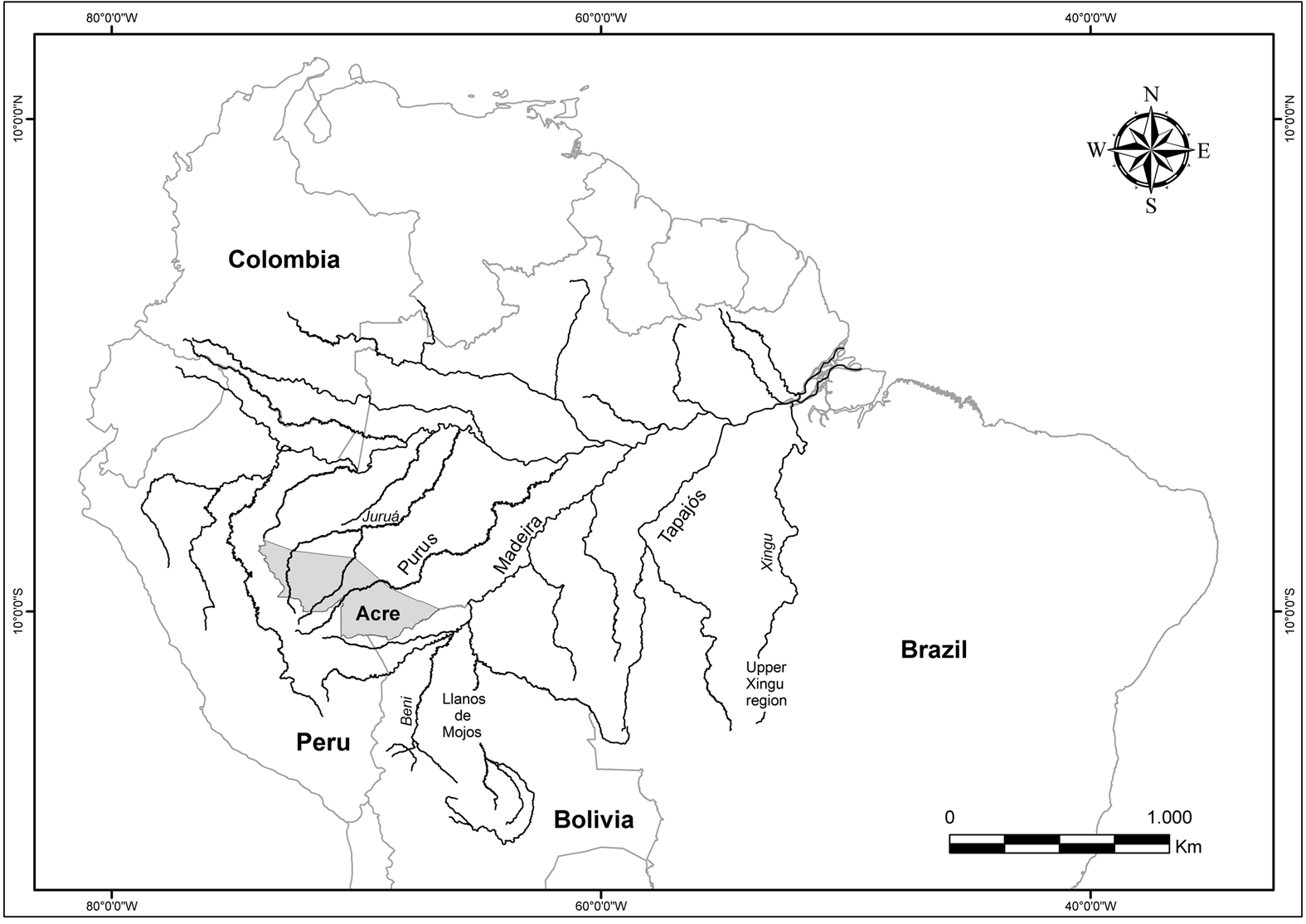
Figure 1. Location of the Acre state, Llanos de Mojos, Upper Xingu region, and major southern tributaries of the Amazon River mentioned in the text.
The archaeological evidence confirming such widespread interconnected networks of settlements and extensive earthworks has begun to shift our understanding of southern Amazonia before the time of the European conquest from that of a stagnated marginal backland to a historically dynamic and culturally diversified area. The centrality of the region is attested to not only by the presence of road networks and complex earthwork structures but also by the fact that it was a significant location for early ceramic traditions (Pugliese et al. Reference Pugliese, Zimpel, Neves and Smith2019) and plant domestication (Carson et al. Reference Carson, Watling, Mayle, Whitney, Iriarte, Prümers and Soto2015; Clement et al. Reference Clement, Rodrigues, Alves-Pereira, Mühlen, De Cristo-Araújo, Moreira, Lins and Reis2016; Dickau et al. Reference Dickau, Bruno, Iriarte, Prümers, Betancourt, Holst and Mayle2012; Hilbert et al. Reference Hilbert, Neves, Pugliese, Whitney, Shock, Veasey, Zimpel and Iriarte2017; Watling et al. Reference Watling, Shock, Mongeló, Almeida, Kater, De Oliveira and Neves2018). The region under discussion here is commonly referred to as the Southern Amazonian Borderlands. These Southern Borderlands polities were characterized by regionally oriented sociopolitical organizations, dense sedentary populations, circular plaza villages, well-planned extensive networks of roads, and wide-ranging agricultural and defensive earthworks (Heckenberger Reference Heckenberger2005; Heckenberger et al. Reference Heckenberger, Russell, Fausto, Toney, Schimdt, Pereira, Franchetto and Kuikuro2008). The data presented here suggest that the Upper Purus region may have been part of this culture area, or sociohistorical network as Heckenberger (Reference Heckenberger2005) describes it, given the prominent, long-term variety of earthwork-building practice in eastern Acre and the similarity between the settlement clusters and radial road networks found in both areas.
Ethnography of Southern Amazonian Circular Plaza Villages and Road Systems
Although identifying and thoroughly documenting the ethnolinguistic identity of Acrean plaza village dwellers is beyond the scope of this article, ethnographic analogs can help us interpret better the material record of an archaeological culture and comprehend how people in the past could have engaged with it. Regional ethnographic examples emphasize the importance of roads and circular village plans among southern Amazonian peoples. The circular plaza village system interconnected by extensive road networks is considered typical of Arawakan groups (Heckenberger Reference Heckenberger, Hill and Santos-Granero2002). Among the contemporary Kuikuro, a Carib-speaking group of the Upper Xingu region, the circular central plaza of the village has a sacred significance in defining hierarchical distinctions between adult men, chiefs, and ancestors and in constituting a spatial representation between the upper and lower moieties of society (Heckenberger Reference Heckenberger2005).
A similar expression of rigid spatial arrangement is typical for many Macro-Gê groups of Central Brazil, considered politically equalitarian but having, in contrast, extremely complicated socioceremonial organizations evidenced both ethnographically (Ewart Reference Ewart2003; Maybury-Lewis Reference Maybury-Lewis1979; Nimuendajú Reference Nimuendajú1946, Reference Nimuendajú1983) and archaeologically (Wüst and Barreto Reference Wüst and Barreto1999). Ritual obligations, intended to uphold the dual organization of exogamous moieties in circular Bororo villages, were numerous and highly structured (Lévi-Strauss Reference Lévi-Strauss and Lévi-Strauss1963). The diachronic structure divided the community into two opposed, complementary moieties, which had reciprocal responsibilities and symmetrical rights. At the same time, the social structure of these villages was concentrically hierarchized, as manifested by the contradiction between the central (sacred), male-dominated plaza and the periphery (profane), formed by the encircling residential units managed by women. Furthermore, the entirety of the settlement structure formed by the circular central plaza and the straight radial roads setting out from it served as an important ritual scene, particularly throughout the ceremonial season (Nimuendajú Reference Nimuendajú1946, Reference Nimuendajú1983). The tradition of using the village roads for ritual displays and racing (primarily inter-moiety log racing) is still maintained.
Métraux (Reference Métraux1942:164) mentions that the Arawak-speaking Mojo of the Llanos de Mojos, as well as their eastern neighbors, the Paressi of the Tapajós headwaters, “were great road builders and connected their villages with broad, straight, and perfectly clean highways.” The Mojo were organized into a reticular system of relations linking small dispersed settlements. According to Renard-Casevitz (Reference Renard-Casevitz, Hill and Santos-Granero2002:140), “It was an intra-ethnic association open to a variety of partners, sometimes close neighbors, sometimes distant allies, located along the routes of commerce.” Killick (Reference Killick2009) has also noted the complexity of human relationships in southwestern Amazonia, based not only on kinship or ethnicity but also on ties of friendship, and describes how these versatile forms of interaction have contributed to the formation of different local and regional alliances and social networks, thus creating and maintaining intricate networks of movement. In summary, large-scale social formations based on the presence of a multiplicity of communities, interconnected in accordance with the different types of social organizations outlined earlier, have been critical to the production of local and regional identities across the southern Amazonian fringe.
Patterned Villagescapes of Eastern Acre
The interfluvial plateau, pertaining to the Amazonian western sedimentary upland (Sombroek 2000:Figure 1), which varies from undulating to flat and is marked by a web of numerous small headwater streams, is the main geomorphological element in our research area. The region's vegetation structure is characterized by patches of bamboo-dominated (Guadua sp.) forest (Silveira et al. Reference Silveira, Daly, Salimon, Wedt, Ferreira, Pereira, Passos, Daly and Silveira2008) and an abundance of Brazil nut (Bertholletia excelsa) stands (Mori and Prance Reference Mori and Prance1990). Recent research shows that human occupation in Acre associated with the geometric ditched enclosures promoted changes from bamboo-covered to palm-covered forests (Watling et al. Reference Watling, Iriarte, Mayle, Schaan, Pessenda, Loader, Street-Perrott, Dickau, Damasceno and Ranzi2017). Therefore, the mound site settlements were probably constructed in human-built environments, such as areas covered by secondary-growth forests.
Because approximately 50% of the lowland rainforest in eastern Acre has been logged, and many earthwork sites are located on deforested areas currently covered by pasture, it is possible to apply diverse remote-sensing techniques to discover archaeological sites and model anthropogenic terrain. Our previous fieldwork in the study area included the excavation of some plaza villages or mound sites (Neves et al. Reference Neves, Pugliese, Furquim, Zimpel and Gibertoni2016; Saunaluoma et al. Reference Saunaluoma, Pärssinen and Schaan2018); however, our recent, remotely sensed survey (see also Saunaluoma et al. Reference Saunaluoma, Anttiroiko and Moat2019) brought to light new evidence of the regional scale and connectivity of these settlements. We used satellite imagery for the initial spatial localization of sites and then pedestrian surveys for conclusive site identifications. To date, we have positively identified 18 mound sites in eastern Acre, of which we have excavated five (Figure 2).

Figure 2. The study area and registered plaza villages in eastern Acre. Sites that we have excavated are in capital letters.
We performed unmanned aerial vehicle (UAV) surveying and 3D modeling at eight plaza village sites, of which four were previously unknown, with a low-altitude image-based approach using a DJI Phantom 4 quadcopter and Pix4DCapture application for automated flight missions. Surveys were conducted over areas of approximately 300 × 300 m. At each site, we captured 150–400 near-nadir images, using 80% overlap double-grid missions (two sets of flight paths at right angles to each other) at an altitude of 60–70 m above ground level. In addition, circular missions were flown around the sites at a height of approximately 40 m to obtain oblique site overviews and to gather additional data under tree canopies. We used the UAV's built-in GPS to give approximate georeferencing, which has been shown to be sufficiently accurate for topographic surveys (Pérez et al. Reference Pérez, Gonçalves and Charro2019). Surveys took between 15 and 20 minutes, and each site was captured with one survey. The collected UAV data were processed to dense 3D point clouds and exported in LAS format for further analysis. For detailed visualization and analysis of different earthwork features, we produced hillshaded 3D elevation models, which allowed us to recognize prominent patterning in the site layouts (Figure 3). A central conclusion of our UAV survey is that the arrangements, shapes, and sizes of the mounds, in conjunction with the radial road structures, are repetitive and extremely similar in all cases.

Figure 3. Hillshaded elevation models of the UAV-surveyed plaza village sites. (a) Sobrevoo AC09; (b) Boa Esperança; (c) Novo 2; (d) Novo I; (e) Fazenda Indaia; (f) Sol do Iquiri; (g) Sol de Campinas; and (h) Montículos Plácido. All sites are oriented to the north and on the same scale.
A typical eastern Acre plaza village site features 15–25 mounds arranged around a flat circular or ellipse-shaped area covering approximately 2–3 ha. The mounds vary between 10–25 m in maximum basal length and can reach about 2.5 m in height. They normally have an elongated oval shape, with their major axis orientated outward of the enclosure of mounds, their edges being steeper toward the village center and gradually fading away toward the outside. Straight radial 3–6 m wide road structures leave the villages in different directions, with the main entrances usually situated along the axes of the ellipse-shaped plazas. The sites are located on slightly elevated, yet level, terrain at 140–215 m asl and are normally situated near springs or at the junction of two bodies of water. So far, these villages have been found within a restricted area east of the Iquiri River in an area covering approximately 3,600 km2 (Figure 2).
We were able to identify some intrasite details from our digital elevation models (Figure 3). For example, Sobrevoo AC09 comprises fewer mounds than the other sites and has two successive mound construction phases, evidenced by partially overlapping mound and road structures in the southeast. The elevation model also reveals that the site's main road in the northwest extends to the center of the village plaza, whereas at the other sites the areas enclosed by the mounds do not contain any prominent earthwork structures. At Boa Esperança only the pronounced main road runs through the plaza in the north–south direction without traces of other entryways. The Novo I site is covered with thick waist-high grass that, together with intense midday sunlight, concealed the site's topography and left only the 6 m wide northern and southern village entrances clearly visible at the time of our UAV survey. Still, the hillshade reveals the mounds on the north side of the site. Because landowners are often misinformed and think that the recognition of an archaeological site automatically means strict restrictions on private land use and a decrease in property value, precolonial earthworks are occasionally deliberately destroyed. This unfortunately happened at Sol de Campinas, where almost half of the site was bulldozed; consequently, the mounds and the village entryways are now lacking on the southern part of the site.
So far, the earliest archaeological evidence for Amazonian circular plaza villages comes from the Paredão phase sites spanning the time period from the seventh to the eleventh centuries and situated in the confluence of the Negro and Amazon Rivers (Moraes and Neves Reference Moraes, Neves and Smith2019; Neves Reference Neves, Silverman and Isbell2008). Our radiocarbon measurements show that the plaza village sites of eastern Acre date around cal AD 1300–1600 (Table 1). The 14C dates also indicate that these mound sites are more recent than the geometric ditched enclosures (geoglyphs), which are found in great numbers in the same area and are interpreted predominantly as ceremonial spaces (Saunaluoma and Schaan Reference Saunaluoma and Schaan2012; Virtanen and Saunaluoma Reference Virtanen and Saunaluoma2017). Interestingly, some of these geometric enclosures are located adjacent to the mound sites, such as the square-shaped ditches at the Fonte Boa and Fazenda Iquiri II sites, which raises a question about the connection between these two different types of earthworks. Investigations at the Fazenda Iquiri II site demonstrated that the geometric ditched enclosure's archaeological deposits are older than those found in the mounds (Saunaluoma et al. Reference Saunaluoma, Pärssinen and Schaan2018), and this seems to be a regular chronological pattern in the area. Even though the two different types of earthworks are located in the same place, their chronological and functional differences are well defined: whereas the geometric enclosures normally contain scattered cultural remains, such as caches of shattered pottery and sparse evidence of activity areas, the mound sites were clearly occupational units featuring domestic deposits—albeit the emergence and duration of these occupations are not yet clear.
Table 1. Radiocarbon Dates from the Coqueiral, Sol de Maio, Sol de Campinas, Fonte Boa, and Fazenda Iquiri II Plaza Village Sites.

Notes: The dates were calibrated with OxCal 4.2 program using the ShCal13 curve for the Southern Hemisphere. Unless mentioned otherwise, the dated samples were wood charcoal associated with the mounds’ ceramic-bearing contexts.
We interpret the mounds as residential units based on domestic artifactual findings recovered from the excavations (Neves et al. Reference Neves, Pugliese, Furquim, Zimpel and Gibertoni2016; Saunaluoma et al. Reference Saunaluoma, Pärssinen and Schaan2018)—even though well-defined features related to permanent dwelling houses, such as post mold structures, have not been registered to date. Ceramic deposits at the mound sites are concentrated within and outside of the mounds, but the flat central plazas, surrounded by the mounds, are devoid of archaeological findings. However, excavations uncovered intense midden layers behind the mounds, outside of the plaza, at the Sol de Campinas site. Most ceramics accumulated in the mounds are sherds of large undecorated vessels for domestic use, but a few pieces of finer incised pottery were also found. The main ceramic tempers are charcoal, grog, and caraipé (siliceous tree-bark [Licania sp.] ash). The incised ceramics and curious small pedestal bases excavated from different mound sites support the interpretation of a close affinity in material culture between these plaza villages (Figure 4). Various fragments of grinding stones and small polished stone axes, as well as laterite flakes, were also recovered. Samples for phytolith analysis were collected at the Sol de Maio and Fazenda Iquiri II sites from excavation contexts associated with food processing. The collected items included partial or entire ceramic vessels and grinding stone residues. Analysis of the obtained samples revealed that maize, squash, and palm fruits were processed and consumed locally (Watling et al. Reference Watling, Saunaluoma, Pärssinen and Schaan2015).

Figure 4. Examples of ceramic materials recovered from the mound sites: pedestal bases and incised potsherds from (a) Fazenda Iquiri II; (b, e) Coqueiral; (c, d) Sol de Maio; and (d) Sol de Campinas. Scale in millimeters.
Networks Inscribed in the Interfluves
We used remotely sensed imagery (high-resolution satellite and UAV images) to identify ancient road segments, many of which are obscured by modern land use. Roads associated with the mound sites are usually 3–6 m wide; the funnelled main village entryways are clearly observable in the present-day landscape (Figure 5). Preserved continuous road lengths, currently most perceptible at the villages’ immediate surroundings, are visible to a distance between 200 and 1,500 m from the sites. The archaeological curbed roads of the Upper Xingu region were formed by initial construction when the roads were first cleared and by maintenance activities in which growing vegetation was scraped to the sides and accumulated in linear mounds (Schmidt Reference Schmidt2012). Household and ceremonial refuse was also deposited on the growing mounds within and near settlements. Repeated movement, erosion, and, in some cases, maintenance formed linear depressions where roads ascended and descended slopes. We believe that the formation of Acrean roads was accomplished by comparable means and that this well-planned road network once covered not just eastern Acre but also extended along the whole Amazonian southern rim. Labre's (Reference Labre1889) narrative supports this hypothesis: in October 1887, together with a party of 35 people, he was able to walk about 200 km in 20 days in southwestern Amazonia following the paths and roads already opened into the upland forests and known to the Indigenous people who guided him.

Figure 5. The main entryways (indicated by arrows) of the Nossa Senhora Aparecida site.
The detailed illustrations shown in Figure 6 are based on information obtained from satellite imagery and explain the grading and arrangement of some archaeological roads in eastern Acre. Section A shows the roads associated with the Sol de Campinas and the Fonte Boa mound sites, situated 2.2 km apart. The 7 m wide main entranceway of Sol de Campinas, extending 400 m to the northeast, is still very prominent in the landscape, whereas the narrower western road crosses a rivulet 400 m from the site, continues some 300 m, and disappears into the terrain. The southwest road is cut by highway BR-364 and is almost totally destroyed. Nevertheless, an 800 m long stretch of this road is visible through Google Earth satellite imagery acquired in 2009, heading straight in the direction of Fonte Boa. The geoglyph at the Fonte Boa site has 10 m wide entrances in the northern and southern sides of the square-shaped enclosure. The roads related to the mounds in the site's southeast sector are more difficult to detect. The roads that lead to the west and south from the mounds are visualized poorly because of dense vegetation cover, but older satellite images reveal that these roads extended several hundred meters from the site. A narrow radial road leaving the mound sector's northern side transects the square enclosure, implying that the mounds were constructed subsequent to the geoglyph.
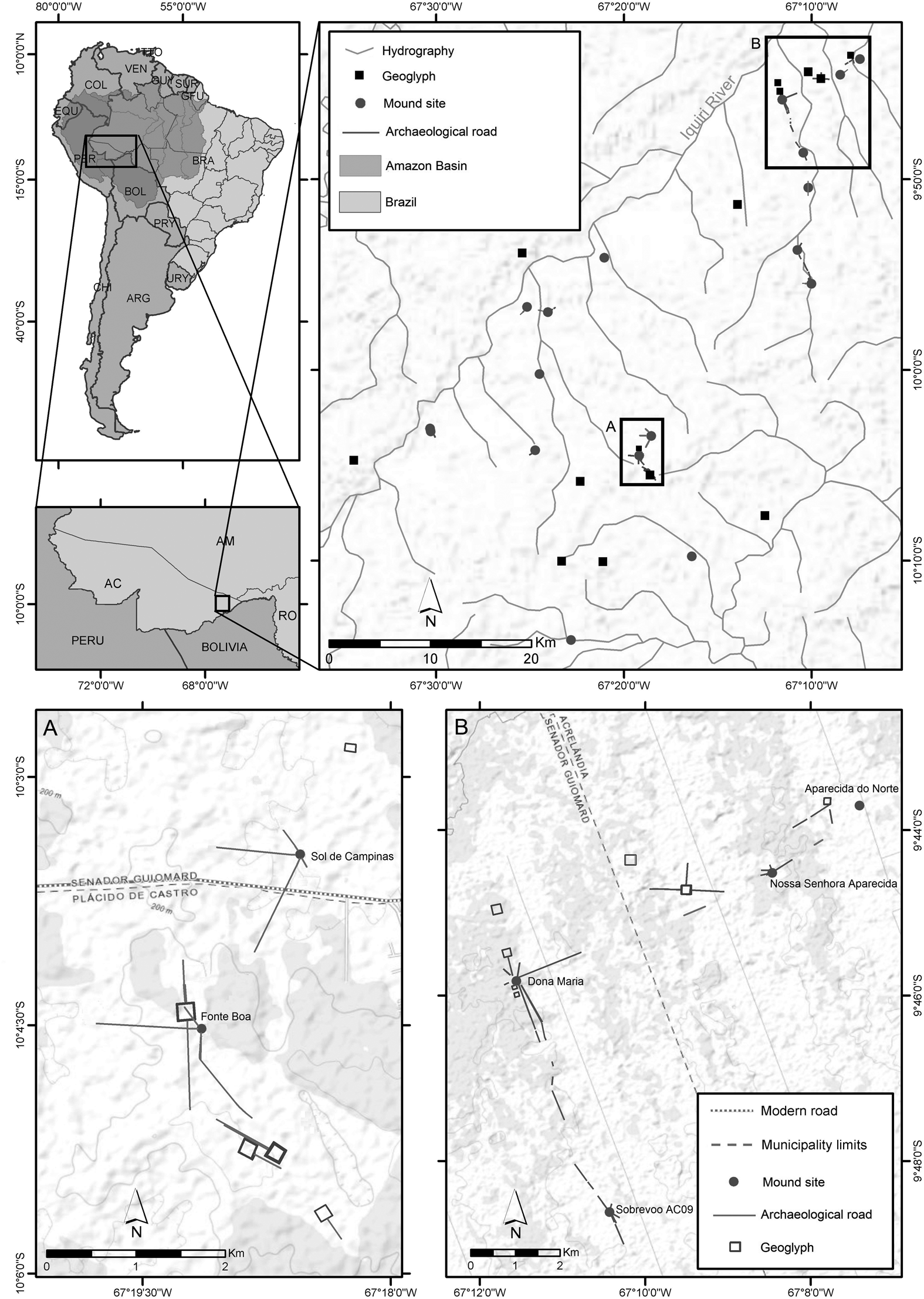
Figure 6. Roads associated with (a) Fonte Boa and Sol de Campinas, and (b) Sobrevoo AC09, Dona Maria, Nossa Senhora Aparecida, and Aparecida do Norte.
Section B in Figure 6 exemplifies the pattern of roads linking four plaza villages—Sobrevoo AC09, Dona Maria, Nossa Senhora Aparecida, and Aparecida do Norte—situated within a 10 km radius of each other. A square-shaped ditched enclosure (geoglyph), to date unregistered—measuring 190 × 190 m and featuring about 500 m long western, northern, and eastern entrance roads—is located between Dona Maria and Nossa Senhora Aparecida. The road connecting these villages passes by the geoglyph some 300 m to the south. Given the complexity of its earthworks, Dona Maria must have been an important node in the road network system presented here. In addition to a plaza enclosed by mounds, the site comprises six well-preserved road segments and four adjacent square-shaped geoglyphs. Several, still visible road segments between Dona Maria and Sobrevoo AC09, situated 5.5 km to the south, and Nossa Senhora Aparecida, 6 km to the northeast, convincingly attest that these sites were closely interrelated. The terrestrial connection between Nossa Senhora Aparecida and Aparecida do Norte is also obvious, as indicated by the preserved road segments. As mentioned earlier, our elevation model shows evidence of partially overlapping mound and road structures at the Sobrevoo AC09 site (Figure 3), implying that all radial roads were not necessarily contemporaneous. Nevertheless, it appears that generally the villages had two to three main entryways, with the addition of variable numbers of minor side roads.
The plaza villages’ primary roads served as linkages between the settlements, merging them into one regional unity. We surmise that the road network was built essentially for sociocultural interactions and was not solely intended for human movement, as attested by the outstanding patterning of village layouts and the similarity of material culture found at these sites. Less prominent roads leave the sites and run toward watercourses and other resource-rich areas, interconnecting the villages with the surrounding interfluvial environment. Yet, other road types exist in eastern Acre, associated with the geoglyph sites that in our study area comprise mainly square-shaped ditched enclosures (Figure 6). We believe that the roads linked to the geoglyphs of Acre were probably incorporated into the sites’ architecture as ceremonial pathways (Saunaluoma Reference Saunaluoma2012; Virtanen and Saunaluoma Reference Virtanen and Saunaluoma2017).
Conclusion
Our research revealed extremely well-defined patterning of late precolonial villages in eastern Acre, similar across this area in terms of size, outline, chronology, and material culture. These findings attest to the existence of sedentary interfluvial populations sharing the same sociocultural identity (or identities), as materialized in the village layout and the ceramic assemblages found at the sites. The evidence is clear also for structured patterns of movement and spatial planning in relation to operative road network systems. The relationship between the roads and the mound sites is clear and coherent across the various sites: the radial roadways form an indispensable part of the patterned villagescapes of eastern Acre. A common material culture and a similar settlement organization supported the sense of belonging to a place and to a community locally, as well as regionally. As for the latter, plaza villages may have also been regionally interconnected by the road networks, thereby forming a wide-ranging, culturally affiliated entity. The planning of the village networks took into account such factors as desired elements of the terrain, vegetation cover, and bodies of water; neighboring settlements; and other important places, such as ceremonial spaces comprising square-shaped ditched enclosures—creating a true archaeological meshwork intertwining the roads, the plaza villagers, and the interfluvial environment (see Ingold Reference Ingold2007). In addition to the roads, the natural topography also seems to some extent to have organized the region's human activities and movement within the landscape. For example, the Iquiri River appears to have formed a significant barrier to close social interaction, because all plaza villages identified up to now are located on the river's eastern side.
Taking into consideration the ethnohistorical and ethnographic evidence cited in this article, the presence of a long-term earthworking tradition, and indications of ancient road structures along the uplands of Amazonian southern margin (e.g., Denevan Reference Denevan1966; Erickson Reference Erickson, Erickson and Balée2006, Reference Erickson, Snead, Erickson and Darling2009; Heckenberger et al. Reference Heckenberger, Russell, Fausto, Toney, Schimdt, Pereira, Franchetto and Kuikuro2008; Souza et al. Reference Souza, Schaan, Robinson, Barbosa, Aragão, Marimon, Marimon, da Silva, Khan, Nakahara and Iriarte2018), we hypothesize that the plaza villages of Acre may have been connected by an interregional road network to neighboring territories—to Bolivian Llanos de Mojos and other southern Amazonian archaeological regions (e.g., the Upper Xingu Basin). The existence of such an expansive road network in the Amazon Basin contradicts the traditional view of the South American Tropical Lowlands as an isolated and marginal territory in which only the areas surrounding the main rivers sustained sedentary populations, with the rivers being the main routes for population movement and social interaction.
In Acre, the archaeological evidence of villages interconnected by road networks supports the view presented here that terrestrial movement along the networks of roads was the primary mode of human transport in the interfluvial headwater basin regions of southern Amazonia. Indeed, additional wide-ranging remotely sensed studies may reveal that this was the case throughout the uplands of the Amazon Basin. In short, even though the southern Amazonian road networks may occasionally appear as simple, unstructured trails, it does not mean that they were less designed or less systematic in their extent, intention, and functionality than the other South American ancient road systems, including the iconic Inca Road, the Qhapaq Ñan.
Acknowledgments
We are thankful to four anonymous reviewers for their useful comments on an earlier version of this article. Eduardo Neves thanks the Lemann Brazil Research Fund at Harvard University for a grant in support of the archaeological research and field school at the Sol de Campinas site in 2018. We thank Sadie Weber, Tiago Hermenegildo, Steve Bachman, Marcus Vinicio Neves d'Oliveira, and the field school students from Harvard University and Federal University of Acre for their contribution to the fieldwork at Sol de Campinas and Fonte Boa; Thiago Genoveze for organizing the logistics in São Paulo and Rio Branco; Eliude Rafael dos Santos and Vilma Rodrigues dos Santos for hosting us during our stay at the field school; the State Government of Acre for logistical support; and Jorge Mardini, head of the Acre branch of the Instituto do Patrimônio Histórico e Artístico Nacional (IPHAN). We are grateful to Thomas Meagher and Jean Ometto for bringing the majority of the team together at the Newton Fund LATAM Researcher Links Workshop, which was funded by the British Council (São Paulo) with matching funds from FAPESP.
Data Availability Statement
The data related to the publication are stored in the Seafile storage server of the University of Turku and are available from the corresponding author upon request.


