INTRODUCTION
Radiocarbon dating of the topmost horizon of soils buried under terrace fills has been widely used to obtain absolute dates for the construction of ancient agrarian terraces (Ballesteros et al. Reference Ballesteros, Andrade Cernadas and Criado Boado2006; Harfouche Reference Harfouche2006; Kemp et al. Reference Kemp, Branch, Silva, Meddens, Williams, Kendall and Vivanco2006; Puy and Balbo Reference Puy and Balbo2013; Quirós Castillo et al. Reference Quirós Castillo, Nicosia, Polo-Díaz and Ruiz del Árbol2013). Whether performed on charred material or on a specific fraction of organic matter (e.g. bulk, humic acid, or humin), the date obtained is assumed to reflect the latest organic inputs to the soil previous to its burying under the terrace fill (Matthews Reference Matthews1980; Hetier et al. Reference Hetier, Guillet, Brousse, Delibrajs and Maury1983; Matthews and Dresser Reference Matthews and Dresser1983). The consistency of this assumption depends on the absence of (1) external carbon inputs to the soil after its burial, (2) mobile organics through the buried soil profile (microrootlets, humic acids, microparticles), (3) erosion or disturbance of the A horizon during or after burial, and (4) older carbon from the soil organic system being included in the dated sample (Matthews Reference Matthews1980; Gilet-Blein et al. Reference Gilet-Blein, Marien and Evin1980; Geyh et al. Reference Geyh, Roeschmann, Wijmstra and Middeldorp1983; Hetier et al. Reference Hetier, Guillet, Brousse, Delibrajs and Maury1983; Martin and Johnson Reference Martin and Johnson1995; Holliday Reference Holliday2004). Contamination or alteration of the buried soil by any of these factors may lead to significantly younger or older dates than the actual age of the terrace. Despite being extremely critical for the reliability of the chronologies for terrace construction, the aforementioned caveats are not always systematically discussed when reporting 14C dates from buried soils under agrarian terraces (e.g. Ballesteros et al. Reference Ballesteros, Andrade Cernadas and Criado Boado2006; Branch et al. Reference Branch, Kemp, Silva, Meddens, Williams, Kendall and Pomacanchari2007; Bevan et al. Reference Bevan, Conolly, Colledge, Frederick, Palmer, Siddall and Stellatou2012; Puy and Balbo Reference Puy and Balbo2013; Quirós Castillo et al. Reference Quirós Castillo, Nicosia, Polo-Díaz and Ruiz del Árbol2013).
This article presents 14 14C dates obtained from the charred material (11) and the bulk organic fraction (3) embedded in soils buried under four Andalusi irrigated terraces in Ricote (SE Spain). In order to evaluate the reliability of the obtained dates for terrace construction, we assess the integrity of the Ab horizons and their degree of mixing with the overlying terrace fills through bulk analyses [particle size distribution (PSD), total organic carbon (TOC), CaCO3, magnetic susceptibility (Mag Sus)] and statistics. Previous research on soils and buried soils (Tite and Mullins Reference Tite and Mullins1971; Fine et al. Reference Fine, Singer and Verosub1992; Heller and Evans Reference Heller and Evans1995; Goldberg and Macphail Reference Goldberg and Macphail2006; Branch et al. Reference Branch, Kemp, Silva, Meddens, Williams, Kendall and Pomacanchari2007; Bal et al. Reference Bal, Rendu, Ruas and Campmajo2010; Bevan et al. Reference Bevan, Conolly, Colledge, Frederick, Palmer, Siddall and Stellatou2012) has shown that pedogenesis, colluvial processes, and organic inputs from fauna and plants previous to burial define buried soils in terms of texture, carbon content, and magnetic minerals, allowing their differentiation from overlying deposits. Our hypothesis is that there is a significantly different multivariate effect of these three variables in soils and sediments. This difference can be quantified through calculation of the effect size (Nakagawa and Cuthill Reference Nakagawa and Cuthill2007). Postdepositional and taphonomical processes after terrace construction, however, may blur these differences and homogenize the stratigraphy (Balek Reference Balek2002; Canti Reference Canti2003; Holliday Reference Holliday2004; Goldberg and Macphail Reference Goldberg and Macphail2006). These can be statistically formalized, with the null hypothesis (Ho) being “the buried soils and the terrace fills immediately topping them are not significantly (p>0.05) different,” and the alternative hypothesis (Ha) being “the buried soils and the terrace fills immediately overlying them are significantly (p<0.05) different.” Rejection of Ho in favor of Ha can thus be interpreted as evidence for ruling out mixing between the Ab horizons and the overlying terrace fills.
Andalusi irrigated-terraced fields (Iberian Peninsula, AD 711–1492) were the first acclimation areas of oriental plants (e.g. lemon and orange tree, artichoke, watermelon, sugar cane, cucumber, Colocasia) in the western Mediterranean (Watson Reference Watson1983; Glick Reference Glick1991; Retamero Reference Retamero1998). Most of them are still in operation to date, allowing farmers to grow fruits and vegetables that are exported all over Europe. In spite of a long tradition of historical research on Andalusi irrigated-terraced fields (Barceló et al. Reference Barceló, Kirchner and Navarro1995, Reference Barceló, Kirchner, Martí and Torres1998; Kirchner Reference Kirchner1997, Reference Kirchner1998; Barceló and Retamero Reference Barceló and Retamero2005; Sitjes Reference Sitjes2006; Torró Reference Torró2007; Guinot and Esquilache Reference Guinot and Esquilache2012; Puy Reference Puy2014), the time of their construction is still loosely defined. Andalusi written records are scarce and mentions to agrarian areas before the 10th century AD are virtually nonexistent (Guichard Reference Guichard2001). Archaeological excavations for the al-Andalus period have mostly focused on urban sites, domestic areas, and fortifications, overlooking the excavation and dating of agrarian fields (Kirchner Reference Kirchner2011). So far, the only attempt to 14C date the construction of an Andalusi irrigated-terraced area has been that of Puy and Balbo (Reference Puy and Balbo2013), which obtained a single date of cal AD 647–778 (2σ) from an A horizon buried under a terrace fill in Ricote, SE Spain. The present paper also reassesses this result.
Detailed information on the physiography, history, and archaeology of Ricote and its irrigated area has been extensively published (Puy Reference Puy2012, Reference Puy2014; Puy and Balbo Reference Puy and Balbo2013). Located in the region of Murcia, Ricote is the main village of the Ricote Valley (Figure 1). The climate is semiarid with strong seasonality. The mountain ranges are essentially limestone and Keuper marls, the soils being mostly Regosols, Calcisols, and Leptosols (FAO 2006). The irrigated-terraced fields, which are the most conspicuous feature of the village, receive water from a perennial spring located in the southwesternmost part of the irrigated area. They extend over 120 ha in a hoya, a flat basin probably of karstic origin, surrounded by mountains. Previous research by Puy (Reference Puy2012, Reference Puy2014) and Puy and Balbo (Reference Puy and Balbo2013) identified (1) the location of the first Andalusi irrigated terraces by means of the method known as hydraulic archaeology (Kirchner and Navarro Reference Kirchner and Navarro1993), which relies on archaeological survey and the study of written records, (2) their construction process, and (3) the evolution of the hydraulic system through time. The first Andalusi irrigated-terraced cluster, which was originally formed by four terraces extending over 1.9 ha, was constructed using local soils after clearing the terrain of vegetation with fire. Several enlargements carried out in later periods extended the hydraulic system to its current dimensions, which were fully reached by AD 1613. Regarding history and archaeology, three Andalusi settlements have been found in three different hills around the hoya: one in Algezar (surface pottery sherds dating from the 11th–13th centuries AD); one in Rife (surface pottery sherds dating from the 9th–13th centuries AD), and the last one in a fortification northeast of the Ricote village, already established by AD 896 (Figure 1).

Figure 1 Topographical map showing the Andalusi irrigated-terraced cluster identified by Puy (Reference Puy2012, Reference Puy2014) and the location of the trenches (T1–T4) (map provided by José Gabriel Gómez Carrasco). The inset shows the location of Ricote in modern SE Spain.
With this paper, we thus aim to (1) provide a statistical framework for the appraisal of the preservation of buried soils under terrace fills and (2) show the potential of this framework in the case of Ricote, aiming at assessing whether the 14C ages obtained from Ab horizons reliably reflect the foundation of the first Andalusi irrigated terraces.
MATERIALS AND METHODS
Sampling
We used a mechanical digger to excavate the four terraces (T) identified by Puy (Reference Puy2012, Reference Puy2014) as being the first cluster of Andalusi origin (Figure 1). The trenches were dug perpendicularly to the supporting walls in uncultivated patches of terrain. The depth was chosen to reach the B horizon of the original slope soil before terrace construction to fully expose Ab horizons (Puy and Balbo Reference Puy and Balbo2013). The resulting soil profiles were cleaned, drawn, and described following Hodgson (Reference Hodgson1976).
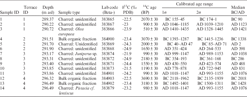
Fourteen discrete soil samples (~500g each) were collected from Ab horizons in order to 14C date the first construction of the terraces. We decided to sample both the upper and the bottommost part of each Ab horizon, as our aims were to assess the degree of mixing between Ab horizons and terrace fills and the disturbance within each Ab horizon before terrace construction. The location of the sampling for accelerator mass spectrometry (AMS) analysis was decided after inspection of the buried soil profiles. Whenever visible (such as for samples 3, 1, 11, 9, 7, and 14), we directly sampled charcoal fragments and the surrounding sediment. For those sections that did not show any visible charcoal, we sampled areas that seemed to be preserved from contamination with younger carbon—without apparent channels cutting both terrace fills and Ab horizons, signs of mixing, etc. Whenever possible, we prioritized collecting AMS samples following vertical transects from bottom to top. The stratigraphic profiles were also sampled at 5-cm intervals (T1, n=44; T2, n=36; T3, n=49; T4, n=24) (Figures 2, 3).

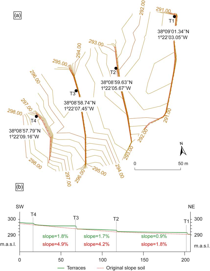
Figure 2 Topography of the Andalusi irrigated terrace cluster: (a) plan showing the location of the trenches (T); (b) section of the excavated terraces.

Figure 3 Stratigraphy of the excavated terraces. The gray color shows the different Ab horizons found below the terrace fills. The black dots show the location of the charred samples collected for 14C dating. The black stars show the position of the samples dated by means of the bulk organic fraction. Dates are 14C ages.
Field Description and Soil Macromorphology
The excavated terraces extend over 0.7 ha (T1), 0.6 ha (T2), 0.5 ha (T3), and 0.1 ha (T4), the lowest and highest elevation being 291.47 m asl (T1) and 297.49 m asl (T4), respectively. Ab horizons were located at 110 cm (T1), 105 cm (T2), 180 cm (T3), and 95 cm (T4) below the current surface of the terraces, whose slope ranged between 0.9% (T1) and 1.8% (T3). The buried soils had a slope ranging between 1.8% (T1) and 4.9% (T3), indicating that the steepness of the slope was reduced by more than half with the construction of the terraces (Figure 2).
The terrace fills of T2, T3, and T4 were massive and consisted of redistributed soil material with few subrounded and subangular clasts and root channels. However, T1 showed a 10-cm-thick 2Apb horizon located 68cm below the current cropping surface, formed by 20–25% concentration of evenly distributed subrounded centimetric charcoal fragments. No reddening or ashes were found in the groundmass of horizon 2Apb, although it did show a considerable concentration of undiagnostic pottery sherds less than 20cm in size in the rightmost part of the profile. Evidence of burning, charcoal, and significant concentrations of pottery was restricted to horizon 2Apb in T1. The rest of the terrace profiles seldom showed fragments of undiagnostic pottery sherds, mostly under 0.5cm in size, randomly distributed within the terrace fills.
The Munsell color of the terrace fills ranged from gray, light brownish gray to light yellowish brown. Those of the Ab horizons were darker, ranging from dark gray to very dark gray. The boundary between the Ab horizons and the terrace fills was sharp in T4, gradual in T1 and T3, and diffuse in T2. The thickness of the Ab horizons was 35 cm (T1), 55 cm (T2), 55 cm (T3), and 25 cm (T4). Except the buried soil in T3, which sloped eastwards towards a vertical alignment of angular and subangular clasts 60 cm thick, the rest were found to be mainly even, continuous, and parallel to the current surface of the terraces. No signs of plowing or hoeing were observed in any of the Ab horizons.
Buried soils in T2, T3, and T4 were defined in the field as Calcisols (Ab-Bkb), the main macromorphological features being 5–10% of CaCO3 and gypsum rounded and subrounded nodules with sharp boundaries less than 0.6 cm in size, as well as 2–5% of CaCO3 permanent filaments (pseudomycellia) and calcified rootlets. The buried soil in T1 was defined as a Planosol with a stagnic B horizon (2Ab-2Bgb), showing a sharp increase in the clay fraction from 10% in the surface horizon to 15–25% in the subsoil. Moreover, 15–40% very fine green and red-colored distinct mottles were found evenly spread along the 2Bgb horizon, which topped two colluvial subhorizontal sheets formed of subrounded and subangular stones less than 2 cm in size. All four Ab horizons presented weakly to moderately developed pedality, with fine to medium subangular blocky peds and few to very few subrounded and subangular small to medium-sized stones, decreasing in size and quantity with depth. All Ab horizons contained a few snail shells and channels.
Soil Analyses
The analyses were carried out on the fraction <2000 µm after air-drying the samples for 24 hr at room temperature. Carbon analyses were performed with a Vario EL Cube® C-analyzer. Total carbon (TC) was determined on 20-mg powdered samples. TOC was calculated on 15-mg samples after removing carbonates with 10% HCl solution and subtracting the obtained C values to those of TC. Total inorganic carbon (TIC) was calculated as TC–TOC and CaCO3 values as TIC×8.33.
PSD was performed on a Beckman Coulter LS13 320 after removing the carbonates and the organic matter with solutions of 10–15% HCl and 15% of H2O2, respectively. Statistical calculations and the description of the grain size distribution followed Folk and Ward (Reference Folk and Ward1957) and were done using Gradistat 8.0 (Blott and Pye Reference Blott and Pye2001).
Mag Sus was calculated on 10-cm3 whole sediment samples with a Kappabridge KLY-2= (Geofyzica Brno) and a field of 0.1 mT at a frequency of 470 Hz. Units were corrected by mass and presented as cgs (cm3/g).
Data Analyses
Standard statistical analyses were performed with XLStat Pro® version 2015.1, while effect size (f, f 2) post hoc tests were carried out with G*Power version 3.1.9.2 (Faul et al. Reference Faul, Erdfelder, Buchner and Lang2009). All p values were set at 0.05.
In the first step, three Welch’s analysis of variance (ANOVA) were run to determine whether there were significant differences in the mean of the main grain size fractions (sand, silt, clay), carbon contents (TOC, CaCO3), and magnetic susceptibility (Mag Sus) values between (1) Ab horizons of T1 (n=7), T2 (n=11), T3 (n=11), and T4 (n=5); (2) terrace fills of T1 (n=10), T2 (n=10), T3 (n=10), and T4 (n=10); and (3) Ab horizons (n=34) and terrace fills (n=40). For the terrace fill independent groups, only the first 10 samples (50cm) immediately topping the buried soils were considered, as the current Ap horizons may have physical properties distinct from the rest of the terrace tread due to ongoing cropping and soil tillage (Lobb Reference Lobb2009). Including the topmost 40–50cm of the terrace fill in the analyses risked rejecting the null hypothesis even in case of mixing between the Ab horizons and the overlying deposits, thus leading to a Type I error or false positive.
We first tested the assumptions for the ANOVA. Outliers were identified by means of boxplots as values falling more than 1.5 box lengths from the lower or upper hinges, and were replaced by the value of the next most extreme value. Shapiro-Wilk tests were conducted afterwards to check whether the dependent variables were normally distributed in each independent group. Statistically significant results for the Welch’s ANOVA were followed up with Games-Howell post hoc tests in order to determine precisely which groups differed.
In the second step, a multivariate analysis of variance (MANOVA, Wilk’s lambda) was selected as a multivariate test to check whether there were differences between the means of the Ab horizons and the overlying terrace fills on a combination of dependent variables, thus directly testing the null hypothesis (Ho: “the buried soils and the terrace fills immediately overlying them are not significantly different”). Since soils and sediments cannot be defined by a single property, the different variables that characterize them are more meaningful taken together than considered separately. The dependent variables accounted for the MANOVA were the sand fraction, TOC, and Mag Sus. Exclusion of the remaining grain or carbon fractions aimed at avoiding multicolinearity, a potential issue for the MANOVA when dealing with dependent variables that are weighted averages of the others. We considered the combination of sand (2000–65 µm), TOC, and Mag Sus to be a good proxy for the assessment of the degree of mixing between the terrace fills and the Ab horizons from where the dated organic material (1000–500 µm) was collected. Performing the equations with silt/clay or the rest of the carbon fractions risked getting a Type II error or false negative, since continuous percolation of fine material and carbonates along profiles due to irrigation might have homogenized Ab horizons and terrace fills that were not mixed after terrace construction.
We then checked the assumptions for the MANOVA. The normality assumption and the existence of outliers were checked and corrected following the same procedures used for the Welch’s ANOVA. Multicolinearity and linear relationships between each pair of dependent variables for each independent variable were respectively assessed through variation inflation factors (VIF) and scatter plots. The existence of multivariate outliers was assessed with a Cook’s D test at a critical value of 4/(n–k–1), where n is the number of samples and k is the number of explanatory variables (Dattalo Reference Dattalo2013). The assumption of similar variances and covariances was respectively checked through Levene’s and Box’s tests of equality. Statistically significant results were also followed up with a Welch’s ANOVA.
14C Dating
Samples collected for 14C dating were stored in dry conditions and dry-sieved through 2000-, 1000-, and 500-µm meshes. The different size fractions were observed under a binocular lens to collect the charred material from the sediment. With the exception of sample 3 (3 mg), all samples contained less than 2 mg of charred material. Identification was only possible for samples 3 (Olea europaea), 7 (Juniperus sp.), and 14 (Pistacia cf. lentiscus) due to the bad preservation of the charcoals and their submillimetric size (mostly between 100–500µm). Since no datable macrofossils were found in samples 4, 12, and 13, the bulk organic fraction was dated after removing the carbonates.
The other 14C dates were obtained on charred material. For samples 3, 7, and 14, we dated single charcoal particles. For the rest, we dated a mixed sample of all charred fragments found in one sediment sample after sieving the sediment. Beta Analytic (Miami, Florida, USA) carried out the pretreatment and the dating of the 14 samples. OxCal v 4.2 (Bronk Ramsey Reference Bronk Ramsey2009) and the IntCal13 calibration curve (Reimer et al. Reference Reimer, Bard, Bayliss, Beck, Blackwell, Bronk Ramsey, Caitlin, Hai, Edwards, Friedrich, Grootes, Guilderson, Haflidason, Hajdas, Hatté, Heaton, Hoffmann, Hogg, Hughen, Kaiser, Kromer, Manning, Niu, Reimer, Richards, Marian Scott, Southon, Staff, Turney and van der Plicht2013) were used for calibration.
RESULTS
Soil Analyses and Statistics
Figure 4 displays the results of the soil analyses. The mean and the distribution of scores for the Ab horizon and the terrace fill in each terrace varied considerably for most of the dependent variables, which suggests that (1) Ab horizons and terrace fills of T1–T4 were highly heterogeneous in terms of physicochemical properties, and (2) Ab horizons were likely not fully mixed with overlying terrace fills.

Figure 4 Boxplots (untransformed data without outliers) showing the scores for each dependent variable.
We explored the first inference by means of the Welch’s ANOVA with the Games-Howell post hoc tests. After transforming the data sets, the normality assumption was still being violated (p>0.05) by 10% of the dependent variables in the Ab horizon groups, by 3.57% of the dependent variables in the terrace fill groups, and by 57.14% of the dependent variables for the comparison between Ab horizons and terrace fills. Since the one-way ANOVA is fairly robust against deviations from normality (McDonald Reference McDonald2014), we performed the tests anyway. The results are shown in Figure 5 and indicate the following:
-
∙ There were significant differences between the four Ab horizons in all the dependent variables. Silt and CaCO3 had the largest effect size (f).
-
∙ There were significant differences between the four terrace fills in all the dependent variables. Sand, silt, and clay had the largest effect size (f).
-
∙ There were significant differences between the Ab horizons and the terrace fills in their Mag Sus values and TOC contents, which respectively had a large and a moderate effect size following Cohen’s (Reference Cohen1988) classification.

Figure 5 Bar charts plotting the results of the Welch’s ANOVA and the effect size (f) tests for the comparison between the least-square (LS) means of Ab horizons, between the LS means of terrace fills, and between the LS means of Ab horizons and terrace fills. The x axis terrace numbers or soil layers with the same symbol are not significantly different (Games-Howell post hoc test).
The second inference was explored by means of the MANOVA. The assumption of no multicolinearity was fulfilled, as tolerance values and VIFs for all dependent variables were <10 and >1, respectively (Williams Reference Williams2015). The following assumptions were not fulfilled:
-
∙ The requirement for similar covariances (Box’s test) was violated in T3. However, since the sample sizes in T3 were highly balanced (n=11 for the Ab horizon, n=10 for the terrace fill), we considered this violation acceptable.
-
∙ The requirement for no multivariate outliers (Cook’s D test) was violated by four samples in the Ab horizon groups (T1=1, T3=2, T4=1) and two samples in the terrace fill groups (T1=1, T2=1). We decided to keep the multivariate outliers anyway, as further tests revealed that they were not correctable.
-
∙ The requirement for similar variances (Levene’s test), which was violated by the sand dependent variable in T1 and the TOC dependent variable in T2–T3. This forced acceptance of a lower level of significance (α) for the Wilk’s lambda test.
The results for the MANOVA are summarized in Table 1. All p values obtained (p<0.021) were much lower than the alpha level (0.05). Based on Cohen’s (Reference Cohen1988) classification, the effect size (f 2 ) for T1, T3, and T4 was defined as “large” and “very large,” while that for T2 was defined as “medium.” The percentage of nonoverlap in the distribution of scores for the Ab horizon and the terrace fill on the combination of the selected variables was thus 77.4–79.4% in T1, 51.6–55.4% in T2, 75.4–77.4% in T3, and higher than 81.1% in T4. These results indicate that the magnitude of difference between Ab horizons and terrace fills was high for T1, T3, and T4 and moderate for T2. On these grounds, we rejected the null hypothesis (Ho) for all four terraces.
Table 1 Results of the MANOVA and effect size (f 2 ) tests. Bold p values are statistically significant.

The following data are presented as mean±standard deviation. The followup Welch’s ANOVA indicated that the dependent variable with the highest effect on the independent groups was Mag Sus, whose values in Ab horizons and terrace fills (TF) were significantly different for all the terraces:
-
∙ T1: Ab=78.865±13.330, TF=183.377±32.823, p=0.000, f=0.871.
-
∙ T2: Ab=115.273±15.641, TF=135.845±25.062, p=0.042, f=0.452.
-
∙ T3: Ab=71.204±24.318, TF=140.871±17.367; p=0.000, f=0.923.
-
∙ T4: Ab=80.059±3.881, TF=116.285±9.853; p=0.000, f=0.751.
The sand and TOC dependent variables had a smaller effect, with the former showing significantly different values between the Ab horizon and the terrace fill-in:
-
∙ T4: Ab=28.453±2.883, TF=14.704±6.539, p=0.000, f=0.749.
and the latter between the Ab horizon and the terrace fill-in:
-
∙ T2: Ab=0.796±0.046, TF=0.863±0.066, p=0.013, f=0.205.
14C Dating
14C dates obtained from the buried soils are shown in Table 2. The age of the samples was correlated with depth in every excavated terrace. The bulk organic fraction provided significantly older median dates than the charred material [Welch’s ANOVA, F(1, 6)=60.766, p=0.000, f=0.821]. Sample 13 (bulk organic, 1500–1311 cal BC, 2σ), for instance, yielded a date ~2500 yr older than sample 14 (Pistacia cf. lentiscus, cal AD 994–1154, 2σ), despite being collected from the topmost horizon of the same buried soil. Overall, the latest age of the charred material contained in the topmost horizon of the four buried soils clustered around the 10th–13th centuries AD. The median ages of the unidentified charred material were also significantly older than those provided by the identified charred material [Welch’s ANOVA, F(1, 7)=9.663, p=0.017, f=0.591]. No outliers (values falling more than 1.5 box lengths from the lower or upper hinges of a boxplot) were found on the ages yielded by the charred material. The youngest age was yielded by sample 3 (cal AD 1328–1445, 2σ), collected from horizon 2Apb in T1.
Table 2 Summary of 14C dates.

DISCUSSION
Differences between Dates from Bulk Organic Fraction and Charred Material
The dating of a specific organic matter fraction (bulk, humic, humin) allows 14C dating of buried soils lacking in charred material or organic macroremains. Which fraction is most convenient depends on soil type and vegetation as well as on the target of the dating. Martin and Johnson (Reference Martin and Johnson1995) pointed out that the humic fraction works better for dating the burial of Holocene soils, as it generally provides the youngest age. Dating of the humic fraction has indeed yielded accurate results for Andosols, both current and buried under Medieval terrace fills (Tonneijck et al. Reference Tonneijck, van der Plicht, Jansen, Verstraten and Hooghiemstra2006; Ferro-Vázquez et al. Reference Ferro-Vázquez, Martínez-Cortizas, Nóvoa-Muñoz and Ballesteros-Arias2014). However, for irrigated terraces in semiarid environments, the combination of coarse material and percolating water may promote the downward translocation of humic acids from the current soil surface to the buried soil, thus making the date for terrace construction younger (Hammond et al. Reference Hammond, Goh and Tonkin1991; Martin and Johnson Reference Martin and Johnson1995; Holliday Reference Holliday2004). In Ricote, electrical tomography measurements (ERT) carried out in the plots showed that the water infiltrated ~120–150 cm below the cropping surface of the terraces 5 hr after irrigation (Daniel Blum, personal communication). The lack of a significant difference between the CaCO3 contents of Ab horizons and overlying terrace fills, as well as the presence of moderately to strongly impregnated typical CaCO3 nodules with sharp boundaries and pseudomycellia in all Ab horizons, indicates regular translocation and precipitation of carbonates from the terrace fills into the buried soils due to irrigation. This scenario suggests a possible contamination of the buried soils with humic acids leached from above. The insoluble humin fraction, on the other hand, may provide older dates for soil burial, since it is the most stable organic fraction and roughly represents the age of the soil (Becker-Heidmann et al. Reference Becker-Heidmann, Liang-Wu and Scharpenseel1988; Pessenda et al. Reference Pessenda, Gouveia and Aravena2001).
The bulk organic fraction consists of a mixture of different organic compounds with different ages and turnover rates, likely providing insight into the mean residence time (MRT) of the soil organic matter immediately before terracing (Matthews Reference Matthews1980; Hetier et al. Reference Hetier, Guillet, Brousse, Delibrajs and Maury1983; Matthews and Dresser Reference Matthews and Dresser1983). However, the dates yielded by the bulk organic fraction in Ricote were significantly older than those yielded by the charred material, suggesting that they did not reflect the latest organic inputs to the soil before terrace construction. In that sense, Eckmeier et al. (Reference Eckmeier, van der Borg, Tegtmeier, Schmidt and Gerlach2009) found that the microcharcoal fraction (<53µm) might contain the products of charcoal degradation and more stable components than macrocharcoal, thus yielding comparatively older 14C dates. This might be the case with the dates provided by the bulk organic fraction in Ricote (<125µm), which should therefore be interpreted as earliest ages for soil formation (Wang et al. Reference Wang, Amundson and Trumbore1996).
Preservation and Integrity of the Ab Horizons
Shallow and slowly buried soils are more prone to contamination with younger carbon infiltrating down from the sediment above (Martin and Johnson Reference Martin and Johnson1995). 14C dating of buried soils under check-dams or cross-channel terraces may be problematic due to their construction process, which involves the progressive accumulation of sediment behind the wall (Spencer and Hale Reference Spencer and Hale1961; Treacy and Denevan Reference Treacy and Denevan1994). The excavated terraces in Ricote were classified as cropping surfaces constructed by fill and sustained by stonewalls (Frederick and Krahtopoulou Reference Frederick and Krahtopoulou2000). The absence of stratification or bedding within the terrace fills in T2, T3, and T4 suggests that the original slope soils were topped at once with at least 1 m of sediment. The presence of horizon 2Apb in T1, however, indicates that a reconstruction of the terrace probably took place after cal AD 1328–1445 (2σ). We interpret horizon 2Apb in T1 as being the former cropping surface of the terrace, according to the evenly horizontal distribution of centimetric charcoal fragments of Olea europaea and the presence of pottery sherds. Thus, the original slope soil in T1 (3Ab) was probably located only 25 cm below the ground during at least 200 yr, with higher chances to be disturbed by soil tillage and cropping carried out on the former terrace surface.
In any case, the results of the Wilk’s lambda and the effect size tests indicate that there is a large magnitude of difference between the Ab horizons and the terrace fills of T1, T3, and T4 in their combination of sand, TOC, and magnetic mineral contents. More than 75% of the distribution of their scores after the Wilk’s lambda test did not overlap. The effect size for T2, although more moderate, indicated that between 51–55% of the distribution of the scores for the Ab horizon and the terrace fill did not overlap either. Moreover, the date yielded by horizon 3Ab in T1 (cal AD 1039–1210, 2σ) concurs with the latest dates obtained from Ab horizons in T3 (cal AD 989–1153, 2σ), and T4 (cal AD 993–1155, 2σ). This evidence suggests absence of mixing in all terraces and point towards a negligible contamination of horizon 3Ab in T1 with younger charred material translocated from above.
Older carbon may be brought to the soil surface from deeper horizons by erosion or bioturbation (Matthews Reference Matthews1980). Both processes disturb the soil and rearrange its structure. Research carried out by Sadiki et al. (Reference Sadiki, Faleh, Navas and Bouhlassa2007, Reference Sadiki, Faleh, Navas and Bouhlassa2009) has shown that stable, undisturbed soils tend to show a regular increase in Mag Sus values from deeper layers towards the surface, while those that have been mixed and disturbed usually present irregular and homogeneous values along the profile. Buried soils that have remained undisturbed also present a different magnetic mineralogy compared with the overlying sediments (Fine et al. Reference Fine, Singer and Verosub1992; Virina et al. Reference Virina, Faustov and Heller2000; Maher et al. Reference Maher, Mengyu, Roberts and Wintle2003; Balsam et al. Reference Balsam, Ji and Chen2004). Contrasting Mag Sus values between buried soils and topping deposits should be expected even if the latter had originally been the same underlying soil, since shifting rearranges the alignment of ferrimagnetic minerals. Ab horizons in Ricote showed both a regular increase in Mag Sus values from the bottom up, with the highest Mag Sus values on top (Figure 6), and a linear relationship between the age of the organic matter ands depth (Table 2), which is a typical feature of stable soils developed in warm, well-drained settings (Matthews Reference Matthews1985; Wang et al. Reference Wang, Amundson and Trumbore1996). Moreover, the results of the effect size test (f 2=0.675) indicated that 73.1–75.4% of the distribution of the Mag Sus scores for Ab horizons and terrace fills did not overlap. This evidence points towards a lack of relevant disturbance in the original slope soils before and after terrace construction.

Figure 6 Mag Sus values for the Ab horizons of T1–T4.
The Andalusi terraces in Ricote were constructed on top of highly different soils. T1 was likely built on a seasonally waterlogged terrain, while T2–T4 were built on carbonatic soils. The statistically significant differences and the large effect size found between the Ab horizons in their sand, silt, clay, TOC, CaCO3, and magnetic mineral contents (Figures 4, 5) suggest that the area selected for cropping was highly heterogeneous in terms of soil-forming processes despite its relatively reduced extent (1.9ha). This diversity probably required the farmers to implement different strategies in order to prepare the terrain before building up the terraces. Puy and Balbo (Reference Puy and Balbo2013) suggested the use of fire in Ricote as a land clearance strategy prior to constructing T3. The sloping of the Ab horizon in T3 towards a vertical alignment of stones suggests that it could have been a relict terrace surface. However, the physicochemical data available to date do not indicate that the Ab horizon in T3 is different from the rest of the buried soils in terms of their carbon contents or texture.
Regarding the Ab horizon in T1, drainage is needed in hydromorphic terrains to prevent landslides and protect the stability of the terrace cluster in case of heavy precipitations and mounding of the groundwater. Although we do not have evidence for drainage in T1, we know that Andalusi farmers drained seasonally waterlogged soils in other centers of al-Andalus, such as in Tortosa (NE Spain) or Pla de la Vila (Ibiza, Balearic Islands) (González Villaescusa and Kirchner Reference González Villaescusa and Kirchner1997; Puy et al. Reference Puy, Balbo, Virgili and Kirchner2014).
Construction of the Andalusi Irrigated-Terraced Cluster of Ricote
Many researchers have pointed out that farmers never construct isolated terraces, but terrace clusters (Ron Reference Ron1966; Niles Reference Niles1987; Barceló et al. Reference Barceló, Kirchner, Martí and Torres1998; Torró Reference Torró2007). A 14C date obtained from a single terrace should a priori be taken also as a date for the construction of the cluster in which the dated terrace is included, providing that its limits and extension have already been determined. Excluding the works carried out on the Andalusi irrigated-terraced fields of València, Balearic Islands, or Murcia (Kirchner Reference Kirchner1997, Reference Kirchner1998; Barceló and Retamero Reference Barceló and Retamero2005; Esquilache Reference Esquilache2012; Puy Reference Puy2014), the identification of terrace clusters has not been a major concern for researchers dealing with ancient terrace systems. Whether from single isolated terraces (Benedict Reference Benedict1966; Branch et al. Reference Branch, Kemp, Silva, Meddens, Williams, Kendall and Pomacanchari2007; Ferro-Vázquez et al. Reference Ferro-Vázquez, Martínez-Cortizas, Nóvoa-Muñoz and Ballesteros-Arias2014) or from different scattered terraces located in the same basin or region (Smith and Price Reference Smith and Price1994; Ballesteros et al. Reference Ballesteros, Andrade Cernadas and Criado Boado2006; Kemp et al. Reference Kemp, Branch, Silva, Meddens, Williams, Kendall and Vivanco2006; Bevan et al. Reference Bevan, Conolly, Colledge, Frederick, Palmer, Siddall and Stellatou2012; Quirós Castillo et al. Reference Quirós Castillo, Nicosia, Polo-Díaz and Ruiz del Árbol2013; Jiang et al. Reference Jiang, Li, Cai, Chen, Liu and Yu2014), the obtained absolute dates have usually remained decontextualized from the terrace cluster where the dated terrace belongs, an exception being the work by Puy and Balbo (Reference Puy and Balbo2013).
The cluster issue is relevant to assess the reliability of 14C dates from buried soils under terrace fills. Dating of decontextualized terraces, whether single isolated or scattered, has two major drawbacks: (1) regardless of the role played by contamination, it is hard to assess if the yielded 14C dates reflect the latest organic matter inputs to the soil before its burial or the age of previously existing organic matter. Even if the dates of two or more buried soils overlap, it may not necessarily mean that they were topped at the same stage. (2) The yielded date is exclusively confined to the dated terrace itself and does not necessarily reflect the terracing of the slope, which could have been carried out in several construction stages. Systematic 14C dating of terraces within a well-identified, synchronic terrace cluster provides an external line of evidence to check whether the obtained 14C dates actually reflect the foundation of the cluster. A chronological overlapping for different terraces in the same cluster may provide an extra basis to rule out contamination with younger/older or allochthonous organic matter, suggesting that the yielded dates did come from the latest organic inputs before the burial of the soil. The lack of overlapping may suggest contamination or the dating of organic material already in the soil long before terracing.
The youngest dates obtained from the topmost horizon of the Ricote buried soils clearly assemble around the 10th–13th centuries: sample 2 (T1, cal AD 1039–1210, 2σ), sample 11 (T3, cal AD 993–1155, 2σ), sample 7 (T3, cal AD 989–1153, 2σ), and sample 14 (T4, cal AD 993–1155, 2σ) (Figure 4). This suggests that the dates provided by samples 6 (T2, cal AD 264–533, 2σ) and 10 (T3, cal AD 722–945, 2σ) do not reflect soil burial but the age of previously existing charred material. This might be the case also for the date of cal AD 647–778 (2σ), obtained from charred material embedded in the buried soil of T3 and formerly presented by Puy and Balbo (Reference Puy and Balbo2013) as an absolute date for the foundation of the Ricote Andalusi terraces.
CONCLUSIONS
From a methodological point of view, the present study shows the following:
-
1. The combination of bulk analyses and statistics may provide insight into the degree of preservation and isolation of buried soils, providing critical data on the reliability of 14C dates for terrace construction and eventual mixing between Ab horizons and terrace fills. This approach helped ruling out contamination or disturbance of the buried soils before and after the construction of the Ricote Andalusi irrigated terraces.
-
2. Dating of the bulk organic fraction should be avoided when aiming for precise absolute dates for the construction of terraces, even when there is no charred material available. In Ricote, the bulk organic fraction yielded ages that were ~2500 yr older than those provided by the charred material.
-
3. Single AMS dates obtained from Ab horizons should automatically be regarded as unreliable for terrace construction dating, since there is no way to know whether the dated material reflects the latest organic inputs to the soil before its burial or the age of previously existing organic matter. Obtaining multiple datings from the topmost part of different Ab horizons buried under synchronically constructed terraces contributes overcoming this issue.
From an historical point of view, our study suggests that the dated Andalusi irrigated-terraced cluster of Ricote was likely constructed between the end of the 10th and the beginning of the 13th centuries AD, amending the date of cal AD 647–778 (2σ) proposed in a former paper by Puy and Balbo (Reference Puy and Balbo2013). The historical extent of this result opens two divergent but equally relevant scenarios, whose confirmation requires further research:
-
1. If the dated cluster was the original one, as Puy (Reference Puy2012, Reference Puy2014) has claimed, Andalusi groups constructed their first irrigated fields at least 1 century after their settlement in the Ricote hoya (9th century AD) and 2 centuries after their arrival to the Iberian Peninsula (AD 711). The survival of the first generations of Andalusi tribes and clans in Ricote might have been based on other agrarian strategies for which no significant archaeological evidence has yet been found. In this scenario, the construction of irrigated fields was not a preferential option in Ricote during the first centuries of al-Andalus. This concurs with available written records, which start significantly mentioning Andalusi irrigated areas only from the 10th century onwards (Guichard Reference Guichard2001).
-
2. We cannot fully reject the possibility of the dated irrigated-terraced cluster of Ricote being not the original one, but an enlargement of a pre-existing Andalusi irrigated scheme whose location and extension remains unknown. This would make Ricote the first dated case of an enlargement of an Andalusi irrigated area carried out in Andalusi times. So far, all the documented enlargements and modifications of Andalusi irrigated systems were fostered after the feudal conquest of al-Andalus (11th–15th centuries AD, AD 1243 for Murcia), carried out within the European context of the crusades. This scenario would cast a methodological doubt on the capacity of Kirchner and Navarro’s (Reference Kirchner and Navarro1993) hydraulic archaeology in identifying the original design of Andalusi irrigated fields from later additions fostered before the feudal conquest of al-Andalus.
ACKNOWLEDGMENTS
We would like to thank Lluís Puy and Dr Steve Markofsky (CaSEs-IMF, CSIC Barcelona), who actively collaborated in excavating and sampling the terraces. Dr José María García Avilés (Universidad de Alicante), Celedonio Moreno, Mari Ángeles Gómez, Domingo Garro, Ginesa Abenza, Inmaculada Abenza, Juan Salinas, Mari Carmen García, and the Ayuntamiento de Ricote (Ricote Council) provided critical support during fieldwork. José Gabriel Gómez Carrasco (aerographstudio.com) carried out the topographic measurements of the terraces. Michèle Keller (Institute of Geography, University of Cologne) performed the TOC, TIC, and CaCO3 tests. Dr Stephan Opitz (University of Cologne) helped in arranging the soil analyses. Dr Girolamo Fiorentino (Università del Salento) identified the charcoal fragments. Many thanks also to the owners of the sampled terraces, José Candel, Raúl Yelo, and Antonio Abenza, as well as to the two reviewers that provided valuable comments on an earlier version of the manuscript. All mistakes and shortcomings remain exclusively our own. This research was funded by a postdoc Research Grant from The Wenner-Gren Foundation for Anthropological Research, granted to Arnald Puy (#8716). Arnald Puy has worked on this paper on a Humboldt Research Fellowship from the Alexander von Humboldt Foundation at the Institute of Geography, University of Cologne, and Andrea L Balbo on contract Juan de la Cierva Programme (JCI-2011-10734). The research in Ricote was carried out within the framework of the project “Bloom the dry. The creation of traditional Mediterranean irrigated fields,” funded by the Alexander von Humboldt Foundation and by a Marie Curie Intra European Fellowship within the 7th European Community Framework Programme (IEF, 623098 ‘DryIR’), both granted to Arnald Puy.