
The origins of state-level society can be found in the antecedent Iron Age cultures of mainland Southeast Asia. There exists continuity in the developments from the prehistoric period through to the historic period and ensuing statehood, a transition bridged by archaeological research and later by temple structures, urban foundations (pura) and written inscriptions. In recent years the pace of archaeological research in Cambodia has accelerated, providing a deeper understanding of the cultural developments witnessed in mainland Southeast Asia. The prehistoric cultural assemblage discovered through the excavation of Iron Age sites in Cambodia provides evidence for increasing sociopolitical complexity and innovations that can be viewed as precursors to the profound cultural transformations that characterise later first millennium CE polities in the region.
This article reviews the findings of the recent archaeological research at Phum Lovea and that from contemporary Iron Age sites in Cambodia. Archaeological investigation comprises the excavation of residential and mortuary contexts, the analysis of cultural and human remains and the examination of site morphology and associated extramural features. The sites will be placed in a regional context so as to elucidate variation in the degree of complexity and pace of development and to highlight areas of cultural continuity and divergence. Phum Lovea is unique among these sites to be discussed as its distinct morphology brings to mind the moated sites of the Mun River Basin (Higham, this vol.). The discussion will be divided thematically into those focus areas that can be viewed as catalysts for the burgeoning sociopolitical complexity witnessed in early state mainland Southeast Asian society. It is argued that broadening trans and inter-regional exchange, technological transfer and economic advancement, differential access to resources and increased competition provided the stimuli and momentum to effect transformational change.
The excavation of Phum Lovea
Phum Lovea is located in Puok district, Siem Reap province (fig. 1), north of the Tonlé Sap lake in central Cambodia.Footnote 1 It is situated to the west of the West Baray, a large anthropogenic reservoir near Angkor probably first created by Suryavarman I (c. eleventh century CE) and completed by his successor Udayadityavarman II.Footnote 2 The site comprises a low mounded settlement surrounded by two circular moats and embankments. There exists a modern village atop the low mound at Phum Lovea that measures c.210 m from north to south and 312 m from east to west.

Figure 1. Map showing sites mentioned in the text
Excavations were undertaken over two seasons as part of the Australian Research Council-funded project ‘From Paddy to Pura; the origins of Angkor’. The excavated portion of the prehistoric cemetery at Phum Lovea comprises 12 burials dating to the Iron Age (dating to c.130–350 CE). These burials appear to be contemporaneous with occupation on the mound as evidenced by post moulds and debris associated with everyday life. Analysis of the stratigraphy and archaeological deposits indicate that occupation continued in the area after its use as a cemetery. Approximately five hundred years after the dead were interred at Phum Lovea, the state of Angkor was established atop the Kulen Mountains in c.802 CE by Jayavarman II, ushering in an era of monumental construction and hydro-engineering in the region.Footnote 3
Phum Lovea has long been of archaeological interest since first noted by Louis Malleret of the École Française d'Extrême-Orient who observed that two embankments enclosed the village (fig. 2).Footnote 4 Malleret noted that the outer embankment of Phum Lovea was interrupted by the Prah Srung Srok River, which has altered its course since the French report was written as it is some 350 m to the east today. There is considerable evidence in the landscape around Phum Lovea of later, Angkor and post-Angkor era activity revealing a long antiquity of habitation in the area. To the south of Phum Lovea there exists a sizeable (700 m by 644 m) Angkorian-era, rectangular, moated site known as Banteay Sra. This temple, orientated east–west was mapped in detail by Christophe Pottier (site register: IK653, CP89).Footnote 5 The enclosure has an associated pond or trapeang (340 m by 240 m) to the east. The southern, outer embankment of Phum Lovea abuts a rectangular feature measuring 2,354 m on the east–west axis and 1,210 m north–south, dubbed the Lovea baray.Footnote 6 It is likely that this is an historic, post-Angkor feature.Footnote 7 The southwest corner of the baray has been disturbed by the construction of the Phokeethra Country Club, during which a tenth-century laterite bridge was uncovered. Known as the Ruloh Bridge it would have spanned a watercourse as part of the roadway leading to the west from Angkor.

Figure 2. Map of Lovea and surrounds (©Damian Evans and Scott Hawken 2014)
As mentioned, Phum Lovea is surrounded by two fragmented, encircling embankments separated by areas of lower elevation considered to be moats. The outer embankment averages about 20 m in width. The moat between this feature and the inner embankment averages 15 m across. The outer moat is irregular in places being over 70 m wide and 50 m wide in others. The inner moat varies in width between 50 m and 40 m terminating at the edge of the habitation mound. Two excavation units were opened over two seasons on the mound at Phum Lovea with both locations revealing a similar stratigraphy.Footnote 8 Other smaller units were opened on the embankments during the second field season to investigate the nature and mode of their construction. The archaeological excavation demonstrates initial occupation in the Iron Age and that the site was occupied through to the present.
Burials
The absence of inscriptional evidence in the prehistoric period necessitates a reliance on information gleaned from mortuary and residential contexts. The examination of human remains and accompanying grave goods can shed light on social organisation, material culture, health and trade and exchange. Excavations at Phum Lovea contained twelve interments, all of which date to the prehistoric period based upon the mortuary assemblage discovered and radiocarbon determinations. The burials contained a number of grave goods commonly found in Iron Age sites in Southeast Asia including iron tools, bronze decorative jewellery such as earrings and bangles, Indo-Pacific glass beads, agate and carnelian beads, grindstones, clay pellets for hunting, spindle whorls and ceramics. The burials at Phum Lovea also produced some items that are rarer in prehistoric contexts including a gilded earring, a marble bangle, a large, unusually-shaped carnelian bead and a Chinese coin which will be discussed further below.
Two radiocarbon dates were obtained from burial contexts placing the interment of these individuals between 137–340 cal CEFootnote 9 and 132–353 cal CE.Footnote 10 Based on excavations to date, the site appears to have been unoccupied prior to the Iron Age (c.500 BCE– 500 CE) and probably not prior to the second century CE.Footnote 11 Isotopic analysis of human skeletal remains from Phum Lovea and other Cambodian archaeological sites, spanning the Bronze Age through to post-Angkorian communities, is presently being conducted by the authors. This data will shed light on the residential behaviour of the individuals interred at each site and allow us to investigate differences in mobility between populations in different regions and throughout time.
Lovea in regional perspective
The Iron Age of Southeast Asia is characterised by a period of rapid change and increasing sociopolitical complexity culminating in the rise of early state polities. The region witnesses an expansion in trade and exchange, a fluorescence of morphologically complex settlements, population increase, social conflict, technological advances and expansion of agriculture. To illustrate this we will discuss Phum Lovea and other contemporary sites in Cambodia in their regional context.
In 2012 eight international teams formed the Khmer Archaeology LIDAR Consortium (KALC) to fund and carry out a LIDAR survey of Greater Angkor which included the site of Phum Lovea.Footnote 12 This research confirmed the scale and intricacy of the hydraulic network at Angkor and documented a formally planned urban landscape in which the major temples were integrated. Vast, anthropogenic changes to the landscape indicate a complex infrastructure that attempted to deal with the challenges faced by the Angkorian polity.Footnote 13
The LIDAR data revealed that Phum Lovea is located in an area that slopes gently from the northeast to the southwest and the site itself is set on this slope with a difference of 0.5 m. Even though the landscape slopes, the outer embankment is consistently 13 m asl (above sea level) along its circumference meaning the embankment is c.50 cm above the landscape on the north–northeast side, and approximately a metre higher on the south.Footnote 14 This suggests an attempt to retain water around the site.
Five locations on the moats and embankments at Phum Lovea were archaeologically investigated during the 2012 to 2013 field season. These excavations provided stratigraphic evidence for the construction of the embankments that encircle the site. The height of the inner embankment is 1.20 m above the natural layer where excavations were undertaken. The outer embankment, although substantial, is stratigraphically less well-defined than the inner embankment, but there is some indication that the sterile substrate in the area of the outer embankment was dug into in the past. The more complex nature of the stratigraphy atop the embankment is suggestive that soil was piled to form the embankment. In one section of the outer embankment the stratigraphy may indicate the re-excavation of the moats in the past as there is some indication that the sterile, natural soil was excavated and then a layer deposited that may represent run-off from the embankment. Together, the LIDAR data and the archaeological investigation indicate that the embankments and moats surrounding the site are indubitably anthropogenic and given their structure and morphology, indicative of a strategy for holding water around the site.
The presence of sites surrounded by moats and embankments has also been noted on the Khorat Plateau of northeastern Thailand since the nineteenth century.Footnote 15 Typically these sites may be described as having a large habitation mound surrounded by up to five, flat-bottomed ditches, separated by embankments. A number of these sites have been excavated to varying degrees. Sites that have seen limited excavations include Ban Don Phlong,Footnote 16 Ban Takhong,Footnote 17 Ban Prasat,Footnote 18 Non Dua,Footnote 19 Muang Phet,Footnote 20 Non Muang Kao.Footnote 21 Major excavations include work at Noen U-Loke,Footnote 22 Ban Non Wat,Footnote 23 and most recently, Non Ban Jak, as part of the ‘Paddy to Pura’ project directed by the authors (see Higham, this vol.).
Noen U-Loke, situated between the Huai Don Man Kasak and the Huai Yai rivers, is an impressive mound bounded by five concentric channels. This site was first investigated in 1986.Footnote 24 Further excavation of Noen U-Loke identified four major cultural layers that contained evidence for industrial, occupation and mortuary activity. The entire sequence in the area excavated lay within the Iron Age. The earliest Iron Age interments are thought to date to c.300 cal BCE.Footnote 25
Ban Non Wat, located 2 km from Noen U-Loke, is ringed by multiple moats. Excavations there uncovered remains dating from the Neolithic period through the Bronze Age to the Iron Age.Footnote 26 The excavations at Ban Non Wat and Noen U-Loke have occasioned the ability to subdivide the mortuary assemblage into a series of phases. The Iron Age has been determined by Higham to comprise four phases differentiated by variation in the burial assemblage and mortuary behaviour; the first dates between 400–100 BCE, the second c.100 BCE–200 CE, the third between 200–400 CE and the last, Iron Age 4, between 400–600 CE.Footnote 27
The morphology of Phum Lovea is similar to the moated sites in northeast Thailand. The mound at Phum Lovea is smaller, aerially, than both Noen U-Loke and Ban Non Wat, but its moats and embankments cover a larger area.Footnote 28 While the moats and embankments surrounding the Iron Age sites in Thailand can be dated to the later part of the Iron Age sequence, and possibly coinciding with the rise of a powerful elite,Footnote 29 we have yet to establish firm dates for the construction of the moats at Phum Lovea. Nonetheless, the evidence for water management and the identification by remote sensingFootnote 30 of demarcated rice fields radiating from the central prehistoric mound hints at the establishment of a rudimentary water distribution system. Such early water management strategies soon transform, with the establishment of the Angkorian state, into an exceptionally sophisticated and complex hydraulic system.
Chronologically, the burials at Phum Lovea are contemporaneous to those denoted by Higham (this vol.) as belonging to Iron Age 3 in northeast Thailand c.200–400 CE. While the burial sample size from the Phum Lovea excavations is dwarfed by that of Ban Non Wat and Noen U-Loke, there are some broad similarities in material culture and burial treatment to the Iron Age 3 Thai sites. The burials at the Thai sites, as do most contemporaneous burials in Southeast Asia, contain ceramics, semi-precious stones and glass beads, jewellery and agricultural tools. There are, however, discernible differences in the mortuary assemblage uncovered at the Cambodian sites. At Phum Snay in Cambodia there was a substantial amount of military paraphernalia including swords and projectile points in mortuary contexts.Footnote 31 Evidence of weaponry is not as prevalent at Thai sites nor was the high incidence of cranial trauma as reported at Phum Snay, where nearly one-quarter of the skeletal material (a combination of excavated and looted remains) exhibited evidence of traumatic lesions.Footnote 32
At Phum Lovea there is no evidence of the tight clustering of burials seen at Noen U-Loke, nor for the existence of clay-capped or rice-filled burials, although the latter occurs at nearby Prei Khmeng. The burials at Lovea were more clearly spaced out (although the sample size is small) and did not have a clay lining; rather the dead were placed in a pit and, based on the positioning of the bones, possibly wrapped in a shroud of some kind. Phum Lovea is also devoid of evidence for a striking differentiation in wealth, though this may be an artefact of sample size — at other sites in Cambodia, including Phum Snay and Phum Sophy, differential wealth has been as noted.
Phum Lovea and inter-regional exchange
Material culture unearthed by the excavations at Phum Lovea and other contemporary Cambodian Iron Age sites provide evidence for regional exchange and interaction. Exotic artefacts recovered from both burial contexts and occupation deposits at these sites include agate, carnelian and glass beads. Other items of the cultural assemblage illustrating regional interaction include ceramics, jewellery and possible foreign coinage.
Stone and glass beads, probably of South Asian origin, are common in burial assemblages in Iron Age sites in Cambodia. Alison Carter's analysis of the beads from Phum Lovea indicates that these objects likely have a similar origin.Footnote 33 Eight hundred-and-five glass and twenty-five agate and carnelian beads, primarily from burial contexts, were recovered at Phum Lovea and subjected to a stylistic, morphological, and compositional analysis. Seventeen of the stone beads from Phum Lovea were carnelian, while eight were agate.
To investigate whether the stone beads from Phum Lovea were more likely to have had a South Asian or Southeast Asian stone source, seven of the agate and carnelian beads were subjected to laser ablation-inductively coupled plasma-mass spectrometry (LA-ICP-MS) by Carter.Footnote 34 The resulting compositional data were compared with South and Southeast Asian carnelian and agate sources, as well as to a selection of agate and carnelian artefacts from contemporaneous sites in Cambodia and Thailand. The beads from Phum Lovea, Angkor Borei, Ban Non Wat, Phum Snay, and Village 10.8 were compared to geological samples from India (Ratanpur and Paithan) and Southeast Asia (Ban Khao Mogul, Thailand; Kon Tum and Gia Lai, Vietnam; Dong Ngai, Vietnam, and Pacitan, Indonesia). Preliminary analysis suggests that the beads appear to be geochemically analogous to the Ratanpur, India source. That the beads were likely produced from an Indian raw material source is also consistent with the South Asian diamond-drilling technique used to produce the stone beads. The results tentatively suggest that the beads from Phum Lovea may be assigned to the Ratanpur source. However, as only a limited number of the many possible geological sources were included in the analysis, the most parsimonious interpretation is that the beads were geochemically distinctFootnote 35 from the other South and Southeast Asian sources.Footnote 36
Nearly all of the glass beads recovered are what are commonly known as Indo-Pacific beads, small, drawn monochromatic, oblate beads.Footnote 37 Orange and red opaque beads dominated the assemblage at Phum Lovea, with smaller numbers of dark blue and yellow beads. Twenty-two glass beads from Phum Lovea were also analysed using LA-ICP-MS to determine their composition.Footnote 38 Nearly all of the glass beads from Phum Lovea were high-alumina soda glass and classified as high-alumina mineral soda glass, belonging to the Type 1 subtypeFootnote 39 commonly encountered in prehistoric contexts in Southeast Asia, and believed to have been widely introduced during the mid to late Iron Age.Footnote 40 Such beads are suggested to have been manufactured in South Asia, and have also been identified at Phum Sophy, Phum Snay, Prei Khmeng, Noen U-Loke, Ban Non Wat and Angkor Borei.Footnote 41 It is suggested that two beads exhibiting slightly different composition may have been produced at Khlong Thom/Khuan Lukpat on the west coast of the Thai–Malay Peninsula and another at Takua Pa, Thailand,Footnote 42 but these origins cannot be unequivocally determined. Although it is difficult to make broad conclusions with a small sample size, it does appear that Phum Lovea and other contemporaneous sites in Cambodia's northwest formed part of a regional trading network.
Ceramics
The ceramics from Phum Lovea have not yet been fully analysed, but some preliminary observations can be made. As noted above, ceramics comprise a large proportion of the mortuary assemblage in prehistoric mortuary contexts and can be used to examine aspects of inter-regional exchange. ‘Phimai Black’ pottery, a ceramic tradition associated with the northeast Thailand sites, is encountered in Cambodian contexts at the site of Prei KhmengFootnote 43 and further to the northwest at Phum Snay,Footnote 44 Phum Sophy and Kok Treas.Footnote 45 While Phimai Black vessels appear to be absent at Phum Lovea, the ceramic assemblage does include an unusual ceramic lid from a non-burial context that sees parallels farther afield. Similar lids have been discovered during the excavation of the Wat Komnou cemetery at Angkor Borei dated between 200 BCE and 200 CE.Footnote 46
The type is also seen in examples from collections from Oc Éo in Vietnam, the Royal Palace at Angkor,Footnote 47 Koh PhneaoFootnote 48 in Angkor and Ayutthaya in Thailand (fig. 3).Footnote 49 Variations of this artefact are found as kendi lids on vessels found at Phum Snay.Footnote 50 The ceramic lid found at Phum Lovea was associated with a small fragment of charcoal that returned a calibrated date of 3 BCE–141 CEFootnote 51 coinciding well with the dates of the Wat Komnou cemetery at Angkor Borei. If the lid and the charcoal fragment were deposited coincidentally, it indicates a considerable antiquity for this form of pot lid and would suggest that the style had an extensive duration in Cambodia and further afield.

Figure 3. a. and b. ceramic artefact discovered in 3:7 F3, probable lid; c. example of similar lid from Cambodia; d. fine-paste-ware lid found at Angkor and f. lid from Phum Snay (at Wat Bo museum); e. a similar lid to that found at Lovea recovered from the basin of the Royal Palace at Angkor (Malleret 1960, pl. XLIII); (3d. and f. courtesy Rachana Chhay and Guillame Epinal, respectively; image 3c. from Rachana Chhay et al., ‘New evidence for utilitarian ceramic production in the Angkor Empire's core: The site of Kok Phnov, Siem Reap Province, Cambodia’, paper presented at EurASEAA conference, Dublin, 18–21 Sept. 2012)
Miscellaneous artefacts
Other items of material culture such as jewellery and foreign coinage also attest to regional interaction. Gold jewellery of undetermined manufacturing source have been recorded at Prohear,Footnote 52 Phum Sophy, and Phum Lovea, where a gilded earring was discovered. A marble bangle discovered in a burial context at Phum Lovea (fig. 4), broken and repaired in antiquity, is unusual in Cambodian Iron Age contexts, but bears some similarity to bangles discovered in Bronze Age contexts at Nong Nor on the coast of Thailand, nearly 300 km distant.Footnote 53
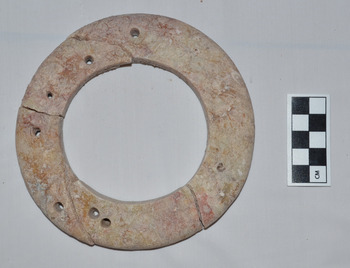
Figure 4. Marble bangle excavated at Lovea 2012
A coin with a thick lip and a square hole in its centre but no evidence of any characters was discovered in Burial 11 at Phum Lovea. It is similar to post-Western Han (206 BCE–23 CE) classical coins.Footnote 54 The piece bears a resemblance to a coin held in the Fitzwilliam Museum in the United KingdomFootnote 55 attributed to the Xin Dynasty or Wang Mang period c.9–23 CE (see fig. 5) and a very similar, Xin Dynasty coin is held by the Musée Guimet in Paris from an interment in Thung Thôn, Thanh Hó, Vietnam. Coins of this period have been found in Sa Huynh period burials in Vietnam.Footnote 56 It is impossible to say that the coin was placed in the grave at the time it was minted, but its presence does provide a terminus ante quem for the burial if the identification is accurate.

Figure 5. Coin excavated at Lovea (top left and right) x-ray of same; and a similar coin held by the Fitzwilliam Museum, Cambridge (bottom right, http://webapps.fitzmuseum.cam.ac.uk/explorer/index.php?do=Search&qu=Wang%20mang&size=10&from=10 accessed Dec. 2015 © The Fitzwilliam Museum 2000–2015)
Continuity of occupation
Evidence derived from landscape analysis and evaluation of the moats supports the contention that the increasing complexity and technological advancement witnessed at Iron Age Phum Lovea is a precursor to the sociocultural transformations of first millennium CE state-level polities in Cambodia. The site appears to be continuously occupied from the prehistoric period, and the nascent water management strategies employed at Phum Lovea may suggest the early manifestation of the sophisticated hydraulic system that becomes the hallmark of the later Kingdom of Angkor.
The mound complex of Phum Lovea was heavily modified during the prehistoric and/or Angkorian periods. There is evidence that the central mound of the site was altered at some stage into a rectangular shape, oriented to the northeast.Footnote 57 The dimensions are typically Angkorian, and the pronounced deviation in orientation towards the northeast is similar to features in the area around the western end of the West Baray. The existence of fine glazed ceramics at the site and the significant number of laterite temple blocks may attest to the existence of religious architecture here from the mid-first millennium CE onwards.
Scott Hawken, in his analysis of the landscape around Angkor, identified two sets of features, radial and linear.Footnote 58 The radial features comprise oxcart tracks and rice fields radiating out from a central prehistoric mound, of which Phum Lovea is an example. The tracks are argued to serve both a communicative and hydraulic purpose. The radial features integrate similarly patterned sites into contemporaneous clusters of settlements belonging to the prehistoric period.Footnote 59 In some places, the radial palimpsest is obscured by a linear rice field pattern, considered an Angkorian period characteristic. While these assumptions remain to be archaeologically tested, there is clear evidence that there exists a juxtaposition of linear and radial features around Phum Lovea. This may provide evidence for continued use and occupation of the site from prehistoric times through to the Angkor period and beyond. A string of similar radial sites to the north of Phum Lovea have been identified as prehistoric occupation mounds.Footnote 60 Within this cluster of radial sites there exists a number of overlying Angkor-period temples and ponds (trapeang) further demonstrating continued use of the area around Phum Lovea from the prehistoric into the historic period.
The water management strategies adopted in the prehistoric period at Phum Lovea appear to continue into the succeeding periods. The temples of Kok Chan and Banteay Sra, Angkorian foundations which are located nearby, have surrounding landscape grids that incorporate the prehistoric rice fields radiating from Phum Lovea.Footnote 61 Hawken concludes that ‘the Banteay Sra and Phum Lovea complex integrates a range of features from different periods’.Footnote 62 This suggests that the site was of prolonged importance to Greater Angkor, serving as an eastern gateway and metropolitan outpost during the Angkor period.
Discussion
We have presented the findings produced by the excavations at Phum Lovea, the analysis of the material culture as well as landscape of the site and its surrounds. The evidence for increasing cultural complexity witnessed at Lovea is supported by finds from other Cambodian sites in the country's northwest. There is strong evidence for the gradual incorporation, as there is in many parts of Southeast Asia, of Indic elements beginning during the Iron Age. Initially this is evidenced by the presence of traded items and later, in the historic period, cultural ideals, including laws, language and religion, art and architecture. The impact on the indigenous cultures of Southeast Asia was profoundly transformative.
Exchange and interaction extended to eastern regions (China) as well as to the west (South Asia) as evidenced by the presence of a Chinese coin at Phum Lovea. It is possible such items travelled up the Mekong and Tonlé Sap rivers from the Mekong Delta region. The presence of a ceramic lid with clear parallels to those found at Oc Éo and Angkor Borei, both hypothesised to have been incorporated in the polity known as Funan, indicates further possible connections between these regions. Oc Éo is a known entrepôt and excavations there indicate that the trade network in which Funan was involved was far-reaching. Roman artefacts are found at Oc Éo, including medallions minted under Antoninus Pius (c.152 CE) and Marcus Aurelius (c.161–80 CE), carnelian intaglios, and glass beads and braceletsFootnote 63 probably came via India. A coin bearing the image of a Persian king probably followed the same route.Footnote 64
There is evidence for communication and exchange of ideas across the Dang Raek Mountains as we find Phimai Black pottery similar to that of northeast Thailand in Iron Age interments in Prei Khmeng and in northwest Cambodia at Phum Sophy and Phum Snay.Footnote 65 Stylistic parallels are also evident between the regions with the marble bangle found at Phum Lovea bearing similarity to bangles found at Nong Nor, in southern coastal Thailand.
Phum Lovea and many of the Iron Age sites found in the Mun River Valley exhibit clear morphological parallels that may be indicative of knowledge/technology transfer. The analysis of both excavation and remote sensing data from Phum Lovea indicate that the moats and embankments around the site were anthropogenic in nature and were likely created to retain water to ensure adequate supplies during seasonal alterations or periods of prolonged drought, similar to those of northeast Thailand.Footnote 66 It is likely that these water retention features at Phum Lovea were constructed during the Iron Age. One of the main aspects of the Angkorian state was water managementFootnote 67 and the available data from Phum Lovea suggests that the moats around the site may have been precursors of this. Hawken's research supports this contention with the incorporation of pre-existing field patterns into evolving and growing agricultural techniques that arose in the Angkor period.
Conclusion
Archaeological research conducted at Iron Age sites in Cambodia provides evidence for the emerging sociopolitical complexity that culminates in the cultural transformations that characterise state-level polities in the region. We have evidence for increasing engagement in inter-regional trade and exchange networks, technological advances, social conflict and site morphology and economic development.
Phum Lovea, based on the available evidence, was occupied initially at some point in the first or second centuries CE with the radiocarbon dates suggesting use of the area as a cemetery from around the first to late fourth century CE. The inhabitants constructed the embankments and moats as a strategy to hold and manage water. The site continued to be occupied through the Angkorian period and seems to have been occupied continuously until the present.
While there is evidence that sites such as Phum Lovea and other contemporary sites in northwest Cambodia participated in interregional exchange networks and maintained a significant developmental position in the trajectory of sociopolitical transformation from the prehistoric to the historic period, it is clear that an expanded research effort is needed to further investigate this critical juncture in Southeast Asian prehistory.


