


1. Introduction
The Adventure Plateau occupies the NW sector of the Sicilian Channel (Fig. 1), which is part of the African continental plate. This plateau is morphologically separated from Tunisia by the Pantelleria Graben, a NW–SE-trending trough generated by rift-related processes which occurred during early Pliocene time (Civile et al. Reference Civile, Lodolo, Accettella, Geletti, Ben-Avraham, Deponte, Facchin, Ramella and Romeo2010). This depression defines the southern limit of the Adventure Plateau, a shallow and relatively flat carbonate platform which was affected by a late Miocene compressional tectonic phase responsible for the building of the external sector of the Sicilian–Maghrebian thrust belt (e.g. Argnani et al. Reference Argnani, Cornini, Torelli and Zitellini1987; Argnani Reference Argnani and Colantoni1993a , Reference Argnani, Boschi, Mantovani and Morelli b , Reference Argnani, Van Hinsbergen, Edwards and Govers2009; Civile et al. Reference Civile, Lodolo, Alp, Ben-Avraham, Cova, Baradello, Accettella, Burca and Centonze2014). Within the Adventure Plateau, a series of isolated morphological reliefs (Fig. 2) were individuated in the past by sparse bathymetric and high-resolution seismic profiles (Colantoni et al. Reference Colantoni, Cremona, Ligi, Borsetti and Cati1985); the lithological nature of some was investigated by rock sampling (Calanchi et al. Reference Calanchi, Colantoni, Rossi, Saitta and Serri1989). Only recently, however, their shape, size and detailed geomorphological setting have been imaged by swath bathymetric mapping and dense high-resolution seismic surveys (Civile et al. Reference Civile, Lodolo, Zecchin, Ben-Avraham, Baradello, Accettella, Cova and Caffau2015). These data have allowed the reconstruction of the late Quaternary palaeogeography of this sector of the Sicilian Channel, and the identification of specific morphological markers associated with the post-LGM (Last Glacial Maximum) sea-level rise. These bathymetric highs, some of which comprised relict sedimentary outcrops and others submarine volcanic edifices, formed a broad archipelago of kilometre-sized islands until around late Holocene time (Lodolo, Reference Lodolo2012). However, the deep structural setting of these banks still remains largely unknown. In particular, we do not know in detail how the two main tectonic events that have influenced the geological history of this area (i.e. the late Miocene compressional phase and the Pliocene–Pleistocene extensional phase) contributed to the generation and the subsequent tectonic evolution of these submerged banks.

Figure 1. Morpho-bathymetric and simplified structural map of the Sicilian Channel and surrounding regions. Bathymetric data are taken from the International Bathymetric Chart of the Mediterranean (IBCM) (http://www.ngdc.noaa.gov/mgg/ibcm/ibcm.html) and from the CIESM/IFREMER map of the Mediterranean seafloor (http://www.ciesm.org/marine/morphomap.htm), integrated with data from Civile et al. (Reference Civile, Lodolo, Accettella, Geletti, Ben-Avraham, Deponte, Facchin, Ramella and Romeo2010). Topographic elevations are taken from the Shuttle Radar Topography Mission (SRTM) (http://www2.jpl.nasa.gov/srtm). Main structural features and the areal extent of the two upper Neogene – Quaternary foredeeps of the Sicilian Channel are also indicated (from various authors). The white dotted line indicates the palaeo-shoreline at the LGM (after Vai & Cantelli, Reference Vai and Cantelli2004; Civile et al. Reference Civile, Lodolo, Zecchin, Ben-Avraham, Baradello, Accettella, Cova and Caffau2015). AP – Adventure Plateau; TZ – NS-trending transfer zone; ETF – Egadi Thrust Front; MTF – external front of the Sicilian–Maghrebian thrust belt. Box in the upper-left corner locates the Sicilian Channel within the central Mediterranean Sea.
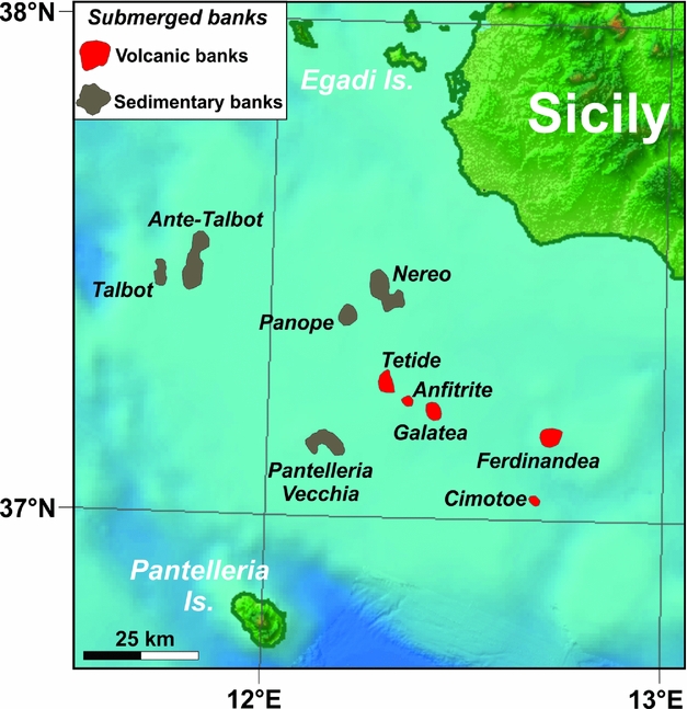
Figure 2. Detailed morpho-bathymetric map of the Adventure Plateau, with the location of both the sedimentary and volcanic submerged banks.
In this paper, we present the results of an analysis of both high-resolution seismic data and multichannel seismic profiles, integrated with swath bathymetric data and stratigraphic information derived from oil wells and rock samplings on several submerged shallow reliefs of the Adventure Plateau. Our aim is: (1) to derive the deep structural framework of these banks; (2) to investigate their present-day architecture with respect to the tectonic phases which affected the NW sector of the Sicilian Channel; and (3) to reconstruct origin, age and palaeoenvironmental setting of the shoals through the analyses of sampled rocks.
2. Geological and structural setting of the Sicilian Channel
Belonging to the northern African margin (also called the Pelagian block; Burollet et al. Reference Burollet, Mugniot, Sweeney, Nairn, Kanes and Stelhi1978), the Sicilian Channel is characterized by water depths generally shallower than 400 m, with the exception of three NW-trending, elongated tectonic depressions (Fig. 1) produced by early Pliocene continental rifting: the Malta, Linosa and Pantelleria graben (e.g. Jongsma, Van Hinte & Woodside, Reference Jongsma, Hinte and Woodside1985; Reuther & Eisbacher, Reference Reuther and Eisbacher1985; Boccaletti, Cello & Tortorici, Reference Boccaletti, Cello and Tortorici1987; Cello, Reference Cello1987; Dart, Bosence & McClay, Reference Dart, Bosence and McClay1993; Civile et al. Reference Civile, Lodolo, Accettella, Geletti, Ben-Avraham, Deponte, Facchin, Ramella and Romeo2010). This rift cross-cuts the former NE-trending thrust faults and foredeep basin associated with the offshore Sicilian–Maghrebian thrust belt (Cello, Reference Cello1987; Catalano & Milia, Reference Catalano, Milia, Pinet and Bois1990; Casero & Roure, Reference Casero, Roure and Roure1994; Catalano et al. Reference Catalano, Torrisi, Tortorici and Romagnoli2011). The rifting process was accompanied by a widespread magmatic activity that generated the two volcanic islands of Pantelleria and Linosa and several submarine edifices, among them Tetide, Galatea, Anfitrite and Cimotoe (e.g. Carapezza et al. Reference Carapezza, Ferla, Nuccio and Valenza1979; Beccaluva et al. Reference Beccaluva, Colantoni, di Girolamo and Savelli1981; Calanchi et al. Reference Calanchi, Colantoni, Rossi, Saitta and Serri1989; Rotolo et al. Reference Rotolo, Castorina, Cellula and Pompilio2006; Lodolo et al. Reference Lodolo, Civile, Zanolla and Geletti2012). The volcanism took place during Pliocene–Pleistocene time (Calanchi et al. Reference Calanchi, Colantoni, Rossi, Saitta and Serri1989; Rotolo et al. Reference Rotolo, Castorina, Cellula and Pompilio2006), although some manifestations have occurred up to historical time with the emergence and rapid disappearance of the Ferdinandea Island in ad 1831 (Colantoni et al. Reference Colantoni, Del Monte, Gallignani and Zarudzki1975) and a submarine eruption (Foerstner volcano) occurred in ad 1891 c. 5 km NW of Pantelleria Island (Washington, Reference Washington1909).
In the northern sector of the Sicilian Channel, two tectonic domains of the Sicilian–Maghrebian thrust belt are superimposed. The first is known as the ‘external thrust system’ (Lentini et al. Reference Lentini, Carbone, Catalano, Grasso and Monaco1990; Lentini, Carbone & Catalano, Reference Lentini, Carbone and Catalano1994, Reference Lentini, Carbone and Catalano1996), which represents the lowermost structural level of the thrust belt, resulting from the deformation of the internal part of the carbonate Pelagian block. It is composed of Mesozoic–Cenozoic shallow–deep-water carbonates and Miocene terrigenous and clastic carbonate deposits (Casero & Roure, Reference Casero, Roure and Roure1994; Catalano et al. Reference Catalano, Franchino, Merlini and Sulli2000). The second is the Apenninic–Maghrebian orogenic domain (Lentini et al. Reference Lentini, Carbone, Catalano, Grasso and Monaco1990; Lentini, Carbone & Catalano, Reference Lentini, Carbone and Catalano1994) which consists of a thick pile of rootless nappes derived from the Oligocene–Neogene deformation of the Mesozoic–Cenozoic deepwater and carbonate platform deposits (Lentini et al. Reference Lentini, Carbone and Catalano1996; Lentini, Carbone & Guarnieri, Reference Lentini, Carbone, Guarnieri, Dilek and Pavlides2006). The overlap of these two tectonic domains occurs at the Egadi Thrust Front (Catalano, Infuso & Sulli, Reference Catalano, Infuso and Sulli1995; Fig. 1). Two distinct foredeeps of the Sicilian–Maghrebian thrust belt can be recognized in the Sicilian Channel (Fig. 1): (1) a NE-trending upper Tortonian – lower Messinian deformed foredeep located in the NW part of the Sicilian Channel, referred to as the Adventure foredeep on the Adventure Plateau (Argnani et al. Reference Argnani, Cornini, Torelli and Zitellini1986, Reference Argnani, Cornini, Torelli and Zitellini1987; Argnani Reference Argnani and Colantoni1993a , Reference Argnani, Boschi, Mantovani and Morelli b ); and (2) the Pliocene–Quaternary WNW-trending Gela foredeep, limited by the external front of the Sicilian–Maghrebian thrust belt (Argnani et al. Reference Argnani, Cornini, Torelli and Zitellini1986, Reference Argnani, Cornini, Torelli and Zitellini1987; Lickorish et al. Reference Lickorish, Grasso, Butler, Argnani and Maniscalco1999, among others).
The Adventure Plateau is a Mesozoic–Cenozoic shallow shelf morphologically separated from Sicily by a relatively deep channel (c. 120 m) and from Tunisia by the Pantelleria Graben (c. 1300 m). The sedimentary succession of the Adventure Plateau, reconstructed by the analysis of available exploration wells that in some cases reached depths of 5 km, is composed of a Triassic–Eocene predominantly carbonate interval and of a mostly siliciclastic Oligocene–Quaternary succession (Civile et al. Reference Civile, Lodolo, Alp, Ben-Avraham, Cova, Baradello, Accettella, Burca and Centonze2014). This flat platform was possibly emergent during long periods, as testified by the occurrence of several hiatuses. The Adventure Plateau is the shallowest part of the entire Sicilian Channel, and is punctuated by several isolated banks (see Fig. 2) which rise up to less than 10 m below sea level (Colantoni et al. Reference Colantoni, Cremona, Ligi, Borsetti and Cati1985). Some of them (Talbot, Ante-Talbot and Pantelleria Vecchia banks) represent remnants of highly deformed and tectonized sedimentary substratum which were eroded during repeated phases of subaerial exposure (Colantoni et al. Reference Colantoni, Cremona, Ligi, Borsetti and Cati1985; Antonelli et al. Reference Antonelli, Franciosi, Pezzi, Querci, Ronco and Vezzani1988; Civile et al. Reference Civile, Lodolo, Zecchin, Ben-Avraham, Baradello, Accettella, Cova and Caffau2015). Analysis of seismic reflection profiles, combined with sedimentation rates and the curve of global eustatic sea-level change, showed that during the LGM the Adventure Plateau formed a large peninsula protruding into the Sicilian Channel, separated from the North African coastline by less than 50 km (Vai & Cantelli, Reference Vai and Cantelli2004; Civile et al. Reference Civile, Lodolo, Zecchin, Ben-Avraham, Baradello, Accettella, Cova and Caffau2015). The gradual increase of the sea level caused the flooding of most of the peninsula with the exception of some morphological highs that, until around early Holocene time, formed an archipelago of several islands separated by stretches of extremely shallow sea (Lodolo, Reference Lodolo2012; Civile et al. Reference Civile, Lodolo, Zecchin, Ben-Avraham, Baradello, Accettella, Cova and Caffau2015).
The structural setting of the Adventure Plateau is the result of two independent tectonic processes: (1) the building of the frontal belt of the Sicilian–Maghrebian thrust belt during late Miocene time (Antonelli et al. Reference Antonelli, Franciosi, Pezzi, Querci, Ronco and Vezzani1988; Argnani, Reference Argnani and Colantoni1993a , Reference Argnani, Boschi, Mantovani and Morelli b , Reference Argnani, Van Hinsbergen, Edwards and Govers2009); and (2) the continental rifting which affected the northern African margin from early Pliocene time (Civile et al. Reference Civile, Lodolo, Accettella, Geletti, Ben-Avraham, Deponte, Facchin, Ramella and Romeo2010), generating the Pantelleria, Malta and Linosa troughs. The late Miocene compressional deformation, coeval with the opening of the Tyrrhenian Sea, produced tectonic slices partially detached from their carbonate substratum, separated by ESE-verging thrusts and back-thrusts (Catalano et al. Reference Catalano, Franchino, Merlini and Sulli2000). This phase was chiefly Tortonian in age (Antonelli et al. Reference Antonelli, Franciosi, Pezzi, Querci, Ronco and Vezzani1988) as indicated by the Tortonian – early Messinian sedimentary fill (Terravecchia Formation) of the Adventure foredeep basin that was affected by only limited compressive deformations during Messinian time (Grasso, Reference Grasso, Vai and Martini2001; Argnani, Reference Argnani, Van Hinsbergen, Edwards and Govers2009). The extensional phase produced mostly NW-trending, high-angle normal faults related to the continental rifting phase, which generated the Pantelleria Graben. The eastern boundary of the Adventure Plateau is controlled by a broadly north-trending lithospheric transfer zone (e.g. Argnani et al. Reference Argnani, Cornini, Torelli and Zitellini1986; Antonelli et al. Reference Antonelli, Franciosi, Pezzi, Querci, Ronco and Vezzani1988; Argnani, Reference Argnani1990; Civile et al. Reference Civile, Lodolo, Accettella, Geletti, Ben-Avraham, Deponte, Facchin, Ramella and Romeo2010) where structural lineaments with a predominantly strike-slip motion and several magmatic manifestations have been recognized. This zone separates sectors of the Sicilian–Maghrebian thrust belt with a different deformation age, distinct structural trends and tectonic evolution (Argnani et al. Reference Argnani, Cornini, Torelli and Zitellini1987; Argnani, Reference Argnani and Colantoni1993a , Reference Argnani, Boschi, Mantovani and Morelli b ; Grasso, Reference Grasso, Vai and Martini2001).
3. Simplified stratigraphy of the Adventure Plateau
The stratigraphic succession of the Adventure Plateau was reconstructed through the analysis of 16 oil exploration wells available in this area (website ViDEPI: http://unmig.sviluppoeconomico.gov.it/videpi). These wells, all located on structural highs, were drilled between 1973 and 1991. The stratigraphic synthesis described here complements and expands the analysis already published by Civile et al. (Reference Civile, Lodolo, Alp, Ben-Avraham, Cova, Baradello, Accettella, Burca and Centonze2014).
The stratigraphic succession consists of sedimentary deposits ranging from Late Triassic to Pliocene–Pleistocene (Fig. 3), containing several stratigraphic gaps caused by erosion and/or by non-deposition or due to tectonic deformations. The main gaps are observed at the top of the Miocene deposits (Messinian Erosional Surface, MES), at the top of the middle Miocene deposits, at the top of the Palaeogene deposits and at a significant Jurassic gap that sometimes extends to the entire Jurassic succession. The Jurassic gap may be correlated to the establishment of restricted marine conditions, which started during the latest Triassic and continued into the Early Jurassic (Assereto & Benelli, Reference Assereto, Benelli and Gray1971; Hammuda et al. Reference Hammuda, Sbeta, Mouzughi and Eliagoubi1985). In northern Africa, a marked hiatus involving almost the entire Lower Jurassic is documented (Keeley et al. Reference Keeley, Dungworth, Floyd, Forbes, Kin, McGarva and Shaw1990; Keeley & Massoud, Reference Keeley, Massoud, MacGregor, Moody and Clark-Lowes1998).

Figure 3. Simplified lithostratigraphic column of the Adventure Plateau, derived from a series of oil exploration wells.
The Upper Triassic (Taormina Formation) – Liassic (Inici Formation) shallow-marine succession consists of a thick dolomite sequence of flat tidal environment with rare intercalations of dolomitized packstone-grainstone and thin layers of clay, marls and, in the upper part, anhydrite. The Triassic deposits have only been drilled by four wells (Carla 1, Orlando 1, Paola Est 1 and Oscar Ovest 1) for several hundred metres (over 3000 m in Paola Est 1 well). The Liassic part was drilled for 100–150 m in three wells (Vallo 1, Sirio 1 and Nanda 1).
The Middle Jurassic – Eocene pelagic succession is characterized by the presence of two predominantly marly intervals in the Barremian–Albian deposits (Hybla Formation) and in the Maastrichtian – lower Eocene succession (El Haria Formation). In particular, the Dogger-Malm deposits have been observed in three wells (Carla 1, Paola Est 1 and Nanda 1). A roughly 350 m thick Dogger-Malm succession is present in Carla 1 well and composed of pelagic mudstone-wackestone limestones, sometimes packstones and locally clayey, with rare and thin marly and clay intercalations. The Neocomian interval (Busambra Formation), not always present, consists of 70–200-m-thick mudstone-wackestone limestones, sometimes clayey and with nodules of chert.
The Barremian–Albian succession (Hybla Formation) consists of 70–600 m of clayey mudstones with marly intercalations in the lower part (Barremian) and of marls and clays with intercalations of marly mudstone-wackestone in the upper part. The Cenomanian–Campanian succession (Amerillo Formation) is generally composed of 150–400 m of wackestone-mudstone limestones and minor packstones, sometimes clayey or with nodules of chert and rare thin levels of marl and clay. The Maastrichtian – lower Eocene interval (El Haria Formation) consists of 60–400 m of marls and clays with levels of clayey mudstone-wackestone limestones. The middle–upper Eocene succession (Souar Formation) consists of c. 100–250 m of clayey wackestone-mudstone and more rarely of packstone limestones, sometimes with nodules of chert and rare intercalations of marls and clays. The neritic upper Oligocene – lower Miocene Fortuna Formation, which is generally absent, is composed of 40–80 m of fine- to medium-grained quartz sandstones, clays and marls. In Nettuno 1 well, this formation is some hundreds of metres thick and consists of a clayey succession with rare arenaceous levels.
The Langhian Ain-Grab Formation, with a variable thickness from a few metres to 150 m, shows a remarkable lithological heterogeneity. This succession, deposited both in slope, shelf and littoral environments, can be entirely siliciclastic with fine- to medium-grained quartz sandstones and thin clay intercalations, or predominantly carbonate with packstone-wackestone limestones and rarely mudstones with thin marly and clayey intercalations.
The Langhian–Serravallian Mahmoud Formation, which is sometimes absent, generally consists of 40–300 m of clayey wackestone-packestone limestones with marl and clay intercalations (Sirio 1 well). The karstified packstone-grainstone limestones of the Serravallian Nilde Formation, 50–200 m thick and of shallow-water and slope environments, have only been recognized in the NW sector of the Adventure Plateau.
The Tortonian–Messinian Terravecchia Formation is the most widespread and the thickest (800 to >1800 m, with the exception of the Oscar Ovest 1 well where the thickness is c. 100 m) Miocene succession in the study area. It is composed of clay, silty clay with thin levels of fine quartz sandstones, and the uppermost part is composed of fine- to coarse-grained quartz sands with intercalations of polygenic gravels and silty clay. Above this succession, but not everywhere, lay the Messinian evaporites of the Gessoso–Solfifera Formation consisting of 70–300 m of crystalline gypsum with intercalations of clay, marl and coarse limestones. These deposits, associated with the Messinian salinity crisis during which the Mediterranean sea was isolated from the open ocean with the consequent establishment of hyper-saline conditions, are located on structural highs generated by the late Miocene thrust tectonics or connected to the presence of relatively deep basins.
Finally, the Pliocene–Pleistocene Ribera Formation, of thickness 80–400 m, shows a wide lithological heterogeneity. The lower part is composed of chalky marls and carbonate mudstones that can be correlated with similar early Pliocene pelagic deposits in Sicily (Trubi Formation). Above this, packstone-grainstone limestones with rare intercalations of clay and sandstone of a neritic environment are present. In the Oscar Ovest 1, Corvina Mare 1, Paola Est 1 and Carla 1 wells, this succession is predominantly siliciclastic and consists of clays, marls with levels of mudstones and calcareous marls.
4. Rock sample analyses
Rock fragments were recovered by divers in some locations of the Pantelleria Vecchia Bank (Fig. 4) during a series of surveys. Macroscopic and microscopic analysis, along with micropalaeontological content analysis, were performed and here we summarize the main results. Samples are identified by numbers, with the corresponding water depths at which the rock fragments were acquired also recorded. A thin-section was made from a harder limestone sample (sample 4) while softer samples (3A, 5, 6, 8A and 9A) were disaggregated. For each of the soft samples, c. 50 g of material was dried at 50°C for 24 hours and then treated with hydrogen peroxide (10% vol) for 12 hours. The samples were then washed through a 63 μm mesh, dried and the residue was examined for foraminiferal contents. The genera of the benthic foraminifera identified in the samples were determined following the taxonomic order of Loeblich & Tappan (Reference Loeblich and Tappan1988).

Figure 4. (a) Location of the rock samples analysed (white numbers), superimposed onto a swath bathymetric map of the Pantelleria Vecchia Bank. (b) Photographs of the rock samples. Sample 3A: (I) and disaggregated sediment (IA) with Borelis melo melo (a), tangential section of Borelis melo melo (b) and Triloculina gibba (c). Disaggregated sediment (IB) with Borelis melo melo (a), Quinqueloculina sp. (b) and spine of echinoid (c). Sample 4: (II) and thin-section (IIA) with branches of Lithophyllum and thin-section with Discoporella sp. (IIB). Sample 5: (III) and disaggregated sediment (IIIA) with Elphidium sp. (a), fish teeth (b) and gastropods (c). Disaggregated sediment (IIIB) with coralline algal fragments (a), Elphidium sp. (b) and gastropods (c). Sample 6: (IV) and disaggregated sediment (IVA) with Borelis melo melo (a) and Spiroloculina excavata (b). Disaggregated sediment (IVB) with Quinqueloculina sp. (a) and Elphidium sp. (b). Sample 8A: (V) and disaggregated sediment (VA) with Borelis melo melo (a) and tangential section of Boris melo melo (b). Disaggregated sediment (VB) with three individuals of Boris melo melo. Sample 9A: (VI) and disaggregated sediment (VIA) with Borelis melo melo (a) and Quinqueloculina boueana (b). Disaggregated sediment (VIB) with Borelis melo melo (a), Textularia mariae (b) and Elphidium sp. (c).
Sample 3A (water depth 36 m) is a calcarenite composed of slightly cemented bioclastics; it also contains a siliciclastic fraction consisting of quartz sandstone. The biogenic fraction is mainly characterized by benthic foraminifera: Ammodiscus sp., Textularia sp., Spiroloculina sp., Cycloforina sp., Pyrgo sp., Quinqueloculina boueana, Triloculina gibba, Borelis melo melo, Nonion sp., Nonionella sp., Ammonia beccarii and Elphidium spp. In addition, rare bryozoans, ostracods and gastropods were also found, as well as rare spines of echinoids. The taxa Borelis melo melo, Quinqueloculina and Triloculina are the most abundant forms in this association, representing more than 60% of the foraminifera present in this sample.
Sample 4 (water depth 27 m) is an algal-bryozoan limestone composed of abundant branches of Lithophyllum sp. and free bryozoans, in particular Discoporella sp. In addition, the following taxa of benthic foraminifera were recognized: Quinqueloculina sp., Rosalina cf. brady, Ammonia sp., Pararotalia sp., Elphidium spp. as well as serpulid, molluscs and gastropods. This sample derives from a coralline algal build-up, as testified by the presence of branches of Lithophyllum sp.
Sample 5 (water depth 35 m) is a bioclastic calcarenite. The bioclastic component, slightly cemented, is mostly composed of mollusc shells, gastropods, bryozoans and coralline algal fragments. In the sample, benthic foraminifera remains are relatively poor and no planktonic foraminifera were recovered. Other than the few foraminifera recovered, some rare ostracods were found as well as the remains of spines of echinoids and fish teeth. In this sample the following benthic foraminera taxa were identified: Ammodiscus sp., Textularia sp., Cycloforina sp., Q. boueana, Triloculina sp., Borelis melo melo, Nonionella sp., A. beccarii and Elphidium spp. The abundance of bioclastic articulate coralline algae was determined to be the result of the adjacent coralline algal framework.
Sample 6 (water depth 41 m) is a calcarenite composed of a slightly cemented bioclastic that also contains a siliciclastic fraction consisting of quartz sandstone. The biogenic fraction is mainly characterized by the following taxa of benthic foraminifera: Textularia mariae, Textularia sp., Spiroloculina excavata, Cycloforina sp., Pyrgo sp., Quinqueloculina boueana, Quinqueloculina sp., T. gibba, Triloculina sp., Lenticulina sp., Borelis melo melo, Nonion sp., Nonionella sp., Ammonia beccarii and Elphidium spp. In addition, rare bryozoans, ostracods and gastropods were also found, as well as very rare spines of echinoids. Planktonic foraminifera are absent. The taxa Borelis melo melo, Quinqueloculina and Triloculina are the most abundant forms in this association, and represent more than 60% of the foraminifera collected in this sample.
Sample 8A (water depth 37 m) is a calcarenite very similar in composition to sample 6. The bioclastic detritus (fragments <2 mm in size) is mostly composed of mollusc shell, bryozoan and coralline algal fragments. The benthic foraminifera fraction consists of the same taxa identified in sample 6. Planktonic foraminifera are absent. The taxa Borelis melo melo, Quinqueloculina and Triloculina are the most abundant form in this association, representing >70% of the foraminifera present in this sample.
Sample 9A (water depth 36 m) is also a calcarenite, similar in composition and texture to samples 6 and 8A, and is characterized by the same foraminifera content as these samples. In addition to the foraminifera recovered, rare bryozoans, ostracods and gastropods were also found, as well as very rare spines of echinoids and fish teeth. Planktonic foraminifera are absent. The taxa Borelis melo melo, Quinqueloculina and Triloculina are the most abundant forms in this association, representing >50% of the foraminifera within this sample.
As observed, the foraminifera taxa Borelis melo melo, Quinqueloculina and Triloculina are abundant in all samples except for sample 4. These taxa generally testify a tolerance to warm waters (c. 18–27°C), according to Murray (Reference Murray2006). The presence of coralline algal build-ups is mostly testified by sample 4, which comes from a solid framework generated by Lythophyllum sp., indicating a shallow-water marine environment (Flügel, Reference Flügel2010). The bioclastic component of sample 5 derives from detritic talus around and in the vicinity of the coralline algal frameworks. The chronostratigraphic attribution is based on the occurrence of Borelis melo melo. This taxa suggests a Tortonian age, as described by several authors in coeval successions of the Sicilian Channel region (Pedley, Reference Pedley1978; Van der Zwaan, Reference Van der Zwaan1982; Grasso & Pedley, Reference Grasso and Pedley1985; Moisette et al. Reference Moisette, Cornée, Mannaï-Tayech, Rabhi, André, Koskeridou and Méon2010).
5. Morpho-structural setting of the Adventure Plateau banks
High-resolution, single-channel seismic profiles (Chirp profiles and Boomer profiles) and 2D multichannel seismic reflection lines (Fig. 5) have been interpreted in order to determine the morpho-structural setting of the banks of the Adventure Plateau. Chirp profiles were acquired by the R/V OGS-Explora during different surveys (November 2012 and 2013) with a keel-mounted system. The Boomer data were recorded during February 2014 using a portable system comprising a floating Boomer plate as an energy source installed on a catamaran, and a 10-m-long mini-streamer composed of 10 hydrophones as a signal receiver. This high-resolution seismic system was installed on a boat made available from the Italian Arma dei Carabinieri of Mazara del Vallo (Sicily). Details of the Chirp equipment and acquisition parameters can be found in Civile et al. (Reference Civile, Lodolo, Zecchin, Ben-Avraham, Baradello, Accettella, Cova and Caffau2015). Multichannel seismic data presented here are from the ViDEPI website (http://unmig.sviluppoeconomico.gov.it/videpi/). The present-day morphological configuration of these banks is the result of the interaction between tectonic deformations and repeated phases of subaerial exposure and drowning, which shaped the banks according to the degree of erosion of the composing rocks and the rate of relative sea-level rise.

Figure 5. Location map of the high-resolution single-channel and 2D multichannel seismic reflection profiles presented in this study. Some exploratory oil wells are also shown.
5.a. Volcanic banks
Tetide, Anfitrite and Galatea seamounts are three submerged volcanic reliefs located in the central part of the Adventure Plateau (see Fig. 2). They are quite close to each other (less than 10 km apart) and oriented 120°N, a trend which is roughly parallel to the Pantelleria Graben axis. The morphology and shallow structural setting of the Galatea seamount derives solely from published data by Calanchi et al. (Reference Calanchi, Colantoni, Rossi, Saitta and Serri1989). Cimotoe, another volcanic high, is located a bit further from the other three along the SE margin of the Adventure Plateau at a depth of c. 200 m. The magma types of these volcanic edifices vary from quartz tholeiites to olivine or transitional basalts, and are as old as Pleistocene in age as shown by rock samples recovered by diving on the summits of Tetide and Anfitrite seamounts (Calanchi et al. Reference Calanchi, Colantoni, Rossi, Saitta and Serri1989). Galatea, which shows an extremely well-preserved original cone shape with a probable summit crater, was not directly sampled; seismic and magnetic data however testify that it is of volcanic nature (Calanchi et al. Reference Calanchi, Colantoni, Rossi, Saitta and Serri1989). Similarly, the volcanic nature of the Cimotoe seamount is inferred solely based on magnetic anomalies (Calanchi et al. Reference Calanchi, Colantoni, Rossi, Saitta and Serri1989).
Tetide occupies c. 9 km2 and rises from the seafloor located at c. 70 m. It reaches a minimum water depth of 34 m and represents the major volcanic edifice of the Adventure Plateau. The shallow structure of this seamount was imaged by the Boomer profile VUL-02/03 (Fig. 6), which crosses the whole edifice from the NW to the SE. In this profile, the flanks of the bank are quite regular and symmetric and the entire volcanic edifice is covered by a thin cover of Holocene deposits. The seismic line does not show the morphologies associated with volcanic cones or calderas.

Figure 6. Boomer profile VUL-02/03 crossing the Tetide submarine volcanic edifice and corresponding line drawing. See location of profile in Figure 5.
Anfitrite seamount, located a few kilometres to the SE of Tetide, was for the first time identified by Colantoni et al. (Reference Colantoni, Cremona, Ligi, Borsetti and Cati1985) by sparse high-resolution seismic profiles and bathymetric soundings. Recent detailed swath bathymetric mapping (Civile et al. Reference Civile, Lodolo, Zecchin, Ben-Avraham, Baradello, Accettella, Cova and Caffau2015) has shown the presence of two distinct morphological highs, named Anfitrite 1 and Anfitrite 2, rising from a seafloor that has a depth of 60–90 m. Anfitrite 1 covers an area of c. 1.8 km2 and presents a semicircular shape with a diameter of c. 1.5 km. Its volcanic nature can be hypothesized by the presence in the southern part of the bank of an obvious caldera (diameter c. 500 m). Its flat-topped NE rim lies at c. 35 m below sea level, and represents the shallowest part of Anfitrite seamount. A ridge with a semicircular shape that might represent a remnant of a major dismantled volcanic edifice occupies the NW part of Anfitrite 1. In the NE part of this bank, a small elliptical morpho-structure probably related to an adventitious volcanic cone is observable (diameter c. 150 m). Anfitrite 2 is composed of a ridge with the shallowest peak reaching 40 m below sea level, developed for >1.5 km in a NNE direction, with a maximum width of c. 1 km. The volcanic nature of this ridge was determined from the analysis of a sample collected by scuba divers from the southern top of the ridge at 45 m depth (Calanchi et al. Reference Calanchi, Colantoni, Rossi, Saitta and Serri1989), which represents a massive and fractured basaltic lava of tholeiitic affinity. The Chirp profile AB-11 (Fig. 7) crosses both Anfitrite 1 and Anfitrite 2. In Anfitrite 1, a caldera bound by a rim and filled with several metres of Holocene deposits is recognizable at c. 40 m below sea level. A well-preserved volcanic neck is also imaged by the seismic data. Anfitrite 2 does not show a prominent volcanic feature, is free of sediment and its top lies at c. 37 m below sea level. The NE flank is relatively steep and limited by a subvertical scarp interpreted as a palaeo-coastal cliff.

Figure 7. Chirp profile AB-11 crossing the Anfitrite 1 and 2 submarine volcanic edifices and corresponding line drawing. A morphological element associated with the post-LGM marine trangression (palaeo-coastal cliff) is indicated. See location of profile in Figure 5.
The deep structure of the Anfitrite Bank can be reconstructed by analysing the multichannel seismic profile C-1010 which crosses the bank in a SW–NE direction (Fig. 8). The two magmatic ascents generating Anfitrite 1 and 2 can be observed. Anfitrite 2 seems to be the major volcanic edifice. Another three buried magmatic manifestations are clearly recognizable to the SW of Anfitrite 1. In particular, the buried magmatic ascent located between shot points 250 and 260 seems to be the most extended. These magmatic ascents can be related to the presence of a large magmatic intrusion, which breaks and deforms the sedimentary succession in a domed shape at a shallow crustal level (at c. 1 km depth). The top and base of the Tortonian–Messinian succession, including Terravecchia and Gessoso–Solfiera formations, have been clearly recognized in the seismic line. These reflectors show a strong acoustic impedance and considerable lateral continuity. Moreover, the top of the Miocene succession is seismically expressed by a largely undulating surface breaking the succession below.

Figure 8. Multichannel seismic profile C-1010 traversing both the Anfitrite volcanic edifices and corresponding line drawing. See location of profile in Figure 5.
5.b. Sedimentary banks
The sedimentary shoals that punctuate the Adventure Plateau are represented by the Pantelleria Vecchia, Nereo, Panope, Ante-Talbot and Talbot banks (see Fig. 2). The Pantelleria Vecchia Bank is located 40 km north of the volcanic Island of Pantelleria in an area affected by late Miocene compressional structures dissected by NW-trending, high-angle normal faults associated with the continental rifting that produced the Pantelleria Graben from early Pliocene time. High-resolution swath bathymetric data (Civile et al. Reference Civile, Lodolo, Zecchin, Ben-Avraham, Baradello, Accettella, Cova and Caffau2015) show that this bank, covering a total area of 5.2 km2, is made up of two main flat rocky shoals of rectangular shape separated by a narrow channel and some smaller islets located in the SW. The main shoals lie at a water depth of 16–24 m, while the surrounding areas are located at depths in the range 46–60 m. The shoals and the alignment of islets are limited by rectilinear NW-trending scarps (125–135°N), probably associated with major faults parallel to the structures that generated the Pantelleria Graben. The internal part of the banks is affected by minor faults and fractures. Several high-resolution seismic records have delineated the main shallow structure of this bank, and here we show a representative profile (profile PVB-16) crossing the southern part of the larger rocky shoal (Fig. 9). It is acoustically impenetrable and free of sediment. It is bounded by high-angle normal fault-scarps while the top lies at depths in the range 20–28 m. In the area between the main shoal and the cropping out alignment of islets, the basement shows an articulate morphology and is generally covered by Holocene deposits up to 8 m thick. The alignment of islets is bounded by a buried palaeo-coastal cliff.

Figure 9. Chirp profile PVB-16 crossing the Pantelleria Vecchia Bank and corresponding line drawing indicating a morphological element associated with the post-LGM marine trangression (buried palaeo-coastal cliff). See location of profile in Figure 5.
The deep structural setting of the Pantelleria Vecchia Bank is imaged by the multichannel seismic profile C-1015 that crosses the bank in a NW–SE direction (Fig. 10). The top and base of the Tortonian–Messinian succession have been mapped on the basis of their seismic features and on the information derived from Orlando 1 and 2 exploratory wells, located c. 3 km from the seismic line. The Pantelleria Vecchia Bank is the surface expression of a wide anticline produced by a late Miocene NW-verging major blind back-thrust. This structure, together with minor back-thrusts located in the footwall, form an imbricate fan structure. Many other SE-verging thrust-faults, with modest displacement, are well recognizable. The late Miocene compressional phase probably occurred in an area where a previous extensional tectonic phase, likely Mesozoic in age, generated a structural high (horst) bounding a former basin. This is testified by the significant and sudden change in thickness of the late Miocene succession recognizable along the profile; this consideration cannot be extended to the succession below due to the poor quality of the seismic line. However, it cannot be excluded that the observed back-thrust is the result of an episode of positive tectonic inversion, documented both in the Adventure Plateau (Roure, Casero & Addoum, Reference Roure, Casero and Addoum2012) and in other locations of the Sicilian Channel (Casero & Roure, Reference Casero, Roure and Roure1994). According to Casero & Roure (Reference Casero, Roure and Roure1994) and Roure, Casero & Addoum (Reference Roure, Casero and Addoum2012), the tectonic inversion affected Triassic and Liassic normal faults inherited from the Tethyan rifting which began during Late Cretaceous – Palaeogene time. Finally, NW-trending normal faults, with modest offset, affect the upper part of the Pantelleria Vecchia anticline where the Pliocene–Quaternary cover is absent.

Figure 10. Multichannel seismic profile C-1015 traversing the Pantelleria Vecchia Bank and corresponding line drawing. See location of profile in Figure 5.
The Talbot and Ante-Talbot banks are located along the NW margin of the Adventure Plateau in the vicinity of the Egadi Thrust Front. A relatively deep and narrow channel separates these two shoals. The Ante-Talbot Bank has been sampled by scuba divers (Colantoni, Reference Colantoni1975) who recovered sandstones (quartz-arenites) with macro-foraminifera and mollusc fragments, attributed to a generic Oligocene–Miocene age based on lithological similarities with successions cropping out in northern Tunisia. Two rock samples were collected by scuba divers at water depths of 51 m and 31 m on the Talbot Bank (Borsetti, Colantoni & Zarudzki, Reference Borsetti, Colantoni and Zarudzki1974; Colantoni, Reference Colantoni1975). These are composed of fractured crystalline dolostones attributed to Triassic deposits, according to lithological similarity with successions cropping out at the Egadi Islands.
The Ante-Talbot Bank covers an area of c. 32 km2, is elongated N–S, has a length of 12.5 km and a maximum width of c. 5 km in the southern sector; the minimum water depth of its top is 25 m. Swath bathymetry mapping (Civile et al. Reference Civile, Lodolo, Zecchin, Ben-Avraham, Baradello, Accettella, Cova and Caffau2015) has shown that this bank represents a structural high generated by a severe folding of the sedimentary succession, subsequently affected by faults. Two main antiformal hinges with a 15°N-trending axial surface, producing distinct morpho-structures, can be recognized. The main fault system, characterized by extensional and left-lateral movements, shows a variable trend from 100°N to 120°N, roughly orthogonal to the axial surface. Other minor systems with 140–150°N, 60–90°N and 20°N trends have also been recognized. The W–E-oriented Chirp profile ATB-120 (Fig. 11) crosses the NNE-trending wide antiform structure forming the southern part of the Ante-Talbot Bank. The western limb of the fold is sediment-free and shows a rough morphology where several steep scarps can be identified. The main scarp is controlled by a normal fault. The less-evident eastern limb is composed of two basement outcrops partly covered by zones filled with seismically transparent Holocene sediments up to 6 m thick. The hinge zone of the fold shows a flat basement covered by a very thin layer of Holocene deposits in the eastern part.

Figure 11. Chirp profile ATB-120 crossing the Ante-Talbot Bank and corresponding line drawing. See location of profile in Figure 5.
The Talbot Bank develops in a N–S-aligned direction for c. 5 km and covers an area of 7 km2. The maximum width is c. 2 km and the minimum depth is 7.5 m, recorded in the central part of the bank. Morpho-bathymetric data (Civile et al. Reference Civile, Lodolo, Zecchin, Ben-Avraham, Baradello, Accettella, Cova and Caffau2015) show that the Talbot Bank, analogously with the Ante-Talbot Bank, is the surface expression of an eroded structural high produced by folding and subsequently affected by NW–SE- and N–S-oriented faults. An antiformal hinge, with a 25°N-trending axial surface almost parallel to that of the folds recognized in the Ante-Talbot Bank, is recognizable in the central part of the bank. The W–E-oriented Chirp profile TB-152 is located in the northern part of the Talbot Bank (Fig. 12), which is the culmination of a NNE–SSW-oriented antiform structure. The bank is composed of a main shoal separated by a narrow channel. The main shoal shows a rough morphology with pinnacles in the central and western part, probably related to the degree of erosion of the sediments, and a gentle slope in the eastern part. The shoal is bounded by steep normal fault-scarps and its summit is located at c. 20 m depth. The narrow channel between the shoals is covered by a thin layer of Holocene deposits. The smaller shoal is also sediment free and shows a rough morphology. Its western flank seems to be controlled by a normal fault generating a morphological scarp.

Figure 12. Chirp profile TB-152 crossing the northern part of the Talbot Bank and corresponding line drawing. See location of profile in Figure 5.
The multichannel seismic profile C-1002, oriented NNE–SSW (Fig. 13), crosses the Talbot Bank and the northernmost part of the Ante-Talbot Bank. The seismic-stratigraphic interpretation of the NE part of the seismic profile is derived from the Nettuno 1 well located on a nearby compressional structure less than 4 km from the Ante-Talbot Bank. This well drilled a thick (c. 1.2 km) Oligocene–Tortonian pelagic and shallow-marine succession, consisting of predominantly clay and sandstones. A complex structural setting, with thrusts and related folding and positive flower structures linked to the late Miocene compressional tectonic phase, is recognizable. The Ante-Talbot Bank is generated by a positive flower structure while the Talbot Bank represents the top of a wide thrust-anticline affected by normal faults. On these banks, the whole sedimentary succession is involved in the compressional deformation up to the seafloor. The different vergence of the two tectonic structures generated a synform where the narrow and deep (c. 300 m) channel separating the shoals is located. This basin is filled by a Pliocene–Quaternary succession up to 200 m thick. On the basis of the information from the Nettuno 1 well and the interpretation of the seismic line, we hypothesize that the basement cropping out, forming the Ante-Talbot Bank, might be attributed to the siliciclastic upper Miocene Terravecchia Formation. In addition, the Talbot Bank is probably composed of Miocene rocks but assignment to a particular geological formation is more difficult because the position of the base of the upper Miocene succession in this area remains uncertain. However, we believe that it is quite unlikely that this bank consists of Triassic carbonates as reported by Borsetti, Colantoni & Zarudzki (Reference Borsetti, Colantoni and Zarudzki1974) and Colantoni et al. (Reference Colantoni, Del Monte, Gallignani and Zarudzki1975).

Figure 13. Multichannel seismic profile C-1002 crossing the Ante-Talbot and Talbot banks and corresponding line drawing. See location of profile in Figure 5.
The Nereo Bank, morphologically quite complex, is located in the sector of the Adventure Plateau dominated by late Miocene compressional deformations. According to Colantoni et al. (Reference Colantoni, Cremona, Ligi, Borsetti and Cati1985) the name Nereo only applies to the northern part of the bank, whereas the name Panope is assigned to the shoals present to the south. The available multichannel seismic lines that cross the Nereo Bank are often of poor quality and are unable to image the deep structure of the bank. Analysis of these lines highlights the intense tectonic folding, which affects the sedimentary succession in this area. The substratum cropping out at Nereo Bank is more likely of Miocene age on the basis of: (1) the tectonic deformation recognizable on the multichannel seismic profiles; (2) the position of the Messinian unconformity that rises up to the seafloor on the bank; and (3) the information from Alfa 1 well located on the bank.
The high-resolution bathymetric map (Civile et al. Reference Civile, Lodolo, Zecchin, Ben-Avraham, Baradello, Accettella, Cova and Caffau2015) shows a very rough and articulate rocky bank composed of three main, parallel, NE-trending shoals separated by narrow channels. A ridge shoaling at 35 m below sea level with a SE side controlled by a 40°N segmented fault-scarp constitutes the northern main shoal, c. 3.7 km long and 3.5 km wide. In the southern part of the shoal, semicircular small banks are recognizable and may be related to the presence of folded competent layers. The central shoal shows an extremely complicated morpho-bathymetry, probably controlled by folded layers. Fault-scarps oriented 40°N and 125°N, affect the southern part of this shoal. The southern smaller shoal has a rectangular shape and presents a minimum depth of c. 40 m in the NE part. A well-recognizable scarp along the SE side of the bank may be controlled by a 40°N-trending fault. The Boomer profile NB-01 (Fig. 14) crosses the central part of the morphologically complex Nereo Bank, comprising several rocky outcrops of different dimensions and shapes, locally affected by faults and folding. This profile shows an articulate morphology of the basement that is generally covered by a thin layer of Holocene deposits. The basement crops out as pinnacles and as a relatively flat zone in the NE part of the profile.

Figure 14. Boomer profile NB-01 crossing the Nereo Bank and corresponding line drawing. See location of profile in Figure 5.
6. Discussion and conclusions
The integration of high-resolution seismic profiles and 2D multichannel seismic lines have allowed the identification and characterization of the main morpho-structural elements of several shallow banks located on the Adventure Plateau, as well as analysis of their deep structural setting. The sedimentary banks, of which present-day depths vary in general from 8 to 40 m, consist mainly of Miocene rocks severely deformed by the late Miocene compressional phase responsible of the formation of the ‘external thrust system’ orogenic domain, which constitutes the bulk of the external sector of the Sicilian–Maghrebian thrust belt. These banks are the surface expression of structural highs, such as thrust-anticline (such as the Pantelleria Vecchia and Talbot banks) or transpressional positive flower structure (such as the Ante-Talbot Bank). In particular, the back-thrust responsible for the anticline that produced the Pantelleria Vecchia Bank could be the result of a positive tectonic inversion which affected inherited Mesozoic normal faults, as documented in other sectors of the Adventure Plateau (Roure, Casero & Addoum, Reference Roure, Casero and Addoum2012).
The emplacement of the thrust stack in the Adventure Plateau seems to be mainly Tortonian in age (Antonelli et al. Reference Antonelli, Franciosi, Pezzi, Querci, Ronco and Vezzani1988; Argnani, Reference Argnani, Van Hinsbergen, Edwards and Govers2009), while a Pliocene–Pleistocene compressional deformation was active both onshore in central Sicily and offshore in south Sicily (Gela Nappe). This structural setting is evidenced by the presence of two diachronous foredeeps in the Sicilian Channel: (1) the late Miocene deformed foredeep, represented by the deposits of the Terravecchia Formation in the Adventure Plateau; and (2) the Plio-Quaternary undeformed Gela foredeep.
The southern part of the Adventure Plateau was affected by a Plio-Quaternary extensional phase, responsible for the opening of the Pantelleria Graben, which generated NW-trending boundary faults and widespread magmatism. This phase is clearly recognizable in the Pantelleria Vecchia Bank, the nearest bank of the Pantelleria Graben. The NE- and EW-trending faults observed on the Talbot, Ante-Talbot and Nereo banks can be interpreted as structures associated with folding. The Plio-Quaternary rifting process was responsible for the development of the submerged volcanic edifices of Tetide, Anfitrite 1 and 2 and Galatea, mostly consisting of tholeiitic basalts. Anfitrite 1 and 2, and probably the other volcanic banks, were emplaced by magmatic intrusion along tectonic structures which run parallel to the Pantelleria Graben axis. Moreover, Anfitrite Bank shows evidence of very recent volcanic activity, as testified by the presence of a volcanic neck that has deformed the seafloor. Chirp data show that most of the banks are sediment free, and specific morphologies clearly demonstrate the occurrence of prolonged periods of erosion during repeated phases of emergence from Messinian time and especially since the LGM.
Data presented in this paper show that the present-day configuration of the Adventure Plateau banks is mainly related to a Tortonian compressional phase which affected most of the plateau, generating thrusts, back-thrusts, flower structures and related folding of the Mesozoic–Cenozoic sedimentary succession of the Pelagian block and of the late Miocene Adventure foredeep deposits. Successively, the central and SE parts of the Adventure Plateau were affected from early Pliocene time by an extensional phase which produced NW-trending normal faults, observable at the Pantelleria Vecchia Bank. Along some of these structures, magmatic intrusions generated the volcanic banks of Tetide, Anfitrite and Galatea. Finally, the present-day morphology of the banks has been affected by repeated phases of subaerial exposure and drowning that shaped the banks depending on the degree of erosion of the sediments and the rate of relative sea-level rise, especially since the LGM.
Analysis of micro-faunal assemblage conducted on several samples taken from the Pantelleria Vecchia Bank have shown that the cap rocks are Tortonian in age, and mostly represent fragments of patch reefs that have formed on structural highs (Fig. 15). From structural analogy with the other sedimentary banks forming the submerged Adventure Archipelago, we suggest that their genetic origin is similar considering the general homogeneity of the sedimentary environment and the regional structural context. From the data presented here, it is possible to assume that the patch reefs that now make up the summits of the shoals have partially sealed the deformation process that generated these banks.

Figure 15. Simplified geological sketch of the present-day Pantelleria Vecchia Bank, representing a patch reef formed at a structural high. This scheme is partly derived from the analysis and interpretation of the seismic profile C-1015 presented in Figure 10.
Acknowledgements
This study was part of a joint Italian–Israeli scientific project financed by the Italian Ministry of Foreign Affairs (grant no. CIG 3697715AF0). Multichannel seismic profiles presented were taken from the ViDEPI project (http://unmig.sviluppoeconomico.gov.it/videpi/). Thanks are due to the Nucleo Carabinieri of Mazara del Vallo for their logistic support during the acquisition of Boomer seismic data. Davide Lenaz (University of Trieste) contributed to the discussion on microscopic rock analyses.


