


In the last decade there has been more interest in the connections between the formations of Christian identities and concepts of sacred places in northern Europe. However, this connection has not been sufficiently studied in the context of medieval cartography. In medieval cartography there are two main traditions for depicting the world: mappae mundi Footnote 1 and ‘portolan charts’.Footnote 2 Cartographic descriptions of peripheral regions conflate historical narratives and cultural accounts. Therefore toponyms, ethnonyms and choronyms on medieval world maps are more reliable than literary texts for identifying geographical objects. These were interpreted not only in a geographical way, but also as cultural and religious descriptions. In geographical terms, a world map can look inaccurate and very simplistic and therefore must not be judged according to modern cartographic criteria.
Medieval world maps can be seen as mental descriptions of physical places, often having a religious background. They were never meant to be used as navigational charts, which appeared in the mid-thirteenth century in Italy, and later in Iberia. There is not much geographical accuracy in these maps. Rather, they were, in a sense, religious and secular encyclopaedias and were meant to illustrate different contemporary realities. Moreover, a mappa mundi provides an individual window into the medieval world, as well as a view of Christian geography. In some cases the authors of these maps were not interested in the representation of physical reality, but rather in that of a religious reality.
Beside the religious aspects of the world maps, the secular aspect of their creation must be considered. Indeed the tradition of making such maps originated in church institutions and clerical writings, but their visual language was adapted for use in medieval political thinking. In the thirteenth century, a new type of world map developed as an aid to maritime navigation. Known as portolan charts, they are characterised by a much more sophisticated system consisting of different groups of signs, starting with nautical signs, such as scales, the rhumb-line system and visualisation of winds; geographical signs for hills, mountains, lakes and rivers; conventional architectural signs for cities, castles and churches; the depiction of places with an individual iconographic tradition like Jerusalem or the tower of Babel; and, finally, signs indicating power like flags, coats of arms and insignia.Footnote 3
The origin of the Sawley map
The Sawley map (see Figure 1), formerly known as the ‘Henry of Mainz’ map (Corpus Christi College, Cambridge, ms 66, p. 2), has been variously dated from c. 1180 to the early thirteenth centuryFootnote 4 and is regarded as the earliest surviving English map of its group, along with maps such as Ebstorf or Hereford.Footnote 5 Initially, the Sawley map was dated to the beginning of the twelfth century, but because of geographic discrepancies between Norman toponyms and the appended text of the Imago mundi dated 1110, scholars suggested that the manuscript was compiled in the late twelfth or even early thirteenth century. The author may have been an Anglo-Norman map-maker in the encyclopaedic tradition of scholasticism combining classical, biblical and contemporary information.Footnote 6 As for the provenance of the manuscript, scholars argued that it was made at Durham Cathedral Priory and then transferred to the Cistercian abbey of Sawley in Yorkshire as a kind of cover at the beginning of the thirteenth century.

Figure 1. The Sawley map, Corpus Christi College, Cambridge, ms 66, p. 2. Reproduced by kind permission of the Master and Fellows of Corpus Christi College, Cambridge.
It is possible that ms 66 included half of a manuscript from Sawley Abbey and half of another manuscript belonging to Bury St Edmunds, one of the richest Benedictine monasteries in England. According to M. R. James, the other two halves of the Bury and Sawley manuscripts were brought together as CUL, ms Ff. 1. 27. However, ms 66 has since been separated into ms 66 (Sawley) and ms 66A (Bury). The Sawley ms appears as the frontispiece to a copy of the eleventh-century encyclopedia, the Imago mundi, created by Honorius Augustodunensis. It also contains extracts from Pliny the Elder (d. 79 ad), Solinus (3rd century ad), the Historia Anglorum by Henry of Huntingdon (c. 1154) and other English writings.Footnote 7
The inscription with the name ‘Sawley’ is rubbed at the very top and confirms the provenance of the map. Some English copies were addressed to a certain Christianus, while others which were made in the later centuries do not mention the name Honorius, but Henricus, who appears as the editor of the book (‘qui hunc librum edidit’). It was emphasised that the author's name could be explained as a scribal misreading, moved from one copy to another. Thus Hon, an abbreviated form of Honorius, became Hen, a similar form of Henricus.Footnote 8 It was further thought that the author could be a certain Henry, probably a canon of St Mary's Church, Mainz, or Archbishop Henry himself, who had charge of the church between 1142 and 1152. At the beginning of his ecclesiastical career, the archbishop was assisted by Anselm of Havelberg, who took part in the Wendish Crusade of 1147 as papal legate in order to ensure ‘peace and unity’ among the crusaders.Footnote 9 Yet the so-called Henry of Mainz seems rather to be a fictional character or, if he did exist, he had nothing to do with ms 66. Therefore to call the work the ‘Henry of Mainz’ map is a misleading misnomer.Footnote 10
Depiction of the far north
As far as the geographical details of the Sawley map are concerned, it is clear that northern Europe is depicted in a different way from on the Anglo-Saxon Cotton map.Footnote 11 There are two oval peninsulas located very close to one another. The western peninsula is called Sinus Germanicus and it looks like some kind of bridge connecting it to Island, which is located further north, at the edge of the world. The eastern peninsula has the inscription Noreya and is connected to an island named Ganzmir; the same name as on the Cotton map (see Figure 2). Eduard Moritz suggested that the Sinus Germanicus peninsula is Jutland, and Noreya is the whole of Scandinavia. Therefore, the gulf ‘sinus’ between them might be a depiction of the Skagerrak, the strait connecting the North Sea with the Kattegat.Footnote 12 A different interpretation was made by Haraldur Sigurðsson, who believed that Sinus Germanicus is Sweden.Footnote 13 For Anna-Dorothee von den Brincken, Noreya is Jutland.Footnote 14
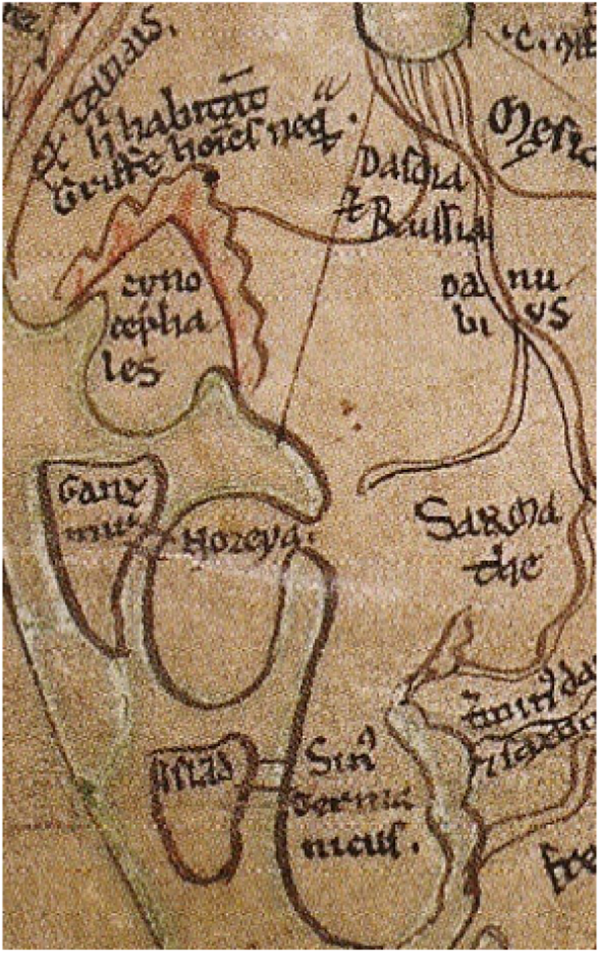
Figure 2. The two oval peninsulas, Sinus Germanicus and Noreya, and the connected islands Island and Ganzmir. In the vicinity is Cynocephales: Sawley map.
The influence of Old Norse can be detected on the Sawley map, which shows the word Norway in the vernacularised form Noreya. It is possible that the author of the map has combined some basic knowledge of Old Norse and Old English with rumours of an insular Scandinavia cultivated by the Carolingian and Anglo-Saxon geographical narratives.Footnote 15 The form Noreya is composed of the vernacular Noregr and the Old Norse toponymic element-ey, which could denote an island.Footnote 16 Ganzmir, the island connected to Noreya, appears with the same name on the Hereford map (c. 1300). The name might be a corruption of Canzia, Scanzia, Scania, Scandia or Scandza, all of them designating the southern-most province of present-day Sweden (Skåne). The connection between Scandinavia (Scanzia) and Norway (Norwegia) also appears on the ‘Lambert’ map in the Ghent codex (c. 1125). There, Scanzia is represented as a peninsula with narrow gulfs running up into Continental Europe on each side (see Figure 3).Footnote 17

Figure 3. Northern Europe on the Lambert map. Reproduced from Fridtjof Nansen, In northern Mists, 188.
From antiquity to medieval times, the coastal areas stretching from the east coast of Jutland to the river Vistula must have been known as the Sinus Codanus. Thus, Sinus Codanus may be the first Latin name for the Baltic.Footnote 18 According to Pomponius Mela (d. c. 45 ad), the Codanus Sinus is a ‘huge bay’ lying beyond the river Albis. In this large maritime space are located many islands. In Mela's description of Europe, Albis is the Elbe, which flows into the North Sea. The large islands could be the ones grouped in the south-west of the Baltic, stretching from Jutland to the Vistula (Funen, Samsø, Zealand, Lolland, Falster, Møn, Rügen, Bornholm and Öland). Scandinavia is seen not as a peninsula, but as the largest island of this archipelago. A variation of Scandza is Pliny's Scatinavia, which refers to the most famous island in the Codanus bay, beyond the mons Saevo (the mountainous part of Norway), which forms an enormous bay all the way to the Cimbrian promontory (Jutland).Footnote 19 This corresponds to Mela's Codanonia or Candanovia, described as the biggest and the most fertile island of the ones mentioned above, which integrates with its name the entire archipelago.Footnote 20
It is possible that Codanus was an archaic endonym that refers to the inner Danish waters seen as a river or bay. This is not the only time when an author used the term dana for a river. A first example is Procopius of Caesarea (c. 570 ad) who says that the river Po in northern Italy was also called Eridanos, because it begins in Celtic territory.Footnote 21 When he mentioned a Saxon attack in Gaul in the sixth century, Paul the Deacon (eighth century) used a second name for the French river Rhône (Rodanus).Footnote 22 The same name also appears on the Sawley map as a river which starts from the Alpes (Swiss Alps) and flows into the Mediterranean (see Figure 4). Most important is the name of the Danube, which appears on the map as Danubius. Therefore Codanus, used by Pliny and Mela, was not an original Latin term for the Danish sinus, but probably an Indo-European endonym.

Figure 4. The Sarmatians, Frisians, Allemannia, the cities of Cologne and Mainz on the Rhine, and the Rhône: Sawley map.
In contrast to the inhabited Christian world (orbis terrarum), the surrounding sea was often depicted as a large non-human realm, called alter orbis by Pliny. On the Sawley map, Sinus Germanicus was drawn not as a terrestrial region, but as a maritime space, that is, the Baltic. The Baltic islands marked on the map are considered ‘insulae extra orbem positae’ (‘islands placed outside the world’). This does not mean that the entire population on the islands was not Christian, or was isolated from the Christian oecumene. In some islands there may not have been a religious and secular administration, but only small communities of farmers and merchants.Footnote 23 Between the tenth and the late eleventh century, on some Danish southern islands such as Møn, Lolland and Falster, the pagan Wends (especially the Rugiani from Rügen) organised frequent raids. Along with the raids, the Wends started to colonise some of the islands. There were Wendic settlements on islands such as Lolland and Falster, where no stone churches were built and the main activity was reduced to agriculture. This is confirmed not only by archaeological research, but also by the local toponymy. On Falster were found the remains of a Wendish shipyard, while on Lolland some settlements retain until the present day the Slavic suffix -itze: Kramnitze, Tilitze, Kuditze, Bilitze.Footnote 24 The Wendish raids along with colonisation especially on Lolland and Falster must have been disturbing enough for the Danish king Valdemar i (1157–82), who organised a campaign on the island of Rügen in 1168. The political and religious centre, Arkona, was conquered, all idols were destroyed, and the Rugiani were forced to accept Christianity ‘according to the Danish rite’. The Rugiani were not fully pagans, but unorthodox Christians. They followed an aliena religio which was seen as a sort of apostasy combining aspects of Christianity with pagan superstitions.Footnote 25
On the Sawley map, the direct connection of the Baltic Sea with the location marked Island might be explained by the fact that from 1056 the Icelandic diocese of Skálholt was a suffragan of the archdiocese of Hamburg-Bremen. From about 1104 it became a suffragan of the new archdiocese of Lund and, from 1153, of Nidaros (Trondheim) in Norway.Footnote 26 By connecting Iceland to the Sinus Germanicus, the author of the map might have been emphasising the legitimacy of Hamburg Bremen in partes aquilonis in general and in Iceland in particular. The connection between Iceland and Sinus Germanicus could also be a trade route from Iceland to the main ports located on the shores of the Baltic Sea (see Figure 5). In Iceland, between the eleventh and twelfth centuries, economic centres were reduced to several fishing harbours and seasonal marketplaces. From the twelfth century, Arctic Norway was one of Europe's most important exporters of fish (cod in the form of air-dried stockfish). Iceland began to export preserved cod by the end of the thirteenth century.Footnote 27 Not only fish and homespun were exported from Iceland, but also mineral resources such as sulphur. The first evidence for Icelandic sulphur dates from the second half of the twelfth century. At that time, Bergen was the main port for goods coming from and going to various islands in the Atlantic which were under Norwegian political, economic and ecclesiastical influence (Shetland, Faroe, Iceland). After 1262, when royal rule was established in Iceland, the diocese of Nidaros already had the right to acquire sulphur. From that time onwards, not only Norwegians, but also English merchants started to export sulphur in large quantities.Footnote 28

Figure 5. Distribution map of the main market places from the eighth to the eleventh century in the coastal regions of the North and the Baltic Sea. Reproduced from Herbert Jankuhn, ‘Trade and settlement in central and northern Europe up to and during the Viking period’, Journal of the Royal Society of Antiquaries of Ireland cxii (1982), 18–50 at p. 36. © Royal Society of Antiquaries of Ireland.
The first mention of the name of the Baltic Sea (Mare Balticum) was made by the eleventh-century German chronicler, Adam of Bremen, who is quoting Einhard.Footnote 29 However, the origin of the word Baltic comes from Pliny, whose narrative included information derived from Xenophon of Lampsacus (d. 354 bc). In the first century, Baltia or Balcia (called Basilia by Pytheas) was seen as an island in the south-west of the Baltic, from which amber came. In his Natural history, Pliny wrote that ‘Xenophon of Lampsacus tells us that at a distance of three days' sail from the shores of Scythia, there is an island of immense size called Baltia, which by Pytheas is called Basilia.’Footnote 30
The medieval authors of mappae mundi made only limited use of the descriptions offered by Pliny, who mentions Scandia as being an island. These authors inherited the ancient idea of islands existing in the Northern Ocean which to them was terra incognita. In the eleventh and twelfth centuries, historians from Normandy included the island Scanza of Jordanes in the topography of Rollo's historical campaigns.Footnote 31 Through them, the image of Scandinavia as an island survived into the late Middle Ages when it was identified with Denmark, Norway or other northern lands. Mythological and geographical details were mingled and writers managed to offer a full image of a cultural space, with a string of meaningful interconnected historical events.
In a modern sense, a peninsula is a territory bordered by water on three sides and connected geographically to the mainland, with which it shares the same infrastructure. In the twelfth century, this connection was not so complex. For instance, the depiction of Norway as a peninsula was based on religious or economic affinity, and not on geographical details. This does not mean that the authors of world maps were completely devoid of geographical information. On the contrary, they used their basic geographical knowledge to describe certain territories and people, in various relationships with those who commissioned the writing of the manuscripts. If Norway were depicted as a peninsula connected to Scandinavia, it could mean that the author of the map highlighted an alliance between the Swedish and Norwegian monarchies. According to the historiography, King Knut i of Sweden (1172–95) and his jarl Birger Brosa (d. 1202) maintained good relations with the Norwegian king Sverre Sigurdsson (1184–1202). In 1185 Sverre married Margaret, Knut's sister and daughter of Erik ix (1156–60).Footnote 32
The reception of ancient Greco-Roman history and geography
The Sawley map, as other medieval mappae mundi, shows the tripartite world of Asia, Europe and Africa, encircled by the so-called ‘world ocean’. However this image reflects only some aspects of medieval oceanography. Medieval thinking relied heavily on the Bible. According to Genesis i.7, the ocean that encircles the earth is connected to the waters that were separated when God created the world and therefore are located above the celestial firmament.
The Sawley map belongs to a much wider family of spatial visual representations and ideas found not only in cartography, but also in architecture in both Western and Eastern Europe. Some examples can be found in the Byzantine churches, where the dome representing the heavens above the four directions of the earth (four angels) was often built above the intersection of the transepts and nave. Byzantine churches thus expressed the same symbolic spatial concept as the medieval world maps, namely a microcosm of earth and heaven.Footnote 33
Beside the geographical details of the Sawley map, there are some interesting symbols which needs to be discussed. The geographical details maintain a certain proportion and represent spatial point data with a symbol, whose area varies. The symbols used are circles, bars, squares or even pictographic symbols, all drawn in different colours. The methodology of proportional symbol on the maps has been discussed in detail by cartographers.Footnote 34 On the Sawley map seas are usually depicted in green, rivers in violet. Relief is represented by red lobed chains, while certain settlements appear as double towers, or ramparts.
The sizes and shapes of islands depended on non-geographic factors and therefore the authors of these world maps have tended to transform the image of space into a personal opinion about the world. There are scholars who suggests that this tendency could be used as a learning or memory tool for some special locations and therefore the world maps can be placed ‘within the medieval realm of wheels of memory’.Footnote 35
Places depicted at the centre of various medieval world maps are not monastic houses where the compiler of a map might live, but rather symbolic biblical centres. Jerusalem, the main biblical city, was not shown in the exact centre of the Sawley map, but above, on the right, framed in a vertical rectangle, and represented by an icon that appears to be a temple (see Figure 1). In the centre are other classical locations such as the sacred island of Delos. This was drawn as a large circle surrounded by the smaller islands of the Cyclades (see Figure 6). A similar depiction is the island named Orcades (the Orkneys), located in the north-west, between Sinus Germanicus and Britannia insula (see Figure 7). Both Scandinavia and Iceland as islands, and Norway as a peninsula, are clearly linked together as the main locations in the north, at a reasonable distance from the Orcades. All these locations that make up the northern European space are visibly linked to the territories of the Holy Roman Empire (for example, Saxony, where the archdiocese of Hamburg-Bremen is located).

Figure 6. The island of Delos surrounded by the Cyclades: Sawley map.

Figure 7. The Orcades depicted like the island of Delos, close to Frisia, Great Britain and Ireland: Sawley map.
Mela's Codanus is the ‘huge bay’ lying beyond the river Albis (the Elbe), which also flows into the North Sea. Therefore the author of the Sawley map does not call the bay Sinus Codanus (the Danish bay) but Sinus Germanicus, emphasising German ecclesiastical sovereignty over the Danish Church. From the middle of the tenth century until 1104, the diocese of Lund was a suffragan of Hamburg-Bremen. In 1104 Lund became an independent archdiocese, initially covering Denmark, Norway and Sweden. In 1154 the archdiocese of Nidaros (Trondheim) was founded, which included the Norwegian dioceses of Greenland, Iceland, the Faroe Islands, the Orcades (Orkney) and the Hebrides. In Sweden, the diocese of Sigtuna was symbolically transferred in 1130 to the former pagan centre of Uppsala, and in 1160 became an autonomous archdiocese of Sweden.Footnote 36
Between Sinus Germanicus and Orcades, in the west, is a square territory, which bears no name. Looked at closely it seems that Orcades is not depicted in exactly the same way as the Greek island of Delos. The first difference is related to the number of small circles drawn around the two islands. Delos has twelve circles, Orcades only nine. The second detail is that in the case of Delos, the circles are grouped at a similar distance from each other and from the large circle in the middle. In the case of Orcades, however, the circles are disproportionately grouped and at unequal distances from the main island. If Delos is placed in the middle of the sea, at a considerable distance from the mainland, Orcades is relatively close to the shore.
To the west of Orcades, at a distance somewhat similar to that of the two small peninsulas, there are two long, narrow islands of almost equal size. The first one is Britannia insula (Great Britain) and beyond it, Hibernia. What is interesting is that on the Sawley map, Hibernia, which is Ireland, is depicted as a kind of geographic doubling, placed in parallel with Britannia. Between them is a partially-erased drawing of lower clarity, symbolising another circular island, with two small circles on each side. This small circular island could be a previous placement of the Orcades, the Hebrides, the Isle of Man or the Faroes (see Figure 7). It is possible that the small circular island was erased because it was touched many times by those who consulted the map. Repositioning it at a larger size and indicating its name could underscore the religious importance that Orkney had for readers.
Contact with the Northmen and changing views of the other
The island of Delos may symbolise a geographic centre of the world, which transferred the identity of the ancient Hyperboreans who live ‘beyound the north wind’ (Boreas) to the Scandinavians, Celts, or Anglo-Saxons.Footnote 37 However a major problem that ancient Greek authors faced when it came to Hyperborea was its location. Hyperborea was not a real physical location which could be reached by sailing or walking, but rather a mythical realm with a symbolic identity. The mystery about the location of this realm also intrigued Greek authors, starting with the Homeric period. As the etymology of the name suggests, the location of Hyperborea was related to the identification of the northern wind, Boreas. Many of the Greek writers who lived between the eight and fifth centuries bc first located Hyperborea in Thrace or north of Mount Haemus, in present day Romania, or above the Caspian Sea.Footnote 38 For some Greek writers, Hyperborea was seen as a land that should be explored with the help of the human mind. This was largely due to the fact that they had limited geographical knowledge. They did not deny the existence of a land that they had never visited and about which they had heard only rumours, but tried to describe it in literary terms. They used information from the Homeric period about Greek mythology, which they interpreted according to the context of the time. Perhaps the most relevant example in the Classical period is the poet Pindar (c. 518–438 bc) who, in his account of the visit of Perseus to Hyperborea, stated that ‘neither by ship nor going on foot’ could someone find ‘the marvellous road to the meeting-place of the Hyperboreans’.Footnote 39
For Roman writers who lived between the first and the third centuries ad, Aquilo, the equivalent of Boreas, blew from the North Sea and the North Atlantic Ocean. However, a clearer identification of the Northmen with the Hyperboreans took place with the help of late antique Byzantine scholars. In their writings they elaborated a sort of Delphic fairy-tale and moved Hyperborea ever farther away to Scandinavia. A relevant example might be Procopius, who substituted for the name of Scandia that of the legendary island, Thule. This literary tradition was acquired by medieval Latin-speaking authors during the high Middle Ages. The identification of the Northmen with Hyperborea and Thule did not disappear in Byzantium either. In the Alexiad, written in the mid-twelfth century, the Byzantine princess Anna Comnena (1083–1153) placed Thule at the North Pole, where the Vikings originated.Footnote 40 Much later, Johannes Bureus (1568–1652), royal librarian and adviser to Gustavus Adolphus of Sweden (1611–32), claimed that the ancient wisdom of the Hyperboreans was preserved in the runic alphabet.Footnote 41
In the geographical relocation of places of historical significance, religion played an essential role. Adam of Bremen was the first author to connect Northern history and geography to Christian rhetoric. The genealogy of the Northmen, described as ‘barbarians’, goes back to Carolingian tradition about the Saxon wars. Later, this label was inherited by the new Christians (Saxons as well as the Scandinavians) and applied to other pagans from the Baltic region like the Wends. Adam's work seems to be a compilation of texts from the Bible, Roman historians and geographers (Sallust, Martianus Capella, Solinus), classical poets (Vergil, Horace, Lucan), early Christian authors (Orosius, Bede), Frankish writers (Einhard, Gregory of Tours), the annals of monasteries (Fuldenses, Corbienses) and the hagiographies of Ansgar, Willehad or Rimbert.Footnote 42 On the Sawley map, in the Mediterranean, at the tip of Italy, is the head of a barking dog bearing the inscription Scylla. Below are six circular drawings. Above Scylla, not so far from Sicilia, is another drawing representing a mythical sea creature named Charybdis, as can be seen from the inscription beneath it (see Figure 8). In Greek mythology, Scylla is a female sea monster, with six dog's heads ringing her waist. She was well known for her ferocity, attacking passing ships and seizing sailors with each of her heads. Over time, the place where Scylla dwelled has been associated with the Strait of Messina between Italy and Sicily.Footnote 43

Figure 8. The head of the barking dog at the tip of Italy: Sawley map.
We know that in most of the medieval world maps, the central position of Jerusalem as a sacred location made possible the spread of its holiness to neighbouring lands. The model was taken from the holy island of Delos, the symbol of spirituality in ancient Greece. If we go further to the edge of the map on the left, we have the terra incognita, which has an extreme climate and usually is inhabited by monsters, legendary animals and exotic peoples.Footnote 44 The wild nature of the north is manifested not only because of the extreme cold weather but also because of the customs of peoples inhabiting it. Perhaps the most famous inhabitants are the Amazons, who are placed in Amazonia outside a high mountain range. Inside it is Hyrcania, a historical region to the south-east of the Caspian Sea which over the centuries belonged to several empires, Median, Achaemenid, Seleucid, Arsacid and Sasanian. According to Pliny, the Amazons lived in the valley of the River Terme, on the southern coast of the Black Sea. A little below can be seen the toponym Mare Cimericum (Cimmerian Sea), also known as the Bosporus, and the Straits of Kerch. Beyond the Cimmerian Sea there is Albania. Across a long river are the Anthropophagi, an ancient tribe of cannibals located by Pliny beyond the Borysthenes (Dnieper), in northern Scythia (see Figure 9). Geographical, cultural and religious details were highlighted in colour so that they could be more easily read. Red is the colour that has been best preserved, and can be found in drawings that represented mountains, cultural and religious boundaries, or various mythological descriptions. For instance, close to Borysthenes is a red inscription Terminus Asie et Europe, which emphasises the border between Asia and Europe. Beyond a mountain range there is the same red inscription and then the river Don (Fluuius Tanais). West of it, after the land of the Gryphons (‘Hic habitant Griffe, homines nequam’), embraced by another mountain range, are the Cynocephales (see Figure 2). They are depicted in a near-identical location on the Hereford map.

Figure 9. The Amazones and the Anthropophagi: Sawley map.
According to Adam of Bremen, the Amazon women lived in terra feminarum, on the eastern shores of the Baltic Sea. The ‘women's land’ is located close to Estonia and the island of Björkö (Birka), the Viking Age trading centre where goods from Finland and Scandinavia could be found. Not far away, in the territory of Kievan Rus’, live their male offspring, the Cynocephali. On the Sawley map, they are located in the vicinity of Dascia et Russia (Dacia and Russia). The inhabitants of the neighbouring realm, called Albania, are, according to Adam, the Alani or Albani, who, in their own language are called Wizzi.Footnote 45 Given these reports, the realm inhabited by Cynocephali would be the easternmost arm of the Baltic Sea, that is, the Russian territory with access to the Gulf of Finland and Lake Ladoga. The Wizzi of Adam are the Wilzi or Lutici, a Wendish tribe located between the Warnow and the Oder rivers, up to the Peene. For Adam, Gotland is an island that has no religious significance, but rather an economic one, due to trade across the Baltic Sea and the status of competitor to Birka. The German author placed it geographically correctly, near Scania (Skåne) and Gothia (Götaland), and not in the vicinity of the British Isles, as Orcades appears on the map.Footnote 46
The sacrality of Delos has its origins in Greek Olympian mythology. On the Sawley map, both Orcades and Delos are surrounded not by other smaller islands, but by dog-heads (Cynocephali) (see Figure 2). In Greek mythology, there are patterns in which dogs are closely related to commerce and the gods. Delos was considered a sacred island first because it was the birthplace of Apollo and his sister, Artemis. Second, the island hosted several sacred locations which had religious (sanctuaries, often placed on top of the mountains) and economic functions (ports). It is likely that one of the main sacral symbols of Apollo and Artemis was the dog, and the wolf. In the Greek myths, Artemis and Apollo were born in Delos, on a mountain named Kynthos which includes the dog-stem. The sanctity of the two spread to surrounding Greek cities. For instance in Argos, Apollo was called Lykios or Lykeios, which could be translated as ‘wolf’. In a hymn to Artemis, one of her epithets is skylakitis, ‘protectress of dogs’. At Brauron, a deme of ancient Attica, her priestesses celebrated a festival called hieron kynegesion, ‘festival of the dog establishment’.Footnote 47
The dog and the wolf, as sacral symbols for Apollo and Artemis, shared similar attributes, such as loyalty, trust, strength in battle, but also revenge, ferocity and cruelty to enemies. These attributes proved to be useful tools for medieval Christian authors when describing certain people outside the Christian community. The Cynocephali were ultimately derived by medieval authors from the work of Julius Solinus, the third-century adaptor of Pliny's Natural history. Therefore, the identity of non-Christians was constructed by the missionary writers whether by persuading many of the utility of Christian identity or by assimilating pagans to Christian identity by military means. In some medieval world maps the Cynocephali, for example, were associated not only with the Northmen (heathens or Christians), but also with unbelievers like Muslims.Footnote 48 The Cynocephali are first located in the extreme north in the seventh-century Cosmography of Aethicus Ister, who argued that the cynocephalic St Christopher (d. c. 251) came from such a race. Cynocephali are also located in the north in some later world maps such as that of Beatus (d. c. 800), the Hereford map (c. 1300) and the works of the Persian geographer, astronomer and physician, Zakariya al-Qazwini (d. 1283).Footnote 49 In Gesta Caroli Magni, Notker the Stammerer (d. 912) stated that the term cynocephali was used by Charlemagne to describe the Northmen,Footnote 50 known for their sporadic brutal attacks on the island of Lindisfarne in the ninth century. An interesting case is that of Ratramnus (d. c. 868), a Frankish monk of the Benedictine abbey of Corbie, who was concerned about the possibility of encountering the Cynocephali in his travels to the North. His records are also relevant because he highlighted the human origin of Cynocephali, giving the term a pejorative meaning. Furthermore he saw them as being not mythical creatures, but rational humans who domesticated animals.Footnote 51
As the world evolved, through exploration, evangelisation and trade, the dog-headed men would come to be located in ever more obscure and unknown regions related to some ecclesiastical centres. Cynocephali were seen as a separate gens from all other Christian populations. Thus the link between disobedient subjects and dogs was used in the context of the religious and political apostasy of the Wends, who, like the Danes, killed Christians. In northern Europe, the fidelity of some populations to the Christian secular and ecclesiastical power consisted in the payment of tribute and tithing. This functioned as a kind of law that decided the religious status of those tributary populations.Footnote 52 The Wendish uprising starting in 983, led by the Obotrite prince Mstivoj, had less to do with pagan resistance and more with the refusal to pay the tribute, although rebellion against the Saxon nobility was also without doubt a rejection of the Christian faith. Mstivoj was not really a pagan. Prior to the uprising he would have received at least the sign of the cross, and possibly aspersion with holy water from a priest, probably Bishop Wago of Starigard/Oldenburg (974–83), a theological procedure which may have indicated entry into the catechumenate by an unbaptised person, over whom prayers would have been read in order to drive away the devil.Footnote 53 This could be explained by the fact that on the eve of the uprising, Dietrich of Haldensleben, the Margrave of Nordmark (965–85), opposed marriage between the Obotrite prince and a niece of the Saxon duke, Bernard i (973–1011). The margrave claimed that ‘it is only right that the high-born niece of a great prince should be married to a man of exalted rank and not, indeed, be given to a dog’.Footnote 54 This is not a singular case. The early eleventh-century German chronicler, Thietmar of Merseburg, called the Wilzi/Lutici ‘greedy dogs’ (‘avaris canibus’), because they attacked the diocese of Brandenburg, and killed its bishop, Dodilo (968–80).Footnote 55 Another association between Cynocephali and a northern population was made by the missionary bishop and martyr, Bruno of Querfurt (d. 1009). In some of his accounts of the martyrdom of St Adalbert (d. 997), the pagan Prussians were described as having dogs’ heads (‘capita canum’).Footnote 56
Christian identity formation and sacred places
The Sawley map is oriented to the east: the words Oriens and Paradise can be seen at the top. The oval map is graced with four angels in each corner which emphasise the apocalyptic events preceding the Last Judgment. In Christian eschatology, the four angels symbolise the nations which are in the four corners (winds) of the earth and they appear after the Lamb has broken the sixth seal.Footnote 57 In the Book of Revelation (xx.7–10) it is stated how Satan is to be imprisoned for a thousand years, and how, on his release, he will gather ‘the nations in the four corners of the Earth, Gog and Magog’ to a final battle with Christ, his saints and angels (see Figure 1).Footnote 58 The compiler of the map may thus be looking forward to the Apocalypse and Christian judgement, emphasising the end of space and time, when there would be no need for geographers and any kind of maps where certain locations were linked. Furthermore the angel in the upper left corner points a finger at the red square, inside which the names Gog and Magog appear.
Over the next centuries, when the doctrine of the holy war took more effect in the north, this apocalyptic battle also involved military orders. A miniature from Heinrich von Hesler's (1322) Apocalypse shows the German knights of the Teutonic Order in the battle against the evil Gog and Magog (Württembergische Landesbibliothek, Stuttgart, HB XIII 11, fo. 153v).Footnote 59 The manuscript is considered one of the most important primary sources regarding the ideology of the order and the concept of Christian kingship in the first part of the fourteenth century. The author, also a member of the order, presents the struggle of the knights against the enemies of the German Church, which took various forms (pagans in Prussia and Lithuania, Jews, Orthodox, possibly supporters of the papacy, various rebels, etc.). It is an eschatological vision influenced by the Sibylline books, in which the victory of the last Roman emperor against Gog and Magog and the forced conversion of the pagans and Jews appears. In the battle with his enemies, the emperor (possibly the one from the miniature) is assisted by knights; he appears as the legitimate ruler of the two worlds (temporal and spiritual). If the Teutons had been represented in their traditional clothes, they would have been likened to the Templars or other orders obedient to the papacy.
By the twelfth century, Jerusalem was seen not only as the centre of the world but also as the heart of spirituality and a sacred destination of humanity, just like Delos was in ancient Greece. Medieval world maps show various regions as of different natures and therefore their intentions are to transmit hidden knowledge conveyed in biblical quotations. The author of the Sawley map appears to have had strong eschatological expectations, since he uses a religious name for an island depicted in a similar way to Delos, the holy birthplace of Apollo the Hyperborean and one of the traditional Greek centres of the world. The author's audience thus included those who looked to the future in an eschatological manner.
During the second half of the sixth century, the Orkneys, inhabited at that time by the Picts, were targeted by the Celtic missionaries guided by St Columba (d. 597).Footnote 60 In the ninth century, the Vikings from Norway invaded the islands and made them the headquarters of their expeditions against Scotland and England. The Norwegians continued to control the islands until 1468, when they finally passed to Scotland.Footnote 61
Between the ninth and tenth centuries, most of the clerical writings regarded the Viking invasions in Britain and Ireland as being a divine retribution. The wild Vikings may therefore come from a terra incognita inhabited by Cynocephali, like the Orcades. This perception of the Northmen is confirmed by a ninth-century tombstone from Lindisfarne which seems to depict the Viking attack of 793. The tombstone was erected over the grave of a victim of one of the Viking raids on the island in which its monastery was destroyed. A Last Judgement is carved on the other side.Footnote 62 Therefore, on the Sawley map, the Orcades appear close to Britannia insula and Hibernia and have a direct navigable corridor showing what the Scandinavian world meant to the author (see Figure 7).
The symbolic attributes of sacrality are closely related to the imaginary. In this case, Cynocephali are not Christian Scandinavians, but the pagan Vikings who frequently attacked Christian lands. They were therefore depicted separately and placed very close to Scandinavia, in a peninsula which could be Jutland. On a runic stone in Jelling (central Jutland), the royal seat of the first Danish kings, the name Denmark appears for the first time. The stone was placed in about 950 by King Gorm the Old in memory of his wife, Thyra. Gorm (‘Worm’ in Latin) is described by Adam of Bremen as a ‘savage worm’ (‘crudelissimus vermis’), because he was ‘hostile to the Christian people … set about to destroy Christianity in Denmark, driving out priests of God from its bounds and also torturing very many of them to death’.Footnote 63
Northern Europe was seen not as a marginal area, but rather as a mental periphery, in contrast with the Christian oecumene. During the twelfth century the connection between ancient mythology and theology was common. Often, the construction of Christian identity took place to some extent on the skeleton of Greco-Roman history and mythology. This is obvious, since the Greco-Roman world was the fertile ground upon which the Christian faith sprouted and spread. In other words certain myths and legends had not been separated from reality in medieval Christian thought. Of course, this complex mechanism varied depending on the political and economic context of the time. Some attributes of ancient gods were assimilated by Christian writers and used as tools in the construction of a Christian identity. Superstitions were easier to follow than the teachings of the Church. This was common in the northern regions, which did not have a long Christian history. This measure had the role of both strengthening the fragility of Christian faith in the northern dioceses, and emphasising the ecclesiastical authority of the archdioceses to which they were subordinated.


