


1. INTRODUCTION
The Indian government has planned to develop an independent and autonomous regional navigation system called IRNSS, which has been under development by the Indian Space Research Organization (ISRO) since 2006. The space segment of the proposed IRNSS consists of seven satellites. Among them three will be geo-stationary orbit satellites (GEOS) and four will be geo-synchronous orbit satellites (GSOS). The satellite launches will start in 2010 and by 2011/2012 the system is expected to be fully operational (http://isro.gov.in). The targeted position accuracy is better than 10 m over a region extending to the geographical boundaries of India and 1500 km beyond (Suryanarayana Rao, Reference Suryanarayana2007). The entire IRNSS system will be under Indian control. The space segment, ground segment and user receivers will be built in India (www.isro.org/pressrelease/Jul04_2006).
To achieve precision approach, IRNSS can be augmented with pseudolites. A pseudolite can be considered as a satellite-on-the-ground that transmits GPS-like ranging signals. It transmits a signal with code-phase, carrier phase and data components with the same timing and format as the GPS signal (Parkinson and Spilker, Reference Parkinson and Spilker1996). A GPS receiver acquires this signal and derives pseudorange for navigation.
In this paper, the feasibility of augmenting IRNSS using pseudolites is investigated. DOP values due to standalone IRNSS are estimated over various regions of India. Subsequently, a typical Local Area Augmentation System (LAAS) scenario is considered with APLs (Airport Pseudolites) over the Hyderabad region. The effects on DOP due to augmentation of IRNSS with APLs and/or GPS are investigated. Data acquired from a DL-4 plus GPS receiver is used for the analysis.
2. PROPOSED ARCHITECTURE
The proposed architecture of the IRNSS consists of space, ground and user segments (Figure 1). The ground segment consists of a Master Control Centre (MCC), IRNSS Ranging and Integrity Monitoring (IRIM) stations and IRNSS telemetry and command stations. The function of the MCC is to estimate and predict the ephemeris of satellites, make clock and ionospheric corrections and provide integrity. The function of IRIM stations is to receive data and ranging information from the GEOSs and GSOSs and then transmit the data to the MCC. IRIM stations will be located at 20 places in India. The function of telemetry and command stations is to receive telemetry from the IRNSS constellation and uplink navigation data updates. For higher accuracies, the system can be augmented to cover local areas (Arjun Singh and Saraswati, Reference Singh and Saraswati2006).

Figure 1. Proposed IRNSS architecture.
The IRNSS system will provide dual frequency (S and L 5 band) usage. At present one downlink in S-band and three downlinks in L 5 band are planned (Suryanarayana Rao, Reference Suryanarayana2007). Bit rate of the navigation data will be 50 bps. The signal structure will be Code Division Multiple Access (CDMA) with the navigation data spread over the ranging codes (http//:sidt.gpsworld.com).
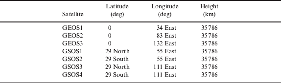
The proposed IRNSS space segment is a constellation of seven satellites. Of these, three will be placed in geostationary Earth orbit (GEO). The proposed locations for GEO satellites are at longitudes 34° E, 83° E and 132° E (Figure 2). Figure 2 also shows the remaining four satellites (at a particular instant) which will be placed in geosynchronous Earth orbits (GSOs). The orbits will be at an inclination angle of ±29° with respect to the equator. The proposed longitudes for these satellites are 55° and 111° East. Table 1 shows the coordinates of IRNSS satellites (http://isro.gov.in).

Figure 2. Proposed locations of IRNSS satellites.
Table 1. Co-ordinates of proposed IRNSS satellites.
3. REGIONAL EFFECTS OF IRNSS ON DOP
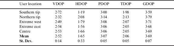
Using the proposed coordinates of seven IRNSS satellites, DOP is estimated. To take advantage of all the available SVs an ‘all-in-view’ method is used. DOPs are estimated for five locations of the user within the Indian region and the regional effect on DOPs is investigated. The Indian region lies approximately between latitudes 8°–35°N and longitudes 70°–90°E. The first user location is selected at the northern tip, second at the southern tip, third at the extreme west, fourth at the extreme east and the fifth at the centre of India. The geodetic height is assumed as 500 m (MSL) for all the locations (Table 2). The respective DOP values are shown in Table 3. For all the locations, Vertical DOP remains less than or equal to 2·72. Horizontal DOP ranges from 1·19 to 2·08. In all locations, Position DOP is around 3, Time DOP is approximately 2 and Geometric DOP is around 3·69. As the DOPs remain almost constant everywhere, the respective mean values are almost the same as the individual values of DOPs. Standard deviation is negligible for all the DOPs.
Table 2. Co-ordinates of assumed user locations to estimate DOPs due to IRNSS.
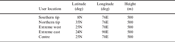
Table 3. Estimated DOPs for the assumed user locations.
4. AUGMENTATION OF IRNSS WITH PSEUDOLITES
IRNSS can be augmented with pseudolites for local area navigation. The feasibility of using pseudolites for an Indian LAAS is investigated by considering an aircraft in a LAAS scenario (Figure 3). The elevation angle (θe) of the pseudolites and IRNSS satellites depends on the glide slope and the distance of the aircraft from the pseudolites/GEOS/GSOS. It is assumed that the aircraft is equipped with two top antennas and one bottom antenna. One top antenna receives VHF signals from the DGPS station and the other top antenna receives signals from IRNSS/GPS. The bottom antenna receives pseudolite signals (Cohen et al, Reference Cohen, Pervan, Cobb, Lawrence, Powell and Parkinson1993).

Figure 3. Augmentation of IRNSS with airport pseudolites (APLs).
It is assumed that the aircraft approaches (making an angle of) the runway touchdown point on the glide path with a 3° glide slope (Fukushima et al., Reference Fukushima, Yoshihara and Suga2004). Further, it is assumed that the horizontal coverage is 20 nm (37·04 km). This leads to a maximum altitude of 1·94 km just before the aircraft enters the glide path. Also, it is assumed that two pseudolites (APL1 and APL2) are placed perpendicular to the runway, 6·5 km away from the touchdown point. A third pseudolite (APL3) is positioned at 6·5 km from the touchdown point in the direction of runway.
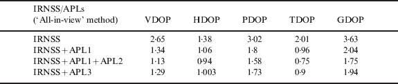
Various configurations with different APLs/GEOS/GSOS geometries are considered to investigate their effect on DOPs. The user is assumed to be in the Hyderabad region. Initially, DOPs due to standalone IRNSS were estimated. Subsequently, the IRNSS constellation data was augmented with simulated coordinates of APLs to investigate the effects on DOPs. Three scenarios are considered with APLs. In the first scenario, IRNSS is augmented with APL1. In the second APL1 and APL2 are used for augmentation and in the third APL3 is used. The ‘All-in-view’ SVs method is implemented to estimate and compare the DOPs. Coordinates of APLs and user are shown in Table 4. Table 5 shows the estimated DOP values for standalone and augmented IRNSS. DOPs due to standalone IRNSS have the highest, and IRNSS augmented with APL1 and APL 2 the lowest.
Table 4. Simulated coordinates of APLs and user.
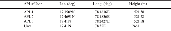
Table 5. DOP values due to IRNSS and augmented IRNSS (‘All-in-view’ method).
5. AUGMENTATION OF IRNSS WITH GPS
IRNSS can also be augmented with GPS (Suryanarayana Rao, Reference Suryanarayana2007). In this section the effect of augmenting IRNSS with GPS is investigated. Data acquired from a DL-4 plus GPS receiver is used for the analysis. The DL-4 plus is a high performance, high accuracy, dual frequency GPS receiver. It is capable of receiving and tracking L 1 C/A code, L 1 and L 2 carrier phase. It is a 12 channel receiver and can track a maximum of 12 satellites. Convert4 software is supplied with it to convert the incoming data in RINEX format (DL-4plus User manual, 2005).
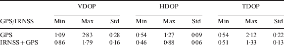
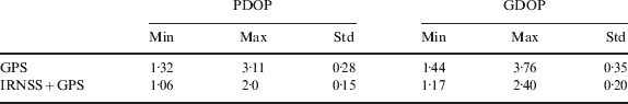
The IRNSS satellite coordinates given in Table 1 were used for analysis. Figure 4 shows the variations in GDOP over a 24 hour period for standalone GPS and IRNSS augmented with GPS. GDOP is higher due to standalone GPS (3·76 max) compared to that of augmented IRNSS (2·40 max). Plots of PDOP, VDOP, HDOP and TDOP using standalone GPS and IRNSS augmented with GPS show similar tendencies. Table 6 shows minimum, maximum and standard deviation of DOP values for the two cases. Minimum, maximum and standard deviation of DOP values due to standalone GPS are higher. When IRNSS is augmented with GPS, these values are reduced.

Figure 4. Variations in GDOP due to GPS and IRNSS augmented with GPS.
Table 6. Minimum, maximum and standard deviation values of DOPs due to GPS and augmented IRNSS.
6. AUGMENTATION OF IRNSS WITH GPS AND PSEUDOLITES
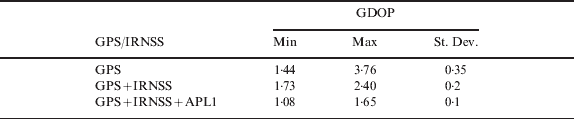
To investigate the feasibility of augmenting IRNSS with GPS and pseudolite, a typical LAAS scenario was considered with one APL. GPS data obtained from a DL-4 GPS receiver was used for the analysis. GDOP values due to IRNSS augmented with GPS as well as with APL1 are estimated and plotted in Figure 5. It is observed that GDOP is always highest (3·76 max) if only GPS SVs are considered. When IRNSS is augmented by GPS the GDOP values are lowered (2·4 max). When APL1 is included in augmentation GDOP values are further reduced (1·65 max). Table 7 shows the minimum, maximum and standard deviation of GDOP due to the three cases. The performance of IRNSS augmented with GPS proves to be better than that of standalone GPS. The values of GDOP due to IRNSS augmented with GPS as well as pseudolite (APL1) prove to be the best.

Figure 5. Augmentation of IRNSS with GPS and pseudolites.
Table 7. Minimum, maximum and standard deviation of DOPs due to GPS and IRNSS augmented with GPS and pseudolites.
7. IMPLEMENTATION ISSUES FOR IRNSS
An ordinary GPS receiver cannot be used for tracking all IRNSS signals without significant hardware and software modifications. An IRNSS receiver is supposed to track all GNSS satellites as per plan (Suryanarayana Rao, Reference Suryanarayana2007). However, the varying frequencies of GNSS (L-band only) and IRNSS (S and L-band) will compel hardware modifications. IRNSS signals have to travel from GEO and GSO to Earth whereas GPS signals travel from MEO to Earth. Hence the propagation errors introduced in the signals will not be identical and consequently their mitigation techniques need to be different. In addition, augmenting IRNSS with ground based pseudolites will require care. The power received due to GEO and GSO satellites will be less than that from MEO satellites (i.e., GPS SVs) and will be very much less than the power due to nearby transmitting pseudolites. Hence, the receiver dynamic range should be sufficient enough to accommodate all three types of signals. Due to the elevated constraints on the dynamic range of the receiver, the near-far problem could become crucial. Multipath effects can be reduced by shaping the receiver antenna radiation pattern (Martin, 1999).
8. CONCLUSIONS
In this paper the regional effect on DOPs is investigated by assuming users at five different locations in the Indian region. It is found that GDOP values remain almost constant for these locations. The mean values of DOPs are estimated as 2·52 (VDOP), 1·65 (HDOP), 3·08 (PDOP), 2·07 (TDOP) and 3·69 (GDOP). The respective DOP values are approximately constant as the satellites are stationary (geo-stationary) with respect to the user and hence form a constant unvarying geometry of constellation. IRNSS is augmented with simulated coordinates of APLs. Due to augmentation with two APLs, GDOP is reduced to 1·75 (max) from 3·63 (max) of standalone IRNSS. Further, IRNSS is augmented with GPS. GDOP due to augmentation is reduced to 2·4 (max) from 3·76 (max) of GPS constellation. Also IRNSS is augmented with an APL as well as with GPS. As a result GDOP is further decreased to 1·65 (max).
ACKNOWLEDGEMENTS
The work presented in this paper is carried out under the project sponsored by Dept. of Science and Technology (DST), New Delhi. Vide sanction order No: SR/S4/AS-230/03, dated: 21-03-2005.


