


Makeshift ornamentation
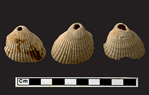
Five matching perforated freshwater mussel shells (Unio spp.; see Figure 1) were found together during the excavation of a later Bronze Age settlement at Striplands Farm, Longstanton, Cambridgeshire (Evans & Patten Reference Evans and Patten2011). The site lay well inland on a clay and gravel terrace-edge 10km north-west of Cambridge, 5km from the Great Ouse and 10km from the River Cam, the two nearest major river valleys (Figure 2). In addition to a handful of earlier Beaker (c. 2400–2000 cal. BC) and Deverel Rimbury (c. 1600–1200 cal. BC) sherds, it yielded an impressive assemblage of Late Bronze Age pottery (c. 4150 sherds), and radiocarbon dates from the site fell between the twelfth and ninth centuries cal. BC. The site's various posthole settings included at least two roundhouses, but the most characteristic components were a series of deep waterlogged wells. Not only did the latter produce the bulk of the small finds and a wealth of organic artefacts, they are also the very features that enabled colonisation of such an ‘inland’ locale in the first place; the securing of a regular water supply in such off-river situations obviously being paramount. It was from the basal fill of one of these features that the mussel-shell necklace assemblage was recovered.

Figure 1. Shell necklace finds: right) Striplands Farm, Longstanton freshwater mussel shell setting; below) Thorney Borrow Pit's perforated cockle and whelk shells (with the latter's find-spot indicated left; Mudd & Pears Reference Mudd and Pears2008: fig. 2 & pl. 12).

Figure 2. Location of sites tracing the sea (top): 1) Striplands Farm, Longstanton; 2) Upper Delphs, Haddenham; 3) Barleycroft Farm/Over; 4) Colne Fen, Earith; 5) Block Fen, Mepal; 6) Fengate/Flag Fen and Must Farm; 7) Eye Quarry; 8) Briggs Farm, Thorney; 9) Pode Hole/Tower's Fen/Bar Pastures, Thorney; 10) Nine Bridges, Northborough; 11) Welland Bank; 12) Langtoft; 13) Billingborough; 14) Redgate Hill; 15) Holme-next-the-Sea (see text for specific site references and, otherwise, Knight Reference Knight1998, Chowne et al. Reference Chowne, Cleal, Fitzpatrick and Andrews2001, Pickstone & Mortimer Reference Pickstone and Mortimer2011 and summaries in Evans et al. Reference Evans, Beadsmoore, Brudenell and Lucas2009: chap. 2; see also Gurney Reference Gurney1980, Lane & Morris Reference Lane and Morris2001: 8–9). The sea's inland progression from the later Neolithic to the earlier/Middle Bronze Age (after Waller Reference Waller1994) (below).
Comparable necklace settings of somewhat earlier date are known from farther north along the west-central fen-edge and have been associated with Middle Bronze Age fieldsystems. These settings are seashells, however, rather than freshwater shells. Seven perforated cockleshells (Cerastoderma edule), together with a ‘holed’ whelk (Buccinum undatum), were recovered from one of the ditches at Thorney Borrow Pit, east of Peterborough (Figure 1; Mudd & Pears Reference Mudd and Pears2008: 71). A similar find was discovered during excavations at Baston Quarry, Langtoft, in south Lincolnshire. Here, a waterlogged well, along with quantities of Deverel Rimbury pottery and a log ladder, yielded three perforated cockleshells (Figure 3; Hutton Reference Hutton2008).

Figure 3. Ditch-end sea-mussel deposit (top) and perforated cockleshell-necklace (below) from Baston Quarry, Langtoft, Lincolnshire (see Figure 4 for location; photographs by D. Webb, Cambridge Archaeological Unit).
Thorney Borrow and Langtoft Quarry are today located more than 35km inland from the coast. The seashell necklace settings, however, are not entirely unexpected, as during the Bronze Age both would have been close to saltmarshes fringing the region's former embayment of the North Sea (Figure 2). This is documented by the extent of the marine fen clay beds (Waller Reference Waller1994). Indeed, quantities of briquetage have been recovered from these sites and from a number of other contemporary settlements close to the west-central fenland's former shoreline (Figure 2). These were all located on ‘solid’ gravel terraces and would have lain some kilometres from the sea proper; the intervening swathe of land was occupied by saltmarshes crossed by a myriad of tidal creeks (i.e. a ‘fluid landscape’; Lane & Trimble Reference Lane and Trimble2010, 362–65, figs 6, 168 & 169).The field system and settlement at Thorney are typical of the majority of these sites, insofar as the economic and environmental evidence shows little direct indication of the sea's proximity. All that could attest to nearby brackish conditions were slightly enhanced Chenopodiaceae pollen counts, two possible fragments of cockle and sea-mussel shell, a few shells of Hydrobia ulva and H. ventrosa in the snail assemblage and the presence of two beetle ‘type-markers’ (Paracymus aenus and Ochthebius marinus; Rackham in Daniel Reference Daniel2009: 159).By contrast, investigations at Langtoft have now produced substantial marine shell assemblages. In addition to the marine snail Hydrobia ulva, the common or blue sea mussel (Mytilus edulis) occurs, and, in one case, its shells had been dumped in a ditch terminal (Figures 3 & 4; Hutton Reference Hutton2008: 24; de Vareilles in Hutton & Dickens Reference Hutton and Dickens2010: 23–24). The marine snail lives on seaweed and thus hints of that sea plant's utilisation, and Langtoft is in fact one of the very few prehistoric sites in the region to have such evidence (see also Murphy Reference Murphy2009, 27–31 & 49–51).

Figure 4. Plan of Baston Quarry, Langtoft, Lincolnshire: top) cremation cemetery with cockleshell-accompanied interments indicated; below) a portion of its Middle Bronze Age field system with the location of sea-mussel finds and cockleshell necklace indicated (N.B. the Outgang Road sub-site, with its Iron Age saltern, was excavated previously by Archaeological Project Services; see Lane & Morris Reference Lane and Morris2001: 250–62).
More dramatically attesting to the nearby presence of the sea was the recovery of the pelvic bone of a grey seal at Welland Bank settlement (Albarella & Viner nd). Marine exotica have been recovered from other prehistoric sites in southern Britain. These range from a dolphin vertebra in a Grooved Ware pit at Redgate Hill, Hunstanton (Bradley et al. Reference Bradley, Chowne, Cleal, Healy and Kinnes1993: 64), to a heap of cockleshells reportedly within a Beaker grave at Southchurch, Essex (Clarke Reference Clarke1970: 444 & 481) and a great white shark's tooth associated with Late Bronze Age midden deposits in Llanmaes, Vale of Glamorgan (Gwilt & Lodwick Reference Gwilt and Lodwick2009). Yet, as far as can be established, the shell-only necklaces described here are unparalleled in the Middle and later Bronze Age of southern Britain. Seashells do feature in a few Early Bronze Age necklaces, such as periwinkles at the Shrewton Barrow burial (Green & Rollo-Smith Reference Green and Rollo-Smith1984), but most of these are fossil shells, akin to the scaphopods from the Thomas Hardye School Site in Dorchester (Gardiner et al. Reference Gardiner, Allen, Powell, Harding, Lawson, Loader, McKinley, Sheridan and Stevens2007: 41 & 52). Recent findings are the seashell disc-beads in an otherwise jet and amber bead Early Bronze Age necklace from Great Cornard, near Suffolk (Demarchi et al. Reference Demarchi, O'Connor, Ponzoni, Ponzoni, Sheridan, Penkman, Hancock and Wilson2014); here, it needs also to be acknowledged that some of the amber found in Bronze Age contexts may have been derived from the North Sea shore of Britain, rather than from the Baltic (Beck & Shennan Reference Beck and Shennan1991).
Conjuring up images of a Bronze Age replete with shell necklaces can make the period seem ‘different’ in almost an anthropological manner, with Polynesia perhaps no longer seeming quite so distant. Yet these shell(-only) necklaces evidently interacted with a range of other personal ornaments (see Roberts Reference Roberts2007), which include an array of fairly humble items now widely recovered from burials, such as single amber beads, shale ear-studs and perforated animal teeth (Evans et al. Reference Evans, Brudenell, Patten and Regan2013: 82). These can only rank as modest personal- or group-category expressions when compared with the period's more flamboyant metalwork ornaments. The latter would have been rare prestigious items, but the widespread recovery of ‘small ornaments’ suggests that during the Bronze Age, markers of identity were relatively common. Admittedly, the degree to which these pieces would have been meaningful or ‘readable’ and potentially emblematic has yet to be established. It would seem, nonetheless, that substantial portions of the populace were sending signals by their appearance (e.g. Sørensen Reference Sørensen1997; Brück Reference Brück2004), and it can only be assumed that it is with such expressions that the shell necklaces resonated. Perhaps, in the light of many of these items’ ‘makeshift’ or immediate qualities, it is not surprising that Longstanton vs Thorney's/Langtoft's respective freshwater- and seashell-necklace settings should be environmentally sensitive.
Burnt cockleshell pieces occurred within the fine-sieve residues from three of the Langtoft cremations (Figure 4; Hutton Reference Hutton2011). It is unfortunate that, due to their fragmentation, we cannot determine whether they were perforated and therefore whether they were once worn by the deceased (see also Murphy in French Reference French1994: 79–80). The idea that they were worn may gain greater credibility with the knowledge that a neonate inhumation at Bar Pasture Farm at Thorney (Figure 5; Richmond et al. Reference Richmond, Coates and Hallybone2010) was accompanied by a single perforated seashell along with a food vessel (c. 2200–1800 cal. BC); there the shell lay by the elbow, perhaps worn as a wrist ornament. Although concretion makes its absolute identification difficult, it would appear to be that of a common limpet (Patella vulgate). Unlike the other aforementioned seashell-necklace components—whose whelk and cockles would have frequented the estuarine muds and sands of the western fen-edge shore—limpets would only have been found along rocky coasts and the nearest suitable location would have been the coast near Hunstanton, some 60km to the north-east (Figure 2).

Figure 5. A possible cross-fen/-sea connection: left) Bar Pasture Farm, Thorney neonate burial with ‘holed’ limpet visible at the elbow (Richmond et al. Reference Richmond, Coates and Hallybone2010) and shown in detail above (photograph by Phoenix Consulting Ltd); right) the saltmarsh setting of Holme-next-the-Sea's tree-inverted timber circle (‘Seahenge’ reconstruction by David Dobson, from Brennand & Taylor Reference Brennand and Taylor2003, figs 47 & 48).
Both the religious symbolism of seashells (e.g. Eliade Reference Eliade1991: 133–50) and their role as long-distance exchange commodities have been widely discussed (e.g. Mithen Reference Mithen2003; Suter & Schlichtherle Reference Suter and Schlichtherle2009). While nothing here amounts to anything as dramatic as Malinowski's Kula Ring (Reference Malinowski1922)—it is not an ‘Argonauts of the Fens’ model that is posited—these shell finds may have been markers of sub-regional identities. The perforated limpet shell in the burial at Bar Pasture might be no more than an heirloom brought by a family from the rocky coast that had relocated inland, but it can also promote speculation about a more specific linkage. Did this family have some special connection with the Early Bronze Age timber circles (‘Seahenge’ and its neighbour) at Holme-next-the-Sea (Brennand & Taylor Reference Brennand and Taylor2003)? Also located on the coast near Hunstanton, the extraordinary qualities of ‘Seahenge’ seem under-appreciated. It materialises a truly fantastic coastal/inland structural inversion. The dragging of the great central oak trunk from a woodland environment into the saltmarsh and then inverting and erecting the tree itself would have effectively amounted to the ‘world turned upside down’ (Figure 5). Given all this, it is conceivable that this monument complex may have had a much wider regional significance than other, more ‘standard’ ritual settings, and which perhaps the Bar Pasture limpet indirectly referenced.
Inland sea communities
The Bar Pasture limpet may thus represent the continued expression of a distant coastal identity by a family who had moved away from Hunstanton area. The most striking agent of relocation with regard to the shoreline at this period, however, was not the movement of people, but the wholesale movement of the shoreline itself. It seems remarkable that the existence of a major embayment of the North Sea by the Fens—during the later Neolithic, and more so in the Bronze Age—has not received greater attention. Indeed, this is not even just a matter of marine impact; the rise in sea levels was also responsible for a wholesale backing-up of the region's river-drainage and led to a huge expansion of freshwater marshland. Thus, on both fronts—the expanding sea and inland marshes—there must have been major social dynamics. This raises a host of crucial issues, of which only very few can be highlighted here.
When the period's metalwork is plotted against the region's marine transgression sequence, the sea itself does not appear to have been marked in such a way (e.g. Trump Reference Trump, Coles and Simpson1968). There is no evidence that material was deposited along the shoreline; instead, deposition was predominantly river-related (e.g. Bradley Reference Bradley1990; Evans Reference Evans, Lane and Coles2002; Yates & Bradley Reference Yates and Bradley2010) or focused upon ‘pocket’ fen embayments (e.g. Flag and Grunty Fens). The position of the shoreline is a problematic concept in itself. Blurred by saltmarshes, and with spring-tide estuarine incursions up the length of rivers and creeks, the sea would not have been a ‘closed’ and readily delineated entity. Attempts have been made in the Thames Valley to discuss the phase-by-phase distribution of Bronze Age metalwork in relationship to tidal reach (Needham & Burgess Reference Needham, Burgess, Barrett and Bradley1980). While propensities have been distinguished, the picture is evidently confused by material eroded from bankside settlements such as Runnymede Bridge (e.g. Needham Reference Needham2000). That said, in the Fens there seems no evidence whatsoever of distinctly sea-edge metalwork distributions.
It is only the use of seashell ornaments that suggests that these settlements beside the inland sea shared a distinct sub-regional identity (i.e. socio-grouping). The morphology of the settlements, their house architecture, pottery assemblages and burial rites show no obvious differences to the rest of the region. Equally, aside from the occasional presence of marine shells, the economic basis of these communities does not seem distinct in any way. Not only is there no evidence of marine fishing, but their livestock–herd ratios are essentially the same as on the more inland sites despite the availability of nearby saltmarsh pasture (Van de Noort Reference Van de Noort2004). Finally, these seaside settlements do not seem particularly distinguished in their material status or ‘wealth’; for example, they do not display any indication of having greater access to metalwork.
As it can only be presumed that the main product of these settlements’ industry—salt—was widely traded, one would expect them to have connected to inland settlements. Certainly, there is no evidence that they were in any way remote or marginal communities. Yet if they were trading in salt, it could be supposed that they would have received something in return. What having access to seaside ‘extras’—salt and saltmarsh pasture—may have engendered is a relatively high settlement density. As outlined in the recent Fengate revisited volume (Evans et al. Reference Evans, Beadsmoore, Brudenell and Lucas2009: 256–60, fig. 6.9), the extent of the period's field systems north from Thorney up into Lincolnshire seems vast. Some local differences are apparent, such as the greater incorporation of major droveways in the south Lincolnshire portions and a ‘culture zone divide’ has been claimed within it (Pryor Reference Pryor, Lane and Coles2002), but generally the field system(s) seemingly spread uninterrupted throughout this swathe and this itself must surely be telling.
Within eastern England the two main areas of prehistoric trough-container salt production are the Thames ‘Gateway’ and the west-central edge of the Fens (Lane & Morris Reference Lane and Morris2001, fig. 122). The vast majority of the latter area is of Middle Bronze Age attribution as opposed to the Lower Thames Estuary's Late Bronze Age date (see e.g. Champion Reference Champion and Williams2007: 110). What may well be relevant here is the degree to which the control of salt-making evidently promoted the Thames area's high-status and metalwork production-related ringwork enclosures (e.g. Brown & Medleycott Reference Brown and Medleycott2013; Yates Reference Yates2013), and which seems to be absent from the fen-edge. If this is a valid reading and that salt production contributed to the establishment of markedly distinguished settlements within the Thames area, any sense of comparable ‘take-off’ seems to be absent from the East Anglian Fens. Yet it is possible to speculate that—if in a more centralised or focused manner than along the Thames—this might lie behind the extraordinary character of the greater Flag Fen basin's archaeology (Pryor Reference Pryor2001). The evidence might almost suggest a polity-like phenomenon, including not just the Flag Fen timber platform but also that nearby at Must Farm, along with its recently excavated log boats (Knight Reference Knight2009; Knight & Murrell Reference Knight and Murrell2012). Of course, the control of salt production would not have been the sole factor, but like the Thames, it may well have furthered local centres of metalwork production (Evans Reference Evans, Lane and Coles2002), fostering a basis of prestige or a ‘different’ and higher status for those communities.
Tracing the sea: land loss and community ‘bunching’
The impact should be very obvious, but demonstrating the proximity of the (inland) sea to the region's prehistoric communities can be surprisingly difficult. Marine fishbone seems entirely absent on the once seaside sites, and, until recently, this could also be said of freshwater species (e.g. Serjeantson et al. Reference Serjeantson, Wales and Evans1994; Dobney & Ervynck Reference Dobney, Ervynck, Haselgrove and Moore2007). That is now changing with the excavation of a series of Bronze Age sites along river palaeochannels. These include the Must Farm investigations, with its fish weirs and eel traps; fishbone has been discovered associated with the farm's Late Bronze Age timber platform (Knight Reference Knight2009; Knight & Murrell Reference Knight and Murrell2012). Similarly, the intense flotation programme and small finds fraction analysis from the Over Narrows excavations, located where the Great Ouse debouches into the Fens (Figure 2; Evans et al. Reference Evans, Tabor and Vander Linden2014, Reference Evans, Tabor and Vander Linden2015), showed that fish was consumed from the Middle and Late Bronze Age and throughout the Iron Age. This evidence is significant for two reasons: the main species consisted of pike and carp, although the major palaeochannel was shown to have been brackish down to the Middle Bronze Age. The other point to stress is that both Must Farm and Over Narrows seem to be ‘special’ mid-stream sites, part of whose attraction was evidently fishing. Despite comparable recovery techniques, fishbone has not been discovered at nearby contemporary settlements, suggesting either that consumption was limited to sites beside the channel or that any off-site transportation of fish involved highly efficient filleting processes.
The implications of prehistoric flooding within official historical sources from the Fens and ‘folk’ accounts have been explored (Evans Reference Evans1997a; see also Irvine & Evans Reference Irvine and Evans2012), alongside the ‘hydraulic logic’ of the region's Iron Age communities (Evans Reference Evans, Gwilt and Haselgrove1997b). Yet, aside from Van de Noort's recent detailing of the exploitation and adaptation of saltmarshes for pasture (e.g. 2004 & 2011; see also Sturt Reference Sturt2006), there has been relatively little consideration of how communities would have reacted to local marine inundations. Pryor suggested that these incursions would have caused local land pressure and thought that pressure to be a major factor in the establishment of the Fengate field system (1984). Bronze Age field systems are now known to be widespread (Yates Reference Yates2007), and such immediate environmental triggers are unlikely to account for their origins. Instead, they must relate to a much more widespread ‘idea’ of landscape organisation and the interfacing of humans, animals and crops. In the absence of raised terrace-edges to control and stabilise shorelines in the face of marine incursions, steady-state, flood-retreat models are usually envisaged: communities stayed local but progressively relocated upslope.
The Block Fen terrace, lying north of the Great Ouse's palaeochannel between the Isle of Ely and Chatteris, provides the most obvious example (Figures 1 & 6), with Neolithic and Early Bronze Age occupation (and barrows) along its edges (Hall Reference Hall1992: 84–93), and lying between 1 and 2m above sea level, a Middle Bronze Age field system extends across its c. 14km2 (Hunn & Palmer Reference Hunn and Palmer1993). These lowlands were apparently abandoned due to marshland ‘creep’ during the late second and early first millennia BC, with the location of a major Late Bronze Age–Iron Age settlement complex on Langwood Ridge immediately above attesting to localised retreat to higher ground (Evans Reference Evans2003).

Figure 6. Making islands/losing land: top) the former Ely/Chatteris peninsula's loss of dry land incurred through later prehistoric sea/marsh incursions; below) modelling animal and human community inundation-retreat (note also the various marsh-/sea-created ‘small islands’ that came to dot the area).
Certainly the impact of such land loss at this time must have been massive. It is estimated that, in later prehistory, the once continuous Ely/Chatteris ‘peninsula’ lost 60% of its landmass to marshland (Figure 6). It was these inundations that created the island-dotted landscape of the Fens. Ranging in size from minor ‘rises’ (≤1ha) to the Isle of Ely (more than 90km2), these marsh-enclosed islands, as bounded geographic units, share some of the same ‘islands-as-laboratories’ qualities as their oceanic equivalents (e.g. Fitzhugh & Hunt Reference Fitzhugh and Hunt1997).
There are numerous small islands within the Fens in the range of 20–50ha. Each could have supported a single Iron Age farmstead, but this pattern is not reflected in the archaeological record. Rather, farmsteads are usually only found on the larger islands (100ha+), where multiple small settlements are known. On at least some parts of the Isle of Ely, and elsewhere along the fen-edge, the Iron Age settlements are separated by intervals of only 300–500m. This suggests that while generally the regional settlement densities were high, land-use pressure was not so great that all island locations were utilised. What this distribution may also reflect is simply a desire to live in larger social communities; in order to share labour and maintain kinship ties, perhaps in response to a perceived threat, or just for sociability, people seem to have wanted to live in multiple-family clusters and not single farmsteads on isolated islands. In other words, they wanted or needed neighbours.
Arising from the fieldwork at the Over Narrows, an alternative to this model of local-steady-retreat-through-flooding model has recently been explored (Figure 6; Evans et al. Reference Evans, Tabor and Vander Linden2015). In the face of sustained expansion in floodwater and marshland—generation upon generation—some communities may have effectively ‘jumped’ landscape. Deciding that conditions in the immediate area had worsened beyond repair, they may well have relocated at a distance. This could have led to a further concentration of people in fen-edge river valleys such as at Fengate (the Nene) and Over (the Ouse). In this regard, and in relationship to the concurrent impact of inundation on animal range-behaviours—with, for instance, aurochs or beaver likely to have locally ‘bunched’—more akin to birds, humans have a greater capacity to relocate at a distance.
Clearly, the effects of inundation require further exploration as a major dynamic within prehistory. As opposed to Doggerland and the tracing of the land beneath the sea (Gaffney et al. Reference Gaffney, Thomson and Fitch2007), in archaeology of the Fens the pressing need is to problematise ‘the sea beneath the land’ more fully. It is certainly no kind of environmental determinism that is advocated here; but the social impact of environmental change must be fully taken into account when considering the massive landscape changes wrought in the region during later prehistory. These included inundation by the sea far inland and the ‘making of islands’. Social responses need to be understood, whether it be the decision to relocate a settlement at a distance, or if a marsh-enclosed island was deemed sufficiently large for settlement. But responses also found expression in small items of material culture, including something as basic as necklaces of freshwater shells vs seashells.
Acknowledgements
For supplying specific information relating to this paper's themes, I would like to thank: Jacqui Hutton, Richard Madgwick, Tim Malim, Andy Richmond, Alison Sheridan and Ann Woodward. I am also grateful to fenland and Bronze Age colleagues for sustained discussion and inspiration: Grahame Appleby, Steve Boreham, Richard Bradley, Marcus Brittain, Richard Darrah, Alison Dickens, Harry Fokkens, Charly French, Duncan Garrow, Kasia Gdaniec, David Hall, Frances Healy, Mark Knight, Tom Lane, Josh Pollard, Francis Pryor, James Rackham, Jonny Tabor, Niall Sharples, Maisie Taylor, Dale Serjentson, Marie Louise Sørensen, Fraser Sturt and Dave Yates. The paper's original figures reflect the skills of Andy Hall and the studio photography is by Dave Webb.


