


Introduction
The Antarctic has a natural connection with the rest of the world in terms of climate, ocean circulation and carbon consumption, and it is currently undergoing various environmental changes (e.g. Rignot et al. Reference Rignot, Casassa, Gogineni, Krabill, Rivera and Thomas2004, Turner et al. Reference Turner, Colwell, Marshall, Lachlan-Cope, Carleton, Jones, Lagun, Reid and Iagovkina2005, Mayewski et al. Reference Mayewski, Meredith, Summerhayes, Turner, Worby, Barrett, Casassa, Bertler, Bracegirdle, Garabato, Bromwich, Campbell, Hamilton, Lyons, Maasch, Aoki, Xiao and van Ommen2009, Massom & Stammerjohn Reference Massom and Stammerjohn2010, Gutt et al. Reference Gutt, Barratt, Domack, d’Acoz, Dimmler, Grémare, Heilmayer, Isla, Janussen, Jorgensen, Kock, Lehnert, López-Gonzáles, Langner, Linse, Manjón-Cabeza, Meißner, Montiel, Raes, Robert, Rose, Schepisi, Saucède, Scheidat, Schenke, Seiler and Smith2011). The Antarctic Peninsula is one of the most dynamic and sensitive areas of Antarctica (e.g. Ingólfsson & Hjort Reference Ingólfsson and Hjort2002, King et al. Reference King, Turner, Marshall, Connolley and Lachlan-Cope2003), and it is expected that evidence of climate change will be most noticeable in this region, especially on the Danco Coast (Fig. 1) since it lies in a region of strong climatic gradient between subpolar and polar climates (Anderson & Domack Reference Anderson and Domack1991).

Fig. 1 Location of the study area. Bays of interest on the Danco Coast, Antarctic Peninsula: Guesalaga (Curtiss Bay), Salvesen, Frei (Recess Cove), Beaupre and Paraíso (Paradise Harbour/Oscar Cove).
The setting of the shallow marine coastal environment around the Antarctic Peninsula is very sensitive to certain seasonal contrasts in temperature and precipitation. During the winter, sea ice formation stops sediment transport from the nearby terrestrial environments (Domack & Ishman Reference Domack and Ishman1993). In contrast, during spring and summer, large discharges of meltwater from glaciers scatter terrigenous materials. Therefore, meltwater outflows are an important control on sedimentation, transport and deposition in the shallow marine coastal environment (Domack & McClennen Reference Domack and McClennen1996, Yoon et al. Reference Yoon, Park, Domack and Kim1998, Khim et al. Reference Khim, Il Hoon, Kim and Shin2001, Yoo et al. Reference Yoo, Lee, Il Yoon, Il Lee and Kang2015).
The study of glacimarine sedimentary environments and their associated processes may provide clues to understanding oceanographic and climate evolution in the region (Syvitski Reference Syvitski1989). One element is the generation of sediment plumes from glaciers, where an increase in particle concentration could indicate increased melting of glaciers. Nevertheless, few advanced studies exist since field surveys are complicated by natural and logistical barriers. Additionally, glacimarine systems are complex because of the great diversity of sediment sources and processes that introduce and redistribute sediment components in the glacial marine domain (e.g. Domack & Ishman Reference Domack and Ishman1993, DaSilva et al. Reference DaSilva, Anderson and Stravers1997). Therefore, to analyse a simpler environment, we focused on small bays or fjords with similar geometry and glacial drainage, among other characteristics, which allowed us to evaluate the real flux sediment contribution and to better understand the regional systems that have not been addressed in previous studies.
In this paper, we present the results of the first measurements of the hydrography and sediment plumes from glaciers at five relatively small bays on the Danco Coast. The aim of the study was to identify signals of the southward expansion of the warmer subpolar climate zone.
Materials and methods
The study was conducted in inland waters of small bays on the western side of the Antarctic Peninsula, specifically between Curtiss Bay (Guesalaga Bay) near 64°S and Paradise Harbour (Paraíso Bay) near 65°S (Fig. 1). The study included Curtiss Bay, Recess Cove (Frei), Beaupre Cove, and Paradise Harbour/Oscar Cove in 2013, and Salvesen bay (south of Salvesen Cove) and Recess Cove in 2014 (Tables I & II).
Table I Geographical locations of the oceanographic stations, February 2013

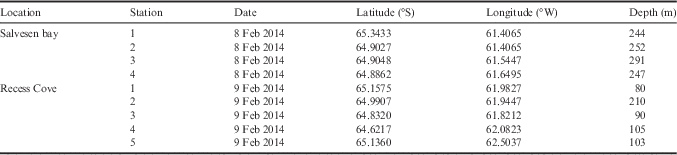
Table II Geographical locations of the oceanographic stations, February 2014
Sampling was divided in two phases to compare the summer conditions in two different years. The first phase was on 4–6 February 2013 and the second was on 8–9 February 2014. The Chilean Antarctic Institute (INACH) Scientific Expeditions Nos 49 and 50, on board the Chilean Navy vessel AP Aquiles, installed a total of 18 and 10 oceanographic stations, respectively. Aboard a Zodiac boat, we approached as close as possible to the front of the main glacier and made oceanographic measurements along a transect perpendicular to the glacier head, each transect consisting of approximately five stations ~1 n mile apart. Exploratory bathymetry was obtained with a portable 50 kHz echo sounder. Vertical profiles of temperature, salinity, oxygen, fluorometry and pH were collected with an SBE 19 Plus V2 CTD-T system up to 100 m deep. Turbidity measurements were recorded with an ECO NTU (0–1000 NTU). Data were processed using SEASOFT 4.22.
The effect of wind on the sediment plumes was not considered in our study, since during the measurement period there was only very light to no wind in the bays.
During the First Antarctic Expedition of Colombia on board ARC 20 de Julio in January–February 2015, water samples were collected from Gerlache Strait and small bays on the Danco Coast using a Rosette sampler with Niskin bottles. These samples, together with the CTD-T turbidity measurements, were used to determine the concentration of total suspended solids (TSS) using a standard laboratory procedure according to APHA-AWWA-WEF (2012). Using the TSS concentrations and the nephelometric turbidity units (NTU) obtained with the CTD-T, a conversion relationship from NTU to mg l-1 was obtained through a linear regression analysis (Fig. 2).

Fig. 2 Linear regression analysis graph and conversion relationship between nephelometric turbidity units (NTU) and total suspended solids (TSS) in mg l-1.
To determine the tide during the measurements we used the Tide Model Driver (TMD) Matlab package (Padman Reference Padman2005), with the Antarctic Peninsula High-Res Tide Model AntPen04.01 (http://www.esr.org/ptm_index.html). The tide results were compared with data from tide gauges at Prat Station (62.48°S, 59.63°W) and Gabriel Gonzalez Videla Station (64.76°S, 62.85°W) with satisfactory results.
Results
Hydrographic profiles
According to similarities in the patterns of the vertical distribution of temperature and salinity, and geographical location, the bays were classified as external or internal. The external bays, Curtiss Bay and Paradise Harbour/Oscar Cove, were located at the extreme north and south of the Danco Coast. These bays had a colder and more saline surface water tendency relative to the internal bays. The characteristics of the internal bays, Recess, Beaupre and Salvesen, were better associated with the hydrography of the central–northern part of the Gerlache Strait.
For the internal bays Recess and Beaupre during the 2013 summer, the vertical profiles of temperature and salinity showed a similar pattern (Fig. 3). From the surface to ~40 m depth, the temperature was positive, reaching a maximum of 2°C at the sub-surface. Below ~40 m depth, the temperature was usually more uniform, near 0°C. For the first few metres below the surface the salinity was relatively low reaching <32, increasing to nearly 34 at 20–30 m. A thin layer of fresher, colder water was present at the surface. The turbidity in these areas also showed a similar pattern. A near-surface maximum centred at ~8 and ~20 m for Recess and Beaupre, respectively, and a deeper maximum centred at ~80 m depth. However, the magnitudes of turbidity were different between the bays. The turbidity was >1.0 NTU (6.45 mg l-1) at the sub-surface at the station closest to the coast in Beaupre Cove, and the values for the lower layer were about twice as high as the values in the same location in Recess Bay. For both areas, salinity variability was not significant anywhere along the transects. In contrast, temperature varied between stations, especially for depths >20 m. Measurements were taken during a flood tide in Recess and an ebb tide in Beaupre.

Fig. 3 Hydrographic variables (temperature and salinity) and turbidity profiles for Frei (Recess Cove) and Beaupre bays (internal bays) measured during the 2013 campaign. The locations of the oceanographic stations are indicated in the corresponding maps by red circles. The height of the forecast tide for each bay is also shown.
In 2014, Recess and Salvesen bays showed similar patterns of temperature and salinity (Fig. 4), with a maximum temperature at the sub-surface (~2°C at 10 m depth). In both bays, a thin tongue of fresher, colder surface water was present and there was a constant decrease in temperature below 20–40 m deep (thermocline). Variability was observed between the stations for each bay, with colder temperatures at the deepest levels for the stations located closer to the coast. Salinity at the surface was 32.5, increasing to ~34.4 below 80 m. Both bays displayed the same pattern of salinity and there was little variability between stations. For Recess, the oceanographic measurements were taken during a flood tide in 2013 and an ebb-low tide in 2014 (Figs 3 & 4). The measurements taken in Salvesen bay in 2014 were at the end of a slack tide and the beginning of a second flood tide. Differences in turbidity were noted in Recess, with higher turbidity recorded in 2014 compared to 2013 (Figs 3 & 4).

Fig. 4 Hydrographic variables (temperature and salinity) and turbidity profiles for Frei (Recess Cove) and Salvesen bays (internal bays) measured during the 2014 campaign. The locations of the oceanographic stations are indicated in the corresponding maps by red circles. The height of the forecast tide for each bay is also shown.
In 2013, the external bays, Curtiss Bay and Paradise Harbour/Oscar Cove (Fig. 5), generally showed different temperature and salinity distribution patterns compared to the internal bays (Figs 3 & 4). Curtiss Bay had a nearly constant temperature of 0–0.5°C at depths below ~20 m. Similar trends but warmer temperatures (>0°C) were measured in Paradise Harbour/Oscar Cove. A colder, fresher surface layer was observed in Curtiss Bay. In Paradise Harbour/Oscar Cove, stations 3 and 4 showed slightly colder waters than stations 1 and 2, possibly indicating the influence of waters from the glacier located further north. The differences in temperature and salinity between stations were more evident in the upper layer (0–40 m depth) in Curtiss Bay. The same is generally true for Paradise Harbour/Oscar Cove, except that the values for the first station close to the glacier are different in the entire water column with respect to the outer stations, especially for the lower layer (40–100 m depth). In general, weakly stratified portions of each hydrographic profile are co-located with lower turbidity values. The tide period for both areas was similar (flood tide) (Fig. 5).

Fig. 5 Hydrographic variables (temperature and salinity) and turbidity profiles for Guesalaga (Curtiss Bay) and Paraíso (Paradise Harbour/Oscar Cove) bays (external bays) measured during the 2013 campaign. The locations of the oceanographic stations are indicated in the corresponding maps by red circles. The height of the forecast tide for each bay is also shown.
Oceanographic profiles
Oceanographic profiles for each bay (Figs 6 & 7) show that most stations had a colder, fresher surface tongue of water coming from the tidewater glacier and warmer sub-surface waters. However, this was not clear in Paradise Harbour/Oscar Cove and Recess (2013). From 40–100 m, there was another cold layer with a longitudinal extension of ~2–4 km from the station closest to the glacier. The salinity increased with depth and there was a tendency to be fresher closer to the glacier and at the surface. Density had a similar pattern to salinity. There were no strong horizontal density gradients observed, except in a few tips of the freshwater tongues at the sea surface. Higher turbidity concentrations were generally associated with the colder, fresher waters in surface layers and the cold water tongues in deeper layers. For example, these trends are clearly visible for Curtiss Bay at the surface (Fig. 6) and for Recess Cove in deeper layers (Figs 6 & 7).

Fig. 6 Hydrographic variables and turbidity profiles for Curtiss Bay (Guesalaga), Recess Cove (Frei), Beaupre Cove and Paradise Harbour/Oscar Cove (Paraíso) during the 2013 campaign. Turbidity scale for Beaupre Cove is different (0–1 NTU).

Fig. 7 Hydrographic variables and turbidity profiles for Salvesen bay and Recess Cove (Frei) measured during the 2014 campaign.
Discussion
Glacier sources of turbidity
The data support the presence of sediment plumes extending from the glaciers in all of the bays we studied along the Danco Coast. These plumes are identified by the higher turbidity concentrations and the associated cold water tongues. The hydrographic structure of temperature, salinity and particle concentration is very similar to that found in larger fjord systems on the Danco Coast (e.g. Domack & Williams Reference Domack and Williams1990, Domack & Ishman Reference Domack and Ishman1993, Domack et al. Reference Domack, Foss, Syvitski and McClennen1994, Powell & Domack Reference Powell and Domack1995). This suggests that similar mechanisms are operating independent of the size of the glacier and the glacier’s drainage basin. Therefore, the sediment from small bays could play an important role in regional sedimentary processes. Greater complexity of the sediment plumes in the larger bays may be a consequence of receiving sediment from several glaciers. In our study, there was generally a single main glacier and the shape of each bay was simple. However, for study areas such as Paradise Harbour/Oscar Cove and Salvesen bay, where sediment could be provided by several nearby glaciers, the observed plumes were a little more diffuse or not very well formed as a tongue.
From our fieldwork, we observed that the waters of the Danco Coast were very clear or transparent, indicating low sediment input to the bays. Turbid flow at the surface was not evident with the naked eye, consistent with the low surface turbidity values measured by the CTD-T (<~3.38 mgl-1 suspended particle concentration on average). This contrasts with the bays of the South Shetland Islands, as observed by Griffith & Anderson (Reference Griffith and Anderson1989), denoting the differences between the two climatic regions, and climate control on glacial melting and sediment flow processes in glacimarine environments. Recent results by Yoo et al. (Reference Yoo, Lee, Il Yoon, Il Lee and Kang2015), who used data from Marian Cove on King George Island (South Shetland Islands), show that in general the concentrations of suspended particles in the water column in the surface ice-proximal zone are higher than in the same zone in small bays on the Danco Coast (~5.36 vs ~3.38 mg l-1 on average, respectively).
In general, the results showed the formation of two main sediment plumes: a thin plume near the sea surface that is characterized by its low salinity and temperature, and another deeper plume characterized by its constant horizontal low temperature. Other small plumes can be also present close to the glacier. The deeper plume maintains its shape and horizontal extension ~4 km from the glacier, with gradually decreasing particle concentration (Fig. 8). Further from the source, larger particles cannot be transported (McClimans Reference McClimans1978, Trusel et al. Reference Trusel, Powell, Cumpston and Brigham-Grette2010), and mixture processes and forces associated with the current dynamics weaken or alter the plumes (Yoo et al. Reference Yoo, Lee, Il Yoon, Il Lee and Kang2015), thus the plume extension is limited. Similar values for plume extension were reported by Zajączkowski (Reference Zajączkowski2008) for fjords in Svalbard in the Arctic. They found that meltwater at the glacier front formed a current that flowed at 0.8 m3 s-1 and transported material up to 6.5 km seaward. During this transport, the particle concentration decreased at the surface while at the same time increased at deeper levels. This conclusion agrees with the Domack & Ishman (Reference Domack and Ishman1993) Danco Coast model and supports the fact that coarse terrigenous sediments will be deposited in the vicinity of the glacier, given the short horizontal range of the plume.

Fig. 8 Simple and general model of glacier sediment plumes for the studied small bays. Two main plumes are identified: a thinner upper and a thicker lower. The flux of the plumes is indicated by black arrows, and the flux of warmer landward water by a white arrow. The particle concentration decreases gradually seaward. The plume extension also depends on the tide period; an ebb tide favours plume extension. No oceanographic data are available below 100 m or very close to the glacier (including bathymetry).
The plume formation and vertical position could be associated with a buoyant equilibrium as is indicated by some models (e.g. MacAyeal Reference MacAyeal1985, Mugford & Dowdeswell Reference Mugford and Dowdeswell2011). In general, there is concurrence in the spatial extension and distribution of the plumes with the thermal structure and density. The temperature profiles show a stratification of two main layers and a thermocline. First, a thin layer from the surface to 10 m depth, below this is the thermocline, and then a lower layer from 40–100 m. Within these two layers are the sediment plumes. The deeper layer is below the 1027.5 kg m-3 isopycnal. A slight tilt of the isopycnal in the area of the plumes closer to the glacier (Figs 6 & 7) indicates a trend of these plumes to rise. This suggests that the main source of sediment is a plume emerging from beneath the tidewater glacier at the head of each bay.
Role of tides in particulate transport
During this study, the influence of the tide on the sediment plumes was also taken into account. By analysing the daily variability of the tide, we observed that the bays with higher turbidity and longitudinal extension coincided with the ebb tide. If we compare Recess Cove in 2013 when measurements were performed during a flood tide with the period in 2014 when measurements were taken during the ebb tide, the concentration and seaward extension of the sediment plume below 40 m were intensified during an ebb tide. All of the data from the other bays corroborate that measurements taken during a flood tide were less intense, even with similar hydrographic characteristics. The same behaviour was noticed by Yoo et al. (Reference Yoo, Lee, Il Yoon, Il Lee and Kang2015) in Marian Cove, who argued that flood tide with a wind toward the head of the cove may result in settling of the particles in the ice-proximal zone.
According to several authors (e.g. Lake & Walker Reference Lake and Walker1976, Powell & Domack Reference Powell and Domack1995, Pichlmaier et al. Reference Pichlmaier, Aquino, DaSilva and Braun2004) the surface sediment flux, associated with a colder, fresher water tongue in fjord systems, is due mainly to glacial melting as well as other factors. Our measurements were performed in mid-summer without sea ice formation and with low winds, under conditions of low radiation (cloudy) and without precipitation during the entire expedition. Therefore, we assume that glacier melting was the primary factor in the formation of the observed plumes.
Water mass sources and its influences in the bays
Below the cold surface layer, there is a denser, warmer layer with higher salinity, which may have formed as a product of a compensatory landward flux. It is possible that this water comes from the Gerlache Strait and it is modified by mixing as it moves into the fjords. From the data it is unclear if this contributes to the melting of the glacier front but in Curtiss Bay where colder waters reside on the shelf, no lower plume was detected and the surface plume was very small. Since no data collected was below 100 m (Fig. 8) it is not possible to know if there is a contribution of warmer water to the base of the glacier. Furthermore, we cannot consider the input of the Circumpolar Deep Water, which would enter the strait by deeper passages (García et al. Reference García, Castro, Ríos, Doval, Rosón, Gomis and López2002, Zhou et al. Reference Zhou, Niiler and Hu2002). Below 50 m the water characteristics, in temperature and salinity, resemble those of the Transitional Zonal Waters that are influenced by the Bellingshausen Sea (TBW) and the deeper underlying layer resembles the Transitional Zonal Waters that are influenced by the Weddell Sea (TWW) (Niiler et al. Reference Niiler, Amos and Hu1991, García et al. Reference García, Castro, Ríos, Doval, Rosón, Gomis and López2002, Sangrà et al. Reference Sangrà, Gordo, Hernández-Arencibia, Marrero-Díaz, Rodríguez-Santana, Stegner, Martínez-Marrero, Pelegrí and Pichon2011). The colder characteristics of Curtiss Bay were probably due to intrusions of waters coming from the southern region of the Bransfield Strait or TWW, while for the internal bays there is more influence from warmer waters of the Bellingshausen Sea. Paradise Harbour/Oscar Cove, located in the southern extreme, showed characteristics more associated with Lower Circumpolar Deep Water (LCDW) (García et al. Reference García, Castro, Ríos, Doval, Rosón, Gomis and López2002). It is likely that there is some association between the warmer waters coming from the continental shelf and the creation of the sediment plumes from the glacier, as reported for Greenland (Sciascia et al. Reference Sciascia, Straneo, Cenedese and Heimbach2013). The surface waters of the Gerlache Strait generally show a gradient from north to south: warmer and saline to the north and colder and less saline to the south (Martínez et al. Reference Martínez, Sangrà, Lubián, Antorranz, Pelegrí, Rodríguez and Sobrino2002). However, our results show an inverse of this gradient in coastal waters during the 2013 summer. We speculate that this might be possible if there are alternating cycles of cold and warm periods associated with external climatic fluctuations at different scales, added to the variability of the local influence of water masses on water properties in bays.
Conclusions
Five small bays on the Danco Coast were studied using a CTD-T that profiled from the surface to up to 100 m depth. Curtiss Bay, Recess Cove, Beaupre Cove, and Paradise Harbour/Oscar Cove were sampled in February 2013, and Salvesen bay and Recess Cove were sampled in February 2014. In general, the results demonstrate the existence of sediment plumes at two levels: an upper plume from the surface to 10 m, and another plume located deeper, below the thermocline, from 40–100 m. These plumes were identified by their higher turbidity concentrations and the associated colder water tongues. The origin of these sediment plumes is probably related to the main glacier meltwater which flows into the bay. Low concentrations of suspended particles (maximum~6.45 mgl-1) were found for the plumes. The surface plume was colder and fresher compared with the sub-surface layer, and the deeper plume was also colder but with normal values of salinity. The latter layer tended to remain below the 1027.5 kgm-3 isopycnal and had a horizontal extension ~4 km from the glacier, maintaining its shape and gradually decreasing its particle concentration. This longitudinal extension is favoured by ebb tides.
The northern Curtiss Bay is colder than the other bays, this may be due to the influence of the Bransfield Strait waters and/or the TWW. The internal bays (Recess, Beaupre and Salvesen) are warmer due to the influence of the Bellingshausen Sea. The southernmost bay (Paradise Harbour/Oscar Cove) showed characteristics associated with inflow of LCDW. The input of water masses to the bays and their heat content could influence the creation of the sediment plumes from the glacier.
Despite being small bays with relatively small glaciers flowing into the bay, the temperature, salinity and turbidity patterns were similar to larger fjords on the Danco Coast. Therefore, the contribution of sediments from these small bay systems could play an important role in regional sedimentary processes, especially given the vulnerability of glaciers to climate change. To establish whether these plumes are ephemeral or not, and to determine the factors that influence their behaviour, it is necessary to perform repeated measurements of the oceanographic variables over longer time periods at the same locations, as was done for Recess Cove, where comparisons of measurements taken in two different years (2013–14) enabled us to demonstrate the influence of the tide.
Acknowledgements
This study was funded by Fondecyt No. 11121522 grant to C.R. and the INACH. GMT (http://gmt.soest.hawaii.edu/) and Ocean Data View (http://odv.awi.de/) software were used for some figures. The authors thank the logistic support of INACH and the Chilean Navy, especially the crew of the AP Aquiles (2013–14), including the Infantes de Marina personnel. Special thanks to the Captain Jaime McIntyre. Also we thank the support of the Colombian Navy, officers, crew and scientific party on board the ARC 20 de Julio. Special thanks to Diana Quintana (CIOH) for the TSS analysis, and Emilio Mena and Stephanie Latour for their help with the manuscript. We would also like to thank the Editor, Laurie Padman, for his constructive comments and the anonymous reviewers.
Author contributions
C.R. developed the project, established the main ideas, objectives, field work design and wrote the paper. All authors contributed to data processing and interpretation.


