

Our microecological model answers, then, to the direction that some urban economic historiography has hesitantly taken. It encourages us to conceive towns less as separate and clearly definable entities and more as loci of contact or overlap between different ecologies. Towns are settings in which ecological processes may be intense, and in which the anthropogene effect is at its most pronounced. But they are not – or not simply by definition – more than that. And they should not be presented as conceptually detachable from the remainder of the spectrum of settlement types. (Horden and Purcell Reference Lafe, Bejko and Hodges2000, 100–1)
INTRODUCTION
Butrint, ancient Buthrotum, in south-west Albania, is a quintessential small port that prospered significantly in Roman times,Footnote 1 having been a Hellenistic sanctuary, and briefly prospered again as a Mid-Byzantine town from the eleventh to fourteenth centuries. Excavations by the Butrint Foundation between 1994 and 2012 showed, in effect, that it was a small urban community intermittently from the second century bc through until the later Byzantine period (Hodges Reference Hodges2006; Reference Hodges, Hansen, Hodges and Leppard2013). The Butrint Foundation project also endeavoured to establish its relationship with its environs in order to test Horden and Purcell's thesis in their seminal book, The Corrupting Sea (Horden and Purcell Reference Lafe, Bejko and Hodges2000), that the port was not ‘conceptually detachable’ from its hinterland. Like Nicopolis, Octavian's Victory City founded 100 km south of Butrint, the subject of major archaeological field surveys in the 1980s (Wiseman and Zachos Reference Wiseman and Zachos2003; Tartaron Reference Tartaron2004), the coastal port of Butrint occupies a lagoon landscape, adjacent to the Straits of Corfu, but with connections into the mountainous interior (cf. Metallinou Reference Metallinou2008, 112).
The Butrint Foundation project involved several different investigations to examine the relationship of the town through time with its immediate hinterland. These included excavations of the Early Roman Bridge connecting the isthmus (by way of the Vivari Channel) to the Vrina Plain and the inland valley extending to Konispol (Leppard Reference Leppard, Hansen, Hodges and Leppard2013). It also included excavations of the suburb on the Vrina Plain, created in the Early Roman period, connected by the bridge to the main town. In the Vrina Plain excavations, a section of the road linking the bridgehead beside the Vivari Channel to the inland valley was excavated (Greenslade and Leppard Reference Greenslade, Leppard and Greensladeforthcoming). Beyond this suburb, the project undertook surveys of the surrounding area. This took five forms. The first involved a study of the aerial photography dating from the Second World War showing two phases of centuriation dating to the Early Roman period (Bescoby Reference Bescoby2006; forthcoming) (Figs. 1, 2). The second involved two field surveys, a survey of the cemetery along the Vivari Channel (Hernandez and Mitchell Reference Hernandez, Mitchell, Hansen, Hodges and Leppard2013), and associated environmental surveys. The environmental surveys revealed the changing ecological circumstances of this lagoon landscape (Lane et al. Reference Lane, Bescoby, Gilkes, O'Hara, Hodges, Bowden and Lako2004; Bescoby Reference Bescoby2006; Bescoby, Barclay and Andrews Reference Bescoby, Barclay and Andrews2008; Bescoby Reference Bescoby, Hansen, Hodges and Leppard2013). The first field survey undertaken in 1995–6 focused upon the area immediately around Butrint (Pluciennik et al. Reference Pluciennik, Lako, Përzhita, Brennan, Hodges, Bowden and Lako2004) (Fig. 1). The second survey, undertaken in November 2008, examined an area further to the east, including the villages of Mursi and Xarra. This second survey comprised a corridor of land reaching from the south shore of Lake Butrint at the site of the Roman villa of Diaporit to a point 2 km east of the modern village of Mursi (Fig. 3). Undertaken by Alessandro Sebastiani and Emanuele Vaccaro, this limited second field survey offered an opportunity to further examine the thesis that Butrint, as a typical Mediterranean port, was always inextricably attached to its hinterland. This report describes the results of the ‘Mursi survey’, and, in the light of the interdisciplinary evidence from the other excavations in Butrint and the previous surveys, argues that for much of its history, Butrint had a limited engagement (in terms of cultivating gardens and herding) with its hinterland.


Fig. 2. Aerial photographs taken by the Royal Air Force in 1943 showing alignments of Roman fields between Butrint and Xarra. The white lines relate to grid 1; the black lines to grid 2; and the dotted black line indicates the course of the Xarra–Butrint aqueduct (Courtesy of D.J. Bescoby; Crown Copyright 1943/MOD).

Fig. 3. Map showing the location of the ‘Mursi survey’, and the monuments found.
I. PREVIOUS SURVEYS OF THE BUTRINT HINTERLAND
The landscape of the Butrint region is dominated by a rugged inland mountain range and a smaller, denuded coastal range of steeply inclined beds of limestones, dolomite and sandstone, and slumped flysch deposits, dissected by numerous small streams. The two ranges are separated by a large valley leading up to Konispol, up to 2 km wide and infilled by a succession of Quaternary and Holocene deposits. Lake Butrint, occupying the valley centre, is fed by a river from the north and its waters exit into the Straits of Corfu through a gap in the coastal range, flowing westwards around the limestone spur that projects inland from the Ksamil Peninsula upon which Butrint is located.
The modern alluvial plain (the Vrina Plain) extends away from Butrint to the south-east and contains the occasional outcrop of limestone, such as the fortified hilltop site of Kalivo, bordering the southern margin of Lake Butrint, and the hill on which sits the monastery of Shën Dëlli. The widespread and dynamic nature of the fluvial regime within the valley during the Pleistocene is evident from the large relic gravel terraces that form a ridge along the south-eastern edge of the valley. These largely denuded deposits stretch from Mursi towards the limestone outcrop of Kalivo. Similar fluvial deposits abut the southern flanks of the limestone outcrops upon which the modern day settlements of Shën Dëlli and Vrina are located, and it is likely that these relic outcrops form a sediment trap, their presence diverting the flow of downcutting channels. Several exposures to the north of Xarra show inclined graded bedforms, indicating a degree of tectonic uplift. It is likely that these alluvial units are broadly comparable to the Younger Fill of Vita-Finzi's Mediterranean alluvial sequence (Vita-Finzi Reference Vita-Finzi1969), although these may represent a number of discrete, temporally separate units. The soils found today upon the floodplain are rendzina-like alluvial soils, or entisols/fluvients under the American soil classification system (Lane et al. Reference Lane, Bescoby, Gilkes, O'Hara, Hodges, Bowden and Lako2004).
The recent environmental context for Butrint is fairly typical of the Mediterranean, being dominated by at least three millennia of episodic alluvial sedimentation. The result has been the formation of a distinctive coastal plain known as the Vrina Plain, and the progradation of the coastline westwards by over 2 km. About eight millennia ago, an extensive estuary extended inland along the fault-bound valleys to the north and south of Butrint. As sea-level rise slowed, accumulating sediments brought in from the mountainous Epirote catchment rising to Mount Mile and beyond began to infill the valleys, the extremities of the estuary slowly becoming cut off from the influence of the Straits of Corfu. This process probably accelerated from the Middle Bronze Age, as large areas of the territory underwent extensive vegetation clearance. Lake Butrint itself is testimony to this once extensive coastal embayment, while the coastal floodplain today bears witness to agricultural intensification during the later communist period from c.1960–90, crisscrossed with a network of irrigation and drainage channels. The once-reclaimed seaward margins of the coastal plain have now begun to revert to a wetland environment (Bescoby, Barclay and Andrews Reference Bescoby, Barclay and Andrews2008).
The degree to which this dominant regime of large-scale sedimentary deposition and floodplain growth impedes archaeological visibility has been amply demonstrated by the results of past geophysical survey of the alluvial plain adjacent to Butrint, leading to the discovery and subsequent excavation of the extensive Vrina Plain settlement. Palaeo-environmental studies at Butrint have since focused on reconstructing snapshots of this changing landscape at key moments in the town's history and on assessing the consequences of living within an often fast-changing and unpredictable environment. One of the great challenges has been sufficiently resolving temporal connections between the town and its immediate environment, since disparity in chronological resolutions prevents anything more than broad correlations being made. The establishment of a high-resolution chronology for the sedimentary sequence of the Vrina Plain has allowed cultural and environmental sequences to be tied closely together, enabling the making of a detailed landscape reconstruction, especially for the Roman period (Bescoby Reference Bescoby, Hansen, Hodges and Leppard2013).
The 1995–6 field survey of the area south and east of Butrint (Fig.1) was the first intensive survey of its kind to be carried out in Albania (Pluciennik et al. Reference Pluciennik, Lako, Përzhita, Brennan, Hodges, Bowden and Lako2004; Lafe Reference Lafe, Bejko and Hodges2006, 333). In many respects it covered the same territory in the eastern hinterland of the town that had been surveyed in terms of monuments (following drainage work) by Dhimosten Budina in the 1960s (Budina Reference Budina1971). In essence, three different areas were systematically prospected: the Vrina Plain, immediately beside the Vivari Channel, where subsequently a Roman suburb of Butrint was located; the hills to the north of the Vrina Plain bordering the southern shore of Lake Butrint and including the fortified prehistoric hilltop of Kalivo; and the promontory to the south of Butrint known as Cape Stillo or the Korafi Hills. The methodology involved teams walking across the landscape at 10 m intervals where visibility was poor, and 5 m where it was good. This limited survey provided a picture of the context of the port of Butrint.
The 1995–6 Butrint survey recognised its limitations. The absence of small scatters – background scatters – was observed. There was also a lack of obvious evidence for pre-Roman and post-Roman sites. The restricted chronology of the survey evidence suggested that there may have been Roman management of the Butrint hinterland which obscured evidence of any pre-Roman settlement. Added to this, it was recognised that the changing environmental circumstances undoubtedly determined to some degree any understanding of the pattern of settlement after the Roman period (Pluciennik et al. Reference Pluciennik, Lako, Përzhita, Brennan, Hodges, Bowden and Lako2004, 57).
Further, limited research (currently unpublished) to the west of Butrint, around Alinura Bay has added to this picture of significant Roman intervention in the landscape, but minimal pre- or post-Roman occupation (José Carvajal, pers. comm.). Most of all, the 1995–6 survey gave rise to a detailed analysis of the environmental context of Butrint and the changing form of Lake Butrint over time. In particular, the Vrina Plain altered in form considerably after seismic events in the fourth century, with the precursor of the early modern marshes taking shape in the Mid- to Late Byzantine periods (Bescoby Reference Bescoby, Hansen and Hodges2007; Bescoby, Barclay and Andrews Reference Bescoby, Barclay and Andrews2008; Bescoby Reference Bescoby, Hansen, Hodges and Leppard2013). The final phase of the Vrina Plain community coincides with the revival of Butrint as an urban community (Hodges Reference Hodges2015, 212). It appears that the water table was steadily rising, making occupation of the plain difficult after c.1200. Colluvium, perhaps created by increased pastoral activity and woodland clearance on the hills and around the plain, may be one reason for these changing environmental conditions. Similar circumstances were also found to have been occurring around the lagoon at Glyki some 100 km south of Butrint (Tartaron Reference Tartaron2004; Wiseman and Zachos Reference Wiseman and Zachos2003).
As a result of the 1995–6 field survey a more developed analysis of the possible Roman centuriation was made in the region to the east of Butrint (Figs. 1, 2). This has been described in some detail elsewhere (Bescoby Reference Bescoby, Hansen and Hodges2007; Reference Bescoby, Hansen, Hodges and Leppard2013; forthcoming). In summary, using photographs taken at about 10,000 feet by the Royal Air Force during 1943, Bescoby detected traces of two phases of Roman-period centuriation in the area between Butrint and the valley to the east of Mursi. He summarised these as:
-
• Augustan-period or earlier influence detected in the form of land divisions within the valley conforming to 20 × 20 actus units aligned with a pre-existing approach road.
-
• Augustan-period aqueduct and new approach road running alongside and aligning with the crossing point over the Vivari Channel into Butrint. The alignment deviates from the proposed centuriation grid. The development of the Vrina Plain suburb of Butrint from the mid-first century focused along this new road axis and the Vivari Channel crossing point. It is likely that the road bridge into Butrint (Leppard Reference Leppard, Hansen, Hodges and Leppard2013) dates to this era.
-
• From the mid-third century a substantial villa occupies much of the original Vrina Plain settlement close to the bridgehead and the approach road appears to have been diverted past a large mausoleum to the north-east. It is possible that the centuriation arrangement was no longer fully functioning.
It was clear by 2008, in summary, that there is excellent evidence of major Early Roman intervention in the landscape around Butrint associated with the creation and early evolution of the Augustan colony. Before and after this pronounced Early Roman intervention, exploitation of this landscape appears to have been less systematic.
II. THE ‘MURSI SURVEY’ (FIG. 3)
The ‘Mursi survey’ followed on from the previous surveys, and was undertaken in November 2008 by two of the authors (AS and EV) with the collaboration of Dhimitër Çondi from the Institute of Archaeology in Tirana. The ground conditions were good as the vegetation cover was limited. The survey covered an irregular corridor of territory between the excavated Hellenistic and Roman villa at Diaporit (Bowden and Përzhita Reference Pluciennik, Lako, Përzhita, Brennan, Hodges, Bowden and Lako2004; Reference Bowden and Përzhita2014) and the Hellenistic and Roman villa at Malathrea to the south-east of the modern village of Mursi (Çondi Reference Çondi1984; Giorgi and Bogdani Reference Giorgi and Bogdani2012, 253–4). This corridor of land amounted to about 4 km2. The corridor comprised fields along the lowest west-facing slopes of Monte Mile. Specifically, the small-scale survey investigated the area around Lake Bufi, the zone on either side of the Roman aqueduct to the west of the modern village of Xarra, and the pronounced ridge running from the village of Xarra through to and past the modern village of Mursi, up to the site of the villa at Malathrea (Fig. 4). Apart from allotments and gardens in the two villages within the survey area, this survey included open fields to the west of Xarra, as well as small pastures and orchards in the Pavllas valley leading from Mursi eastwards past the villa at Malathrea to the outlying hill on which the site of Çuka I Aitoit is located, and ultimately to Konispol at the end of this closed valley. This limited survey also aimed to establish if there was a major Roman site at Mursi, associated with the Early Roman family, the Pomponii (cf. Hansen Reference Hansen2009, 17–29).

Fig. 4. View of Mursi, its school in the foreground, the artificial lake and the valley leading to Çuka i Aitoit (Courtesy of David Hernandez).
III. METHODOLOGY
The survey in the area of the corridor from Diaporit-Mursi was undertaken using a traditional methodology (see, for example, Cherry, Davis and Mantzourani Reference Cherry, Davis and Mantzourani1991; Lafe Reference Lafe, Bejko and Hodges2006 for a review of these methods in Albania). As a first step all available cartographic sources were collected together and uploaded into a Trimble XT hand-held GPS in order to input points or buffer zones when a new site or a scatter was found. Principally, the area was surveyed by walking the fields in parallel rows at intervals of about 10 m, collecting all the available evidence (pottery, tiles, lithic objects etc.) without focusing on a particular period. A starting point was provided by known sites (i.e. the Roman villas at Diaporit [Bowden and Përzhita Reference Pluciennik, Lako, Përzhita, Brennan, Hodges, Bowden and Lako2004; Reference Përzhita, Gjipali, Hoxha and Muka2014] and Malathrea [Çondi Reference Çondi1984; Giorgi and Bogdani Reference Giorgi and Bogdani2012: 253–4] and the ruined, Byzantine church at Çiflik), and then the fieldwork was expanded into the surrounding areas.
Much of the landscape was open but small sections of it around the villages of Mursi and Xarra were covered by citrus plantations. As the survey was undertaken in the late autumn, the absence of ploughed fields together with thick alluvial deposits has probably obscured some sites and skewed the results.
In spite of these problems, 83 scatters/sites (of which 25 were ‘monuments’) were found and these are listed in Table A1 in the Appendix. Some of these sites, such as the pillars of the Roman aqueduct from Xarra to Butrint running across the Vrina Plain (Wilson Reference Wilson, Hansen, Hodges and Leppard2013) and the major villas at Diaporit and Malathrea, were already well known. Every scatter was recorded by the hand-held GPS and then converted into a perimeter in the GIS platform. For major sites it was decided to put just a point to indicate the spot, while surviving walls are indicated as lines. Every diagnostic fragment was drawn and later retouched into Adobe Illustrator to create plates and illustrations. More than 40 fabrics were recorded and analysed. Discussion of these is partly based on the preliminary study carried out by Paul Reynolds (Reference Reynolds, Hodges, Bowden and Lako2004), while some new data were established by checking certain sampled fabrics using a Stemi 2000-C Zeiss optical microscope with a magnification range from 6.5 × to 50×.
In order to have a better understanding of the Roman settlement trends and patterns over the Vrina Plain and the territory around Butrint, it was decided to put together the old data of the 1995–6 survey with the new information from the ‘Mursi survey’. All the sites found in the 1995–6 survey have been entered and geo-referenced in the GIS platform.
IV. SURVEY RESULTS
The survey located many scatters/sites with identifiable chronologies. Table A1 in the Appendix sets out the characteristics of the sites found, including the nature of the site, its visibility (with 1 being low, and 3 being high), the proposed dates of the features and the size.
The distribution of the sites and monuments (Figs. 5, 6, 7, 8, 9, 10, 11) found in terms of their material shows the marked impact of the Roman colonisation, almost certainly coinciding with the centuriation. In all 31 sites were identified as of Early to Mid-Roman date (of which 22 were aqueduct pillars and remains), 16 were recognised to be generic Roman (that is, with undiagnostic ceramics in terms of their date), and 12 scatters were specifically characterised by Late Roman ceramics. Some 59 sites belonged to the Roman period. By contrast, a tiny proportion, amounting to nine sites, were prehistoric, Hellenistic or Byzantine in date.

Fig. 5. Pie chart showing the percentages of sites found in the ‘Mursi survey’.

Fig. 6. Pie chart showing the percentages of undiagnostic prehistoric/Hellenistic material (number of sites = 3).

Fig. 7. Pie chart showing the percentages of material from the Hellenistic period (number of sites = 2).

Fig. 8. Pie chart showing the percentages of material from Early Roman sites (number of sites = 31, including Xarra–Butrint aqueduct pillars).

Fig. 9. Pie chart showing the percentages of material from undiagnostic Roman sites (i.e. those scatters without readily identifiable wares) (number of sites = 16).

Fig. 10. Pie chart showing the percentages of material from Late Roman sites (number of sites = 12).
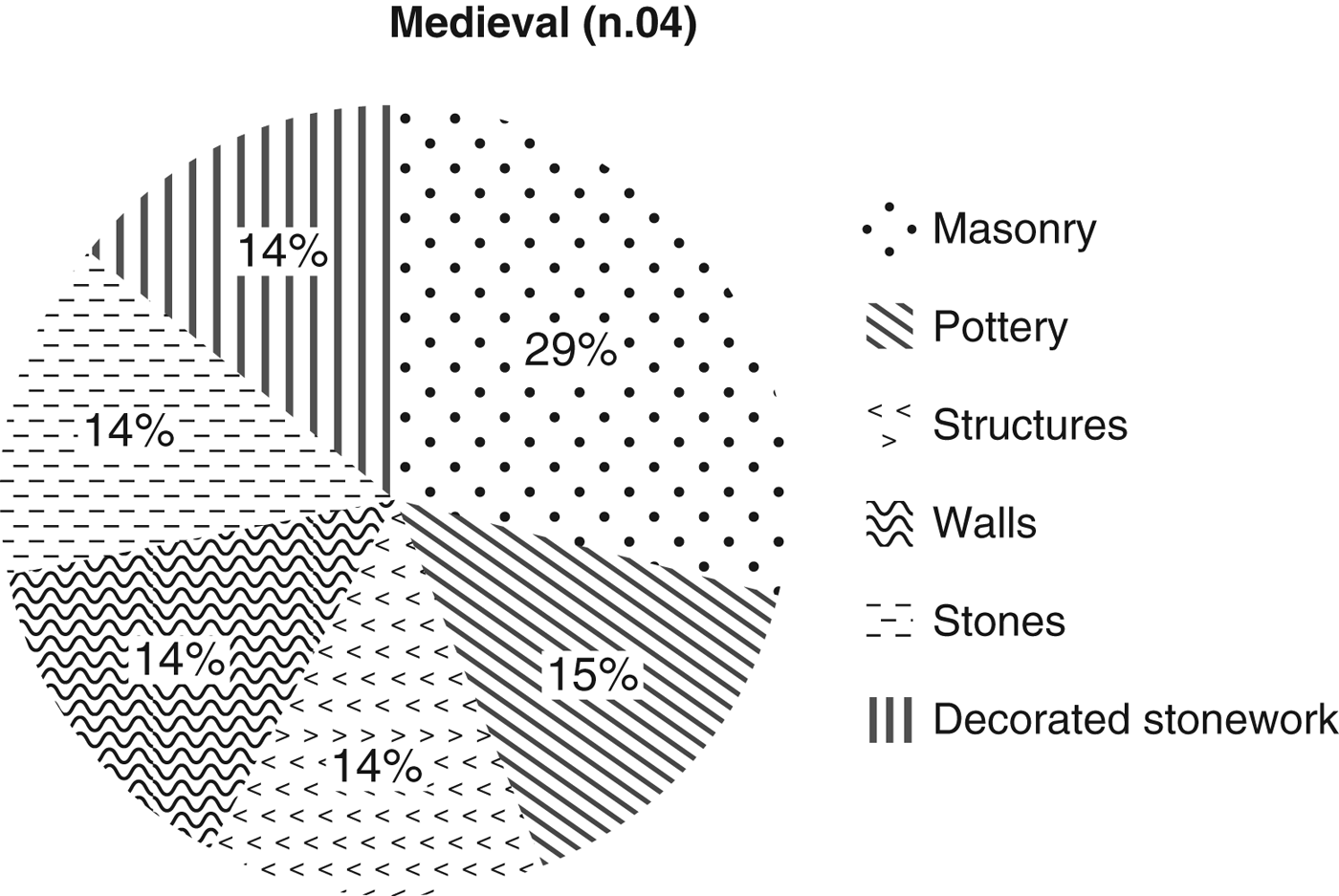
Fig. 11. Pie chart showing the percentages of material from Byzantine sites (number of sites = 4).
A few observations may be made about the more significant of these surface sites, especially those belonging to the Roman period.
A large site (sites 10–16, 27), found on the slope above, and west of, Malathrea, with pottery datable from the second up to the sixth century, represents a settlement that might be interpreted as the pars rustica of the fortified villa or, perhaps an associated open village (Fig. 12). Another possibility is that it represents a late settlement, a successor settlement of the Malathrea villa that lies down the slope near the spring (site 03), the latter having been abandoned during the Early Roman period. Close by, site 04 dates from the Mid- to Late Roman period on the basis of the ceramics. Next to this are little scatters (sites 28–33), possibly dwelling houses or stores, again to be related to the main evidence on the other slope. These dwellings were almost certainly associated with the villa at Malathrea. The presence of a natural water spring close to these sites (site 03) has to be considered as a focal point for any future research of this constellation of Roman-period sites (Fig. 11).

Fig. 12. Location of scatters of mostly Roman-period material close to the Hellenistic and Roman villa of Malathrea.
Remains of another substantial Hellenistic and Early Roman villa were found in the village of Mursi, when the new school was built in the 1960s (sites 64–6 and 83) (Fig. 13). Modern housing on the adjacent hill, as well as the communist-period monument erected at its summit, appears to have destroyed much of the hilltop site through terracing and trenching. A number of diagnostic fragments and the extent of the scatters suggest that the site covered as much as 5 hectares. Reused Roman carved limestone blocks were recorded in modern terrace walls of the school, while local people described the discovery of columns and other architectural elements during the construction of the building (Fig. 13)Footnote 2 . In addition, some Byzantine pottery from sites 67 and 69, shows certain intermittent continuity of use of the settlement into the Byzantine period.

Fig. 13. Location of scatters of Hellenistic, Roman and Byzantine periods at the village of Mursi.
Close to the modern town hall of Mursi lies a hilltop site heavily damaged by the construction of bunkers and an associated military headquarters dating to the communist era. Here a collection of Early to Mid-Roman pottery was recorded (site 04), but no remains of structures were visible.
Around the modern village of Xarra, a few scatters were documented following Budina's survey (1971) but modern construction has altered the visibility of these sites (sites 72–4). Generic Roman pottery and tiles were recovered but these were insufficient to define any buildings.
Another Roman villa or important site has been discovered on the Vrina Plain, beside the standing pillars of the Xarra–Butrint aqueduct (sites 50–1). Here, a standing wall with a threshold in situ and some carved limestone blocks belonged to a Roman-period dwelling, while the pottery, mostly dating to the first and third centuries, included examples of Sigillata Italica (Fig. 14).

Fig. 14. Location of monuments and scatters in the area between Shën Dëlli and Xarra.
At the foot of the hill on which the modern village of Xarra is located, four new pillars of the Xarra–Butrint Roman aqueduct were found (cf. Wilson, Reference Wilson, Hansen, Hodges and Leppard2013). These pillars are not in situ as now they are abutting a modern agricultural channel, but some Roman-period scatters seem to indicate that the aqueduct ran alongside the hill of Xarra in order to enter it and reach a natural water spring. The survey was unable to find any pillars proceeding in the direction of Mursi.
A natural water spring was found on the eastern side of the hill on which the village of Xarra sits. It is just a little stream at ground level, but local people informed us of an ancient fountain that had once existed here before the construction of the present building in recent times.
In sum, the survey indicates four major Roman-period settlements in addition to those already known. The four new settlements comprise those at Shën Dëlli, Shën Dimitri, in Mursi, and close to Malathrea. The absence of Hellenistic, Byzantine and Ottoman ceramics tends to suggest the concentrated nature of settlements in those periods, perhaps – we may surmise – located where the present settlements of Shën Dëlli, Shën Dimitri, Mursi and Xarra are located today. Some confirmation of this is provided by the excavations in 2010 at Mursi, where Hellenistic remains as well as Ottoman ceramics and clay pipe fragments were found (David Hernandez, pers. comm.).
On the exposed hilltop of Shën Dëlli a range of Roman pottery was collected from an opportunistic section. Only the modern monastery and some Byzantine walls and buildings are visible, but this material suggests that a first- to third-century settlement was located here, presumably associated with the suburb at the bridgehead on the Vrina Plain.
Shën Dimitri has been surveyed and some of the already known burials have been recorded by hand-held GPS. The presence of Roman pottery, with dolia and coarse wares, perhaps suggests the existence of a small village or dwellings on the hill (site 04).
V. CONCLUSIONS
Butrint now has ample information about the ancient settlement in its hinterland, thanks to the 1995–6 field survey and the ‘Mursi’ survey made in 2008 described here, as well as the research undertaken by Enrico Giorgi and Julian Bogdani (2012) for the Italian Archaeological Mission focused at Phoinike. To this contextual history we might add the revised topographic history of Butrint, defined thanks to the Butrint Foundation excavations and surveys of the ancient town (Hodges Reference Hodges, Hansen, Hodges and Leppard2013).
The topographic history of Butrint, especially the history of its fortifications and its gates, provides some indication of the town's significant relationship with its hinterland in the later Hellenistic and Roman periods. The Later Bronze Age settlement appears to be one of several small homesteads occupying the coastal region (Lima Reference Lima, Hansen, Hodges and Leppard2013; cf. Tartaron Reference Tartaron2004). Analysis of the ceramics suggests a stronger relationship with inland potting traditions than interactions based upon coastal contacts (Lima Reference Lima, Hansen, Hodges and Leppard2013, 42). Butrint was transformed in the Early Hellenistic period and still more so as it developed as a sanctuary following the Roman occupation of Epirus, when it became the central-place of a koinon (cf. Cabanes and Drini Reference Cabanes and Drini2008, 242–8). This adaptation to be a regional central-place is evident from its fortifications and their gates. The Later Hellenistic Tower Gate, close to the Vivari Channel, suggests that this was the primary entry point into the Later Hellenistic and Republican Roman sanctuary town. Approached from the east, across the Vrina Plain, there was no bridge at this time, so the final passage into Butrint was made by boat. The Tower Gate was built at the time that there was colonisation of the valleys east of Butrint by Later Hellenistic farms, such as the example excavated by the Butrint Foundation at Diaporit (Bowden and Përzhita Reference Bowden and Përzhita2004) and the site of Malathrea, east of Mursi (cf. Giorgi and Bogdani Reference Giorgi and Bogdani2012, 107; 108–14).
The construction of the major bridge across the Vivari Channel was possibly part of the civic works, including the forum (Hernandez and Çondi Reference Hernandez and Çondi2014), belonging to Butrint's elevation to the status of a colony in the Augustan era (Leppard Reference Leppard, Hansen, Hodges and Leppard2013). The major investment in a bridge, most likely replacing earlier ferries, not only improved the connection to Butrint's hinterland, including a suburb on the Vrina Plain at the eastern bridgehead, but also effectively blocked any waterborne passage to Phoinike, the large Hellenistic and Republican hilltop town 25 km to the north, by way of Lake Butrint. It is tempting to regard the construction of the long road bridge with its multiple arches, as the instrument that facilitated not only the sustainability of the suburb at the Vrina Plain bridgehead, but also the creation of the centuriated landscape reaching beyond modern Mursi to the foot of the Hellenistic hilltop site of Çuka i Aitoit (cf. Bescoby Reference Bescoby, Hansen and Hodges2007; forthcoming; Giorgi and Bogdani Reference Giorgi and Bogdani2012, 125–9).
Butrint's relationship with the hinterland appears to have altered in Late Antiquity – if not before – when, in the sixth century, the Water Gate was created in the fortifications erected at that time. With the road bridge still in existence, the Water Gate, like the other Vivari Channel gates in the defences, highlights the increasing importance of a waterborne economy. Changes to the surrounding landscape brought about by seismic events in Late Antiquity described by Bescoby (Reference Bescoby, Hansen, Hodges and Leppard2013) may well have altered the economic priorities for Butrint, diminishing the significance of its hinterland in favour of its seaborne connections.
The closure of the road bridge across the Vivari Channel by an eleventh-century wall (Leppard Reference Leppard, Hansen, Hodges and Leppard2013) – and perhaps its abandonment at this or at any time over the previous four centuries – presupposes the growing importance of seaborne trade and the reduction of Butrint's hinterland to gardens within and immediately around the fortified Byzantine town (Hodges Reference Hodges2015). Certainly, the effective reduction of the road running across the Vrina Plain suburb in the middle Byzantine period tends to add weight to the changing nature of Butrint's relationship with its hinterland, and thus its economy (Hodges Reference Hodges2015; Greenslade and Leppard Reference Greenslade, Leppard and Greensladeforthcoming). Much of this has been confirmed by the geomorphological record that shows intensive activity in the Imperial Roman period, followed by increasing episodes of colluvium resulting in the formation of new marshes by the later Byzantine period if not a little before (Bescoby, Barclay and Andrews Reference Bescoby, Barclay and Andrews2008; Bescoby Reference Bescoby, Hansen, Hodges and Leppard2013) on the Vrina Plain. This, then, is the context for the survey data, including the 2008 survey of the area around Mursi.
The 1995–6 survey identified the prominent remains of the Roman period, especially those belonging to the Earlier Imperial period. Later Roman sites were also evident, especially close to the course of the Pavllas River, though fewer in number, while prehistoric and Byzantine era sites were strikingly rare. The ‘Mursi survey’ appears to confirm this picture. Even with good ground visibility, evidence of the prehistoric and Byzantine periods was found on a tiny percentage of the sites. Of course, sites of these periods might well have been concentrated on the low hills where the present villages of Mursi and Xarra are located. Instead, the survey reinforced the existing model of the limited settlement expansion in the Hellenistic period – probably under the Roman occupation (cf. Giorgi and Bogdani Reference Giorgi and Bogdani2012, 115–29), and significant intensification in the Roman period with not only the renewal of Hellenistic sites such as Malathrea (cf. Çondi Reference Çondi1984; Giorgi and Bogdani Reference Giorgi and Bogdani2012, 253), but also the creation of new villas and most likely small farms close to Xarra, in Mursi and close to Malathrea (sites 4 and 26). A note of caution, though, needs to be reaffirmed, as the excavations by David Hernandez and Dhimitër Çondi at Mursi in 2010 found no trace of any Roman site, but instead remains of a significant Bronze Age settlement that survived into the Hellenistic age. This ‘ground-truthing’ demonstrates clearly how complex the archaeological record is, especially in modern settlements, and how difficult it is to interpret settlement systems from field surveys without recourse to remote sensing and, better still, excavations (cf. Sanders Reference Sanders and Christie2004, 186–7).
In sum, the archaeology of Butrint and its hinterland suggests a network of small-scale Bronze Age hilltops with an emphasis on the mixed exploitation of the lagoon. Settlements in the hilltops were superseded in the mid-first millennium bc by an entirely different settlement system, with a network of Hellenistic fortified villas dependent upon the growing sanctuary town of Butrint. With the drop in the water table, the reclaimed marshes around Butrint on the Vrina Plain became increasingly accessible (cf. Bescoby Reference Bescoby and Greensladeforthcoming). This environmental change facilitated a systematic investment in Butrint in the Early Roman period, as the Augustan colony was involved not only in the making of a civic centre and a road bridge connecting it to the region east of the town, but also in the incentives to centuriate this landscape and exploit it systematically. On the evidence of the Butrint surveys including the ‘Mursi survey’, this was highly intrusive and consistent with the comprehensive Roman conquest and control of the area, as Alcock has observed elsewhere in Roman Greece (Alcock Reference Alcock1993, 171), and as has been noted at Corinth (Romano Reference Romano, Williams and Bookidis2003), Patras and other smaller colonies (Rizakis Reference Rizakis, Rizakis and Lepenioti2010). Several large and small farms appear to have been established, mostly lasting into the second century (like those at Diaporit, Malathrea). However, the settlement history at the bridgehead on the Vrina Plain suggests that this colonial centuriation process was probably succeeded by an estate belonging to the sizeable villa (of some affluence judging from the Attic sarcophagi fragments from the temple mausoleum) that entirely occupied this old suburb, operating perhaps with a network of smaller associated farmsteads (Greenslade Reference Greenslade, Hansen, Hodges and Leppard2013). Importantly, the large Vrina Plain villa occupying the earlier suburb dates to the moment when the Roman (and earlier Hellenistic) villa at Diaporit was abandoned (Bowden and Përzhita Reference Pluciennik, Lako, Përzhita, Brennan, Hodges, Bowden and Lako2004; Reference Bowden and Përzhita2014). It remains to be seen if the other villas found in this survey area were also abandoned at this time. If so, did the Vrina Plain villa take control of all the centuriated area, displacing earlier villa families? Only further excavations will help to determine this.
Judging from the survey data, the revival of Butrint as a port in the later fifth and sixth centuries was reflected in the short-term reoccupation of certain strategic ecological points in its immediate hinterland. Thanks to the excavations at Diaporit and Malathrea, it is clear that certain earlier villas were briefly refurbished (Bowden and Përzhita Reference Pluciennik, Lako, Përzhita, Brennan, Hodges, Bowden and Lako2004; Reference Bowden and Përzhita2014; Çondi Reference Çondi1984; Giorgi and Bogdani Reference Giorgi and Bogdani2012, 252), but with the sudden decline of the port in the later sixth and seventh centuries (cf. Hodges Reference Hodges, Hansen, Hodges and Leppard2013), the evidence of these surveys suggests Butrint's hinterland was largely abandoned. Certainly, the intense density of Late Antique sites found in Attic Greece, sometimes exceeding the survey numbers of Early Roman sites, is not replicated in this part of Epirus (cf. Sanders Reference Sanders and Christie2004, 163–8). All the survey data indicates that even with the substantial renewal of Butrint as a port in the later tenth and eleventh centuries, when a new castle, new city walls and new urban elements were constructed (Hodges Reference Hodges2015), it was largely disengaged from its surrounding hinterland. Minimal evidence of Byzantine rural settlements was discovered, although, of course, Byzantine era settlements were probably small communities on hilltops like Mursi and Xarra – thus obscured by the later (i.e. modern) villages – with small footprints characterised by either post-built or small rubble-built stone structures like those excavated in the Triconch Palace area of Butrint (Bowden et al. Reference Bowden, Culwick, Francis, Gilkes, Lako, Price, Bowden and Hodges2011, 119–44). It seems that Butrint's new occupants, lacking the bridge and now presumably using boats to reach the Vrina Plain and beyond, chose instead to employ a less intensive mix of food procurement dependent upon herding into the hills, and cultivating gardens within the fortified town and its immediate vicinity (Madgwick Reference Madgwick and Greensladeforthcoming).
In this Epirote town, then – pace Horden and Purcell (cited above) – a quintessential Mediterranean urban story was detachable from the history of exploitation of its landscape. Not unlike the history of the coastal regions around Glyki and Nicopolis, intensive Roman settlement following Octavian's victory at the battle of Actium in 31 bc significantly altered the Hellenistic settlement pattern (Alcock Reference Alcock1993, 132–45). It is difficult not to agree with William Harris in his thoughtful critique of The Corrupting Sea:
We may agree that ancient history often used to be too urban in outlook, but what is needed now is not paradox or exaggeration but a balanced approach which recognises the crucial elements that towns represented. There is no end to describing and defining the relationship between town and country, and once again the story varies from period to period, but the central point is too obvious to bear much repetition. Even if for some obscure reason the complex term ‘Romanisation’ were to be rejected by informed historians, the fact would remain that the spread of Roman power really did mean a measure of urbanisation, and of a specific kind, with environmental as well as other consequences. (Harris Reference Harris and Harris2005, 33)
Only by such means can the economy of such a town be evaluated, balancing its seaborne commerce against its dependence upon its hinterland. As we have seen, this was not a static relationship for more than a few generations throughout the history of Butrint. Clearly, extending the intensive survey eastwards beyond Mursi to Konispol through the valley around the Hellenistic fortified site of Çuka i Aitoit would be valuable. However, it seems probable now that the main discovery from further surveys would be more evidence of the immense, episodic impact on this landscape arising from the decision to make Butrint into a Roman colony. Before and after this colonisation, until communist times in the 1960s, the level of agricultural investment beyond Butrint was modest.
ACKNOWLEDGEMENTS
The ‘Mursi survey’ was part of the Butrint Foundation's partnership with the Packard Humanities Institute (PHI). We are grateful to Lord Rothschild and Lord Sainsbury of the Butrint Foundation for their support, and to David Packard, President of PHI. Our thanks, too, to David Bescoby, Will Bowden, Kim Bowes, Dhimitër Çondi, David Hernandez, Aldi Kolla and Nevila Molla for their assistance and commenting on drafts of this report. Thanks also to Sarah Leppard for the drawings. The survey details are archived with the Butrint Foundation materials at Waddesdon Manor, Buckinghamshire. Finally, our thanks to the editor and reviewers for helpful comments.
NOTE
As this article was going to press it was with great sadness that we learnt of the death of Mark Pluciennik (1954–2016). Mark joined the Butrint project at its inception in 1994, and led the first field survey in 1995–6, the first modern survey to take place in Albania. Such was its novelty, he and his team on one occasion were arrested as spies. Mark was a thoughtful and intelligent colleague who, thanks to his boldness and collegiality, made a memorable contribution to understanding the hinterland of Butrint. He will be much missed. For these reasons, this article is dedicated to the memory of Mark Pluciennik.
Table A1 Catalogue of sites found during the ‘Mursi’ survey, 2008.


