INTRODUCTION
Past records of coastal evolution represent a key tool to interpret the future modifications of littoral areas in the context of global change (e.g., Pirazzoli, Reference Pirazzoli1997; Kemp et al., Reference Kemp, Horton, Donnelly, Mann, Vermeer and Rahmstorf2011). Within this scope, several recent studies have sought to reconstruct late Holocene (i.e., last 4000 yr) coastal changes along the global coastlines using a wide range of proxies (e.g., Barlow et al., Reference Barlow, Shennan, Long, Gehrels, Saher, Woodroffe and Hillier2013; Khan et al., Reference Khan, Ashe, Shaw, Vacchi, Walker, Peltier, Kopp and Horton2015; Seeliger et al., Reference Seeliger, Pint, Frenzel, Feuser, Pirson, Riedesel and Brückner2017). In this article, we present the results of a geoarchaeological survey revealing ~4000 yr of relative sea-level (RSL) evolution in the ancient harbour of the Graeco-Roman town of Parthenope-Neapolis (Naples, western Mediterranean; Fig. 1A).
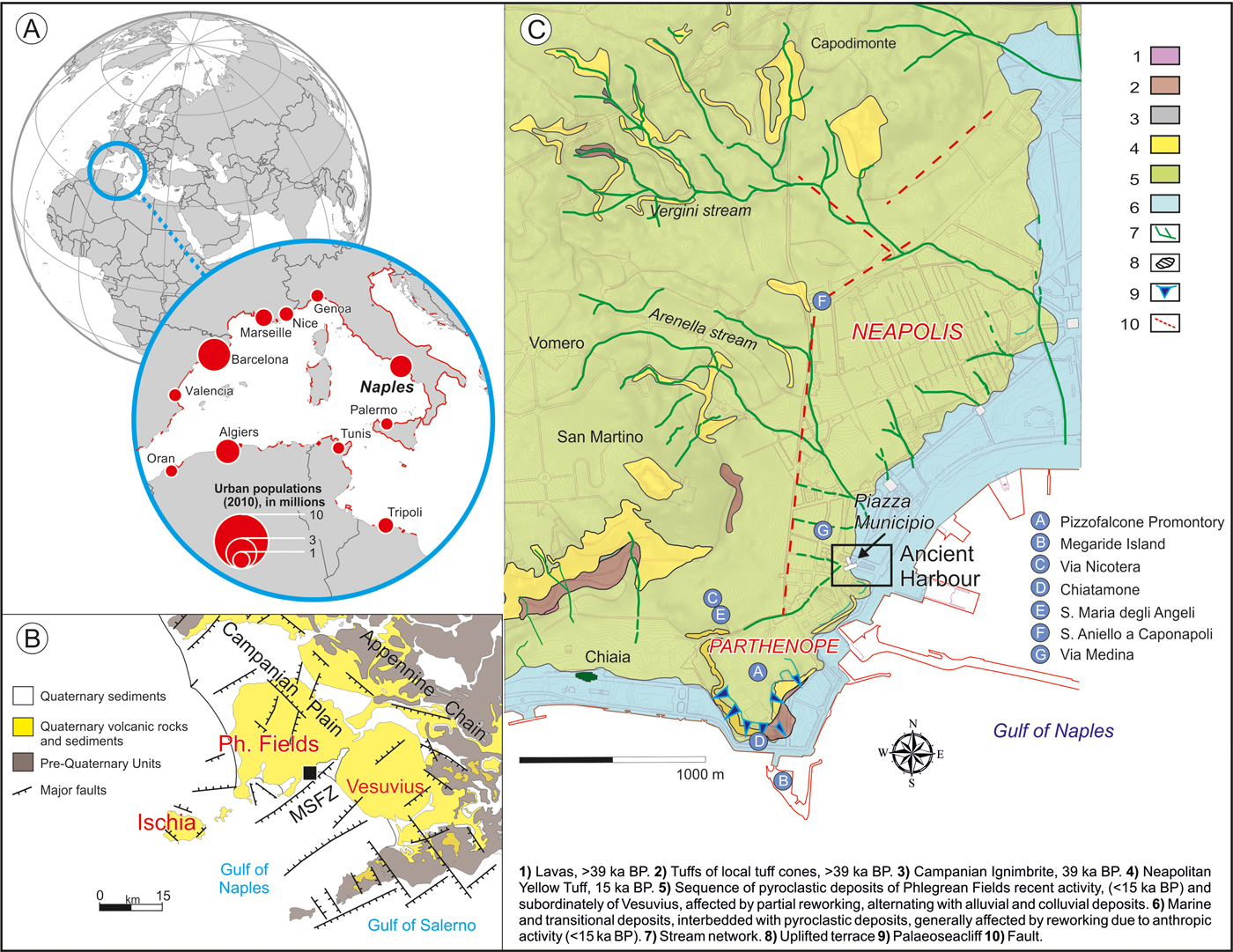
Figure 1. (A) Geographic location of Naples and populations of some key coastal conurbations of the western Mediterranean. The red line indicates hot spots of coastal risk (after Satta et al., Reference Satta, Puddu, Venturini and Giupponi2017). (B) Simplified geologic and tectonic setting of the Gulf of Naples and its hinterland. The black square denotes the location of the study area. MSFZ, Magnaghi–Sebeto Fault Zone; Ph. Fields, Phlegrean Fields. (C) Geomorphological and archaeological setting of Parthenope and Neapolis. The box indicates the location of the ancient harbour. (For interpretation of the references to colour in this figure legend, the reader is referred to the web version of this article.)
This part of the Italian coast lies in a very complex geodynamic setting, and its Holocene geomorphological evolution has primarily been controlled by both tectonics and active volcanism (Fig. 1B, e.g., Milia et al., Reference Milia, Torrente, Giordano and Mirabile2006; Ferranti et al., Reference Ferranti, Antonioli, Anzidei, Monaco and Stocchi2010; Aucelli et al., Reference Aucelli, Cinque, Mattei and Pappone2017b). The aim of this article is to better constrain the role of these factors in the area of Naples, one of the largest coastal conurbations in the Mediterranean. In particular, we aimed to better quantify the timing and magnitude of land-level changes that significantly influenced the rates of RSL variation in the last four millennia.
Many Mediterranean coastal cities have a long history, in some cases extending back thousands of years (e.g., Bini et al., Reference Bini, Fabiani, Pappalardo and Schuldenrein2018). For this reason, the development of methodological approaches adapted to interpretation of geologic and archaeological evidence in urban contexts represents one of the most promising branches of geoarchaeological research (Butzer, Reference Butzer2008; Bini et al., Reference Bini, Fabiani, Pappalardo and Schuldenrein2018). Archaeological remains of harbours and maritime structures have been shown to be important archives of past variations in RSL (e.g., Morhange et al., Reference Morhange, Laborel and Hesnard2001; Anzidei et al., Reference Anzidei, Lambeck, Antonioli, Furlani, Mastronuzzi, Serpelloni and Vannucci2014; Benjamin et al., Reference Benjamin, Rovere, Fontana, Furlani, Vacchi, Inglis and Galili2017), notably for the last three millennia (e.g., Galili et al., Reference Galili, Weinstein-Evron and Ronen1988; Lambeck et al., Reference Lambeck, Anzidei, Antonioli, Benini and Esposito2004; Fontana et al., Reference Fontana, Vinci, Tasca, Mozzi, Vacchi, Bivi and Salvador2017).
The construction of the new Naples underground railway, with a focus on the Piazza Municipio site (Fig. 1C), offered the possibility to study well-preserved harbour structures, often showing fossil traces of biological indicators of past sea levels (e.g., Morhange et al., Reference Morhange, Laborel and Hesnard2001; Morhange and Marriner, Reference Morhange, Marriner, Shennan, Long and Horton2015; Rovere et al., Reference Rovere, Antonioli, Bianchi, Shennan, Long and Horton2015). These proxies were married with new and previously published biostratigraphic data (Liuzza, Reference Liuzza2014; Di Donato et al., Reference Di Donato, Ruello, Liuzza, Carsana, Giampaola, Di Vito, Morhange, Cinque and Russo Ermolli2018), providing fresh insights into the RSL history of this extremely complex coastal area.
STUDY AREA
Geomorphological and tectonic setting
The city of Naples (Italy) constitutes one of the largest coastal conurbations in the western Mediterranean (Fig. 1A; Satta et al., Reference Satta, Puddu, Venturini and Giupponi2017). Its coastal geomorphology is mainly characterized by rocky cliffs and small pocket beaches alternating with densely populated coastal plains (Fig. 1C). This area has a microtidal regime, with a tidal range of ± 0.2 m (Naples Tidal Station; https://www.mareografico.it [accessed 28/11/2018]).
The modern city lies on the westernmost margin of one of these coastal plains (the Campanian Plain) and encompasses a wide area of active volcanism and tectonics between the eastern edge of the nested caldera of the Phlegrean Fields and the Vesuvius stratovolcano apron (Fig. 1B; Di Vito et al., Reference Di Vito, Isaia, Orsi, Southon, De Vita, d'Antonio, Pappalardo and Piochi1999; Milia and Torrente, Reference Milia and Torrente2003; Aucelli et al., Reference Aucelli, Cinque, Mattei and Pappone2017b). The late Pleistocene and Holocene activity of these two volcanic complexes led to the deposition of thick tuff deposits and sequences of pyroclastic fallout and density current deposits (Di Vito et al., Reference Di Vito, Isaia, Orsi, Southon, De Vita, d'Antonio, Pappalardo and Piochi1999; Milia et al., Reference Milia, Torrente, Giordano and Mirabile2006).
The Campanian Plain is developed on top of a 3-km-thick sedimentary sequence filling a Quaternary tectonic depression known as the Campanian Plain Graben (Santangelo et al., Reference Santangelo, Romano, Ascione and Russo Ermolli2017). This plain and its offshore extension have experienced continuous subsidence during the entire Quaternary, at an average rate of ~2 mm/yr (Santangelo et al., Reference Santangelo, Romano, Ascione and Russo Ermolli2017).
The morphology of the city has been significantly controlled by late Quaternary volcanic activity, with a major role played by the Phlegrean Fields (e.g., Aiello and Marsella, Reference Aiello and Marsella2015; Aucelli et al., Reference Aucelli, Cinque, Mattei and Pappone2017b). The current landscape is the result of the mantling of preexisting volcanic edifices by the Neapolitan Yellow Tuff (NYT; 15 ka; Deino et al., Reference Deino, Orsi, de Vita and Piochi2004), the collapse of the related caldera (Phlegrean Fields depression), and, between 15 and 3.8 ka, of the explosive activity of at least 70 monogenetic volcanoes, which generated tuff cones, tuff rings, and widespread Plinian deposits (e.g., Di Vito et al., Reference Di Vito, Isaia, Orsi, Southon, De Vita, d'Antonio, Pappalardo and Piochi1999; Milia and Torrente, Reference Milia and Torrente2003).
The intense volcano-tectonic activity also resulted in a number of fault scarps (mainly southwest–northeast and northwest–southeast) that are widespread across the study area (e.g., Orsi et al., Reference Orsi, Di Vito and Isaia2004; Cinque et al., Reference Cinque, Irollo, Romano, Ruello, Amato and Giampaola2011; Romano et al., Reference Romano, Di Vito, Giampaola, Cinque, Bartoli, Boenzi and Detta2013; Fig. 1B), including within the Phlegrean Fields caldera, in the Gulf of Naples, and the Campanian Plain (Di Vito et al., Reference Di Vito, Isaia, Orsi, Southon, De Vita, d'Antonio, Pappalardo and Piochi1999; Bruno et al., Reference Bruno, Rapolla and Di Fiore2003; Cinque et al., Reference Cinque, Irollo, Romano, Ruello, Amato and Giampaola2011). A major fault zone (the Magnaghi–Sebeto Fault Zone [MSFZ], Fig. 1B; Bruno et al., Reference Bruno, Rapolla and Di Fiore2003), occurs in the mid- to northern portion of the gulf with alternating northeast–southwest and east–west trending segments. The MSFZ bounds the subsiding Sebeto Plain, where subsidence rates of 1.5–2 mm/yr have been estimated for the late Holocene (Cinque et al., Reference Cinque, Irollo, Romano, Ruello, Amato and Giampaola2011; Aucelli et al., Reference Aucelli, Cinque, Mattei, Pappone and Rizzo2019).
Archaeological setting
In the Naples area, evidence for human occupation dates back to the late Neolithic and the Eneolithic period (Giampaola and Boenzi, Reference Giampaola, Boenzi, Di Vito and de Vita2013), as indicated by a sequence of plow zones associated with traces of human occupation, which was found intercalated in volcanic deposits attributed to the Pigna S. Nicola (9.2–9.5 ka) and Agnano-Monte Spina (4.5–4.6 ka) eruptions (Di Vito et al., Reference Di Vito, Isaia, Orsi, Southon, De Vita, d'Antonio, Pappalardo and Piochi1999; Smith et al., Reference Smith, Isaia and Pearce2011).
There is evidence for the occupation of a large coastal area west of Pizzofalcone promontory, on the Castel Nuovo heights and at the margin of the Neapolis plateau (Fig. 1C) in the Early Bronze Age (twenty-first century to twentieth century BC, 4.0 to 3.9 ka). Despite the interruption caused by the Pomici di Avellino eruption (twentieth century BC), which largely concerned the Naples area, evidence of a persistent coastal occupation was also found in the Middle Bronze Age (seventeenth century to fourteenth century BC, 3.6 to 3.3ka) and, at some sites, until the Late Bronze Age (Giampaola and Boenzi, Reference Giampaola, Boenzi, Di Vito and de Vita2013; Romano et al., Reference Romano, Di Vito, Giampaola, Cinque, Bartoli, Boenzi and Detta2013; Di Vito et al., Reference Di Vito, Talamo, de Vita, Rucco, Zanchetta and Cesarano2019). However, the most important coastal occupation of the area started in the eighth century to seventh century BC (2.6–2.7 ka), when Greek colonists founded an epineion (harbour) named Parthenope. This was placed at the foot of San Martino hill, on the promontory of Pizzofalcone and on the Megaride island (Fig. 1C): the only archaeological evidence for this ancient centre is the necropolis of via Nicotera and the ceramic material of Chiatamone and the S. Maria degli Angeli dump (end of the eighth century to fifth century BC; 2.7–2.4 ka; Cinquantaquattro, Reference Cinquantaquattro2015; Giampaola, Reference Giampaola, Osanna and Rescigno2017; Fig. 1C). Parthenope survived as a minor centre named Palaepolis (old-polis) until the fourth–third centuries BC (2.3–2.2 ka). At the end of the sixth to the beginning of fifth century BC (~2.5 ka), a new-polis, Neapolis, was founded at the eastern edge of Parthenope (e.g., D'Agostino and Giampaola, Reference D'Agostino and Giampaola2005) on a gently sloping and rounded plateau (Fig. 1C). Neapolis developed continuously from the end of the sixth century BC (~2.5 ka) to the end of the fifth century AD (~1.5 ka).
Reconstruction of the ancient coastal landscape revealed the presence of a bay between Neapolis and Parthenope (Carsana et al., Reference Carsana, Febbraro, Giampaola, Guastaferro, Irollo and Ruello2009; Liuzza, Reference Liuzza2014; Di Donato et al., Reference Di Donato, Ruello, Liuzza, Carsana, Giampaola, Di Vito, Morhange, Cinque and Russo Ermolli2018). On the margin of this bay, a sheltered basin existed in the area between Piazza Municipio and Via Medina (Fig. 1C). The archaeological excavations of the Municipio underground station (Fig. 1C) clearly indicated the presence of the ancient harbour since at least the third century BC (~2.2 ka), when intensive dredging of the sea bottom (Fig. 2A) removed almost all the older sediments and the first maritime structures were built (e.g., Giampaola and Carsana, Reference Giampaola, Carsana and Lo Sardo2005; Carsana et al., Reference Carsana, Febbraro, Giampaola, Guastaferro, Irollo and Ruello2009; Morhange and Marriner, Reference Morhange and Marriner2010). However, the recovery of residual ceramics dated to the eighth and seventh centuries BC (2.7–2.6 ka), as well as the presence of nondredged marine sediments, dated from the end of sixth to the end of fifth century BC (2.5–2.4 ka), suggest that the area of Piazza Municipio was already used as a harbour at the time of Parthenope and at the foundation of Neapolis (Giampaola, Reference Giampaola, Osanna and Rescigno2017). Many buried harbour structures (i.e., piers, quays, ramps, and walls; Fig. 2A and B) were discovered during archaeological excavations, often including fossil remains of biological indicators attached to former structures (Liuzza, Reference Liuzza2014; Di Donato et al., Reference Di Donato, Ruello, Liuzza, Carsana, Giampaola, Di Vito, Morhange, Cinque and Russo Ermolli2018). The Piazza Municipio excavation further revealed a unique series of shipwrecks dated to the second century BC (2.1 ka), wrecks E and H in Figure 2A; the end of the first century AD (1.9 ka), wrecks A and C, in Figure 2B; and the end of the second century/beginning of the third century AD (1.8 ka), wrecks B, F, and G, in Figure 2B (Giampaola et al., Reference Giampaola, Carsana, Boetto, Crema, Florio, Panza and Pizzo2006; Boetto, Reference Boetto and Bockius2009; Boetto and Poveda, Reference Boetto, Poveda, Boetto and Rieth2018).

Figure 2. (A) Main archaeological findings of the Hellenistic period. The position of the ramp is indicated together with details of the dredging operations (after Di Donato et al., Reference Di Donato, Ruello, Liuzza, Carsana, Giampaola, Di Vito, Morhange, Cinque and Russo Ermolli2018). (B) Main archaeological findings of the Roman period. The position of the pier and the quay are indicated together with the location of the first- and second-century AD shipwrecks (after Di Donato et al., Reference Di Donato, Ruello, Liuzza, Carsana, Giampaola, Di Vito, Morhange, Cinque and Russo Ermolli2018). Black dots indicate the location of the sections V2a, Top and Act. (see Fig. 4). Photo credits: the Soprintendenza Archeologia, Belle arti e Paesaggio per il comune di Napoli. The reconstructed palaeo shoreline (blue dashed line) and the palaeo marine basin of the harbour (blue shaded area) are also shown. (For interpretation of the references to colour in this figure legend, the reader is referred to the web version of this article.)
METHODS
RSL proxies
The accuracy of the RSL reconstruction using coastal archaeological remains depends on understanding the relationship between the coastal structure and the contemporary mean sea level (msl; e.g., Morhange and Marriner, Reference Morhange, Marriner, Shennan, Long and Horton2015), which significantly improves when fossil remains of attached biological indicators are present (e.g., Laborel and Laborel-Deguen, Reference Laborel and Laborel-Deguen1994; Morhange et al., Reference Morhange, Laborel and Hesnard2001; Morhange and Marriner, Reference Morhange, Marriner, Shennan, Long and Horton2015). Several studies have demonstrated that a precise analysis of the biological zone (cf. Laborel and Laborel-Deguen, Reference Laborel and Laborel-Deguen1994) found on archaeological structures may lead to a very precise assessment (up to ± 0.1 m) of the former RSL (e.g., Morhange et al., Reference Morhange, Laborel and Hesnard2001, Reference Morhange, Marriner, Excoffon, Bonnet, Flaux, Zibrowius, Goiran and Amouri2013; Morhange and Marriner, Reference Morhange, Marriner, Shennan, Long and Horton2015).
In this study, we analysed the biological assemblages found on harbour structures. These assemblages are composed of encrusting species such as vermetids and Ostrea spp. The upper limit of the living zone of these species delineates the biological mean sea level (bmsl; Morhange and Marriner, Reference Morhange, Marriner, Shennan, Long and Horton2015; Rovere et al., Reference Rovere, Antonioli, Bianchi, Shennan, Long and Horton2015). The bmsl is not a perfect horizontal line but is naturally warped, even over short distances, because of local variations in hydrodynamics and morphology (Vacchi et al., Reference Vacchi, Marriner, Morhange, Spada, Fontana and Rovere2016). However, in the microtidal Mediterranean setting, bmsl occupies the lower part of the tidal range (i.e., from mean low water [MLW] to the msl; Laborel and Laborel-Deguen, Reference Laborel and Laborel-Deguen1994; Rovere et al., Reference Rovere, Antonioli, Bianchi, Shennan, Long and Horton2015). For this reason, these biological markers are often used to produce very accurate RSL index points (i.e., a point that constrains the palaeo-RSL in space and time; van de Plassche, Reference van de Plassche1982), notably in the Mediterranean Sea (Morhange et al., Reference Morhange, Laborel and Hesnard2001, Reference Morhange, Marriner, Excoffon, Bonnet, Flaux, Zibrowius, Goiran and Amouri2013; Vacchi et al., Reference Vacchi, Ghilardi, Melis, Spada, Giaime, Marriner, Lorscheid, Morhange, Burjachs and Rovere2018).
Following Shennan et al. (Reference Shennan, Long and Horton2015), we estimated the palaeo-RSL position according to the following equation:
 $$RSL_i = A_i-RWL_i$$
where A is the elevation of the sample i, and RWL is the reference water level (i.e., the midpoint of the indicative range of the sample i; see Table 1).
Table 1. Index and limiting points used to reconstruct the relative sea-level (RSL) evolution of the ancient harbour of Naples. The stratigraphic age is given by the archaeological content of the deposit. The calibration of the 14C age of the Balanophyllia sp. samples was performed using the ∆R value of 69 ± 40 (Siani et al., Reference Siani, Paterne, Arnold, Bard, Métivier, Tisnerat and Bassinot2000). IR, indicative range; MHW, mean high water; MLW, mean low water; msl, mean sea level.

Apart from the sediments and structures of the Hellenistic and Roman harbour, marine sands overlying the tufaceous bedrock and related to ancient marine bottoms were identified between 5.1 and 3.7 m below msl (Giampaola, Reference Giampaola2018). These sediments were investigated by means of an integrated approach including granulometric and palaeontological analyses, which allowed us to define the depositional environments. In particular, the palaeoecological interpretation of fossil assemblages was based on the present ecology of the identified mollusk taxa. A more detailed description of these methodologies is provided in Di Donato et al. (Reference Di Donato, Ruello, Liuzza, Carsana, Giampaola, Di Vito, Morhange, Cinque and Russo Ermolli2018). The marine biofacies do not represent an accurate RSL proxy because they can only constrain the RSL above a datum. However, they can be transformed into marine limiting points to help probe changes in RSL through time and to estimate the directions and the rates of these changes (Shennan et al., Reference Shennan, Long and Horton2015).
Chronological constraints
The age of both RSL index and limiting points is constrained by the archaeological dating of both the harbour structures (Boetto et al., Reference Boetto, Carsana and Giampaola2010; Giampaola, Reference Giampaola, Osanna and Rescigno2017) and the sedimentary units (Di Donato et al., Reference Di Donato, Ruello, Liuzza, Carsana, Giampaola, Di Vito, Morhange, Cinque and Russo Ermolli2018). The latter is based on the archaeological content (mainly pottery) of the marine/lagoon sequences found in the harbour basin. This pottery is often well preserved and comprises goods and ship equipment lost during loading and unloading operations in the harbour, in addition to waste from the surrounding urban area (Di Donato et al., Reference Di Donato, Ruello, Liuzza, Carsana, Giampaola, Di Vito, Morhange, Cinque and Russo Ermolli2018). The chronological error associated with this kind of material ranges between 50 and 100 yr.
In order to improve the chronology, we acquired two new 14C dates on in situ fossil corals (Balanophyllia spp.) found at the base of the stratigraphic sequence. These corals were in living position on the tufaceous bedrock. The samples were calibrated using CALIB 7.1 (Stuiver et al., Reference Stuiver, Reimer and Reimer2019) and the Marine13 calibration curve (Reimer et al., Reference Reimer, Bard, Bayliss, Beck, Blackwell, Ramsey and Buck2013) with a ∆R of 69 ± 40 (Siani et al., Reference Siani, Paterne, Arnold, Bard, Métivier, Tisnerat and Bassinot2000). All vertical measurements were undertaken using a Leica DGPS (differential GPS) relative to the current msl with a precision of 0.05 m.
Isostatic and tectonic contributions to the RSL record
For the late Holocene period (i.e., last 4.0 ka), the ice-equivalent meltwater is either zero or minimal (Milne et al., Reference Milne, Long and Bassett2005; Church et al., Reference Church, White, Aarup, Wilson, Woodworth, Domingues, Hunter and Lambeck2008). Therefore, changes observed in RSL are dominated by vertical land movements because of glacio- and hydro-isostatic adjustment (GIA). In tectonically active areas, the GIA related land-level changes can be accentuated or counterbalanced by ground movements (e.g., Anzidei et al., Reference Anzidei, Lambeck, Antonioli, Furlani, Mastronuzzi, Serpelloni and Vannucci2014; Vacchi et al., Reference Vacchi, Rovere, Chatzipetros, Zouros and Firpo2014; Kolaiti et al., Reference Kolaiti, Papadopoulos, Morhange, Vacchi, Triantafyllou and Mourtzas2017)
In order to better quantify these vertical components, we compared the reconstructed RSL record with the following GIA predictions available for the Gulf of Naples: (1) the ICE-5 G VM2 (Peltier, Reference Peltier2004) GIA prediction computed in Vacchi et al. (Reference Vacchi, Marriner, Morhange, Spada, Fontana and Rovere2016) using the “sea-level equation” solver SELEN (Spada and Stocchi, Reference Spada and Stocchi2007); and (2) the K33_j1b_WS9_6 GIA prediction computed in the Gulf of Naples by Lambeck et al. (Reference Lambeck, Antonioli, Anzidei, Ferranti, Leoni, Scicchitano and Silenzi2011). This comparison allowed us to factor-out the GIA-related land-level changes from the reconstructed RSL history in order to assess the role of tectonic contributions for different historical periods.
RESULTS
The archaeological findings (Fig. 3) coupled with the analysis of sedimentary sequences and microfaunal remains (Lines 1 and 6 and Area 4, Fig. 2A and B; Fig. 4) have yielded evidence for ~4000 yr of RSL evolution at the Piazza Municipio site. The results are presented in chronological order from the oldest to the most recent.
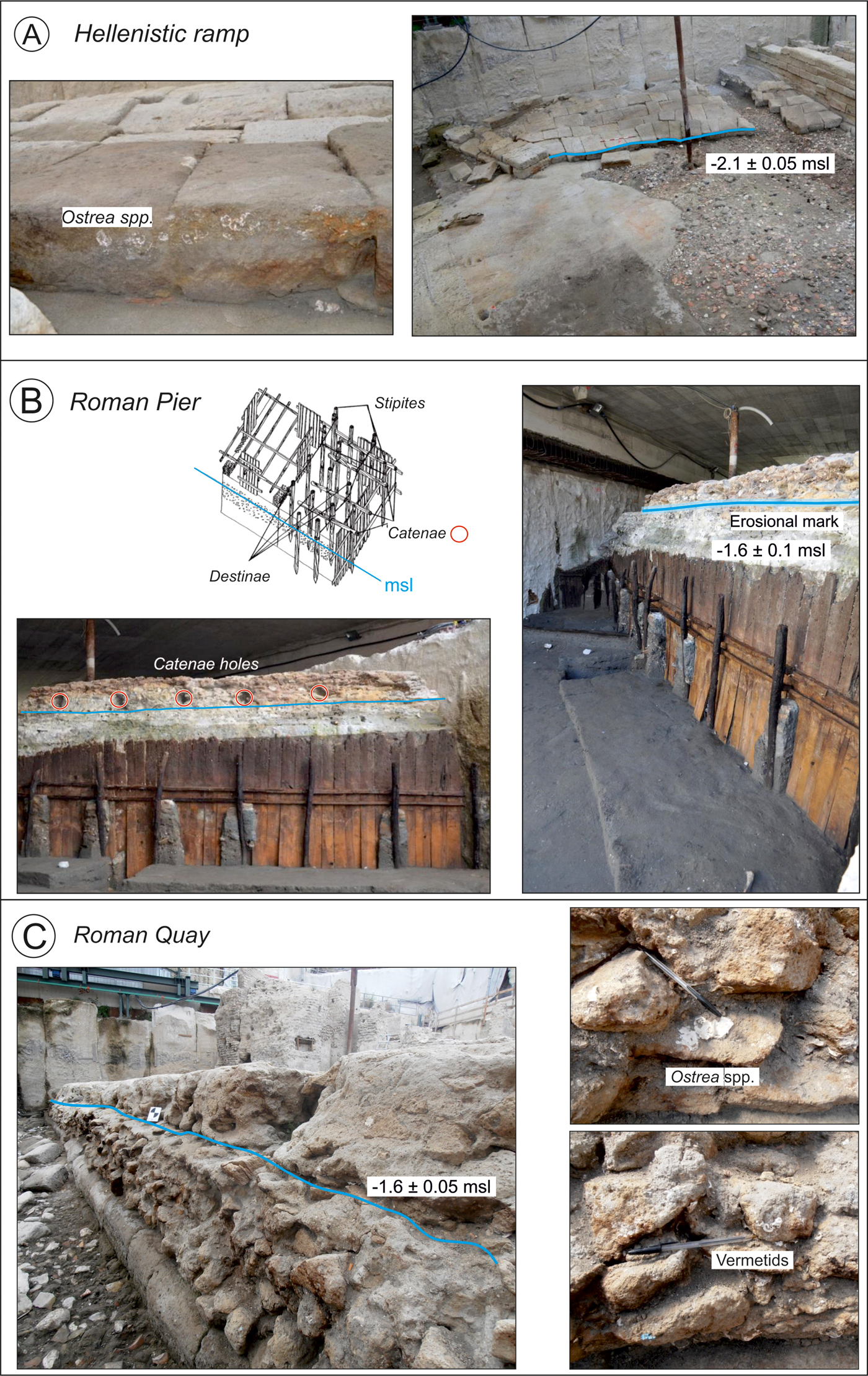
Figure 3. (A) Upper limit (blue line) of fixed biological indicators (Ostrea spp.) found on the Hellenistic ramp. (B) Positions of the erosional mark (blue line) and the catenae holes (red circles) on the Augustan pier. The panel also shows the general formwork of Roman concrete harbours (after Felici, Reference Felici and Volpe1998). (C) Upper limit (blue line) of fixed biological indicators (Ostrea spp. and vermetids) found on the Roman quay. msl, mean sea level. Photo credits: the Soprintendenza Archeologia, Belle arti e Paesaggio per il comune di Napoli. (For interpretation of the references to colour in this figure legend, the reader is referred to the web version of this article.)

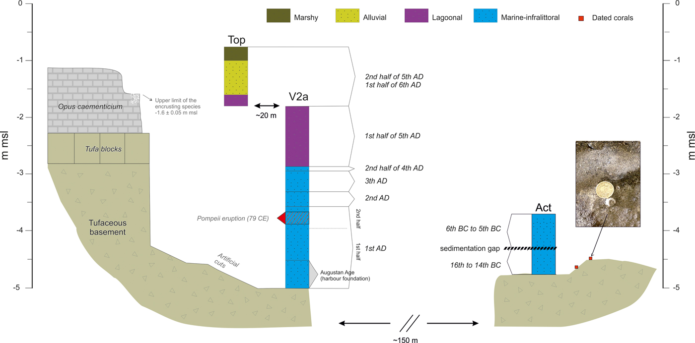
Figure 4. (colour online) Chronostratigraphic sequence of the palaeoenvironments elucidated in the Act, V2a, and Top sections. See Figure 2B for the location of the sections in the Naples harbour basin. msl, mean sea level.
Bronze Age period
The rocky seafloor outcrops at the base of the sedimentary sequence of the harbour basin. It is composed of yellow tuff and is widely colonized by benthic species including bivalves, corals, and serpulids. At 4.6 and 4.5 m below msl, two corals (Balanophyllia sp.) were found in living position on rocky outcrops (Fig. 4). This coral, widespread in the Mediterranean, is typical of the upper infralittoral zone (Goffredo et al., Reference Goffredo, Mezzomonaco and Zaccanti2004). The two samples yielded very coherent ages of 1961 ± 157 and 1818 ± 150 cal yr BC (approximately twentieth century to approximately nineteenth century BC, the final phase of the Early Bronze Age; Table 1). Marine sediments overlie the basal rocky seafloor until 4.25 m below msl. These comprise coarse-to-medium, poorly sorted sands characterised by a slight fining upward trend. Benthic foraminifera assemblages are mostly represented by taxa that are presently widespread in infralittoral vegetated seafloors of the Gulf of Naples (Sgarrella and Moncharmont-Zei, Reference Sgarrella and Moncharmont-Zei1993) such as Cibicides lobatulus, Elphidium crispum, Elphidium macellum, Rosalina spp., and, among the miliolids, Quinqueloculina pseudobuchiana, Miliolinella spp., and Siphonaperta spp. Vermetids are also abundant in the wash residues. The abundance of archaeological material allowed these infralittoral units to be attributed to the Middle Bronze Age (MBA 1–2 and 3, sixteenth to fourteenth centuries BC; Table 1).
Greek period
A further marine unit overlies the MBA sediments up to 3.7 m below msl. This unit, similar to the MBA unit in grain size and faunal assemblages, showed an upwards coarsening trend. The dating of the archaeological material found in this unit yielded Archaic ages (end of the sixth century to end of the fifth century BC; Table 1). This implies an ~800 yr gap (from 1300 to 500 BC) in sedimentation in this marine unit (Fig. 4). The causes of this hiatus are unclear (see Discussion section) but could be ascribed to drift erosion.
At about 2 m below msl, the first large archaeological harbour structure was observed. This is a gently sloping surface that is ~12 m long and made of squared blocks (Figs. 2A and 3A). The top and the bottom of this structure are placed at 1.53 m and at 2.25 m below msl, respectively. This structure, composed of large tuff blocks, lies on a sandy bottom containing marine-shell remains, Posidonia oceanica seagrass, and ceramic fragments (Fig. 3A). The archaeological excavation indicates that this structure was in use during the Hellenistic period (end of the third century to second century BC; Table 1) and was likely used as a ramp or slipway. The maritime characteristics of this structure are further attested by fossil remains of Ostrea spp. found at its seaward end (Fig. 3A). The upper limit of the marine shell encrustation was measured at 2.1 m ± 0.05 m below msl and is buried by late third-century BC sands. The remains of two Hellenistic shipwrecks were also found lying on the seabed of the bay (Fig. 2A).
Roman period
In the first century AD, several large harbour structures were built to serve the rapidly expanding Roman Naples. These infrastructures were intended to provide a better-protected cove in order to improve accessibility and navigability. At that time, the seafloor reached maximal depths of 5 to 6 m, as testified by evidence for dredging of the tufaceous substrate (NYT). A small islet at the cove entrance (Fig. 2B) was used as a base for a large pier (Fig. 3B) that was probably built to protect the internal part of the harbour from the southern swell. In the western part of the cove, a perfectly preserved quay was also found (Figs. 2B and 3C).
The low-energy harbour environment has recorded the progressive silting of the basin. The marine stratigraphy (Fig. 4), precisely dated using the archaeological content (mainly pottery), yielded ages ranging from the Augustan (end of the first century BC to beginning of the first century AD) to the late Roman periods (fifth century AD; Di Donato et al., Reference Di Donato, Ruello, Liuzza, Carsana, Giampaola, Di Vito, Morhange, Cinque and Russo Ermolli2018). Additional chronological constraints were provided by five shipwrecks found in the harbour basin (Boetto et al., Reference Boetto, Carsana and Giampaola2010, Boetto and Poveda, Reference Boetto, Poveda, Boetto and Rieth2018). They were dated from the end of the first to the beginning of the third century AD (Fig. 2B).
The concrete pier
On the southeastern side of the harbour basin, the remains of an impressive pier, ~360 m2 in area and composed of two arms, was observed (Fig. 2B). The pier was built using a wooden frame filled with opus caementicium (hydraulic cement; Brandon et al., Reference Brandon, Hohlfelder, Jackson and Oleson2014). Its top was measured from 0.7 to 1.15 m below msl. The lower part of the pier, at 4 m below msl, shows the preserved wooden planks (stipites) of the formwork wedged in sandy sediments dated to the second half of the first century BC (Table 1).
In the concrete infilling, above the stipites, holes testify to the presence of catenae (Fig. 3B). Above each of the stipites, holes hosting the catenae are observed (Fig. 3B). Catenae are horizontal wooden beams that were used to contain the external thrusts during harbour construction and, notably, during the consolidation phase of the hydraulic cement (Felici, Reference Felici and Volpe1998; Brandon et al., Reference Brandon, Hohlfelder, Jackson and Oleson2014). About 10 cm below the catenae holes, a long and continuous erosional mark can be observed along the whole length of the pier. It has a generally horizontal shape and was measured at 1.6 ± 0.1 m below msl (Fig. 3B).
On the western side of the harbour basin, a large quay, ~24.5 m long and ~6.5 m wide, was found (Fig. 2B). The quay is made of opus caementicium overlying one or two rows of large tuff blocks placed directly above the tuff substrate (Fig. 3C). The top of the quay (the walkable surface) is not uniform and was measured at elevations ranging between 0.8 and 1.2 m below msl. The base of the quay lies in direct contact with the tuff substrate. Below this, evidence of artificial scars cut into the tufaceous substrate was observed down to 5 m below msl, close to the quay. These scars are coeval with the foundation of the quay, as robustly demonstrated by the thick (~1.4 m) sedimentary layer, which was found above the top of the hand-cut tuff substrate (Fig. 4). The multiproxy analysis of the lowest part of the stratigraphic sequence (Di Donato et al., Reference Di Donato, Ruello, Liuzza, Carsana, Giampaola, Di Vito, Morhange, Cinque and Russo Ermolli2018; Fig. 4) indicates an infralittoral environment dated to the first century AD (Table 1). At 3.85 m below msl, this unit is abruptly truncated by a pyroclastic layer, 0.2 m thick, associated with the AD 79 Pompeii eruption (Di Donato et al., Reference Di Donato, Ruello, Liuzza, Carsana, Giampaola, Di Vito, Morhange, Cinque and Russo Ermolli2018).
Above this layer, another marine infralittoral sequence (Liuzza, Reference Liuzza2014; Di Donato et al., Reference Di Donato, Ruello, Liuzza, Carsana, Giampaola, Di Vito, Morhange, Cinque and Russo Ermolli2018) develops for ~0.75 m. This sequence, extremely rich in archaeological remains, was dated from the end of the second century to the end of the fourth century AD. At 2.8 m below msl, a transition to a shallow water lagoon environment is indicated by both a decrease in the sediment grain size and by a sudden increase in lagoon microfauna (Di Donato et al., Reference Di Donato, Ruello, Liuzza, Carsana, Giampaola, Di Vito, Morhange, Cinque and Russo Ermolli2018). This unit was dated to the first half of the fifth century AD, and its top was measured at 1.8 m below msl (Liuzza, Reference Liuzza2014; Di Donato et al., Reference Di Donato, Ruello, Liuzza, Carsana, Giampaola, Di Vito, Morhange, Cinque and Russo Ermolli2018).
On the quay structure, a significant population of encrusting fossil species (mainly Ostrea and vermetids; Fig. 3C) was observed (Liuzza, Reference Liuzza2014). They are widespread on the archaeological structure, and their upper limit (Fig. 3C) was measured at 1.60 ± 0.05 m below msl. The colonization by this attached marine organism was interrupted by the progressive silting of the quay area, before being sealed by sediments dated to the first half of the fifth century AD (Table 1).
Late Roman and medieval periods
The Roman harbour basin shows evidence for progressive silting throughout antiquity. During the excavation, the quay structure was found covered by a sandy to gravelly beach deposit rich in marine-shell debris (mainly Loripes lucinalis, Paphia aurea, Bittium reticulatum, Tapes decussatus, and Cerithium vulgatum) mixed with abundant vegetal remains (e.g., nutshells, almonds, and seeds; Liuzza, Reference Liuzza2014). Furthermore, this deposit is full of anthropogenic remains such as ceramics and glass fragments, pieces of mosaic, and traces of iron and lead (Liuzza, Reference Liuzza2014). In some cases, the sandy sediments show plane parallel bedding or a foreset stratification. This palaeobeach was archeologically dated to the end of the fifth century to the beginning of the sixth century AD (Table 1) and was found at elevations of 1 ± 0.2 m below msl (Liuzza, Reference Liuzza2014). A further indicator of the late-Roman evolution of the harbour basin is the presence, in Line 6 of the excavation area (Fig. 2B), of a beachface deposit at 1.3 ± 0.2 m below msl. This deposit, dated to the sixth century AD (Table 1), is bordered by small juniper trees (Juniperus spp.) found in living position (Barone, M.R., University of Naples, personal communication) and extending for about 13 m.
Finally, on the top portion of the Roman pier (Fig. 2B), there is evidence of biological encrustations (mainly Ostrea sp.) up to 0.7 m below msl. These encrustations continued to colonize the structure after the end of the operational period. They were sealed by sediments dating to the thirteenth century to fourteenth century AD (Table 1).
DISCUSSION
New constraints on the RSL history of the ancient harbour of Naples
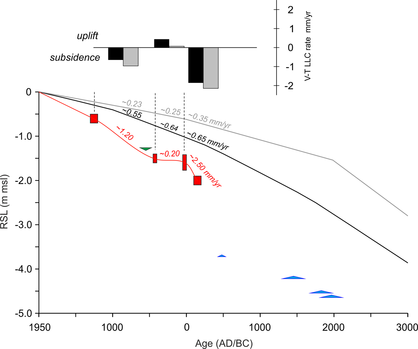
The multiproxy analysis of sediments from the ancient Gulf of Naples provides new constraints on the RSL evolution of the area (Fig. 5). Between ~2000 and ~500 BC, the RSL is loosely constrained by the sole presence of marine limiting points. The oldest data, represented by the fossil corals, constrain the RSL position to above ~4.5 m below msl at ~1800 BC (Fig. 5).

Figure 5. Reconstruction of the relative sea-level (RSL) changes rates in the ancient harbour of Naples. Red boxes are RSL index points, and dark green and blue triangles are terrestrial and marine limiting points, respectively. The dimensions of boxes and lines are based on elevation and age errors. Red line represents the best fit of the RSL index points. Grey and black lines are the glacio- and hydro-isostatic adjustment prediction for the Gulf of Naples according to the ICE-5 G VM2 model (Peltier, Reference Peltier2004) and the K33_j1b_WS9_6 model (Lambeck et al., Reference Lambeck, Antonioli, Anzidei, Ferranti, Leoni, Scicchitano and Silenzi2011), respectively. Numbers indicate the average RSL rising rates in the time span delimited by the dashed lines. Histograms represent the net rates of land-level change associated with the volcano-tectonic component (V-T LLC) calculated using the ICE-5 G VM2 model (Peltier, Reference Peltier2004; grey bars) and the K33_j1b_WS9_6 model (Lambeck et al., Reference Lambeck, Antonioli, Anzidei, Ferranti, Leoni, Scicchitano and Silenzi2011; black bars). msl, mean sea level. (For interpretation of the references to colour in this figure legend, the reader is referred to the web version of this article.)
The benthic assemblages of the overlying infralittoral marine sediments testify to the occurrence of seafloors with Posidonia oceanica meadows throughout the Bronze and Archaic Age periods. The living range of this endemic Mediterranean seagrass is wide (0 to 40 m below msl; Vacchi et al., Reference Vacchi, De Falco, Simeone, Montefalcone, Morri, Ferrari and Bianchi2017), and therefore, these marine sediments only constrain the RSL above 4.25 m below msl at ~1400 BC and above 3.7 m below msl at ~500 BC (Fig. 5). It is worth noting the absence of sedimentation between the fourteenth century and the sixth century BC. The causes of this ~800 yr hiatus are unclear. A possible explanation may be related to the position of this sedimentary sequence, which is located in the most external part of the basin, near the small rocky islet (Fig. 2B). Changes in the nearshore hydrodynamics, triggered by the period of increased Mediterranean storminess recorded between ~1600 and ~600 BC (e.g., Sabatier et al., Reference Sabatier, Dezileau, Colin, Briqueu, Bouchette, Martinez, Siani, Raynal and Von Grafenstein2012; Marriner et al., Reference Marriner, Kaniewski, Morhange, Flaux, Giaime, Vacchi and Goff2017), may have produced increased erosion in the outer part of the basin. However, this hypothesis requires more detailed investigations to understand the environmental setting of the basin before the foundation of the harbour.
The oldest RSL index point is provided by the biological encrustation found on the Hellenistic ramp. In low-energy harbour settings, the upper limit of Ostrea sp. occurs in the lower part of the intertidal zone (MLW to msl, Table 1; Laborel and Laborel-Deguen, Reference Laborel and Laborel-Deguen1994; Morhange et al., Reference Morhange, Marriner, Excoffon, Bonnet, Flaux, Zibrowius, Goiran and Amouri2013; Morhange and Marriner, Reference Morhange, Marriner, Shennan, Long and Horton2015). Once corrected for the indicative meaning, it precisely constrains the RSL position to 2.0 ± 0.1 m below msl during the Hellenistic period (150 ± 50 BC; Table 1, Fig. 5).
The majority of the harbour structures are dated to the Roman period. In particular, the quay and the pier are both attributed to the Augustan period (end first century BC - beginning first century AD; Giampaola Reference Giampaola, Osanna and Rescigno2017, Reference Giampaola2018). The presence of catenae holes ~0.1 m above well-developed erosional marks, observed along the whole length of the pier, provides insights into the RSL position at the time of the harbour foundation. According to Vitruvius (“de Architectura,” ~20 BC), the catenae (Fig. 3B) were placed slightly above the sea surface (Felici, Reference Felici and Volpe1998; Oleson, Reference Oleson1988; Mattei et al., Reference Mattei, Troisi, Aucelli, Pappone, Peluso and Stefanile2018). Thus, these features suggest an RSL position of 1.6 ± 0.2 m below msl during the first half of the first century AD (AD 25 ± 25; Table 1, Fig. 5).
Furthermore, the thick layer of harbour deposits found above the artificially cut basement in front of the quay (Fig. 4) offers additional insights into the RSL position to the first century AD. These marine sediments are sealed at the top (3.65 m below msl) by volcanic ash and marine remains attributed to the Plinian eruption of AD 79. In sum, this represents the harbour seafloor in the second part of the first century AD. The larger sailing ship found in the harbour (Napoli A, Fig. 2B) was 14.25 m long. If we add this ship draft (~2 m) to the palaeoseafloor, we obtain a value of ~1.65 m below msl. The ship draught alone cannot be considered a robust proxy for RSL reconstruction (e.g., Morhange and Marriner, Reference Morhange, Marriner, Shennan, Long and Horton2015). However, the reconstructed sea-level agrees with the RSL position (1.6 ± 0.2 m below msl) indicated by the erosional mark on the pier.
The RSL insights that can be extracted from the analysis of the harbour structures are not limited to the first century AD. On the quay, several traces of encrusting fossil organisms were observed (Fig. 3C). Their upper limit cannot be related to the harbour foundation period because the top of the structure was found sealed by sediments dating to the first half of the fifth century AD. The stratigraphic sequence observed in Piazza Municipio (Di Donato et al., Reference Di Donato, Ruello, Liuzza, Carsana, Giampaola, Di Vito, Morhange, Cinque and Russo Ermolli2018; Fig. 4) documents the progressive silting of the harbour basin between the first century and the sixth century AD. The upper layer of benthic organisms was killed by the progressive reduction of the water column and by deposition of lagoonal sediments that buried the attached bioindicators in the first half of the fifth century AD. Thus, the upper limit of the attached biological indicators, once corrected for the indicative meaning, robustly constrains the RSL to 1.5 ± 0.1 m below msl at AD 425 ± 25. This RSL position agrees with the coeval supratidal beach evidence, which constrains the RSL to below 1 ± 0.1 below msl (Fig. 5).
Similarly, evidence of fossil benthic organisms was observed up to the top of the Augustan pier (i.e., on the walkable surface at −0.7 m asl). These fossil biological remains are clearly not related to the functioning period of the pier because the walkable surface of Roman piers was usually at least 0.4 m above the palaeo-msl (see Auriemma and Solinas, Reference Auriemma and Solinas2009). Furthermore, these biological encrustations are sealed by a stratigraphic unit dated to the thirteenth century to fourteenth century AD. Once corrected for the indicative meaning, this index point constrains the RSL to 0.6 ± 0.1 below msl at AD 1250 ± 50 (Fig. 5).
The new data set of index and limiting points (Table 1, Fig. 5) provides fresh insights into the RSL history of the ancient harbour of Naples during the last ~4 ka. Our data show that the total RSL variation was within 4.5 m below msl. Index points robustly constrain a RSL rise of ~0.5 m in ~200 yr (Fig. 5, Table 1) at rates of ~2.5 mm/yr. RSL rates showed a significant deceleration from the first century AD to the fifth century AD (Fig. 5). During this time period, the RSL stabilized at 1.6 ± 0.1 to 1.5 ± 0.1 m below msl implying a negligible rate of rise (Fig. 5). Such RSL stabilization ended in the post-Antiquity period. In fact, the youngest index point (0.6 ± 0.1 m below msl at AD ~1250; Table 1) documents the reacceleration of rising rates during the medieval period with rates of ~1.2 mm/yr (Fig. 5).
Volcano-tectonic effects on the RSL history of the ancient port of Naples
As stated previously, for the late Holocene period (i.e., last 4.0 ka), the postglacial ice equivalent meltwater input is minor (Milne et al., Reference Milne, Long and Bassett2005; Khan et al., Reference Khan, Ashe, Shaw, Vacchi, Walker, Peltier, Kopp and Horton2015). Moreover, our suite of RSL index points comprises mostly uncompressible material, rendering the effects of compaction negligible. For these reasons, any change observed in our RSL record is the sum of vertical land movements because of GIA and volcano-tectonics (Ferranti et al., Reference Ferranti, Antonioli, Anzidei, Monaco and Stocchi2010; Cinque et al., Reference Cinque, Irollo, Romano, Ruello, Amato and Giampaola2011; Aucelli et al., Reference Aucelli, Cinque, Giordano and Mattei2016). According to the available geophysical models for the Gulf of Naples (e.g., Lambeck et al., Reference Lambeck, Antonioli, Anzidei, Ferranti, Leoni, Scicchitano and Silenzi2011; Vacchi et al., Reference Vacchi, Marriner, Morhange, Spada, Fontana and Rovere2016; Roy and Peltier, Reference Roy and Peltier2018), the GIA contribution should not exceed ~1.1 m for the last ~2 ka and ~0.4 m for the last ~1 ka. All the RSL index points from the ancient port are placed significantly below both GIA model predictions (Fig. 5), suggesting a general subsidence trend during the last two millennia. This is not surprising because a dominant subsidence trend is reported as the major driver of late Holocene coastal modification around much of the Gulf of Naples (e.g., Cinque et al., Reference Cinque, Irollo, Romano, Ruello, Amato and Giampaola2011; Romano et al., Reference Romano, Di Vito, Giampaola, Cinque, Bartoli, Boenzi and Detta2013; Aucelli et al., Reference Aucelli, Cinque, Mattei and Pappone2017b). However, variability in the RSL rising rates (Fig. 5) was observed at least in the last ~2.2 ka when the RSL evolution is robustly constrained by index points. This variability is controlled by the interplay between volcanic activity of both Phlegrean Fields and the Somma-Vesuvius (Aiello et al., Reference Aiello, Budillon, Cristofalo, d'Argenio, De Alteriis, De Lauro, Ferraro, Faranda, Guglielmo and Spezi2001; Milia and Torrente, Reference Milia and Torrente2003; Morhange et al., Reference Morhange, Marriner, Laborel, Todesco and Oberlin2006; Aucelli et al., Reference Aucelli, Brancaccio, Cinque, Soldati and Marchetti2017a, Reference Aucelli, Cinque, Mattei, Pappone and Stefanile2018b) and the late Quaternary activity of the MSFZ (Fig. 1B; Cinque et al., Reference Cinque, Irollo, Romano, Ruello, Amato and Giampaola2011), which resulted in a variable spatial pattern of late Holocene land-level changes in the different parts of the gulf (Aucelli et al., Reference Aucelli, Cinque, Giordano and Mattei2016, Reference Aucelli, Cinque, Mattei and Pappone2017b; Mattei et al., Reference Mattei, Troisi, Aucelli, Pappone, Peluso and Stefanile2018).
In order to better quantify the volcano-tectonic component of land-level changes in the area of Piazza Municipio, we factored out the GIA contribution predicted by the two available geophysical models for the Gulf of Naples (see Methods section; Fig. 5). This analysis showed that a period of negative land-level occurred between 150 ± 50 BC and AD 50 ± 50 with rates between ~2.15 and ~1.85 mm/yr (Fig. 5). On the contrary, land-level changes were negligible or slightly positive (< ~0.5 mm/yr) during the period between AD 50 ± 50 and AD 425 ± 25. This triggered a phase of RSL stabilization (Fig. 5) where RSL rose by ~0.2 mm/yr, which is comparable to the rate predicted by ICE-5 G VM2 and slower than the rate predicted by K33_j1b_WS9_6 (Fig. 5). After AD 425 ± 25, land-level changes were once again negative with subsidence rates ranging between ~0.65 and ~1 mm/yr (Fig. 5).
These multiple cycles of uplift and subsidence have already been reported in the coastal areas located near the Phlegrean Fields, in the northern part of the gulf (Fig. 1B; Cinque et al., Reference Cinque, Aucelli, Brancaccio, Mele, Milia, Robustelli and Romano1997; Morhange et al., Reference Morhange, Marriner, Laborel, Todesco and Oberlin2006; Aucelli et al., Reference Aucelli, Cinque, Mattei, Pappone and Stefanile2018a, Reference Aucelli, Cinque, Mattei, Pappone and Stefanile2018b). Along the Naples seafront (central-northern part of the gulf; Fig. 1B), a mean subsidence rate of 1 mm/yr was estimated by Cinque et al. (Reference Cinque, Irollo, Romano, Ruello, Amato and Giampaola2011). This dominant subsiding trend was, however, not linear in space or time. Cinque et al. (Reference Cinque, Irollo, Romano, Ruello, Amato and Giampaola2011), and subsequently Romano et al. (Reference Romano, Di Vito, Giampaola, Cinque, Bartoli, Boenzi and Detta2013), argued that minor episodes of uplift or accelerated subsidence related to the volcano-tectonic phenomena of the Phlegrean Fields district are superimposed on the general subsidence rates. Our data support the hypothesis of a period of positive land uplift, which triggered a phase of RSL stabilization between AD ~0 and ~450, which interrupts the general trend of RSL rise exceeding 2 mm/yr in the pre-Augustan period. This period of land uplift also counterbalanced the GIA-driven RSL rise predicted in this time span (Fig. 4). However, no further evidence for RSL stabilization between the first and fifth centuries AD has been reported in the Gulf of Naples. By contrast, the increase in rates of sea-level rise between the late Roman to medieval periods is consistent with a major phase of negative bradyseism (i.e., gradual subsidence) in the Phlegrean Fields (Fig. 1B; Cinque et al., Reference Cinque, Aucelli, Brancaccio, Mele, Milia, Robustelli and Romano1997; Morhange et al., Reference Morhange, Marriner, Laborel, Todesco and Oberlin2006; Di Vito et al., Reference Di Vito, Acocella, Aiello, Barra, Battaglia, Carandente and Del Gaudio2016), which triggered increased subsidence in the area of Chiaia (Fig. 1C) between the fifth and sixth centuries AD (Romano et al., Reference Romano, Di Vito, Giampaola, Cinque, Bartoli, Boenzi and Detta2013). Our data seem to indicate that this increase in subsidence also affected the Piazza Municipio area.
These results further confirm the spatial complexity of RSL histories inside the Gulf of Naples, where variability in land-level changes associated with volcano-tectonics played a dominant role in controlling the RSL evolution during the last four millennia. The causes of the Roman RSL deceleration are unclear. Positive land-level changes were most likely driven by a period of positive bradyseism (i.e., gradual ground movement caused by the filling of the underground caldera) and/or by uplifting trends of the MSFZ footwall, which offset the general subsidence trend of the Gulf of Naples.
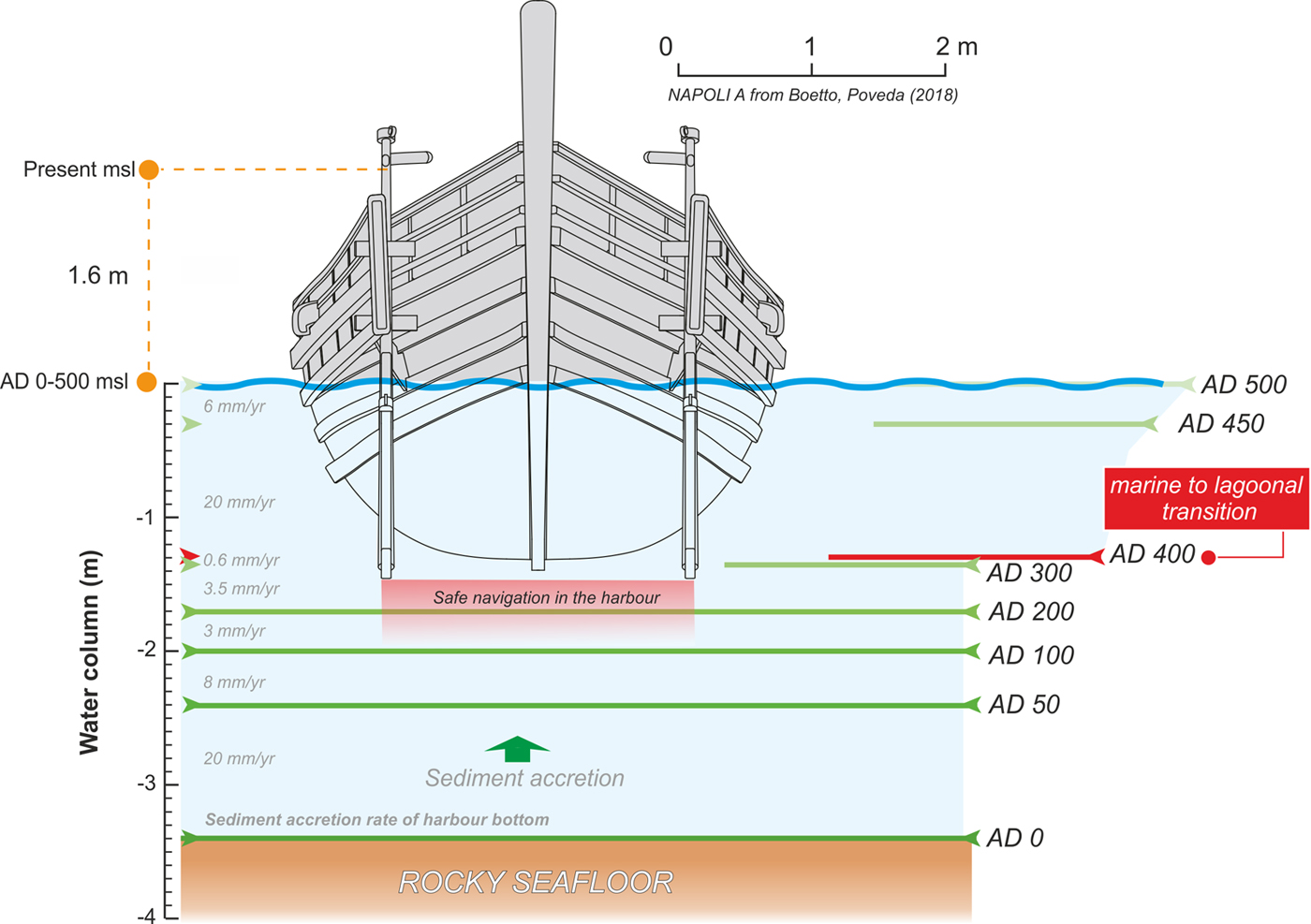
Impacts of RSL changes on the evolution of the harbour water column
The RSL stability observed between the first and the fifth centuries AD had significant implications for the use of the harbour during the Roman period. Silting problems inside the basin, probably related to increased sedimentation, are documented from the Hellenistic period until the second century AD (Di Donato et al., Reference Di Donato, Ruello, Liuzza, Carsana, Giampaola, Di Vito, Morhange, Cinque and Russo Ermolli2018), as testified by widespread evidence of dredging (Fig. 2A).
Figure 6 shows the reconstruction of the water column evolution in the basin according to both the RSL (Fig. 5) and the seafloor position (Fig. 4) during different periods. As stated previously, the maximum draft of the largest vessel found in the Augustan harbour of Naples was ~1.5 m (Boetto and Poveda, Reference Boetto, Poveda, Boetto and Rieth2018; Fig. 6). Our sea-level record, therefore, confirms that after the construction of the harbour structures (quay and pier) in the Augustan period, the harbour functioned for about two centuries (Giampaola et al., Reference Giampaola, Carsana, Boetto, Crema, Florio, Panza and Pizzo2006), as testified by the five shipwrecks dated between the end of the first century and the beginning of the third century AD found in the harbour (Fig. 2B; Boetto, Reference Boetto and Bockius2009; Boetto and Poveda, Reference Boetto, Poveda, Boetto and Rieth2018). By the end of the second century AD, circulation in the harbour started to become more difficult (Fig. 6) probably leading to the decline of port activities recorded in the third to fourth centuries AD (Giampaola et al., Reference Giampaola, Carsana, Boetto, Crema, Florio, Panza and Pizzo2006). This was also synchronous with a phase of abandonment highlighted by the decrease of horticultural activities around the harbour and the development of wild vegetation (Russo Ermolli et al., Reference Russo Ermolli, Romano, Ruello and Barone Lumaga2014). The sea-level stabilization in the first five centuries AD seems to have had minimal impacts on the harbour sedimentation. In fact, we observed great variability in the silting rates of the harbour despite the negligible RSL variation during the whole period. This variability is largely controlled by other factors such as deposition of human waste during the harbour apex (Di Donato et al., Reference Di Donato, Ruello, Liuzza, Carsana, Giampaola, Di Vito, Morhange, Cinque and Russo Ermolli2018) and the important sedimentary input linked to the AD 79 eruption and its subsequent reworking. Minimal traces of dredging activity following the eruption were found in front of the quay (Di Donato et al., Reference Di Donato, Ruello, Liuzza, Carsana, Giampaola, Di Vito, Morhange, Cinque and Russo Ermolli2018). However, these sporadic dredging scars cannot account for the sudden decrease in the rates of RSL rise observed from the end of the first century AD, which are probably of natural origin. No evidence of dredging activity was found after this period, further corroborating the progressive decline of harbour activities after the second century AD. Harbour sedimentation rates reincreased significantly only after the transition from a marine infratidal to a lagoonal environment.

Figure 6. (colour online) Sedimentation rates and evolution of the water column in the harbour basin. The progressive decrease in harbour draft depths is also denoted. Typical draft of the boat found in the harbour is based on Boetto and Poveda (Reference Boetto, Poveda, Boetto and Rieth2018). msl, mean sea level.
CONCLUSIONS
A multiproxy geoarchaeological investigation allowed us to reconstruct the millennial sea-level evolution in the ancient harbour of Naples, one of the most important Mediterranean cities. In this area, previous geoarchaeological investigations mainly focused on the RSL histories of the Roman to medieval period. Here, we were able to robustly constrain the RSL evolution since the Hellenistic period (end of the third century to second century BC). Since this time, RSL rose with average rates of ~2 mm/yr showing a nonmonotonic pattern mostly controlled by the area's complex volcano-tectonic setting. Increased negative land-level changes triggered a rapid RSL rise (~2.5 to ~2.0 mm/yr) in the first two centuries BC and in the post-Antiquity period (i.e., since the fifth century AD). This general trend of negative land-level changes was interrupted for five centuries (AD 50 ± 50 to 425 ± 25) when a significant deceleration of the RSL rising rates (~0.2 mm/yr) was observed. The causes of this stabilization of the RSL position are most likely related to a positive bradyseism period in the Phlegrean Fields area, even if future investigations are required to better constrain the role of the MSFZ in controlling the sea-level evolution of this densely populated area of the Mediterranean coastline.
Our results further confirm the extremely complex pattern of land-level changes in the Gulf of Naples where detailed spatiotemporal investigations into the variability of ground motion rates associated with volcano-tectonics represent a key tool to better quantify the current coastal hazard.
Acknowledgements
This article is dedicated to the memory of our friend and colleague Paola Romano who significantly investigated the coastal evolution of Naples in recent years. MV is funded by the Rita Levi Montalcini programme of the Italian Ministry of University and Research (MIUR). CM and MV thank the Labex OT-Med (ANR- 11-LABX-0061) and the A*MIDEX project (ANR-11-IDEX-0001-02). Our study is a contribution to the MOPP-Medflood (INQUA CMP 1603P) and HOLSEA (INQUA CMP 1601P) projects. We also extend our gratitude to the PALSEA 2 (PAGES/INQUA/WUN working group) and IGCP Project 639 communities for fruitful discussions during the workshops. We warmly thank Carlo Nike Bianchi and Carla Morri (DISTAV, University of Genova, Italy) who helped us with the identification of the fossil benthic species. Finally, we thank two anonymous reviewers and the associate editor Barbara Mauz who greatly improved the early version of the manuscript.