


Introduction
Recent advances in precise spatial referencing technologies and tools such as Global Position Systems and Geographic Information Systems have been fundamental to developments in the growing field of spatial ecology. A corollary of this is that historical spatial data are often imprecise, ambiguous or sometimes inaccurate, which can hinder or confound comparisons of recent and historical spatial data. Such comparisons are increasingly important as we try to understand the effects of environmental change on species' distributions.
In a large-scale study of the breeding distribution of Adélie penguins across East Antarctica, Southwell & Emmerson (Reference Southwell and Emmerson2013) found evidence of an expanding distribution over recent decades by comparing recent and historical occupancy surveys. However, because of the imprecision of spatial referencing in the historical surveys, they were unable to make conclusions on whether distributions had changed in some regions. One such region was in the south of Prydz Bay, where Adélie penguins breed at their most southerly extent in East Antarctica. In this short note, we visually examine original workings from a population survey in this region in 1981 (Whitehead & Johnstone Reference Whitehead and Johnstone1990) in combination with data from a recent survey in 2009 and a spatial reference and identification system for coastal East Antarctica (Southwell et al. Reference Southwell, Smith, Bender and Emmerson2021) to resolve uncertainties in the locations of historical breeding site observations. This approach enabled firm conclusions about historical distribution and recent decadal-scale change in distribution to be made. The spatial resolution of the breeding distribution considered in the studies cited above and in this study is at the scale of geographical sites of potential breeding habitat (i.e. islands and exposed continental rock close to the ocean). This spatial resolution is appropriate for studies of metapopulation dynamics and processes such as colonization and extinction at geographically separated habitat patches.
Methods
We examined the original working notes from the 1981 survey, compared these with data from the 2009 survey and searched for evidence to match observations of historical and recent breeding sites. The area of focus was between the Amery Ice Shelf and the Ranvik Glacier, particularly the Svenner, Steinnes and Bolingen islands, where location uncertainties occurred. The original working notes contained sub-colony boundaries and partial island coastlines that had been traced onto transparent paper from aerial photographs taken in the 1981 survey (archived in Whitehead et al. Reference Whitehead, Johnstone, Southwell and Emmerson2021). Data from the 2009 survey comprised stitched vertical aerial photographs covering each breeding site, sub-colony boundaries mapped as shapefiles, island coastlines mapped as shapefiles and geographical site identifiers and the locations of each island's centroid from the maps and database of the spatial reference system. We used the size, shape and configuration of sub-colonies, the location of sub-colonies on the island and the shape of the island's coastline as evidence for visually matching sites. If we were each confident of a match, knowing the identity of a recent observation from the spatial reference system allowed us to assign a geographical site and location to the historical observation.
Results
Despite fine-scale (≤ 10s of metres) changes in the pattern of sub-colony boundaries over three intervening decades and numerous gaps and uncertainties in the historical records of coastlines due to the presence of snow and ice, the combination of these general features was sufficient to give us high confidence in matching historical and recent observations of Adélie penguin breeding sites (Figs 1 & S1 & Table I). This was mainly facilitated by the general consistency of sub-colony locations and configurations over the three decades, reflecting the strong coloniality and site fidelity of this species. Confidence in matching was highest for the Svenner and Steinnes island regions and lower for the southernmost Bolingen Islands. There is some confusion in the historical records for the Bolingen area, with only one location mentioned in Whitehead & Johnstone (Reference Whitehead and Johnstone1990) but two maps of Bolingen locations in the working notes (Fig. S1). The matching process demonstrated that the 13 ‘locations’ described in the historical survey material represented 16 or 17 different islands. The exact locations inferred for these islands are shown in Table I, along with their unique identifying codes from the spatial reference system. Two locations in the historical survey each comprised two separate islands, one location comprised three separate islands, nine locations each comprised a single island and one location could not be identified. The cases of merged sites are most probably due to the presence of snow and ice obscuring coastlines (Fig. 1), but they may have also resulted from the relative coarseness of the maps available in the early 1980s.
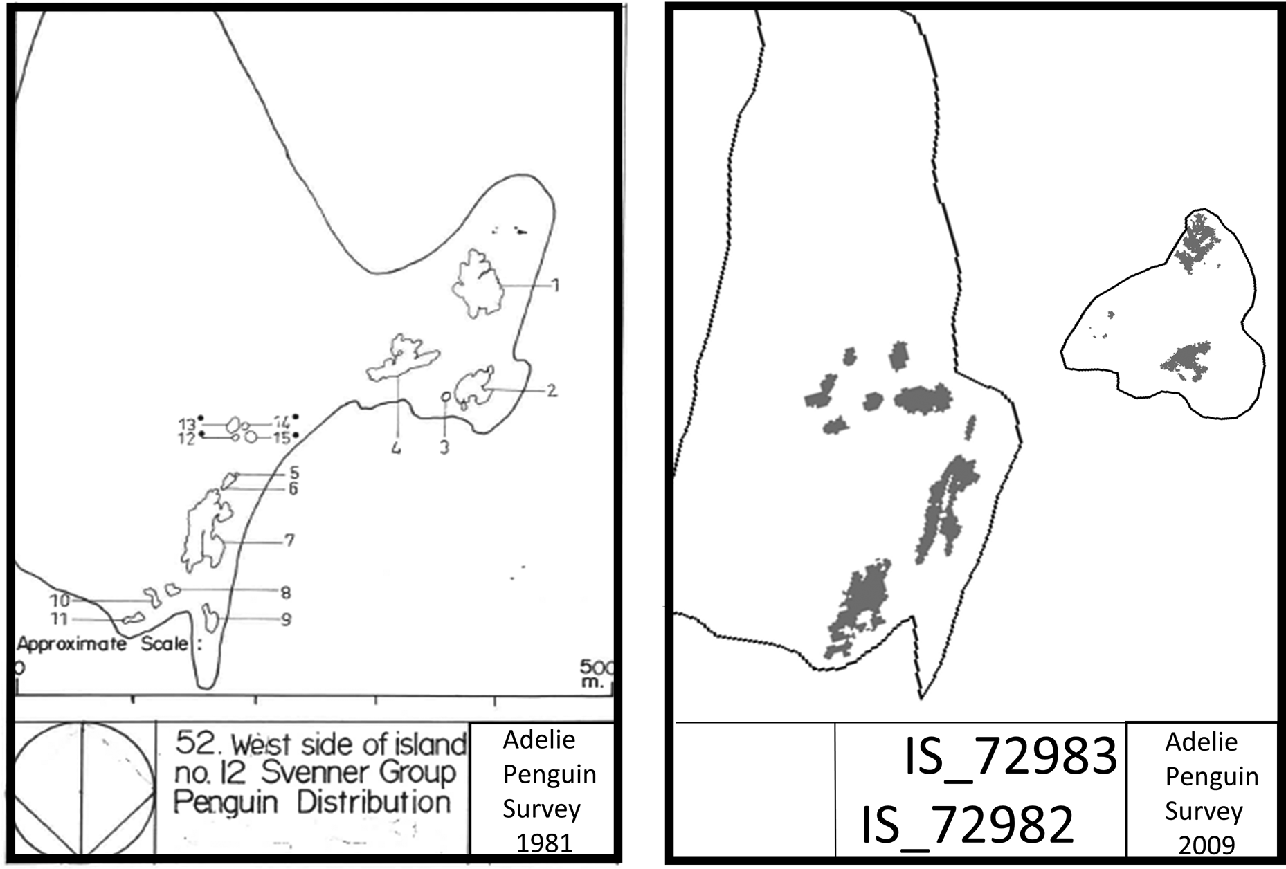
Fig. 1. Example of material used to assign breeding site location by matching historical (left) and recent (right) observations of sub-colony boundaries and island coastlines. In this case, a location reported as a single breeding site in the historical literature was concluded to represent two breeding sites at the spatial resolution of islands. Note that while sub-colony boundaries differ between historical and recent times at fine scales (metres), the overall configurations of sub-colony boundaries have strong similarities. The respective coastlines also show striking similarities, and differences in some areas are consistent with fast ice forming between the two islands, which probably led to inaccurate mapping in the historical survey.
Table I. Observations of occupied Adélie penguin breeding sites in southern Prydz Bay in 1981 as originally published in Whitehead & Johnstone (Reference Whitehead and Johnstone1990) (left), the specific geographical location(s) of those sites inferred from this study (centre) and observations of breeding occupation at those sites in 2009 from Southwell & Emmerson (Reference Southwell and Emmerson2013) (right). The row shading groups breeding sites into the locations reported in the 1981 survey.

a This site was not mentioned in Whitehead & Johnstone (Reference Whitehead and Johnstone1990).
Discussion
Having clarified the locations of these historical observations, we were able to compare the exact locations of the 17 identified occupied sites inferred from the historical survey with the 16 occupied sites found in 2009 (Table I). From this we conclude that the Adélie penguin breeding distribution in southern Prydz Bay has remained unchanged over the intervening three decades. This is consistent with a stable population size in this region over the same period, estimated from the historical survey at 24 965 breeding pairs in 1981 (Whitehead & Johnstone Reference Whitehead and Johnstone1990) and 25 700 occupied nests in 2010 (Southwell et al. Reference Southwell, McKinlay, Low, Wilson, Newbery, Lieser and Emmerson2013). With the uncertainty in these historical observations and the extent of any past changes in distribution resolved, a robust baseline now exists for assessing change in the future.
Supplemental material
A supplemental figure can be found at https://doi.org/10.1017/S0954102022000062.
Acknowledgements
We thank Michael Whitehead for making his original workings available to the Australian Antarctic Data Centre, and two reviewers for their constructive comments. This work was conducted as part of Australian Antarctic Science projects 4088 and 4518.
Author contributions
CS conceived the approach. CS and LE examined the historical data, wrote the manuscript and agreed on the final version.


