Introduction
The Caucasus is one of Eurasia's major archaeological “fault lines” (Kavtaradze Reference Kavtaradze and Sagone2004: 539). It is a region where the dynamics of prehistoric Europe and the ancient Near East pressed against one another, as shifting trade relationships, population movements and cultural entanglements shaped much of the Old World. The chronology of the prehistoric Caucasus is thus critical to the integration of existing regional datasets into a holistic chronology for Bronze and Iron Age Eurasia. While increasingly elaborate radiocarbon-based chronologies have been developed for Europe and South-west Asia (e.g. Manning et al. Reference Manning, Ramsey, Kutschera, Higham, Kromer, Steier and Wild2006, Reference Manning, Griggs, Lorentzen, Barjamovic, Ramsey, Kromer and Wild2016; Bronk Ramsey et al. Reference Bronk Ramsey, Dee, Rowland, Higham, Harris, Brock, Quiles, Wild, Marcus and Shortland2010; Whittle et al. Reference Whittle, Healy and Bayliss2011; Regev et al. Reference Regev, de Miroschedji, Greenberg, Braun, Greenhut and Boaretto2012), chronologies of the Caucasian ‘fault line’ have generally lacked the resolution of its neighbours. More than a decade ago, Sagona (Reference Sagona and Sagona2004: 477–78) noted three key factors limiting the development of Caucasian chronologies: a lack of clarity in the provenance of dated samples; a preponderance of single dates with overly broad confidence intervals; and a dearth of well-stratified archaeological sequences. Improvements in provenance reporting and a host of new radiocarbon determinations now allow for the creation of absolute chronologies that more rigorously define archaeological sequences and can be integrated into wider Old World radiocarbon syntheses (Cherry et al. Reference Cherry, Manning, Alcock, Tonikyan and Zardaryan2007; Passerini et al. Reference Passerini, Regev, Rova and Boaretto2016). Here we present the results of a 19-year programme of regional radiocarbon dating undertaken by the joint Armenian-American Project for the Archaeology and Geography of Ancient Transcaucasian Societies (Project ArAGATS), in the Tsaghkahovit Plain of north-western Armenia. This research has resulted in a Bayesian model that provides chronometric scaffolding for inter-regional tracking of population movements, technology transfers and social innovations that shaped Eurasia during the Bronze and Iron Ages (c. 3300–300 BC).
The Tsaghkahovit Plain (2000m asl) is an intermontane plateau covering approximately 260km2 at the base of the northern slope of Mount Aragats. The Plain is located on the watershed that divides the Araks and Kura river basins—a nodal point in the regional geography of the South Caucasus. Hence, even as the chronological data described below are localised to the Tsaghkahovit Plain, they are of broad utility to chronologies of the South Caucasus and neighbouring regions. Project ArAGATS has worked in the Tsaghkahovit Plain (Figure 1) since 1998, starting with an intensive pedestrian survey and followed by archaeological excavations at key sites for which the duration of occupation and preservation of remains offered the opportunity to make significant contributions to our understanding of the Bronze and Iron Age South Caucasus (Smith et al. Reference Smith, Badalyan and Avetisyan2009; Khatchadourian Reference Khatchadourian2014).

Figure 1. Map of the South Caucasus and surrounding regions with inset indicating the ArAGATS Project study area and the sites mentioned in the text (figure by Adam T. Smith).
The extant archaeological record of the region is dominated by three major phases of occupation that, in our initial chronological framework (Smith et al. Reference Smith, Badalyan and Avetisyan2009), we defined broadly as: the Early Bronze Age (c. 3500–2400 BC), the Late Bronze Age (c. 1500–1150 BC), and the Iron 3 period (c. 600–200 BC). In contrast with neighbouring regions, neither the regional survey nor our excavations in settlement and cemetery contexts have revealed clear evidence for Middle Bronze Age occupation. Here we provide a more refined definition of this record of occupation and hiatus via analysis of a large radiocarbon dataset. As of 2017, Project ArAGATS had acquired 236 radiocarbon dates on 214 samples (see the online supplementary material (OSM), Dataset 1); Table 1 summarises their distribution by site and sample type.
Table 1. Distribution of determinations by site and type.

Excavations at three sites (Gegharot, Gegharot Kurgans, Aragatsi Berd) in the Pambak foothills along the northern side of the Plain account for 62 per cent (n = 132) of the overall ArAGATS radiocarbon corpus. Early Bronze Age strata explored by Project ArAGATS are represented by 46 samples, while 94 samples come from Late Bronze Age deposits; 50 come from Iron Age 1–3 occupations, and two from more recent (medieval to modern) activity in the region. In addition to the corpus of radiocarbon determinations on individual archaeological samples, we investigated five dendroarchaeological samples (four from Gegharot, and one from the Iron 3 period at Tsaghkahovit), obtaining a series of dates for radiocarbon wiggle-matching (Bronk Ramsey et al. Reference Bronk Ramsey, van der Plicht and Weninger2001; Galimberti et al. Reference Galimberti, Bronk Ramsey and Manning2004). Alongside the growing radiocarbon corpus from the South Caucasus, new ceramic seriations have dramatically improved our ability to supplement radiocarbon data with increasingly sophisticated understandings of artefact sequences (Avetisyan Reference Avetisyan2003; Badalyan Reference Badalyan2014; Khatchadourian Reference Khatchadourianin press). The region, therefore, is well suited for the type of Bayesian modelling presented here.
Analysis
To refine our basic chronology (e.g. Smith et al. Reference Smith, Badalyan and Avetisyan2009), we developed a Bayesian model that integrates archaeological context and artefact sequence information with the radiocarbon dates from the late fourth millennium BC (initial Early Bronze Age) to the present (Bayliss Reference Bayliss2009; Bronk Ramsey Reference Bronk Ramsey2009a; Whittle et al. Reference Whittle, Healy and Bayliss2011). Such models permit definition and quantification, as well as queries concerning timespans and intervals between collected datasets. We employed the OxCal v4.3.2 software environment, including outlier analysis (Bronk Ramsey Reference Bronk Ramsey2009b) and the current IntCal13 radiocarbon calibration dataset (Reimer et al. Reference Reimer2013). For the Iron Age, three terminus post quem (TPQ) cross-references to Achaemenid historical dates and one tree-ring-sequenced radiocarbon wiggle-match provide possible additional tie-points. For the Late Bronze Age, three sets of tree-ring-sequenced, wiggle-matched radiocarbon dates are included as TPQ information. We employed short-lived samples for dating contexts where possible, as they offer dates directly relevant to the contexts of discovery; the majority of available samples, however, come from wood charcoal, which introduced issues of in-built age. We therefore employed the Charcoal Outlier Plus model in OxCal (Dee & Bronk Ramsey Reference Dee and Ramsey2014) to attempt to estimate with greater accuracy the date at which groups of charcoal samples from a context were the result of human use—especially when information from dates on short-lived samples could also be incorporated within a phase grouping. Our stated calendar date ranges are thus estimates of the dated periods or episodes, but, where a range of charcoal samples is involved, these probably still include some aspect of a TPQ range, and thus might be described as estimates of a close TPQ and/or date range. (For details, see the OSM.)
Of the original radiocarbon dataset, only six dates were excluded as substantial outliers. Two of these were due to a lack of clarity over the stratigraphic contexts of the samples, and four were due to poor fit with the model. The preferred ArAGATS chronological model (model 3) comprising all the remaining data (Table S1) offers good OxCal diagnostic statistics with typical Amodel and Aoverall values of 90.5 per cent and 75.9 per cent—both well above the satisfactory threshold of approximately 60 per cent. The few remaining minor outliers have been retained in the model (OSM). Table 2 summarises the primary results of the model.
Table 2. Results of the preferred Bayesian chronological model (model 3, see Figures S1A– & Table S2) for the Tsaghkahovit Plain, Armenia. All date spans cal BC are the 95.4 per cent highest posterior density (hpd) range (see Table S2). The dates from Gegharot are employed for the Early Bronze Age (EBA) and the Late Bronze Age (LBA) 2. The maximum and minimum values from pairs of sites are listed for Iron 1a and 1b.

Discussion
The Early Bronze Age
The Early Bronze Age in the region (Figure 2) is largely contemporaneous with the Kura-Araxes cultural complex, the latter defined by a distinctive array of materials, including ceramic vessels with black and red-black burnished surfaces. At Gegharot, the Early Bronze Age occupation is divided into two stratified horizons, defined by diagnostic Kura-Araxes ceramic assemblages. Early Bronze Age 1 layers (stratum 1a) contain a monochrome, minimally decorated, suite of ceramics known as the ‘Elar-Aragats’ type (Figure 3); Early Bronze Age 2 contexts (stratum 1b) are typified by the more diverse, highly ornamented ‘Karnut-Shengavit’ wares (Figure 4; Badalyan Reference Badalyan2014). The radiocarbon samples from Gegharot derive from a variety of archaeological contexts, including hearths, pits, tombs and destruction levels (with wood materials presumably accumulated from the start of the phase until its end). The Charcoal Outlier Plus modelling, the use of some short-lived samples and the uniform prior assumption for the phase groupings means that our date ranges probably represent reasonable overall occupation period estimates.

Figure 2. Early Bronze Age part of the ArAGATS Bayesian chronological model showing the modelled (dark grey/black, red, green and orange histograms) calendar dating probability distributions (the non-modelled calendar dating probabilities of the individual radiocarbon dates are shown by the background light grey histograms). The upper and lower lines under each distribution indicate, respectively, the modelled 68.2 per cent and 95.4 per cent highest posterior density (most probable) dating ranges. Inset A shows the modelled date estimates for stratum 1a1 and 1a from the Gegharot (Ar/Ge) sequence vs radiocarbon dates from Aparan III and Karnut (see the OSM and Figures S1–2 & S4–7). The other insets show the two indicated modelled distributions in detail.

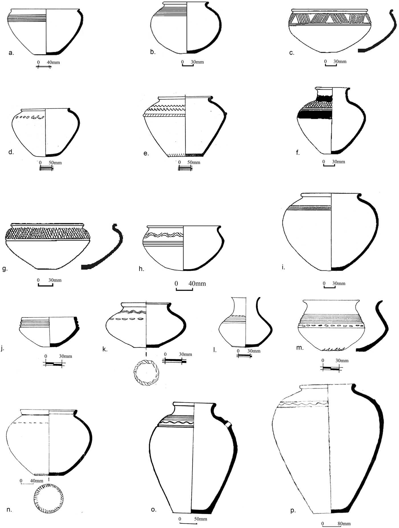
Figure 3. Early Bronze Age 1 ceramics of the ‘Elar-Aragats’ stylistic group from the lower level at Gegharot: a–d) operation T02E; e–i) operation T-18; j) operation T-17; k–o) operation T-12; p–z) operation T-30 (figure by Ruben Badalyan).

Figure 4. Early Bronze Age 2 ceramics of the ‘Karnut-Shengavit’ group from the upper levels at Gegharot: a–b, g, l, p–q) operation T-20; c, e–f, k) operation T02E; d, h, j, o) operation T-21; i) operation T-19; m–n) operation T-38 (figure by Ruben Badalyan).
The emerging chronological consensus on the initial Early Bronze Age places the earliest appearance of Kura-Araxes assemblages in the South Caucasus during the latter half of the fourth millennium BC, c. 3500/3350 BC (Sagona Reference Sagona2014). The two stratum 1a1 dates—both on charcoal and thus TPQ estimates—indicate poorly defined initial activity after or around 3278–3007 BC (Figures 2 & S1C, Tables 2 & S2) (note all calendar date ranges are at 95.4 per cent probability, unless otherwise stated). Stratum 1a is better represented as a stratigraphic entity, but is also relatively brief, dating from 3007–2906 BC; stratum 1b follows after (at most) a short hiatus, but with a longer overall age range modelled from 2864–2723 BC.
Dates from nearby sites suggest broadly similar initial occupation phases. Samples from Karnut in the eastern Shirak Plain indicate possible overlap with Gegharot 1a1; Aparan III (Badalyan Reference Badalyan2003) in the Kasakh Valley lies chronologically between Karnut and Gegharot, but also overlaps with both stratum 1a1 and 1a at Gegharot (Figures S4–7). The stratigraphically defined occupations at both Chobareti and Sos Höyük VA (Figure S11) similarly appear to have overlapped with Gegharot stratum 1a1 and 1a on the Tsaghkahovit Plain, but not 1b. This suggests that the posited hiatus between the Early Bronze Age 1 and Early Bronze Age 2 occupations at Gegharot occurred amidst a wider reorganisation of Kura-Araxes settlement. The Gegharot Early Bronze Age sequence overall is roughly contemporaneous with the Kura-Araxes occupation recently reported at Aradetis Orgora in Georgia (Passerini et al. Reference Passerini, Regev, Rova and Boaretto2016).
If there is any elasticity in the model, it is most probably in the dating of the close of stratum 1b. The most recent date on seeds (AA72067)—if not considered an outlier (see the OSM for details on the Bayesian chronological modelling (i), Figure S1D)—could extend into a more recent age range than the dates from late 1b contexts derived from teeth (non-modelled calibrated ranges on teeth samples AA109427–109431 range from 2759–2626 BC, while the range for AA72067 ends at 2490 BC). Thus, additional data might extend stratum 1b towards 2600/2500 BC. The abandonment of Gegharot's Early Bronze Age village sometime between the twenty-eighth and twenty-sixth centuries BC appears to have occurred only a little earlier than the initial transition to the Middle Bronze Age. A single radiocarbon determination from Martkopi Barrow 4 (Wk-35425) returns a calibrated range of 2617–2472 BC, while date ranges for the early Middle Bronze Age kurgans 5 and 10 at Bedeni indicate construction during the twenty-fifth to twenty-third centuries BC (cf. Boaretto et al. Reference Boaretto, Lev, Regev, Makharadze, Kalandadze and Murvanoryidze2016; Sagona Reference Sagona2017) (Figures S9–10).
Although two radiocarbon dates from the ArAGATS corpus suggest some as yet unrecognised Middle Bronze Age activity, we have documented no evidence of occupation in the Tsaghkahovit Plain until the transition from the Middle Bronze Age to the Late Bronze Age, just before 1500 BC. This is an extended hiatus in the regional occupation sequence, especially considering the evidence for Middle Bronze Age mortuary features found in neighbouring regions (e.g. Vanadzor, Aparani Berd and Harich). We currently lack a compelling explanation for this hiatus. One factor, however, may have been an increasingly cooler climate that limited resource availability at high altitudes, and thus constrained settlement and mortuary practices (Meller et al. Reference Meller, Arx, Jung and Risch2015).
The Late Bronze Age and Iron 1–2 periods
When settlement returned to the Tsaghkahovit Plain, it did so emphatically in the form of stone masonry fortresses of various sizes, perched atop many of the region's rocky prominences. The periodisation and chronology of the Late Bronze Age is poorly understood, due to both the dearth of reliable radiocarbon dates and the imprecision of ceramic typologies (but see Avetisyan & Bobokhyan Reference Avetisyan, Bobokhyan, Rubinson and Sagona2008). Late Bronze Age complexes are defined by a ceramic repertoire—known in Armenia as the Lchashen-Metsamor tradition—that favoured black, grey and buff wares with incised and pressed decorations around the circumference of the vessel's shoulder.
Our data indicate a Late Bronze Age occupation TPQ at Gegharot of 1546–1491 BC (Figure 5 & Table S2). Similarly, a single date from Gegharot Kurgan 2 (AA102805)—a burial that included a transitional Middle Bronze Age to Late Bronze Age ceramic assemblage (Figure 6)—indicates a boundary start date for stratum 2a (early Late Bronze Age 1) after or including 1524–1435 BC. This suggests that the transition from more mobile lifeways of the Middle Bronze Age to the firmly emplaced stone masonry fortresses of the Late Bronze Age began a generation or two earlier than previously thought.

Figure 5. The Late Bronze Age part of the ArAGATS Bayesian chronological model showing the modelled calendar dating probability distributions. See Figure 2 caption for details. Inset A shows the modelled calendar age length of the overall Late Bronze Age represented in the ArAGATS dataset. The other insets show details of the indicated modelled probability distributions.

Figure 6. Transitional Middle to Late Bronze Age (initial stratum 2a) ceramics from the west chamber of Gegharot Kurgan 2 (figure by Ruben Badalyan).
Stratum 2a at Gegharot is known predominantly from a series of deposits associated with the site's first destruction episode (1422–1246 BC, model 3—see Figure S1A–J & Table S2). These rarely appear as vertically stratified layers, due to subsequent rebuilding at the site. Instead, they tend to be identified as debris deposits that were created when subsequent stratum 2b construction cleared away the mixture of demolished architecture, burnt beams and destroyed material assemblages. Hence, stratum 2a deposits tend to be highly disturbed contexts that are horizontally stratified along with the extant 2b layers. As most dated 2a samples were wood charcoal, the material probably relates to a range of original 2a contexts from initial construction to activities undertaken at the site through the end of the phase. The defined stratum 2a material at Gegharot (Figure 7a–h), which we regard as later Late Bronze Age 1 and includes a mixed suite of Lchashen-Metsamor 1 and 2 ceramics, provides a date estimate of 1422–1246 BC (model 3) (Table S2).

Figure 7. Strata 2a (a–h) and 2b (i–m) ceramics from Gegharot: a–h) T21 shrine (Badalyan et al. Reference Badalyan, Smith, Lindsay, Khatchadourian and Avetisyan2008); i–m) T02E shrine (Badalyan et al. Reference Badalyan, Smith, Lindsay, Khatchadourian, Harutyunyan, Greene, Marshall, Monahan and Hovsepyan2014) (figure by Ruben Badalyan).
Two other sites on the Tsaghkahovit Plain, Hnaberd and Tsaghkahovit, also appear to have witnessed initial Late Bronze Age occupations concurrent with the founding of Gegharot. Stratum 2a at Gegharot lasted 0–110 years (68.2 per cent probability) or 0–223 years (95.4 per cent probability) in the main model (model 3)—and perhaps a little longer in the alternative model 3a (Table S2). The beginning of stratum 2b is defined stratigraphically by the first destruction episode at Gegharot, and archaeologically by a mixed assemblage of Lchashen-Metsamor 2 and 3 wares that place these contexts within the Late Bronze Age 2 phase (Figures 7i–m & 8). Stratum 2b dates to 1264–1186 BC at Gegharot based on samples from 2b contexts (or 1278–1146 BC from the stratum 2 general material) and appears to have been a relatively short period, only 0–45 years (68.2 per cent probability) or 0–106 years (95.4 per cent probability) in duration. Near the beginning of the Late Bronze Age 2 phase, a new fortress was constructed at Aragatsi Berd, probably one of the last sites built in the Tsaghkahovit Plain during the Late Bronze Age. The fortress sits at a strategic location that not only overlooks the Kasakh River Valley to the south, but also guards a key pass through the Pambak range to the north. Its construction, therefore, may represent a strategic response to the destruction episode that marked the end of stratum 2a at Gegharot.

Figure 8. Lchashen-Metsamor 2 (a–i) and 3 (j–p) ceramics from sites in neighbouring regions: a) Artashavan tomb 4; b) Artashavan tomb 3; c, f–g, i) Aparan III tomb 4; d–e) Nerkin Sasnashen tomb 1; h) Karasham tomb 117a; j) Mastara tomb 28; k–l) Mastara tomb 7; m) Mastara tomb 27; n) Oshakan tomb 88; o) Oshakan tomb 96; p) Oshakan tomb 95 (figure by Ruben Badalyan).
Nevertheless, sometime in the early to mid twelfth century BC, all of the Tsaghkahovit Plain fortresses appear to have been destroyed or abandoned in a single, coordinated episode. Our radiocarbon dates and model support this view: while the sampled sites display variation in dates for their Late Bronze Age 1–2 ranges, stratum 2b contexts all appear to end c. 1200 BC (Figure S3). We have suggested previously that the terminal stratum 2b destruction event not only marked the end of the Late Bronze Age in the Tsaghkahovit Plain, but also the beginning of another extended hiatus in regional occupation (Smith et al. Reference Smith, Badalyan and Avetisyan2009). Careful analysis of the radiocarbon dates and find contexts, however, suggests that small, ephemeral habitations did continue at Gegharot, Aragatsi Berd and Tsaghkahovit, sometime after the second destruction. Thirteen radiocarbon samples from Gegharot, eight from Tsaghkahovit and three from Aragatsi Berd indicate human activity following the end of the Late Bronze Age. The stratum 2c dates from Gegharot (1097–1002 BC) and Tsaghkahovit (1103–988 BC) appear to be largely limited to activity assignable to the Iron 1a phase, after a period of apparent Late Bronze Age 3 abandonment dating to 1169–1037 BC (Figure 9 & Table S2). Archaeologically, there are no clearly defined contexts attributable to stratum 2c at either Gegharot or Tsaghkahovit. The only extant evidence we have to accompany the data from the model are a few lines of stones high in the stratigraphic column and a small quantity of ceramic materials that hint at an Iron 1a habitation.

Figure 9. The Iron Age part of the ArAGATS Bayesian chronological model showing the modelled calendar dating probability distributions. See Figure 2 caption for details. Inset A shows in detail the modelled calendar age ranges for each of the overall Iron Age groups/phases. The other inset shows the estimated period of time (hiatus) between the Iron 1 and 3 phases in the ArAGATS dataset.
For Tsaghkahovit and Aragatsi Berd, the new chronological model also suggests the possibility of a stratum 2d occupation assignable to the Iron 1b phase. At Aragatsi Berd, the model indicates activity between 1006 and 777 BC, which is associated with the re-flooring of at least one paved room on the site's eastern terrace. It is difficult to assess whether this represents an isolated event or a more significant habitation. For Tsaghkahovit, the model suggests as yet archaeologically undefined Iron 1b activity c. 898–743 BC (Figure 9).
The uplands of eastern Anatolia (that portion of the Armenian Highlands encompassing contemporary Turkey, east of the Muş Plain) is a region where our refined chronological model for the Late Bronze Age/Iron 1 holds particular salience. Seemingly unaffected by the cataclysmic events that brought an end to the Late Bronze Age across much of the Eastern Mediterranean, the highland polities of eastern Anatolia appear to have been less intimately bound to the political and economic fortunes of Near Eastern territorial states than their lowland neighbours. For much of the Bronze Age, the basic contours of eastern Anatolian material culture sequences follow the trajectories of the South Caucasus much more closely than those of the Near East. As in the South Caucasus and northern Iran, for example, surveys in eastern Anatolia over the past two decades (e.g. Isıklı & Can Reference Işıklı, Can, Çilingiroğlu and Sagona2007; Özfırat Reference Özfırat2009) have resulted in a surge in the number of recorded Late Bronze Age/Iron 1 sites. This allows us to trace more fully their geographic extent in the highland plateau. In addition, Özfirat notes that collections of Middle Bronze Age and Late Bronze Age pottery from the Ağri Dağ (Mount Ararat) region display “full parallelism with the pottery of [the] South Caucasus” (Özfirat Reference Özfırat2009: 226), while Isıklı (Reference Isıklı, Mehnert, Mehnert and Reinhold2012: 225) draws similar parallels to Lchashen-Metsamor wares from Late Bronze Age/Iron 1 contexts at Pulur and Sos Höyük in north-eastern Anatolia. To date, however, Sos Höyük remains the only site in eastern Anatolia that has provided a stratified sequence of radiocarbon dates (Sagona Reference Sagona, Marro and Hauptmann2000), six of which date to the Late Bronze Age (Sos III), c. 1500–1000 BC, and the Early Iron Age (Sos IIA), c. 1000–800/750 BC (Sagona & Sagona Reference Sagona and Sagona2003: tab. 1). The excavators emphasise the provisional nature of the Sos periodisation, pending further excavations of stratified Late Bronze Age/Iron 1 deposits from a greater range of contexts in the region and statistical analysis of associated pottery types. Their radiocarbon dates, however, provide useful comparanda for the chronological model that we propose here. Intriguingly, there appears to be another hiatus in the occupation of the Tsaghkahovit Plain during the Iron 2 period, from 783–539 BC. This coincides in part with the era of Urartian hegemony north of the Araxes, although settlement returns following the Urartian collapse in the second half of the seventh century BC (Kroll Reference Kroll1984).
The Iron 3 period
Political histories constructed from narrative and epigraphic texts provide an autonomous and, by convention, authoritative basis for periodisation and chronology in the South Caucasus from the ninth century BC. There was, however, a problematic interval in the mid first millennium BC, between the collapse of Urartu in the seventh century BC and the emergence of the Hellenistic cities in the third century BC. Independent dating is thus a key desideratum in order to understand changes associated with the rise and fall of the Achaemenid Persian Empire (c. 550–330 BC)—an ambitious imperial formation that brought the South Caucasus into its fold and transformed much of the ancient world (Khatchadourian Reference Khatchadourian2014, Reference Khatchadourian2016). Until now, the so-called Hallstatt plateau in the radiocarbon calibration curve has restricted efforts to employ radiocarbon; our model, however, integrates archaeological sequences, historical markers and tree-ring wiggle-matches, and represents a significant advance (Figure 9).
Project ArAGATS's findings identify the return of significant habitation precisely during this poorly understood period. When populations returned to the Tsaghkahovit Plain following the Iron 2 hiatus, they favoured the abandoned locales of Late Bronze Age sites. The Iron 3 settlement at Tsaghkahovit points to large-scale, year-round occupation that endured for approximately 250 years.
Although an ‘early’ regional occupation phase is not visible as a distinct cultural layer, an Iron 3a phase (640–540 BC) can be approximately defined within the model by assigning to it those Iron 3 radiocarbon determinations on charcoal samples that were not clearly associated with the final Iron 3b phase floors (i.e. samples that were either stratigraphically deep, or from features that may have had long use-life). Conversely, the Iron 3b phase contains dates on samples retrieved from floor surfaces that are high in the stratigraphic sequence (e.g. associated with flagstone floors), or the contexts where rare diagnostic artefacts make a pre-Achaemenid date highly unlikely. A serpentine plate from Tsaghkahovit provides archaeological-historical grounds for extending this Iron 3b period past 486 BC (see section (xx) in the OSM for details on the Bayesian chronological modelling); the Bayesian model accommodates this reconstruction (Figure 9).
The chronological model for the Iron 3 period on the Tsaghkahovit Plain relies heavily on a wiggle-match TPQ and archaeological and historical inputs, from the 640 BC TPQ for phase Iron 3a, to the 540 BC and 486 BC TPQs for phase Iron 3b—especially as dates on short-lived samples for the Iron 3 period are lacking. Nevertheless, all of the radiocarbon determinations from the site of Tsaghkahovit can accommodate these parameters, producing a model with no outliers. Due to limited stratigraphic differentiation, the model is unable to aid in the identification of material culture change from the first century of its occupation, during the so-called ‘Median’ period to the Achaemenid era. But what the radiocarbon dates do provide—independent of the archaeological evidence—is a picture of a predominately early Achaemenid-era settlement; only one of the samples, which were collected from a wide array of contexts, tentatively suggests a post-fifth-century BC date. This is of considerable significance, as it allows the development of a more refined pottery typology for the period that can reveal technological and social changes across the centuries of Achaemenid Persian rule in its northern province (Khatchadourian Reference Khatchadourianin press). When examined in the context of other emerging radiometric dating programmes in the region—at Oglanqala (Ristvet et al. Reference Ristvet, Gopnik and Bakhshaliyev2012), for example—it becomes possible to envision a more rigorous archaeological understanding of early historic periods in the South Caucasus (Figure 10).
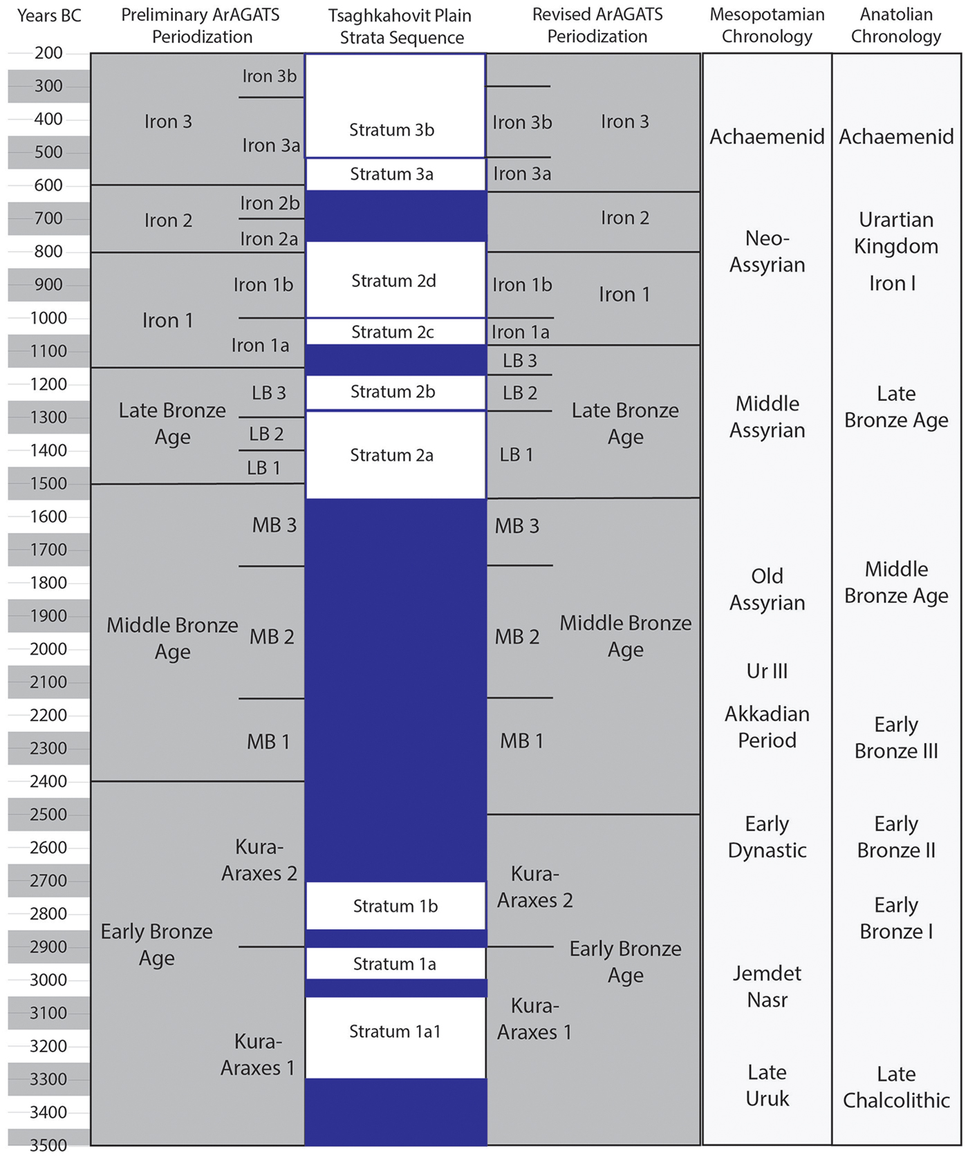
Figure 10. Chronological periods and timeline for the ArAGATS project sites/area and stratigraphic sequences in schematic terms comparing previous definitions and approximate temporal placements vs those resulting from the work reported in this study.
Conclusion
The chronology of the Kura-Araxes communities of the Early Bronze Age is a matter of extensive current debate, with disagreements over the timing of both their beginning and end (see Marro et al. Reference Marro, Berthon and Bakhshaliyev2014, Reference Marro, Bakhshaliyev and Berthon2015; Palumbi & Chataigner Reference Palumbi and Chataigner2015). Although the data from the Tsaghkahovit Plain do not resolve this debate, it is important to note how Bayesian modelling of the large ArAGATS dataset significantly refines the main periods of occupation at Gegharot. Our initial impression of a village occupied from c. 3300–2500 BC can now be focused on just two and a half centuries. This suggests that there may be other sites where occupation phases have been over-inflated and will move into narrower chronological frames with additional research. Similarly, the absolute chronologies of the Late Bronze Age and Iron Age sequences in the South Caucasus have received less attention compared to the seriation of ceramic sequences. The ArAGATS data provide a scaffolding for linking the two, although there is a clear syncopation in the specific history of local settlement and the wider trends in ceramic production. Hence, there is considerable need for similarly large datasets from other regions in order to cross-reference material changes with wide-scale settlement histories.
The South Caucasus occupies a distinctive place in Old World archaeology. Interstitially located between Mesopotamia and the Eurasian steppe, its societies were enmeshed in the seminal transformations that define the study of ancient South-west Asia—from the emergence of village life to the rise of empires (Figure 10). Archaeological research in the region has revealed that the contours of social life during the Bronze and Iron Ages were neither derivative nor autonomous of neighbouring civilisations (Smith Reference Smith2015). In this context, chronological precision thus permits historical reconstructions that bring attention to the range of solutions devised by closely connected societies to address the challenges posed by a world of increasing socio-political complexity.
Acknowledgements
This project was supported by grants from The National Science Foundation (BCS-0073519, BCS-0507370, BCS-0808151, BCS-0964145, BCS-1561240), the Wenner-Gren Foundation, the National Endowment for the Humanities, the National Geographic Society, the University of Chicago's Department of Anthropology, the Cornell Institute for the Social Sciences, The Einaudi Center at Cornell University, Purdue University, the U.S. Department of Education, the American Research Institute of the South Caucasus and the Stanford University Archaeology Center. We wish to thank the University of Arizona Accelerator Mass Spectrometry Laboratory and the Klaus-Tschira-Laboratory for radiometric dating methods, and the Curt-Engelhorn-Centre for Archaeometry. We also thank the Cornell Tree Ring Laboratory, and especially Kate Seufer and Brita Lorentzen.
Supplementary material
To view supplementary material for this article, please visit https://doi.org/10.15184/aqy.2018.171